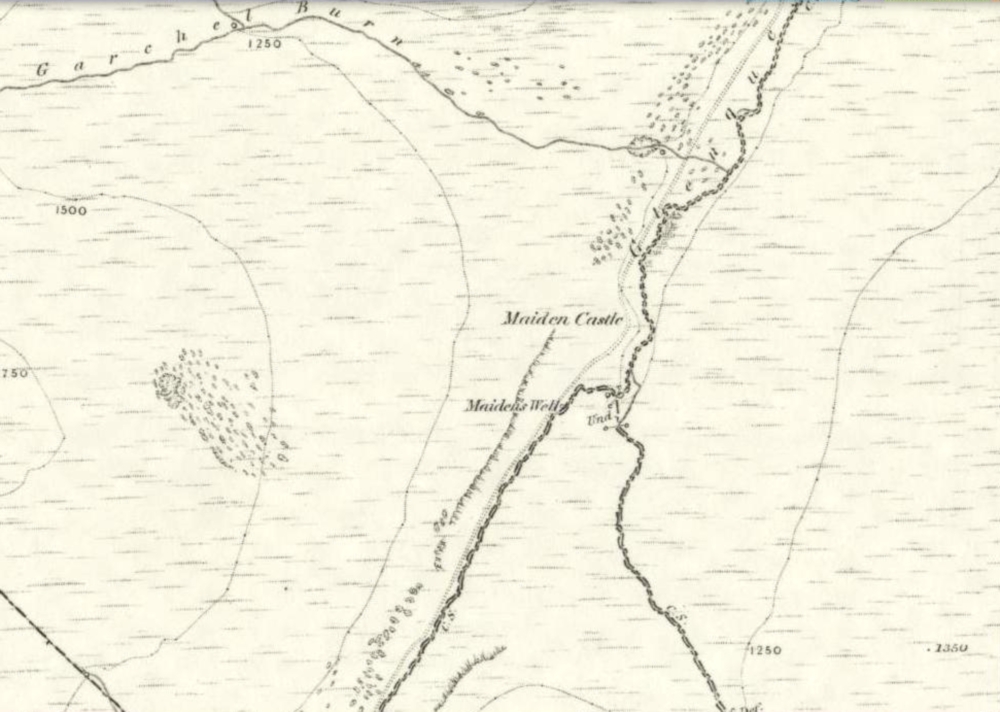
1860 map showing Maiden Castle (and the Maiden’s Well)
Take the small steep road uphill from the town of Dollar in Clackmannanshire towards Castle Campbell. Less than 100 yards above the small parking spot by the small white house near the top of the hill, turn to walk up the footpath on your right above the house, following the edge of the depleted forestry plantation parallel with the valley. Cross the valley a few hundred yards up, but keep to path on the other side that stays parallel with the stream. You’ll hit a small rocky glen a half-mile up. Walk thru it, alongside the very edge of the forest till the trees break and there’s a gap in the hills. You’ve just walked past the Maiden’s Well and in front of you is a large natural rounded hill, which the footpath bends around. This hill is the Maiden Castle. (if you walk round this, a view into the eastern hills and a small lake opens up ahead of you)
Archaeology & History
The fairy hill of Maiden Castle
A large rounded hill marking the opening of Glenquey to the north and the Glen of Care to the south. Although ascribed in place-names old and new as a ‘castle’, there are no remains as such left here to account for this title. Angus Watson (1995) tells of the possibility of the place deriving its name from the Gaelic Creag Ingheann, or maiden crag. In Bruce Baillie’s (1998) survey of the area, in trying to give some relevance to the place-name, he points out that whilst no hillfort or cairn that might help account for the folklore (see below),
“Large-scale maps indicate a spot opposite on Hillfoot Hill as Greig’s Grave. There would seem to be something ancient here but of what nature it is, at the moment, impossible to say.”
When we visited the place yesterday, snow still covered much of the ground hereby, so we couldn’t do our usual explorations seeking for old sites (even the hut circles 100 yards away were covered over). The legendary healing waters of the Maiden’s Well are below here, by the side of the burn.
Folklore
This large rounded hillock was evidently a place of some importance in bygone days if the folktale here is anything to go by. Although the story echoes the some of the core sequences of modern ‘close encounter’ abduction events, other ingredients here tell of more arcane peasant rites that were once part of the social structure of our ancient heathen tribes:
“A piper, carrying his pipes, was crossing from Glendevon to Dollar in the grey of the evening. He crossed the Garchil (a little stream running into the Quaich), and looked at the Maiden Castle and saw only the grey hillside and heard only the wind soughing through the bent. But when he had passed beyond it, he suddenly heard a burst of lively music and turned round to look at what was causing it. And there, instead of the dark knoll which he had seen a few moments before, he beheld a great castle, with lights blaring from the windows, and heard the noise of dancing issuing from the open door. He went back somewhat incautiously to get a closer view, and a procession issuing at that moment from the Castle’s open door, he was caught up and taken into a great hall ablaze with lights, while people were dancing on the floor. He was at once asked to pipe to them and was forced to do so, but agreed to do so only for a day or two. At last getting anxious, because he knew his people would be wondering why he had not come back in the morning, as he had promised to do, he asked permission to return home. The faeries seemed to sympathise with his anxiety and promised to let him go if he played a favourite tune of his, which they seemed fond of, to their satisfaction. He played his very best. The dance went fast and furious, and at its close he was greeted with loud applause. On his release he found himself alone in the grey of the evening, beside the dark hillock, and no sound was heard save the purr of the burn and the soughing of the wind through the bent. Instead of completing his journey to Dollar, he walked hastily back to Glendevon in order to relieve his folk’s anxiety. He entered his father’s house and found no kent face there. On his protesting that he only gone away for a day or two before, and waxing loud in his bewildered talk, a grey old man was aroused from a doze beside the fire, and told how he had heard when a boy from his father that a piper had gone away to Dollar on a quiet evening, but had never been seen or heard since, nor any trace of him found. It turned out the piper had been in the ‘Castle’ for a hundred years.”
The Fortean experts John Keel (1971) and Jacques Vallee (1970) both contended, quite rightly, that some aspects of the ancient encounters related in such folklore has strong parallels to modern UFO ‘abduction’ events. In addition, Paul Devereux (1989) cites that such events occur where strong geomagnetic forces exist in proximity to rock outcrops, as found here.
There is the additional feature in these stories of the music of both faerie and pipers alike, whose revelling jigs carry the mortal out of time and, when returning back to human life, find no one recognises them. This is a condition of some rites of passage in traditional societies, where mothers and fathers no longer recognise their child after they have been through the rituals after visiting spirit-lands and returning as adults for the first time: an element in our faerie-lore that has been overlooked in assessing the nature of these fascinating tales.
References:
Baillie, Bruce, History of Dollar, DMT: Dollar 1998.
Devereux, Paul, Earthlights Revelations, Blandford: London 1989.
Fergusson, R. Menzies, The Ochil Fairy Tales, David Nutt 1912.
Keel, John A., UFOs: Operation Trojan Horse, Souvenir Press: London 1971.
Rhys, John, Celtic Folklore – Welsh and Manx: volume 1, Oxford University Press 1901.
Vallee, Jacques, Passport to Magonia: From Folklore to Flying Saucers, Tandem: London 1975.
Watson, Angus, The Ochils: Placenames, History, Tradition, PKDC: Perth 1995.
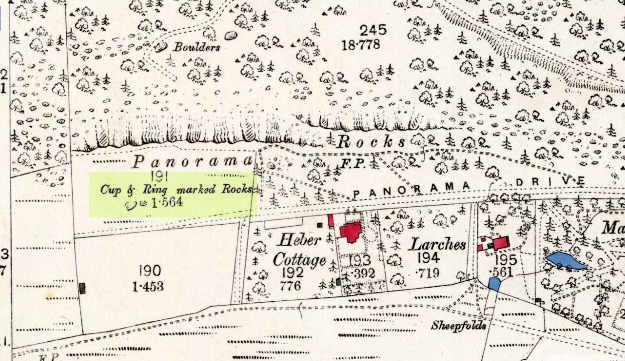
Come out of Ilkley/bus train station and turn right for less than 50 yards, heading left up towards White Wells. Go up here for less than 100 yards, taking your first right and walk 300 yards up Queens Road until you reach the St. Margaret’s church on the left-hand side. On the other side of the road, surrounded by trees is a small enclosed bit with spiky railings with Panorama Stones 227, 228 and 229 all therein: the least-decorated one on the left being the one we’re dealing with here.
Archaeology & History
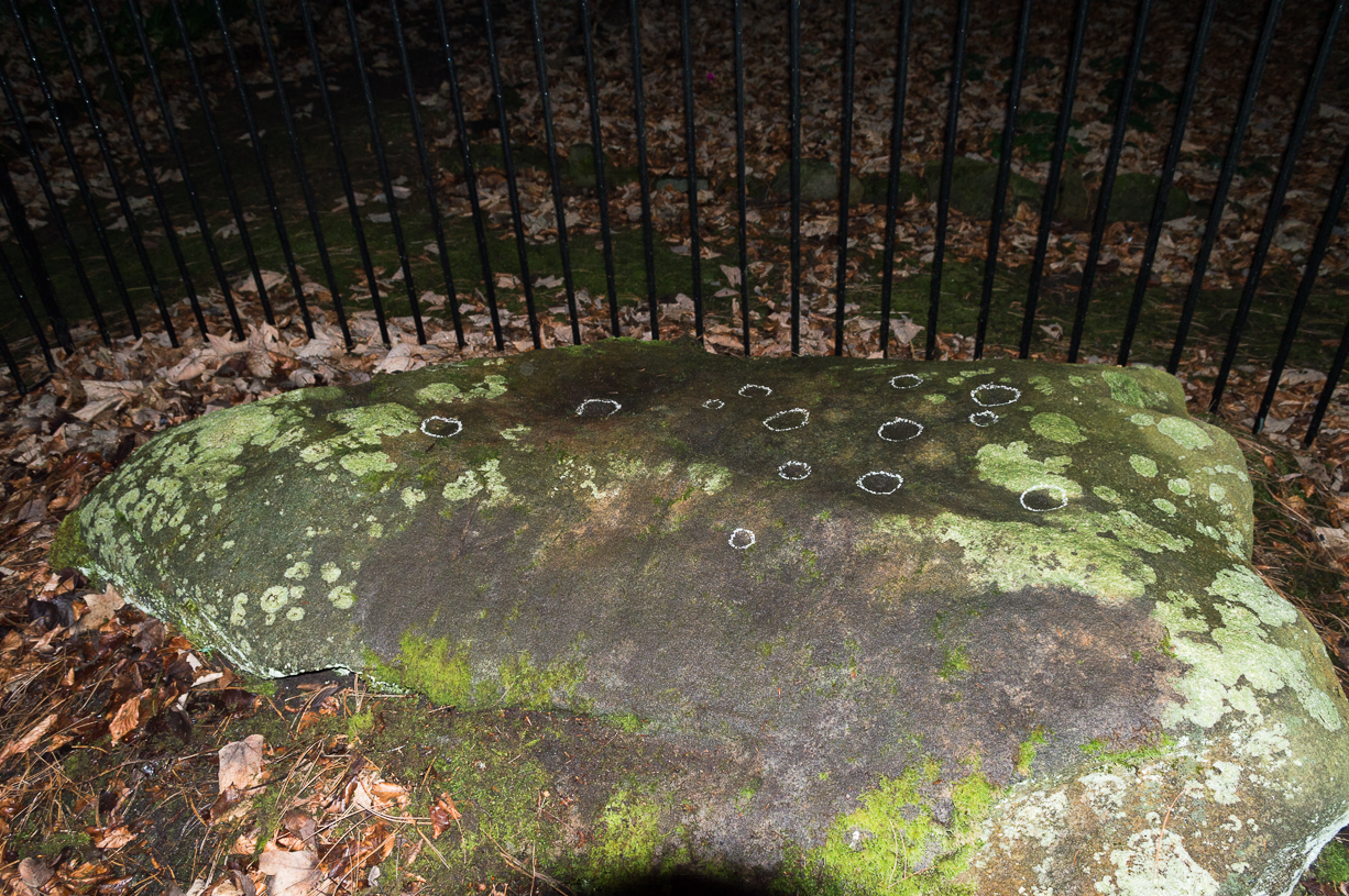
This is another of the caged Panorama Stones, found within the awful spiked fencing across from St. Margaret’s Church, just out of Ilkley centre. Originally located ¾-miles (1.2km) WSW of its present position in Panorama Woods (at SE 10272 46995), along with its petroglyphic compatriots in this cage, the carving was moved here in 1890 when a Dr. Little—medical officer at Ben Rhydding Hydro—bought the stones for £10 from the owner of the land at Panorama Rocks, as the area in which the stones lived was due to be vandalized and destroyed. Thankfully the said Dr Little was thoughtful and as a result of his payment he had some of the stones saved and moved into their present position.
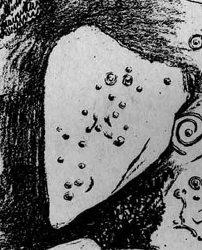
Original location of stonesJ.T Dale’s 1879 sketch
It was first described by the northern antiquarian and petroglyph pioneer, J. Romilly Allen (1879) , who saw it in the now-destroyed “rough inclosure”, as he called it, along with the other stones now in the same Ilkley ‘cage’. Its present position does it no justice whatsoever in terms of its original position. It was ostensibly a rocking stone: this seemingly trivial-looking boulder was sat on top of the much-cropped Panorama Stone 228 (a yard east of the three in this outdoor cage). Allen (1879) was fortunate enough to have seen the stone before it was uprooted, telling us how this topmost stone, “has eleven cups, wo of which are surrounded by single rings.” The modern archaeologist John Hedges (1986) told it to be in a “bad state,” with “very worn carvings, fourteen cups, one with partial ring and groove.” Its situation deteriorated further, as stated by rock art students Boughey & Vickerman (2003), who noted,
“medium-sized, roughly triangular rock, its surface recorded as in a bad state in 1986 and now (2002) even worse. Fourteen cups, one with partial ring, one groove.”
And its condition isn’t helped by its inaccessibility, when groups like the ‘Friends of Ilkley Moor’ or the local archaeologist should be at least annually cleaning this and the adjacent carvings. If they’re incapable, there are sincere people in antiquarian, history and pagan groups who would probably help out…
John Hedges 1986 sketchFaint cupmarks visible
In truth, this carving cannot be seen in isolation, nor merely reduced to a numeric catalogue in some rock art corpus. We must contextualize its relationship with the once much-larger multiple cup-and-ring stone on which it sat and then see it as it was in the landscape. Originally of course the rocking stone was Nature’s very own creation. As humans began migrating over and eventually occupying this once-wooded arena, the rocking stone became intimately related with animistic magickal rites and, over time, petroglyphs began to be etched upon the stone. Most probably the flat underlying rock surface was carved upon first, and a symbiotic relationship was forged between Earth’s surface and the small rocking stone, both of which were used in oracular and other rites. Over centuries, as the cups and rings on the earthfast stone grew, the mythic status of this small rocking stone allowed for the encroachment of carvings, and eventually cup-marks began to be etched upon it too. Later still, as the neolithic period moved into the Bronze Age, the people began to build a low-walled stone enclosure around this and the nearby multiple-ringed carving – similar to the multi-period enclosure at Woofa Bank and other sites on these moors. It was all a very long and gradual process.
In truth, the mythic status of this once-impressive site would have been maintained—in one form or other—well into the medieval period. But that’s another matter altogether…
Bennett, Paul, The Panorama Stones, Ilkley, TNA: Yorkshire 2012.
Bennett, Paul, Aboriginal Rock Carvings of Ilkley and District, forthcoming.
Boughey, Keith & Vickerman, E.A., Prehistoric Rock Art of the West Riding, WYAS: Leeds 2003.
Cowling, Eric T., Rombald’s Way, William Walker: Otley 1946.
Downer, A.C., “Yorkshire Archaeological and Topographical Association,” in Leeds Mercury, August 28, 1884.
Eliade, Mircea, The Sacred and the Profane: The Nature of Religion, Harcourt, Brace & World: New York 1959.
Hadingham, Evan, Ancient Carvings in Britain, Souvenir Press: London 1974.
Hedges, John, The Carved Rocks on Rombald’s Moor, WYMCC: Wakefield 1986.
Heywood, Nathan, “The Cup and Ring Stones of the Panorama Rocks”, in Transactions Lancashire & Cheshire Antiquarian Society, Manchester 1889.
Speight, Harry, Upper Wharfedale, Elliott Stock: London 1900.
Acknowledgements: With huge thanks to both Dr Stefan Maeder for help in cleaning up the stones; and to James Elkington for allowing use of his photos in this site profile.
Legendary Stone & Healing Well (lost): OS Grid Reference – NN 579 323
Also Known as:
Fuaranna Druidh Chasad
Whooping Cough Well
Archaeology & History
“Well of the Whooping Cough” stone, near Killin
The grid-reference given for this site is only an approximation based on the description given by Hugh MacMillan (1884), below. The exact whereabouts of the place remains forgotten, but based on the story we have of the place it would be great if we could locate it and — as far as I’m concerned — be highlighted and preserved as an important spot in the history of religious and social history for the people of Killin and the wider mountain community. The region here was well populated all along the northern and southern sides of the adjacent Loch Tay before the coming of the Highland Clearances (Prebble 1963), and so the lore which MacMillan describes below was very likely of truly ancient pedigree.
Not to be confused with a site of the same name (and attributes) as the healing well at Balquhidder, this site comprises of a large stone, typical of the region, covered in that delicious carpet of old mosses and lichen bestowed by the aged love from Nature that bedecks much of the hidden sites in the area. Upon one side of the rock was a large hollow, in which water was always collected: of both dew and rain and the breath of low clouds, within which were great medicinal virtues long known of by local people. Foreign or shallow archaeologists would denounce this rock and its virtues as little more than the superstitious beliefs of an uneducated people living in uneducated times, but such derision is simply foolish words from pretentious souls who know little of the real world. For the attributes and mythic elements at this old stone is another example of living animism: vitally important ingredients in the spiritual background and nourishment of a people not yet overcome by the degrading influence of homo-profanus. Here we still find the living principles of the natural world, sleeping away in the consensus trance of modern folk…
Folklore
The stone and its ‘healing well’ are not mentioned in the standard Scottish texts on holy wells (MacKinlay 1893; Morris 1982) and we have to rely solely on Hugh MacMillan’s first-person account of the place from the latter-half of the 19th century. He told that the stone was to be found “in the woods of Auchmore at Killin,” some twelve miles from a similar curative rock at Fearnan called the Clach-na Cruich:
“This stone is called Fuaranna Druidh Chasad, or the Well of the Whooping-Cough. I heard of it incidentally last year in Paisley from a native of Killin, who remembered vividly when a boy having been taken to drink the water in the cavity of the stone, in order to cure the whooping-cough, from which he was suffering at the time. Happening to be in Killin lately, enjoying a few days’ holiday, I made inquiries in the village; but though some of the older inhabitants remembered having heard of the stone, and the remarkable practice connected with it, I could not get any one to describe the exact locality of it to me, so completely has the superstition passed away from the mind of the present generation. I went twice in search of the stone; and though, as I afterwards found, I had been within a very short distance of it unawares on both occasions, I was unsuccessful in finding it. At last I met an old man, and after some search we found the stone, and he identified it.
“I understood then what had puzzled me before, viz., why it should have been called Fuaran or Well, for I had supposed it had a cavity in a stone like that at Fernan. It was indeed a cavity; but it was in the projecting side of the stone, not on its top surface. It consisted of a deep basin penetrating through a dark cave-like arched recess into the heart of the stone. It was difficult to tell whether it was natural or artificial, for it might well have been either, and was possibly’ both; the original cavity having been a mere freak of nature — a weather-worn hole — afterwards perhaps enlarged by some superstitious hand, and adapted to the purpose for which it was used. Its sides were covered with green cushions of moss; and the quantity of water in the cavity was very considerable, amounting probably to three gallons or more. Indeed, so natural did it look, so like a fountain, that my guide asserted that it was a well formed by the water of on underground spring bubbling up through the rock. I said to him, “Then why does it not flow over?” That circumstance he seemed to regard as a part of its miraculous character to be taken on trust. I put my hand into it, and felt all round the cavity where the water lay, and found, as was self-evident, that its source of supply was from above and not from below; that the basin was simply filled with rain water, which was prevented from being evaporated by the depth of the cavity, and the fact that a large part of it was within the arched recess in the stone, where the sun could not get access to it. I was told that it was never known to be dry — a circumstance which I could well believe from its peculiar construction.
“The stone, which was a rough irregular boulder, somewhat square-shaped, of mica schist, with veins of quartz running through it, about 8 feet long and 5 feet high, was covered almost completely with luxuriant moss and lichen; and my time being limited, I did not examine it particularly for traces of cup-marks. There were several other stones of nearly the same size in the vicinity, but there was no evidence, so far as I could see, of any sepulchral or religious structure in the place. There is indeed a small, though well-formed and compact so-called Druidical circle, consisting of some seven or eight tall massive stones, with a few faint cup-marks on one of them, all standing upright within a short distance on the meadow near Kinnell House, the ancestral seat of the Macnabs, and it is a reasonable supposition that the Fountain of the Whooping-Cough may have had some connection in ancient times with this prehistoric structure in its immediate neighbourhood; for, unlike the cavity in the stone at Fernan, the peculiar shape of the cavity in this stone precluded its ever having been used as a mortar, and apparently it has never been used for any other purpose than that which it has so long served. There can be no doubt that the fountain dates from a remote antiquity; and the superstition connected with it has survived in the locality for many ages. It has now passed away completely, and the old stone is utterly neglected. The path leading to it, which. used to be constantly frequented, is now almost obliterated. This has come about within the last thirty years, and one of the principal causes of its being forgotten is that its site is now part of the private policies of Auchmore. The landlady of the house at Killin, where I resided, remembered distinctly having been brought to the stone to be cured of the whooping-cough; and, at the foot of it, there are still two flat stones that were used as steps to enable children to reach up to the level of the fountain, so as to drink its healing waters; but they are now almost hidden by the rank growth of grass and moss. There is more verisimilitude about the supposititious cures effected at this fountain than about those connected with the stone at Fernan; for one of the best remedies for the whooping-cough, it is well known, is change of air, and this the little patient would undoubtedly get, who was brought, it may be, a considerable distance to this spot. I am led to understand that, in connection with the cure, the ceremonial turn called “Deseul” was performed. The patient was required, before drinking the water, to go round the stone three times in a right-hand direction, which may be regarded as an act of solar adoration. This practice lingered long in this as in other parts of the Highlands, and the “deseul” was religiously performed round homesteads, newly-married couples, infants before baptism, patients to be cured, and persons to whom good success in some enterprise was wished; while the “Tuathseul,” or the unhallowed turn to the left, was also performed in cases of the imprecation of evil.”
Should anyone know the whereabouts of this fascinating healing stone and its waters, please let us know!
References:
MacKinlay, James M., Folklore of Scottish Lochs and Springs, William Hodge: Glasgow 1893.
From Marsden itself, take the A62 road west and where the road bends round, the large hill rising on your left is where you’re heading. There’s a parking spot near the bottom of the highest part of the hill. From here, walk right to the top, up whichever route you feel comfortable with. At the very top is an intrusive modern monolith (dedicated to somebody-or-other, which the fella wouldn’t approve of if he really loved these hills*). About 10 yards east of the stone is a small grassy mound with a bittova dip in the middle. That’s it!
Archaeology & History
This is a little-known prehistoric site, whose remains sit upon a very well-known and impressive hill on the western edges of Marsden. Described in Roy Brook’s (1968) excellent survey on the history of Huddersfield as “the most important site” from the Bronze Age in this region, it seems curious that the attention given to it has been relatively sparse and scattered. The tops and edges of the hill have been cut into and worked upon by the uncaring spade of industrialism (of which there is much evidence), aswell as much of the peat being used for fuel over countless centuries — some of which appears to have been cut close to the all-but-lost remains of this once-important burial site.
The first description of the hill itself seems to be in 1426, where it was named in the Ramsden Documents, “past’ voc’ le Pole.” (Smith 1961) It wasn’t until appearing as Puil Hill on the 1771 Greenwood map that the title we know of it today began to take form. Local people would alternately call it both Pule and Pole Hill. But its name is somewhat curious, as the word appears to derive from the variant Celtic and old English words, peol, pul and pol,
“meaning a pool or marsh, especially one that was dry in the summer. Pole Moor therefore means Pool or Marsh Moor…and Pule Hill = the hill in the marsh.” (Dyson 1944)
Remains of mound looking NWSmall mound at left-centre
However, in Smith’s English Place-Name Elements, he gives an additional piece of word-lore which seems equally tenable, saying the word may be “possibly also ‘a creek'”, which could be applied to the water-courses immediately below the west side of the hill. We might never know for sure. But the archaeological remains on top of Pule Hill have a more certain history about them…
The burial site first appears to have been mentioned in a short article by Henry Fishwick (1897), who wrote:
“Whilst searching for…flints on the summit of Pule Hill a few weeks ago a discovery was made which is of considerable antiquarian interest. On the highest point of the hill, and from 12 to 18 inches below the surface, were found two human skeletons lying on their sides almost directly east and west, the knees of both being drawn up. Near to them were two small circular urns measuring 4¾ inches high, 5 inches across the top, and 6 inches in diameter at the widest part, the base being 3 inches across. These are made of native clay very slightly burnt, and are ornamented with short lines (apparently cut with some sharp instrument) which forms a rough herring-bone pattern. On the centre band are four ears or small handles which are pierced so as to admit a small cord. The urns contained animal matter and a few calcined human bones.
“Since the discovery of these two urns another has been exhumed from the same place. It measures 3½ inches in height and 7 inches in diameter at the widest part, which is just below the rim of the mouth. Its ornamentation is similar to the others, but quite so elaborately executed; the base is made with four feet or claws. On one side of the urn is an ear or handle pierced with a small hole in the direction of a double-groove, in which it is placed; there is a second double-groove near the bottom. When found this urn only contained sand. Fragments of a fourth urn were discovered on the same spot… The discoverers of these were Mr G. Marsden and Mr F. Fell.”
As a consequence of this, a couple of years later members of the Yorkshire Archaeology Society took it upon themselves to have a closer look at the place — and they weren’t to be disappointed. They cut a large trench across the top of the site from east to west, digging down until they hit the bedrock of the very hill; then dug an equal trench as much as 30 yards to the north, and on the southern side to the edge of the hill near where it drops. They came across,
“In three places were found distinct cavities…driven into the rock to a depth of about eighteen inches, the dimensions of which…averaged three feet long by two feet wide.”
Drawings of urns & bowls (Manby 1969)Mr Petch’s old photos of the bowls & urns
Within these rock cavities they found small portions of bone, charcoal and flint. It was also found that the urns which were described earlier by Mr Fishwick, had been found laid on their sides “at the places where the cavities were subsequently discovered.” Inside the urns, the remains of various human bones were discovered and reported on by Mr Boyd Dawkins: a craniologist of some repute in his time.
The discoveries were remarked upon a few years later — albeit briefly — in D.F.E. Sykes (1906) excellent history work of the area, where he told us that it was one of his esteemed friends, “George Marsden of Marsden…who was fortunate enough in August, 1896, to find” the ancient remains. But perhaps the most eloquent description of the Pule Hill remains was done by James Petch (1924) of the once-fine Tolson Museum archaeology bunch in Huddersfield (still open to the public and very helpful indeed). Mr Petch wrote:
“Several Bronze Age interments have been found in the locality. Of these the most important is that discovered on the summit of Pule Hill and excavated in 1896 by the late Mr. George Marsden. The finding of an arrowhead led to digging and four urns containing burnt human remains, and so-called “incense cup” were uncovered and removed (Figures 24, above, and 25, below) . In 1899 the site was again opened up for further examination. It was then noted that the urns had been set in cavities dug into the rock to a depth of about 18 inches. The type of the urn fixes the interment as belonging to the Bronze Age, and characteristic of such interments are the rock-cavities. The site is however somewhat exceptional in that no trace was found of the mound which was usually heaped over an interment. As the site is very exposed, the mound may have been weathered away, leaving no traces visible to-day. Along with the urns were found an arrowhead, one or two scrapers, a disc, a few pygmies and a number of flakes and chippings. It is important to note that these flints are mostly the relics of a Mas d’Azil Tardenois workshop which existed long before the interment was made on the summit of Pule Hill, and that they have no necessary connection with the Bronze Age burial…
“Owing to the generosity of the late Mr. George Marsden, the discoverer, and his family, the urns are now in the Museum. They form one of the most striking exhibits in the Prehistoric section. They are illustrated in Figures 24 and 25, above.
“The smallest of the group (Figure 24, 1 and 2, above) belongs to the type known as “incense-cups,” this name being the result of a somewhat fanciful attempt to account for the perforations the examples always show. It is quite evident and widely recognized now that this explanation – that they were in fact censers – is unsatisfactory, and that the use of this peculiar type of vessel is a problem as yet unsolved. Nos. 3 and 4 and Fig 25, 1 and 2 (above), are styled “food vessels,” such as may have been their ordinary use.
“No. 3 is ornamented with slight indentations, and without lugs; it has two strongly marked beads around the mouth, with a distinct groove between them. No. 4 has two slight lugs opposite to one another, which appear to have been pinched up from the body of the vessel; they were perforated but the holes have been broken out. Fig. 25, Nos 1 and 2 (above), is the best of the series, it is ornamented with small cone-shaped indentations and shows several unusual features; the width is great in proportion to the height; the lugs are not opposite and were attached to the vessel after it was made; the one on the left is seen to be perforated, and the position of the second is above the figure 2 in the illustration. The four feet were attached in a similar manner, and are not solid with the body of the vessel. All the vessels are hand made and show no indication of the potter’s wheel.”
Ceremonial bowl from the site (J. Petch 1924)
The site has subsequently been listed in a number of archaeology works, but there’s been no additional information of any worth added. Manby (1969) noted that of the four vessels from this prehistoric ‘cemetery’, one bowl was of a type more commonly found in East Yorkshire — though whether we should give importance to that single similarity, is questionable.
One thing of considerable note that seems to have been overlooked by the archaeological fraternity (perhaps not too surprising!) is the position of these burial deposits in the landscape. To those people who’ve visited this hill, the superb 360° view is instantly notable and would have been of considerable importance in the placement and nature of this site. The hill itself was probably sacred (in the animistic sense of things) and is ideal for shamanistic magickal practices. The communion this peak has with other impressive landscape forms nearby – such as the legendary West Nab — would also have been important.
For heathens and explorers amongst you, this is a truly impressive place indeed…
Barnes, Bernard, Man and the Changing Landscape, Eaton: Merseyside 1982.
Brook, Roy, The Story of Huddersfield, MacGibbon & Kee: London 1968.
Clark, E. Kitson, “Excavation at Pule Hill, near Marsden,” in Yorkshire Archaeological Journal, volume 16, 1902.
Cowling, Eric T., Rombald’s Way, William Walker: Otley 1946.
Dyson, Taylor, Place Names and Surnames – Their Origin and Meaning, with Speicla Reference to the West Riding of Yorkshire, Alfred Jubb: Huddersfield 1944.
Elgee, Frank & Harriet, The Archaeology of Yorkshire, Methuen: London 1933.
Faull, M.L. & Moorhouse, S.A. (eds.), West Yorkshire: An Archaeological Guide to AD 1500 – volume 1, WYMCC: Wakefield 1981.
Fishwick, Henry, “Sepulchral Urns on Pule Hill, Yorkshire,” in Proceedings of the Society of Antiquaries, volume 16, 1897.
Manby, T.G., “Bronze Age Pottery from Pule Hill, Marsden,” in Yorkshire Archaeological Journal, volume 42, part 167, 1969.
Petch, James A., Early Man in the District of Huddersfield, Tolson Memorial Museum: Huddersfield 1924.
Smith, A.H., The Place-Names of the West Riding of Yorkshire – volume 2, Cambridge University Press 1961.
Sykes, D.F.E., The History of the Colne Valley, F. Walker: Slaithwaite 1906.
Watson, Geoffrey G., Early Man in the Halifax District, HSS: Halifax 1952.
Acknowledgements: Huge thanks to Ben Blackshaw, for guiding us to this and other sites in the region!
* To be honest, I think it’s about time that these increasing pieces of modern detritus that keep appearing in our hills, dedicated to whoever, should be removed to more appropriate venues, off the hills, keeping our diminishing wilderness protected from them in ways that real lovers of the hills deem necessary. Such modern impositions are encroaching more and more and intruding upon the places where they simply don’t belong. I’ve come across many hill walkers who find them unnecessary and intrusive on the natural environment, so they should be discouraged. There is a small minority of sanctimonious individuals who seems to think it good to put their clutter onto the landscape, or want to turn our hills into parks – but these personal touches should be kept in parks, instead of adding personal touches where they’re not needed. Or even better, put such money into things like schools, hospitals or communal green energy devices. People would much prefer to be remembered by giving the grant-money to the well-being of others, instead of being stuck on a stone on a hill (and if not, well they definitely don’t belong to be remembered in the hills!). What if everyone wanted to do this?! Or is it only for the ‘special’ people. Please – keep such things off our hills!
Carlie Craig is the tree- covered cliff, centre of photo
If you’re coming from Blairlogie, a half-mile west of the village, take the B998 road to the university, but turn right up the first road that runs uphill into the trees. But if you’re coming from Stirling or Bridge of Allan, keep your eyes peeled for the barely visible B998 at the crossroads and go up the hill, and along, for a good mile, below the Uni, past the factory, then up the small road on your left. Up this road go past the church another 100 yards and you’ll see the derelict ruins of Logie Kirk on your right. Right above the ruin you’ll see the tree-lined cliff immediately behind. This is the Carlie Craig!
Folklore
Carlie Craig on the 1862 map
The tree-covered Carlie Crags above the old ruined church and graveyard of Logie Kirk immediately below (thought to have been built in 1684) has long been associated with legends of old witches. Deriving its name from ‘carlin’, a witch or old woman (cailleach), the Crags were traditionally the place of heathen rites (authentic ones, not your plastic pagan types). In David Morris’ (1935) essay on the local township, he told the common story that “an elder in Logie Kirk was of the opinion that the Carla’ Craig…was haunted.” At the end of the 19th century, Morris remembered a local lady known as ‘Ailie’, who was said by many old folk to be the traditional “witch of Logie.”
“Sickly children were brought to her for her blessing. Occasionally people came from as far as Stirling on this errand. Her method of giving the blessing was to blow her breath on the child, and this was supposed to ward off evil. It was also said that anyone buried in Logie Kirkyard on the first day of May, Hallowe’en, or other days of that kind, without her blessing, would not rest in his grave…”
Another legend told that,
“around 1720 witches were believed to rendezvous with the Evil One (i.e. the devil) who would appear in the form of a large black dog.”
A lengthier account of the belief in witchcraft and animistic pre-christian rites above the crags was told by Charles Rogers (1853):
“About the second decade of last century, there lived in the parish of Logie several ill-favoured old women, to whom the reputation of witchcraft was confidently attached. They were believed to hold nocturnal dialogues and midnight revels with the Evil One, and Carlie Crag was regarded as one of their places of rendezvous. Satan, though he was believed to appear to them in various forms, was understood, in his interviews with the dreaded sisterhood, to appear most frequently in the aspect of a large shaggy dog, in which form it was alleged he had repeatedly been seen by the minister. An elder of the kirk had been returning of an evening from a shooting excursion among the hills, with a trusty musket, which he had picked up some years before on the field of Sheriffmuir, and discovering on the top of Carlie an animal realizing the description of the Satanic mastiff, resolved to try upon it the effects of a shot. He knelt down cautiously near the foot of the crag, and after ejaculating a short prayer, and slipping into his musket a silver coin, fired with trembling heart but steady aim. His victim, evidently shot dead, tumbled to the base, and the delighted and astonished elder lost no time in personally communicating to the minister the success of his wonderful adventure. Though not a little superstitious, the minister was somewhat sceptical as to the mysterious dog being really dead. He however agreed to accompany his elder next morning to the foot of the crag to inspect the carcase; but on reaching the spot, they found the remains of no shaggy dog or evil genius, but the lifeless form of the beautiful pet goat of a poor and aged woman, a much respected parishioner. The minister and elder both shed tears. The wicked dog still lived, the innocent goat had perished. The elder however took credit to himself for his good intentions and valorous intrepidity ; and the minister deemed it proper to improve the subject in his pulpit prelections on the following Sabbath. Discoursing on the subject of resistance to the Devil, he remarked, that the Evil One might assume numerous shapes and forms; that he went about as a roaring lion was declared in the Word, but he might take to himself various other aspects. He might even appear as a black colley dog.” But whatever form he may assume,” added the minister, ” he cannot be overcome or destroyed by powder and shot. There is a gun, however, that will shoot him, and it is this — it is the Bible. Shoot him then, every one of you, with this gun, and he shall be shot.”
Whether the vicar’s biblical superstitions were adopted by local people—who were so much more used to the living animism of landscape and natural cycles—is questionable. The crag is a fine site for ritual magick and its associative devil-lore probably derives from Pictish shamanistic practices, remains of which are evident across the Scottish hillls and northern England, where they survived for some considerable time…
References:
Morris, David, B., “Causewayhead a Hundred Years Ago”, in Transactions of the Stirling Natural History and Archaeological Society, 1935.
Roger, Charles, A Week at Bridge of Allan, Adam & Charles Black: Edinburgh 1853.
Watson, Angus, The Ochils – Placenames, History, Tradition, Perth & Kinross District Libraries 1995.
Follow the same directions to get to the cup-marked stone on the slope behind Duncroisk Farm. Once here, look up the hillside and about 100 yards above you there’s the fence, and a gate in the fence. Go through that gate and walk uphill for some 20 yards where you’ll meet with a large sheet of flat sloping rock with a stream by its side. The crosses are on this rock sheet at the top left-hand side.
Archaeology & History
Although the stone here is pretty easy to find, the insignia carved on the rock itself can be troublesome to see. The accounts by both Cormack (1952) and Morris (1981) each recommend visiting the site around sunrise, but an hour before sunset is also profitable if you wanna see the design with any clarity. And of course, if you keep the rock-face wet (the adjacent stream is handy here) the carvings stand out even better!
Main section of carvingSolar cross & arrow?
It’s a quite superb carving in a truly superb setting, come rain, shine or mist — but for the cup-and-ring aficionado’s amongst you this one might not get y’ going, as we’re looking at a carving that was probably born of the more recent mythic period. Although there are between two and four faded cup-markings here, the principal designs do not echo the more usual neolithic and Bronze Age carvings scattering this part of Perthshire. Instead we find very worn examples of what have been variously called “solar wheels”, “Greek crosses”, Celtic crosses, etc. We also find simple carved ‘arrows’ at the ends of both natural and man-made lines in the rock; along with very distinct ‘eye’ or vulva symbolism. (Crawford 1957) Added to this is the possibility of human figurines discernible in the carving, very similar indeed to those found in Spain (Kuhn 1956) and elsewhere.
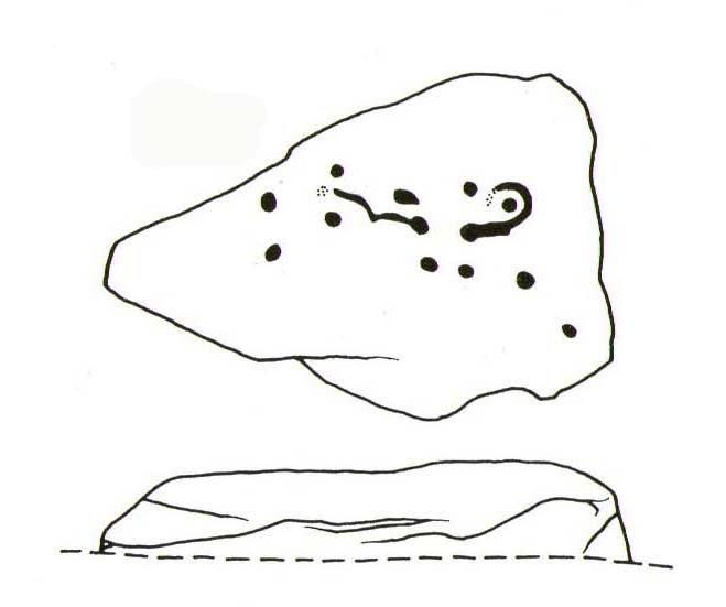
The site was first described by E.A. Cormack (1952) who wrote the following, (slightly edited) piece:
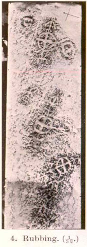
“Examination of the rough and sloping rock surface revealed an interesting group of inscribed figures, confined to an area of about 8 by 2½ feet, four of which included a cross within a circle. The figures are difficult to discern, except when thrown into relief by early morning sunlight, but are clearly demonstrated on a rubbing.
Cormack’s 1952 rubbing of the carving
“The crosses may be described in three groups:
“Group 1 — a) Near the upper edge of the rock is a cross within a circle of 8-inch diameter. The vertical axis of the cross is extended below the circle for 4 inches, resting on an ill-defined rectangular base, and upwards for 5 inches to form an arrow-head with 3-inch barbs. At the junction of the shaft of the arrow with the top of the circle is a pair of contiguous rings of about 1-inch diameter. The cross is deeply cut, to about a half-inch depth, with equal arms 4 inches long and 1 inch broad. The left arm of the cross extends beyond the circle, but this may be due to the circle being slightly excentric in relation to the cross. The lower right quadrant of the circle is marred by a natural crevice in the rock, but careful examination shows that the circle does not cut the right arm of the cross.
b) On each side of this figure is a roughly circular marking, one about 4 inches above and to the left, of 3-inch diameter, and the other 2 inches to the right, of about 5-inch diameter. In each there is an indefinite depression across the centre.
“Group 2 — a) About a foot below and to the right of Group 1 there is a boldly cut cross within a 7-inch circle. Again the vertical arm of the cross is extended above and below the circle, downwards for 5 inches to a curved arrow-head with 4-inch barbs, and upwards as an equal armed 5-inch crosslet above which is a 4-inch circle with the central axis continued through it. (The junction of this axis through the circle with the top of the small cross is slightly angled.) The main cross and circle are cut to fully half an inch in depth and one inch in breadth, but the upper part of the figure is much less distinct.
b) About 8 inches to the left of the upper part of the above figure is a very faintly incised cross within a 2½-inch circle. It is difficult to discern on the rock, but can be seen in the photograph and is very clear on the rubbing. It also appears to have an arrow-head above it.
“Group 3 — a) A foot below and to the right of Group 2 is a clearly cut cross within a 6½-inch circle. A natural cleft in the rock has been used for one axis of the cross, which lies obliquely to the others already described, and this axis terminates in an arrow-head 3 inches below the circle, and another slightly smaller arrow-head is cut 2 inches above the circle; in each case the angle formed by the arrow being towards the circle.
b) Immediately below the last cross is a curious hieroglyph not easy to make out on the rubbing, but clear in the photograph. On an 18-inch vertical axis can be seen from above downwards an arrow-head, an oblique line to the left, a faint 2-inch circle, a transverse stroke, and finally two oblique lines to the right. A natural crevice to the left of the figure rather confuses the picture.”
Ron Morris’ (1981) description wasn’t as detailed and he was initially hesitant about using the site in his rock art survey of the area, as he thought it “most likely to be early christian” in nature and period. He changed his view after talking with an associate at Bergen University, who pointed out that the symbols found here up Glen Lochay were “exactly the same as Norway’s second commonest symbol, the ‘Cross-ring’, which is contemporary with their cup-and-ring series.” Morris described the carvings here as:
“3 ‘cross-rings’ and 7 other rings, some of which have traces of crosses within them. There are also grooves, some extending from a ‘cross’-line to form an ‘arrowhead’, and one group, with ring above, rather resembles a ‘man.’ Largest ring diameter, 20cm (8in) and greatest carving depth, 1cm (½in).”
Examples of the artistic symbolism found at this ‘Duncroisk Crosses Stone’ are scattered throughout western Europe from the Bronze Age period onwards: notably at Dowth and Clonfinloch in Ireland (Brennan 1983; Coffey 1912); Jonathan’s Cave, Fife (Simpson 1867); Valcamonica, Italy (Anati 1961); and all over Norway and Sweden (Coles 2005; Gelling & Davidson 1969; Janson 1966). In more recent times we find these curious symbols etched inside the prehistoric chamber of Ty Illtud (Grinsell 1981) — but these are thought to be later additions. However, the universal nature given to such interconnecting symbols such as those found here is, simply, ritual magick. We find it across the Himalayas, Africa, north and south America – just about everywhere. It would be quite wrong to believe that the presence of an encircled ‘cross’ on this stone relates it to a christian belief system, as such a motif is found in many non- and pre-christian societies with a mythic nature akin to that of the swastika, i.e., of a world unfolding or emerging from a centre-point and the arms of the ‘cross’ outwards defining the directions and boundaries of any specified cosmology: be it landscape, heavens, spirit worlds, pregnant belly, etc.
Solar cross? Eye? Vulva?…or dancing human figure?
As Cormack (1952) described, the respective groups of carvings are integrally linked by an interconnecting line that joins the symbols in the respective groups to the other symbols. The fact that the connecting ‘lines’ are natural is meaningful in the relationship between humans and Nature; but moreover, the connecting line linking the symbols strongly implies sequential reasoning and magickal import. Indeed, these three distinct clusters (see Cormack’s rubbing) are functionally akin to magickal sigils, examples of which are found across the ancient and modern world. This is a notion that must be given serious consideration as a function in the carved stone of ‘Duncroisk 4’. Equally we can see in one section of the carving what may be a dancing human figurine, very much like rock carvings found elsewhere in Europe and beyond.
Both Erich Neumann (1973) and Alex Marshack (1972), for slightly different reasons, would also see the images carved here as early expressions of human development: either through i) the emergence of archetypal patterns and the interpretative interplay of the ego, or ii) the intellectual evolution of magickal appliance, whereby imagery and human action are recognized as meaningful in a wider natural sense. In the case of Duncroisk 4 it would more likely possess magickal import, as symbols were much more than ‘art’ and possessed meaning on several interconnecting levels, one of which being ritual function — an element that modern archaeology is slowly learning to incorporate into its analyses.
Dancing Siberian ShamanDancing shaman figure?
A more in-depth comparative essay is really needed to give a clearer exposition defining the nature of this carving… My personal view is that the carving represents, not some solar design, but one of Britain’s earliest artistic examples of human beings, in this case dancing and beating a drum or bodhran. It may indeed be the earliest pictorial example of a bodhran in the country. I’d say so. There is also the distinct possibility that the dancing figure is a shaman. We have many petroglyphs from all over the world that highlight such a character, integral to all early cultures—and this is as likely a contender as any for such a figure. (see Gough 1999; Whitley 2000, etc) It may however, be a warrior with a shield. You see the problems we can have with these damn carvings! 🙂
Folklore
This carved rock is said by local people to have been where a ‘Celtic’ saint delivered sermons to the heathen populace. The saint concerned is likely to be the one who tradition tells gave his name to the small glen immediately across the track from here: St. Charmaig. Halfway up the small glen is a small cave, barely accessible, with untouched remains of dried roots and other elements of human habitation therein. A few hundred yards to the north in old Finn’s Glen, is the forgotten Waterfall of the Oracle which sometimes isn’t even there!
References:
Anati, Emmanuel, Camonica Valley, Alfred Knopf: New York 1961.
Brennan, Martin, The Stars and the Stones: Ancient Art and Astronomy in Ireland, Thames & Hudson: London 1983.
Coffey, George, New Grange and other Incised Tumuli in Ireland, Dolphin: Poole 1977.
Coles, John, Shadows of a Northern Past: Rock Carvings of Bohuslan and Ostfold, Oxbow: Oxford 2005.
Grinsell, Leslie V., “The Later History of Ty Illtud,” in Archaeologia Cambrensis, 131, 1981.
Janson, Sverker & Westman, David, Rock-Carvings at Fiskeby, Esselte AB: Stockholm 1966.
Kuhn, Herbert, The Rock Pictures of Europe, Sidgwick & Jackson: London 1956.
Marshack, Alexander, The Roots of Civilization: The Cognitive Beginnings of Man’s First Art, Symbol and Notation, Weidenfeld & Nicolson: London 1972.
Morris, Ronald W.B., The Prehistoric Rock Art of Southern Scotland, BAR 86: Oxford 1981.Neumann, Erich, The Origins and History of Consciousness, Bollingen Princeton University Press: New York 1973.
Royal Commission on the Ancient & Historical Monuments of Scotland, Archaeological Sites and Monuments of Stirling District, Central Region, Society of Antiquaries of Scotland 1979.
Simpson, James, Archaic Sculpturings of Cups, Circles, etc., Upon Stones and Rocks in Scotland, England and other Countries, Edmonston & Douglas: Edinburgh 1867.
Whitley, D.S., The Art of the Shaman: Rock Art of California, University of Utah Press 2000.
Follow the same directions to reach the superb Badger Stone carving, and from here take the footpath that runs downhill. You’ll cross another footpath about 100 yards down the moor, but just keep walking down the path and you’ll notice the small copse of woods ahead of you. As the footpath begins to swerve roughly away, northeast, heading away from the said woodland, keep your eyes peeled on your left for a reasonably large but flattish rock close to the ground (in summer it’s surrounded by bracken) about 75 yards away. That’s your target!
Archaeology & History
Of the hundreds of cup-and-ring stones on Ilkley Moor and district, this is one of my personal favourites! I first visited the stone in 1977 as a young teenager and was mightily impressed by the unusual nature of the design here — and that impression still remains. Aswell as possessing the usual cups and rings, the Barmishaw Stone is one of just a few rocks also possessing a sort of ‘ladder’ design or linear pattern within the overall carving: an insignia echoed on the nearby Willie Hall Wood carving, the Piper Stone, and also on the Panorama Stones. As with the ‘ladders’ on the Panorama carving, those found here at Barmishaw are very eroded and are increasingly difficult to see during the daytime (the best time to notice them is usually around sunrise or sunset, and particularly when the rock itself is wet).
The carving has been described many times, albeit briefly, by a number of writers. In John Hedges (1986) fine survey he said the following:
“Medium sized flat-topped rock…fairly smooth grit, sloping slightly east to west, covered with carvings, some of which are very worn. Slanting sunshine needed to detect them. About twenty-four cups, at least nine with rings or incomplete rings, two with multiple grooves half round and continuing straight down, one of them incorporating ‘ladder.’ Five other ‘ladders’ – in a good light. Cups mostly deep and clear.” A few years later, Boughey & Vickerman (2003) echoed much of Mr Hedges description, though noted that of the 24 cups with their rings, one possessed a triple ring.
Alan Davies’ illustration
Like so many cup-and-ring stones, they have given rise to hosts of fascinating theories and ideas — one of which is based on mathematics and metrology. In the 1980s, Alan Davies (1983, 1988) surveyed the Barmishaw Stone — and other carvings on Ilkley Moor — to explore the possibility that the cups and rings were laid out according to a basic unit of measure, the Megalithic Inch (MI), as proposed by Alexander Thom some years earlier. Although Davies’ work showed that such a primary unit of measure wasn’t to be found universally, his research at the Barmishaw Stone indicated “significant evidence for quanta of…3 MI,” although this occurred “when the analysis is restricted to only ringed cups.” Despite this, Davies thought that the existence of the Megalithic Inch was evident in this and other carvings on the moors, stating that:
“The repeated emergence of the significance of ringed cups, and the fact that all putative quanta seem to bear a simple numeric relation to each other do not seem to be coincidental.”
Although it has to be said that the selectivity of data in Davies’ research is more indicative that the Megalithic Inches in the the carvings was due, neither to chance nor mathematics, but more that the implements used to carve the rocks and the size of the hands of the people doing the carvings was pretty uniform and so, as a result, would give an obvious window of numeric similarities that can easily be mistaken as a deliberate metrology. These simplistic factors need assessing. In modern trials that we’ve done carving cup-markings, we’ve found them to be of similar size to those carved in prehistoric times—as you’d expect.
Barmishaw Stone (after Hedges, 1986)Barmishaw stone (Cowling 1946)
The ladder motif central to this carving may have related to early religious and ritual events here. Across the world, indigenous cultures commonly relate the ‘ladder’ to be a symbol of ascension, both by shamans, mystics and during rites of passage. The symbol represents the journey of the soul to and from supernatural realms. To discount this possibility at the Barmishaw Stone would be shortsighted.
The carving was very probably painted when our neolithic ancestors gathered here, much as Australian aborigines still do to their carvings using lichens and other plant dyes, with the respective ladders and lines changing colour where movements between worlds or shifts of attendant spirit occurred. By virtue of the its very name, I consider this rock to have been considerably important; the “ghost” aspect to barmishaw being a typically misconstrued aspect of ‘spirit’.
Folklore
This excellent cup-and-ring marked stone probably derives its name from the old dialect words “barm i’ t’ shaw”, meaning “ghost in the wood” stone. Whatever guise the attendant spirit of this rock may have had has long since been forgotten; though spectral accounts from the beginning of the nineteenth century until modern times may give us clues. There have been several reports of green-coloured elemental creatures around the area between here and the White Wells sacred spring a short distance to the east. The most recent account, from 1987, took on the modern mythic form of a little green man from space, with attendant UFO to boot! The Barmishaw Hole nearby was a place where faerie-folk used to live. Excesses of geological faulting and water makes the magickal nature of this place particularly potent.
References:
Allen, J. Romilly, “The Prehistoric Rock Sculptures of Ilkley,” in Journal of the British Archaeological Association, volume 35, 1879.
Allen, J. Romilly, “Notice of Sculptured Rocks near Ilkley,” in Journal of the British Archaeological Association, volume 38, 1882.
Bennett, Paul, “Cup-and-Ring Art”, in Towards 2012, volume 4, pp.83-92, 1998.
Bennett, Paul, The Old Stones of Elmet, Capall Bann: Milverton 2001.
Boughey, Keith & Vickerman, E.A., Prehistoric Rock Art of the West Riding, WYAS: Wakefield 2003.
Cowling, E.T., ‘A Classification of West Yorkshire Cup and Ring Stones,’ in Yorkshire Archaeological Journal 1940.
Cowling, E.T., Rombald’s Way: A Prehistory of Mid-Wharfedale, William Walker: Otley 1946.
Davis, Alan, ‘The Metrology of Cup & Ring Carvings near Ilkley in Yorkshire,’ Science Journal 25, 1983.
Davies, Alan, ‘The Metrology of Cup and Ring Carvings,’ in Ruggles, C., Records in Stone, Cambridge University Press 1988.
Eliade, Mircea, Patterns in Comparative Religion, Sheed & Ward: London 1958.
Hedges, John (ed.), The Carved Rocks on Rombalds Moor, WYMCC: Wakefield 1986.
Wright, Joseph, The English Dialect Dictionary – volume 1, Henry Frowde: Oxford 1905.
John Dixon took a bunch of us on a pleasant amble here via the Fair Oak Circle site. From Fair Oak, go round the back of the farm and past the small cluster of hidden cottages, then bear right down the dirt-track and up the slope, then cross the field in front of you, going over the stile, following the footpath round the eastern edge of the slightly limestone New Laund Hill, and down again, thru the gate. From here, head diagonally across the field 150 yards towards the fencing at the woodland edge. Over the fence, into the trees, head halfway down the steep-ish slope and keep your eyes peeled for the rocky outcrop nearly halfway down. Alternatively, an easier way here is apparently from the Inn at Whitewell. Go across the river via the stepping stones (or wade!) and follow the footpath uphill towards a farm, where you’ll find a large steel gate on the left that leads into the woods. Here there are 2 paths: follow the higher of the two until it starts bearing to the right. Once here, look up the hill to the right you’ll see the rock outcrop. The caves are there!
Archaeology & History
Smaller Fairy Hole
There are at least 3 caves here, close to each other along the edge of the small footpath a few yards apart. The small rounded entrance of the northernmost one (photo, right) is reported by English Heritage to have had no human remains found therein, but further investigation is required here. The main cave however is where intriguing prehistoric finds were located. It appears that the entrance was deliberately built-up and blocked by stone walling a few yards inwards, giving the remains found therein a state of protection and sanctity. Writer and historian John Dixon (2004) tells what was in the cave:
“In 1946, an excavation was carried out on the site by the archaeologist Reginald C. Musson. In front of the larger cave is a flat platform on which evidence of Bronze Age daily life was found. This included animal bones, a pebble pounder (used to extract marrow from bones) and shards of a food vessel.
“All that survived of this tripartite collared urn was a large rim-collar shard, two fragments displaying neck/shoulder/body elements and five smaller pieces, probably from the base of the body. This is the only collared urn to have been found in a cave in Lancashire. Its tripartite Pennine form assigns it to an early Bronze Age date.”
The main Fairy HolePlan of cave chamber (after J.Dixon 2004)
The artificial walled entrance may not merely have been an ingredient giving sanctity to the place, but this could well have been a site for ritual shamanic practices, including prolonged rites of passage and death rituals (authentic ones, not the modern pagan nonsense). The ‘ritual death’ elements are highly probable here for, as John Michell (1975) told, caverns and crevasses are “most responsive to the necromancer’s invocation”. It’s geomancy, spirit association and the archaeological finds therein are strongly suggestive of this usage. (Eliade 1989, 1995; Maringer 1960, etc) Bearing this in mind, it is of some concern regarding the individual who thought it wise to spray-paint his name against the wall of the cave entrance (see photo); for many are those even in these days of shallow minds who fall prey to the car-crashes and creeping madness brought upon themselves by desecrating ancestral sites of ritual magick. It would be intriguing to keep a prolonged eye on the ‘Forsh’ who painted his ego in this cave of dead spirits…
Folklore
Not surprisingly, the little people hold legend here. Jessica Lofthouse (1946) found tales of these ancient peoples in several places close by, but at the Fairy Caves specifically,
“everyone knew that these little caves in the limestone at Whitewell were the homes of the little folk.”
…And in relation to the ingredient mentioned above, about ritual use of the cave in ancient times: are there any serious ritual magickians who’ve spent time working in this cave, overnight or longer, and who can let us know of their encounters here? (long shot, I know – but it’s worth asking, considering the probable use of the place) Or perhaps spontaneous encounters of other people here…
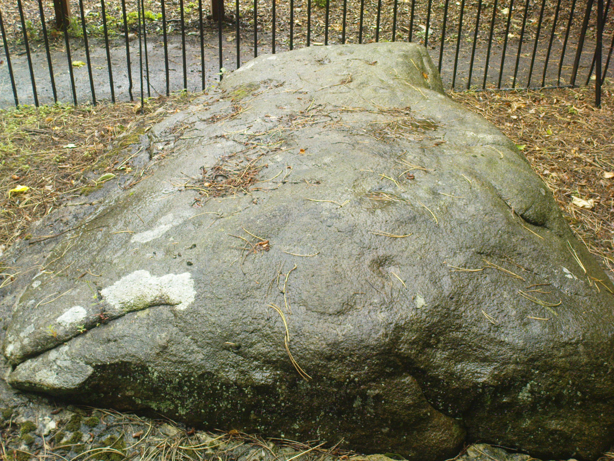
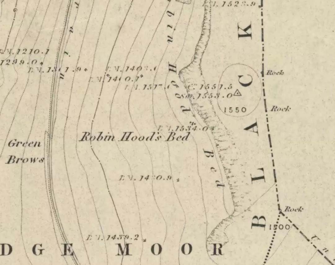
Follow the same directions to get to the Aiggin Stone. Once here, go over the stile by the fence opposite towards the great geological ridge less than half-a-mile south. Head for the triangulation pillar right on the top of the ridge, and there, about 20 yards past it, higher-up than the triangulation pillar at the very top of Blackstone Edge, is Robin Hood’s legendary stone bed!
Archaeology & History
Robin Hoods Bed, looking north
There’s very little of archaeological interest known up here, save a mass of flints and scrapers that have been found scattering the moorland heights hereby, from the mesolithic period onwards. But we have a relative lack of neolithic to Iron Age remains — officially anyhow! A possible standing stone can be found a few hundred yards south, but there’s little else.
The rock that’s given its name to Robin Hood’s Bed overlooks the very edge of the ridge, detached from the main section, with a large and very curious nature-worn ‘bed’ on its very crown, more than 4 feet wide and about 7 feet long, into which one comfortably lays. It was named in the boundary records of the township of Rishworth in 1836, where it describes other historical stones, saying:
“thence under Robin Hood’s Bed to a stone marked ‘W.S.G.S. 1742, 1770, 1792, and the following figures and letters, ‘1826 I.L.S.'”
Folklore
This enormous millstone grit boulder, sitting 1550 feet upon the high moors is, according to legend, a place where our famous legendary outlaw once slept. Whilst sleeping here, some of his followers were said to have kept guard and looked over him.
Robin Hood’s Bed, from below
A rather odd piece of folklore recited by Jessica Lofthouse (1976) is that “no winds ever blow” at Robin Hood’s Bed, who then went on to tell of the time she visited the place. Walking along the rocky ridge where the stone bed is found, the winds were such that “we had almost been blown over the edge,” until just a few hundred yards further when they eventually reached the fabled site, Nature granted them a sudden calmness unknown to all the high moorlands around, affirming the curious folklore.
The ceremonial stone ‘bed’
Robin Hood’s Bed itself was undeniably an important ceremonial site for both rites of passage and ritual magick to our indigenous ancestors. The place screams of it! It also seems very likely that the hero figure of Robin Hood replaced an earlier mythological character, akin to the fabled female creation deity, the cailleach, found commonly in more northern and Irish climes, whose echoes can still be found around our Pennine hills. For we find that Robin Hood was said to have taken a large boulder from here and with a mighty heave threw it six miles across the landscape due west into the setting sun, where it eventually landed at Monstone Edge, near Rochdale! Local people were so astounded at this feat that the stone was given the name of Robin Hood’s Quoit.
7ft tall natural standing stone
The old place-name authority Eilert Ekwall (1922) related the folklore that the giant ridge of Blackstone Edge “is said to refer to a boundary stone between Yorkshire and Lancashire.” Which may be the curious upright standing stone, more than 7 feet tall, less than 50 yards NNE which gives a very distinct impression of having been deliberately stood upright, amidst this mass of loose geological droppings! It would be helpful if there was a geologist in the house who could tell us decisively one way or the other…
Another etymological possibility that has been posited relates to the word ‘bed’ at this site. Ordinarily it would be sensible to attach the word to the great stone ‘bed’ atop of the poised boulder. But with the attached legends symptomatic of prehistoric monuments, it would not be improper to highlight that the old Welsh word ‘bedd‘ (a place-name element that is not uncommon in Lancashire) means, “a grave or tomb”. And this site would be ideal for such an old prehistoric cairn…
References:
Bennett, Paul, The Old Stones of Elmet, Capall Bann: Milverton 2001.
Ekwall, E., The Place-Names of Lancashire, Manchester University Press 1922.
Lofthouse, Jessica, North Country Folklore, Hale: London 1976.
Smith, A.H., The Place-Names of the West Riding of Yorkshire – volume 3, Cambridge University Press 1961.
The Nanny Howe burial mound was one of a group of at least three tumuli that could be found on what is now the wooded hilltop of Coate Moor, a mile east of Great Ayton. Large and conspicuous in previous centuries, the site was described briefly in Elgee’s (1933) archaeological survey as being in association with a prehistoric settlement, which itself appears to have long since succumbed to forestation. An essay on the state of this apparent Bronze Age burial mound was written by Mr Hayes (1966), who told us:
“The kerb of the barrow was exposed and noticed by J.N Grayson whilst excavations were in progress on Great Ayton Moor. S.V. Morris, A.N. Pacitto and the writer examined the site. It was a cairn of about 30ft diameter and 3ft high in the centre, with a strong kerb of stones set on edge of 25ft diameter. Its construction, of massive stones was similar to the chambered cairn on Great Ayton Moor, one mile to the north, and very like the food vessel-urn tumulus on Danby Rigg which also had a kerb of the same diameter…
“When the heather and turf were removed on the south-east side of Nanny Howe, a mass of cremated bones with part of the rim and side of a typical Iron Age ‘B’ jar were found only 6-9in under the turf. This was clearly a secondary burial long after the cairn was built. The sherd may have been a token offering, but more probably the remainder of the pot so near the surface of the mound had been eroded. No other secondary burial was found, although almost all the cairn was removed.
“Under large boulders in the central area was a shallow pit or depression… Only minute specks of charcoal and some small burnt stones distinguished its filling from natural sand. It was about 3ft in diameter and not more than 9in deep… In it were the broken sherds, more than 80 in number, of a beaker… There were no signs of bones or cremation, although presumably a contracted skeleton had accompanied the beaker. In the acid sand all bones would perish quickly… No other relics were found in the cairn.”
To which Mr Hayes and his team concluded the Nanny Howe tomb was an example of a typical “beaker burial” as they used to like calling them, set within a ring of stones over which the cairn was piled; and long after this, seemingly the Iron Age, a secondary cremation was inserted.
Folklore
Folklore ascribed the entire settlement here to have heathen origins, with Nanny Howe also standing out with folklore of its own. As Mr & Mrs Elgee (1933) wrote:
“Half a mile east of Captain Cook’s monument…on Easby Moor is the Devil’s Court, where, according to tradition, witches congregated under the presidency of their lord and master. We therefore examined the Court and found what we expected, a typical moorland Bronze Age settlement site, with stone-walled enclosures, shallow pits, flint implements and many barrows, one of which is named Nanny Howe, after a famous witch, it is said, who also frequented Nanny Nook, a right-angled bend in a stone wall near Wayworth Farm, Commondale, marking another settlement site.”
Another tale of this legendary witch was narrated by folklorist and historian Richard Blakeborough in one of his many tomes, where he told:
“Again, old people of Great Ayton still aver that on a certain night a once noted witch, Nanny Howe, may be seen riding astride on a broomstick over Howe Wood just at midnight. This witch, so mounted, is said once to have chased the devil for miles — on this occasion the two must have fallen out ; perhaps at that time honest folk got their due. Howe Wood is near Kildale.”
Whatever the source of such stories, the respective archaeologists of Elgee and Hayes wondered if they derived from some pre-christian rites and events. Hayes asked:
“Was the person interred in Nanny Howe a famous witch? Or were the witch and the devil legends connected with the site faint echoes of ceremonials and rites held here?”
It would seem likely that the local peasant communities hereby were, thankfully, not inflicted with the empty spirituality of the christian cult when it tried taming the souls of the villagers living in and around here. The folklore would seem to reflect simple peasant gatherings and celebrations, frowned upon by those weird clergy-folk, no doubt striving to get the local children into their more demonic pastimes…
References:
Blakeborough, Richard, Wit, Character, Folklore and Customs of the North Riding of Yorkshire, W. Rapp: Saltburn 1911.
Elgee, Frank & Harriet, The Archaeology of Yorkshire, 1933.
Gutch, Mrs E., Examples of Printed Folklore Concerning the North Riding of Yorkshire, David Nutt: London 1899.
Hayes, R.H., “Nanny Howe, Coate Moor, Cleveland,” in Yorkshire Archaeological Journal, part 164, 1966.


")
")
")


")