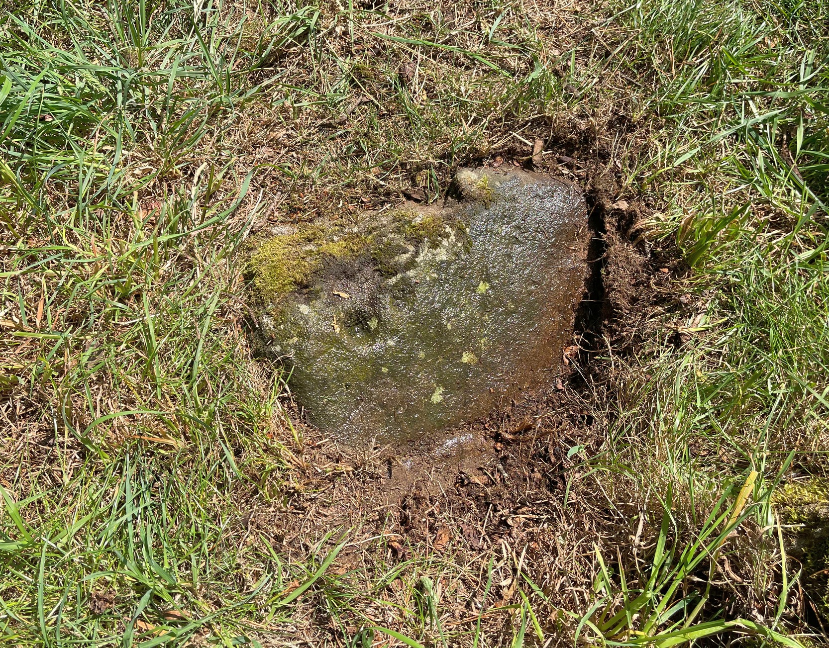
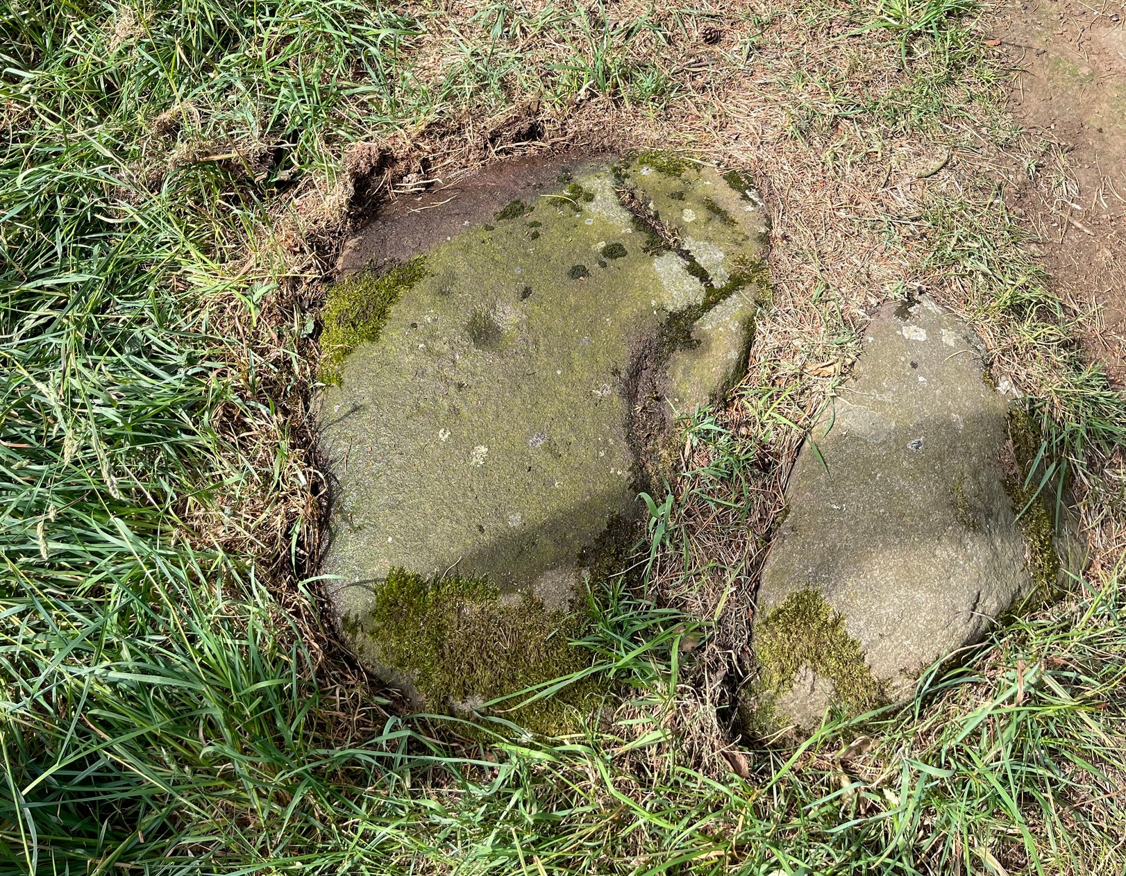
Found barely 12 inches east of the Tormain (7) carving, this ‘cup-marked stone’ is another somewhat dubious design in the Tormain cluster, but which I’m adding here for the sake of completeness. It’s designated as authentic by the Scottish Rock Art Project—but I’m not convinced. Consisting of just two cup-marks, Romilly Allen (1882) was the first to notice them and described them respectively as, “one 1 inch in diameter and the other 1½ inch across.” The smaller of the two, I’m pretty sure, is geophysical in nature.
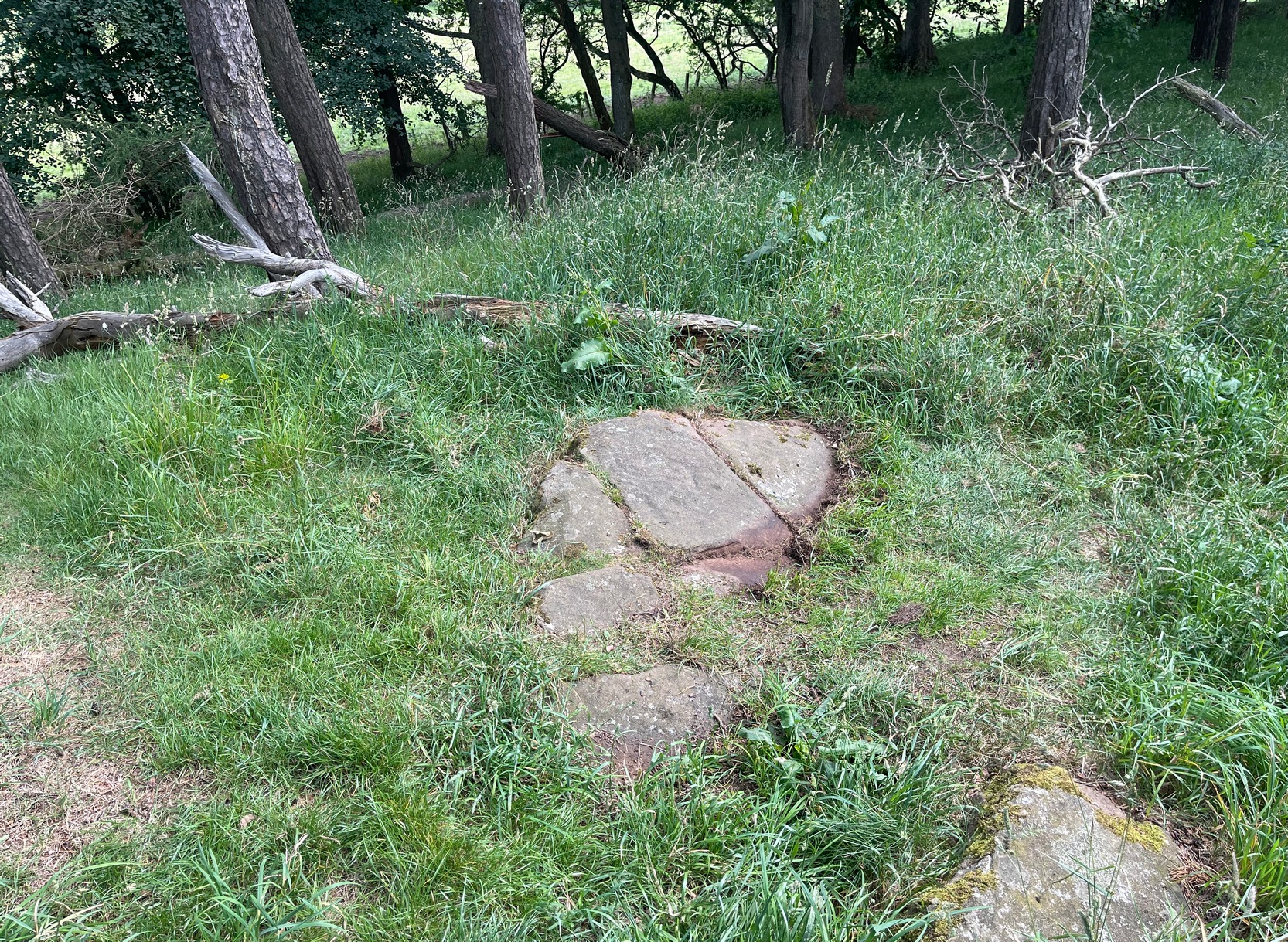
Two or three yards from the impressive Tormain (1) carving you’ll see this elongated stone, cracked into three separate pieces. Its sloping southeastern section is possessed of a single cup-marking, an inch or two across, which, if you found it anywhere else, you’d just shrug your shoulders and walk on by. It’s only due to this stones proximity to the more impressive carvings that it’s received any attention (ordinarily I wouldn’t even have added this to the database). It was first noticed when Romilly Allen (1882) visited the area. The Royal Commission’s (1929) survey of Tormain Hill mentioned “a single cup on one boulder,” but didn’t specify which of the three examples up here they were referring to.
Royal Commission Ancient & Historical Monuments of Scotland, Inventory of Monuments and Constructions in the Counties of Midlothian and West Lothian, HMSO: Edinburgh 1929.
Cup-Marked Stone (dubious): OS Grid Reference – NT 12908 69669
Also Known as:
Tormain ‘F’ (Allen 1882)
Archaeology & History
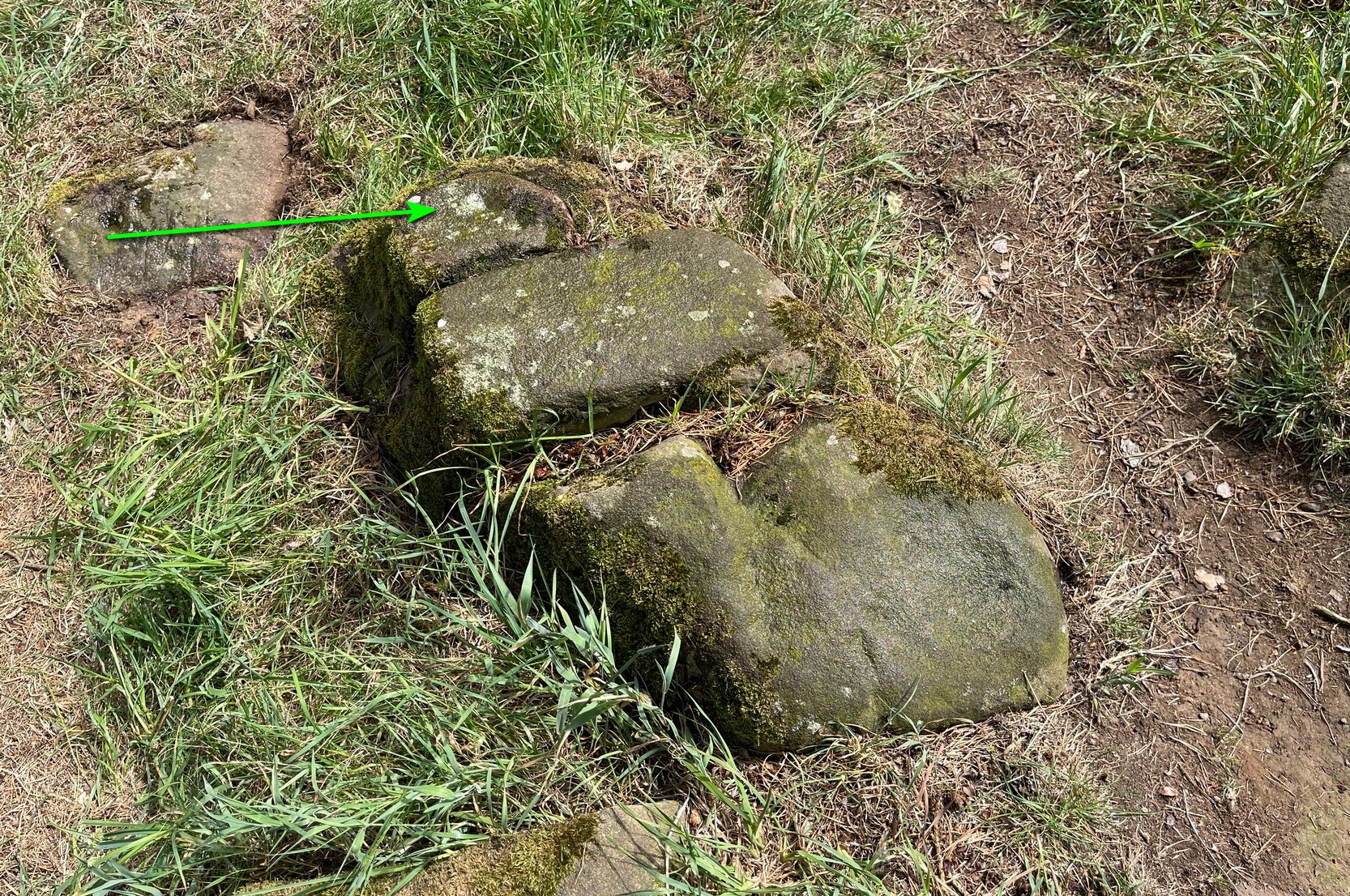
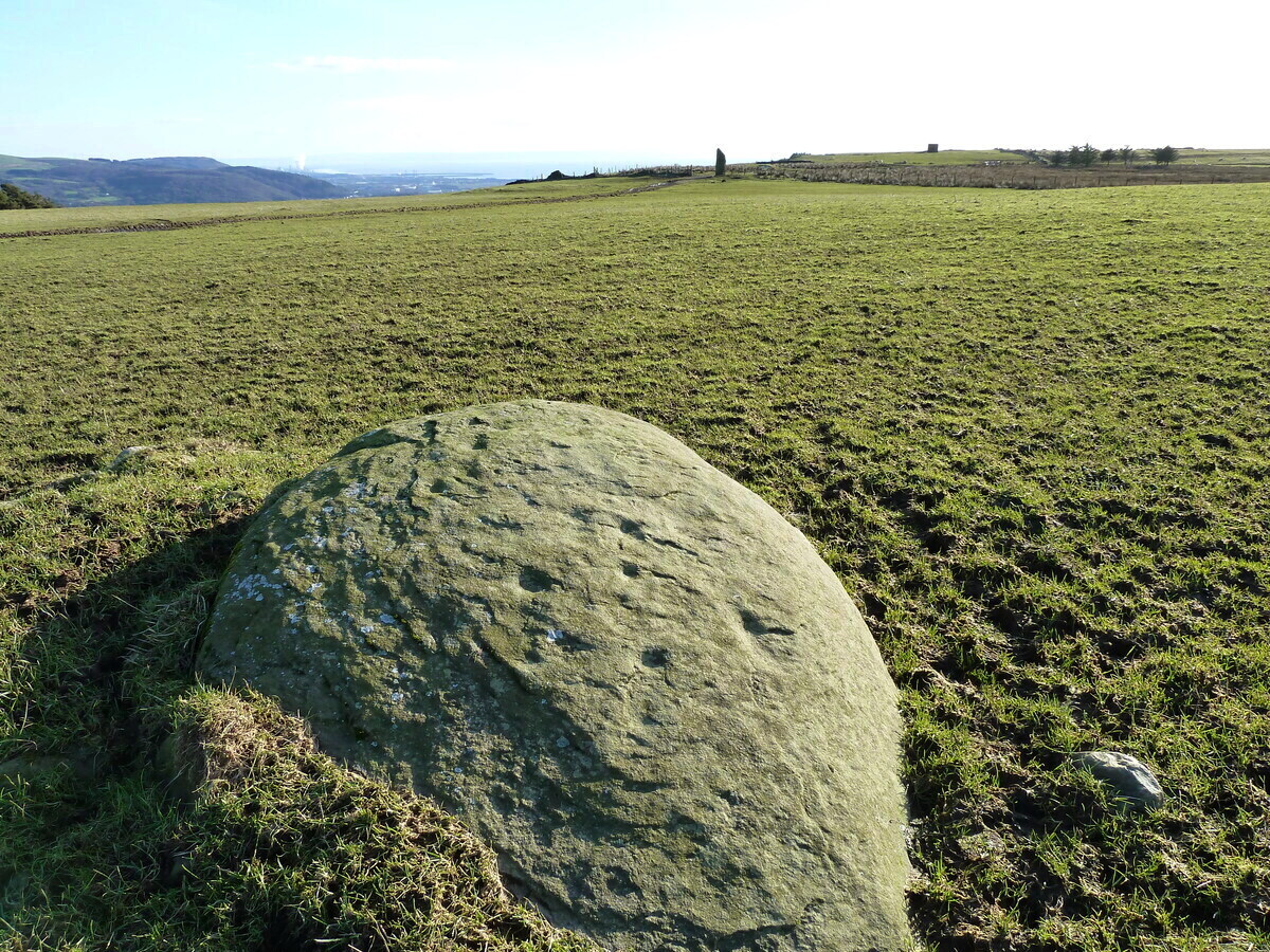
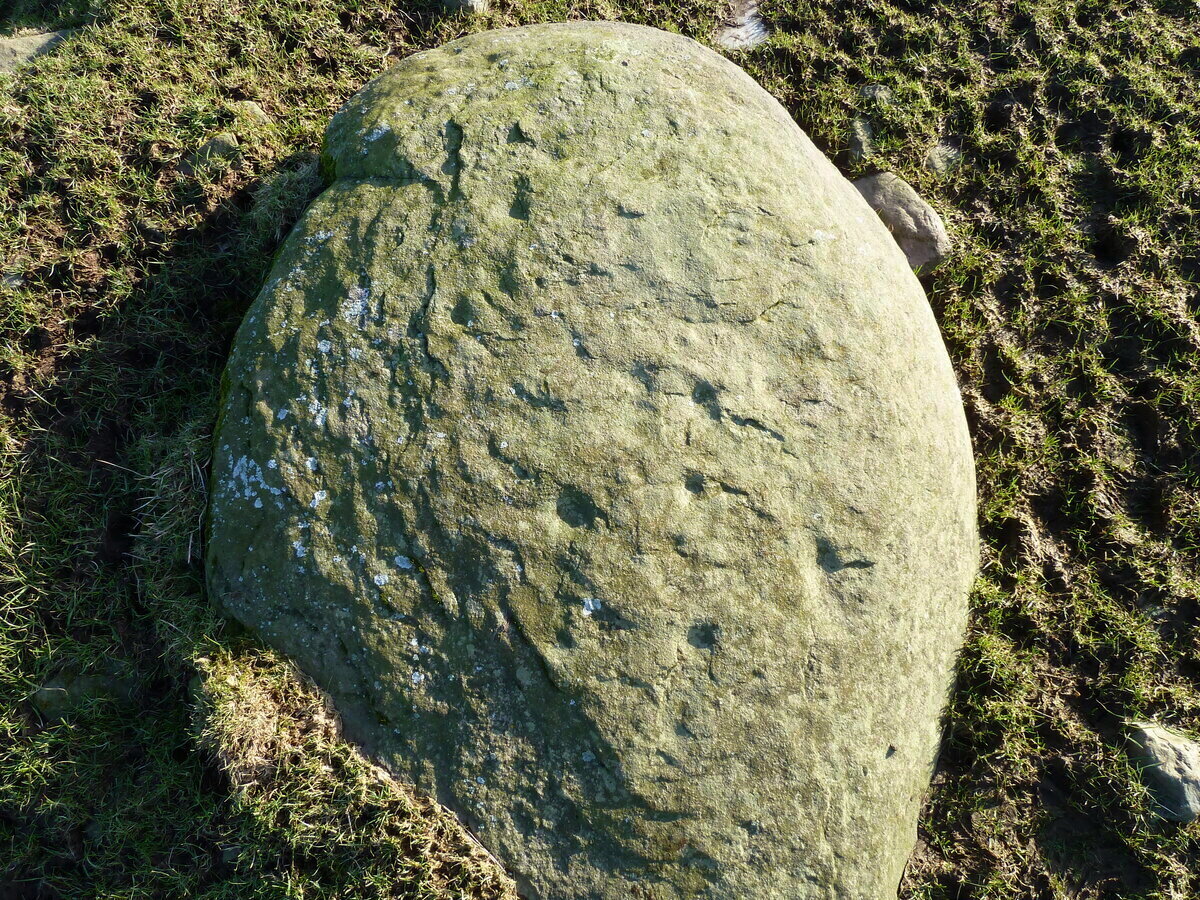
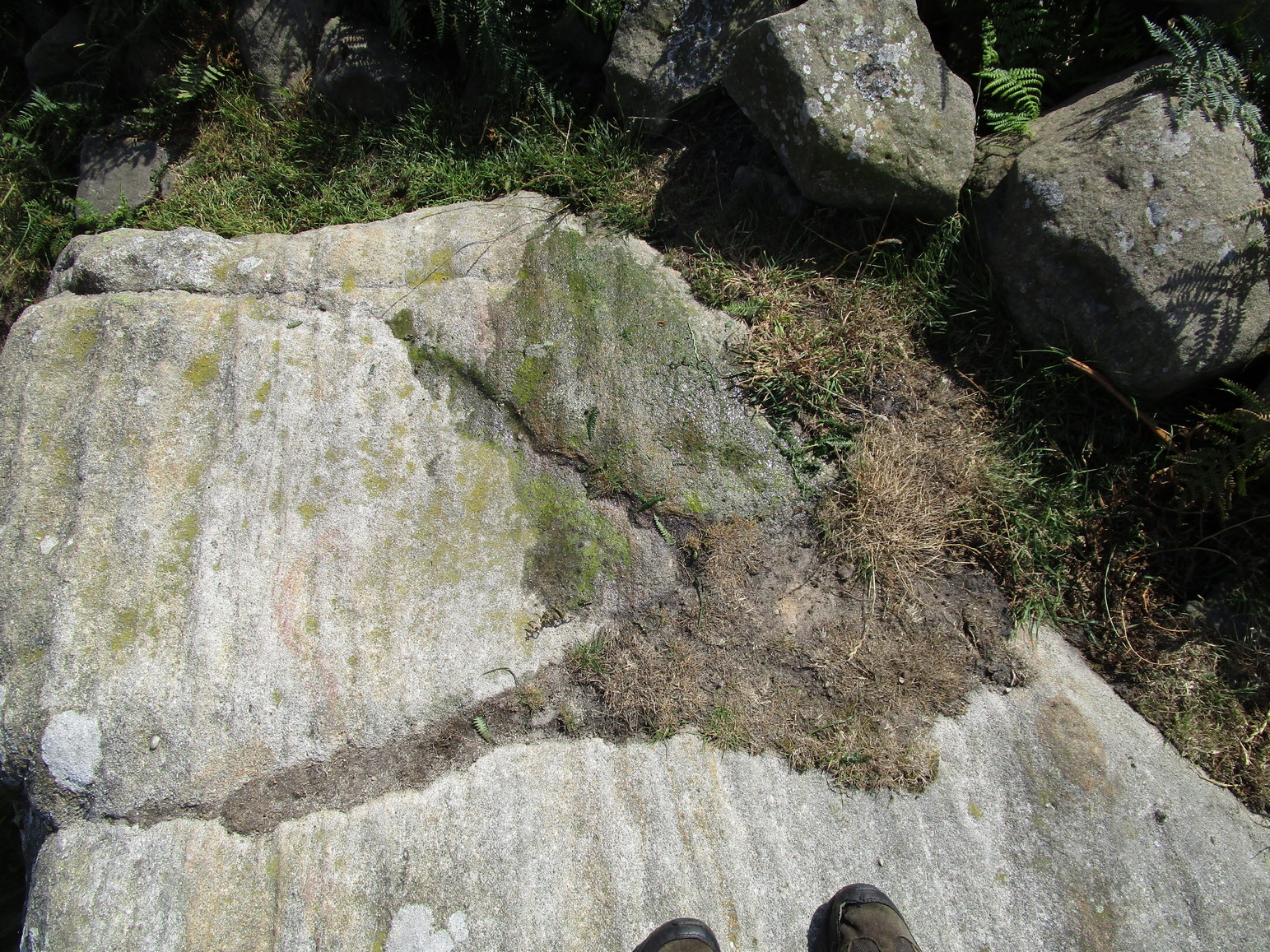
Tormain 6 (left of centre)
On the small rock right next to the plain Tormain (7) cup-marking is this, the least impressive and least likely candidate as an authentic cup-marked stone. Its existence was first added to the Tormain Hill cluster by Romilly Allen (1882) following his visit here. The carving has been maintained as the real deal, even by the Scottish Rock Art Project, but I have severe doubts as to the archaic nature of this marking. It seems to be geophysical in nature and there are innumerable marks such as the one found here that I’ve dismissed on my countless petroglyphic excursions over the years. I’d like to be wrong though. (the “carving” is so unimpressive that I didn’t even waste time taking a decent photo of it —so my apologies to those who wanted greater image clarity) When the Royal Commission (1929) surveyed Tormain Hill, they mentioned “a single cup on one boulder,” but gave no indication which of the three single cup-marked stones they meant.
Royal Commission Ancient & Historical Monuments of Scotland, Inventory of Monuments and Constructions in the Counties of Midlothian and West Lothian, HMSO: Edinburgh 1929.
Follow the same directions to get to the Tormain (1) carving, but take a few steps backwards from it and it’s on a small flat earthfast stone to your right (west). You’ll see it.
Archaeology & History
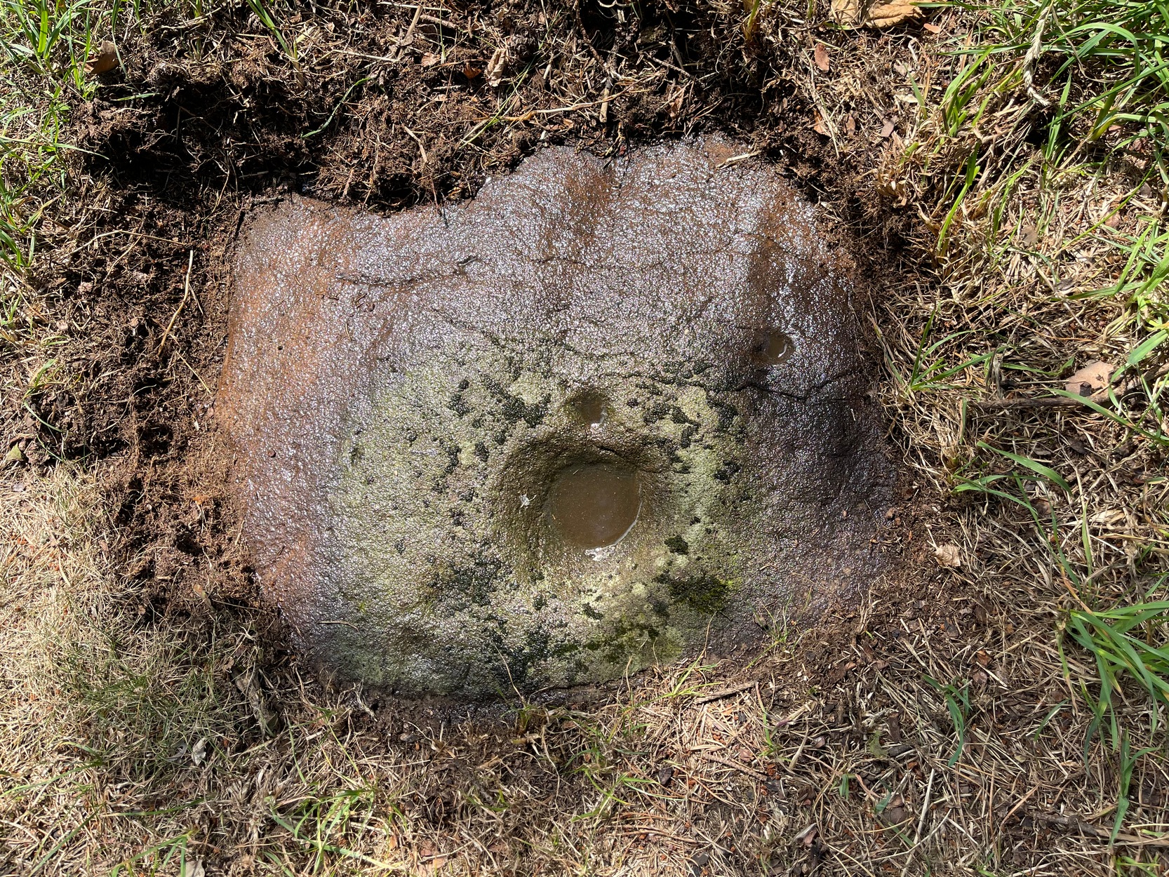
Tormain bullaun stone
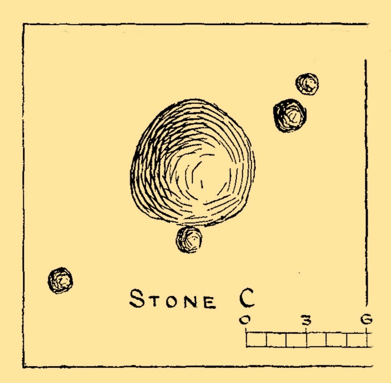
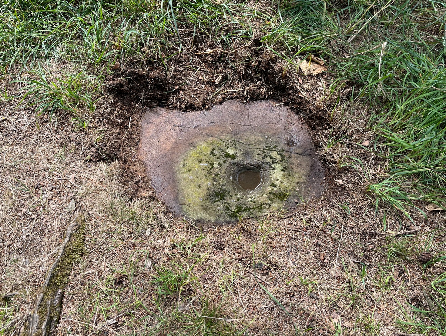
Just a stride or so away (north) from the dubious Tormain (2) cup-marking we find a much more likely prehistoric contender in front of us. It’s notably different from the others on the hill in that it possesses a very large wide and deep ‘cup mark’ which, if it was found in Ireland, would undoubtedly be classed as a bullaun stone. That was the first thing I exclaimed to myself when I clapped eyes on it! A bullaun can be a man-made or natural hollow or basin cut into outcropping rock, boulders or small portable stones and used for various pragmatic and ritual purposes – many with traditions and folklore attached. Sadly, no such folklore is remembered here.
There are four other smaller standard sized cup-marks, at various distances from the primary bullaun, one of which may be Nature’s handiwork. They were illustrated by the great Romilly Allen (1882) when he first wrote about the carving. One of the cups may have a faint carved line running from it, but this would require the attention of the computer imagery dudes to confirm or deny this. It wasn’t seen by Allen, who simply said of it:
“The carvings on it consist of a bowl-shaped depression, 6 inches in diameter and 2 inches deep, and four cups near it varying in diameter from 1 to 1½ inches.”
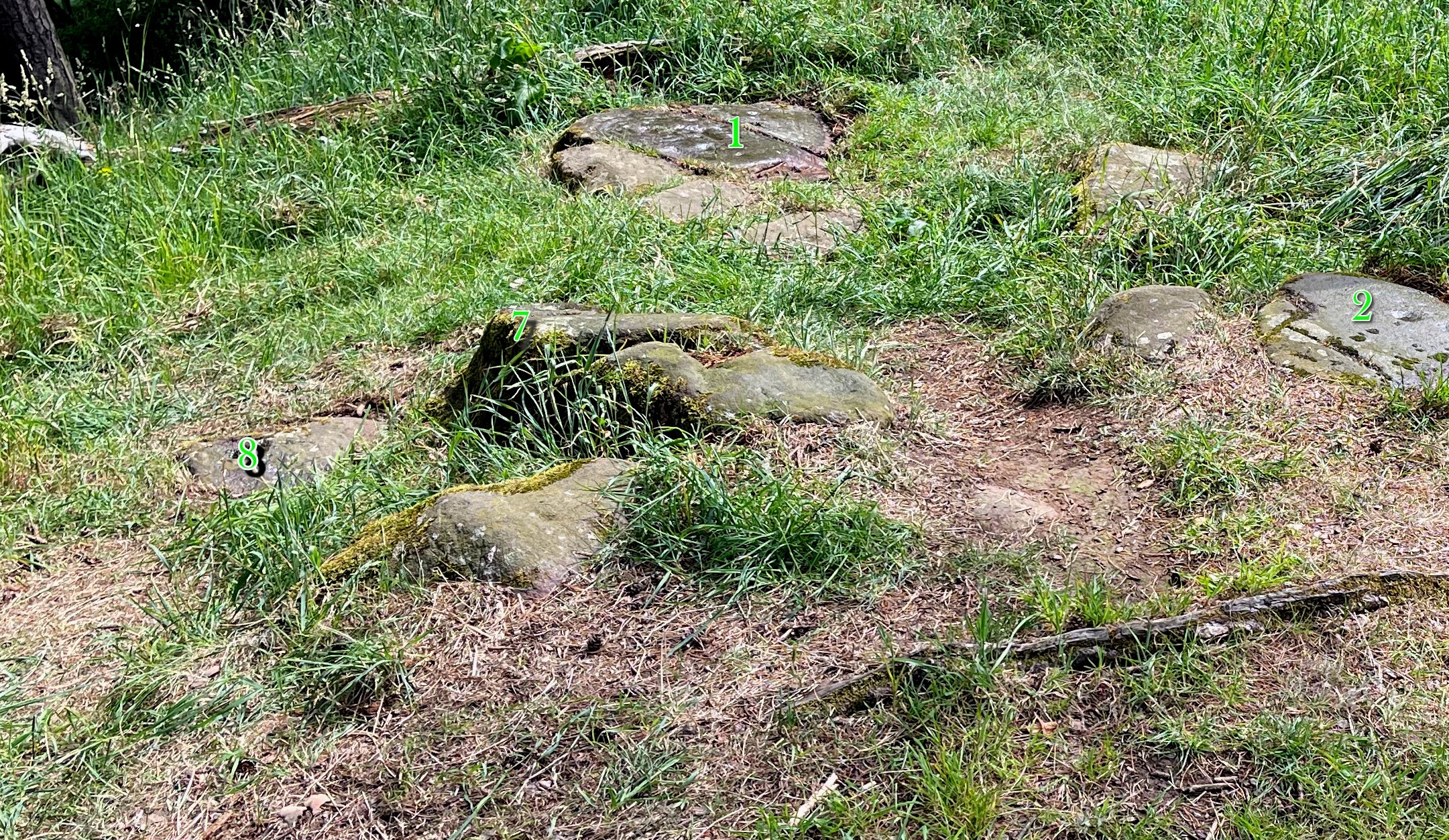
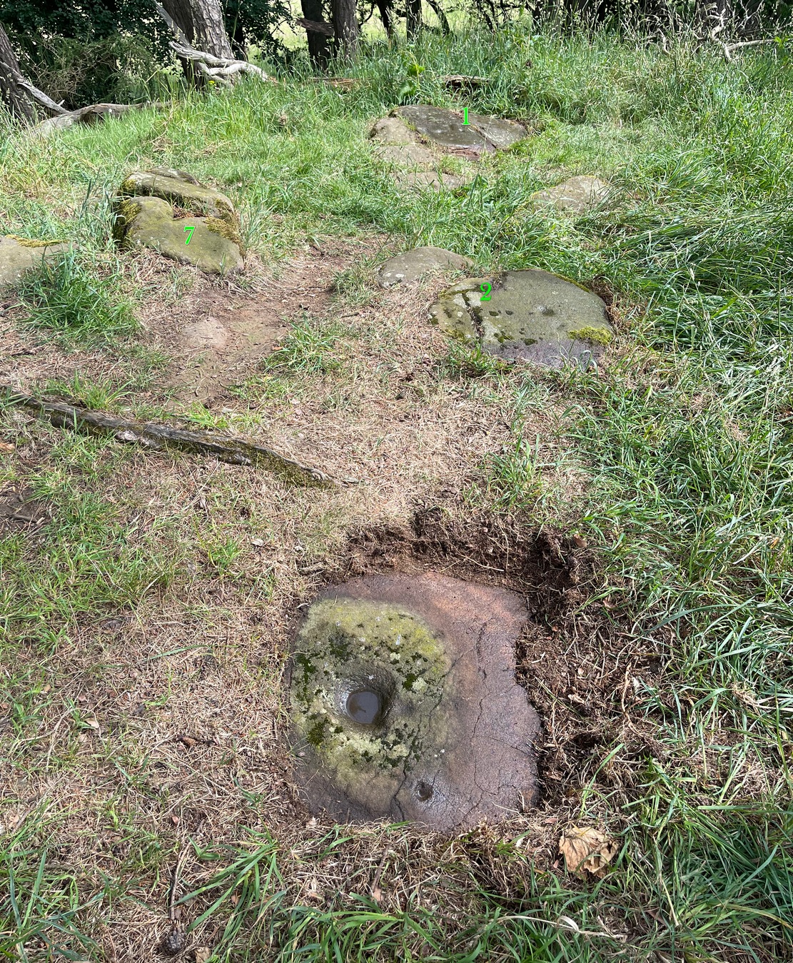
Tormain 3 carvingTormain 3 (with 1, 2 & 7 marked)
The fact that bullauns possess a number of practical uses implies the large ‘bowl’ may have been used in a pragmatic sense for something, with the proximity of the impressive Tormain (1) carving just yards away almost appealing for ceremonial association of one form or another. We find similar bullaun/petroglyph associations at a number of other recognized rock art sites: the Mixing Stone in North Yorkshire being just one example. Large bowl-shaped hollows have been used in some cultures like mortar and pestles to macerate herbs, used in medicines and paints, both of which may have been applicable here.
Best approached from Ratho village, head up Main Street towards Bonnington Mains. Shortly after the last road in the village (Halicroft Park, on the right) a small line of trees appears on the left and about 250 yards on a footpath takes you therein. Follow this for 250 yards (it runs parallel to the road) and the path then slopes uphill alongside the field. Go all the way to the top (roughly 500 yards) where the small copse of trees crowns the summit. On the ground there are a number of both small and medium-sized flat earthfast stones. You need to walk to the one at the end, just where the hill begins to slope back down. You’ll find it!
Archaeology & History
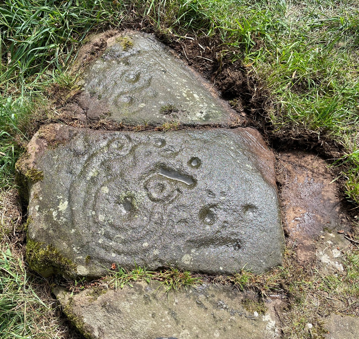
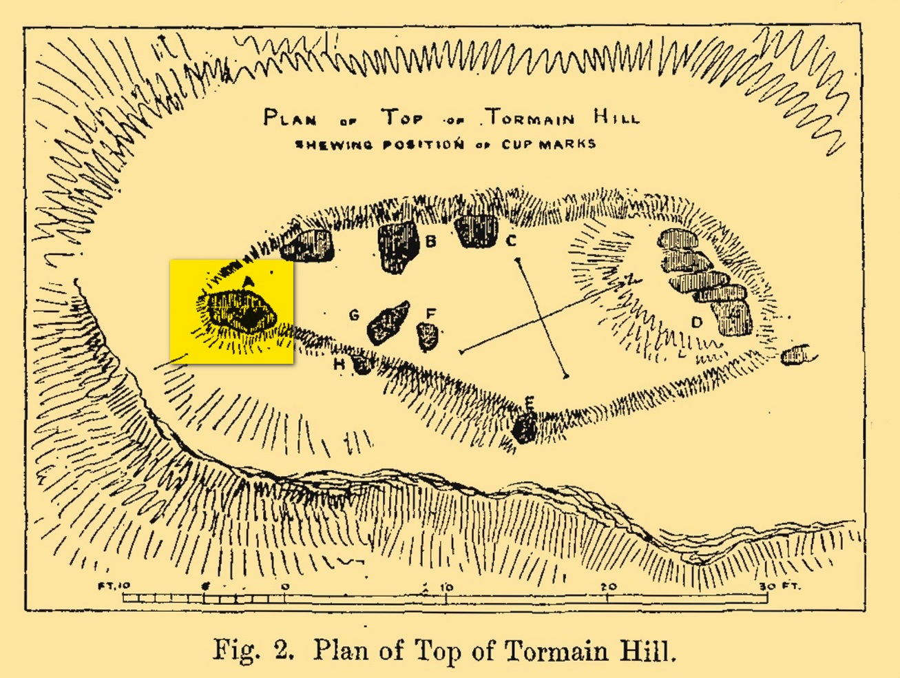
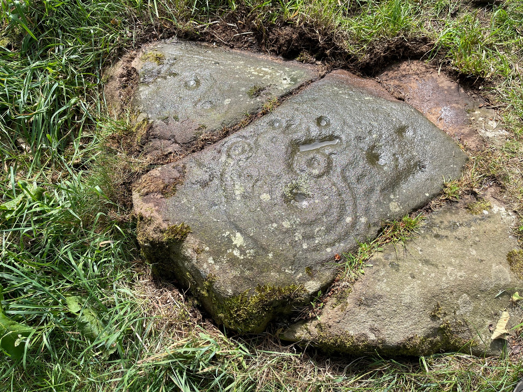
Tormain Hill, or the hill of stones (Harris 1996), has an interesting cluster of petroglyphs on its top, with this one in particular being the most impressive. It’s the southernmost stone in what’s been designated as a cluster of eight carvings—although we need to be slightly sceptical of one or two of them. Not this one though!
Regarded by Ron Morris (1981) as being “one of the best cup-and-ring designs in Scotland”, it was first mentioned by John Smith (1874) who visited the site with the local farmer James Melvin, who’d discovered the carving some years earlier. Initially he only noticed cup-markings, but when he visited the place with the pioneering rock art researcher Sir James Simpson, upon “removing the shallow soil or turf from the rock on the summit of Tormain Hill” this impressive multiple-ringed design came to light: “one cup (and) four concentric circles .”
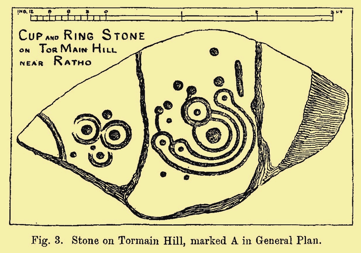
A few years later another rock art pioneer, J. Romilly Allen (1882) visited Tormain and found quite a bit more upon this hill. This particular carving, he told,
Allen’s 1882 sketchTormain ‘A’ site (Allen 1882)
“is much the finest and most remarkable in every way. It is the most southerly of the whole group, and is a piece of natural rock projecting from the side of the hill about 9 inches above the turf, and measures 4 feet 3 inches long by 2 feet 3 inches wide. Its upper surface is flat, of oval shape, and slopes slightly towards the hill. It is intersected by two parallel cracks of natural formation. The sculptures consist of twenty cups varying in diameter from three quarters of an inch to 2 inches in diameter. Seven of the cups are surrounded by a single ring, and one by four concentric circles. These latter are not complete, but form loops round terminal cups. Three of the cups with single rings are arranged in the form of a triangle. In addition to the cups and rings are two long grooves, one cutting off the corner of the stone, and the other parallel to one of the natural cracks.”
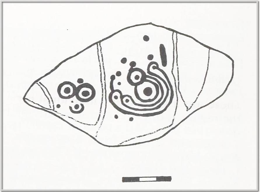
Beckensall’s 1986 version
More then forty years later the Royal Commission (1929) dudes visited the Tormain stones. It had become so overgrown by then that only two of the eight carved stones were visible: “but a search beneath the turf revealed the other sculpturings,” they told. It would seem that they chose a bit of a grey day when they came here as they told how the carving appeared “so much worn that the concentric rings are, in particular, difficult to follow.” So they did a rubbing of the stone—a common practice of rock art students over the last century or two. In doing so they were able to discern the following:
“The boulder is fractured in two places by natural agencies, but it shows traces of twenty cup-marks, varying from little more than half-an-inch to fully two inches in diameter, and there are two separate gutters. Seven at least of the cups are surrounded by single rings, and in two instances the rings are connected by shallow gutters to simple cup-marks. The largest cup-mark on the stone is encircled by one complete ring with three additional concentric arcs linking up four of the other rings. Another group consists of three cups, each surrounded by a ring, which are closely set in the form of a triangle, with three other smaller cup-marks in close proximity.”
Impressive stuff! In more recent times the site has gained the attention of fellow rock art explorers like Kaledon Naddair, Stan Beckensall and others—but we’re still none the wiser what it means!
Its position in the landscape was probably an important element. Pinus sylvestris (the ley-hunter’s favourite tree) grows spaciously, as it is wont, atop of the hill and, in bygone centuries, would have been much more prevalent before farming enveloped the land hereabouts. It was likely clear of trees on top of Tormain when the stone was carved, giving uninterrupted 360° views of the hills, high and low, as far as the eye can see. The legendary prehistoric Cairnpapple Hill stood out due west from the carving and other notable hilltops in the Pentlands would have had mythic relevance. Sadly, all oral tradition has long long faded and so whatever narratives that were told here have long ago been lost. It strikes me as a tribal gathering place: a moot hill perhaps. The bullaun stone adjacent to this fine carving would be a receptacle for paints, herbs, elixirs to be macerated and used by the people….
Check it out. Have a feel of the place. But spend a few hours here and listen to the wind…
Beckensall, Stan, Rock Carvings of Northern Britain, Shire: Princess Risborough 1986.
Beckensall, Stan, British Prehistoric Rock Art, Tempus: Stroud 1999.
Feachem, Richard, Guide to Prehistoric Scotland, Batsford 1977.
Hadingham Evan, Ancient Carvings in Britain: A Mystery, Garnstone: London 1974.
Harris, Stuart, The Place-Names of Edinburgh: Their Origins and History, Gordon Wright: Edinburgh 1996.
MacLean, Adam, The Standing Stones of the Lothians, Megalithic Research Publications: Edinburgh 1977.
Morris, Ronald W.B., “The Cup-and-Ring and Similar Early Sculptures of Scotland; Part 2 – The Rest of Scotland except Kintyre,” in Transactions of the Ancient Monuments Society, volume 16, 1969.
Morris, Ronald W.B., The Prehistoric Rock Art of Southern Scotland, BAR: Oxford 1981.
Royal Commission Ancient & Historical Monuments of Scotland, Inventory of Monuments and Constructions in the Counties of Midlothian and West Lothian, HMSO: Edinburgh 1929.
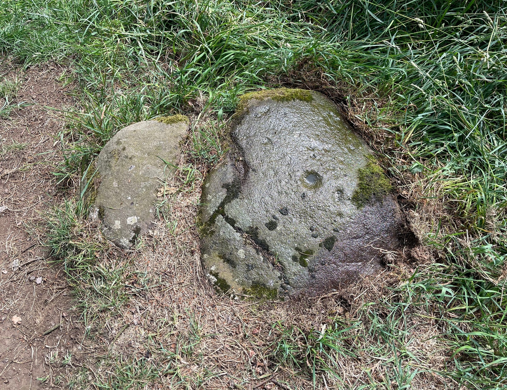
Found just a few strides away from the most impressive cup-and-ring stone at Tormain, is this quite un-impressive example and can easily be ignored. This simple cup-marked stone, first mentioned in Romilly Allen’s (1882) survey as “Stone B”,
“…lies 10 feet 3 inches to the north of stone A, and measures 4 feet by 2 feet 3 inches. It has a single cup cut on it.”
Tormain 2 “carving”Tormain 2 “carving”
Despite this being included in archaeological surveys as prehistoric, I’m unsure regarding the archaic authenticity of this single cup-mark and wonder whether it was just the result of idle dabblings by one of the quarrymen here in the 19th century. The lack of erosion leads me to suspect this. It has the appearance of cup-marks that have been carved by students at several different places in Britain (South Yorkshire, West Yorkshire, Perthshire, Renfrewshire, etc) over the last forty years. I’m quite happy to be wrong though! When the Royal Commission (1929) survey mentioned “a single cup on one boulder,” this may have been the one they were referring to.
Royal Commission Ancient & Historical Monuments of Scotland, Inventory of Monuments and Constructions in the Counties of Midlothian and West Lothian, HMSO: Edinburgh 1929.
Take the same directions as if you’re visiting the Tormain (1) carving (the best one of the bunch here), but about five yards before reaching it, to your immediate left, just at the edge of where the hill drops down slightly, you’ll see a small flat rock poking out of the ground that may have been cut and quarried at some time in the past. That’s the one!
Archaeology & History
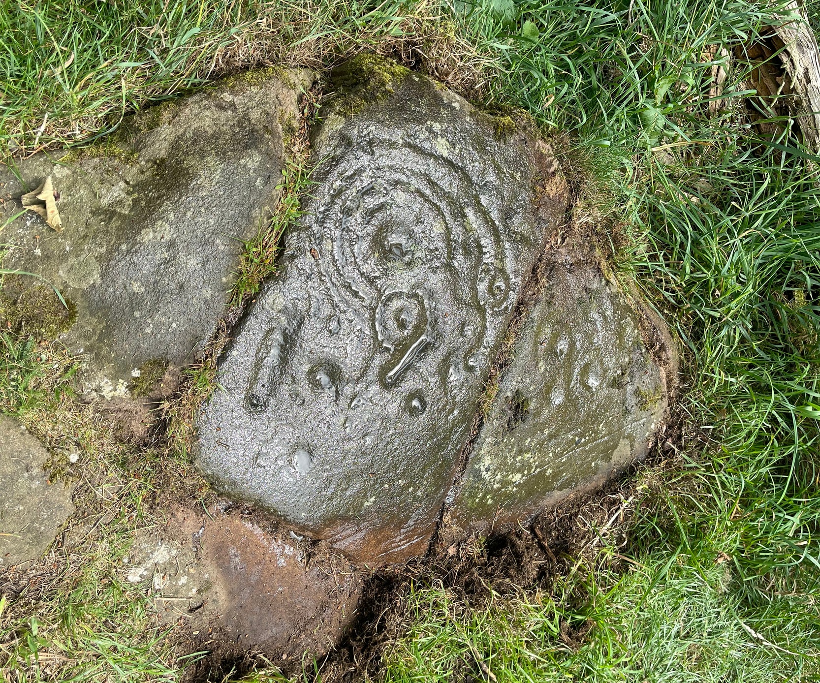
This small compact design looks like a typical cup-marked stone with the usual scatter of cups in no seeming order—until, that is, you walk around it and look at it from different angles, whereupon you’ll notice that a couple of distinct deep carved lines have been cut in a cross formation, with cup-marks at the ends of the crucifix. My view of this is that cup-marks were done first, probably in the standard Bronze Age period, and the ‘cross’ was cut into the stone at a much later date, probably during the early christian era. The depth of the lines which create the ‘cross’ is deep and thin at the bottom, suggesting a metal tool, which seems to have been cut into an natural crack. Visitors here will notice a small drill-hole near the edge of the stone which seems to have been done by local quarrymen, probably in the 19th century.
It was first described in Romilly Allen’s (1882) article on the Tormain stones. He called it ‘Stone E’ and told that it
Location of Tormain 5Cups, lines & cross form
“is situated about half-way between stones A and D, and is furthest to the east. It measures 1 foot 4 inches by 1 foot 9 inches, and projects 1 foot above the turf. Its upper surface is flat, and on it are carved eight cups varying in diameter from 1 to 2½ inches. There are two connecting grooves between three of the cups, forming a rude cross. Another cup has a channel leading over the edge of the stone.”
In November 1927, the Royal Commission dudes visited the carving (and its companions), but they had to roll back the turf to see it clearly. On the stone they saw that “at least nine or ten cup-markings, in some cases with connecting gutters, are still more or less clearly outlined.”
Carving highlighted (Morris ’82)Ron Morris’s old photo
When Ron Morris (1981) visited here, he highlighted the carving in chalk to get a decent impression of the design, as the attached photo here shows. Many traditional cultures ritually paint their carvings at set times of the year, in traditions that go back many centuries—perhaps even millenia. In all probability the same thing was done at some of the British petroglyphs, although there are no remaining traditions. Anyhow, Morris described it succinctly as:
“½m square, ¼m high…on which are: eight cups up to 7cm (3 in) diameter and 4cm (1½ in) deep and some grooves, to of which connect some of the cups to form a well-defined Cross.”
The stone was looked at by the great rock art explorer Kaledon Naddair of Edinburgh, but sadly I’m unable to locate his report and the fine illustrations that always tended to accompany them. If you’re reading this sir, give us your valuable input!
Beckensall, Stan, Rock Carvings of Northern Britain, Shire: Princess Risborough 1986.
Beckensall, Stan, British Prehistoric Rock Art, Tempus: Stroud 1999.
Feachem, Richard, Guide to Prehistoric Scotland, Batsford 1977.
Hadingham Evan, Ancient Carvings in Britain: A Mystery, Garnstone: London 1974.
Morris, Ronald W.B., “The Cup-and-Ring and Similar Early Sculptures of Scotland; Part 2 – The Rest of Scotland except Kintyre,” in Transactions of the Ancient Monuments Society, volume 16, 1969.
Morris, Ronald W.B., The Prehistoric Rock Art of Southern Scotland, BAR: Oxford 1981.
Royal Commission Ancient & Historical Monuments of Scotland, Inventory of Monuments and Constructions in the Counties of Midlothian and West Lothian, HMSO: Edinburgh 1929.
Acknowledgements: Huge thanks to Jan Carrington for use of her photos. 🙂
Cup-Marked Stone (missing): OS Grid Reference – ND 04321 56794
Archaeology & History
When Alastair MacLaren (1955) first excavated an Iron Age hut circle just above the northern edge of Loch Shurrery, he found, “from the tumble of the wall came a cup marked stone.” It emerged from southwestern side of this habitation site, on a small portable-sized stone, and consisted of just a single distinct cup-mark. When the site came to be re-examined many years later, it had gone. MacLaren was of the opinion that the stone had merely “served as core material and was of no other significance to the builders of the hut circle than just a handy bit of rubble to fill the space between the inner and outer faces.” This may have been the case; although it may have originally been carried from one of the many chambered cairns in the region.
An interesting new cup-marked stone found by Paul Blades is this smooth rounded (female) stone that may originally have had some relationship with the tall standing stone of Careg Bica 160 yards to the south. Around ten cup-marks are etched onto its surface, in a seemingly random arrangement (as usual!). Although it seems to be an isolated carving, it’s likely that others will exist in the area.
Carving & outlying monolithCareg Bica petroglyph
The direction and proximity of the standing stone may have had some relationship with the carving. In traditional northern hemisphere societies, the cardinal direction North is generally associated with darkness and death, primarily due to the fact that this is the area in the heavens where neither sun or moon ever appear; whilst South relates to life and positive natural associations due to it being the high point of the sun during the day. This animistic attribute existed till recently in the water-lore of northern England and Scotland where “south-running streams bore a high repute.” Whilst such mythic attributes are well established, any cardinal relationship here is purely speculative.
Acknowledgements: Huge thanks to Paul Blades for use of his photos in this site profile – and of course for finding the stone!
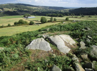
Follow the directions to reach the Ancestors’ Stone and the Sunrise Stone; and there, roughly halfway between them, right by the edge of the old collapsed walling, you’ll see this rise of a stone with a large ‘bowl’ on top. That’s it!
Archaeology & History
Mixing Stone, looking E
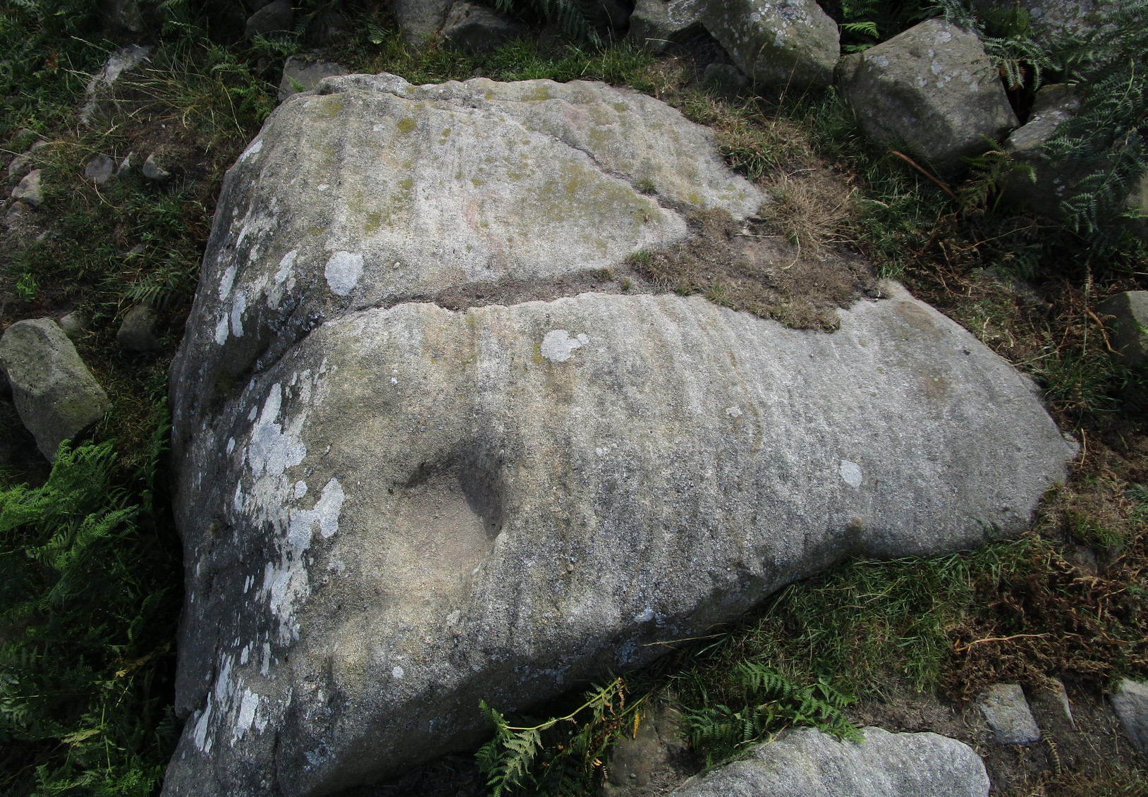
Laid upon the same geological ridge as our Ancestors’ and Sunrise carvings, there are one, possibly two faint cup-marks visible on the low flat surface near the edge of this rock, barely visible unless the light’s right. But the important element here, perhaps regardless of the cup-marks, is the ‘bowl’ or rock basin on top of the stone. Internally, it’s smoothed equally on all sides and, due to being in-between the two impressive petroglyphs, may well have had a practical function to it. Bear with me on this one…
The Mixing Stone’s bowl
Stone ‘bowls’ or cavities—natural and otherwise—have been made use of in many cultures for simple functional purposes, such as grinding flour, herbal mixes, etc. We find such traditions in some of the bullauns of Ireland and Scotland; whereas in similar stone bowls known as cat troughs in nearby Haworth, milk was poured to appease the spirits of the land (this tradition was still being maintained in 2001!). Folklore and traditions of such rock basins spread far and wide beyond the UK: one of the German terms for rock basins is Opferkessel, meaning ‘sacrificial basin’ and suggests ritualistic usage by early societies. Elsewhere on Earth there are numerous accounts of the ritual use of petroglyphs in which indigenous peoples tell of their use of plant- or rock-based paints (in many cases red ochre) to decorate the carvings. And it’s this element that I’m interested in here.
Water-painted cupmarks
The Sunrise and Ancestors’ Stones 10-15 yards either side of this Mixing Stone are ideal candidates for such petroglyphic paintings using early ochre and other stone or plant-based agents. Such activities would always have been ritualised, either in honour of ancestors, genius loci, calendrical rites, or whatever the pertinent ingredient was at that place and time. I’m suggesting simply that the rock basin on the Mixing Stone was used for just such purposes. This is no spurious suggestion, but at the same time it’s important to recognise that my thoughts here represent merely an idea, nothing more—not a fact. Whilst we know full well that these carvings were imbued fundamentally with animistic properties—a simple ‘fact’—this functional idea is just that—an idea. Students and petroglyph-nuts need to understand this. And the faded cup-marks at its edge are perhaps merely incidental…. though I don’t buy that misself!