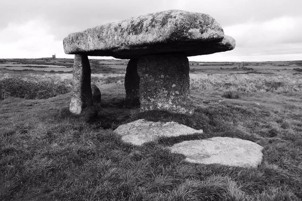
William Borlase (1769), in his revised classic on the megaliths & antiquities of Cornwall, wrote:
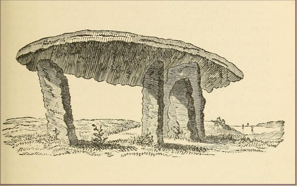
“Since we are now considering these Stone-monuments, there is a very singular Monument in the Parish of Madern (Cornwall) which in this place, will naturally offer itself to our enquiry. In the Tenement of Lanyon stand three Stones-erect on a triangular Plan. The shape, size, distance and bearing, will best be discerned from the plan and elevation of them…
“The length of the area described by the supporters of Lanyon Quoit is seven feet; but it does not ſtand East and West, as at Molfra, but North and South… There is no Kist-vaen, that is, no area marked out by Side Stones, under this Quoit, which is more than 47 feet in girt, nineteen feet long; its thickness in the middle, on the Eastern edge, is sixteen inches, at each end not so much, but at the Western edge this Quoit is two feet thick. The two chief supporters…do not stand at right angles with the front line, as in other Cromlehs, but obliquely, being forced from their original position, as I imagine, by the weight of this Quoit, which is also so high that a man can fit on horseback under it. Under this Quoit I caused to be sunk a pit of four feet and half deep, and found it all black earth that had been moved, and should have sunk still deeper, but that the Gentleman in whose ground it is, told me, that a few years before, the whole cavity had been opened (on account of some dream) to the full depth of six feet, and then the faster appeared, and they dug no deeper; that the cavity was in the shape of a grave, and had been rifled more than once, but that nothing was found more than ordinary. This Cromleh stands on a low bank of earth, not two feet higher than the adjacent soil, about 20 feet wide, and 70 long, running North and South: at the South end has many rough Stones, some pitched on end, in no order; yet not the natural furniture of the surface, but designedly put there; though, by the remains, it is difficult to say what their original poſition was. Wet N. W. there is a high stone about 80 yards distance. By the black earth thrown up in digging here, nothing is to be absolutely concluded, there having happened so many disturbances. By the pit being in the shape of a grave, and six feet deep, it is not improbable that a human body was interred here, and by the length of the bank, and the many disorderly stones at the South end, this should seem to have been a burial place for more than one person.”
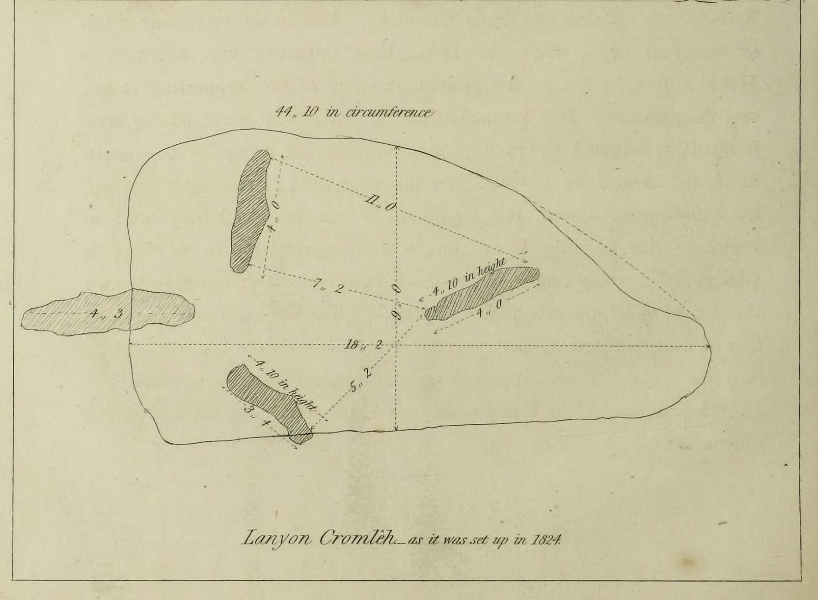
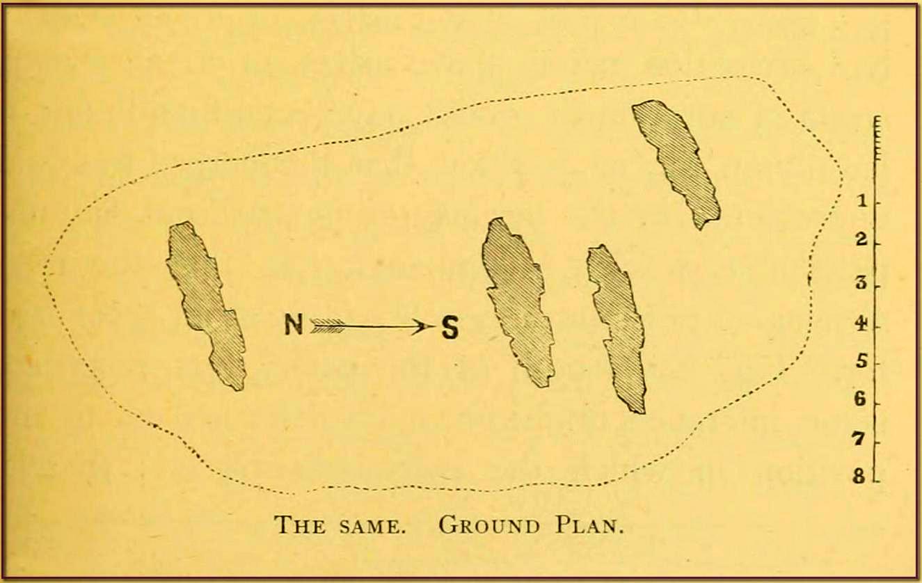
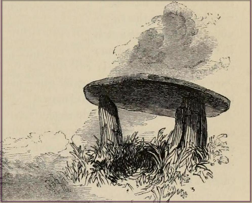
William Borlase 1769 ground-planWilliam Borlase 1769 sketch
Antiquarian Notes
William Cotton, in 1827, told that:
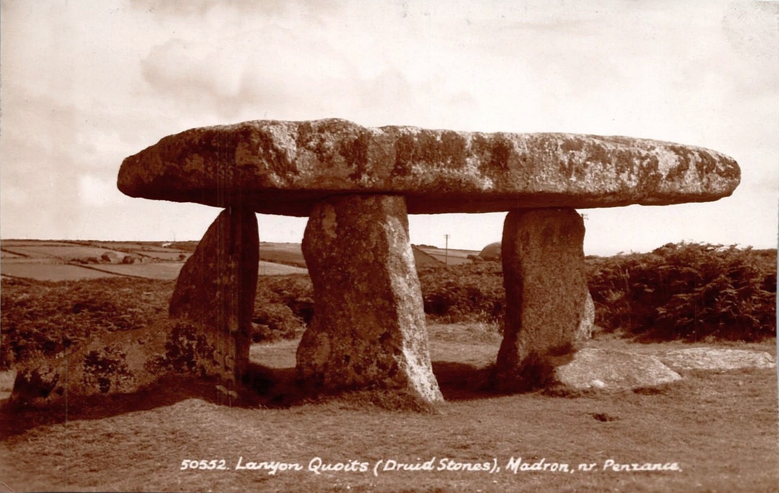
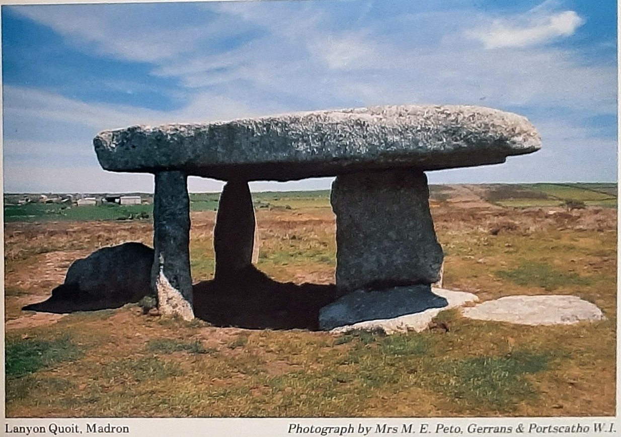
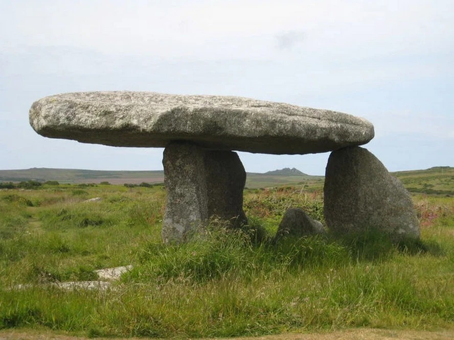
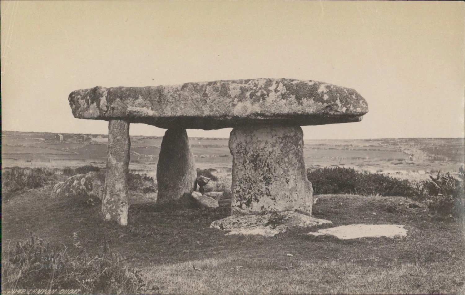
“About a mile and a half north of the church, in the parish of Maddern, and close to the road side, is Lanyon Cromleh, so called from the name of the estate on which it stands. The covering stone, which is nearly flat, and of a triangular figure, measures 44 feet 10 inches in circumference, 18 feet 2 inches in its greatest length, and 9 feet in width, and weighs 15 tons. This Quoit, as it is usually called, was originally supported on four upright stones, describing an open area 7 feet in length, north and south, but not forming an enclosed Kistvaen, like Molfra and Chun Cromlehs. During a very violent storm in the year 1815, when the Delhi East Indiaman was wrecked in Mount’s Bay, it fell to the ground, and one of the supporting stones was then broken. It is probable that the earth beneath it, having been frequently loosened by excavations, was washed away by the heavy rains, and caused its downfal. In the year 1824 it was again set up, by subscription among the inhabitants, with the machinery used in replacing the Logging Rock, under the superintendence of Captain Giddy, R.N., whose zealous exertions overcame every difficulty, and merit the thanks of all topographical antiquaries. The Cromleh now stands as firm as ever: in putting it up, a piece was broken off the top stone, at A, (see the plan). It is supported on three upright stones, each 4 feet 10 inches in height, the tops having been made level, and their positions a little altered.
“This view represents Lanyon Cromleh as it now stands, and differs from all the prints I have seen of it, — which have been uniformly copied from Dr. Borlase’s book, and do not, by any means, give a correct representation. The doctor says, in his time a man on horseback could ride under the incumbent stone — now, its height from the ground is only 4 feet 10 inches. The figures 1824, to mark the year when it was re-erected, have been rudely inscribed on one of the supporting stones.
“Dr. Borlase caused an excavation to be made under this Cromleh, as well as under the last mentioned, but without discovering any human bones ; he was led, however, to conclude, by the appearance of the earth, that a body had been interred there.”
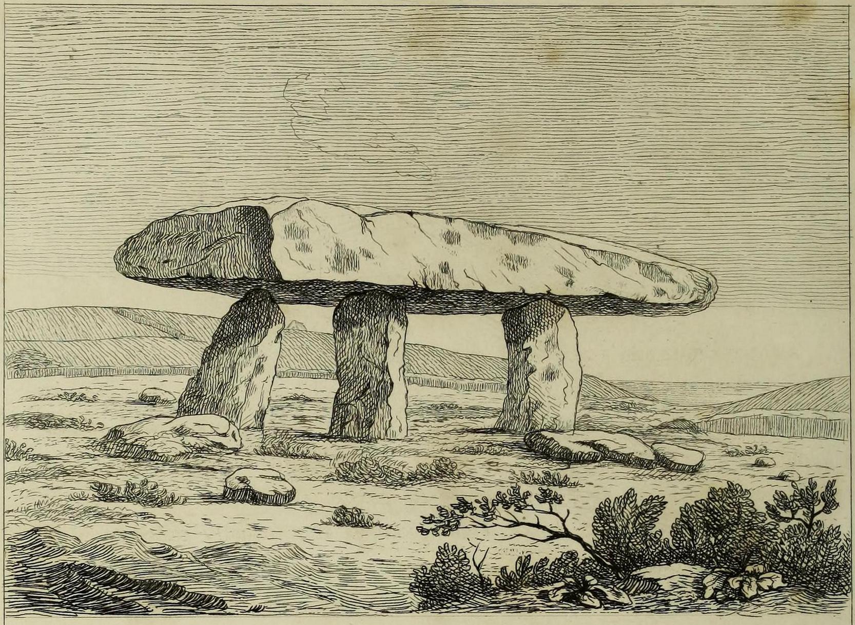
Cotton’s 1827 sketch
Antiquarian Notes
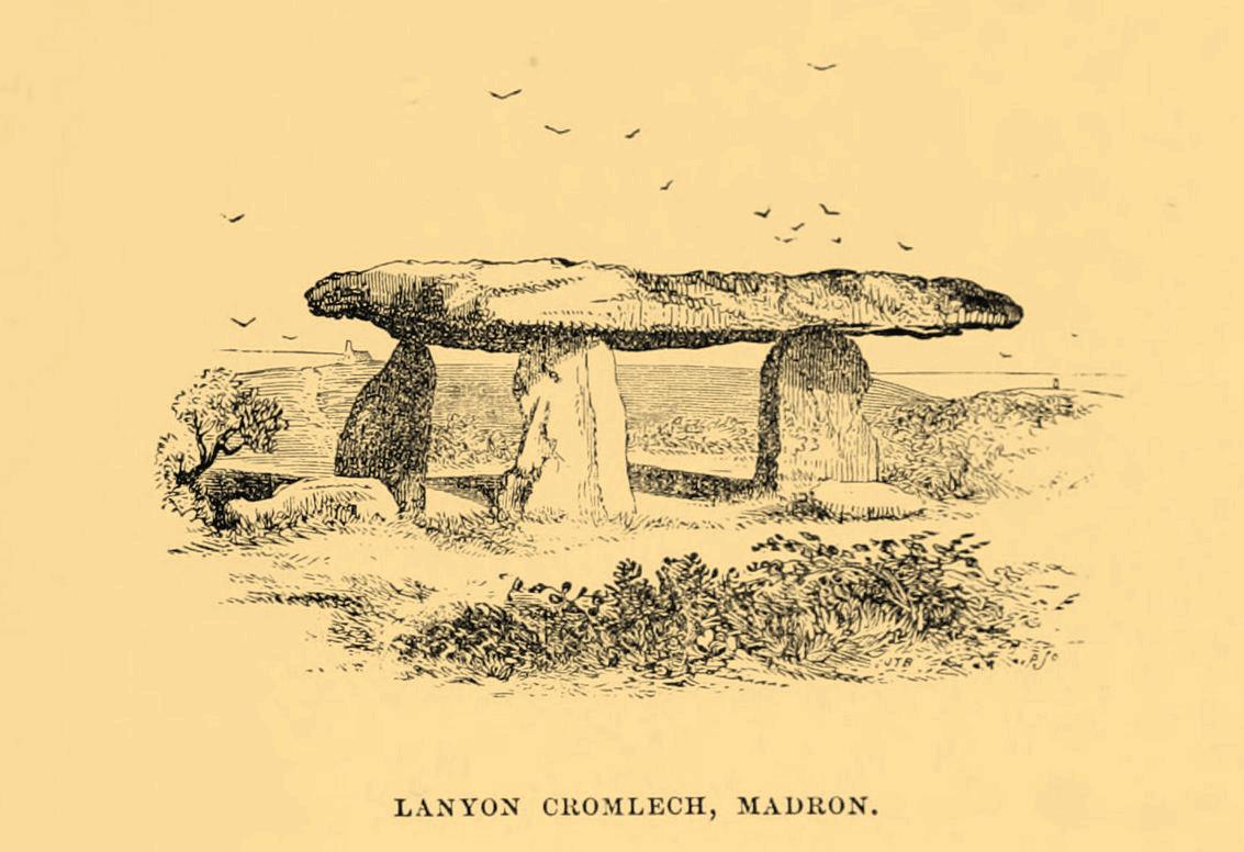
James Orchard Halliwell wrote, in 1861:
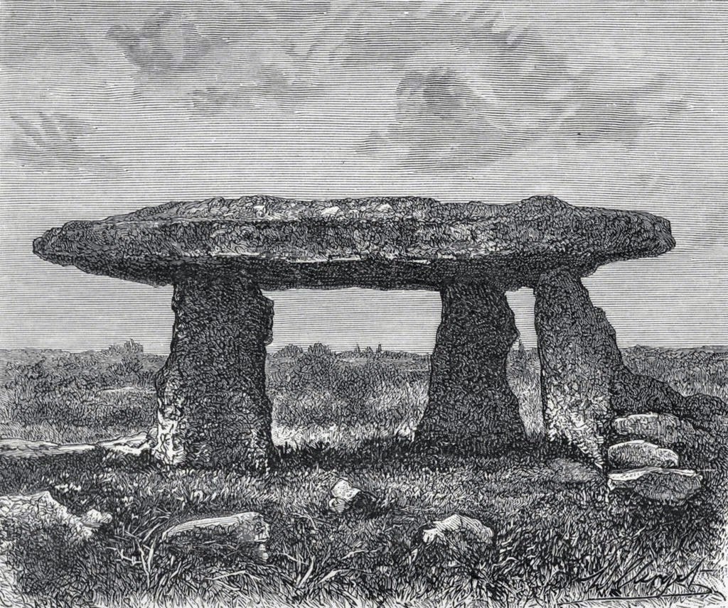
“At a distance of some five miles from Penzance, on the road from Madron to Morvah, near the road, on the right-hand side, is the Lanyon Quoit or Cromlech, a fine specimen, and perfect in all essential particulars. The best way of reaching it, if walking, is to take the path to the left in the fields after passing the Madron Union, and keep as nearly in a straight line as possible until the cromlech appears. It is situated in a conspicuous situation in the midst of a wild moor, and is interesting in its Titanic grandeur and vast antiquity. The top covering consists of an enormous flab of granite, supported by three upright unhewn blocks of stone, but near there are three fallen stones, one of which at least was certainly at one time one of the supporters. The dimensions of the cap-stone are thus given by Borlase: —
“This quoit is more than forty-seven feet in girt, and nineteen feet long ; its thickness in the middle on the eastern edge is sixteen inches, at each end not so much, but at the western edge it is two feet thick.”
This cromlech is sometimes called by the country people the Giant’s Quoit, and occasionally the Giant’s Table. My measurement made the covering-stone forty-fix feet in circumference, with a thickness varying from ten to eighteen inches. It is not improbable that the stone has been chipped off at one or two of the corners since the time of Borlase. Between the cromlech and the road are the remains of a stone and earth circular barrow about eighteen feet in diameter. There is an odd tradition that the first battle fought in England was decided in the locality of Lanyon Quoit.”
Blight, J.T., A Week at the Land’s End, Longmans Green: London 1861.
Borlase, William, Antiquities, Historical and Monumental, of the County of Cornwall, Bowyer & Nichols: London 1769.
Borlase, William Copeland, Nænia Cornubiæ, Longmans Green Reader: Truro 1872.
Colquhoun, Ithell, The Living Stones, Cornwall, Peter Owen: London 1957.
Cooke, Ian, Antiquities of West Cornwall – Guide 1, Cornwall Litho: Reduth 2002.
Halliwell, J.O., Rambles in Western Cornwall in the Footsteps of Giants, John Russel Smith: London 1861.
Jewitt, Llewellynn, Grave Mounds and their Contents, Groombridge: London 1870.
Redding, Cyrus, An Illustrated Itinerary of the County of Cornwall, How & Parsons: London 1842.
Russell, Vivien, West Penwith Survey, Cornwall Archaeological Society: Truro 1971.
Straffon, Cheryl, Megalithic Mysteries of Cornwall, Meyn Mamvro: Penzance 2004.
Acknowledgements: Huge thanks for use of the Ordnance Survey map in this site profile, reproduced with the kind permission of the National Library of Scotland.
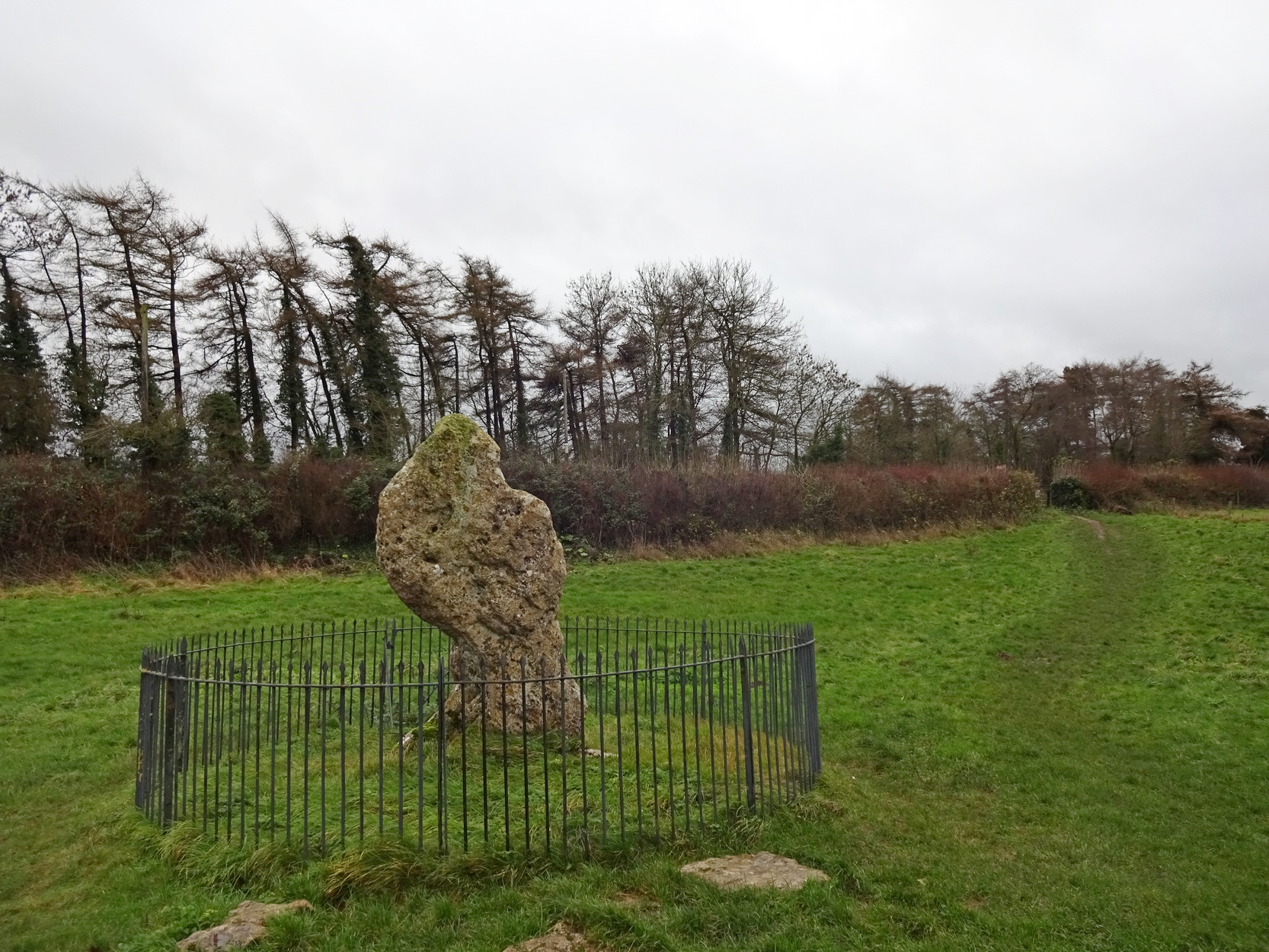
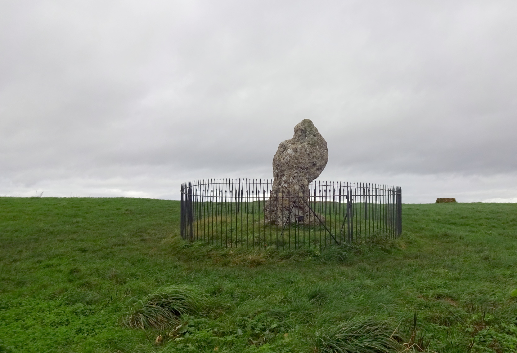
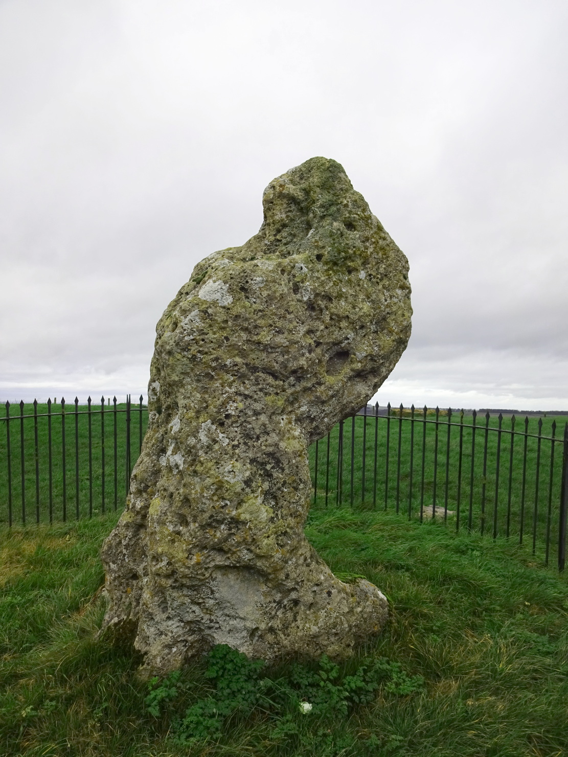
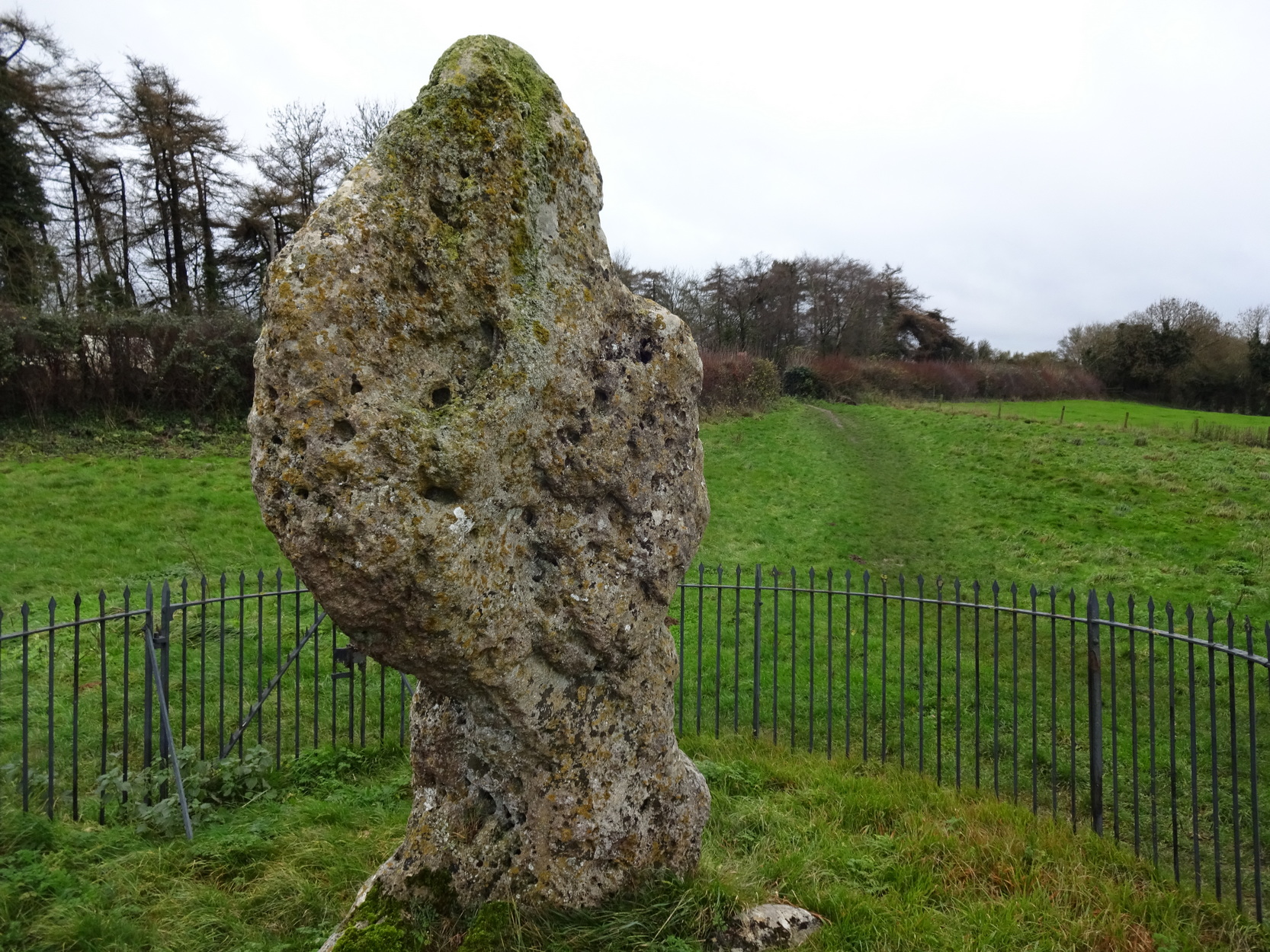
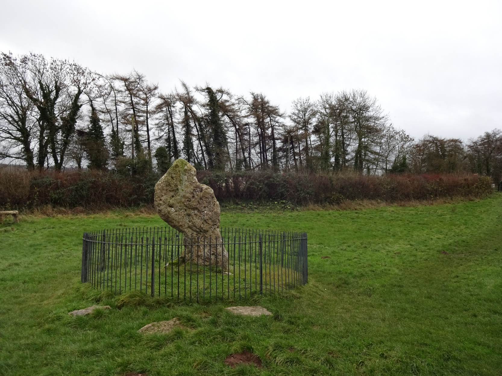
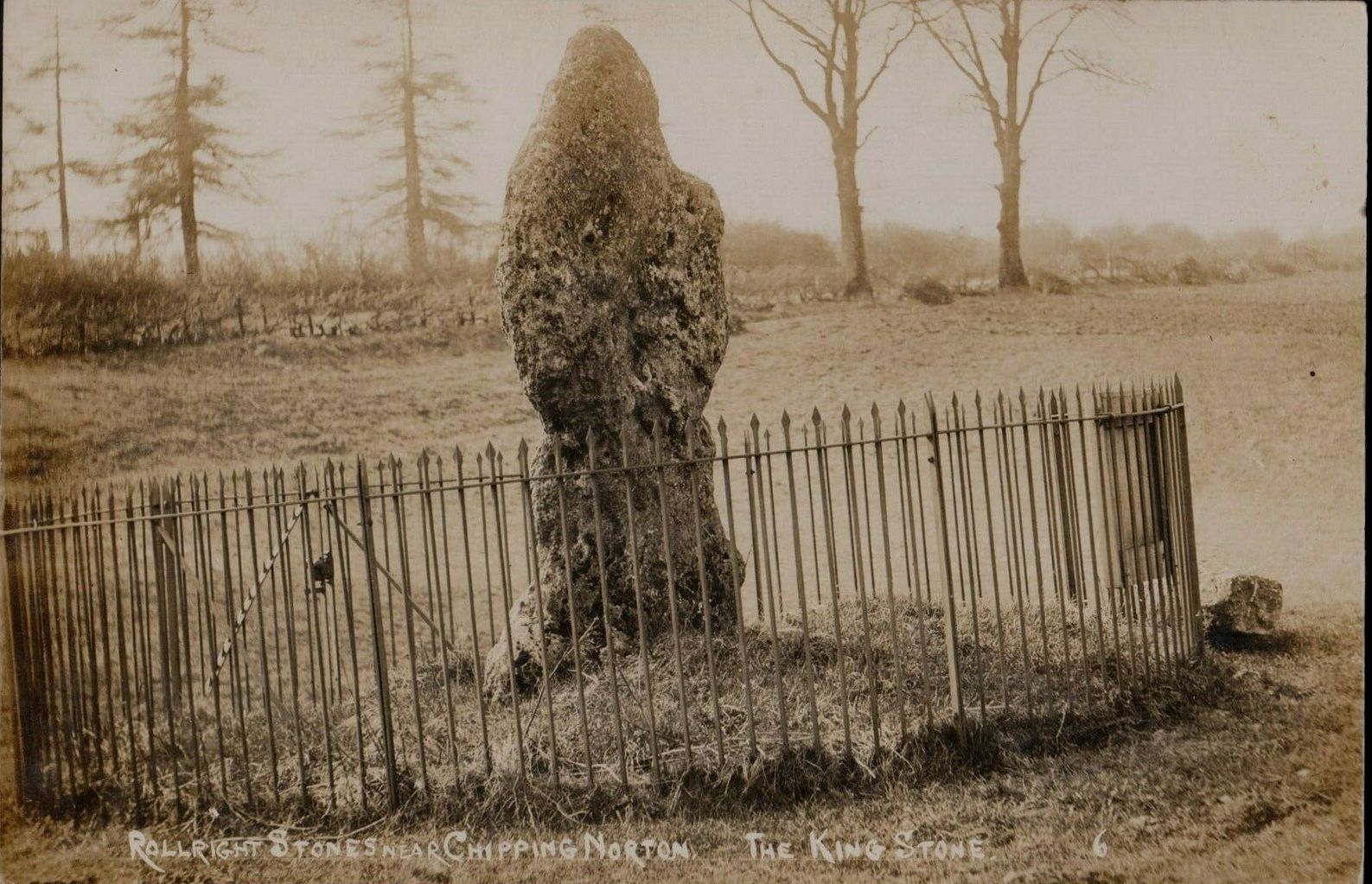
The King Stone of Rollright (photo by Sir Wilson III)
If you’ve reached the impressive Rollright Stone circle, simply cross the road, go through the gate and into the field, then up the gentle slope to your right. Y’ can’t miss it! If though, by any chance, you can’t find the Rollright Stones, get to Chipping Norton and ask a local!
Archaeology & History
An integral part of the Rollright Stones complex, this gnarled almost moth-eaten-looking standing stone, whose edges were cut away for medicinal properties in earlier centuries, still awakes each morning beside the small rise in the field, long thought to have been the remains of an ancient tomb — much to the archaeologist’s opinionated disdain in bygone years. Yet they had to swallow their pride…
This is an eight-foot-tall standing stone made from the same local oolitic limestone as the King’s Men and overlooks the village of Long Compton on the northern side of the ridge. It actually stands besides an artificial mound which has been identified as a Bronze Age cairn—known in times past as the ‘Archdruid’s Barrow’— and suggested by Lambrick to date from around 1800 BCE. More recently however, the world’s leading authority on stone circles, Professor Aubrey Burl, has given the King Stone a more probable construction date of 3000 BCE. The date is consistent with other Neolithic finds in the adjacent fields. This old standing stone has suffered much down the centuries, with bits of it being chipped away to such an extent that it has been reduced to the novel shape we see today.
Looking up at the King (photo by Sir Wilson III)
The King in dance
A little-known but important piece of megalithic history took place here in the 1970s and ’80s. It centred around an idea to investigation so-called “mysterious events” that are commonly reported at standing stones—and the King Stone has its own CV when it comes to such things. Curious stories have been described by people from all walks of life. Down the years, a number of people have told me of feeling some strange and powerful ‘energy’ at these places and stories of such things have filled many volumes, along with being the subject of many a folktale. So one evening in November, 1977, the then editor of The Ley Hunter, Paul Devereux, convened a meeting where twenty people from differing backgrounds gathered. At this first meeting were people from a variety of professional backgrounds: archaeologists, dowsers, chemists, biochemists, biologists, electronic engineers, geochemists, geophysicists, zoologists—and ley hunters of course. It was time, they thought, to address this issue of anomalous energies at stone circles and other ritual sites.
After some discussion about what they should call their investigations, “the long association of the dragon with some kind of earth force made it a fitting symbol.” And so, the Dragon Project (DP) was born…
On the misty morning of Saturday, 24 October, 1978, research scientist Don Robins—in the company of his dog and young son—drove the hundred miles from London to the Rollright Stones armed with a simple ultrasound detector. He didn’t know what he would find there, and his scientific training told him there shouldn’t really be anything untoward.
King Stone, looking W (photo by Sir Wilson III)
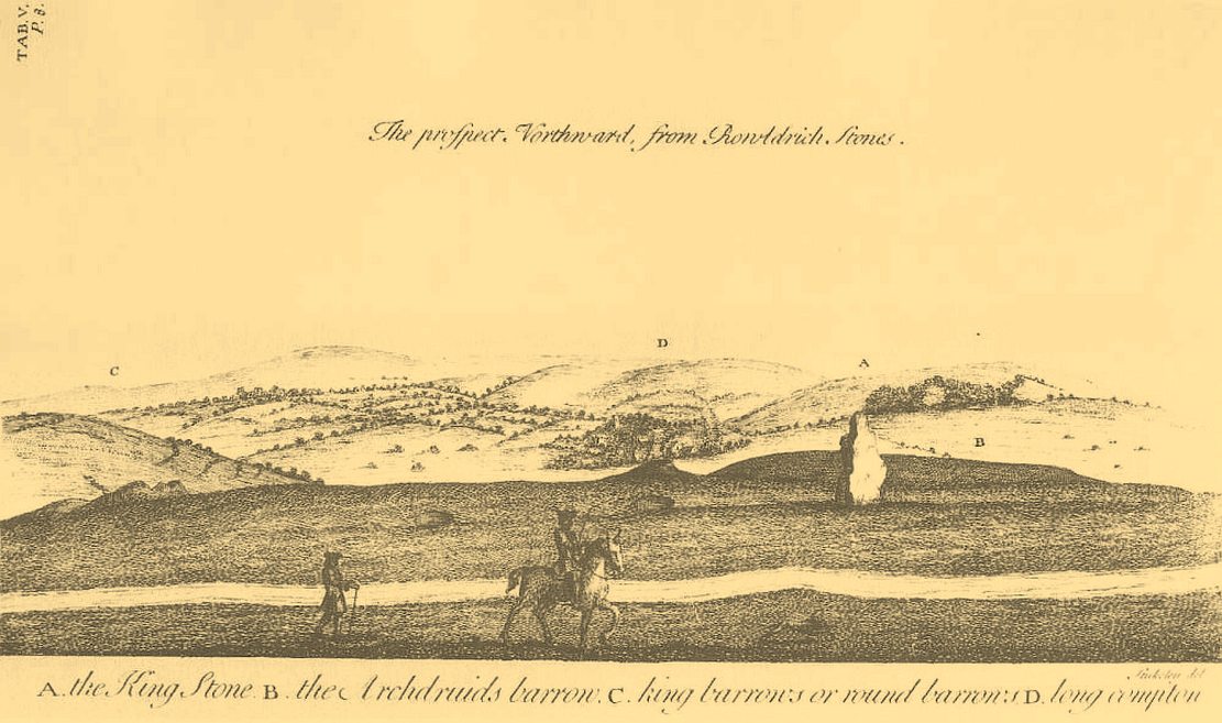
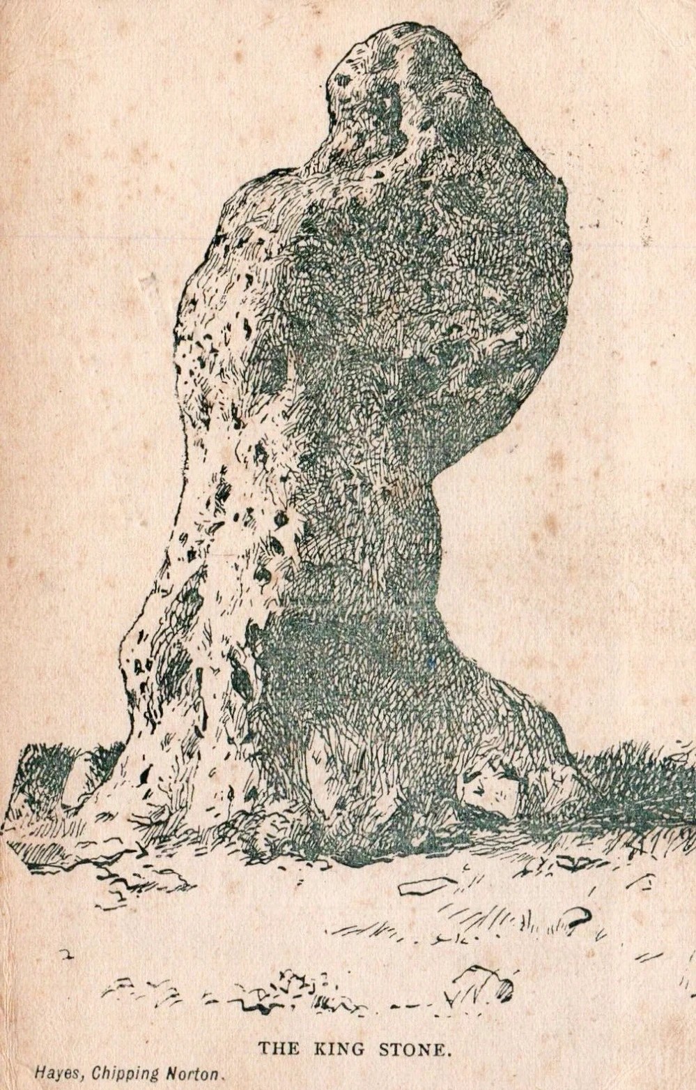
Stukeley’s 1743 sketch showing the King Stone
Arriving around dawn, Robins took several background readings along some of the lanes a mile or so away and found the usual expected background levels (on a scale of 1-10, the background flickers between 0 and 1). When he eventually walked into the Rollright stone circle with his ultrasound monitor, no undue perturbations were found. He spent thirty minutes here, but at no time did he record anything other than background readings. So he crossed the road and tried the same at the King Stone—where a big surprise awaited him.
Switching on the detector he found an anomalously high reading, beating every minute or so, not unlike a heartbeat, more than five times above the background ultrasound!
“This was really peculiar,” he wrote, “in that the pattern was spread over about a minute and then commenced again after about 10 seconds, endlessly repeated.” Robins spent some time here and found that the strange ‘pulse’ wasn’t solely confined to the King Stone, but spread some distance around the old standing stone and onto the road itself.
Investigation of potential radiation anomalies was another avenue of enquiry explored by the Dragon Project, and although thousands of hours of monitoring were done at the three focal sites, there were few anomalies to write home about. Two however, were recorded in March and August, 1981, when radiation levels were twice the normal background rate for short periods of just a few minutes each. More puzzling was the finding—which can still be verified today—of radiation levels three and four times above background on the road between the circle and the King Stone.
Next on the list was an attempt to monitor the Rollright stones with infrared devices. This proved to be a potential goldmine, as there was the chance of photographic imagery. So early one morning in April, 1979, Paul Devereux readied himself at the King Stone. He took a number of photos at five minute intervals either side of sunrise. This time of day was chosen because of the repeated anomalous ultrasound emissions from the King and it was thought that this, if any, would be the best time to capture something on film.
“When the first roll of black-and-white IR film was professionally developed,” he wrote, “I was astonished to see a curious ‘glow’ effect around the King stone on the frame taken at sunrise.” His first account of it appeared in The Ley Hunter, where he described how “a hazy glow can be seen clinging to the sides and upper parts of the megalith. This glow becomes much stronger at the top of the stone where it looks like a cap of light.” Although the sun had risen, it was off to the left of picture and apparently no satisfactory explanation can be given to the effect on the plate. Research physicist Simon Hasler—who worked for Kodak—closely studied the negatives of this image and found the evidence for a simple explanation “weak.” A possible explanation of the mysterious glow was propounded by Don Robins, who suggested that an emission of microwaves from the stone may have been responsible, and although this sounds promising it has yet to be proven.
Folklore
(photo by Sir Wilson III)
Amidst the mass of modern lore, dowsed energy lines exceed here — although to be honest, most of them are little more than bullshit. Old school alignments in the form of leys that can be walked along are more credible, and one or two have been noted here. Dowser Laurence Main found a ley running between Broughton Church, “the old White Cross, the Victorian Cross and the old Bread Cross in Banbury. In the other direction the line led straight to the King Stone.” Although this line accurately links up these sites, other ‘ley points’ are utterly necessary between Broughton Church and the King Stone to give the alignment any real credibility. In a concise survey of the megalithic remains of this region made by Tom Wilson and myself, no other ley-points were found along the line.
In more traditional animist-based folklore, the creation myth here is well known. The famous, oft-repeated tale recites how a King and his men were marching across the land intent on conquering it when he came across an old hag, or witch near Rollright who offered the regal figure a magickal challenge. Some accounts name the witch as Mother Shipton—not the famous Yorkshire seer of the same name, but her less powerful (obviously!) southern counterpart. The old witch said to the King:
“Seven long strides thou shalt take, and
If Long Compton thou can’st see,
King of England thou shalt be.”
His majesty took this as a simple task and, with contempt, said to the old witch:
“Stick, stock, stone,
As King of England I shall be known.”
From where he was standing (which is never told, but presumed by most as the stone circle) the King then took seven long strides in the direction of Long Compton. As he was taking his seventh step the witch made the ground in front of him rise up, hence blocking his view of the village in the valley below. The old hag then said:
“As Long Compton thou canst not see,
King of England thou shalt not be.
Rise up, stick, and stand still, stone,
For King of England thou shalt be none;
Thou and thy men hoar stones shall be
And I myself an eldern tree.”
Thereupon, the King’s men who were waiting behind their master, the five knights in the field who were said to be conspiring against his majesty, and the King himself, were all turned into stone where they stood. The elder tree that the old witch turned herself into, was said to have grown along the old boundary close to the roadside, but this can no longer be verified. The folklorist Arthur Evans described several spots where the famed elder tree was said to have grown: one in the field close to the Whispering Knights, and another in the same field as the King Stone, close by another large stone that has long since gone.
When William Stukeley visited the area in the 18th century and heard about the legendary origin of these great monoliths, he told how “the country people for some miles round are very fond of, and take it very ill if anyone doubts it,” telling later, “The people who live at Chipping Norton and all the country round our first described temple of Rowldrich affirm most constantly, and as surely believe it, that the stones composing this work are a king, his nobles, and Commons turned into stones.
Another piece of animistic lore tells how the King Stone and the Whispering Knights venture, at midnight, less than half a mile south to drink from a spring in the small woodland at Little Rollright Spinney—although it is difficult to ascertain precisely which of the two springs the stones are supposed to visit. In some accounts, the stones reputedly drink from the well every night, but others tell that they only go there at certain times of the year, or on saint’s days. When Arthur Evans wrote of these tales he described there being a “gap in the bushes… through which they go down to the water,” but the terrain has altered since his day.
A variation of the same tale was told by T.H. Ravenhill, who wrote:
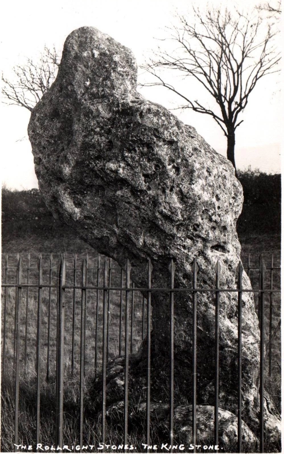
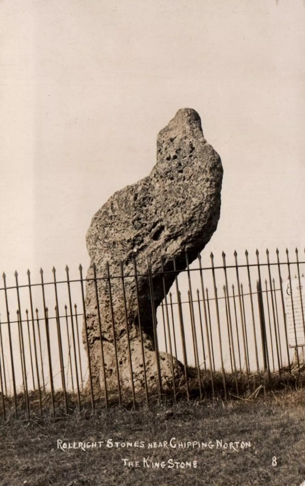
The old King c.1945
King Stone, c.1920
“The Lord of the Manor of Little Rollright desired to possess the King’s Stone in order to bridge Little Rollright brook. So he dug it up and tried to cart it away, but found that he had not enough horses. He hitched on more, and yet more, and still he found that he could not move the stone. Finally he succeeded and hauled the stone away to the Manor House. The same night he was alarmed by strange sounds about the house, which he attributed to the presence of the King’s Stone, and decided, therefore, to replace it on its mound. No sooner had he harnessed the first horse to the cart than it galloped away up hill with ease, taking with it the stone, which leapt to position on reaching its resting place.”
Evans also wrote about an eighty-year-old local woman who told that her mother visited the King Stone on Midsummer’s Eve, along with many other locals, when the elder was in full bloom and they would stand in a full circle around the tall monolith. Ritual of a sort was performed then the elder tree was cut and, as it bled, “the King moved his head.” This annual rite was said to partially disempower the witch of her magickal hold over the King when her blood trickled from the tree. Some locals believed that if but a pin-prick of the witch’s blood was drawn, she would lose her power for all eternity.
Beneath both the Rollright stone circle and the King Stone, legend reputes there to be such a cavern where the little people live. In some accounts they are said to dance around the old King.
Arthur Evans told how one local man, Will Hughes, actually saw the faerie dancing round the King.
“They were little folk like girls to look at,” he said.
Old postcard, c.1910
Sketch from 1904
Will’s widow, Betsy Hughes, told Evans that “when she was a girl and used to work in the hedgerows, she remembered a hole in the bank by the King Stone, from which it is said the fairies came out to dance at night. Many a time she and her playmates had placed a flat stone over the hole of an evening to keep the fairies in, but they always found it turned over next morning.” This curious entrance was a neolithic burial mound. Mark Turner described how the little people were “supposed to come out and dance around the stones by moonlight.”
As we have already seen, people used to take chippings off some of the old stones here—primarily the King—supposedly for luck, protection and good fortune. Local people used to blame Welsh workers more than anyone, but they wouldn’t be the only ones! Although those who took such chippings believed the pieces brought them luck, more often than not it was the opposite that happened. One local woman told Evans about her son who went to India as a soldier in the 19th century with a piece of the King Stone in his possession, but it did him no good whatsoever. He died of typhus! The Oxford archaeologist George Lambrick (1988) highlights in his book on the Rollright stones the extent of damage that has been done to the King Stone since 1607.
References:
Anonymous, The Rollright Stones: Theories and Legends, privately printed, n.d.
Bennett, Paul & Wilson, Tom, The Old Stones of Rollright and District, Cockley: London 1999.
Bloxham, Christine, Folklore of Oxfordshire, Tempus 2005.
Cowper, B.H., ‘Oxfordshire Legend in Stone,’ Notes & Queries (1st series), 7, January 15, 1853.
Devereux, Paul, ‘Is This the Image of the Earth Force?’ in The Ley Hunter 87, 1979.
Devereux, Paul, ‘Operation Merlin,’ in The Ley Hunter 88, 1980.
Devereux, Paul, ‘Operation Merlin 2,’ in The Ley Hunter 89, 1980.
Devereux, Paul, ‘The Third Merlin,’ in The Ley Hunter 92, 1981.
Devereux, Paul, Places of Power, Blandford: London 1990.
Devereux, Paul, The Sacred Place, Cassell: London 2000.
Evans, Arthur J., ‘The Rollright Stones,’ in Trans. Bristol & Glouc. Arch. Soc., 40, 1892.
Evans, Arthur J., ‘The Rollright Stones and their Folklore (3 parts),’ in Folklore Journal, 1895.
Lambrick, George, The Rollright Stones: The Archaeology and Folklore of the Stones and their Surroundings, Oxford Archaeology Review 1983. (Reprinted and updated in 1988.)
Michell, John, Megalithomania, Thames & Hudson: London 1982.
Pennick, Nigel & Devereux, Paul, Lines on the Landscape, Hale: London 1989.
Ravenhill, T.H., The Rollright Stones and the Men Who Erected Them, Little Rollright 1926.
Holy Well (destroyed): OS Grid Reference – SW 7202 5073
Archaeology & History
Not to be confused with another St. Agnes’ Well near the coast just 1½ miles southwest of here, this ‘holy well’ was found in the middle of the town itself. It was first described sometime between 1710 and 1720 by a certain Thomas Tonkin who penned lengthy notes about the history of the parish of St Agnes and, therein, mentioned this Well which was, he said, located “by the Cross before the Church.” But it had already been drained and “cut off”, as he put it, some years prior to him writing his notes.
More than two hundred years later, on 3 December 1931, the West Briton & Cornwall Advertiser reported on an excavation that took place of the nave of St Agnes church. The vicar, a Rev W.H. Browne, said that,
“On the west side there was evidence of water, which might have been a spring and possibly the holy well. We shall have to preserve it if it turns out to be what we anticipate it is. How this is to be done, I do not know, but we cannot allow it to be covered in again without doing something. It is creating tremendous interest, and will cause a great fight among the experts.”
Several years later, the great Cornish hagiographer Gilbert Dobie (1940) also mentioned the excavation, noting the wet area which they believed was the location of the well, also noting, “at the same time…the finding of remains of an earlier chapel.”
References:
Doble, Gilbert H., History of St Piran, 1940.
Tonkin, Thomas, “The Parish of St Agnes,” in Journal royal Institute Cornwall (eds. P.A.S. Pool & H.S Douch), volume 7 (2nd series), 1975.
Healing Well (destroyed): OS Grid Reference – TQ 3496 9623
Also Known as:
King Ring Well
Tim Ringer’s Well
Archaeology & History
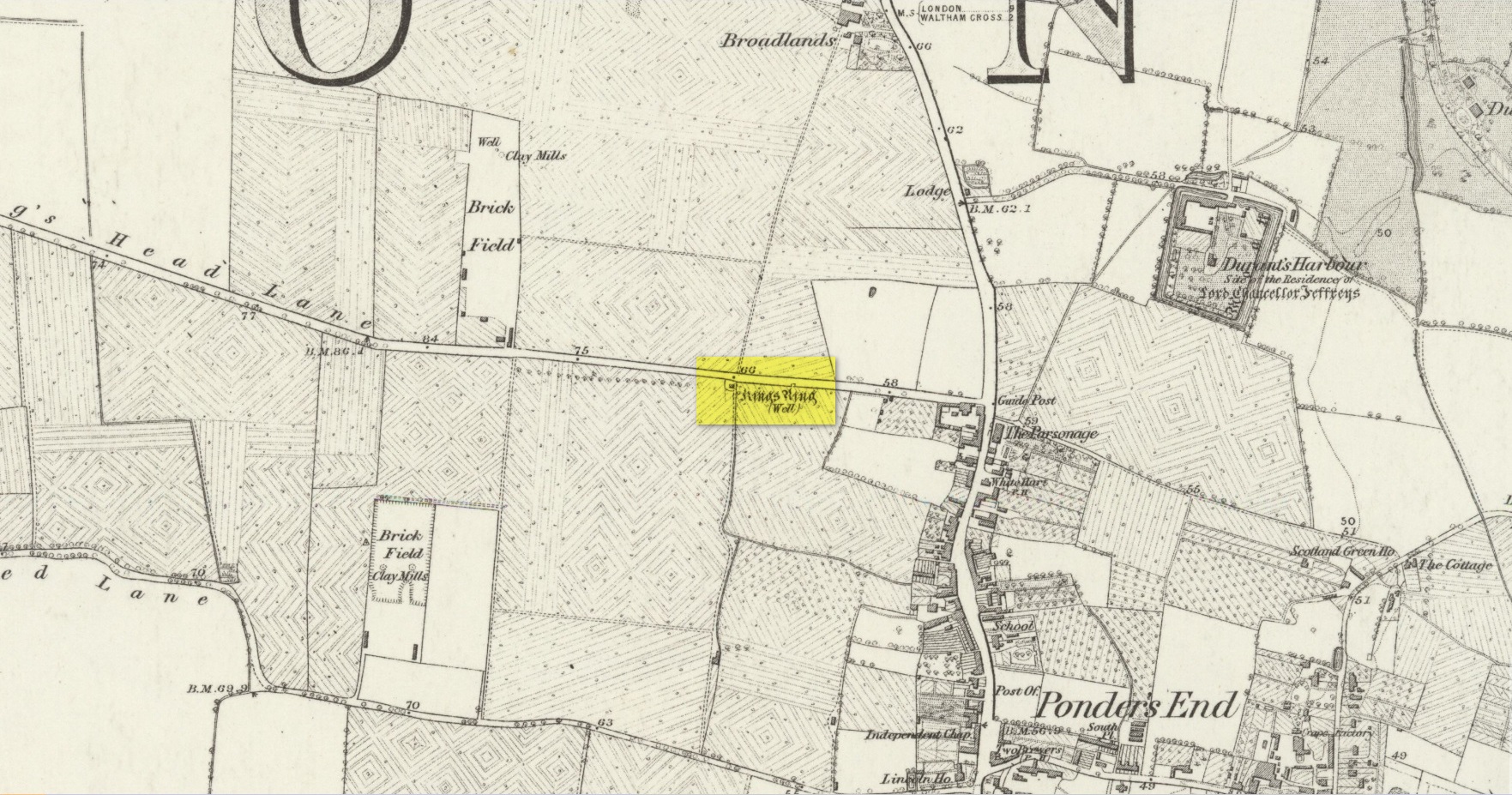
Site shown on 1879 map
Highlighted on the 1879 Ordnance Survey map, on the south-side of Southbury Road close to Ponders End, this curiously-named water source has a somewhat mundane history to it. It’s likely that an old stone conduit that was shown on John Ogilby’s 1698 road map of the area is the King’s Ring Well—although it hadn’t acquired that name at the time. It was described for the first time in Robinson’s (1823) classic work, located “on the south side of Gouldsdown-lane,”—which later became known as Nag’s Head Lane and today is Southbury Road. Anyhow, he continued telling us that here,
“there is a moat dividing two square fields. In the first there are remains of stables, barns, &c. and hollows, as of vaults, among the trees. There is a deep well, bricked, called “King Ring” or “Tim Ringer well,” (Timothy Ring was an opulent farmer who occupied the lands; and it is supposed from his arrogant manner obtained the nic-name of “King Ring.”) whose spring, it is said, never freezes nor dries up, and the water is esteemed very efficacious in disorders of the eyes.”
Robinson noted that the local drovers, “who from being so much exposed to the dust are subject to sore eyes, frequently turn up the lane to use the water, and there have been instances of children being cured of sore eyes by it after the measles.” He also alluded to a tradition that a religious house or convent once stood hereby, although he never obtained accurate information to prove his idea. If that was the case, the site may have been a holy well. The medicinal properties of the waters were repeated in Lewis’ Topographical Dictionary (1848); and again in Hodson & Ford’s (1873) subsequent survey of Enfield, emphasizing that it was “considered infallible as a remedy for inflammation of the eyes.” Sadly the well has long since been destroyed.
Acknowledgements:Huge thanks for use of the Ordnance Survey map in this site profile, reproduced with the kind permission of the National Library of Scotland.
Located in the copse known as Godwell’s Grove on the western boundary of Arkesden, there are good grounds for thinking this was a sacred well: not necessarily relating to the christian God, but what A.H. Smith (1956) described simply as, from the old English, “a (heathen) god.” Another site of the same name is found in Wiltshire. In the local survey by Parish (2010), he told that “its name suggests it is a holy well.”
In Reaney’s (1976) survey on English place-names, he looks at a number of places where the element “god” is found and explores the notion of them recording a personal name, Gode. This is evident of course, but he stated that,
“it would indeed be a remarkable coincidence if all these names…were to contain the personal-name Gode, a short form of Godric, Godwine, etc. It in inconceivable that the reference should be to the christian deity… All are situated in areas of early settlement where heathen place-names might be expected and may well contain OE god, ‘a god’.”
There is no longer any trace of the well.
References:
Parish, R.B., Holy Wells and Healing Springs of Essex, Pixyled Press: Nottingham 2010.
Reaney, P.H., The Place-Names of Essex, Cambridge University Press 1935.
Reaney, P.H., The Origin of English Place-Names, RKP: London 1976.
Smith, A.H., English Place-Name Elements – volume 1, Cambridge University Press 1956.
Robin Hood wells are numerous in Yorkshire and Derbyshire, but finding them in this neck o’ the woods is unusual (a Robin Hood’s Farm can be found nearly 14 miles south). The waters here would have had obvious importance for local peasant folk in bygone centuries, perhaps with scatterings of Beltane and Midsummer rites hereby; but it seems that records are silent on such matters. The only reference I can find of this place is in Bracken’s (1860) fascinating work on Sutton Coldfield, where he told that,
“At the extremity of the parish, near Pype, a little field is still called the Bowbearer’s Croft. Tradition says two officers of the chase, bowbearers, had a lodge there; and that their duty was to guide the travellers across the wild country. A very old cottage, that had been well built, was removed from the croft in 1828. In that neighbourhood was a fountain, called Robin Hood’s well, now enclosed within the grounds of Penns, where the natural beauties of the situation have been judiciously displayed and improved by the taste of the late proprietor, Joseph Webster.”
Marshy ground to the east of Pype Hall fed the large pond, which is one contender for the site of this lost well. What has become of it? A search in the local library archives for any old manorial maps, or the field-name maps showing Bowbearer’s would prove truly helpful in relocating this site.
References:
Bracken, L., History of the Forest and Chase of Sutton Coldfield, Simpkin Marshall: London 1860.
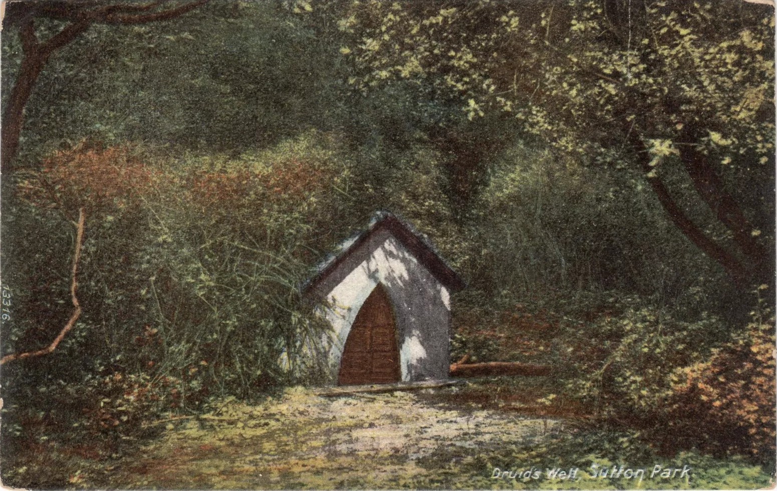
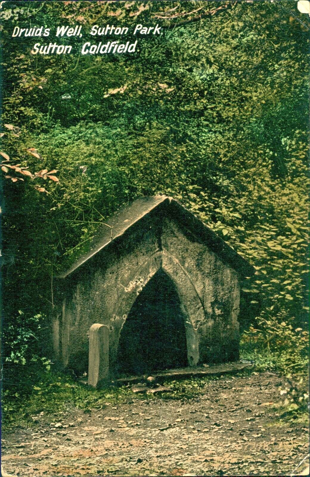
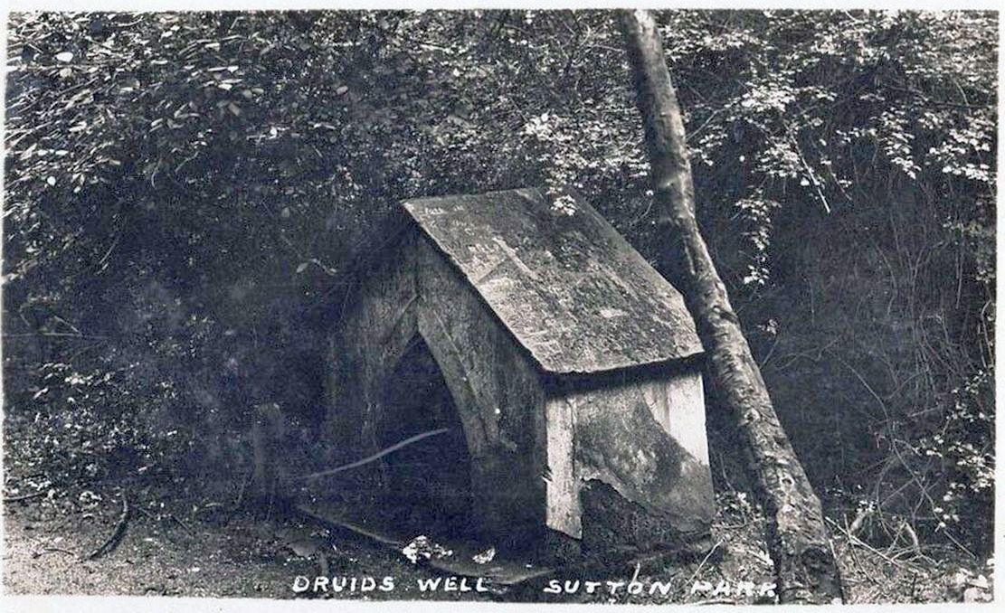
Highlighted on the 1884 Ordnance Survey map of the region and located beyond the far eastern end of Braceridge Lake, this legendary well has seen better days. A small well-house once covered the spring, but all we have left today is little more than a rectangular stone-lined concrete hole-in-the-ground where the waters collect (hopefully some local folk can bring it back to life). But in the 19th century it was well known, much frequented and maintained.
Not much seems to be known about its mythic history, as the traditions surrounding its dual pagan-christian dedication seem to have been forgotten. When the local writer Tom Burgess (1893) came to explore its history, he merely wrote:
“How it came to be called the Druids’ Well is not known, it is scarcely necessary to say that it can have no Druidical connection; it is very probable, however, that it was dedicated to Saint Mary long before the dam of Bracebridge Pool was made by Ralph Bracebridge in the reign of Henry V.”
Druids Well in 1917
Druid’s Well in 1932
Jeremy Harte (2008) suggested that this well’s druidic association may have come from a local man, William Hutton who, in the middle of the 18th century, “speculated on a druid sanctuary near Sutton Coldfield.” But before Hutton, the 17th century Staffordshire topographer, Robert Plot, suggested that an arch-druid held residence on Barr Beacon, which is less than three miles west of here. This idea was echoed by Midgley (1904) who told that Barr Beacon “is supposed to have been a Druidical shrine.” Just over three miles to the northwest, the Druid’s Heath (a place-name derived, apparently, from an old family) at Aldridge also had its own array of folklore which, perhaps, may have had something to do with this well’s association. When Roy Palmer (1976) wrote about the Druid’s Well in his folklore survey, he told that Sutton Coldfield,
“is said once to have been the seat of the arch-druid of Britain; perhaps this was his well, which was later christianized.”
So much to choose from…
References:
Bord, Janet, Holy Wells in Britain – A Guide, HOAP: Wymeswold 2008.
Bracken, L., History of the Forest and Chase of Sutton Coldfield, Simpkin Marshall: London 1860.
Harte, Jeremy, English Holy Wells – volume 2, Heart of Albion press: Wymeswold 2008.
Midgley, W., A Short History of the Town and Chase of Suton Coldfield, Midland Counties Herald: Birmingham 1904.
Palmer, Roy, The Folklore of Warwickshire, Batsford: London 1976.
Acknowledgements:Huge thanks for use of the Ordnance Survey map in this site profile, reproduced with the kind permission of the National Library of Scotland.
Sitting quietly “on the village green, where the fair is still held,” wrote Wigram (1885), “stands the base of the old market-cross, reduced to a shapeless stump, but still bearing traces of leaden setting.” Thought to be mediaeval in age, it was described as a sundial on some of the early Ordnance Survey maps which, perhaps, it may have been used as for a short period (although records are silent on the matter). Standing just three-feet tall, this old stone pillar still lives on its ancient spot, as quiet as always, keeping itself to itself…
References:
Wigram, S.R., Chronicles of the Abbey of Elstow, Parker & Co.: Oxford 1885.
Holy Well (destroyed): OS Grid Reference – SP 9848 0822
Also Known as:
St. James’ Well
Archaeology & History
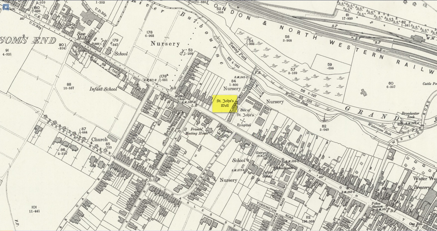
Site shown on 1897 map
Shown on the early Ordnance Survey maps of the town, Berkhamsted’s holy well was a place of some renown in bygone centuries. Today it is barely remembered. It was initially dedicated to St. James, as it was associated with a chapel dedicated to that saint close by, but it had a change of name when the legendary Brotherhood of St. John the Baptist became the new caretakers, so to speak. As a result of this, its history can be a little confusing to some folk!
In the late 12th century, pagan worship at this site came to the attention of Hugh of Grenoble, the Bishop of Lincoln, who visited the place to stop local folk performing their animistic practices (although the exact nature of such rites were not described, sadly). It didn’t work, obviously; as once the bonkers bishop had gone, local folk would have continued in their old ways, no doubt wondering who the hell the odd incomer had been who was telling them to stop doing what they had always done here at the cost of no one. And so the waters continued to be used under the mythic cover of old St James—for the time being at least.
The well later became a centre of pilgrimage and and a hospital was been built close by dedicated to St James, where leprosy was treated and the curative waters from this well were used. St James’ Day was July 25 and an annual fair was held in Berkhamsted thanks to a Royal Charter of James I in 1619. Hertfordshire traditions relating to St James Day are described in Miss Jones-Baker’s (1974) fine survey on the customs of the county. But change was a-coming when a local monk had a dream that the waters of this “pagan spring” needed to be blessed and dedicated to the virtues of St. John the Evangelist and a shrine built where pilgrims could worship and be healed. And as Jones-Baker (1977) told us,
“The water of St John’s Well were thought to cure a variety of diseases; among these leprosy and scrofula (the King’s Evil) as well as sore eyes. There was also a persistent belief that clothing washed in its waters would impart good health to the wearers.”
In the period when the Protestant Reformation occurred, the well and its immediate surrounds apparently became derelict and overgrown. The Old Ways returned and local folk began to visit the waters again at night and the animistic rituals that would have been taken to other secret places returned to St. John’s Well. In this period a local physician, a Dr. Woodhouse, used the sacred waters as part of magickal rites to exorcise evil spirits!
In spite of the local authorities declaring in 1865 that the water was “unfit for drinking”, local folk later told otherwise. Its waters were still being used in the 20th century and its traditions no doubt retained. As the local writer Dora Fry (1954) told us:
“The families dwelling in the cottages at the Bulbourne end of the lane, just below St John’s Spring, were all remarkably healthy… Some time after the town got its first waterworks (and) the local authorities declared that the well’s water was to be used only for the gardens… but I remember as a child drinking the water from the main spring and its coolness and freshness were delectable on a hot summer afternoon.”
The well was still visible up until the 1930s, when its waters ran down a shallow channel along St John Well’s Lane, but then a shop was built above the site and the well has been lost forever.
References:
Bord, Janet & Colin, Sacred Waters, Granada: London 1985.
Acknowledgements:Huge thanks for use of the Ordnance Survey map in this site profile, reproduced with the kind permission of the National Library of Scotland.
About mile south of Northchurch, on the far side of the A41 dual carriageway, somewhere past the old crossroads (or perhaps even at the crossing) an ancient tree lived—and truly lived in the minds of local people, for perhaps a thousand years or so. Mentioned in the Lay Subsidy Rolls in 1307, the Cross Oak gave its name to the old building that once stood in the trees and the hill itself, at the place now known as Oak Corner. Whether or not a “cross” of any form was set up by this old oak, records are silent on the matter. Its heathen ways however, were pretty renowned! (a plaque should be mounted here)
Folklore
The first reference I’ve found of this place is in William Black’s (1883) folklore survey where he told that “certain oak trees at Berkhampstead, in Hertfordshire, were long famous for the cure of ague”—ague being an intense fever or even malaria. But a few years later when the local historian Henry Nash (1890) wrote about this place, he told that there was only one tree that was renowned for such curative traditions, that being the Cross Oak. He gave us the longest account of the place, coming from the old tongues who knew of it when they were young—and it had it’s very own ritual which, if abided by, would cure a person of their malady. “The legend ran thus”, wrote Mr Nash:
“Any one suffering from this disease was to proceed, with the assistance of a friend, to the old oak tree, known as Cross Oak, then to bore a small hole in the said tree, gather up a lock of the patient’s hair and make it fast in the hole with a peg, the patient then to tear himself from the tree, leaving the lock behind, and the disease was to disappear.
“This process was found to be rather a trying one for a weak patient, and by some authority unknown the practice was considerably modified. It was found to be equally efficacious to remove a lock of hair by gentle means, and convey it to the tree and peg it in securely, and with the necessary amount of faith the result was generally satisfactory. This is no mere fiction, as the old tree with its innumerable peg-holes was able to testify. This celebrated tree, like many other celebrities, has vanished, and another occupies its place, but whether it possesses the same healing virtues as its predecessor is doubtful. It is however a curious coincidence, that the bane and the antidote have passed away together.”
The lore of this magickal tree even found its way into one of J.G. Frazer’s (1933) volumes of The Golden Bough, where he told how the “transference of the malady to the tree was simple but painful.”
Traditions such as this are found in many aboriginal cultures from different parts of the world, where the spirit of the tree (or stone, or well…) will take on the illness of the person for an offering from the afflicted person: basic sympathetic magick, as it’s known. Our Earth is alive!
References:
Black, William G., Folk Medicine, Folk-lore Society: London 1883.
Frazer, James G., The Scapegoat, MacMillan: London 1933.
Jones-Baker, Doris, The Folklore of Hertfordshire, B.T. Batsford: London 1977.
Nash, Henry, Reminiscences of Berkhamsted, W. Cooper & Nephews: Berkhamsted 1890.
Acknowledgements:Huge thanks for use of the Ordnance Survey map in this site profile, reproduced with the kind permission of the National Library of Scotland.