From the Cow & Calf car-park, walk towards and past the gigantic Calf rock, swerving round the fallen mass of rocks and into the trees at the back. Walk uphill to the Hanging Stones cup and ring stones, then keep heading—down the slope then back up the next one—west, for barely 100 yards until you’re on the level ground again, following the footpath alongside the heather. Barely 50 yards along, keep your eyes peeled in the heather for a low flat rock just a few yards in. Forage around and you’ll find it.
Archaeology & History
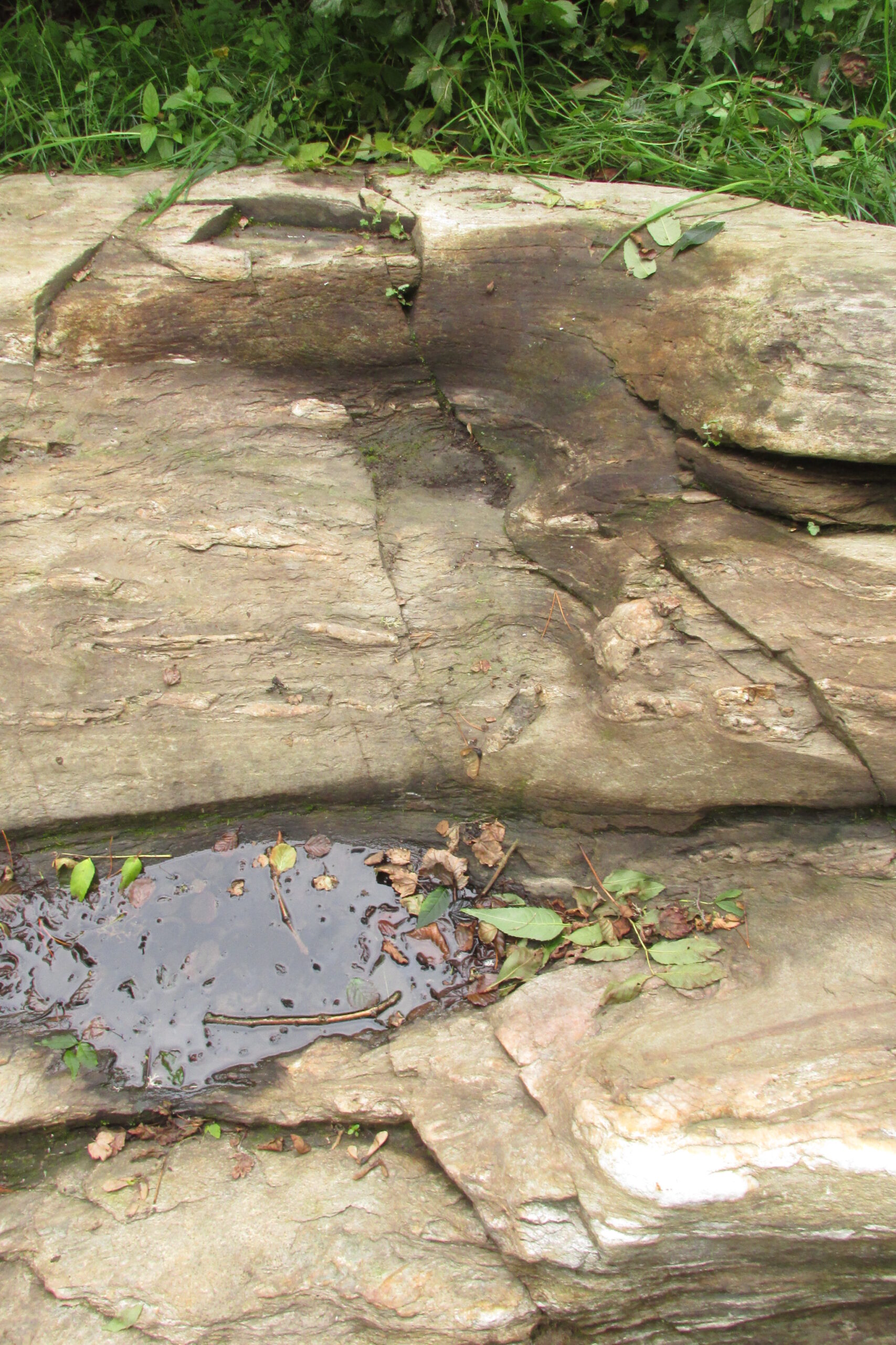
You’ll no doubt be seeing this carving after you’ve visited the impressive Hanging Stones petroglyphs 150 yards to the east. And you’ll probably be disappointed in its lack of visual grandeur when compared to its more ornate eastern neighbour. But the petroglyph fans among you should give it your attention.
Hedges 1986 sketchLooking to the SE
When the dawn or evening daylight cuts across the rock, the design looks much better than at sun high, perhaps telling us that the message of the stone coincided with those periods of the day. The gentle folds of the stone itself morph into the carving: evening and morning light cutting subtle shadowy folds across the rock, giving it an organic texture that our aboriginal ancestors told to be a vital essence of stone itself. The two small clusters of cup-marks upon this stone become greater than their basic design when brushed with the shadows and glows of a sunset. And when our aboriginal peoples painted them in ochre and other colours, an even greater mythos emerged—but sadly it is forgotten here….
When looked at with the simplistic eyes of the archaeo-mind, this and its compatriots are little more than a number of marks on lifeless rocks. This stone for example was described in John Hedges’ (1986) survey as being just “two groups of four and five cups and grooves”—nothing more—with naught but an echo in Boughey & Vickerman’s (2003) later work. The carving has neighbours even more basic in the heather close by…
References:
Boughey, Keith & Vickerman, E.A., Prehistoric Rock Art of the West Riding, WYAS: Wakefield 2003.
Hedges, John (ed.), The Carved Rocks on Rombalds Moor, WYMCC: Wakefield 1986.
Standing Stone (destroyed): OS Grid Reference – SK 5779 0644
Also Known as:
Little John’s Stone
Archaeology & History
Nichols 1804 drawing
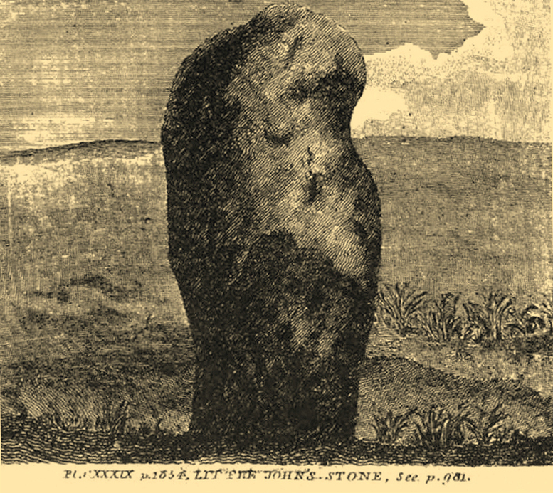
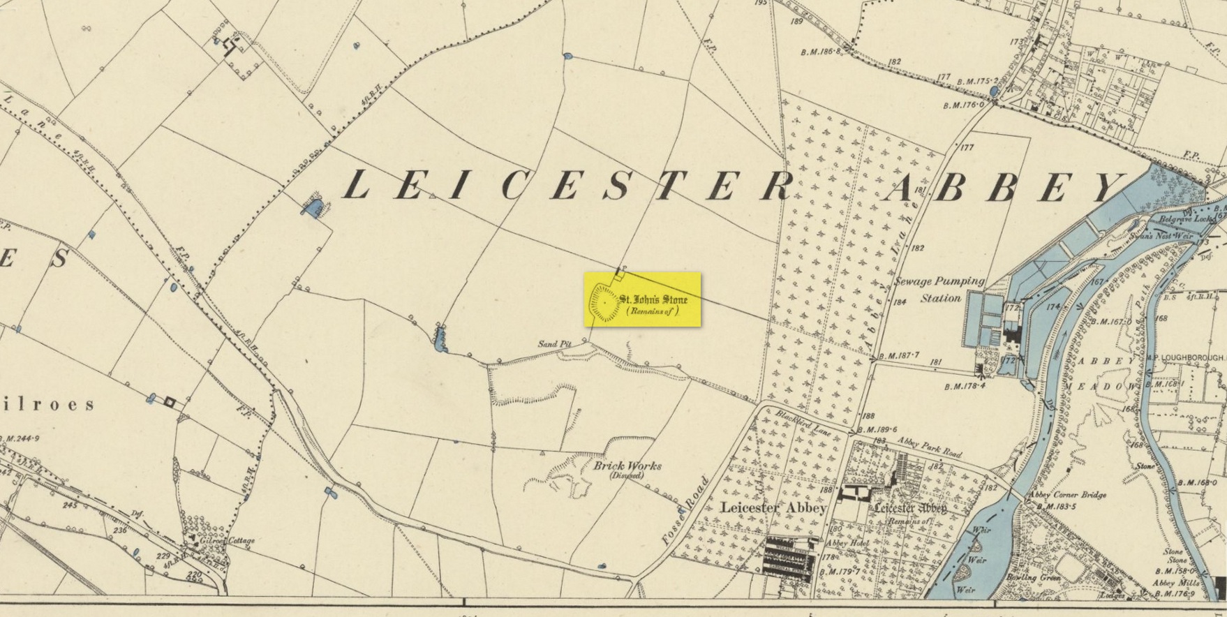
This once impressive megalithic site was first mentioned in 1381, giving its name to the field Johnstone Close. Shown on the early Ordnance Survey maps standing on a raised portion of land in an area north of the modern town centre, not far from the Abbey, its destruction had been a slow one until it finally disappeared about a hundred years ago. One of the early descriptions of it was by John Nichols (1804) in his immense series of works on the county. He called it ‘Little John’s Stone’* and gave us the first known illustration of the monolith (right), telling it to be “7 feet 2 inches high, and 11 feet 3 inches wide”—although he obviously meant circumference and not ‘wide’, as his illustration clearly shows. Although this slight error was perhaps the reason that Historic England proclaimed the stone to have been little more than “a natural feature”—which it clearly wasn’t.
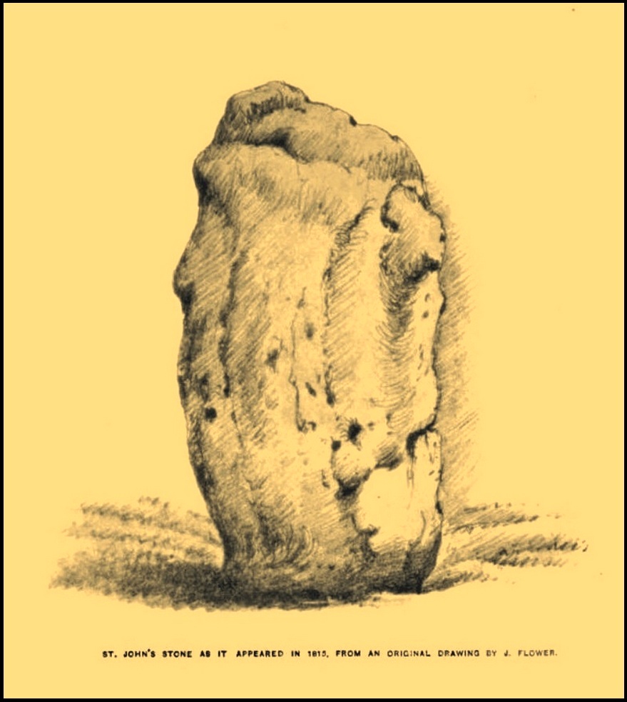
Stone shown on 1885 mapJohn Flower’s 1815 sketch
The stone stood in what Nichols called “a kind of amphitheatre”, and what James Hollings (1855) subsequently called a sloping hollow which, he thought, had “been excavated by the hand of man.” It was located “in a meadow, a little to the west of the Fosse-way,” he said, “not far from the ancient boundary wall of the Abbey of St. Mary de Pratis.” There’s little doubt it was a prehistoric standing stone. Hollings described it as standing erect and told it to be one of those “monolithic erections, or hoar stones, anciently sanctified by the rites of Druidic worship,” comparing it to “similar rude columns” in Cornwall, Scotland and just about everywhere! He also told that it was a place of summer solstice gatherings, being
“in the memory of many living, annually visited about the time of Midsummer by numerous parties from the town in pursuance of a custom of unknown antiquity.”
When James Kelly (1884) wrote about the stone, little was left of it save at ground level. He repeated much of what Hollings had previously written, but had a few notes of his own. One related to the local mayor and MP for Leicester, Mr Richard Harris, dated January 1853, who told him:
“When a boy, he had frequently played on the spot where it was customary for the children to resort to dance round the stone (which he thought was about eight feet high), to climb upon it and to roll down the hill by which the stone is in part, encircled. The children were careful to leave before dark, as it was believed that at midnight the fairies assembled and danced round the stone.”
More than fifty years later when Mrs Johnson (1906) wrote about the place she said that only a small section of the stone still remained, just “a few inches above the earth.” It had been incrementally “broken to pieces down to the surface of the ground and used to mend the road.” (Kelly 1884) Alice Dryden (1911) lamented its gradual demise in size, summarizing:
“At the beginning of the nineteenth century it was about 7 feet high, but by the year 1835 it had become reduced to about 3 feet. In 1874, according to the British Association’s Report, it was about 2 feet high, and it has now completely disappeared.”
Local tradition tells that some small pieces of St John’s Stone were moved to the nearby St. Luke’s church, where bits of it can still be seen. Has anyone found them?
More recent lore has attributed St John’s Stone to have been aligned with the Humber Stone (SK 62416 07095) nearly 3 miles to the east, in a summer solstice line—but it’s nowhere near it! A similar astronomical attempt said that the two stones lined up with the Beltane sunrise: this is a little closer, but it still doesn’t work. The equinox sunrise is closer still, but whether these two stones were even intervisible is questionable.
* this was probably the name it was known by local people who frequented the nearby Robin Hood public house (long gone); its saintly dedication being less important in the minds of Leicester’s indigenous folk.
References:
Cox, Barrie, The Place-Names of Leicestershire – volume 1, EPNS: Nottingham 1998.
Devereux, Paul, “The Forgotten Heart of Albion,” in The Ley Hunter, no.66, 1975.
Dryden, Alice, Memorials of Old Leicestershire, George Allen & Sons: London 1911.
Hollings, James Francis, Roman Leicester, LLPS: Leicester 1855.
Kelly, William, Royal Progresses and Visits to Leicester, Samuel Clarke: Leicester 1884.
Nichols, John, The History and Antiquities of Leicestershire – volume 3: part 2, J. Nichols: London 1804.
Trubshaw, Bob, Standing Stones and Markstones of Leicestershire, Heart of Albion Press 1991.
Acknowledgements:Huge thanks for use of the Ordnance Survey map in this site profile, reproduced with the kind permission of the National Library of Scotland.
The exact location of this site seems privy to a select few and has remained that way since its existence appeared in print in the 19th century. It was first mentioned by Arthur Mitchell (1874) following a holiday that he’d had in the area in the early 1870s. He’d visited a petroglyph at Laggan with a Mr David Ross and when he returned home received a letter from him that told how,
“he had heard from Mr M’Bain of Auchterblair of two huge granite boulders, situated on a shelving rock over an abyss on the Loch Avon side of Cairngorm, with hand-made cups on them about a foot wide and correspondingly deep.”
They were subsequently visited by Thomas Wise (1884) a few years later, who told how these huge granite boulders were,
“20 feet in height,” upon which “there are four basins, 1 foot, or 1 foot and a-half long, and 6 inches wide at the top, rounding off to 1 inch in the bottom.”
Initially Mr Mitchell (1874) was cautious in associating these carved basins with cup-marked stones—and indeed, we concur with this—but seemed to have changed his opinion when he wrote about them a few years later (Mitchell 1881). But it’s the folklore attached to this site that intrigued him – and myself…
Folklore
The traditions attached to this site will be recognised by all students of animism and folklore. Arthur Mitchell (1874) was informed how the carved bowls in the stone helped infertile women and how “sitting on (them) is said to be efficacious in cases of barrenness.” Their importance was highlighted in the fact that there had been “pilgrimages to them undertaken within the memory of people still living.”
This was affirmed by Thomas Wise (1884) who told that,
“They are supposed to be efficacious in barrenness, and people still living remember pilgrims coming to sit upon them for some time, that they might obtain what they wished. A visit to them was by no means an easy task, as the ascent was difficult, and to sit on them required a steady head, as they are on the brink of a rock overhanging a precipice. These basins are the “woman’s stone” mentioned by Tennant. They are supposed to be the resting place or throne of a certain fairy queen; but however efficacious they may have been, they have lost much of their celebrity; and as the shepherd, who acted as guide to the pilgrims, is dead, and has left no successor, they are now rarely visited.”
Does anyone know the whereabouts of this heathen magickal site? If you happen to find it, see if you can get a good photo or two and let us know on our Facebook group.
Take the road to Auchlyne from Killin which follows the north side of the River Dochart, and on the edge of the village the stone will be seen on the left hand side behind a hedge, opposite the entrance to ‘Springburn’.
Archaeology & History
The chair is mentioned in Rev. Gillies’ exemplary work, In Famed Breadalbane (1938):
‘St. Fillan would appear to have had a great liking for stone seats. Besides the one already mentioned…there is..a..flat stone on the top of a knoll about a mile to the west of the village, and on the north side of the river, on which he is said to have sat and taught‘
St Fillan’s Chair, ‘twixt road and riverThe ‘seat’, facing the River Dochart
Two local ladies told us that the Chair had recently been uncovered from the vegetation. It is a flattish earth-fast slab of rock, which has on the right hand side a seat indentation, which faces the river bank about 12 feet away. Its proximity to the river bank would seem to limit its use as a preaching pulpit, and yet, well over a millennium after the death of Fillan, his ‘Chair’ is still remembered. Did the Chair serve another purpose, a purpose that long preceded Fillan and Christianity?
Here at Killin we are in an area of Scotland where Christianity was for long a veil worn very lightly over long-held ancient animistic beliefs and customs. Indeed in the early nineteenth century, missionaries were sent in the face of considerable local opposition by the Haldanes into Gaelic speaking Breadalbane to try to convert the locals to Christianity.
St Fillan and other saints had it seems become the named facilitators for healing at ancient places on behalf of the incoming religion from the Middle East. To the west of Killin, there are the St Fillan’s Pools at Auchtertyre near Tyndrum, where he is reputed to have cured madness but which continued to be used for that purpose until the late eighteenth century at least. There are stones for preventing measles and whooping cough near Killin that are still known and pointed out. So what of our chair?
There is a nineteenth century story of a chair of St Fiacre (Irish born like Fillan) at the village church of St Fiacre near Monceaux in France being used to ‘confer fecundity upon women who sit upon it ‘. The shape and proximity to the river may otherwise suggest St Fillan’s Chair was a birthing Chair? Maybe some very old locals still know the true story of this Chair, but would they tell it?
References:
Anon., Phallic Worship – a Description of the Mysteries of the Sex Worship of the Ancients, privately Printed: London 1880.
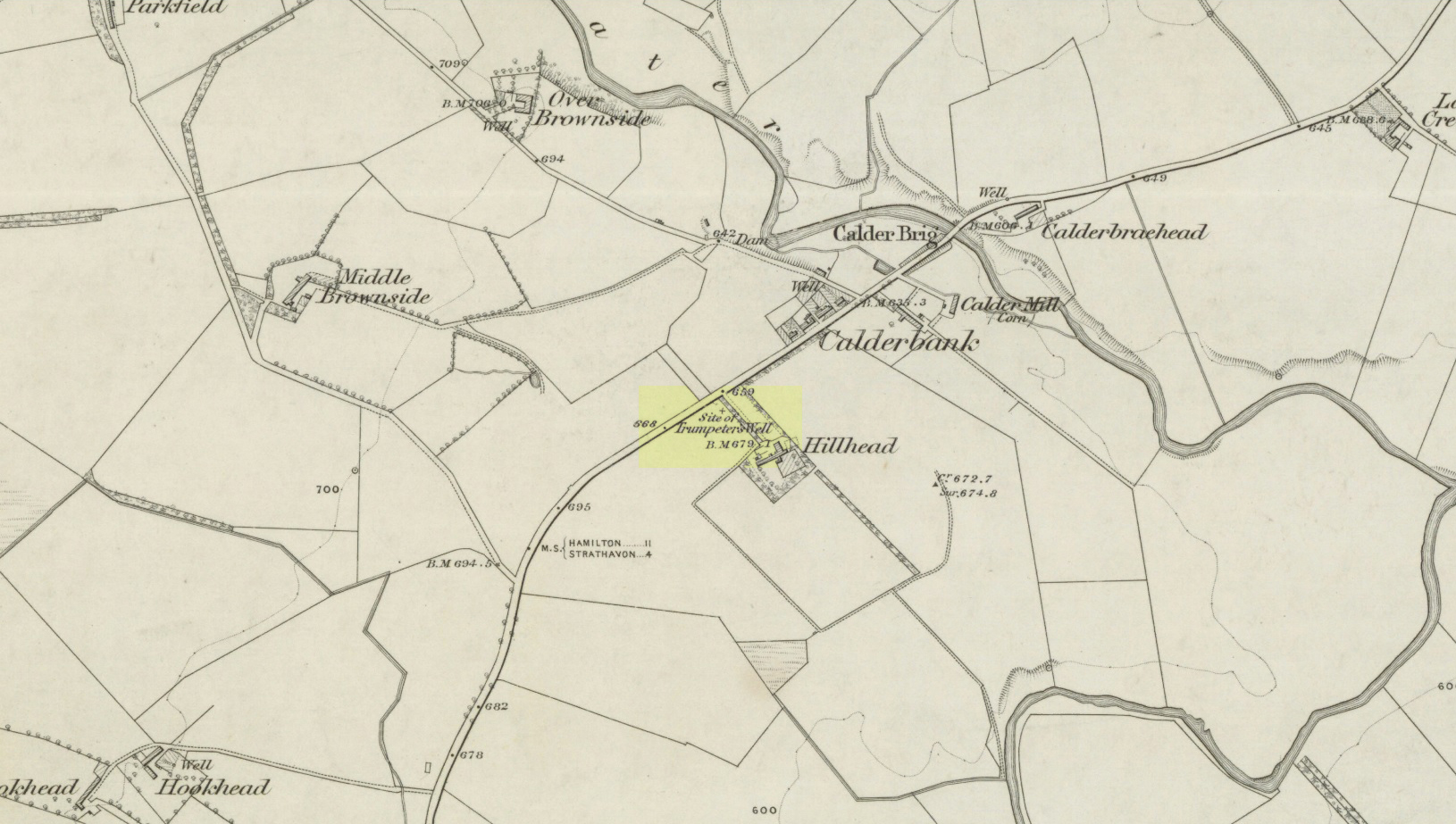
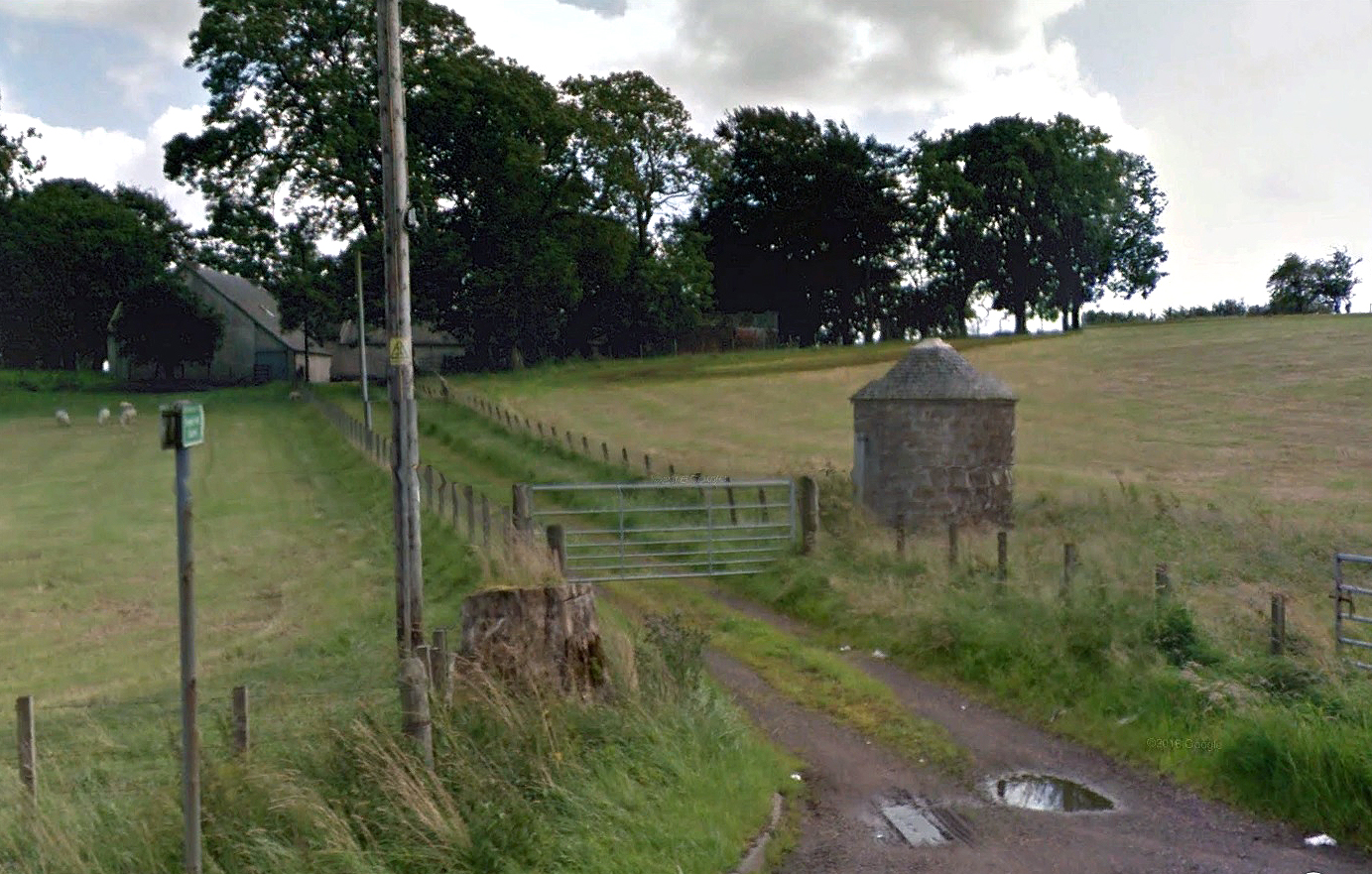
Take the A71 road southwest out of Strathaven as if you’re heading to Kilmarnock. After 2½ miles (4.1km) you reach the tiny hamlet of Caldermill (be careful or you’ll truly miss it!). As you go out of the hamlet, on your left there’s a track up to Hillhead Farm with the small but tell-tale signpost saying ‘Trumpeter’s Well’ and the small dome-shaped stone monument in the field is what yer looking for. If you’re coming from the Kilmarnock side, when you reach the Caldermill sign, it’s in the field immediately to your right. Y’ can’t really miss it.
Archaeology & History
When the site was surveyed by the Ordnance Survey lads in the 1850s, the water supply had completely run dry. It was later revived and the nine-foot tall circular stone building built to commemorate its history. The water apparently now runs within the building, being supplied from Hillhead Farm.
Trumpeters Well, Caldermill
Folklore
The well is said to have gained its name after the local Battle of Drumclog (1679), when one rich Tory known as John Graham of Claverhouse was retreating for fear of his life; and because his own horse had been killed, the coward stole the horse of his young fourteen-year-old trumpeter. In doing so, the young lad was subsequently killed and his body was thrown down the well. Tradition also tells that other soldiers were buried in the same field.
References:
Campbell, J. Ramsey, My Ain, My Native Tour – Stra’ven, J.M. Bryson: Strathaven 1943.
Holy Well (destroyed): OS Grid Reference – NS 6983 4138
Archaeology & History
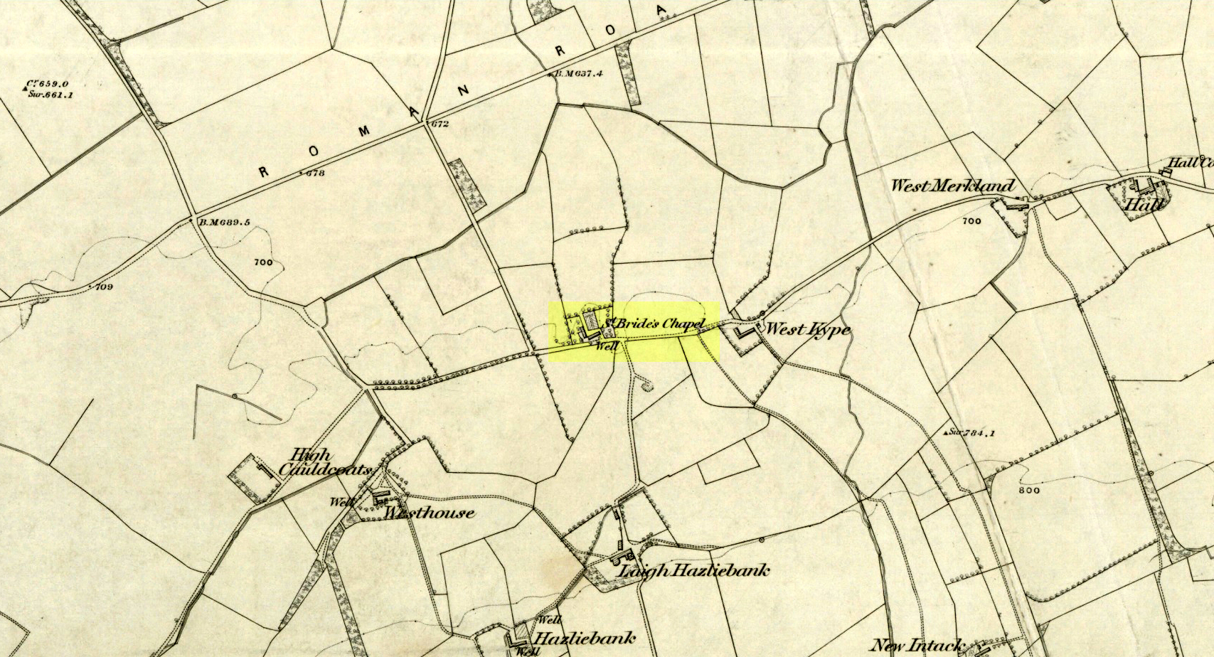
St Brides Chapel & Well on the 1864 OS-map
Shown on the 1864 OS map of the area as a ‘Well’ just at the front of St Bride’s Chapel—now a very pleasant old cottage—peasants and pilgrims would stop for both refreshment and ritual here as they walked down High Kype Road. Although the chapel was described in church records of January 1542 as being on the lands of Little Kype, close to the settlement of St Bride, there seems to be very little known about the history or traditions of the well. If anyone has further information on this site, please let us know.
Folklore
Bride or Brigit has her origins in early British myth and legend, primarily from Scotland and Ireland. Her saint’s day is February 1, or the heathen Imbolc (also known as Candlemas). Although in christian lore St. Bride was born around 450 AD in Ireland and her father a Prince of Ulster, legend tells that her step-father (more probably a teacher) was a druid and her ‘saintly’ abilities as they were later described are simply attributes from this shamanic pantheon. Legends—christian and otherwise—describe Her as the friend of animals; possessor of a magickal cloak; a magickian and a healer; and whose ‘spirit’ or genius loci became attached to ‘sacred sites’ in the natural world, not the christian renunciation of it. St Bride was one of the primal faces of the great prima Mater known as the Cailleach: the greater Gaelic deity of Earth’s natural cycles, whose changing seasons would also alter Her names, faces and clothes, as Her body moved annually through the rhythms of the year. Bride was (and is) ostensibly an ecological deity, with humans intrinsically a part of such a model, not a part from it, in contrast to the flawed judaeo-christian theology.
References:
Paul, J.B. & Thomson, J.M., Registrum Magni Sigilli Regum Scotorum: The Register of the Great Seal of Scotland AD 1513 – 1546, HMGRH: Edinburgh 1883.
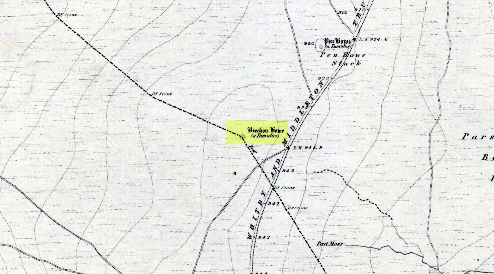
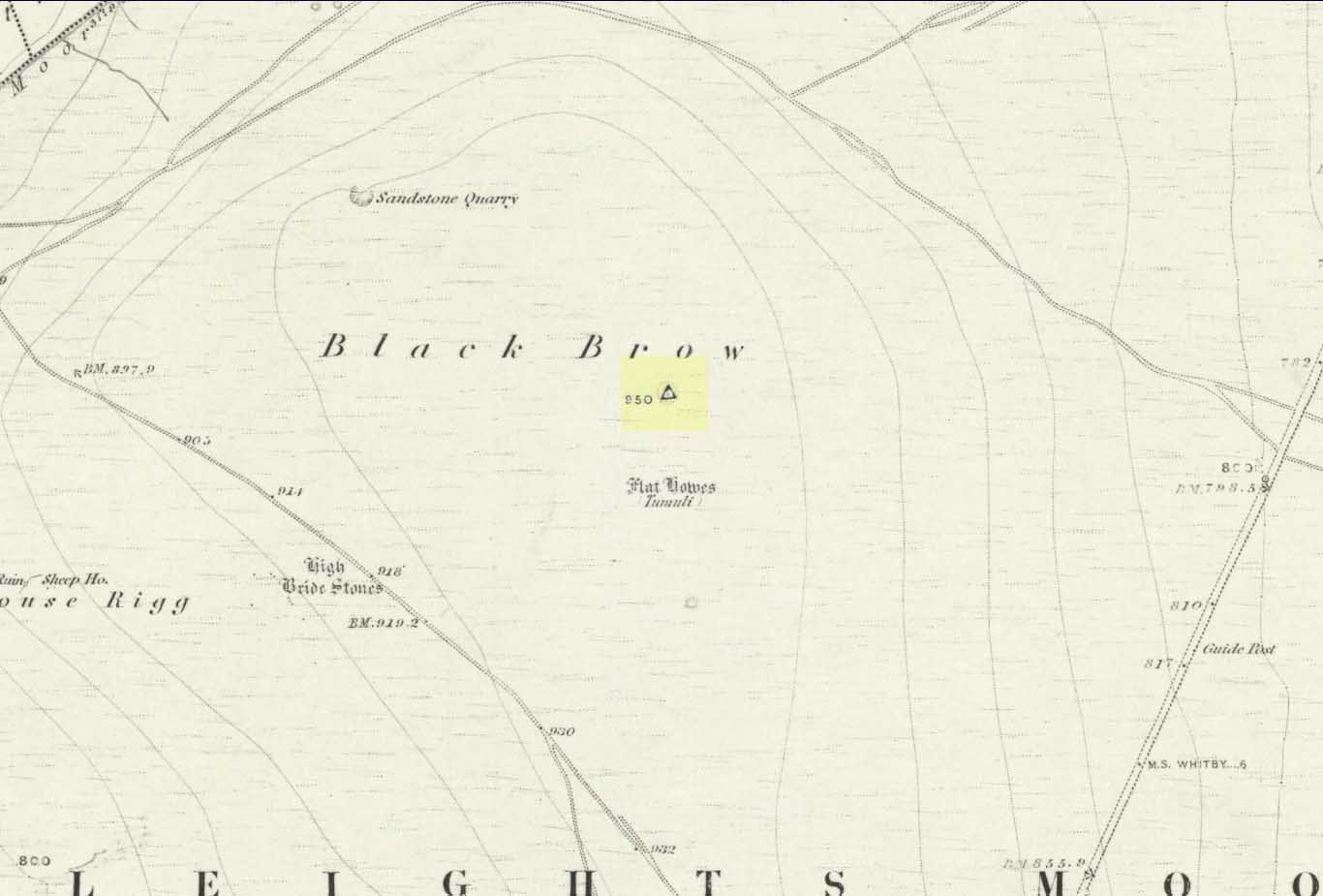
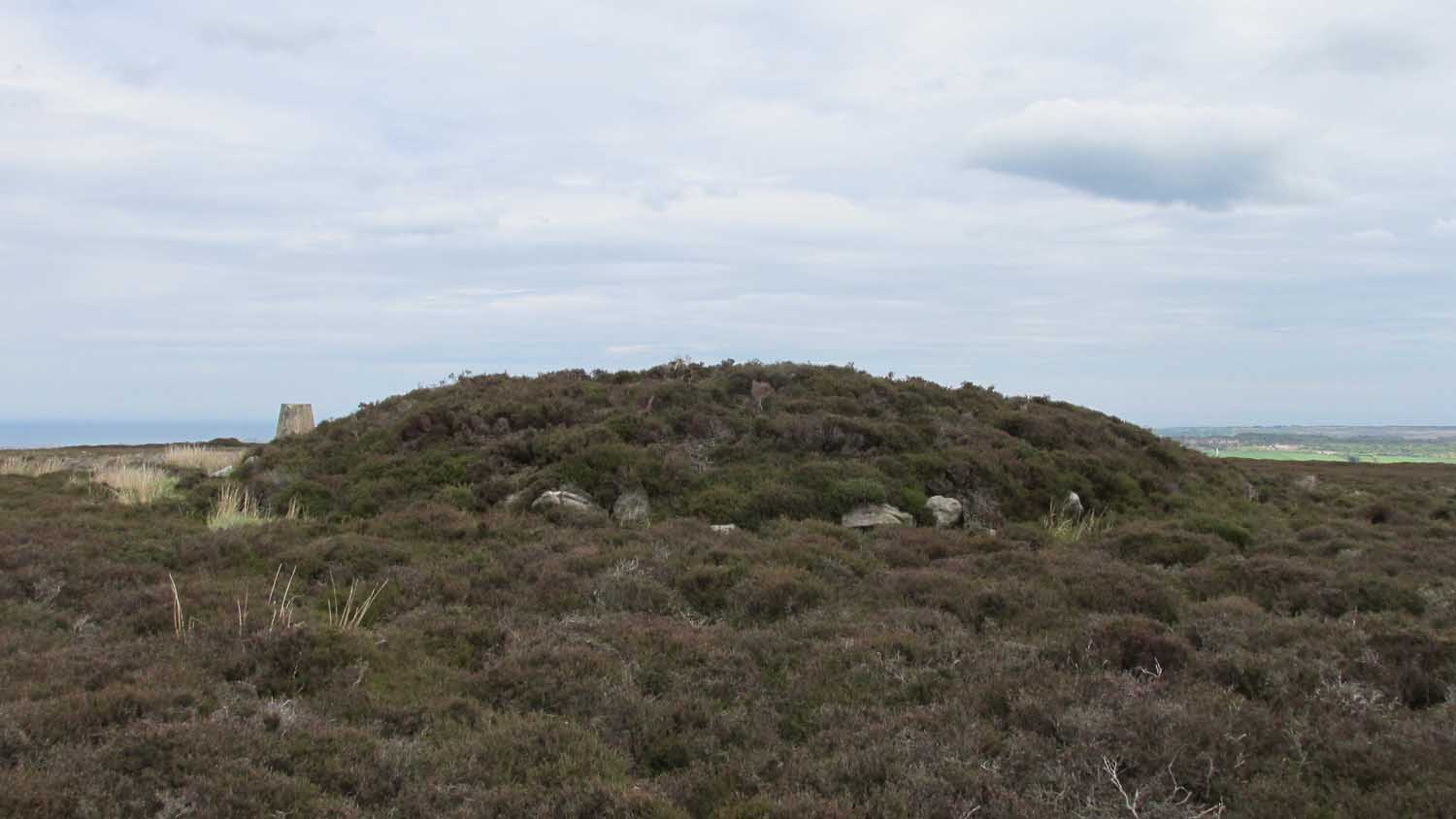
Along the A169 road between Sleights and Pickering, some two miles south of Sleights at the highest point on the moors just above the west side of the road, you’ll see a large mound with what looks like a standing stone on top of it. A minor road turns off the A169 at this point, heading southeast, and the large mound is 150 yards from the roadside. You can’t really miss it!
Archaeology & History
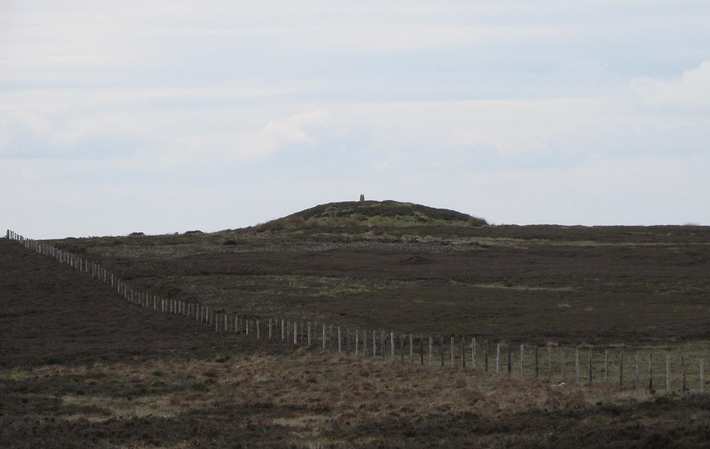
Shown on the first OS map of the area in 1853, this conspicuous prehistoric tomb surmounted by a relatively recent boundary stone, sits at the highest point on the moors in these parts. Despite this (as with others on these moors), very little has been written about the place and it has received only minimal attention in archaeology tomes. Even the renowned pen of Frank Elgee (1912; 1930) gave it only passing mention. Perhaps it aint a bad thing to be honest.
Breckon Howe, from the south
As well as being conspicuous, it’s large. Rising some six feet above the natural ground level, it measures 26 yards across its east-west axis, and 29 yards north-south, with a rough circumference of 88 yards. The boundary stone that surmounts its crown sits in a hollow that looks like it was opened up a century or two ago by antiquarians (much like ourselves). But its position of the tomb in the landscape that is most striking. The view from here is considerable, having a clear 360º view for many miles around. Other prehistoric tombs can be seen from here, but more importantly this tomb can be seen on the skyline from many others. This was probably a deliberate feature intended by its builders–and it’s not uncommon, as many of our upland regions are crowned with ancient tombs like Breckon Howe. In all likelihood this would have been the resting place of some important ancestral figure: a tribal elder or a shaman, whose spirit after death could view and travel across the landscape they inhabited in life.
Although the tomb presently sits amidst an endless sea of heather (Calluna vulgaris) typical of moorland across our northern lands, the name of the site ‘breckon’, according to George Young (1817) derives from the dialect word meaning ferns or bracken. This is echoed in Francis Kildale’s (1855) local dialect study and subsequently in Joseph Wright’s (1898) unequalled magnum opus.
Folklore
In the early 19th century, one George Calvert who lived in the area, collected as much folklore as he could, as it was dying off with the coming of the Church. One such piece told that there was once a hob who lived by this old tomb. A hob is generally known as a supernatural creature, but in this area it can also be a medicine man. Some hobs were good, others were malicious. We know not what type of hob lived lived here, but Calvert simply told us there used to be “T’ Hob of Brackken Howe”. Nowt more! It would be good to find the story behind this old character, if it hasn’t been lost entirely…
References:
Elgee, Frank, Early Man in Northeast Yorkshire, Frank Bellows: Gloucester 1930.
Elgee, Frank, The Moorlands of North-Eastern Yorkshire, A. Brown: London 1912.
Kildale, Francis, A Glossary of Yorkshire Words and Phrases Collected in Whitby and the Nieghbourhood, J.R. Smith: London 1855.
Home, Gordon, The Evolution of an English Town, J.M. Dent: London 1905.
Wright, Joseph, English Dialect Dictionary – volume 1, .Henry Frowde: London 1898.
Young, George, A History of Whitby and Streoneshalh Abbey – volume 2, Clarke & Medd: Whitby 1817.
Acknowledgements: A huge thanks to Lindsay Mitchell for getting us up to see this great tomb and its companion.
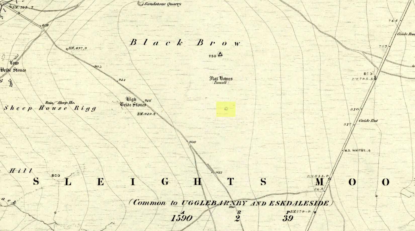
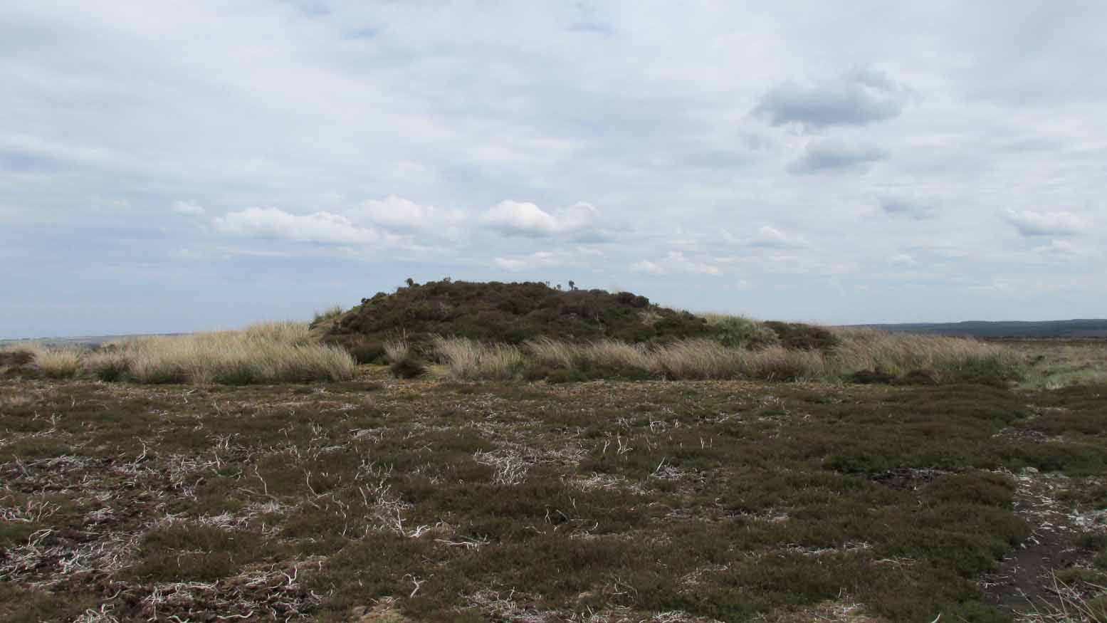
Along the A169 road that runs may miles from Whitby to Pickering, as you go through the small town of Sleights, the road gets steep for a mile or so, until you reach the moorland tops, where the road runs dead straight. After 1.2 miles (1.93km) along the straight road, a small minor road is to your right. Go along here for literally half-a-mile (0.8km) where you’ll see a small dirt-track on your right, with a locked gate. There’s room to park here. Walk straight onto the moor towards the large rounded mound about 200 yards northeast. That’s it!
Archaeology & History
Highlighted as a blip on the 1853 OS-map (see above) 250 yards south of Flat Howe (1), this is the slightly smaller of the two prehistoric cairns on this flat piece of moorland (which covered in scattered woodland at the time of its construction). It has been severely robbed of stones by some land-owning fuckwits in the 19th century, who saw fit to build a shooting hut into the tomb itself! Knob-heads! As a result, much of the content of the cairn has been severely depleted, with only its western side having any real height to it.
Flat Howe 2 looking south (photo, James Elkington)Flat Howe 2, looking east
Just like Flat Howe 1, it seems that it’s never been excavated, so we can only guess about how old it is; though it is very probably Bronze Age. The cairn is roughly 25 yards across and oval in form, but was probably more circular before those morons built their hunting lodge into it. Its western side stands some 4-5 feet tall, which was probably the uniform height all round it before it was vandalized. A few yards to the south is what may be a cup-marking on one of the flat earthfast rocks, although I’m slightly sceptical of it.
The position of the site in the landscape is a fine one: living on a large flat open expanse of land, which was probably cleared of some trees when it was first built, allowing for a very wide view in all directions, just like its companion 250 yards to the north. Well worth checking out.
Folklore
It’s worth repeating the myth we have of a place on Sleights Moor that I’ve also cited in the Flat Howe 1 site profile. Although we have nothing specific relating to this tomb, an olde creation myth tells us that the local giants, Wade and his wife Bel, left their young son (whose name seems to have been forgotten) somewhere on Sleights Moor (which aint a big place). The story was first written down by George Young (1817) in his magnum opus on Whitby and the tale was subsequently re-told by many others – Mrs Gutch (1901) for one:
“Young Wade, even when an infant, could throw a rock several tons weight to a vast distance; for one day when his mother was milking her cow near Swarthoue, the child, whom she had left on Sleights moor, became impatient for the breast, and seizing a stone of vast size, heaved it across the valley in wrath, and hit his mother with such violence, that though she was not materially hurt, her body made an impression on the stone which remained indelible, till the stone itself was broken up, a few years ago, to mend the highways!”
This rock was Bel’s Rock, whose exact location seems to have been lost.
References:
Elgee, Frank, Early Man in Northeast Yorkshire, Frank Bellows: Gloucester 1930.
Elgee, Frank, The Moorlands of North-Eastern Yorkshire, A. Brown: London 1912.
Grinsell, Leslie V., The Ancient Burial Mounds of England, Methuen: London 1936.
Gutch, Mrs, County Folk Lore – volume 2: Examples of Printed Folk-lore Concerning the North Riding of Yorkshire, York and the Ainsty, David Nutt: London 1901.
Jeffrey, P. Shaw, Whitby Lore and Legend, Home: Whitby 1923.
Roberts, Anthony, Sowers of Thunder, Rider: London 1978.
Smith, A.H., The Place-Names of the North Riding of Yorkshire, Cambridge University Press 1928.
Young, George, A History of Whitby and Streoneshalh Abbey – volume 2, Clarke & Medd: Whitby 1817.
Acknowledgements: A huge thanks to Lindsay Mitchell for getting us up to see this great tomb and its companion; and to James Elkington for use of the photograph.
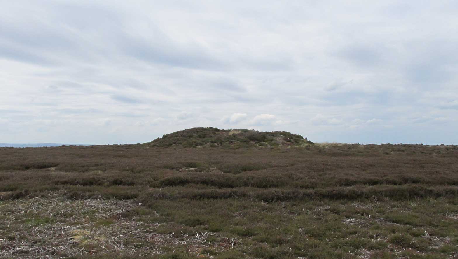
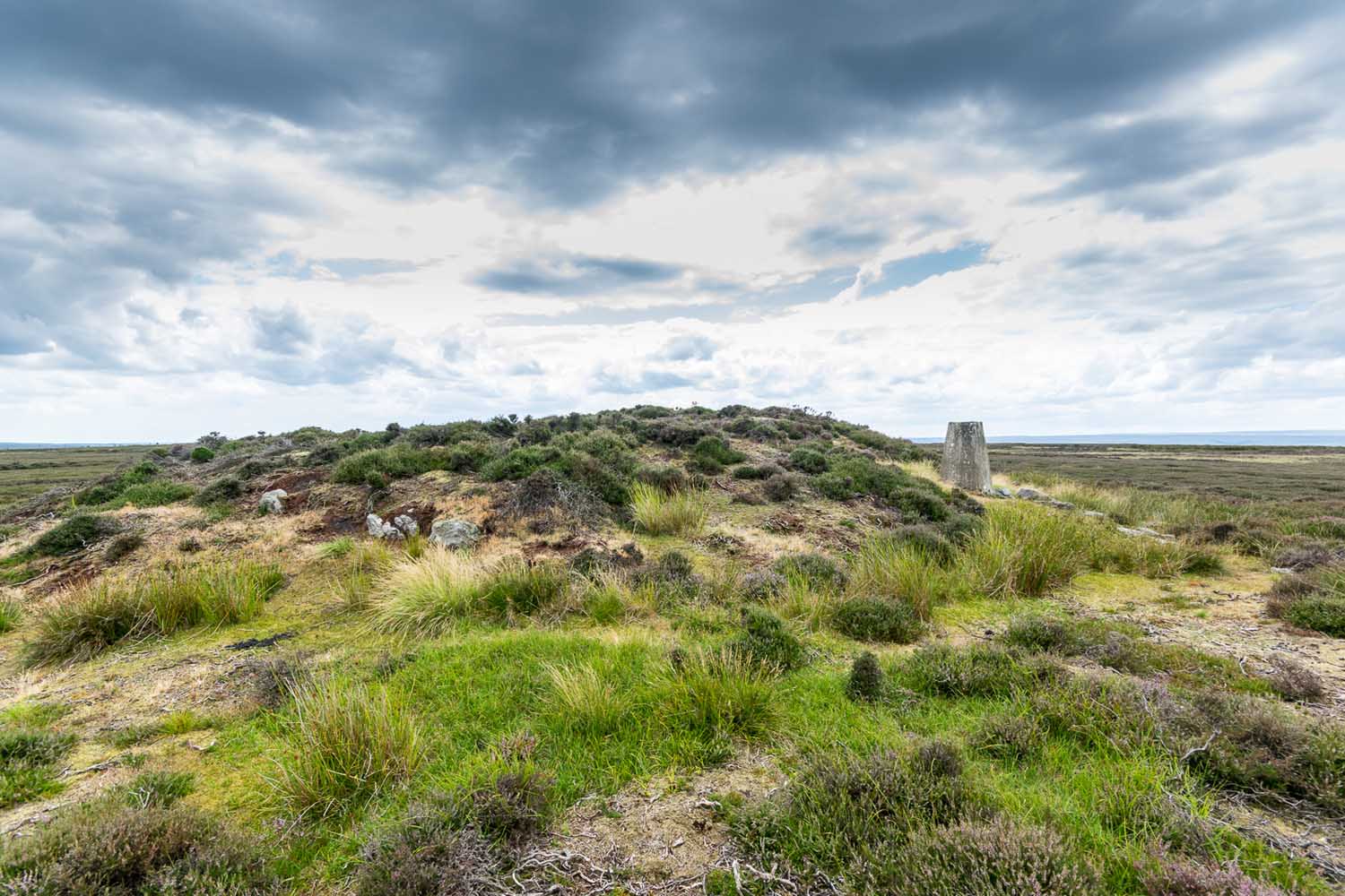
Along the A169 road that runs may miles from Whitby to Pickering, as you go through the small town of Sleights, the road gets steep for a mile or so, until you reach the moorland tops, where the road runs dead straight. After 1.2 miles (1.93km) along the straight road, a small minor road is to your right. Go along here for literally half-a-mile (0.8km) where you’ll see a small dirt-track on your right, with a locked gate. There’s place to park here. You’ll see the large rounded mound of Flat Howe-2 about 200 yards NE. Head there, then another 250 yards north. You’ve arrived!
Archaeology & History
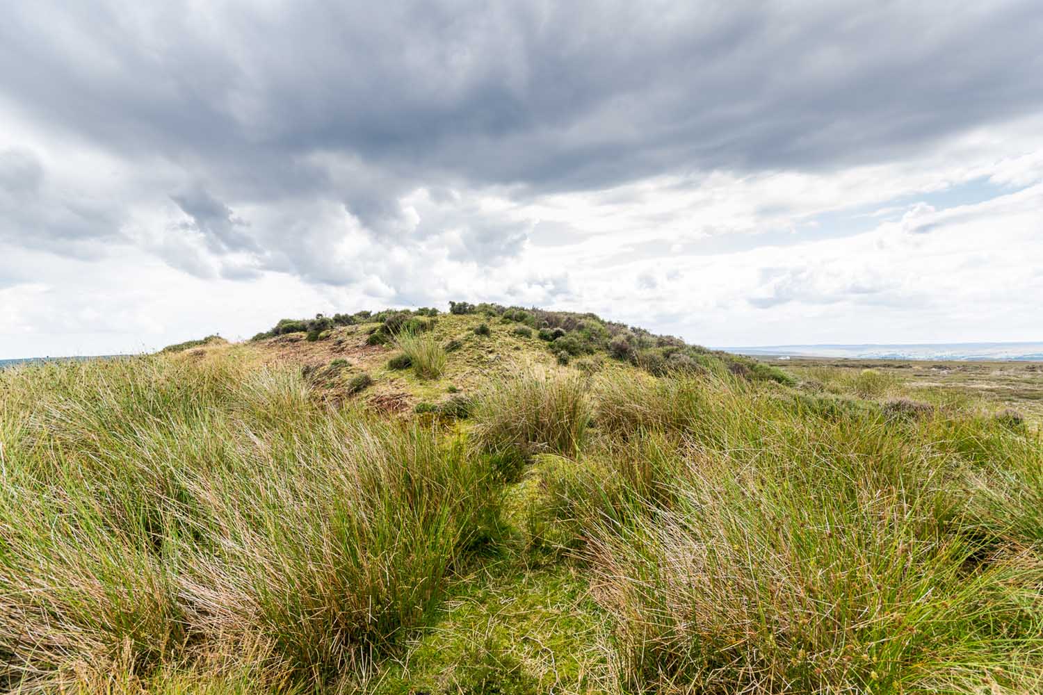
Of the two ‘Flat Howe’ burial mounds on Sleights Moor, this is the northern one of the two, being 250 yards (230m) away from its southern companion (at NZ 85510 04614). It’s quite a big fella too – and so you’d expect there to be quite a bit of information about it. But there isn’t! No recorded excavation has taken place here, despite the top of the monument being cut into. But this might have occurred when the Ordnance Survey lads built one of their triangulation pillars into the side of it. Thankfully it’s not done too much damage.
I was quite surprised to find that even Frank Elgee (1912; 1930) had little to say about either of the two Flat Howes, simply mentioning them in passing in relation to the numerous other prehistoric tombs on these moors. Despite this, the archaeologist L.V. Grinsell (1936) thought this site to be one of “the finest peristalith barrows I have ever seen.” And this one in particular is still very impressive.
Flat Howe from the southFlat Howe (by James Elkington)
First shown on the 1853 OS-map, this large heather-covered mound of earth and stone is some six feet high and measures roughly 22 yards (20m) east-west by 19 yards (17.5m) north-south. The tomb was originally constructed within a circle of reasonably large boulders, some of which were upright. These can still be seen, mainly along the western and southern sides of the monument, although many have been dislodged over time and fallen at various angles, as you can see in the photo. Whether or not these stones were erected first and then the mound built inside the ring, we do not know. It’s the highest point in the landscape on Sleights Moor, with damn good views in all directions: an element that is common to many large prehistoric tombs, for obvious reasons. Other tombs of similar size and probably similar periods in prehistory can be seen close by and on the skyline. Whether this was a deliberate visual ingredient by our tribal ancestors is difficult to say, as the moors here were covered in scattered woodlands in prehistoric times. Only detailed archaeo-botanical surveys would be able to tell us one way or the other.
Folklore
Flat Howe, with large stones defining its edge
Although we have nothing specific relating to this tomb, an olde creation myth told us that the local giants, Wade and his wife Bel, left their young son (whose name seems to have been forgotten) somewhere on Sleights Moor (which aint a big place). It is worth narrating simply because it may have related to this tomb or its companion close by. Giant legends have long been associated with the creation of many prehistoric tombs in this country and abroad. The story was first written down by George Young (1817) in his magnum opus on Whitby and the tale was subsequently re-told by many others – Mrs Gutch (1901) for one:
“Young Wade, even when an infant, could throw a rock several tons weight to a vast distance; for one day when his mother was milking her cow near Swarthoue, the child, whom she had left on Sleights moor, became impatient for the breast, and seizing a stone of vast size, heaved it across the valley in wrath, and hit his mother with such violence, that though she was not materially hurt, her body made an impression on the stone which remained indelible, till the stone itself was broken up, a few years ago, to mend the highways!”
This rock was Bel’s Rock, whose exact location seems to have been lost.
References:
Elgee, Frank, Early Man in Northeast Yorkshire, Frank Bellows: Gloucester 1930.
Elgee, Frank, The Moorlands of North-Eastern Yorkshire, A. Brown: London 1912.
Grinsell, Leslie V., The Ancient Burial Mounds of England, Methuen: London 1936.
Gutch, Mrs, County Folk Lore – volume 2: Examples of Printed Folk-lore Concerning the North Riding of Yorkshire, York and the Ainsty, David Nutt: London 1901.
Jeffrey, P. Shaw, Whitby Lore and Legend, Home: Whitby 1923.
Roberts, Anthony, Sowers of Thunder, Rider: London 1978.
Smith, A.H., The Place-Names of the North Riding of Yorkshire, Cambridge University Press 1928.
Young, George, A History of Whitby and Streoneshalh Abbey – volume 2, Clarke & Medd: Whitby 1817.
Acknowledgements: A huge thanks to Lindsay Mitchell for getting us up to see this great tomb and its companion; and to James Elkington for use of the photograph.
Holy Well (covered): OS Grid Reference – TQ 3157 8111
Archaeology & History
St Brides Well on 1896 map
Close to the centre of that corporate money-laundering place of homo-profanus that is the City of London, was once a site that represents the antithesis of what it has become. Tacked onto the southeastern side of St. Bride’s church along the appropriately-named Bride Lane, the historian Michael Harrison (1971) thought the Holy Well here had Roman origins. It “was almost certainly,” he thought,
“in Roman times, the horrea Braduales, named after the man who probably ordered their construction: Marcus Appius Bradua, Legate of Britain under Hadrian, and the British Governer in whose term of office the total walling of London was, in all likelihood, begun.”
This ‘Roman marketplace of Bradua’ that Harrison describes isn’t the general idea of the place though. Prior to the church being built, in the times of King John and Henry III, the sovereigns of England were lodged at the Bridewell Palace, as it was known. Mentioned in John Stow’s (1720) Survey of London, he told:
“This house of St. Bride’s of later time, being left, and not used by the Kings, fell to ruin… and only a fayre well remained here.”
The palace was eventually usurped by the building of St. Bride’s church. The most detailed account we have of St. Bride’s Well is Alfred Foord’s (1910) magnum opus on London’s water supplies. He told:
“The well was near the church dedicated to St. Bridget (of which Bride is a corruption; a Scottish or Irish saint who flourished in the 6th century), and was one of the holy wells or springs so numerous in London, the waters of which were supposed to possess peculiar virtues if taken at particular times. Whether the Well of St. Bride was so called after the church, or whether, being already there, it gave its name to it, is uncertain, more especially as the date of the erection of the first church of St. Bride is not known and no mention of it has been discovered prior to the year 1222. The position of the ancient well is said to have been identical with that of the pump in a niche in the eastern wall of the churchyard overhanging Bride Lane. William Hone, in his Every-Day Book for 1831, thus relates how the well became exhausted: ‘The last public use of the water of St. Bride’s well drained it so much that the inhabitants of the parish could not get their usual supply. This exhaustion was caused by a sudden demand on the occasion of King George IV being crowned at Westminster in July 1821. Mr Walker, of the hotel No.10 Bridge Street, Blackfriars, engaged a number of men in filling thousands of bottles with the sanctified fluid from the cast-iron pump over St. Bride’s Well, in Bride Lane.” Beyond this there is little else to tell about the well itself, but the spot is hallowed by the poet Milton, who, as his nephew, Edward Philips records, lodged in the churchyard on his return from Italy, about August 1640, “at the house of one Russel a taylor.”
In Mr Sunderland’s (1915) survey, he reported that “the spring had a sweet flavour.”
Sadly the waters here have long since been covered over. A pity… We know how allergic the city-minds of officials in London are to Nature (especially fresh water springs), but it would be good if they could restore this sacred water site and bring it back to life.
Folklore
Bride or Brigit has her origins in early British myth and legend, primarily from Scotland and Ireland. Her saint’s day is February 1, or the heathen Imbolc (also known as Candlemas). Although in christian lore St. Bride was born around 450 AD in Ireland and her father a Prince of Ulster, legend tells that her step-father (more probably a teacher) was a druid and her ‘saintly’ abilities as they were later described are simply attributes from this shamanic pantheon. Legends—christian and otherwise—describe Her as the friend of animals; possessor of a magickal cloak; a magickian and a healer; and whose ‘spirit’ or genius loci became attached to ‘sacred sites’ in the natural world, not the christian renunciation of it. St Bride was one of the primal faces of the great prima Materknown as the Cailleach: the Gaelic deity of Earth’s natural cycles, whose changing seasons would also alter her names, faces and clothes, as Her body moved annually through the rhythms of the year. Bride was (and is) ostensibly an ecological deity, with humans intrinsically a part of such a model, not a part from it, in contrast to the flawed judaeo-christian theology.
References:
Foord, Alfred Stanley, Springs, Streams and Spas of London: History and Association, T. Fisher Unwin: London 1910.
Gregory, Lady, A Book of Saints and Wonders, Colin Smythe: Gerrards Cross 1971.
Harrison, Michael, The London that was Rome, Allen & Unwin: London 1971.
McNeill, F. Marian, The Silver Bough – volume 2, William MacLellan: Glasgow 1959.