Go up the B6160 road, heading for Kilnsey Crag. A few hundred yards past here, take the road to Arncliffe and, several hundred yards along, keep yer eyes peeled for the (usually) decent craggy dry stream bed on your left (west). Follow this upstream till you hit the large cave, continuing uphill above the crags, following the steep walling upwards to the next set of crags. Above these, another long straight line of walling continues in the same direction you’ve been walking. Follow this along until it meets up with another large line of walling, heading NE. Walk along here till this wall changes direction NE, but here you need to walk across the grasses westwards, past the large cave for another 100 yards. You’ll find it!
Archaeology & History
This is a simple but well-preserved circular monument, probably constructed in the Iron Age, just 100 yards past the incredible Douky Bottom cave (in which various prehistoric remains have been found). No excavations appear to have been made here, yet the near-perfect ring is in very good condition indeed. The monument consists of thousands of small stones – taken from the huge scree immediately behind the structure – whose uppermost visible mass overlays a much older and larger pile of stones, all of roughly the same size.
Douky Bottom ring, looking NE
The ring is less than 10 yards across and gives the impression of it being a large hut circle—which it may or may not be. Without an excavation we cannot know its function with any certainty. Other, much larger prehistoric enclosures and settlements are close by, mainly to the northeast; and you have the truly bizarre rock piles on the ghostly horizon crags, whose histories are quiet indeed…. For any antiquarians amongst you who’d like a good day out, give this region a try! It’s a truly intriguing arena with much much more hiding away than any of the archaeology records can tell you about.
Acknowledgements: Many many thanks to James Elkington for guiding us to the sites in this region.
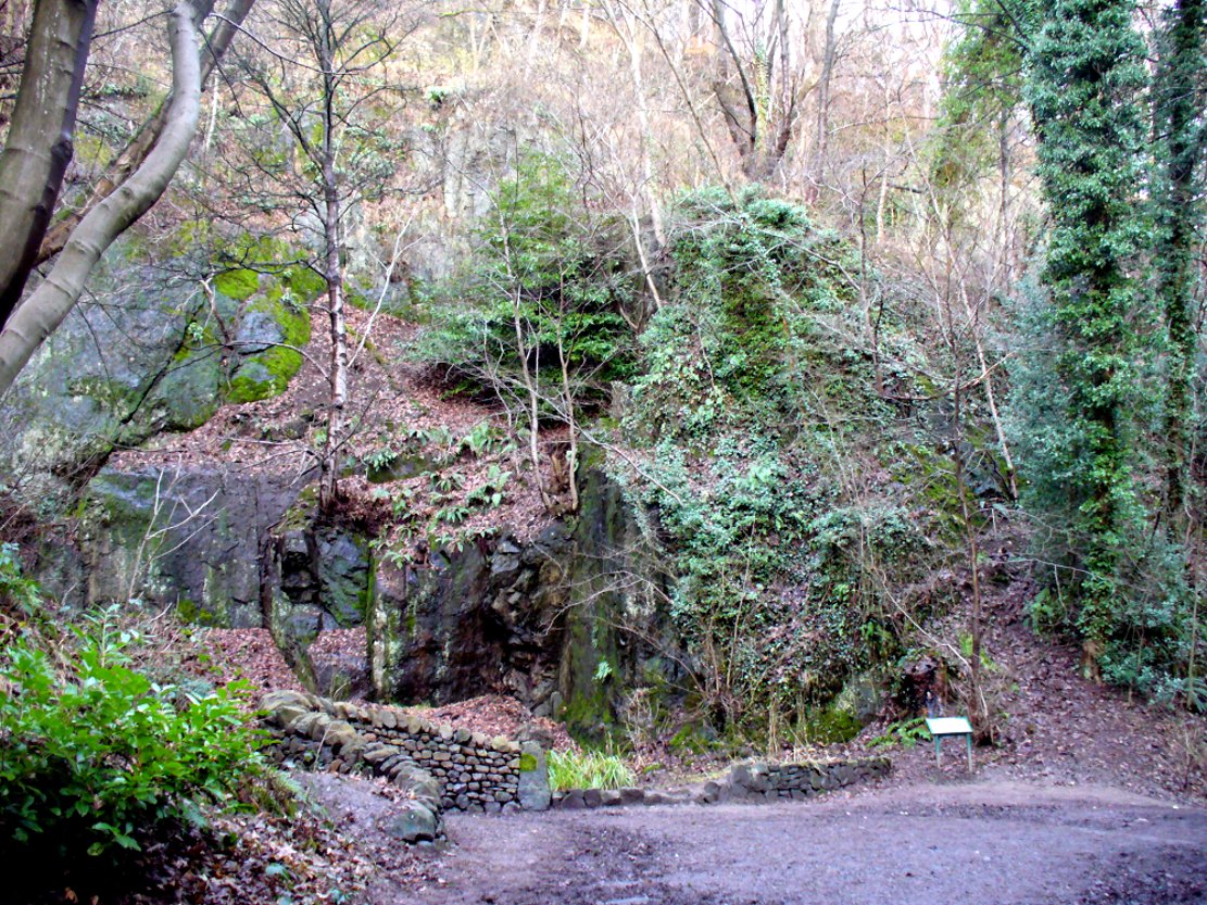
From the main street through Alva, between the Co-op and the corner shop, go up the small road at the side of the Johnstone Arms Hotel (Brook Street) and, at the small crossroads, straight across as if following the sign to the golf course. Stay along the track parallel with the Alva Burn waters and as you go into the trees a hundred yards or so along, to your left is a disused quarry, with a couple of plaques telling you its brief history. This is the spot!
Archaeology & History
This is a truly fascinating site for a number of reasons. Sadly, we can no longer see what had been here for oh so many thousands of years thanks, as usual, to the industrialists destroying the land here. Although in this case, without them we’d be unaware of its very existence. Additionally, there is a twist to the industrial’s find, which seems to have stopped further quarrying by some local people….
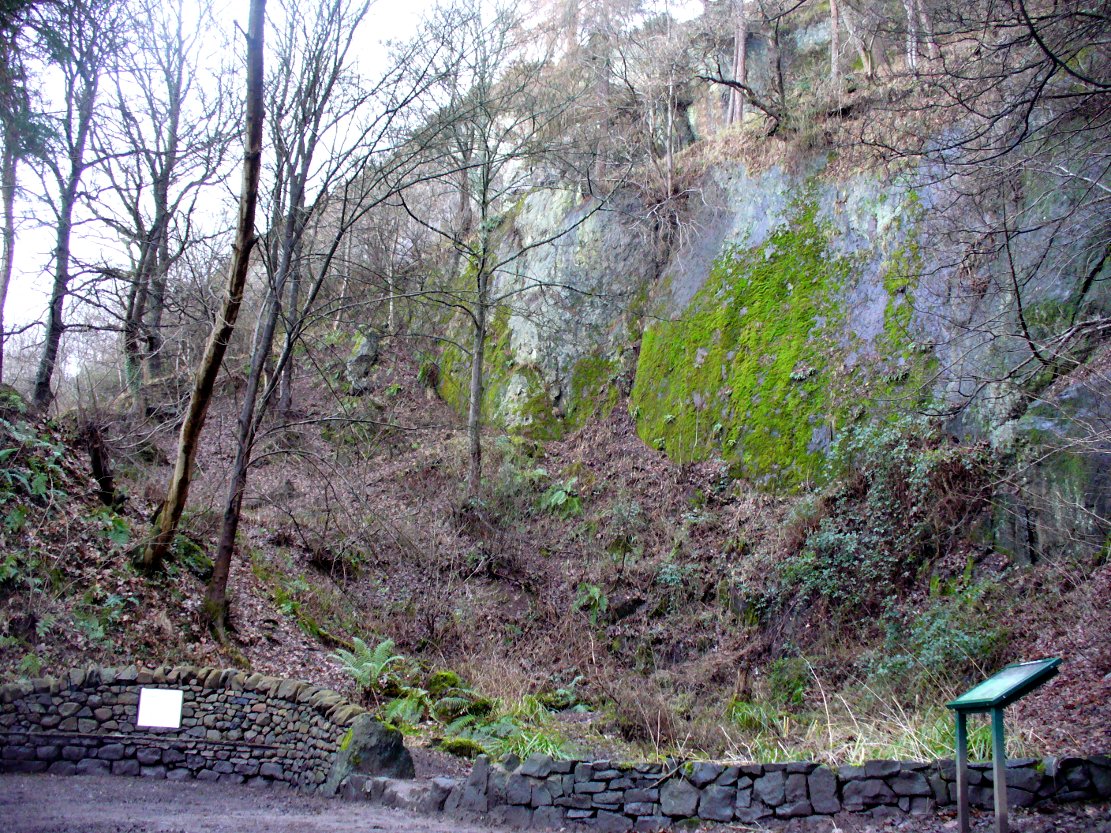
The tomb was somewhere in the left-middle
Listed in the relative Royal Commission accounts (1933; 1978), without comments, the tale is a simple one, but was narrated in some detail by J.G. Callander (1914) in Scotland’s prodigious Society of Antiquaries journal. During some quarrying operations over the Christmas period of 1912, James Murdoch “uncovered the remains of a human skeleton which had been buried in a natural cavity in the rock.” Three weeks later, local police officer George Donald and Dr W.L. Cunningham of Alva, accompanied Mr Callander to the site and made a detailed assessment of what had been found. He wrote:
“The quarry in which the grave was found is situated at the mouth of Alva Glen, a few yards distant from the right bank of the burn which flows through it. The body had been placed in a cavity or rock shelter in the face of the cliff, about 40 feet from the base, and about 200 feet above sea-level, and a rough, curved wall of dry-stone building, about 1 foot in thickness, had been built across the opening, which faced the east, the ends of the wall being still in situ when I visited the site. The space enclosed measured about 4 feet 6 inches from north to south, and about 5 feet from east to west. Subsequent to the burial the whole face of the rock and the walling had been covered, to a thickness of probably some 6 feet, by soil and detritus washed down from the hill face above. The greater part of the floor of the cavity was formed of clean, broken, angular stones, but the space on which the body was placed had been covered with a thin layer of soil preparatory to the burial. No charcoal or charred wood, which is so often seen in prehistoric graves, was found in this deposit. The skull lay in the north end of the grave, on its right side, facing the rock to the west, the vertebrae and ribs followed a line to the south, and the nether limbs were inclined towards the interior of the cavity. The whole face, including all the teeth and the lower jaw, was a-wanting. Apparently the body had been placed in a flexed position, half on its side and half on its back. Nothing else was found in the grave but a quantity of snail shells, probably twenty or thirty, which were nearly all broken, the few complete examples being in a very fragile condition.
“Elsewhere it has been stated that these formed a necklace, but while they were strewn out in front of the skeleton for a distance of over 3 feet, none of them showed any signs of artificial perforation. The species of Helixis is probably hortensis, the common garden snail.”
Mr Callander then included a lengthy description of the body itself, some of whose bones were fractured. He told that a certain
“Professor Bryce states that the skeleton is that of a dwarf of about 4 feet 2 inches in stature. The epiphyses are all fully united, although the line of union is visible on the surface at some points. Growth must therefore have been completed, and the person must have been, if the union of the epiphyses of the long bones had pursued its normal course, over twenty-one years of age…”
Regarding the sex of the dwarf, Mr Bryce wasn’t 100% certain, but told:
“The calvaria shows the general characters of a female skull, but it cannot be stated definitely that the individual was a woman, because the cranial characters are such as might have been present in a dwarf of the male sex. The calvaria is of moderate size, and is well formed.”
Bryce concluded as a whole that this person was in reasonably good health and, from the condition of the bones, showed “there was no evidence of the disease known as rickets.” In his final remarks he told:
“The general conclusions to which a careful examination of the skeleton leads, is that we have here to do, not with a representative of a dwarfish race, but with an individual who from premature union of the epiphyses was to a remarkable degree stunted in growth. The condition is a well-known one, and the class of dwarfs, in which this individual must be included, is well recognised.”
Probable spot of the lost tomb
The exact spot of the tomb appears to have been destroyed, or at the very least is certainly covered over and no longer visible. The section of the quarry looking east, into which the tomb was built, is all-but gone and no initial evidence prevails to show its exact location. However, it would seem from the description to have been close to the tops of the tree-line, perhaps giving a clear view to the rising sun in the east. Perhaps…
The position of this tomb, enclosed high up in the cliffs, hidden away at the entrance to the deeply cut ravine of the Alva Glen, is intriguing in that it is a rarity. Ravines like this are always peopled by olde spirits in animistic tribal traditions — and this dangerous glen with its fast waters and high falls would have been no different, especially to the Pictish people who we know were still here even after the Romans had buggered off. Is it possible that this figure was a guardian to the Glen itself, a medicine woman or shaman, whose very Glen was her home? We know from traditional accounts in many of the North American tribes that dwarves were accessories to the spirit worlds, and some were shamans. (Park 1938) In northern and central European lore, these small people are “the mysterious craftsmen-priests of early civilizations.” (Motz 1987) Whilst in Scottish lowland lore, the ‘Brown Man of the Muirs’ was a dwarfish creature described by Briggs (1979) as “a guardian spirit of wild beasts”, or watered-down shaman figure. There is more to this burial than meets the eye of dry academia…
Folklore
The Alva Glen—in addition to being beautiful and home to the Ladies Well—was long known to be one of many places in the Ochils that were peopled by the faerie folk. (Fergusson 1912) Local people still say this place is haunted by the spirit of a dangerous witch called Jenny Mutton.
It’s worth reiterating the words of Mr Callander (1914) regarding the finding and subsequent death of the man who uncovered this fascinating tomb, as some folk (then as now) think his demise was as inevitable as the man who planned on building turbines in Glen Cailleach:
“On the 24th December last, while quarrying stone for road metal in a quarry at the foot of the Ochils, at Alva, James Murdoch uncovered the remains of a human skeleton which had been buried in a natural cavity in the rock. Two days later he was killed at the same spot by the fall of a mass of overhanging rock, a tragic sequel, which not long ago would have been considered a judgement on him for disturbing the dead.”
References:
Briggs, Katherine M., A Dictionary of Fairies, Penguin: Harmondsworth 1979.
Corbett, L., et al., The Ochil Hills, Forth Naturalist & Historian 1994.
Drummond, A.L., “The Prehistory and Prehistoric Remains of the Hillfoots and Neighbouring District”, in Transactions Stirling Natural History & Antiquarian Society, volume 59, 1937.
Fergusson, R. Menzies, The Ochil Fairy Tales, David Nutt: London 1912.
Gimbutas, Marija, “Slavic Religion,” in Encyclopedia of Religion – volume 13 (editor M. Eliade), MacMillan: New York 1987.
Motz, Lotte, “Dvergar,” in Encyclopedia of Religion – volume 4 (editor M. Eliade), MacMillan: New York 1987.
Park, Willard Z., Shamanism in Western North America: A Study in Cultural Relationships, Evanston: Chicago 1938.
Royal Commission on the Ancient & Historical Monuments, Scotland, Inventory of Monuments and Constructions in the Counties of Fife, Kinross and Clackmannan, HMSO: Edinburgh 1933.
Royal Commission on the Ancient & Historical Monuments, Scotland, The Archaeological Sites and Monuments of Clackmannan District and Falkirk District, Society of Antiquaries of Scotland 1978.
John Dixon took a bunch of us on a pleasant amble here via the Fair Oak Circle site. From Fair Oak, go round the back of the farm and past the small cluster of hidden cottages, then bear right down the dirt-track and up the slope, then cross the field in front of you, going over the stile, following the footpath round the eastern edge of the slightly limestone New Laund Hill, and down again, thru the gate. From here, head diagonally across the field 150 yards towards the fencing at the woodland edge. Over the fence, into the trees, head halfway down the steep-ish slope and keep your eyes peeled for the rocky outcrop nearly halfway down. Alternatively, an easier way here is apparently from the Inn at Whitewell. Go across the river via the stepping stones (or wade!) and follow the footpath uphill towards a farm, where you’ll find a large steel gate on the left that leads into the woods. Here there are 2 paths: follow the higher of the two until it starts bearing to the right. Once here, look up the hill to the right you’ll see the rock outcrop. The caves are there!
Archaeology & History
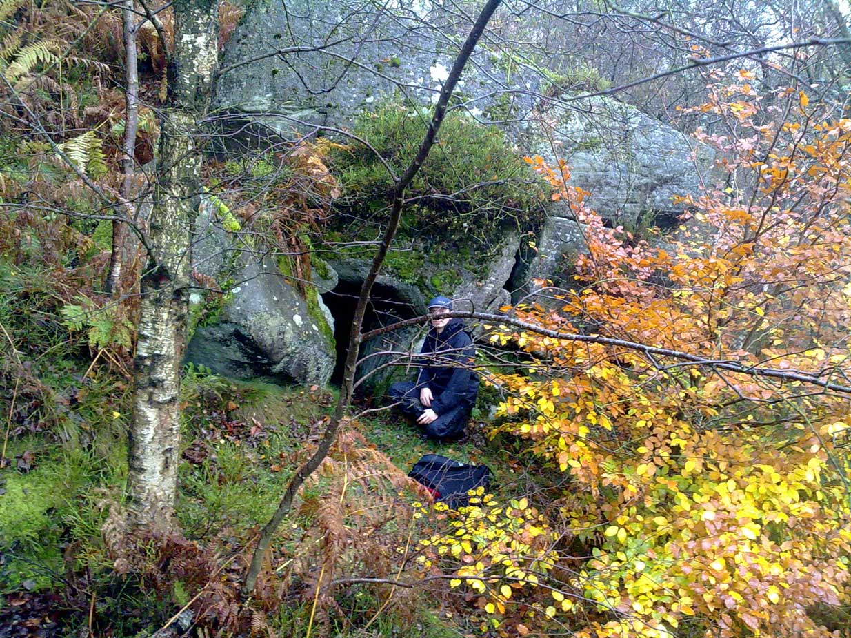
Smaller Fairy Hole
There are at least 3 caves here, close to each other along the edge of the small footpath a few yards apart. The small rounded entrance of the northernmost one (photo, right) is reported by English Heritage to have had no human remains found therein, but further investigation is required here. The main cave however is where intriguing prehistoric finds were located. It appears that the entrance was deliberately built-up and blocked by stone walling a few yards inwards, giving the remains found therein a state of protection and sanctity. Writer and historian John Dixon (2004) tells what was in the cave:
“In 1946, an excavation was carried out on the site by the archaeologist Reginald C. Musson. In front of the larger cave is a flat platform on which evidence of Bronze Age daily life was found. This included animal bones, a pebble pounder (used to extract marrow from bones) and shards of a food vessel.
“All that survived of this tripartite collared urn was a large rim-collar shard, two fragments displaying neck/shoulder/body elements and five smaller pieces, probably from the base of the body. This is the only collared urn to have been found in a cave in Lancashire. Its tripartite Pennine form assigns it to an early Bronze Age date.”
The main Fairy HolePlan of cave chamber (after J.Dixon 2004)
The artificial walled entrance may not merely have been an ingredient giving sanctity to the place, but this could well have been a site for ritual shamanic practices, including prolonged rites of passage and death rituals (authentic ones, not the modern pagan nonsense). The ‘ritual death’ elements are highly probable here for, as John Michell (1975) told, caverns and crevasses are “most responsive to the necromancer’s invocation”. It’s geomancy, spirit association and the archaeological finds therein are strongly suggestive of this usage. (Eliade 1989, 1995; Maringer 1960, etc) Bearing this in mind, it is of some concern regarding the individual who thought it wise to spray-paint his name against the wall of the cave entrance (see photo); for many are those even in these days of shallow minds who fall prey to the car-crashes and creeping madness brought upon themselves by desecrating ancestral sites of ritual magick. It would be intriguing to keep a prolonged eye on the ‘Forsh’ who painted his ego in this cave of dead spirits…
Folklore
Not surprisingly, the little people hold legend here. Jessica Lofthouse (1946) found tales of these ancient peoples in several places close by, but at the Fairy Caves specifically,
“everyone knew that these little caves in the limestone at Whitewell were the homes of the little folk.”
…And in relation to the ingredient mentioned above, about ritual use of the cave in ancient times: are there any serious ritual magickians who’ve spent time working in this cave, overnight or longer, and who can let us know of their encounters here? (long shot, I know – but it’s worth asking, considering the probable use of the place) Or perhaps spontaneous encounters of other people here…
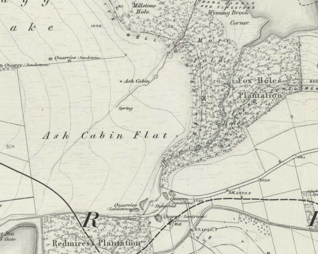
Park at Wyming Brook nature reserve car park off Redmires road and head off up the steps to the right of the notice board. Turn immediately right through the trees and you’ll soon pick up the path running along the ridge above Wyming Brook drive. Stay on the obvious path for around ½-mile passing “Big rock” to your right and the views it offers over Rivelin Valley and the dams. A short way further along the path steps down a couple of feet and turns to the right before straightening again, this is where you need to start looking down the edge to your right for a large rock that resembles a Chesterfield sofa which makes up part of the shelters roof.
Once you’ve located the site a short scramble will be needed to gain access to the entrance and this is where care is needed. It’s not difficult but has the potential to be deadly due to the steep nature of the edge so please take care and keep any kids on a very short rein.
Head down to the right of the “sofa” and jump down the 3ft drop holding onto the rather handy bracken and saplings if needed and the entrance is right there to your left.
Archaeology & History
Errr……..yeah, it’s history! — Well I’ve yet to find anyone else that actually knows about this cave, let alone it’s past! There are obviously locals who know of it’s existence but after half a dozen visits there I’ve not seen anyone except a brave old lady, 70 if-a-day, who was there looking for the supposed wartime carvings and that was on my first visit.
I have tried every possible avenue i know to reveal the caves past but as yet nothing, I’d be grateful if you could enlighten me at all.
I did e-mail John Barnatt with hope he’d have some information but alas no, though it is admittedly just outside his patch being on the Sheffield side of the Derbyshire / Sheffield border.
The shelters entrance is around 3ft high but once inside the roof quickly gains height and tops out at around 7ft so standing is easy. Beware half way along the interior by the small opening though — you’ll crack your head if your attention is drawn to the light beaming in through the side! There’s quite a bit of occupation rubbish within the cave due to someone making their home there: a sleeping bag, old tin cans, bottles, etc, is evidence enough, but the stuff’s quite old and no one resides their now.
“X” marks the spot!
At the far end of the shelter is a small chimney like opening and it’s just possible to squeeze between the fallen rocks and make your way out, it would also make an excellent outlet for smoke if you chose to have a warming fire inside.
You probably won’t notice on your way in but coming out and on the rocks by the entrance to your left are carvings dated to 1944 said to have been inscribed by German prisoners of war held in the area but I’ve yet to substantiate that.
From Durness take the road east for a couple of miles till you see the signpost which takes you on the left-hand side of the road, down to the coast. You can’t miss it!
Archaeology & History
Findings here allege to take the history of the place into the mesolithic period, but we don’t know this for sure. An excavation here by a Mr Donald Macdonald of Sangobeg in 1904 uncovered the presence of several small bone pins, which seem consistent with Mesolithic finds elsewhere. When archaeo-excavations were done here in 1982, human remains going back to at least Iron Age were found in the simple deposit of many shells. A further analysis by the Glasgow Archaeology Unit in 1996 was prevented of some excavation by (get this!) those screwy Health & Safety regulations. Here’s a definite case for an independent group to undertake work here, as we could ignore such preventative measures (and if we drown it’s our fault!). Smoo Cave’s primary function is pretty obvious: it would have been used for both shelter and ritual.
Folklore
The folklore here tells of magick and occultism and possible remnants of rites of passage lore. For herein, many centuries ago, a powerful land-owner called Lord Reay — reputed as a master in the black arts — battled with the devil in the Smoo Cave.
The devil was keeping watch on Lord Reay following a previous dispute between the two of them, and espied him as he entered the cave. As Alexander Polson told it, the cave
“consists of three caverns, one within the other. Lord Reay had got as far as the second, and his dog, which had gone on in advance, returned howling and hairless. By this, Lord Reay knew that Satan was there before him, and bravely waited the attack, which was soon made, and his lordship fought lustily. Happily at the opportune moment a cock crew. This frightened the devil and his attendant witches, but Lord Reay stood between them and the exit. In their fright they blew holes through the roof of the cave, and this is the origin of the two openings through which the Smoo burns fall.”
Pitch black cave; protective spirit animal; encountering one’s psychological nemesis; unconscious battles with Underworld forces; rebirth of the sun at cock-crowing time; the conquering of the dark forces and renewal of Lord Reay. These are typical hallmarks probably signifying folk-remnants of shamanism and rites of passage, for which this cave may once have been used.
References:
Polson, Alexander, Scottish Witchcraft Lore, W. Alexander: Inverness 1932.