This long lost ‘holy well of St Brigit’ (Tobar Bhride) has been mentioned—purely in literary repetition—by such folklore giants as F.M. MacNeill and others, but none of them give any additional information about it than that first mentioned by Alexander Stewart’s (1890) in his fascinating article on magical stones. Indeed, knowledge of this well’s very existence was only preserved thanks to a ritual incantation that was recited to imbue and maintain healing properties of one such magickal stone, known as the Charm Stone of Keppoch. It
“was an oval of rock crystal, about the size of a small egg, fixed in a bird’s claw of silver, and with a silver chain attached, by which it was suspended when about to be dipped.”
It was dipped in water taken from the sacred well of St Brigit, somewhere not far from Keppoch. The incantation made over the stone was in Gaelic, obviously, but the english translation is:
“Let me dip thee in the water,
Thou yellow, beautiful gem of Power!
In water of purest wave,
Which (saint) Bridget didn’t permit to be contaminated.
In the name of the Apostles twelve,
In the name of Mary, virgin of virtues,
And in the name of the high trinity
And all the shining angels,
A blessing on the gem,
A blessing on the water, and
A healing of bodily ailments to each suffering creature.”
On the east side of the river, just a few hundred yards away, could once be found the Fuaran na Ban-Tighearna, or the Well of Her Ladyship. In this sense, the term ‘ladyship’ refers to the “wife of a baronet or knight.” (Dwelly 1918) The idea that it may refer to Bride in Her guise as a ‘lady’ is linguistically improbable here (though not impossible). Also, if this fuaran did have a geomythic relationship with Bride, we would expect to find a Cailleach in the nearby landscape, which we don’t.
Folklore
An interesting piece of folklore that may relate to this well is described by the great Scottish landscape wanderer, Seton Gordon. (1948) Although he makes no mention of a Bride’s Well, there is the tale of a missing bride up Glen Roy, of which Keppoch sits below. “It was in earlier times,” he wrote,
“that the Maid of Keppoch was taken by the fairies in Glen Roy. She was an Irish girl, little more than a child, and had become the wife of MacDonell of Keppoch. But the wedding rejoicings were scarcely over when the bride, wandering into the oak woods which still clothe the lower slopes of Glen Roy, disappeared mysteriously. It was believed that, like the Rev Robert Kirk…she had been spirited away by the fairies. If indeed she was abducted by the Little People they held her closely, for from that day to this no trace has been found of the fair Maid of Keppoch.”
St Bride of course was Irish, like the Maid of Keppoch. And just a mile up Glen Roy from Keppoch House we find the Sron Dubh and Sithean, or Ridge of the Dark Fairy Folk. There are several burns (streams) running either side and below this fairy haunt, but I can find none with Bride’s name. Someone, somewhere, must know where it is…
References:
Gordon, Seton, Highways and Byways in the Central Highlands, MacMillan: London 1948.
Dwelly, Edward, The Illustrated Gaelic English Dictionary – volume 1, Fleet Hants 1918.
Stewart, Alexander, “Notice of a Highland Charm-Stone,” in Proceedings Society Antiquaries, Scotland, volume 24, 1890.
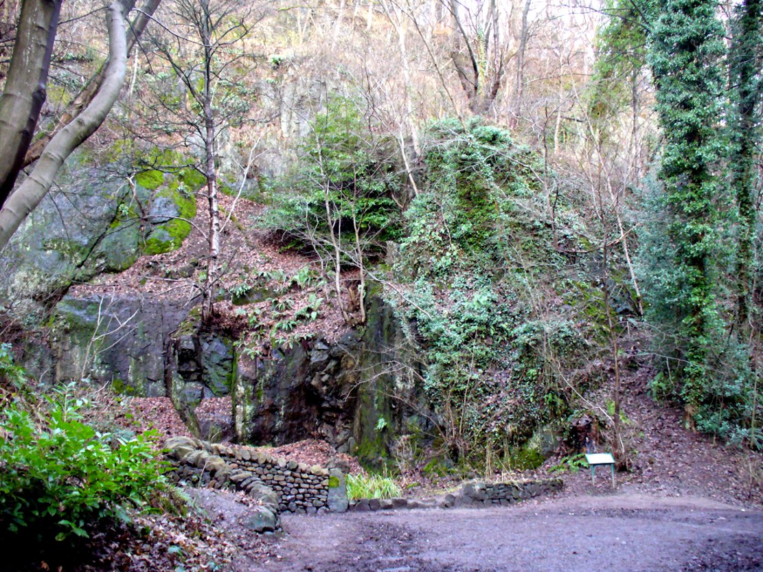
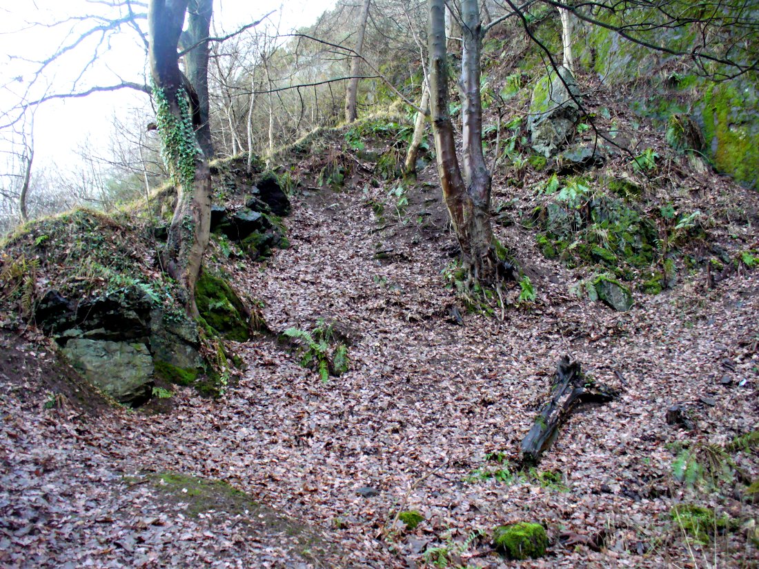
From the main street through Alva, between the Co-op and the corner shop, go up the small road at the side of the Johnstone Arms Hotel (Brook Street) and, at the small crossroads, straight across as if following the sign to the golf course. Stay along the track parallel with the Alva Burn waters and as you go into the trees a hundred yards or so along, to your left is a disused quarry, with a couple of plaques telling you its brief history. This is the spot!
Archaeology & History
This is a truly fascinating site for a number of reasons. Sadly, we can no longer see what had been here for oh so many thousands of years thanks, as usual, to the industrialists destroying the land here. Although in this case, without them we’d be unaware of its very existence. Additionally, there is a twist to the industrial’s find, which seems to have stopped further quarrying by some local people….
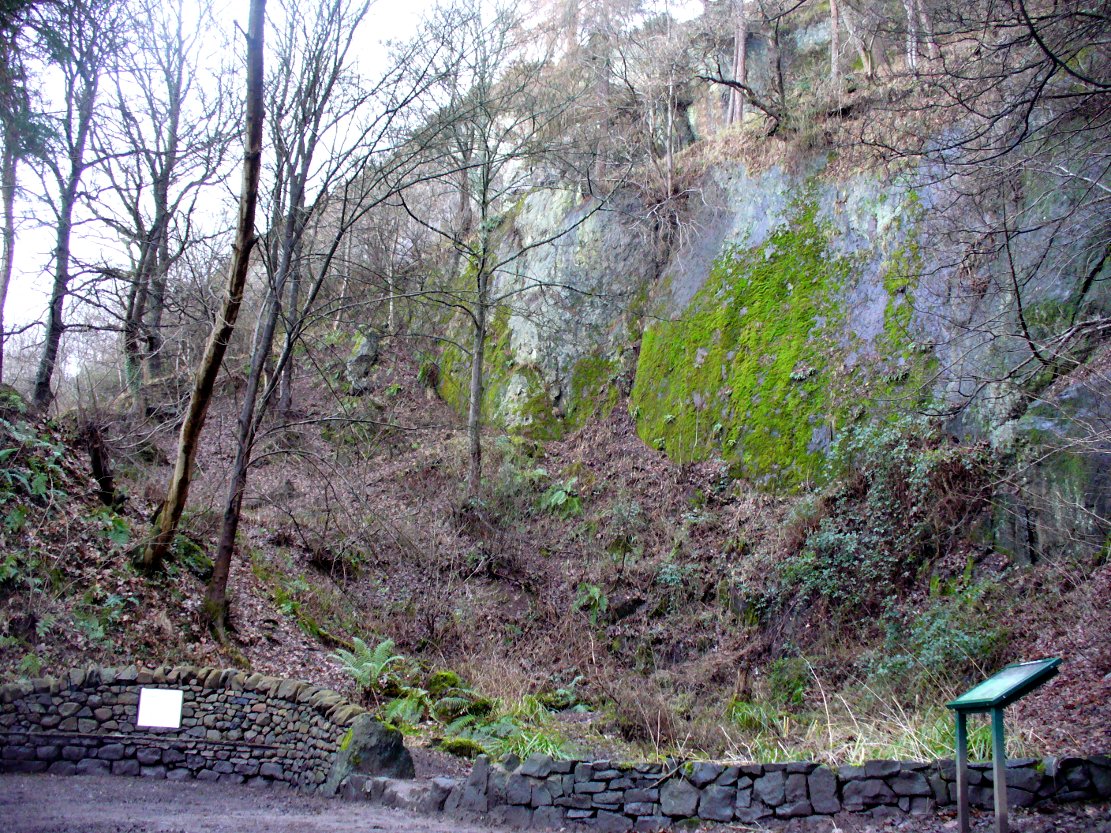
The tomb was somewhere in the left-middle
Listed in the relative Royal Commission accounts (1933; 1978), without comments, the tale is a simple one, but was narrated in some detail by J.G. Callander (1914) in Scotland’s prodigious Society of Antiquaries journal. During some quarrying operations over the Christmas period of 1912, James Murdoch “uncovered the remains of a human skeleton which had been buried in a natural cavity in the rock.” Three weeks later, local police officer George Donald and Dr W.L. Cunningham of Alva, accompanied Mr Callander to the site and made a detailed assessment of what had been found. He wrote:
“The quarry in which the grave was found is situated at the mouth of Alva Glen, a few yards distant from the right bank of the burn which flows through it. The body had been placed in a cavity or rock shelter in the face of the cliff, about 40 feet from the base, and about 200 feet above sea-level, and a rough, curved wall of dry-stone building, about 1 foot in thickness, had been built across the opening, which faced the east, the ends of the wall being still in situ when I visited the site. The space enclosed measured about 4 feet 6 inches from north to south, and about 5 feet from east to west. Subsequent to the burial the whole face of the rock and the walling had been covered, to a thickness of probably some 6 feet, by soil and detritus washed down from the hill face above. The greater part of the floor of the cavity was formed of clean, broken, angular stones, but the space on which the body was placed had been covered with a thin layer of soil preparatory to the burial. No charcoal or charred wood, which is so often seen in prehistoric graves, was found in this deposit. The skull lay in the north end of the grave, on its right side, facing the rock to the west, the vertebrae and ribs followed a line to the south, and the nether limbs were inclined towards the interior of the cavity. The whole face, including all the teeth and the lower jaw, was a-wanting. Apparently the body had been placed in a flexed position, half on its side and half on its back. Nothing else was found in the grave but a quantity of snail shells, probably twenty or thirty, which were nearly all broken, the few complete examples being in a very fragile condition.
“Elsewhere it has been stated that these formed a necklace, but while they were strewn out in front of the skeleton for a distance of over 3 feet, none of them showed any signs of artificial perforation. The species of Helixis is probably hortensis, the common garden snail.”
Mr Callander then included a lengthy description of the body itself, some of whose bones were fractured. He told that a certain
“Professor Bryce states that the skeleton is that of a dwarf of about 4 feet 2 inches in stature. The epiphyses are all fully united, although the line of union is visible on the surface at some points. Growth must therefore have been completed, and the person must have been, if the union of the epiphyses of the long bones had pursued its normal course, over twenty-one years of age…”
Regarding the sex of the dwarf, Mr Bryce wasn’t 100% certain, but told:
“The calvaria shows the general characters of a female skull, but it cannot be stated definitely that the individual was a woman, because the cranial characters are such as might have been present in a dwarf of the male sex. The calvaria is of moderate size, and is well formed.”
Bryce concluded as a whole that this person was in reasonably good health and, from the condition of the bones, showed “there was no evidence of the disease known as rickets.” In his final remarks he told:
“The general conclusions to which a careful examination of the skeleton leads, is that we have here to do, not with a representative of a dwarfish race, but with an individual who from premature union of the epiphyses was to a remarkable degree stunted in growth. The condition is a well-known one, and the class of dwarfs, in which this individual must be included, is well recognised.”
Probable spot of the lost tomb
The exact spot of the tomb appears to have been destroyed, or at the very least is certainly covered over and no longer visible. The section of the quarry looking east, into which the tomb was built, is all-but gone and no initial evidence prevails to show its exact location. However, it would seem from the description to have been close to the tops of the tree-line, perhaps giving a clear view to the rising sun in the east. Perhaps…
The position of this tomb, enclosed high up in the cliffs, hidden away at the entrance to the deeply cut ravine of the Alva Glen, is intriguing in that it is a rarity. Ravines like this are always peopled by olde spirits in animistic tribal traditions — and this dangerous glen with its fast waters and high falls would have been no different, especially to the Pictish people who we know were still here even after the Romans had buggered off. Is it possible that this figure was a guardian to the Glen itself, a medicine woman or shaman, whose very Glen was her home? We know from traditional accounts in many of the North American tribes that dwarves were accessories to the spirit worlds, and some were shamans. (Park 1938) In northern and central European lore, these small people are “the mysterious craftsmen-priests of early civilizations.” (Motz 1987) Whilst in Scottish lowland lore, the ‘Brown Man of the Muirs’ was a dwarfish creature described by Briggs (1979) as “a guardian spirit of wild beasts”, or watered-down shaman figure. There is more to this burial than meets the eye of dry academia…
Folklore
The Alva Glen—in addition to being beautiful and home to the Ladies Well—was long known to be one of many places in the Ochils that were peopled by the faerie folk. (Fergusson 1912) Local people still say this place is haunted by the spirit of a dangerous witch called Jenny Mutton.
It’s worth reiterating the words of Mr Callander (1914) regarding the finding and subsequent death of the man who uncovered this fascinating tomb, as some folk (then as now) think his demise was as inevitable as the man who planned on building turbines in Glen Cailleach:
“On the 24th December last, while quarrying stone for road metal in a quarry at the foot of the Ochils, at Alva, James Murdoch uncovered the remains of a human skeleton which had been buried in a natural cavity in the rock. Two days later he was killed at the same spot by the fall of a mass of overhanging rock, a tragic sequel, which not long ago would have been considered a judgement on him for disturbing the dead.”
References:
Briggs, Katherine M., A Dictionary of Fairies, Penguin: Harmondsworth 1979.
Corbett, L., et al., The Ochil Hills, Forth Naturalist & Historian 1994.
Drummond, A.L., “The Prehistory and Prehistoric Remains of the Hillfoots and Neighbouring District”, in Transactions Stirling Natural History & Antiquarian Society, volume 59, 1937.
Fergusson, R. Menzies, The Ochil Fairy Tales, David Nutt: London 1912.
Gimbutas, Marija, “Slavic Religion,” in Encyclopedia of Religion – volume 13 (editor M. Eliade), MacMillan: New York 1987.
Motz, Lotte, “Dvergar,” in Encyclopedia of Religion – volume 4 (editor M. Eliade), MacMillan: New York 1987.
Park, Willard Z., Shamanism in Western North America: A Study in Cultural Relationships, Evanston: Chicago 1938.
Royal Commission on the Ancient & Historical Monuments, Scotland, Inventory of Monuments and Constructions in the Counties of Fife, Kinross and Clackmannan, HMSO: Edinburgh 1933.
Royal Commission on the Ancient & Historical Monuments, Scotland, The Archaeological Sites and Monuments of Clackmannan District and Falkirk District, Society of Antiquaries of Scotland 1978.
Legendary Rocks (destroyed): OS Grid Reference – NO 3813 5496
Archaeology & History
Like many rocking stones across the British Isles that were written about by early 18th and 19th century authors, the ones at Kirriemuir have fallen prey to the vandalism of those people (christians, Industrialists and other self-righteous fools) that has so blighted our heritage, and ancestral history, with an intolerance of indigenous beliefs and remarkable geological formations. But, I suppose, at least we have a record of them, which at least in some way gives us the ability to add further our knowledge of the traditional practices of our peasant ancestors and their perception of the landscape.
Rocking stones shown on 1865 6-inch OS-mapRocking stones shown on 1865 25-inch OS-map
The exact location of the legendary rocks were highlighted on early Ordnance Survey maps, thankfully; and there were in fact two rocking stones here, very close to each other by the sound of it. Mentioned only in passing by E.S. Valentine (1912), the place was best described in A.J. Warden’s (1884) massive history work on the region. He told that:
“On the top of the Hillhead, Kirriemuir, there were two fine specimens of these interesting memorials, upon which the dwellers in the district looked with wonder and awe. These time honoured monuments of a long past age were, in 1843, blasted with gunpowder, and the shattered pieces used in building dykes and forming drains, to the deep regret of antiquarians, and of the inhabitants of the district. …These stone memorials of a remote age are thus described by the Rev., T. Easton, D.D., in the new Statistical Account of the parish — ‘The one of them is a block of whinstone, nearly oval, and is three feet three inches in height, and four feet ten inches in breadth. The other, of Lintrathen porphyry, is two feet in height, eight feet in length, and five feet in breadth.’ He gives no description of the bases upon which the magic pivots moved, or other details of them.”
About a half-mile east you would have looked across at the large standing stone on Kirriemuir Hill, which legend asserts was once a stone circle (it too, destroyed). If anyone has any further information about these old stones, please let us know…
References:
Valentine, E.S., Forfarshire, Cambridge University Press 1912.
Warden, Alex J., Angus or Forfarshire: The Land and People – Descriptive and Historical – volumes 1 & 4, Charles Alexander: Dundee 1880-1884.
From Clackmannan Main Street, go down the Cattle Market and straight across at the junction, downhill. Keep going on the country lane for half-a-mile watching out for Grassmainston Farm on the left. Go past here and up the next dirt-track for a few hundred yards, watching out for a copse of trees on your left a coupla hundred yards away. Go to the very top corner of the copse, following the stream to its source. That’s it!
Archaeology & History
In a truly fascinating historical case of witchcraft (there was a lot of it in this area according to court and church records), heard in Clackmannan on 16th July, 1700, a certain spring of water, or well, was described, where acts of healing and sympathetic magick were performed and, it would seem, was quite well known to the people cited in the case. It seems very likely from reading the account, that the well in question had magical repute locally. The well was not named, but thankfully the information in the case has allowed us to identify the place in question. When I came here a month or two ago, the well was very overgrown (hence the poor photo above), so I’m gonna go back for another look at the place when Winter’s brushed back the vegetation.
The tale surrounding the well was included in Simpkin’s (1914) Folklore Society survey of Fife and Clackmannan a hundred years ago, and is as follows:
“John Scobie, younger, in Clackmannan, was called, who being of age thirty-eight, was sworn and interrogated if he went up with his uncle to a south-running well at Grassmainston. Deponed that he did go up with him, alone, the first night, and as his uncle was casting off his clothes at the well, the deponent saw a black man …coming from Kersemill; and when he came to the head of Robert Stupart’s folds there was a great squealing among the cattle. Also, when deponent had his uncle down to sprinkle him, he saw a brindled cat come out from among the corn within a little distance from him. He put magic powders upon his uncle when he was naked, which he had received from his said uncle’s wife, Margaret Bruce, who remarked to the deponent that the woman who directed (them), “would get a flee before he came back”; and that, at his return, at Goldney, he heard a terrible noise as of coaches, and that he was dripping of sweat when he came into the house.
“The said Margaret had forbidden them to speak in going or coming, which injunction they observed. When they came to call the deponent to go the second night he refused, till the deceased Robert Reid came and took him, and they both went with him, and saw the black man and the cat, and heard the cattle squeal as aforesaid and, when they were coming back again, there came a great wind upon the trees on the side of the Devon and, when he was crossing the Cartechy Burn his uncle’s foot slipped and he fell in the burn. Thereupon Robert Reid said, “The cure is lost. There is no helping of you now!” And so they spoke from thenceforth until they came home; for Margaret Bruce, the said James Scobie’s wife, told them that if he fell into the water he would not be cured. The witness further added that when they told Margaret that her husband had fallen into the water, she wept. ”
The magickal well in this case would appear to be one identified at the very top of the small copse of trees immediately north of Grassmainston farmhouse, just 3-400 hundred yards away up the slope. It is a “south-running well” as cited in the case and no other water source is immediately apparent. It would be good if any students or antiquarians living near Alloa could check local library records and see if there’s any further information about this site. A short distance north of here is the curiously-named ‘Serpent Wood’, with its old well, fallen stone and lost legends…
…to be continued…
References:
Simpkins, John Ewart, County Folklore – volume VII: Examples of Printed Folk-Lore Concerning Fife, with some Notes on Clackmannan and Kinross-Shires, Folk-Lore Society: London 1914.
Follow the same directions to get to the cup-marked stone on the slope behind Duncroisk Farm. Once here, look up the hillside and about 100 yards above you there’s the fence, and a gate in the fence. Go through that gate and walk uphill for some 20 yards where you’ll meet with a large sheet of flat sloping rock with a stream by its side. The crosses are on this rock sheet at the top left-hand side.
Archaeology & History
Although the stone here is pretty easy to find, the insignia carved on the rock itself can be troublesome to see. The accounts by both Cormack (1952) and Morris (1981) each recommend visiting the site around sunrise, but an hour before sunset is also profitable if you wanna see the design with any clarity. And of course, if you keep the rock-face wet (the adjacent stream is handy here) the carvings stand out even better!
Main section of carvingSolar cross & arrow?
It’s a quite superb carving in a truly superb setting, come rain, shine or mist — but for the cup-and-ring aficionado’s amongst you this one might not get y’ going, as we’re looking at a carving that was probably born of the more recent mythic period. Although there are between two and four faded cup-markings here, the principal designs do not echo the more usual neolithic and Bronze Age carvings scattering this part of Perthshire. Instead we find very worn examples of what have been variously called “solar wheels”, “Greek crosses”, Celtic crosses, etc. We also find simple carved ‘arrows’ at the ends of both natural and man-made lines in the rock; along with very distinct ‘eye’ or vulva symbolism. (Crawford 1957) Added to this is the possibility of human figurines discernible in the carving, very similar indeed to those found in Spain (Kuhn 1956) and elsewhere.
The site was first described by E.A. Cormack (1952) who wrote the following, (slightly edited) piece:
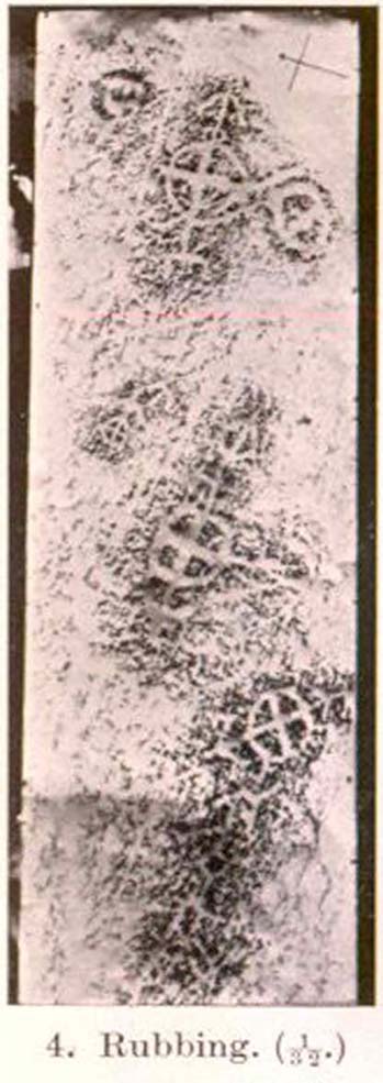
“Examination of the rough and sloping rock surface revealed an interesting group of inscribed figures, confined to an area of about 8 by 2½ feet, four of which included a cross within a circle. The figures are difficult to discern, except when thrown into relief by early morning sunlight, but are clearly demonstrated on a rubbing.
Cormack’s 1952 rubbing of the carving
“The crosses may be described in three groups:
“Group 1 — a) Near the upper edge of the rock is a cross within a circle of 8-inch diameter. The vertical axis of the cross is extended below the circle for 4 inches, resting on an ill-defined rectangular base, and upwards for 5 inches to form an arrow-head with 3-inch barbs. At the junction of the shaft of the arrow with the top of the circle is a pair of contiguous rings of about 1-inch diameter. The cross is deeply cut, to about a half-inch depth, with equal arms 4 inches long and 1 inch broad. The left arm of the cross extends beyond the circle, but this may be due to the circle being slightly excentric in relation to the cross. The lower right quadrant of the circle is marred by a natural crevice in the rock, but careful examination shows that the circle does not cut the right arm of the cross.
b) On each side of this figure is a roughly circular marking, one about 4 inches above and to the left, of 3-inch diameter, and the other 2 inches to the right, of about 5-inch diameter. In each there is an indefinite depression across the centre.
“Group 2 — a) About a foot below and to the right of Group 1 there is a boldly cut cross within a 7-inch circle. Again the vertical arm of the cross is extended above and below the circle, downwards for 5 inches to a curved arrow-head with 4-inch barbs, and upwards as an equal armed 5-inch crosslet above which is a 4-inch circle with the central axis continued through it. (The junction of this axis through the circle with the top of the small cross is slightly angled.) The main cross and circle are cut to fully half an inch in depth and one inch in breadth, but the upper part of the figure is much less distinct.
b) About 8 inches to the left of the upper part of the above figure is a very faintly incised cross within a 2½-inch circle. It is difficult to discern on the rock, but can be seen in the photograph and is very clear on the rubbing. It also appears to have an arrow-head above it.
“Group 3 — a) A foot below and to the right of Group 2 is a clearly cut cross within a 6½-inch circle. A natural cleft in the rock has been used for one axis of the cross, which lies obliquely to the others already described, and this axis terminates in an arrow-head 3 inches below the circle, and another slightly smaller arrow-head is cut 2 inches above the circle; in each case the angle formed by the arrow being towards the circle.
b) Immediately below the last cross is a curious hieroglyph not easy to make out on the rubbing, but clear in the photograph. On an 18-inch vertical axis can be seen from above downwards an arrow-head, an oblique line to the left, a faint 2-inch circle, a transverse stroke, and finally two oblique lines to the right. A natural crevice to the left of the figure rather confuses the picture.”
Ron Morris’ (1981) description wasn’t as detailed and he was initially hesitant about using the site in his rock art survey of the area, as he thought it “most likely to be early christian” in nature and period. He changed his view after talking with an associate at Bergen University, who pointed out that the symbols found here up Glen Lochay were “exactly the same as Norway’s second commonest symbol, the ‘Cross-ring’, which is contemporary with their cup-and-ring series.” Morris described the carvings here as:
“3 ‘cross-rings’ and 7 other rings, some of which have traces of crosses within them. There are also grooves, some extending from a ‘cross’-line to form an ‘arrowhead’, and one group, with ring above, rather resembles a ‘man.’ Largest ring diameter, 20cm (8in) and greatest carving depth, 1cm (½in).”
Examples of the artistic symbolism found at this ‘Duncroisk Crosses Stone’ are scattered throughout western Europe from the Bronze Age period onwards: notably at Dowth and Clonfinloch in Ireland (Brennan 1983; Coffey 1912); Jonathan’s Cave, Fife (Simpson 1867); Valcamonica, Italy (Anati 1961); and all over Norway and Sweden (Coles 2005; Gelling & Davidson 1969; Janson 1966). In more recent times we find these curious symbols etched inside the prehistoric chamber of Ty Illtud (Grinsell 1981) — but these are thought to be later additions. However, the universal nature given to such interconnecting symbols such as those found here is, simply, ritual magick. We find it across the Himalayas, Africa, north and south America – just about everywhere. It would be quite wrong to believe that the presence of an encircled ‘cross’ on this stone relates it to a christian belief system, as such a motif is found in many non- and pre-christian societies with a mythic nature akin to that of the swastika, i.e., of a world unfolding or emerging from a centre-point and the arms of the ‘cross’ outwards defining the directions and boundaries of any specified cosmology: be it landscape, heavens, spirit worlds, pregnant belly, etc.
Solar cross? Eye? Vulva?…or dancing human figure?
As Cormack (1952) described, the respective groups of carvings are integrally linked by an interconnecting line that joins the symbols in the respective groups to the other symbols. The fact that the connecting ‘lines’ are natural is meaningful in the relationship between humans and Nature; but moreover, the connecting line linking the symbols strongly implies sequential reasoning and magickal import. Indeed, these three distinct clusters (see Cormack’s rubbing) are functionally akin to magickal sigils, examples of which are found across the ancient and modern world. This is a notion that must be given serious consideration as a function in the carved stone of ‘Duncroisk 4’. Equally we can see in one section of the carving what may be a dancing human figurine, very much like rock carvings found elsewhere in Europe and beyond.
Both Erich Neumann (1973) and Alex Marshack (1972), for slightly different reasons, would also see the images carved here as early expressions of human development: either through i) the emergence of archetypal patterns and the interpretative interplay of the ego, or ii) the intellectual evolution of magickal appliance, whereby imagery and human action are recognized as meaningful in a wider natural sense. In the case of Duncroisk 4 it would more likely possess magickal import, as symbols were much more than ‘art’ and possessed meaning on several interconnecting levels, one of which being ritual function — an element that modern archaeology is slowly learning to incorporate into its analyses.
Dancing Siberian ShamanDancing shaman figure?
A more in-depth comparative essay is really needed to give a clearer exposition defining the nature of this carving… My personal view is that the carving represents, not some solar design, but one of Britain’s earliest artistic examples of human beings, in this case dancing and beating a drum or bodhran. It may indeed be the earliest pictorial example of a bodhran in the country. I’d say so. There is also the distinct possibility that the dancing figure is a shaman. We have many petroglyphs from all over the world that highlight such a character, integral to all early cultures—and this is as likely a contender as any for such a figure. (see Gough 1999; Whitley 2000, etc) It may however, be a warrior with a shield. You see the problems we can have with these damn carvings! 🙂
Folklore
This carved rock is said by local people to have been where a ‘Celtic’ saint delivered sermons to the heathen populace. The saint concerned is likely to be the one who tradition tells gave his name to the small glen immediately across the track from here: St. Charmaig. Halfway up the small glen is a small cave, barely accessible, with untouched remains of dried roots and other elements of human habitation therein. A few hundred yards to the north in old Finn’s Glen, is the forgotten Waterfall of the Oracle which sometimes isn’t even there!
References:
Anati, Emmanuel, Camonica Valley, Alfred Knopf: New York 1961.
Brennan, Martin, The Stars and the Stones: Ancient Art and Astronomy in Ireland, Thames & Hudson: London 1983.
Coffey, George, New Grange and other Incised Tumuli in Ireland, Dolphin: Poole 1977.
Coles, John, Shadows of a Northern Past: Rock Carvings of Bohuslan and Ostfold, Oxbow: Oxford 2005.
Grinsell, Leslie V., “The Later History of Ty Illtud,” in Archaeologia Cambrensis, 131, 1981.
Janson, Sverker & Westman, David, Rock-Carvings at Fiskeby, Esselte AB: Stockholm 1966.
Kuhn, Herbert, The Rock Pictures of Europe, Sidgwick & Jackson: London 1956.
Marshack, Alexander, The Roots of Civilization: The Cognitive Beginnings of Man’s First Art, Symbol and Notation, Weidenfeld & Nicolson: London 1972.
Morris, Ronald W.B., The Prehistoric Rock Art of Southern Scotland, BAR 86: Oxford 1981.Neumann, Erich, The Origins and History of Consciousness, Bollingen Princeton University Press: New York 1973.
Royal Commission on the Ancient & Historical Monuments of Scotland, Archaeological Sites and Monuments of Stirling District, Central Region, Society of Antiquaries of Scotland 1979.
Simpson, James, Archaic Sculpturings of Cups, Circles, etc., Upon Stones and Rocks in Scotland, England and other Countries, Edmonston & Douglas: Edinburgh 1867.
Whitley, D.S., The Art of the Shaman: Rock Art of California, University of Utah Press 2000.
John Dixon took a bunch of us on a pleasant amble here via the Fair Oak Circle site. From Fair Oak, go round the back of the farm and past the small cluster of hidden cottages, then bear right down the dirt-track and up the slope, then cross the field in front of you, going over the stile, following the footpath round the eastern edge of the slightly limestone New Laund Hill, and down again, thru the gate. From here, head diagonally across the field 150 yards towards the fencing at the woodland edge. Over the fence, into the trees, head halfway down the steep-ish slope and keep your eyes peeled for the rocky outcrop nearly halfway down. Alternatively, an easier way here is apparently from the Inn at Whitewell. Go across the river via the stepping stones (or wade!) and follow the footpath uphill towards a farm, where you’ll find a large steel gate on the left that leads into the woods. Here there are 2 paths: follow the higher of the two until it starts bearing to the right. Once here, look up the hill to the right you’ll see the rock outcrop. The caves are there!
Archaeology & History
Smaller Fairy Hole
There are at least 3 caves here, close to each other along the edge of the small footpath a few yards apart. The small rounded entrance of the northernmost one (photo, right) is reported by English Heritage to have had no human remains found therein, but further investigation is required here. The main cave however is where intriguing prehistoric finds were located. It appears that the entrance was deliberately built-up and blocked by stone walling a few yards inwards, giving the remains found therein a state of protection and sanctity. Writer and historian John Dixon (2004) tells what was in the cave:
“In 1946, an excavation was carried out on the site by the archaeologist Reginald C. Musson. In front of the larger cave is a flat platform on which evidence of Bronze Age daily life was found. This included animal bones, a pebble pounder (used to extract marrow from bones) and shards of a food vessel.
“All that survived of this tripartite collared urn was a large rim-collar shard, two fragments displaying neck/shoulder/body elements and five smaller pieces, probably from the base of the body. This is the only collared urn to have been found in a cave in Lancashire. Its tripartite Pennine form assigns it to an early Bronze Age date.”
The main Fairy HolePlan of cave chamber (after J.Dixon 2004)
The artificial walled entrance may not merely have been an ingredient giving sanctity to the place, but this could well have been a site for ritual shamanic practices, including prolonged rites of passage and death rituals (authentic ones, not the modern pagan nonsense). The ‘ritual death’ elements are highly probable here for, as John Michell (1975) told, caverns and crevasses are “most responsive to the necromancer’s invocation”. It’s geomancy, spirit association and the archaeological finds therein are strongly suggestive of this usage. (Eliade 1989, 1995; Maringer 1960, etc) Bearing this in mind, it is of some concern regarding the individual who thought it wise to spray-paint his name against the wall of the cave entrance (see photo); for many are those even in these days of shallow minds who fall prey to the car-crashes and creeping madness brought upon themselves by desecrating ancestral sites of ritual magick. It would be intriguing to keep a prolonged eye on the ‘Forsh’ who painted his ego in this cave of dead spirits…
Folklore
Not surprisingly, the little people hold legend here. Jessica Lofthouse (1946) found tales of these ancient peoples in several places close by, but at the Fairy Caves specifically,
“everyone knew that these little caves in the limestone at Whitewell were the homes of the little folk.”
…And in relation to the ingredient mentioned above, about ritual use of the cave in ancient times: are there any serious ritual magickians who’ve spent time working in this cave, overnight or longer, and who can let us know of their encounters here? (long shot, I know – but it’s worth asking, considering the probable use of the place) Or perhaps spontaneous encounters of other people here…