Go all the way up and through Heptonstall village until you reach the hamlet of Slack, by the road junction. From here walk down the road as if you’re going back into Hebden for less than 200 yards, then take the footpath on the left downhill and walk along. After a couple of stiles, keep a keen eye on the walling where the holly trees are, above the tree-line of Hardcastle Crags. You’ll see it soon enough!
Archaeology & History
Slack Bottom stone
Arguably the best-named standing stone in Britain, it was first discovered by Absalom Voist in the late 1990s (and first described in my Old Stones of Elmet), hiding away in the more modern walling, beneath a holly tree. But the stone itself is very nicely eroded and seems of good age, aswell as being a good near-six-foot tall specimen of a standing stone, just above the tree-line south of Hebden Dale. The stone gets its name from the fact that it’s at the bottom end of Slack village (which is actually called ‘Slack Bottom’ – with a house-sign there above the door to prove it!). It may be part of what was originally some original Iron Age walling instead of an authentic standing stone — tis hard to say really — but it’s a nice stone nonetheless. David Shepherd (2003) named this stone as ‘Dawson City Field’ in his later survey of megaliths in upper Calderdale.
Not far from here, along the edge of the woodland, is the little-known remains of an old cross-base which I think has eluded all previous surveys. Next time I’m up here, I’ll try remember to get some photos of the place!
References:
Bennett, Paul, The Old Stones of Elmet, Capall Bann: Milverton 2001.
Shepherd, David, ‘Prehistoric Activity in the Central South Pennines,’ in Proc. Halifax Ant. Soc., 2003.
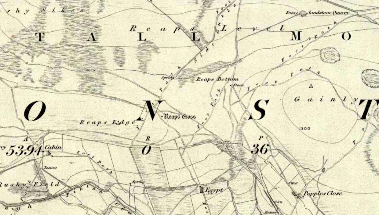
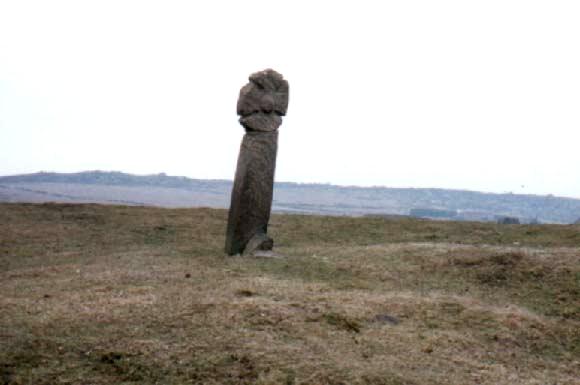
From Hebden Bridge go up the Heptonstall road, going round the village and onto and through Slack, keeping straight on the road until it goes uphill for a short distance, then levels out; then watch out for the small right-turn at Colden and the single-track road heading to a dead-end. Go right to the end, the very end, and go through the gate and walk up the track onto the moor. As you reach the ridge and the moorlands open up before you, note the small ‘standing stone’ on your right, about 10 yards off-path— and there, 100 yards the opposite direction to your west, the tall upright Reaps Cross is sat on the moortop. Y’ can’t miss it!
Archaeology & History
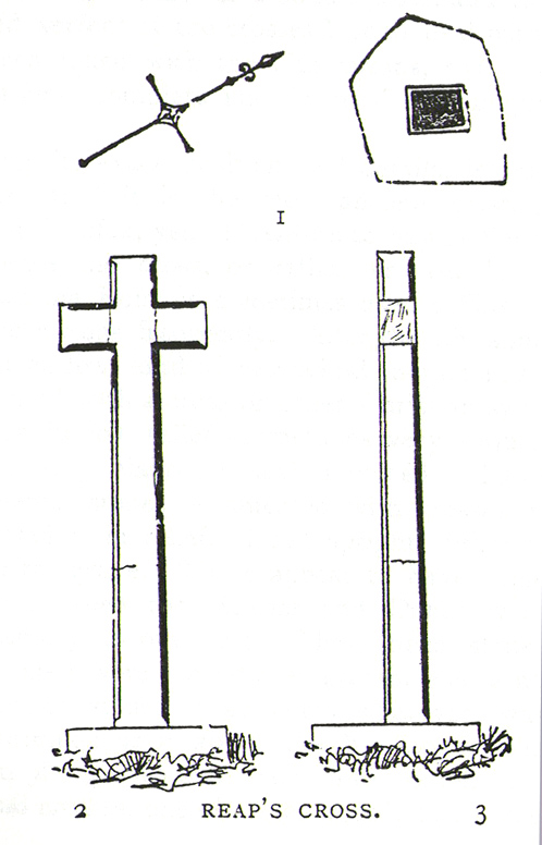
Found in the middle of a beautiful nowhere not far from the prehistoric standing stone on Standing Stone Hill, this old tall monolith was said to have stood as a marker beside the old road which ran from Halifax over the moors to Colne, until the more recent Widdop Road became the more preferred route. Known locally as the Long Stoop, in 1900 George Tyack said of it,
“This stone, which is composed of millstone grit, lay for a long tine broken and overthrown, but has in recent years been replaced on its original site and restored. It is a simple Latin cross standing twelve feet high amidst the heather of the Yorkshire moors.”
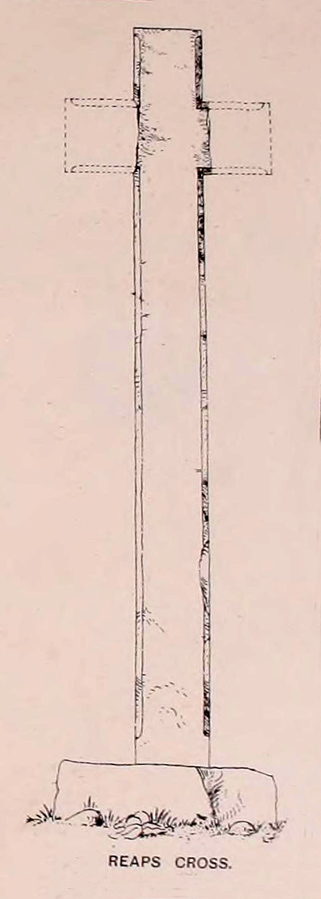
Longbottom’s 1897 sketch
Waddington’s 1884 sketch
Shortly before Tyack’s description, the local historian John Longbottom (1897) wrote a series of articles on the old stone crosses of the region and gave us this old sketch of the site (right). Even in his day the cross had been “wilfully thrown down” (probably by the screwy Puritans at that time), but a short time later it had been “repaired and restored to its original position.” In Longbottom’s day there were short ‘arms’ extending outwards from near the top of the obelisk, defining it as a distinct ‘cross’, but these have subsequently been lost following further local demolition attempts. He told how,
“Reaps Cross is known locally to shepherds, gamekeepers and farmers at ‘T’ Long Stoop’, and…apart from its religious associations, it forms an important landmark, now as in ancient times, to many a poor weary traveller crossing the dreary and lonesome hills between Lancashire and Yorkshire.”
The cross keeps getting knocked over, by both lightning and idiots of various persuasions; but thankfully the old fella keeps getting resurrected and put back in its place. It’s history is a curious one. When Clifford Byrne (1974) wrote about the site in his unpublished survey, he told how
“This cross appears to be of medieval origin and…in 1973 the monolith lay broken, one section lying in the grass, whilst the other section still stood in the pedestal. It is seen to have been broken once before, for the remains of iron clamps are seen on both sections. The arms have been broken off in some age… A local farmer insisted that the correct name was Ralphs Cross not Reaps Cross, and it should be noted that a section of moor at Widdop (the valley with the high cliffs) is named after a Ralph.”
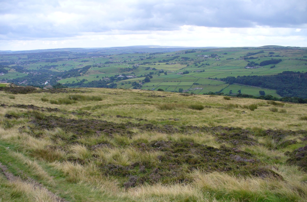
Standing some 12 feet tall, this is the highest of all the crosses in West Yorkshire and obviously some considerable work went into its creation all those centuries ago. Nobody is sure when it was first made, but the educated guess is 12th century. Why it was erected here, way off from anywhere in the middle of the wild moors, is equally puzzling. It may have had something to do with the nearby medicinal springs; it may have been as a guide-post to travellers—”to Rastric Greave”, according to Waddington (1884); it may have marked an ancient religious route; or it may have distracted people away from the prehistoric upright that gave its name to Standing Stone Hill, a short distance to the west We simply don’t know. It’s well worth visiting though, as the moorland landscape up here is truly expansive and civilization seems thankfully centuries away…
Folklore
Local tradition told that the cross marked an old corpse route, along which the dead were carried before being buried at Heptonstall. Here at Reaps Cross, the bodies were rested by the weary travellers. If this is true, it is probable that the ancient standing stone more than half-a-mile to the west once had something to do with such old rites and routes.
References:
Bennett, Paul, The Old Stones of Elmet, Capall Bann: Milverton 2001.
Byrne, Clifford, A Survey of the Ancient Wayside Crosses in North-East Lancashire, unpublished MS, 1974.
Longbottom, John, “Ancient Crosses in Halifax Parish – Part 2,” in Halifax Naturalist, 2:8, June 1897.
Taylor, Henry, The Ancient Crosses and Holy Wells of Lancashire, Sherratt & Hughes: Manchester 1906.
Tyack, George, The Cross in Ritual, Architecture and Art, William Andrews: London 1900.
Waddington, J. Arthur, “The Crosses in and Around Burnley,” in Transactions of the Burnley Literary & Scientific Club, volume 1, 1884.
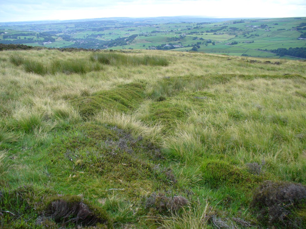
Near the centre of this photo, the large ‘ring’ can be seen
From Midgley go west along Height Road and take the track up on your right, at the tree-lined bend, up Foster Clough and onto the moor as if you’re gonna go to Churn Milk Joan. As you reach the footpath at the quarries up the hill, go to the top of them and take the small footpath where the land levels-out and head east towards the walling. Just a hundred yards or so before the walling, keep your eyes peeled, cos you’re damn close!
Archaeology & History
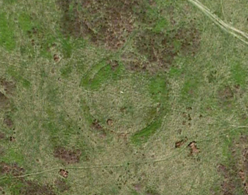
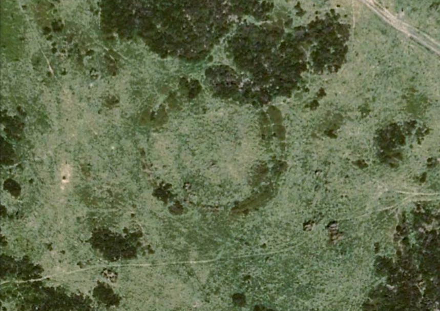
Best seen when looking down from the slopes above, this is a fascinating site that is lucky to still be here! For just a few yards to the west are extensive quarry works that could easily have destroyed the place had they continued. But thankfully we have here a near-perfect circular enclosure: measuring roughly 27 yards in diameter east-west, and about 25 yards north-south, the circumference around the outer-edge is approximately 82 yards (75m). It has all the appearance of an overgrown henge monument, with an outer bank and inner ditch, then a central flat arena—and it may indeed be such a monument—but until we have a decent excavation of the site, we’ll stick to calling it a simple enclosure—which it is!
Eastern arc of bank & ditch
The outer bank is very much overgrown, but as it runs round and defines this site, it measures 1-2 feet high most of the way, except on the westernmost spot, where it seems there may be an ‘entrance’. The inner ditch is only a couple of feet deep, again all the way round the monument. The internal level of the site is pretty flat, like most henges; but there seems to be a small central ‘cairn’ of some sort in the middle. Again, this is very overgrown by our traditional moorland vegetation.
Aerial image, 2009Aerial image, 2006
So what is it exactly? An enclosure, a settlement, or even (as local research student John Billingsley once suggested) a henge? Tis difficult to say for sure without further and more detailed archaeological excavation. My estimate is that the site is either Bronze- or Iron-Age in nature, and is definitely an ‘enclosure’ of some sort. We have located other prehistoric sites on the slopes just above here to the north, like the Crow Hill cairn circle and accompanying tumulus, remains of a neolithic settlement and a number of other small single cairns that are only visible when the heather has been burnt back. If you intend to explore any of the ancient sites sites on this moor, check this one out!
References:
Bennett, Paul, The Old Stones of Elmet, Capall Bann: Milverton 2001.
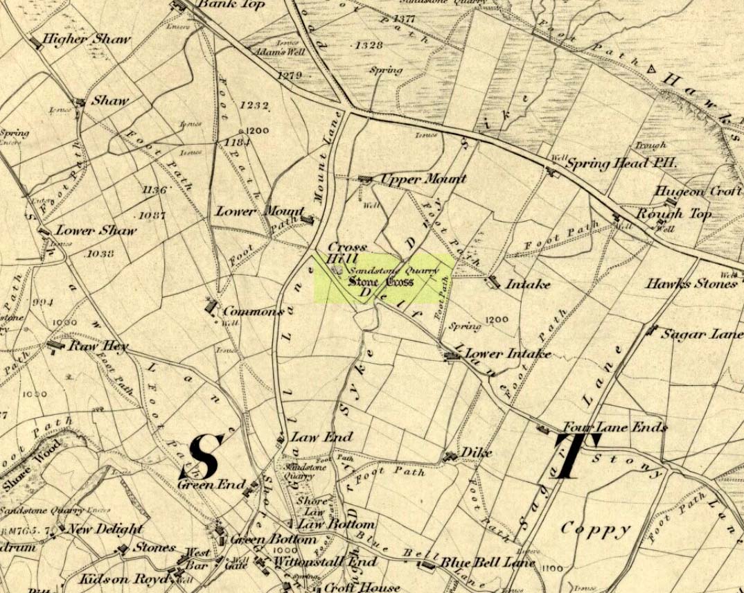
The site can be approached by going up the almost hidden long steep winding lane off the A646 in Cornholme; but if you don’t know the area it’s probably best approached from the well known Bride Stones, above Todmorden. From here, go west along the road running 100 yards or so above the Bride Stones, past the old pub, past Hawk Stones farm, and turning left downhill about a quarter-mile on. A coupla 100 yards down, there’s a track to your left. As you start walking along you’ll see a standing stone on the grassy rise in front of you on your left. That’s it!
Archaeology & History
Mount Cross on 1848 map
Said by local writer Geoff Boswell (1986) to be “the oldest religious memorial in Todmorden,” this old stone, more than 4-feet tall, is still in good condition and can be found beside the Old Causeway: a prehistoric trackway running between Lancashire and Yorkshire which is said by archaeologists to have been an old, but established trade route. It was suggested by some to have been erected as a cross as early as the 7th century. Generally known as the Mount Cross, it is also known as the Idol Cross, as legend reputes it to have been the site of pagan practices; hence its repute as being haunted. Its alleged heathen history is probably true (history records describe an old “rude stone” that was once found beneath the legendary Bride Stones nearby, which was moved many centuries back).
The Calderdale Council website tells that,
“Towards the bottom of the shaft on the NE side are what appears to be extremely faint traces of vine-scroll decoration which would suggest a fairly early date for the cross, possibly tenth or eleventh century. The irregularity of the carving overall tends to indicate that the cross is no earlier.”
Folklore
Said to have stood upon or beside a small tumulus until the 20th century. Jessica Lofthouse (1976) reported that a local farmer said of this stone. “Queer things happened here long since. They worshipped idols here.” Locally attributed to be haunted, the old stone was said to have a history of “uncanny happenings.”
References:
Bennett, P., The Old Stone Crosses of West Yorkshire, unpublished MS, 1995.
Boswell, Geoff, On the Tops around Todmorden, Delta G: Todmorden 1986.
Lofthouse, Jessica, North Country Folklore, Hale: London 1976.
The site is usually invisible, being under the waters of Walshaw Dean Middle Reservoir. But in good droughts you can catch a glimpse of the place. So take the Widdop road as it’s known locally, from either Hebden Bridge up past Heptonstall, or from Burnley, Nelson & Colne side, and park-up by the pub a few hundred yards east of Widdop Reservoir. Walk a few hundred yards back down the road (east) and take the dirt-track on the other side of the road on the Calder-Aire link leading to the Pennine Way. Walk up past the first reservoir, keeping to its west-side, until you reach the Lodge house where the second lake appears. Now, if the water’s down, walk along its western-edge for about 50 yards, looking into the dried flat ahead of you and you’ll see the loose ring of small stones. That’s it! Or as Mr Roth described the place in 1906, “The position of the circle is on the left-hand side of the valley going up, a few yards above the dam of the second reservoir.”
Archaeology & History
Earliest photo of the circle
This is a somewhat bizarre archaeological site, whose nature we may never fully recover. Although listed and scheduled as a plain stone circle by Aubrey Burl (2000) and others, both the placement and structure of the site implies a more funerary aspect to it. This was suggested by Ling Roth (1906) when he first wrote about it. But for me, the position of the site in the landscape calls into question the archetypal ‘stone circle’ category, as it is somewhat hemmed-in both east and west, with limited views north, and only a good view of open lands to the south (summer). It’s just a bit odd when compared to other megalithic rings in the Pennines. But perhaps this ‘privacy’ was intended — as there is only scattered evidence of other human activity in this valley and on the moors above. Perhaps this site was meant to be ‘cut off’ from the rest of the world. We might never know…
There is also the peculiar addition inside this stone circle of an arc of walling facing southeast, which is unique in this part of Britain. But this walling seems to have been a later addition and has the hallmarks of being some small shelter, or even an early grouse-shooting butt (there’s tons of game-birds here, and this would be an excellent spot to shoot from) This internal wall may have been constructed from stone that came from the circle itself: perhaps in a rubble wall, perhaps an internal cairn. It seems likely. Mr H. Ling Roth (1906) also mentions this feature in what was the first description of the site, where he told:
“The stone circle at Walshaw Dean Reservoir…was discovered by Mr W. Patteson, the resident engineer, in July 1902. The circle consists of ten irregular stones apparently local rock, varying considerably in size, one measured 6ft 3in (1.9m) long and stood about 30 inches (76cm) above the clay when the peat surface was removed. Whether the stones are deeply embedded has not been ascertained, but where they were covered by the peat a clear white band is apparent. The circle is 36 feet (11 metres) is diameter and of very fair exactitude. Inside the circle as shewn on the plan and in the view there was a rouhg carved wall which measured across the ends 12ft (3.7m). The wall had been partly pulled down and reset immediately before examination by a party of visitors soon after the discovery. Its presence in the circle may be fortuitous, but after the two unsystematic disturbances to which the ground had been subjected, it is not possible to form an opinion about it. That something had been buried in the centre of the circle is probable when we bear in mind the circumstances of stone circles elsewhere, but an examination shewed only that the ground had been disturbed and Mr Patteson explained to me that such disturbance was not of recent date.”
To my knowledge, no subsequent excavation of the site has ever been done, but it would appear that the waters have washed part of the site away and any remains that may once have been found within the ring have been discarded by more than a century of erosion. Traces of small walled structures have also been noted close to the circle in recent years, suggestive of settlement remains. On a TNA outing last year, we also found previously unrecorded prehistoric remains on this hills above here. When Geoffrey Watson (1952) wrote his survey on prehistoric Calderdale, he suggested that the Walshaw Circle may have been placed alongside the branch of an early trade route running along the northern edge of the valley. Not so sure misself…
References:
Bennett, Paul, The Old Stones of Elmet, Capall Bann: Milverton 2001.
Burl, Aubrey, The Stone Circles of Britain, Ireland and Brittany, Yale University Press 2000.
Roth, H. Ling, The Yorkshire Coiners, 1767-1783; and Notes on Old and Prehistoric Halifax, F.King: Halifax 1906.
Watson, Geoffrey G., Early Man in the Halifax District, HSS: Halifax 1952.
Take the Heptonstall road up from Hebden Bridge, going round the village (not into it) and head through Slack and onto Colden. Just as the road begins to go downhill to Colden, note the small single-track road on your right called Edge Road. Go on here for a good mile until it becomes a dirt-track and there, on your left, is the half-run-down old farmhouse called New Edge. Just yards past it, off to the right by the trackside, you’ll see this large copper-coloured stone basin oozing with the same-coloured liquid.
Archaeology & History
New Edge Chalybeate, above Colden
This is one of what Thomas Short (1724) called “the ten thousand chalybeats”, or iron-bearing springs, inhabiting the Yorkshire uplands — but he didn’t include this site in his huge survey. But it’s a beauty amongst chalybeates, as a visit here clearly shows! The well is one of two found on either side of the old building known as New Edge (as contrasted with Old Edge, a little further along the lane), and its waters trickle gently from the old stone trough.
The waters are undoubtedly enriched with large amounts of iron, as the photo here shows, giving the waters clear medicinal value. In tasting them, not only do the waters give you that copper-coloured hue, but you can clearly taste the minerals in the water. As with other iron-bearing springs, the water from the New Edge spring is good for the blood, good for anæmia, loss of energy and a low immune system.
References:
Short, Thomas, The Natural, Experimental and Medicinal History of the Mineral Waters of Derbyshire, Lincolnshire and Yorkshire, privately printed: London 1734.
Follow the directions to reach Churn Milk Joan, the head 100 yards east till reaching the crossing of footpaths, beneath Crow Hill. Take the northern (left) route and keep walking. Half a mile along you’ll see the tall upright stone to your left. You can’t really miss it!
Archaeology & History
The Greenwood Stone is an old boundary stone and is not prehistoric. It stands more than four feet tall. I first visited the site in 1988 in the company of several folklore and antiquarian writers, including Andy Roberts, Edna Whelan and Graeme Chappell. Twas a good day and coincided with a small collection of Psilocybes being gathered!
The tall upright is a boundary stone that was erected in 1775, as evidenced by the date carved on its southern face. I must emphasize however that this was not when the stone came to acquire its name: this was defined in 1594 as evidenced by a boundary perambulation written that year where it is described as being recumbent: “thence to one lying stone, newly named Greenwood Stone.” About 10-15 yards away is what may have been that very “lying stone,” the original Greenwood Stone, half-buried in the heather some six or seven feet long. It is possible this may have stood upright in the distant past.
Greenwood Stone, looking south
Moving about 75 yards south we come across another small standing stone at 1360 feet (412m) above sea level. This I’ve called the ‘Greenwood B stone’. It was marked on an old map as a boundary stone and is distinctly shaped to stand upright, marking a point separating the moors of Midgley and Wadsworth. When stood upright it is just visible on the horizon when looking from the Miller’s Grave prehistoric tomb several hundred yards east of here and is close to being an equinox indicator.
References:
Bennett, Paul, The Old Stones of Elmet, Capall Bann: Milverton 2001.
From Mytholmroyd, go up the Cragg Vale Road, then 2 miles up take the road steep on your right down and round St. John’s Church, then keep going along the road up to Withens. About a mile up, a road turns sharply right. Go up here for a few hundred yards, past the trees, and 100 yards on the road splits in a ‘V’. Stop here. Go into the field on your left which slopes downhill and less than 100 yards down you’ll see the large long stone laid in the grass. That’s it!
Archaeology & History
The fallen stone, with Teddy! (image courtesy ‘QDanT’)
Included in the Addenda of The Old Stones of Elmet (p.222), here is a recumbent monolith more than 8 feet long and 6 feet across which really needs to be resurrected as it would be an impressive sight! Found halfway up Withens Clough, a local land-owner told me it was one in a row of several such stones, though no trace of the others can be found. Found in the appropriately called Standing Stone Fields, it was last shown on the 1850 OS-map, as the attached illustration shows and is positioned just above the “S” of the smaller highlighted “standing stone”, just where the little blob is! The small valley to its immediate west is called Rudstoop, from which I give the stone its name.
A description of the site is given in F.A. Leyland’s scarce commentary on the History of Halifax (c.1867), where he wrote:
“Standing Stone Fields: Not far distant from Hill Top, in this township (Erringden), there is a rough piece of ground known by this name. It is situated on the slope of the same hill as the remain last described and commands a view of the northern side of Sowerby, with the outlines and rocks of Langfield and the Withens. The locality was anciently the site of a number of upright single stones: most of these have been broken up and used in the construction of the adjoining fences. But one, the last of the series, which the quarrying operations on the spot respected during the whole time they were carried on, was undermined and overthrown a few years ago, by a number of mischievous boys. The rock is a slab of millstone grit, measuring upwards of 9 feet in length, 7 feet 8 inches in width, at the base, and 4 feet 9 inches at the top: at the latter point it is 9 inches thick, and is 1 foot 6 thick at the base. The remain has, originally, been pyramidal in form, but the apex has been either broken off by violence or reduced to its present dimensions by decay.”
An impression of the land here indicates the other, lost monoliths, were in a row which headed east from here, towards the cup-and ring-marked ‘Upper Lumb Stone’. There is also the possibility that these monoliths were aligned with the enigmatic Two Lads cairns less than a mile SW of here.
Well worth checking out!
References:
Bennett, Paul, The Old Stones of Elmet, Capall Bann: Milveton 2001.
Leyland, F.A., The History and Antiquities of the Parish of Halifax, by the Reverend John Watson, M.A., R.Leyland: Halifax n.d. (c.1867)
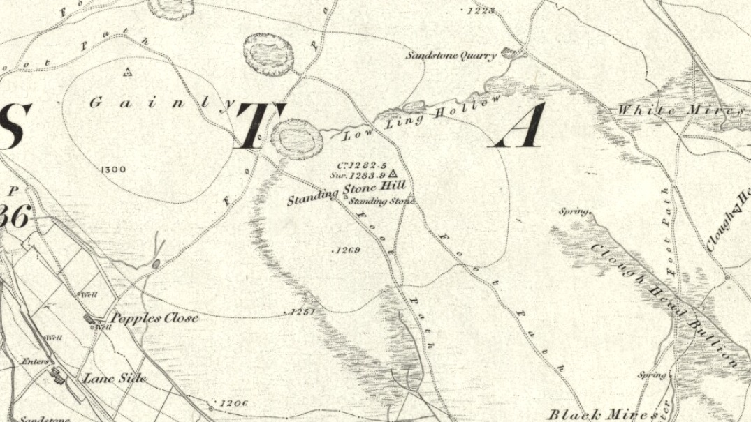
From Hebden Bridge, go up the Heptonstall road, going round the village and onto and through Slack, keeping straight on the road until it goes uphill for a short distance, then levels out; then watch out for the small right-turn and the single-track road heading to a dead-end. Go right to the end, the very end, and go through the gate and walk up the track onto the moor. As you reach the ridge and the moorlands north open-up before you, note the small ‘standing stone’ on your right, about 10 yards off-path. Go up past it, following the path up the small hill and keep going till you hit the triangulation pillar. From here, keep walking on the same path ESE for another 200 yards. Y’ can’t miss it!
Archaeology & History
The name of the place rather gives the game away a bit, yeah…? When I first moved to nearby Hebden Bridge in the 1990s, I noted the conspicuous place-name ‘Standing Stone Hill’ on the maps — so when I met local earth-mystery enthusiast John Billingsley and asked him about any remains up here, he said, with conviction, “there’s nowt up there!” (or words to that effect)
“Are y’ sure?” I asked. To which he repeated his dictum. But I wasn’t convinced of his words and, like any decent chap with energy for old stones and such things, wouldn’t take ‘no’ for an answer and went to check for myself – and wasn’t too surprised when I found this lovely looking standing stone — and a fine specimen of a monolith it is indeed!
Standing stone, looking southStanding Stone, looking east
Although not a tall specimen by any means, this rounded and weather-worn upright has fine character and age to it. Standing more than 3 feet in height and nearly as wide, the stone has a faded but distinct artistic carving of the letter ‘T’ on its western face (which you can make out on the photo, hopefully). It was thought this may have been an old boundary marking, but the stone aint on any boundary line so possibly relates to some local family who marked it with that deluded notion of ‘ownership’ of this part of the desolate moors.
It’s a beautiful spot up here, out on its own. I’ve sat here many times, both alone and with good heathen friends, gazing across the endless silence on days coloured with snows, mists, bright sunshine and heavy rains. It has that feeling of solitude, of being forgotten, of being truly untouched.
Standing Stone Hill on 1851 map
There are a couple of other possible standing stones on this section of moorland. One in particular appears to have been taller in bygone times and is marked on the 1851 OS-map of the region about 100 yards southwest of the triangulation pillar (you’ll notice it on your right, off-path, as you’re walking towards the pillar—shown at the position on the map here, right). Further west is the tall medieval Reaps Cross, where corpses were rested in their journey over the moors.
References:
Bennett, Paul, The Old Stones of Elmet, Capall Bann: Milverton 2001.
Follow the same directions to find the Blackheath Circle, but instead of turning onto the golf course, keep going up the steep road until you reach the T-junction at the top; then turn left and go along the road for about 200 yards, past the second track on the left, keeping your eyes peeled across the small moorland to your left where you can see the rocks rising up. Walk along the footpath towards them. You can’t really miss the place!
Archaeology & History
The Bride at sunset – the fallen Groom to her left
If you’re a heathen or geologist and you aint seen this place, check it out – you won’t be disappointed! First mentioned in 1491, this has always been a place of some repute. Its legendary companion, the ‘Groom’, lays resting on the Earth after being felled sometime in the 17th century.
F.A. Leyland’s 1860s drawing
A beautiful, remarkable and powerful site of obvious veneration. First described in local deeds as early as 1491, there are a great number of severely weathered boulders all round here, many like frozen rock giants haunting a magickal landscape. The modern lore ascribes the stones to be dedicated to Bride, goddess of the Brigantian people. And like Her legendary triple-aspect, we find here in the landscape a triple aspect to the outcrops themselves: to the west are the Bride Stones; to the east, the Little Bride Stones; with the Great Bride Stones as the central group, surveying everything around here.
At the main complex is what is singularly known as the Bride itself: a great smooth upright pillar of stone fourteen feet tall and nine feet wide at the top, yet only about two feet wide near its base, seemingly defying natural law. Watson (1775) described, next to the Bride herself, “stood another large stone, called the Groom…(which) has been thrown down by the country people” – probably under order of the Church. Crossland (1902) told how the Bride also acquired the title, “T’ Bottle Neck,” because of the stone’s simulacrum of an upturned bottle.
The Bride & her Groom (laid on the earth)The ‘head’ or top of the Bride Stone
Scattered across the tops of the many rocks hereby are many “druid basins” as Harland and Wilkinson (1882) described them. Many of these are simply basins eroded over the millenia by the natural elements of wind and rain. It is possible that some of these basins were carved out by human hands, but it’s nigh on impossible to say for sure those that were and those that were not. If we could find a ring around at least one of them, it would help — but in all our searches all round here, we’ve yet to locate one complete cup-and-ring. So we must remain sceptical.
On the mundane etymological side of things, the excellent tract by F.A. Leyland (c.1867) suggested the Bride Stones actually had nothing to do with any goddess or heathenism, but derived simply from,
“the Anglo-Saxon adjective Βñáð, signifying broad, large, vast — hence the name of the three groups known as the Bride Stones. The name of The Groom, conferred on the prostrate remains, appears to have been suggested by the fanciful definition of the Saxon Brád, as given by (Watson).”
However, the modern place-name authority A.H. Smith (1963:3:174) says very simply that the name derives from “bryd, a bride.”
A “rude stone” was described in one tract as being a short distance below this great rock outcrop; it was turned into a cross by the local christian fanatics and moved a few hundred yards west, to a site that is now shown on modern OS-maps as the Mount Cross.
Folklore
Although local history records are silent over the ritual nature of these outcrops, tradition and folklore cited by the antiquarian Reverend John Watson (1775) tell them as a place of pagan worship. People were said to have married here, although whether such lore evolved from a misrepresentation of the title, Bride, is unsure. In the present day though there have been a number of people who have married here in recent years.
If the Brigantian goddess was venerated here, the date of the most active festivities would have been February 1-2, or Old Wives Feast day as it was known in the north. The modern witches Janet and Stewart Farrar, who wrote extensively about this deity (1987), said of Bride: “one is really speaking of the primordial Celtic Great Mother Herself,” i.e., the Earth Mother.
Telling of further lore, Watson said that weddings performed here in ages past stuck to an age-old tradition:
“during the ceremony, the groom stood by one of these pillars, and the bride by the other, the priests having their stations by the adjoining stones, the largest perhaps being appropriated to the arch-druid.”
New Age author Monica Sjoo felt the place “to have a special and uncanny power.” This almost understates the place: it is truly primal and possesses the virtues of strength, energy, birth and solace.
References:
Bennett, Paul, The Old Stones of Elmet, Capall Bann: Milverton 2001.
Crossland, Charles, “Place-Names in the Parish of Halifax in Relation to Surrounding Natural Features,” in Halifax Naturalist, volume 7, 1902.
Farrar, Janet & Stewart, The Witches’ Goddess, Hale: London 1987.
Harland, John & Wilkinson, T.T., Lancashire Folklore, John Heywood: Manchester 1882.
Leyland, F.A., The History and Antiquities of the Parish of Halifax, by the Reverend John Watson, M.A., R.Leyland: Halifax n.d. (c.1867).
Smith, A.H., The Place-Names of the West Riding of Yorkshire – volume 3, Cambridge University Press 1963.
Watson, John, The History and Antiquities of the Parish of Halifax, T. Lowndes: London 1775.