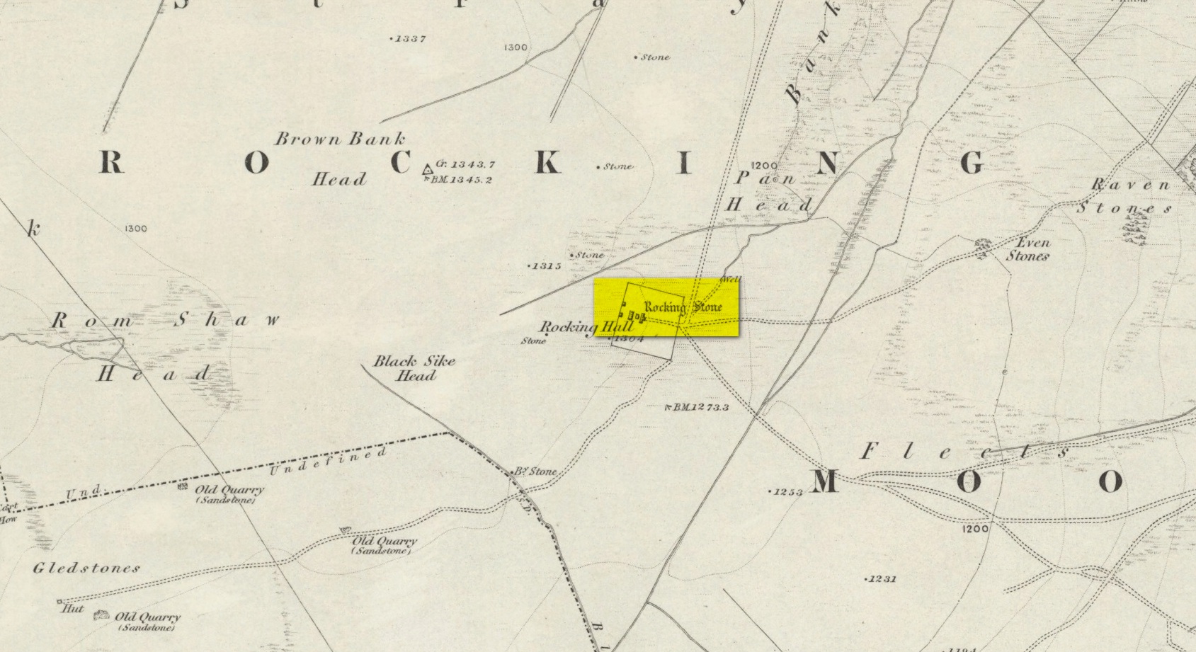
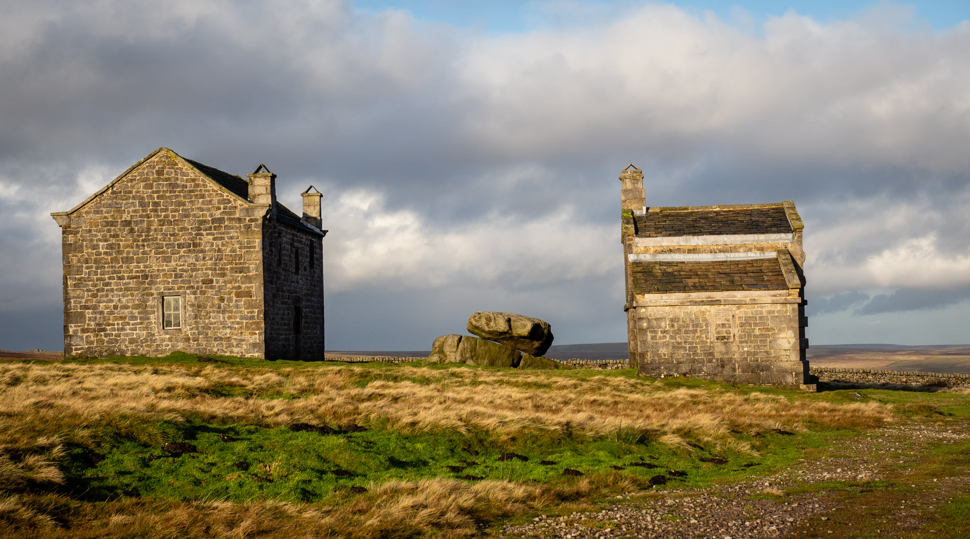
Visiting this site is a bittova walk across the moors, with probably the best route being along one of two footpaths from near the Outdoor Centre following (whichever is your preference) the moorland track or path westward onto the open landscape. Tis a 2½ mile walk before you reach two large buildings stuck high up in the middle of nowhere. Y’ can’t miss them. Equally unmissable is the large blatant rocking stone between the buildings. Gerron top of it!
Archaeology & History
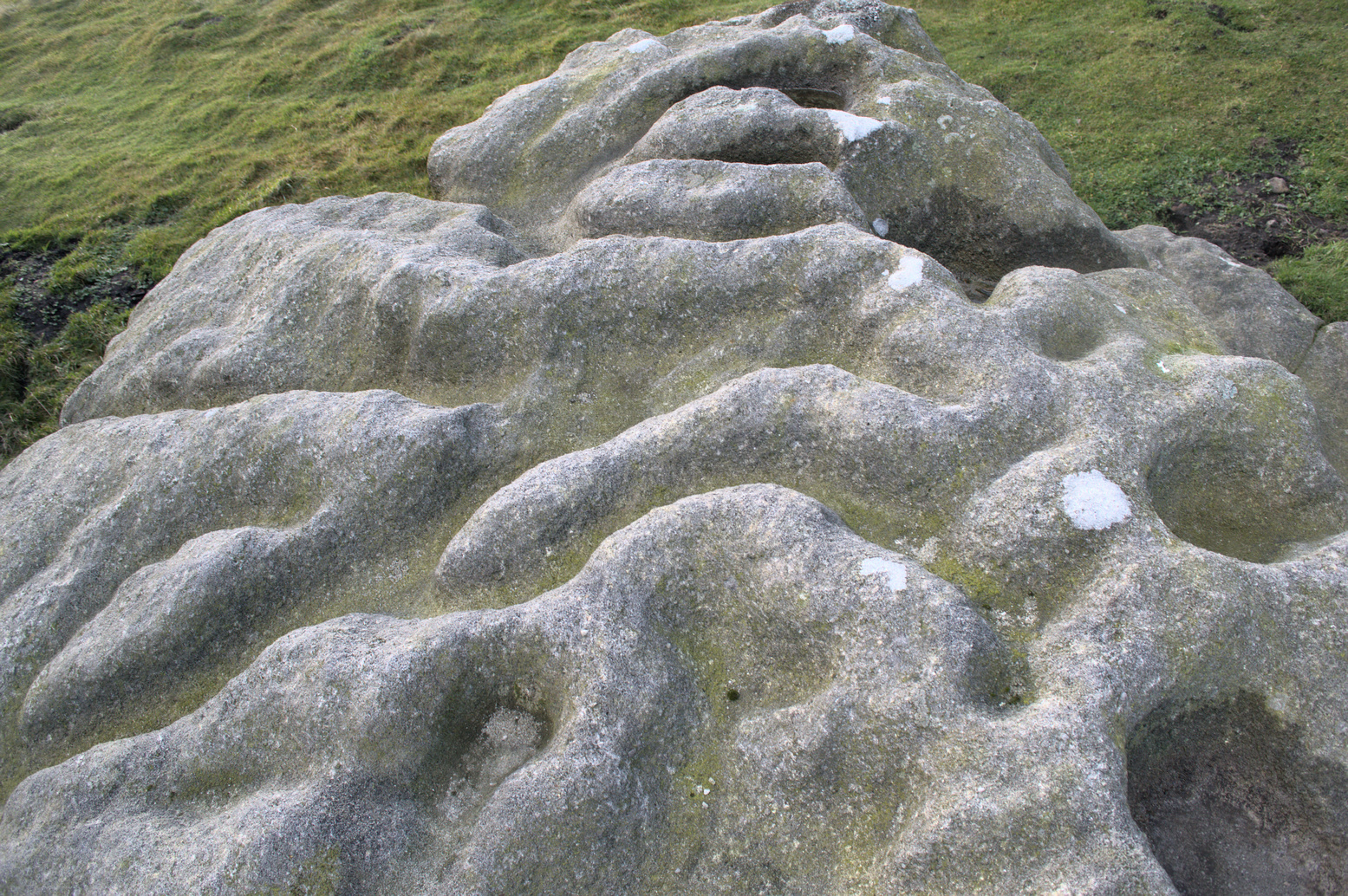
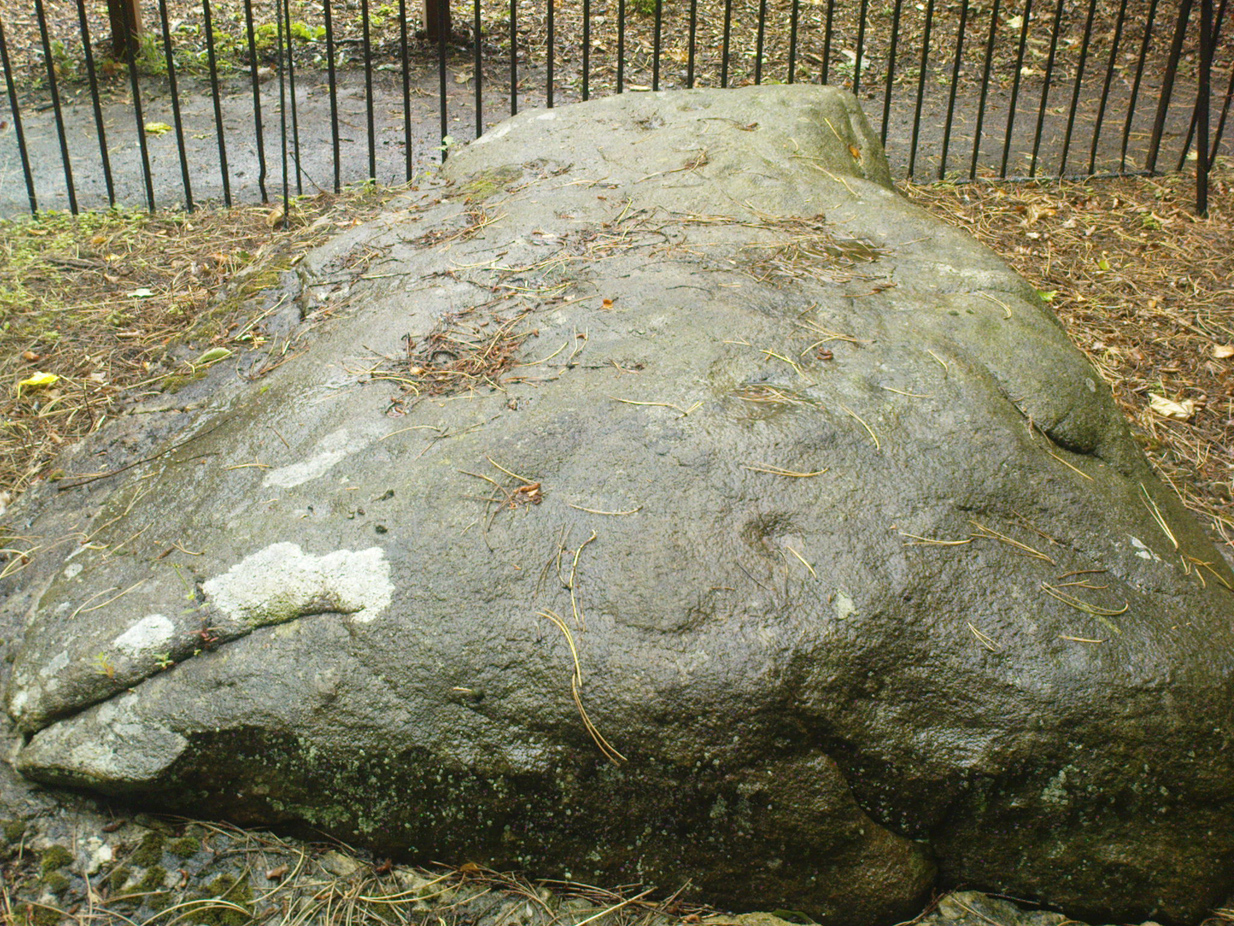
Rocking Stone, in situ
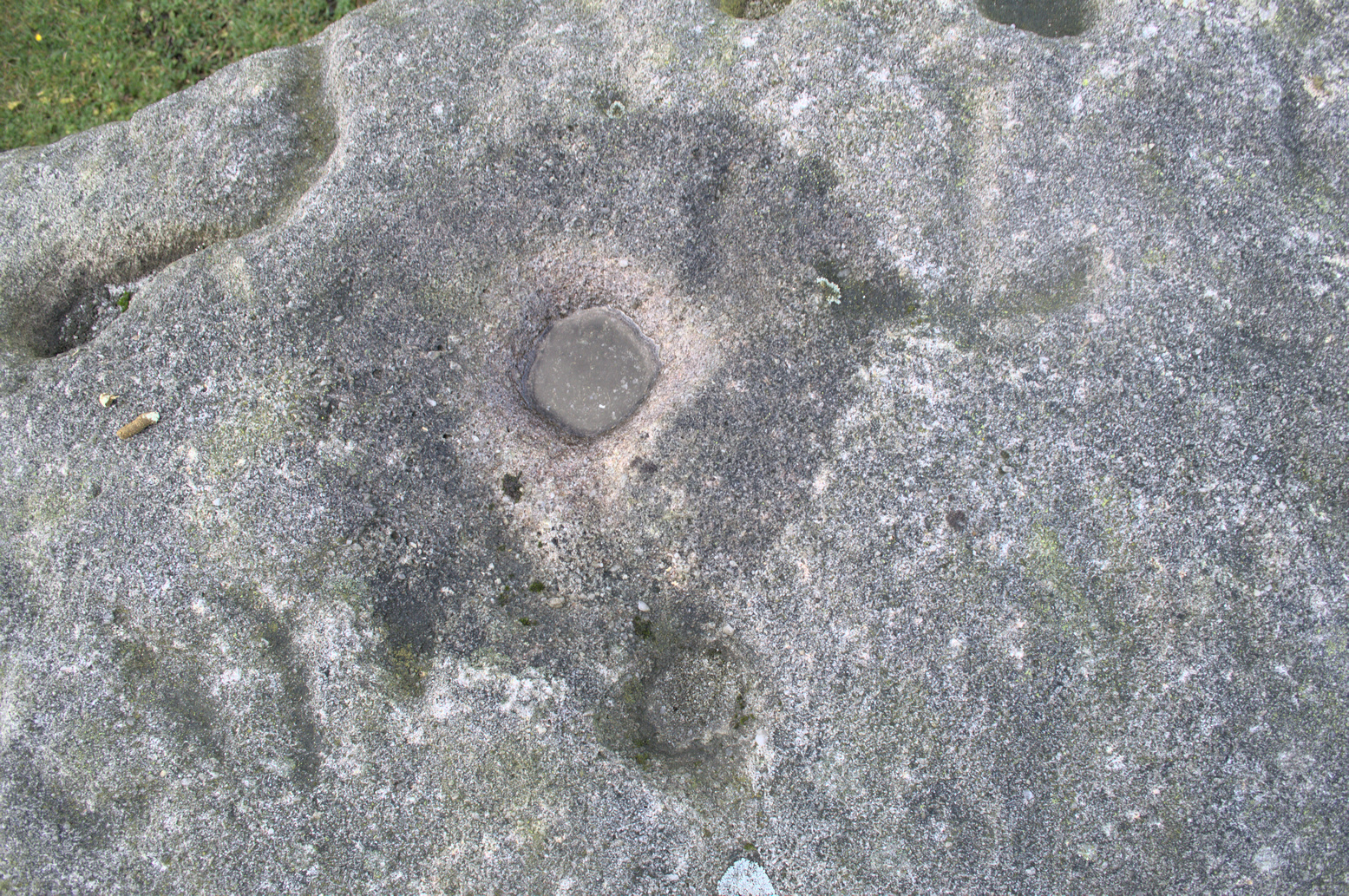
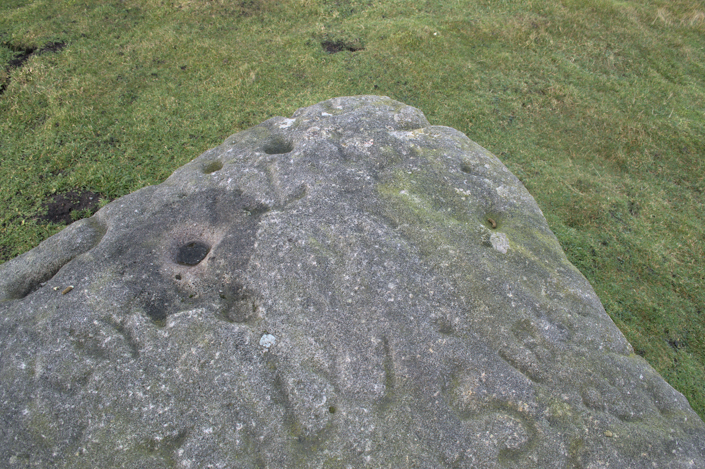
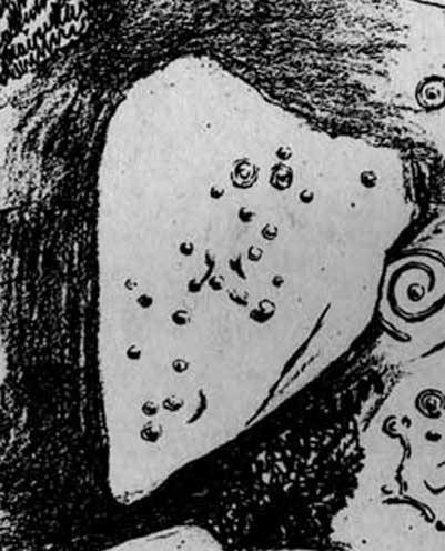
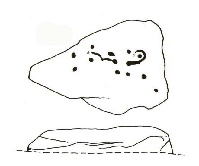
This impressive-looking rock that sits between the two buildings has a number of cup-markings of varying sizes across its topmost surface: some deep and some not-so-deep. There are perhaps as many as 20 of them on different parts of the stone, but some have been intruded on by more recent graffiti. On a recent visit to the site, photographer James Elkington and his young assistant MacKenzie, saw what looked like “a very faint ring around one of the cups” – which doesn’t surprise me. On one section of the stone we see a fascinating series of natural curves and geological undulations, some of which may have been modified a long time ago when the cupmarks were etched. But whether they were added to or not, it’s more than likely they’d have had some significance in the mythic nature of the rock.
The earliest description telling us that this possessed any prehistoric attributes seems to have been written by William Grainge (1871), in his huge work on the history of this region. He told that,
Faint ring highlightedSome of the many cups
“This rock…is eleven feet in length, seven feet six inches in breadth, and two feet six inches in thickness. The whole of the upper surface is thickly indented and grooved with cups and channels; the artificial character of which can be easily seen by anyone. This logan rests upon a lower rock, the upper surface of which is about three feet above the ground, fourteen feet in length, and nearly the same in breadth.”
Folklore
Curvaceous nature & cups
Although this yummy-looking geological sight no longer rocks, it wasn’t always that way. Indeed, according once more to the pen of Mr Grainge, although “it does not rock now, it has done so within living memory” – meaning that it would have been swaying at the beginning of the 19th century. We can only take his word for it. Also, as with many rocking stones the length and breadth of the land this, unsurprisingly it was adjudged to have been a place used by the druids.
References:
Grainge, William, The History and Topography of Harrogate and the Forest of Knaresborough, John Russell Smith: London 1871.
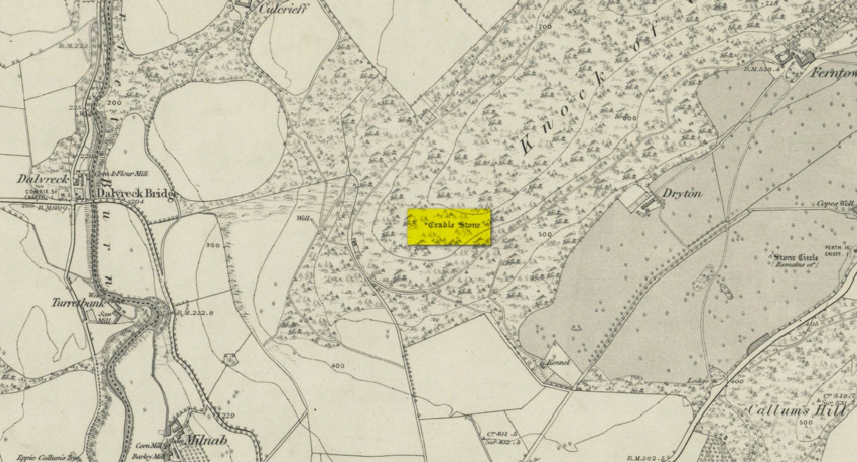
A bit troublesome to locate if you don’t know the area. Get into the town centre where the paved St George Square is by the main road. Cross the road and go up Hill Street, which runs straight into Ferntower Road. A few hundred yards up turn left up Ewanfield, all the way to the very end at Crieff Hydro. From here you’ll see the path uphill by the tennis courts. Walk up and past the holiday chalets until your hit the road that curls round the bottom of the woods. Go along until you find the car park and just above here by the roadside is a tourist board showing the Knock Walk footpath. The Cradle Stone is about 250 yards up the Knock Walk from here, 100 yards into the woods on the right.
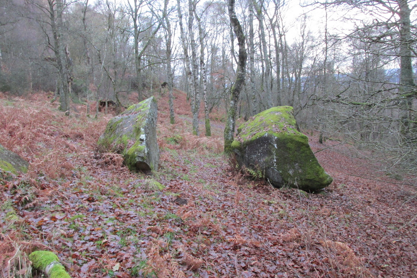
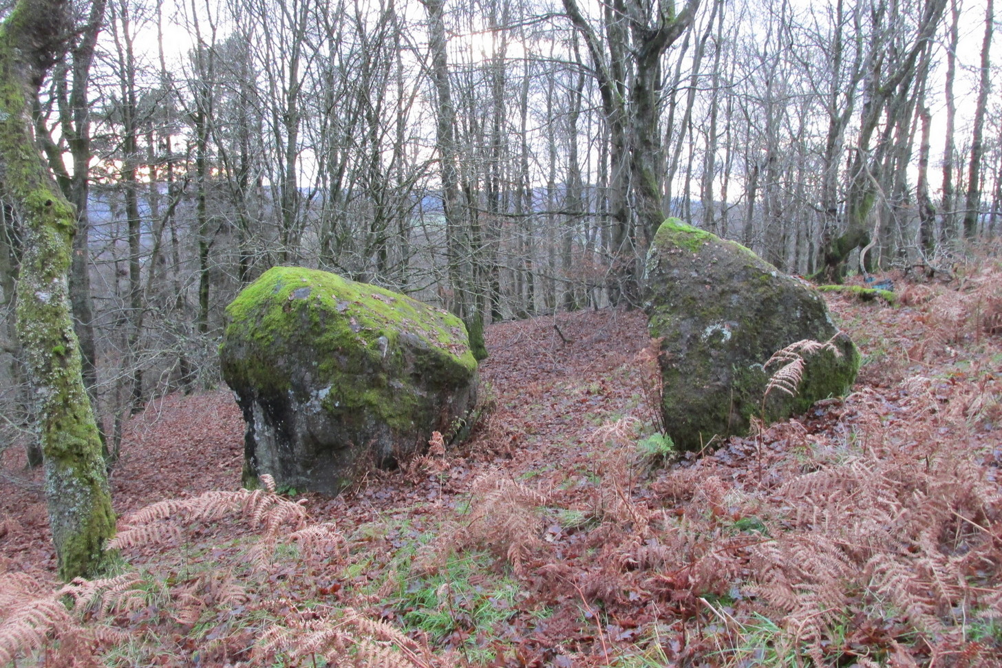
Archaeology & History
This large broken boulder is the result of it once living further up the hillside. One of Nature’s great forces then kicked the olde fella and he rolled down the hill to its present position. It was mentioned in a detailed 19th century geological survey by Mr Thomson (1836), where he told:
“At Crieff, in Perthshire, there occurs a series of low hills running parallel to the Grampians. These hills consist of old red sandstone and greywacke. On one of them, the Cnock, the village of Crieff is built. Upon the south-east side of this hill, towards the southern extremity, not far from the summit, there are deposited a number of boulder stones of syenitic granite. The largest of these is called the ‘Cradlestone’. It is nearly spherical, quite smooth on the surface, and 29 feet in circumference. It has been split in two by lightning, (according to the tradition of the place,) and one of the fragments has made one complete revolution down the hill and then stopped. The weight of this boulder is about 30 tons. The nearest mountains of syenitic granite, are those in the neighbourhood of Bennevis, distant more than 60 miles north-west…”
The stone was subsequently entered in Fred Cole’s (1911) outstanding survey of the local megaliths, although acknowledged it has having no archaeological pedigree. The Cradle Stone, he wrote, is
“the appellation printed in Old English lettering on the Ordnance Map, given to one of two huge boulders difficult to find in the fir-woods at the western extremity of the Knock, and at a height of nearly 600 feet, midway between Knockearn House and Culcrieff. On visiting the site, the conclusion became apparent that these two blocks were merely natural curiosities, and had no interest for the archaeologist beyond the name.”
Folklore
In volume 10 of the New Statistical Account it was told how local folklore attested the Cradle Stone as being where the babies came from, perhaps intimating some fertility legend long since forgotten.
The main thing attached to this giant broken stone is the old folk-tale that used to be more well-known in the 19th century than it is today. It was narrated at length in Macara’s (1881) fine pot pourri of local histories and legends and which I hope you can forgive me citing in its entirity here:
“In the memory of men still living, two well-known weavers, named James Livingstone and James M’Laren, lived in Barnkettick, at the west end of the town. Livingstone was a thorough wag, and M’Laren was somewhat of a simpleton. Livingstone was in the habit of telling his neighbour all sorts of extravagant stories about ghosts and witches. The facility with which the latter fraternity could turn themselves into hares and scamper about was an accepted fact, which M’Laren as truly believed as his Bible.
“The Rocking or Cradle Stone on the brow of the Knock, behind the town, was supposed to be of Druidical origin, and for ages drew forth the fear and wonder of the natives. A belief prevailed that something valuable was buried in its foundation, and worth lifting, if it could only be got at. Livingstone having heard of “Whang, the Miller” directed McLaren’s attention to the subject of valuable treasure being beneath the cradle stone, which was greedily swallowed, and he expressed his astonishment that no one tried digging for it.
“Livingstone suggested that they both should try it, and divide the spoil. M’Laren agreed, and it was resolved to make the attempt that night after dusk. The necessary picks and spades were soon borrowed. Livingstone called on an acquaint- ance or two, and informed them of the “ploy,” and they readily agreed to arrange and have some fun at the “howking” of the treasure.
“The acquaintances were up at the spot early, with a view to set some snares for hares, so that the journey would combine pleasure with profit. They had also provided a few “squibs” for contingencies. At the time appointed the two weavers, with their implements on their shoulders, arrived at the stone and set to work. M’Laren did so with strong impressions of a coming calamity, which soon made him feel the greatest terror. Livingstone worked with a will, and upbraided M’Laren with cowardice.
“With that a strange, unearthly sound came up the hill, and on looking round, a ball of fire was seen careering through the underwood. M’Laren felt queerish and almost speechless. Another hissing sound was heard, and the strange fire came nearer. Livingstone still wrought on, telling M’Laren never to heed, as these things were only bits of falling stars. M’Laren thought otherwise. They were in the neighbourhood of Monzie, where it was certain there were plenty of witches, and it was evident something “no canny” was brewing. He would have given anything to have been at his loom.
“In an instant three or four fiery darts from different directions came hissing along, and darted through the heath at their feet. M’Laren was paralysed with fear. Livingstone ceased work instantly, and jumping out of the trench he made, yelled he smelt brimstone, rushed from the stone and was lost in the darkness. Poor M’Laren’s limbs trembled like a leaf and were scarcely able to support him. As he was trying to follow his companion, another fire shower rained about him, and down the hill he went like a deer, yelling on Livingstone to wait on him.
“As he neared the parks above Milnab, the hares acid rabbits were scampering in all directions, and a few found their necks in the snares, which caused them to squeal at the pitch of their voices too. M’Laren being now thoroughly convinced that the witches were let loose, speed was added to his limbs, and with supernatural fleetness he bounded over all obstructions and found himself in an instant or two in his room, and jumped into bed. A cold sweat broke out all over his body and his heart beat with sharp thuds, shaking the bed. It was some time ere he could collect his scattered senses, so as to realise whether or not he was dreaming. The moisture in his eyes caused every blink of the fire to appear like the horrid hissing fire darts of the Knock. After a time he fell into a stupor, the recent events being still vividly before his mind.
“His cronies on the Knock tumbled amongst the heather and broom, shouting with joy at the success of the scheme. After giving vent to their excited feelings they went back to the Cradle Stone and lifted the picks and spades, and on their way home went round the snares and found a good “take.” As they were killing the hares, Livingstone suggested that a live one be taken to M’Laren, which was readily agreed to. On reaching home, Livingstone slipped into M’Laren’s house, and all seemed at rest. Creeping quietly ben to Jamie’s end of the bigging, he tied the live hare to the foot of his bed. As he was retiring he jostled against the hen roost and set the cock a-crowing, which so far roused Jamie that he thought it was scarcely morning yet. The cock crowed away, and soon the neighbouring roosts bestirred themselves, and all the cocks in the neighbourhood returned the vocal sound, as if it were morning.
“Poor Jamie, on reflecting, resolved that if he got over the present raising of “Auld Clootie” scathless, he would pledge himself never to trouble him or his again. As he thus pondered he thought he heard a strange pattering on the floor, and an occasional slight pull at the bed. On straining his eyes and looking floorwards he saw something not unlike a reputed witch moving about the foot of the bed. On closer observation this was fully confirmed, and he instinctively roared for help. His daft brother was now roused, and he roared also, and the hamlet dogs lent a willing voice. The wags who had collected outside rushed in, and on putting some fir roots on the fire the blaze showed Jamie, nearly demented, in bed, with his wearing clothes still on, and some dogs entering the room set a-worrying the hare. At the sight of well-known faces Jamie jumped out of bed. So much excited that it was feared that the joke had been carried rather far. Livingstone was still equal to the occasion, and drawing a bottle of whisky from his pocket handed round a few glasses, and in a short time “they didna care for deils a boddle.” Jamie was advised to divest himself of his clothes and go to bed, which he did, and soon fell into a deep sleep, and awakened next morning not much the worse. The affair got wind, and many a country fireside was made merry by the story of the Cradle Stone treasure.”
Macara, Duncan, Crieff: Its Tradtions and Characters, D. Macara: Edinburgh 1881.
Thomson, Thomas, Outlines of Mineralogy, Geology and Mineral Analysis – volume 2, Baldwin & Cradock: Edinburgh 1836.
Acknowledgements: Big thanks for use of the 1st edition OS-map in this site profile, Reproduced with the kind permission of the National Library of Scotland.
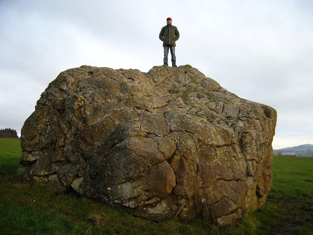
On the outer southern edge of Kilbarchan parish—right near the ancient boundary line itself—this giant stone of the druids is seems to be well-known by local folk. Located about 40 yards away from the sacred ‘St Bride’s Burn’ (her ‘Well’ is several hundred yards to the west), it was known to have been a rocking stone in early traditions, but as Glaswegian antiquarian Frank Mercer told us, “the stone no longer moves.” The creation myths underscoring its existence, as Robert Mackenzie (1902) told us, say
“This remarkable stone, thought by some to have been set up by the druids, and by others to have been carried hither by a glacier, is now believed to be the top of a buried lava cone rising through lavas of different kind.”
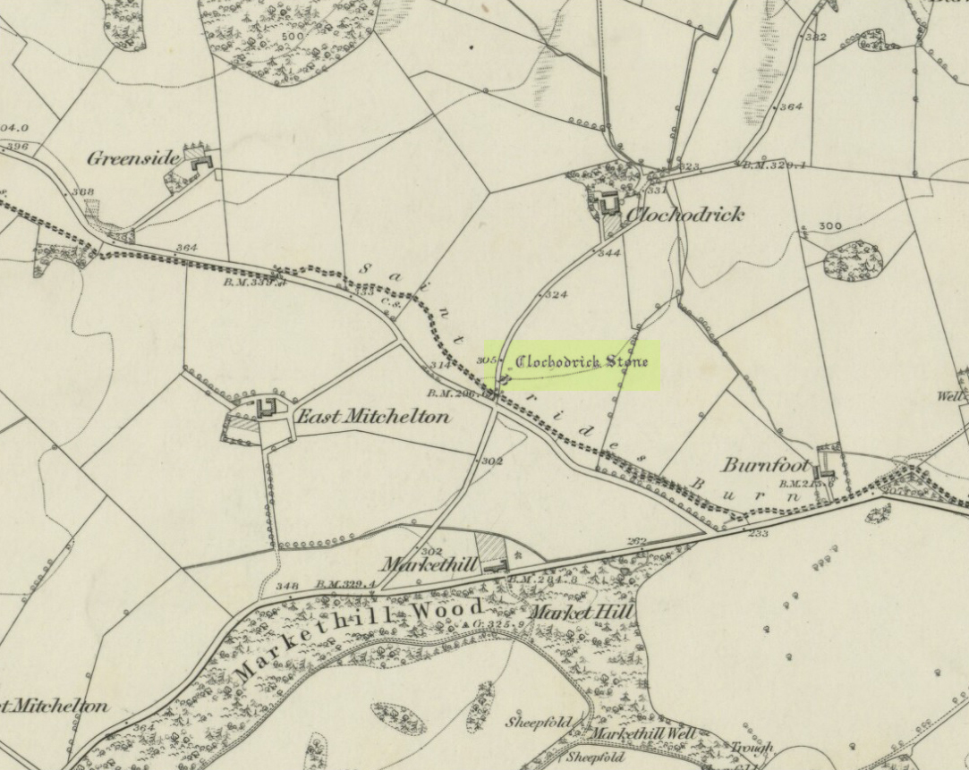
Clochoderick Stone on 1857 map
The site was highlighted on the first OS-map of the area in 1857, but the earliest mention of it seems to be as far back as 1204 CE, where it was named as Clochrodric and variants on that title several times in the 13th century. It was suggested by the old place-name student, Sir H. Maxwell, to derive from ‘the Stone of Ryderch’, who was the ruler of Strathclyde in the 6th century. He may be right.
Folklore
Folklore told that this stone was not only the place where the druids held office and dispensed justice, but that it was also the burial-place of the Strathclyde King, Ryderch Hael.
References:
Campsie, Alison, “Scotland’s Mysterious Rocking Stones,” in The Scotsman, 17 August, 2017.
MacKenzie, Robert D., Kilbarchan: A Parish History, Alexander Gardner: Paisley 1902.
Acknowledgements: Big thanks to Frank Mercer for use of his photos and catalytic inception for this site profile.
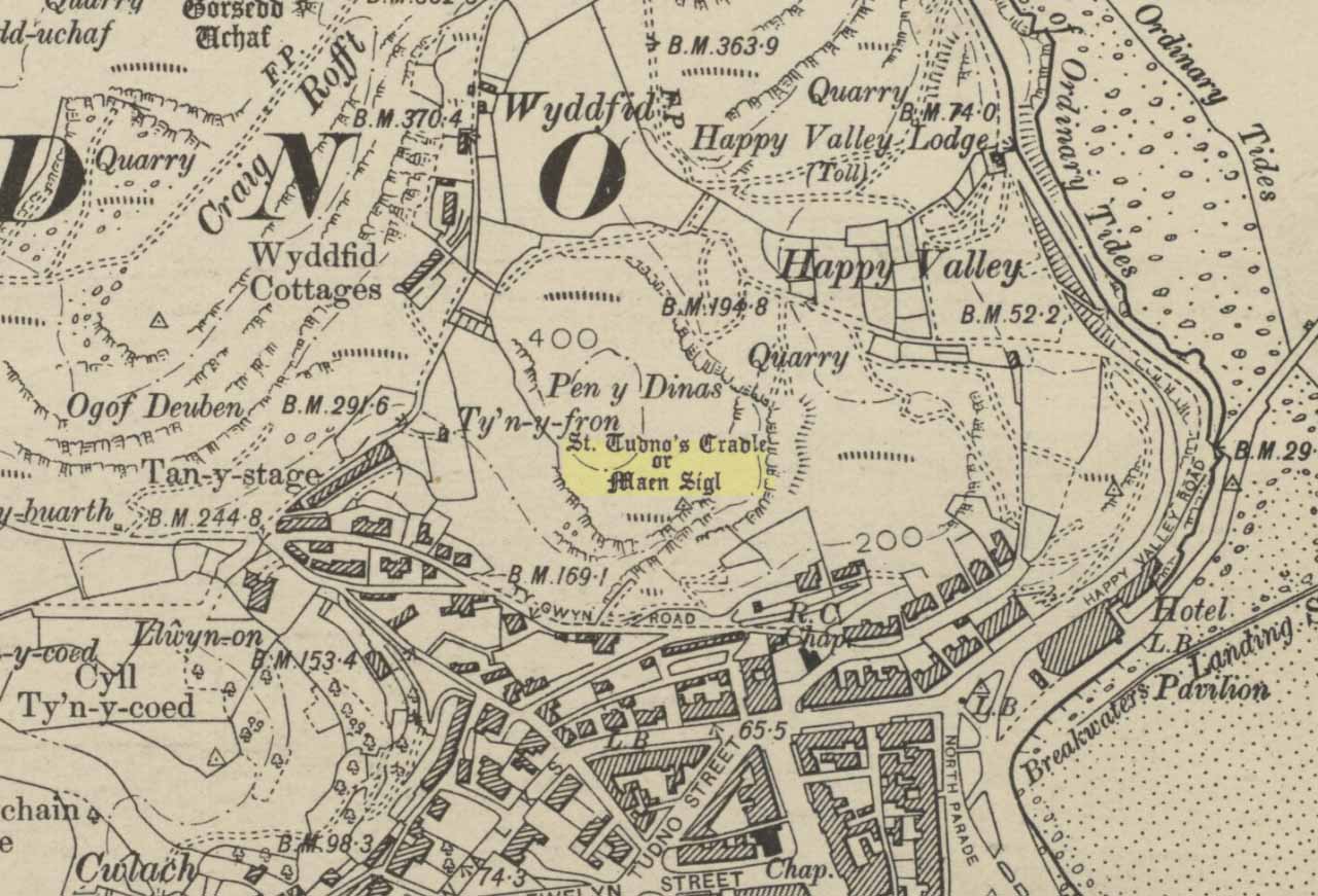
Highlighted on the 1901 OS-map of the area, this old rocking stone was located on the heights of Pen y Filas above Llandudno. Originally a site of heathen worship—the druids, it is said—the site was later patronised by the Irish saint, Tudno: a hermit who lived in a cave (Ogof Llech) a mile to the northwest, on the heights of the legend-filled Great Orme.
Rocking stones are well-known as geo-oracular forms (stone oracles) in folklore texts across the country, although they’re almost entirely rejected by historians as little more than ‘curiousities’ and meaningless geological formations. In olde cultures elsewhere in the world however, stones like this were always held in reverence by traditional people – much as they would have done in Wales and elsewhere in Britain.
References:
Hughes, Arthur R., The Great Orme: Its History and Traditions, R.E. Jones: Conway n.d. (c. 1950)
Jones, H. Clayton, “Welsh Place-Names in Llandudno and District” in Mountain Skylines and Place-Names in Llandudno and District, Modern Etchings: Llandudno n.d. (c.1950)
Legendary Rocks (destroyed): OS Grid Reference – NO 3813 5496
Archaeology & History
Like many rocking stones across the British Isles that were written about by early 18th and 19th century authors, the ones at Kirriemuir have fallen prey to the vandalism of those people (christians, Industrialists and other self-righteous fools) that has so blighted our heritage, and ancestral history, with an intolerance of indigenous beliefs and remarkable geological formations. But, I suppose, at least we have a record of them, which at least in some way gives us the ability to add further our knowledge of the traditional practices of our peasant ancestors and their perception of the landscape.
Rocking stones shown on 1865 6-inch OS-mapRocking stones shown on 1865 25-inch OS-map
The exact location of the legendary rocks were highlighted on early Ordnance Survey maps, thankfully; and there were in fact two rocking stones here, very close to each other by the sound of it. Mentioned only in passing by E.S. Valentine (1912), the place was best described in A.J. Warden’s (1884) massive history work on the region. He told that:
“On the top of the Hillhead, Kirriemuir, there were two fine specimens of these interesting memorials, upon which the dwellers in the district looked with wonder and awe. These time honoured monuments of a long past age were, in 1843, blasted with gunpowder, and the shattered pieces used in building dykes and forming drains, to the deep regret of antiquarians, and of the inhabitants of the district. …These stone memorials of a remote age are thus described by the Rev., T. Easton, D.D., in the new Statistical Account of the parish — ‘The one of them is a block of whinstone, nearly oval, and is three feet three inches in height, and four feet ten inches in breadth. The other, of Lintrathen porphyry, is two feet in height, eight feet in length, and five feet in breadth.’ He gives no description of the bases upon which the magic pivots moved, or other details of them.”
About a half-mile east you would have looked across at the large standing stone on Kirriemuir Hill, which legend asserts was once a stone circle (it too, destroyed). If anyone has any further information about these old stones, please let us know…
References:
Valentine, E.S., Forfarshire, Cambridge University Press 1912.
Warden, Alex J., Angus or Forfarshire: The Land and People – Descriptive and Historical – volumes 1 & 4, Charles Alexander: Dundee 1880-1884.
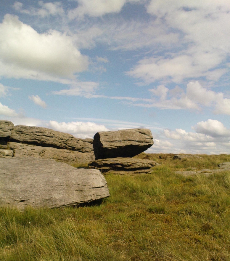
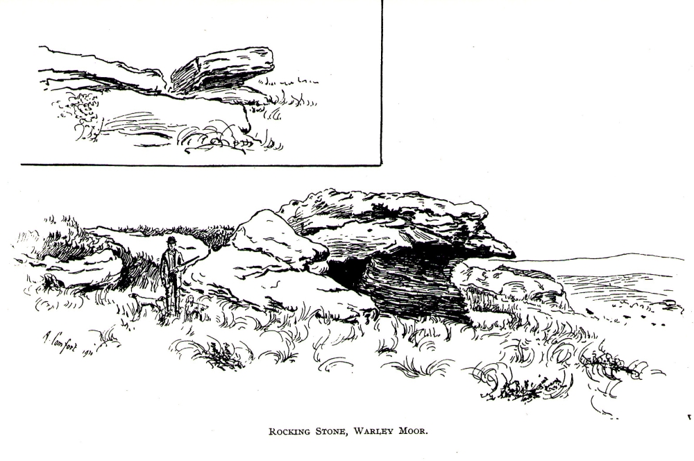
From Denholme, take the A6033 Hebden Bridge road up, but shortly past the great bend turn off right up the steep road towards the moorland windmills until you reach the flat dirt-tracked road, past the reservoir below. A coupla hundred yards past the track to the reservoir, take the footpath south into the tribbly grasslands and moor. A few hundred yards down you’ll note the large rock outcrop ahead of you. The rocking stone is there!
Archaeology & History
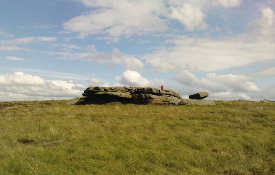
The old rocking stone
A small moorland arena with a neglected history. Many lost memories surround this site, with barely legible ruins from medieval and Victorian periods prevailing against scanty snippets of neolithic and Bronze Age rumours and remains. The rocking stone here—which moves slightly with a bit of effort—sits amidst a gathering of other large rocks, some of which have debatable cup-markings on their smoothly eroded surfaces.
Our rocking stone, resting 1350 feet (411m) above seal level, was first mentioned in John Watson’s (1775) magnum opus, who gave a quite lengthy description of the site, telling us that,
“On a common called Saltonstall-moor, is what the country people call the Rocking-stone… The height of this on the west side (which is the highest) is, as I remember, about three yards and a half. It is a large piece of rock, one end of which rests on several stones, between two of which is a pebble of a different grit, seemingly put there for a support, and so placed that it could not possibly be taken out without breaking, or removing the rocks, so that in all probability they have been laid together by art. It ought to be observed, that the stone in question, from the form and position of it, could never be a rocking stone, though it is always distinguished by that name. The true rocking stone appeared to me to lie a small distance from it, thrown off its centre. The other part of this stone is laid upon a kind of pedestal, broad at the bottom, but narrow in the middle; and round this pedestal is a passage which, from every appearance, seems to have been formed by art, but for what purpose is the question.”
Dubious cupsWatson’s 1775 drawing of the Rocking Stone
Watson then goes onto remark about other rocking stones in Cornwall and further afield with attendant “druid basins” on them, noting that there were also “rock basins” found here on Warley Moor, a few of which had been “worked into this rocking stone,” which he thought, “helps to prove that the Druids used it.” And although these rock basins are large and numerous over several of the rocks on this plateau, like the cup-markings that also scatter the surfaces, they would seem to be Nature’s handiwork.
Turner’s 1913 drawing
Some 60 years later when the literary thief John Crabtree (1836) plagiarized Watson’s words verbatim into his much lesser tome, it seemed obvious he’d never ventured to explore the site. But in the much more valuable historical expansion written by John Leyland around 1867, he at least visited the site and found the old stone, “still resting on its shady pedestal.” Later still, when Whiteley Turner (1913) ventured this way on one of his moorland bimbles, he added nothing more to the mythic history of these west-facing megaliths…
Folklore
Still reputed locally to have been a site used by the druids; a local newspaper account in the 1970s also told how local people thought this place to be “haunted by goblins.”
References:
Bennett, Paul, The Old Stones of Elmet, Capall Bann: Milverton 2001.
Crabtree, John, Concise History of the Parish and Vicarage of Halifax, Hartley & Walker: Halifax 1836.
Leyland, F.A., The History and Antiquities of the Parish of Halifax, by the Reverend John Watson, M.A., R.Leyland: Halifax n.d. (c.1867).
Smith, A.H., The Place-Names of the West Riding of Yorkshire – volume 3, Cambridge University Press 1961.
Turner, Whiteley, A Spring-Time Saunter round and about Bronte Lane, Halifax Courier 1913.
Watson, John, The History and Antiquities of the Parish of Halifax, T. Lowndes: London 1775.
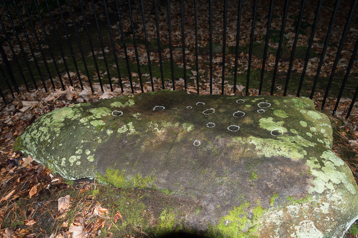
Come out of Ilkley/bus train station and turn right for less than 50 yards, heading left up towards White Wells. Go up here for less than 100 yards, taking your first right and walk 300 yards up Queens Road until you reach the St. Margaret’s church on the left-hand side. On the other side of the road, surrounded by trees is a small enclosed bit with spiky railings with Panorama Stones 227, 228 and 229 all therein: the least-decorated one on the left being the one we’re dealing with here.
Archaeology & History
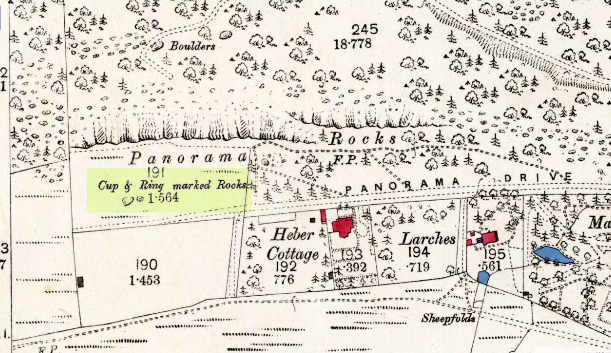
This is another of the caged Panorama Stones, found within the awful spiked fencing across from St. Margaret’s Church, just out of Ilkley centre. Originally located ¾-miles (1.2km) WSW of its present position in Panorama Woods (at SE 10272 46995), along with its petroglyphic compatriots in this cage, the carving was moved here in 1890 when a Dr. Little—medical officer at Ben Rhydding Hydro—bought the stones for £10 from the owner of the land at Panorama Rocks, as the area in which the stones lived was due to be vandalized and destroyed. Thankfully the said Dr Little was thoughtful and as a result of his payment he had some of the stones saved and moved into their present position.
Original location of stonesJ.T Dale’s 1879 sketch
It was first described by the northern antiquarian and petroglyph pioneer, J. Romilly Allen (1879) , who saw it in the now-destroyed “rough inclosure”, as he called it, along with the other stones now in the same Ilkley ‘cage’. Its present position does it no justice whatsoever in terms of its original position. It was ostensibly a rocking stone: this seemingly trivial-looking boulder was sat on top of the much-cropped Panorama Stone 228 (a yard east of the three in this outdoor cage). Allen (1879) was fortunate enough to have seen the stone before it was uprooted, telling us how this topmost stone, “has eleven cups, wo of which are surrounded by single rings.” The modern archaeologist John Hedges (1986) told it to be in a “bad state,” with “very worn carvings, fourteen cups, one with partial ring and groove.” Its situation deteriorated further, as stated by rock art students Boughey & Vickerman (2003), who noted,
“medium-sized, roughly triangular rock, its surface recorded as in a bad state in 1986 and now (2002) even worse. Fourteen cups, one with partial ring, one groove.”
And its condition isn’t helped by its inaccessibility, when groups like the ‘Friends of Ilkley Moor’ or the local archaeologist should be at least annually cleaning this and the adjacent carvings. If they’re incapable, there are sincere people in antiquarian, history and pagan groups who would probably help out…
John Hedges 1986 sketchFaint cupmarks visible
In truth, this carving cannot be seen in isolation, nor merely reduced to a numeric catalogue in some rock art corpus. We must contextualize its relationship with the once much-larger multiple cup-and-ring stone on which it sat and then see it as it was in the landscape. Originally of course the rocking stone was Nature’s very own creation. As humans began migrating over and eventually occupying this once-wooded arena, the rocking stone became intimately related with animistic magickal rites and, over time, petroglyphs began to be etched upon the stone. Most probably the flat underlying rock surface was carved upon first, and a symbiotic relationship was forged between Earth’s surface and the small rocking stone, both of which were used in oracular and other rites. Over centuries, as the cups and rings on the earthfast stone grew, the mythic status of this small rocking stone allowed for the encroachment of carvings, and eventually cup-marks began to be etched upon it too. Later still, as the neolithic period moved into the Bronze Age, the people began to build a low-walled stone enclosure around this and the nearby multiple-ringed carving – similar to the multi-period enclosure at Woofa Bank and other sites on these moors. It was all a very long and gradual process.
In truth, the mythic status of this once-impressive site would have been maintained—in one form or other—well into the medieval period. But that’s another matter altogether…
Bennett, Paul, The Panorama Stones, Ilkley, TNA: Yorkshire 2012.
Bennett, Paul, Aboriginal Rock Carvings of Ilkley and District, forthcoming.
Boughey, Keith & Vickerman, E.A., Prehistoric Rock Art of the West Riding, WYAS: Leeds 2003.
Cowling, Eric T., Rombald’s Way, William Walker: Otley 1946.
Downer, A.C., “Yorkshire Archaeological and Topographical Association,” in Leeds Mercury, August 28, 1884.
Eliade, Mircea, The Sacred and the Profane: The Nature of Religion, Harcourt, Brace & World: New York 1959.
Hadingham, Evan, Ancient Carvings in Britain, Souvenir Press: London 1974.
Hedges, John, The Carved Rocks on Rombald’s Moor, WYMCC: Wakefield 1986.
Heywood, Nathan, “The Cup and Ring Stones of the Panorama Rocks”, in Transactions Lancashire & Cheshire Antiquarian Society, Manchester 1889.
Speight, Harry, Upper Wharfedale, Elliott Stock: London 1900.
Acknowledgements: With huge thanks to both Dr Stefan Maeder for help in cleaning up the stones; and to James Elkington for allowing use of his photos in this site profile.
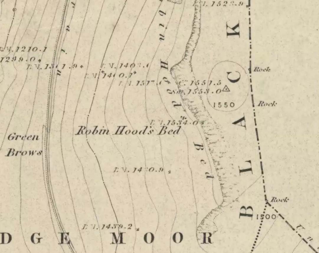
Follow the same directions to get to the Aiggin Stone. Once here, go over the stile by the fence opposite towards the great geological ridge less than half-a-mile south. Head for the triangulation pillar right on the top of the ridge, and there, about 20 yards past it, higher-up than the triangulation pillar at the very top of Blackstone Edge, is Robin Hood’s legendary stone bed!
Archaeology & History
Robin Hoods Bed, looking north
There’s very little of archaeological interest known up here, save a mass of flints and scrapers that have been found scattering the moorland heights hereby, from the mesolithic period onwards. But we have a relative lack of neolithic to Iron Age remains — officially anyhow! A possible standing stone can be found a few hundred yards south, but there’s little else.
The rock that’s given its name to Robin Hood’s Bed overlooks the very edge of the ridge, detached from the main section, with a large and very curious nature-worn ‘bed’ on its very crown, more than 4 feet wide and about 7 feet long, into which one comfortably lays. It was named in the boundary records of the township of Rishworth in 1836, where it describes other historical stones, saying:
“thence under Robin Hood’s Bed to a stone marked ‘W.S.G.S. 1742, 1770, 1792, and the following figures and letters, ‘1826 I.L.S.'”
Folklore
This enormous millstone grit boulder, sitting 1550 feet upon the high moors is, according to legend, a place where our famous legendary outlaw once slept. Whilst sleeping here, some of his followers were said to have kept guard and looked over him.
Robin Hood’s Bed, from below
A rather odd piece of folklore recited by Jessica Lofthouse (1976) is that “no winds ever blow” at Robin Hood’s Bed, who then went on to tell of the time she visited the place. Walking along the rocky ridge where the stone bed is found, the winds were such that “we had almost been blown over the edge,” until just a few hundred yards further when they eventually reached the fabled site, Nature granted them a sudden calmness unknown to all the high moorlands around, affirming the curious folklore.
The ceremonial stone ‘bed’
Robin Hood’s Bed itself was undeniably an important ceremonial site for both rites of passage and ritual magick to our indigenous ancestors. The place screams of it! It also seems very likely that the hero figure of Robin Hood replaced an earlier mythological character, akin to the fabled female creation deity, the cailleach, found commonly in more northern and Irish climes, whose echoes can still be found around our Pennine hills. For we find that Robin Hood was said to have taken a large boulder from here and with a mighty heave threw it six miles across the landscape due west into the setting sun, where it eventually landed at Monstone Edge, near Rochdale! Local people were so astounded at this feat that the stone was given the name of Robin Hood’s Quoit.
7ft tall natural standing stone
The old place-name authority Eilert Ekwall (1922) related the folklore that the giant ridge of Blackstone Edge “is said to refer to a boundary stone between Yorkshire and Lancashire.” Which may be the curious upright standing stone, more than 7 feet tall, less than 50 yards NNE which gives a very distinct impression of having been deliberately stood upright, amidst this mass of loose geological droppings! It would be helpful if there was a geologist in the house who could tell us decisively one way or the other…
Another etymological possibility that has been posited relates to the word ‘bed’ at this site. Ordinarily it would be sensible to attach the word to the great stone ‘bed’ atop of the poised boulder. But with the attached legends symptomatic of prehistoric monuments, it would not be improper to highlight that the old Welsh word ‘bedd‘ (a place-name element that is not uncommon in Lancashire) means, “a grave or tomb”. And this site would be ideal for such an old prehistoric cairn…
References:
Bennett, Paul, The Old Stones of Elmet, Capall Bann: Milverton 2001.
Ekwall, E., The Place-Names of Lancashire, Manchester University Press 1922.
Lofthouse, Jessica, North Country Folklore, Hale: London 1976.
Smith, A.H., The Place-Names of the West Riding of Yorkshire – volume 3, Cambridge University Press 1961.
Legendary Rock (destroyed): OS Grid Reference – SE 0728 0944
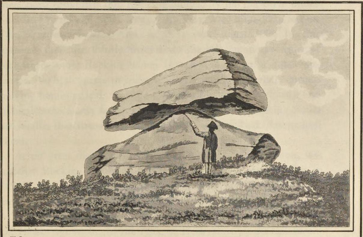
Archaeology & History
The Rocking Stone in 1720
Here we have the case of yet another rocking stone destroyed by a bunch of morons in bygone days. Although marked on the first Ordnance Survey of the region around 1850, the site had already been destroyed by then — but at least the surveyors had recorded its position in the landscape. And a dramatic and barren landscape it sat within!
It could be found high up in the middle of the moors above Brow Grains by the Wicken Stones, nearly 1400 feet above sea level, heading towards West Nab, and had lived here, safely, for untold thousands of years. But then, on Whitsun Monday morning in either 1827 or 1828, there came, wrote Joseph Hughes (1866),
“some half-dozen masons (who) planned and executed the work of destruction for a frolic. They first endeavoured to accomplish it by blasting it with gunpowder and, on the failure of this scheme, they fetched tools from Deer Hill, with which they drilled a hole and then wedged it, when the stone fell with a tremendous crash, hardly allowing the man on its summit who was drawing in the wedge to escape without injury.”
It’s a huge pity that the boulder didn’t crush him to death for his actions. At least it would have taught the halfwits a lesson (forgive me if I sound a bit harsh – but I have an increasingly lower opinion of selfish humans the older I get). Thankfully though, one hundred years before the stone was destroyed, Mr John Warburton of the Somerset Herald visited the region in 1720 and on one of the days here, took a long walk up to the Rocking Stone, from where we have this rare old drawing of the site. As Mr Ahier (1942) told us,
“His sketch plainly shows one stone superimposed upon another, and it is conceivable that the uppermost stone could be rocked on the lower one.”
There was also another Rocking Stone in the locale, it too destroyed, this time “by a former gamekeeper” no less, using the time-honoured excuse:
“because persons going to see it crossed the moor, and, in doing so during the nesting season, were liable to tread on eggs or upon young birds.”
This excuse is an even poorer one these days (as any honest ranger will tell you – which includes me in my former capacity as an assistant moorland ranger), as walking the moors causes much less damage than the moorland “management” of draining the bogs, dyke cutting, grouse-shooting, bracken control, letting the Snoots drive their vehicles over the heathlands, upgrading modern footpaths, etc. (God – I’m on a rant!)
References:
Ahier, Philip, The Legends and Traditions of Huddersfield and District, Advertiser Press: Huddersfield 1942.
Hughes, Joesph, The History of the Township of Meltham, John Russell Smith: London 1866.
Legendary Rock (destroyed): OS Grid Reference – SE 076 163
Also Known as:
Holed Stone
Holy Stone
Whole Stone
Archaeology & History
Golcar rocking stone, 1799
Like many old rocking stones, this was destroyed due to quarrying operations many years ago and sadly, I believe, we have no illustrations of the place to show the site. This legendary site—also known as the ‘Holed’ or ‘Holy Stone’—is preserved in the place-name of Rocking Stone Hill and, unlike many other alleged rocking stones, actually swayed to and fro if the old records are owt to go by. Not far away (and also destroyed some 200 years back) were two stone circles which probably had some mythic relationship to this legendary rock.
The stone was first described by John Watson in his monumental History of Halifax (1775), where he told that is was,
“so situated as to be a boundary mark, dividing the two townships of Golcar and Slaightwait in the Parish of Huddersfield, adjoining to the Parish of Halifax on Wholestone Moor. The stone as measured by the late Thomas Perceval, or Royton…is 10½ feet long, 9ft 4in or 5in broad, and 5ft 3in thick. Its weight…is 18 tons, 190lbs. It rests on so small a centre, that at one particular point, a man may cause it to rock; though some years ago it was damaged a little, in this respect, by some masons, who endeavoured, but in vain, to throw it off its centre, in order to discover the principle on which so large a weight was made to move.”
Mr John Crabtree (1836) included it in his survey, and it was illustrated on the very first Ordnance Survey map in the 1840s where it was described as ‘Supposed Druidical’. But the old stone sadly didn’t last much longer. Once the self-righteous Industrialists got here, round about the year 1886, the Rocking Stone was destroyed by quarrying operations. All that remains of the place today is a small cluster of place-names..
Folklore
Thought by Watson (1775) and his contemporaries to have had druidic associations (without evidence), when Philip Ahier (1942) came exploring this area in 1936, he came upon “an old resident (who) informed me that he had sat upon the stone when a youth and had caused it to rock.”
References:
Ahier, Philip, The Legends and Traditions of Huddersfield and District, Advertiser Press: Huddersfield 1942.
Bennett, Paul, The Old Stones of Elmet, Capall Bann: Milverton 2001.
Crabtree, John, Concise History of the Parish & Vicarage of Halifax, Hartley & Walker: Halifax 1836.
Watson, John, The History and Antiquities of the Parish of Halifax, T. Lowndes: London 1775.