Cup-Marked Stone (removed): OS Grid Reference – SE 1579 3995
Archaeology & History
Jenny Lane carving
A small, seemingly broken cup-marked stone that may have once been part of a prehistoric tomb, found itself being included in an old wall at some time in the not-too-distant past: in the south-facing wall of the cricket ground at the top end of town. No one seemed to know it was there until it was noticed in the 1950s by a local man who brought it to the attention of Sidney Jackson (1958), editor of the local Bradford archaeology mag at the time. Jackson visited the site and thankfully did a sketch of what it looked like, before it was removed at a later date. He wrote:
“The small rectangular stone bearing four cup-shaped hollows…is another of Mr George Pritchard’s finds. It forms part of the high wall which bounds the Baildon Cricket Club’s ground in Jenny Lane… Its appearance suggests that it is part of a Bronze age cup-marked rock which was split to make building stones.”
Following its removal more than twenty years ago, it ended up in the hands of a dude from Cononley called Gerald Wright. I’m not sure whether it still lives over there or has subsequently found a new abode. Does anyone know what’s become of it…?
Folklore
Although there’s nothing specific to this carving, the place where it was found, on Jenny Lane, was where a phantom black dog used to be seen in bygone years. It was renowned as the harbinger od death.
References:
Jackson, Sidney, “Cup-Marked Stone in Jenny Lane, Baildon,” in Cartwright Hall Archaeology Group Bulletin, volume 3, part 10, 1958.
Sacred Well (destroyed): OS Grid Reference – SE 1589 3132
Archaeology & History
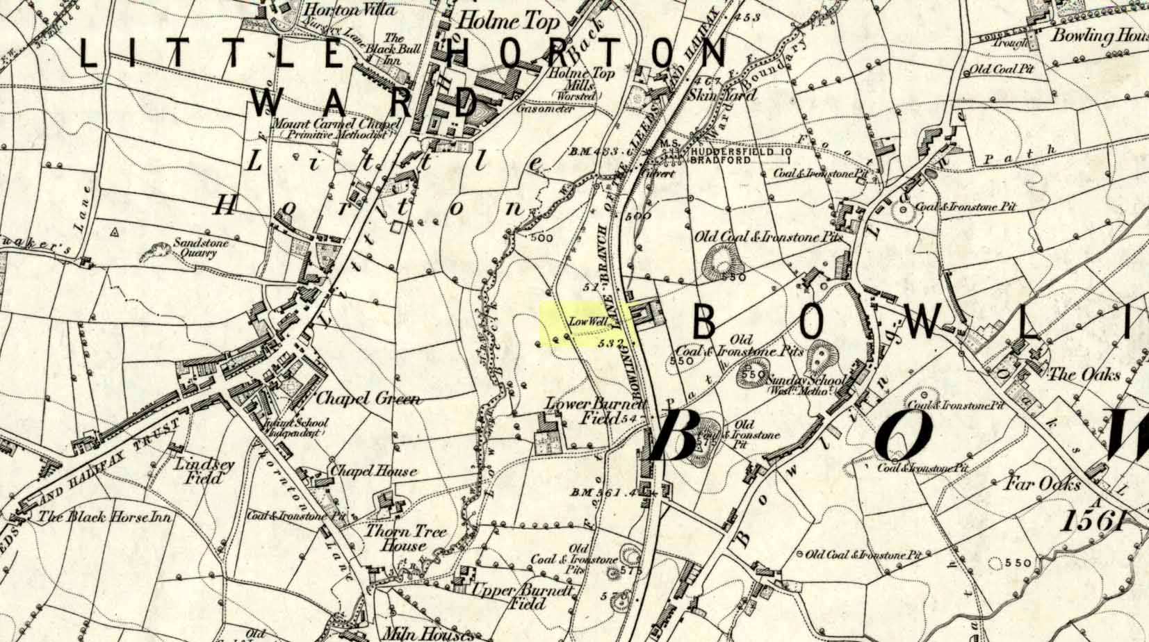
Low Well on 1852 map
Along the now-lost Low Well Road between Little Horton and West Bowling, could once be found this innocuous-sounding water source. Shown on the 1st OS-map of the area in 1852, the site was deemed to be little other than a ‘public well’. At the end of the 19th century, a small well-house was built over the waters; and the years following that saw its complete demise. Its name you would think relates to a position in the land, but the dialect word low, or lowe can mean “a flame, blaze, light, glow”, it can also refer to a prehistoric tomb. However in this case it most likely derives from “a pond or standing pool”.
…And if some of you wonder why I have given this so-called Public Well the provenance of being a “sacred well”, please keep reading…
Folklore
Although it was deemed a simple ‘public well’ by historians and the public water authority, local folk knew there was much more to it than that! In the Bradford area, this innocuously-named Well is the most promiscuously supernatural of all water sources, with a hidden history of magickians, ghosts and black dogs haunting its once ancient flow. It was a site remembered as having oracular powers, where local people used it in scrying the future. For such powers to work here, one had to gaze into the waters as they stilled at 6 o’ clock in the morning – a common time used by ritual magickians for the invocations of spirits.
The Bradford historian William Scrotum (1889) told us that in the 1860s, local people reported that the phantom black dog—or Bharguest as it was known—with its glowing red eyes, was seen coming out of the well after dark and scaring people half out of their wits. Very soon people would not even venture out after dark for fear of encountering this great harbinger of Death. Several years passed before local people called upon the abilities of a ritual magickian in the hope that he could lay the ghostly hound and bring peace and stability back to the hearts and minds of those living hereabouts. Eventually, after much work, the magickian exorcised the waters and cast the black dog back into the depths of the Earth from whence it had come and, to this day, sightings of the spectral hound have stopped.
Water sources that possess ingredients of hauntings, magic and oracular properties are universally ascribed as ‘sacred’ in one way or the other. In pre-industrial times I have little doubt that, amongst the animistic pantheon of local Bradfordians, this was no exception.
References:
Scruton, William, Pen and Pencil Pictures of Old Bradford, Thomas Brear: Bradford 1889.
Wright, Joseph, The English Dialect Dictionary – volume 3, Henry Frowde: London 1902.
Holy Well (destroyed): OS Grid Reference – SE 1609 3961
Archaeology & History
This site is all but unknown to the great majority of folk in Baildon, and even some of the local historians have let it slip from their investigative tendrils. According to the primary Baildon historian, W.Paley Baildon, it was first known as the ‘Halliwell Holy Well’. In his magnum opus (1913-26) of the township he relates that,
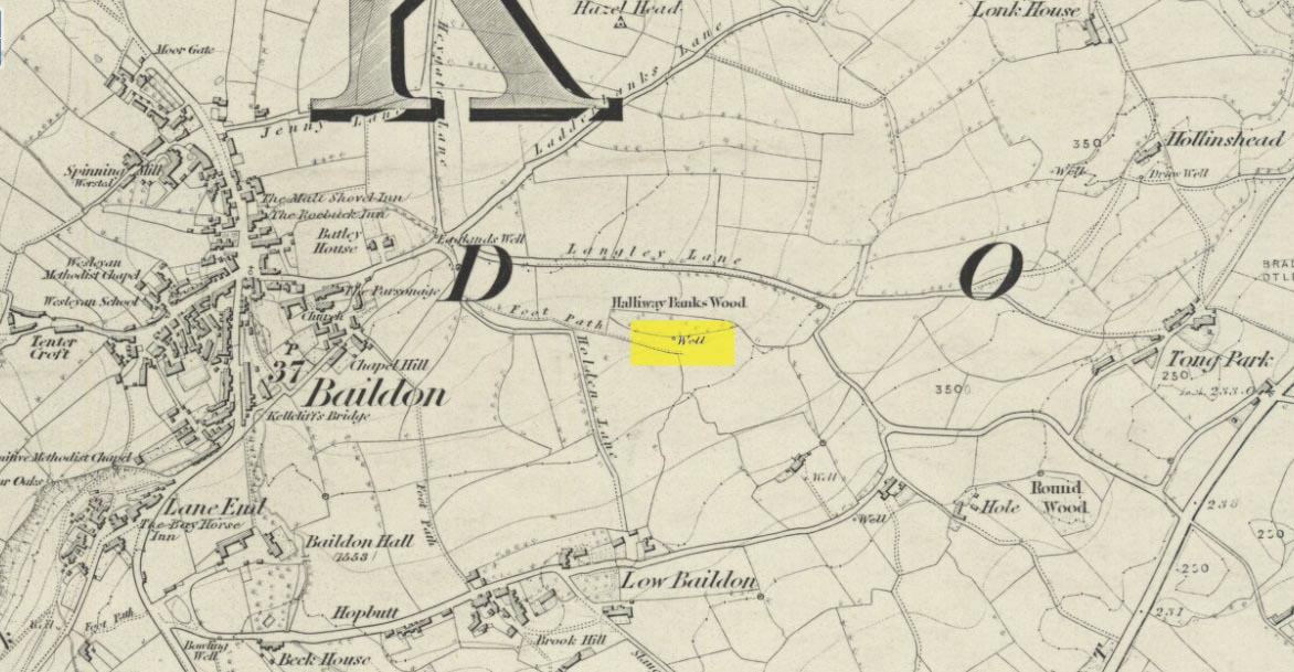
“The 1852 Ordnance map marks Halliway Banks Wood to the south of Langley Lane, with a well just below it, and a footpath from Holden Lane to the well. Halliway, I think, is a corruption of Halliwell, the ‘holy well,’ with the special footpath leading to it and nowhere else. Haliwell Bank occurs in (the Baildon Court Rolls of) 1490, when it formed part of the property held by William Tong of Nicolas Fitz William.”
This etymology is echoed by the great place-name authority A.H. Smith (1954). It also caught the attention of archaeologist Andrea Smith (1982), in her investigation of twenty-five holy wells in the West Yorkshire region.
“Many wells,” she wrote, “are recorded simply as ‘Holy Well,’ or the various forms ‘Halliwell,’ ‘Helliwell’ and ‘Hollowell.’ It is possible that in these instances the identity of the patron saint or guardian of the well has been forgotten, which may be the case with the site at Collingham, now known as Hollowell.”
Site of the Holy Well in 1852
The well itself can no longer be seen. When I looked for the site in 1982, I found that to the right of where the 1852 map showed it, was a waterworks lid covering the old holy waters, just in the trees atop of the field beneath a great sycamore with a number of small stones roughly encircling the site: perhaps the only possible relics of the century before when the waters would have been used. A stone trough was situated at the bottom of Holden Lane, fed by the waters from the Halliwell and from here the course of the stream meandered down the side of Slaughter Lane, now known as Kirklands Road. The land around Halliwell became known as Kirkfield, or field of worship.
A local resident told how during autumn and winter, the left side of the field gets extremely boggy – the region were the old stream ran from the old well, along which dowsers have found aquastats abound. Now however, houses have been built where the waterworks-lid used to be and is likely to be in someone’s backyard, all but forgotten.
Folklore
According to local lore, the site of this most ancient of holy wells was found in the warmest place in the Baildon district. Whilst its geographical position doesn’t necessarily suggest this (although it did face south, into the sun), this lore may reflect some healing aspect of the well that has long since been forgotten.
Perhaps relevant to Andrea Smith’s comment about there being ‘guardians’ at holy wells is found in folklore relating to nearby Holden Lane: locals in the last century also referred to it as Boggart Lane, so called after the Boggart which was seen there in the form of a spectral hound that was said to possess large glowing red eyes and was a sign of ill omen. Modern sightings of the spectral hound, which appeared along the road which led to the old well, are unknown.
References:
Baildon, W. Paley, Baildon and the Baildons (parts 1-15), St. Catherines: Adelphi 1913-26.
Smith, A.H., English Place-Name Elements – volume 1, Cambridge University Press 1954.
Smith, Andrea, ‘Holy Wells Around Leeds, Bradford & Pontefract,’ in Wakefield Historical Journal 9, 1982.
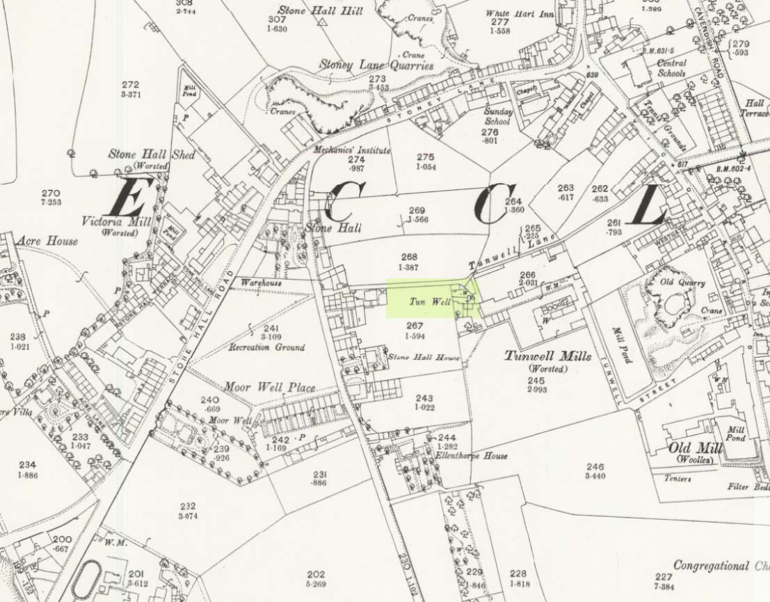
First mentioned in local history accounts from 1618—as the Tunwells—it was highlighted on the first OS-map of Eccleshill in 1851. Located on the aptly-named Tunwell Lane, it was a deep well covered by a large flat slab of stone, at the back-end the old Victorian mill. The stone was put there to prevent children falling into it. Some old locals thought the name of the place derived from a ‘tun’, or hundred, meaning it to be a hundred feet deep; although as A.H. Smith (1961) tells, tun could equally relate it to be one of Eccleshill’s town wells, of which there were several. It used to be one of the principal drinking supplies for the village and was said to rarely run dry. In William Ranger’s (1854) survey, he told this to be one of the sites to which local people relied in times of drought, where the land-owner allowed local folk to collect their supplies.
Folklore
The old cobbled Tunwell Lane was long ago supposed to be the haunt of a phantom black dog: a visionary precursor of death and Underworld guardian. Its spirit came and went into the deep well. I remember hearing tales of this when I was a young lad, as the old women who worked in the adjacent mills spoke of it. The ghost of a so-called ‘white lady’ was also said to walk along Tunwell Lane.
In more recent times, Val Shepherd (2002) included this in her short survey of wells in the area as being on “an alignment” with Eccleshill’s Moor Well and Holy Well. She thought “it may be part of a ley line”, but her alignment is inaccurate and doesn’t hit the spots.
References:
Crapp, H.C. & Whitehead, Thomas, History of the Congregational Church at Eccleshill, Watmoughs: Idle 1938.
Ranger, William, Report to the General Board of Health on a Preliminary Inquiry into the Sewerage, Drainage, and Supply of Water, and the Sanitary Condition of the Inhabitants of the Township of Eccleshill, George Eyre: London 1854.
Shepherd, Val, Holy Wells of West Yorkshire and the Dales, Lepus: Bradford 2002.
Smith, A.H., The Place-Names of the West Riding of Yorkshire – volume 3, Cambridge University Press 1961.
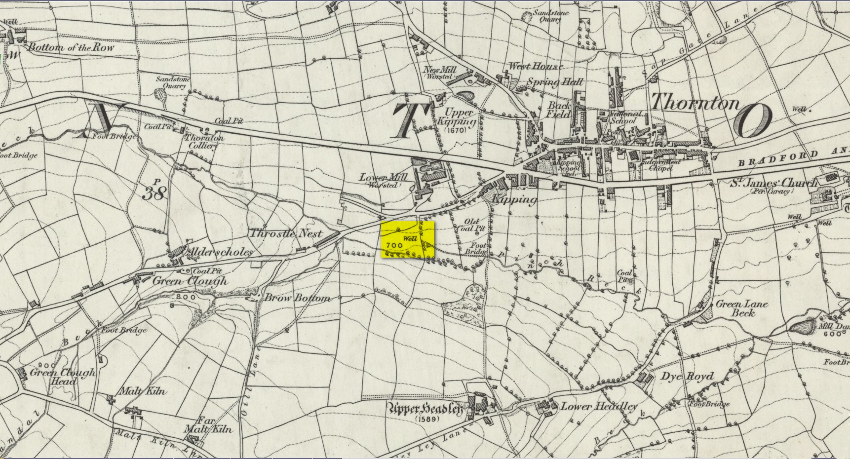
Another well with considerable supernatural renown was this little-known site near the old village of Thornton, on the western outskirts of Bradford. We’re not 100% sure about its exact location, but the grid-reference cited here is of an old ‘Well’ that was highlighted on the first Ordnance Survey map of the region, at the end of solitary path which led to it and nowhere else. Our only documentary information comes from Elizabeth’s Southwart’s (1932) fine old book on the folk life of the old village, as it once was. At a place once known as Bent Ing Bottom, just south of the old village, is where it used to be known. The name of this Well is also curious, as no historian has yet worked out who the ‘Jim Craven’ was, nor what his relationship to the site might have been. It’s the folklore of it, however, which brings it the attention it deserves.
Folklore
In Elizabeth Southwart’s (1923) work, she told us that the place once known as “Bent Ing Bottoms have lost their romance.” She continued:
“Whether the golfers have driven it away—for the fields now form part of the Thornton Golf Links—or whether the advance of modernity in other forms is to blame, it is difficult to say. Once they were the haunts of “Peggy-Wi-T’-Lantern” and the Bloody-tongue. Peggy, a dame in a white mob cap, kilted skirt and white stockings, walked about with a lantern, enticing the unwary traveller to his doom. She was given to wandering, for, they say, Jim Craven Well, half a mile away, was a place to be avoided after nightfall.
“The Bloody-tongue was a great dog, with staring red eyes, a tail as big as the branch of a tree, and a lolling tongue that dripped blood. When he drank from the beck (known as the Pinch Beck, PB) the water ran red right past the bridge, and away down—down—nearly to Bradford town. As soon as it was quite dark he would lope up the narrow flagged causeway to the cottage at the top of Bent Ing on the north side, give one deep bark, then the woman who lived there would come out and feed him. What he ate we never knew, but I can bear testimony to the delicious taste of the toffee she made.
“When the dark was coming we used to sit on the filled-in pit, which makes a hump in the middle of the field, and wait for him. The sun would sink redly, through the arches of the viaduct, the trees that lined the beck would grow an ever darker green until they became black, the beck would begin to gurgle and gulp in a queer way; and down in the hollow we would hear a whimper, a whine, a moan, a snarl. Then, with scalps and spines playing queer tricks, we would wait and wait. But none of our little band ever saw him, except one girl, and she saw him every time.
“One Saturday a girl who lived at Headley came to a birthday party in the village, and was persuaded to stay to the end by her friends, who promised to see her ‘a-gaiterds’ if she would. As soon as the party was over the brave little group started out. But when they reached the end of the passage which leads to the fields, and gazed into the black well, at the bottom of which lurked the Bloody-tongue, one of them suggested that Mary should go alone, and they would wait there to see if anything happened to her.
“Mary was reluctant, but had no choice in the matter, for go home she must. They waited, according to promise, listening to her footsteps on the path, and occasionally shouting into the darkness:
““Are you all right, Mary?”
““Ay!” would come the response.
“And well was it for Mary that the Gytrash had business elsewhere that night, for her friends confess now that at the first sound of a scream they would have fled back to lights and home.
“We wonder sometimes if the Booody-tongue were not better than his reputation, for he lived there many years and there was never a single case known of man, woman or child who got a bite from his teeth, or a scratch from his claws. Now he is gone, nobody knows whither, though there have been rumours that he has been seen wandering disconsolately along Egypt Road, whimpering quietly to himself, creeping into the shadows when a human being approached, and, when a lantern was flashed on him, giving one sad, reproachful glance from his red eyes before he vanished from sight.”
Southwart later tells us that the ghostly dog travelled into the north and vanished. From the description she gives of the children walking their friend to “the end of the passage which leads to the fields, and gazed into the black well, at the bottom of which lurked the Bloody-tongue,” I can only surmise that the solitary well shown on the very first OS-map of Thornton at the coordinate given above is the place in question.
The ‘Bloody Tongue’ is first mentioned in Yorkshire folklore, I think, by Roger Storrs, in his article on holy wells in 1888, where he tells it to be one of the mysterious beings that live, usually at the bottom of the waters and almost universally used “to deter children from playing in dangerous proximity to a well.”
From the description of the waters turning red when the ghostly dog drank from it, we have a mythic account of when the waters occasionally turned red from the iron-bearing waters (chalybeate) which, obviously, wasn’t like this at all times. Whether this was a sporadic, unpredictable flow of iron in the waters, or a cyclical pattern of the water-flows, we are not told (which would imply, moreso, that it was sporadic). The folklore about this ghost and its appearance with another elemental creature along an old straight track running north from Upper Headley Hall to Thornton is intriguing—as in many old pre-christian traditions, North is the airt, or direction, representing Death; and black dogs are traditionally guardians of underworld treasures in the land of the Dead. With the plethora of other animistic folktales once known in this district (boggarts or goblins were known in nearby woods, wells and farms) it is likely that the origin of such folklore dates way back into antiquity.
References:
Bennett, Paul, Ancient and Holy Wells of West Yorkshire, forthcoming
Southwart, Elizabeth, Bronte Moors and Villages: From Thornton to Haworth, John Lane Bodley Head: London 1923.
Storrs, Roger, ‘Legends and Traditions of Wells,’ in Yorkshire Folk-lore Journal – volume 1 (ed. J. Horsfall Turner) 1888.
Carlie Craig is the tree- covered cliff, centre of photo
If you’re coming from Blairlogie, a half-mile west of the village, take the B998 road to the university, but turn right up the first road that runs uphill into the trees. But if you’re coming from Stirling or Bridge of Allan, keep your eyes peeled for the barely visible B998 at the crossroads and go up the hill, and along, for a good mile, below the Uni, past the factory, then up the small road on your left. Up this road go past the church another 100 yards and you’ll see the derelict ruins of Logie Kirk on your right. Right above the ruin you’ll see the tree-lined cliff immediately behind. This is the Carlie Craig!
Folklore
Carlie Craig on the 1862 map
The tree-covered Carlie Crags above the old ruined church and graveyard of Logie Kirk immediately below (thought to have been built in 1684) has long been associated with legends of old witches. Deriving its name from ‘carlin’, a witch or old woman (cailleach), the Crags were traditionally the place of heathen rites (authentic ones, not your plastic pagan types). In David Morris’ (1935) essay on the local township, he told the common story that “an elder in Logie Kirk was of the opinion that the Carla’ Craig…was haunted.” At the end of the 19th century, Morris remembered a local lady known as ‘Ailie’, who was said by many old folk to be the traditional “witch of Logie.”
“Sickly children were brought to her for her blessing. Occasionally people came from as far as Stirling on this errand. Her method of giving the blessing was to blow her breath on the child, and this was supposed to ward off evil. It was also said that anyone buried in Logie Kirkyard on the first day of May, Hallowe’en, or other days of that kind, without her blessing, would not rest in his grave…”
Another legend told that,
“around 1720 witches were believed to rendezvous with the Evil One (i.e. the devil) who would appear in the form of a large black dog.”
A lengthier account of the belief in witchcraft and animistic pre-christian rites above the crags was told by Charles Rogers (1853):
“About the second decade of last century, there lived in the parish of Logie several ill-favoured old women, to whom the reputation of witchcraft was confidently attached. They were believed to hold nocturnal dialogues and midnight revels with the Evil One, and Carlie Crag was regarded as one of their places of rendezvous. Satan, though he was believed to appear to them in various forms, was understood, in his interviews with the dreaded sisterhood, to appear most frequently in the aspect of a large shaggy dog, in which form it was alleged he had repeatedly been seen by the minister. An elder of the kirk had been returning of an evening from a shooting excursion among the hills, with a trusty musket, which he had picked up some years before on the field of Sheriffmuir, and discovering on the top of Carlie an animal realizing the description of the Satanic mastiff, resolved to try upon it the effects of a shot. He knelt down cautiously near the foot of the crag, and after ejaculating a short prayer, and slipping into his musket a silver coin, fired with trembling heart but steady aim. His victim, evidently shot dead, tumbled to the base, and the delighted and astonished elder lost no time in personally communicating to the minister the success of his wonderful adventure. Though not a little superstitious, the minister was somewhat sceptical as to the mysterious dog being really dead. He however agreed to accompany his elder next morning to the foot of the crag to inspect the carcase; but on reaching the spot, they found the remains of no shaggy dog or evil genius, but the lifeless form of the beautiful pet goat of a poor and aged woman, a much respected parishioner. The minister and elder both shed tears. The wicked dog still lived, the innocent goat had perished. The elder however took credit to himself for his good intentions and valorous intrepidity ; and the minister deemed it proper to improve the subject in his pulpit prelections on the following Sabbath. Discoursing on the subject of resistance to the Devil, he remarked, that the Evil One might assume numerous shapes and forms; that he went about as a roaring lion was declared in the Word, but he might take to himself various other aspects. He might even appear as a black colley dog.” But whatever form he may assume,” added the minister, ” he cannot be overcome or destroyed by powder and shot. There is a gun, however, that will shoot him, and it is this — it is the Bible. Shoot him then, every one of you, with this gun, and he shall be shot.”
Whether the vicar’s biblical superstitions were adopted by local people—who were so much more used to the living animism of landscape and natural cycles—is questionable. The crag is a fine site for ritual magick and its associative devil-lore probably derives from Pictish shamanistic practices, remains of which are evident across the Scottish hillls and northern England, where they survived for some considerable time…
References:
Morris, David, B., “Causewayhead a Hundred Years Ago”, in Transactions of the Stirling Natural History and Archaeological Society, 1935.
Roger, Charles, A Week at Bridge of Allan, Adam & Charles Black: Edinburgh 1853.
Watson, Angus, The Ochils – Placenames, History, Tradition, Perth & Kinross District Libraries 1995.
Legendary Rocks (destroyed): OS Grid Reference – SE 187 545
Archaeology & History
The original position and nature of this site was difficult to ascertain and left us wondering whether the place was once a monolith, stone circle or legendary rock outcrop, as seemed that there were no remains left of the place. Aswell as that, the only reference we had that describing this place is from William Grainge’s History of Knaresborough (1871), where he wrote:
“At Busky Dike, a place between Cragg Hall and Fewston, according to the report of tradition, there once existed a Druidical altar; and that same venerable authority declares that the same place is the haunt of a Bharguest; and many of the country people yet tremble as they pass that place in the dark, for fear they should meet that strange and terrible beast.”
The latter remark would indicate that something decidely pre-christian was once of renown here. But it seems that an old rock outcrop was the place in question here, found in the now wooded area on the south side of the Busky Dike Road, just northwest a half-mile outside of Fewston itself. It would be good to hear more about this place…if anyone knows owt…
References:
Grainge, William, The History of Harrogate and the Forest of Knaresborough, 1871.
Grainge, William, The History and Topography of Little Timble, Great Timble and the Hamlet of Snowden, William Walker: Otley 1895.