Beckhampton Penning, Avebury, Wiltshire

Stone Circle (destroyed):  OS Grid Reference – SU 0986 6713

Archaeology & History

Smith’s plan of the site

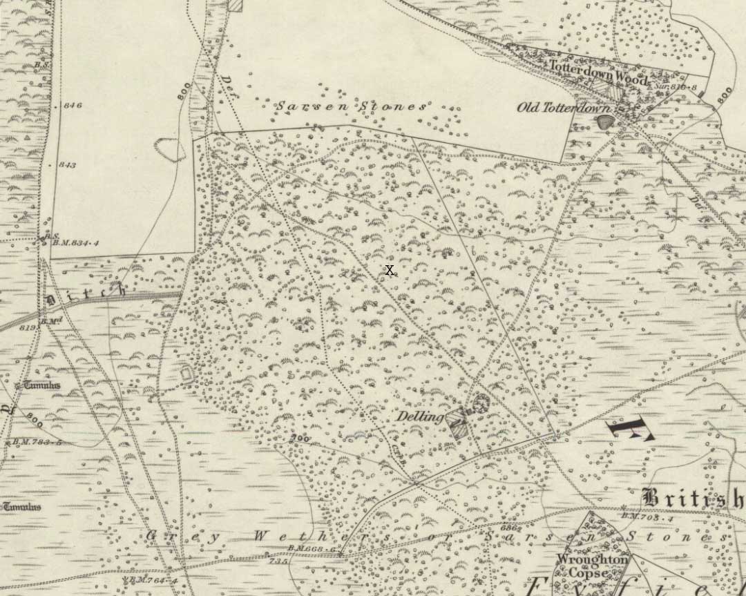
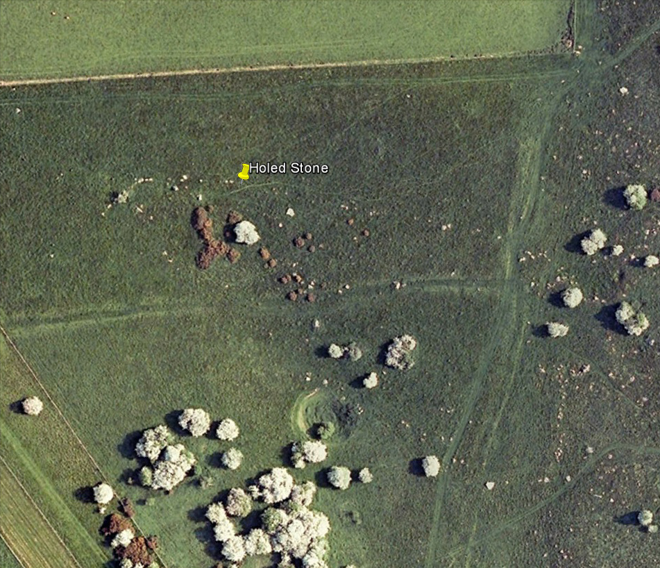
This all-but-destroyed megalithic ring is all-but-unknown in most of the archaeological gazetteers — including even Burl’s (2000) magnum opus!  But we know it was there.  And according to the Avebury authority Pete Glastonbury , there “are a couple or three small stones buried on the hill but nothing else to see.”  Which is a pity, as the site sounds like it was something to behold in bygone times.  Although it seems to have been described initially by the legendary druidical antiquarian, William Stukeley, a more lengthy description followed in the 19th century by the reverend A.C. Smith (1885), when he and a friend took it upon themselves to cut back some of the turf that was covering a number of stones — and they weren’t to be disappointed!

The site itself appears to have stood right on the southern boundary line of Avebury parish, meaning that the site could have been named and cited on any early boundary perambulation records that might exist of the parish. (do any of you Wiltshire folk have access to any such old records?)  But if there are no such early accounts, the earliest record we’ll have to stick with is good old Mr Stukeley (1743), who only gave it a passing mention, saying:

“Upon the heath south of Silbury was a very large oblong work like a long barrow, made only of stones pitch’d in the ground; no tumulus.  Mr Smith before-mentioned told me his cousin took the stones away (then) fourteen years ago, to make mere (boundary, PB) stones withal.  I take it to have been an Archdruid’s, tho’ humble, yet magnificent; being 350 feet or 200 cubits long.”

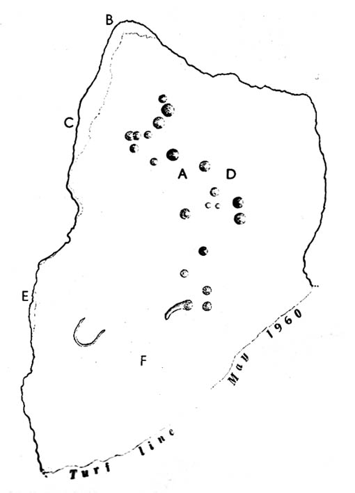
Nearly 150 years later Reverend Smith gave us a more detailed account, and ground-plan, describing the place as,

“a stone circle, of considerable dimensions, though imperfect and formed of very small sarsens, but which I believe to have been in some way connected with Abury.  Though it appears to have been mentioned by Stukeley one hundred and fifty years ago, it had been long since buried, and completely forgotten till I was fortunate enough to discover it by digging in the year 1877.  I was led to the discovery by the suspicious look of certain stones which, though scattered in no regular form, appeared as if they might have once stood erect, in some sort of order, on the segment of a large circle.  I had often stopped to examine them as I wandered over that part of the downs; till at last previous suspicions ripened into conviction, as closer observation revealed sundry other stones just showing above the ground, and there also seemed to be faint indications of a trench, all pointing, with more or less accuracy, to the supposed circle.  Not to dwell upon the details of the investigation, which, however, were of singular interest to me, the result was that (with the permission of both owner and occupier of the land, and assisted by Mr William Long), I probed the ground in every direction, and uncovered the turf wherever a stone was found: and on our first day’s work we unearthed no less than twenty-two sarsen stones, all forming part of the circle, and lying from two to twelve inches below the surface.  These stones were all of small size, some of them very small, but that they were placed by the hand of man in the positions they now occupy, in many cases nearly touching one another, and that they formed part of a large circle or oblong, admits, I think, of no doubt.  I say part of a circle, because, though the northern, southern and eastern segments are tolerably well defined, I could find scarcely a single stone on what should be the western segment to complete the circle.  That the area thus enclosed is not insignificant will appear from the diameter (in length, or from north to south, 261 feet; and in breadth, or from east to west, 216 feet).  Again, its position (due south of Silbury, and within full view of it, as well as the Sanctuary on Overton Hill, and with Abury immediately behind Silbury, due north of it, from which also Silbury is equidistant) seems to intimate that it may have had some connection with the great temple.”

A ley running through the circle (image courtesy Paul Devereux)

Smith then proceeded to query the nature of the monument, commenting on how Sir John Lubbock and members of the British Archaeological Association were intrigued by the remains, but a little perplexed and unable “to form any opinion” as to the exact nature of the site.  But this didn’t stop mythographer and historian Michael Dames (1977) who, in his classic Avebury Cycle, suggested that the site “marked the navel of the landscape goddess” in the region.

The site didn’t go unnoticed in Devereux and Thomson’s (1979) classic Ley Hunter’s Companion, where it plays an important point along a ley that runs north-south for 13 miles between Bincknoll Castle at the north, to Marden Henge at the south.  Such an alignment had been noted much earlier by other archaeologists and historians.

The site does look strange for a stone circle in Smith’s ground-plan and has more the hallmarks of a type of enclosure or settlement of some sort.  It certainly wouldn’t be out of place, design-wise, as a prehistoric settlement in our more northern climes.  However, without further data it seems we may never know the true nature of this old stone site…

References:

  1. Dames, Michael, The Avebury Cycle, Thames & Hudson: London 1977.
  2. Devereux, Paul & Thomson, Ian, The Ley Hunter’s Companion, Thames & Hudson: London 1979.
  3. Glastonbury, Pete, “Silbury ‘stone circle’ Query,” private comm., March 6, 2011.
  4. Smith, A.C., A Guide to the British and Roman Antiquities of the North Wiltshire Downs, Wiltshire Archaeological & Natural History Society 1885.
  5. Stukeley, William, Abury, A Temple of the British Druids, W. Innys & R. Manby: London 1743.

© Paul Bennett, The Northern Antiquarian


Broad Stones, Clatford, Wiltshire

Stone Circle (destroyed):  OS Grid Reference – SU 161 684

Also Known as:

  1. Clatford Stone Circle

Archaeology & History

John Aubrey’s early drawing (soz about the crap quality)

Also known as the Clatford Circle, it was described by both of the old pioneers, John Aubrey and William Stukeley: Aubrey saying the monument could be found “in a lane leading from Kennet to Marlborough… (consisting) of eight huge large stones, roughly hewn… in a circle, which never could be by chance.”  Will Stukeley reckoned that four other stones close by, “may possibly have been the beginning of an avenue.”  We might never know for sure.

The local Avebury authority, Pete Glastonbury, showed us a spot which he thinks may have been the where the circle stood, and where a couple of decent-looking stones lay by the side of the track that could have once been a part of this circle.  It looked as good a contender as anything else.  Has all trace of this monument truly been destroyed?

References:

  1. Burl, Aubrey, Prehistoric Avebury, Yale University Press 2002.

© Paul Bennett, The Northern Antiquarian


Devil’s Den, Clatford, Wiltshire

Cromlech:  OS Grid Reference – SU 15209 69651

Also Known as:

  1. Devils Den
  2. Dillion Dene

Getting Here

Devil’s Den, Wiltshire

When Pete Glastonbury brought us here, we walked east out of the Avebury stone circle and up the Wessex Ridgeway track.  When you hit the “crossroads” at the top of the rise a mile along, go across the stile into the grasslands for a few hundred yards till you hit the obviously-named “Gallops” racecourse-looking stretch.  Walk down for a few hundred yards till you hit a footpath on your left that takes you across and down grasslands that takes you slowly into the valley bottom.  You’re damn close!

Otherwise (and I aint done this route!), walk up the footpath straight north from Clatford village, up the small valley for about 1km.  You’ll eventually see this great stone heap in the field on your left!

Archaeology & History

I was brought here one fine day last year in the company of PeteG (our guide for the day), Geoff, June and Mikki Potts.  Twas a fine foray exploring the various prehistoric sites on the lands east of Avebury — but it was my very first venture to this site, the Devil’s Den — and a grand one it was indeed!  Standing close to the small valley bottom a couple of miles east of the great stone circle, this megalithic monument is thought to be neolithic in origin.

When H.J. Massingham (1926) came here, the day and spirit of the place must have felt fine, as he described,

“its three uprights and capstone stand forlornly in the midst of an alien sea of ploughland swinging its umber ripples to the foot of a stone isle, drifted nearly four thousand years from the happy potencies of its past.”

And, on many good times here no doubt, for many people, such feelings still hold…

A.C. Smith’s Devil’s Den
Colt Hoare’s Devil’s Den

It was described by the President for the Council of British Archaeology, Paul Thomas (1976), “as a setting of four sarsen uprights with a capstone”, whereby four uprights have not been noticed here since very early times.  Not sure how old he was though!  Today the very large capstone weighing upwards of 20 tons rests gently upon just two very bulky upright monoliths.  A third is laid amidst the great tomb , overgrown and sleepy, touching one of the two uprights….

The cromlech itself seems to have once been part of a lengthy mound that was covered in earth, “about 230ft long and 120ft broad, now virtually removed by ploughing.”  On top of the great capstone are at least two cup-markings: one of them with a possible oval-shaped line carved out onto the edge of the rock (similar to the C-shaped carving on the nearby Fyfield Down cup-marked stone), but this needs looking at in various lights so we can ascertain whether it has a geological or artificial origin.

Stukeley’s Devil’s Den

Suggested by Edwin Kempson (1953) and also by Aubrey Burl (2002) and other dialect and place-name students to have originally been called Dillion Dene — “the boundary marker in the valley” — this collapsed chambered tomb has had many literary visitors, from William Stukeley onwards.  When the reverend Smith wrote his great tome in 1885, he gave an assessment of those who came before him, saying:

“This is a noble specimen of the Kistvaen: it stands erect in its original position, only denuded of the mound of earth which, I venture to say (on the authority of the Rev. W.C. Lukis and others best acquainted with these remains) at one time invariably covered them: and this massive erection of ponderous stones is known as the ‘Devil’s Den’, and offers an exceedingly fine specimen of the kistvaen to those who have not made the acquaintance of these ancient sepulchres in other counties.  It is not only perfect in condition, but of very grand dimensions; moreover, it is well known to everybody who takes the slightest interest in Wiltshire antiquities… Stukeley says very little of this kistvaen, though he gives several plates of it (in Abury Described), his only remark being: “An eminent work of this sort in Clatford Bottom, between Abury and Marlborough.”  Sir R. Hoare (in Ancient Wiltshire, North) is more enthusiastic, he says: “From Marlborough I proceed along the turnpike road  as far as the Swan public house in the parish of Clatford, and then diverge into the fields on the right, where, in a retired valley amongst the hills, is a most beautiful and well-preserved kistvaen, vulgarly call’d the ‘Devil’s Den.’  It has been erroneously described as a cromlech.  From the elevated ground on which this stone monument is placed, it is evident that it was intended as a aprt annexed to the sepulchral mound, and erected probably at the east end of it, according to the usual custom of primitive times.””

In more recent years, Terence Meaden (1999) has suggested that the Devil’s Den may actually have been a simple cromlech and never had any covering mound of earth.  In his Secrets of the Avebury Stones he described how,

“The vertical megaliths must have been set up firmly first and then, quite possibly, a mound was raised outside and between them.  A very long ramp could have been built next, along which the capstone was dragged until it lay on top of the vertical monoliths, after which both mound and ramp would be removed as far as possible.  Such an operation, if correct, would explain why the stones of Devil’s Den now stand on an obviously artificial eminence; and why the much-spread remains of a long mound oriented NW-SE, about 70 metres (230 feet) long and 40 metres (130 feet) broad, were seen and described by Passmore in 1922.  One should not necessarily assume that the stones are the remains of a chambered long barrow, although they might be.”

And you’ve gotta say that unless we have hardcore evidence to the contrary, his summary is quite possible.  However, it seems here that Meaden has simply utilised this logic to enable him to posit another reason — a “good one” he calls it — for this suggestion, i.e.,

“its capstone seems to have profiles of heads carved upon two, perhaps three of its sides; suggesting that, if the art was meant to be seen, the capstone was never covered with earth.”

Devils Den on 1889 map

Unfortunately however, these possible “carved heads” on the sides of the capstone more typify Rorscharch responses to natural geological shapes scattering rocks all over the planet.  Up North, if we were to attempt this sorta suggestion, we’d have millions of such carved heads popping up all over the place.  It’s a nice idea, but somewhat unlikely.

Folklore

The old dowser Guy Underwood (1977) was renowned for locating water lines* in and around many of England’s prehistoric sites, and the same pattern was recorded here.  He told that the Devil’s Den marked the site of a blind spring “of exceptional importance.”  He continued:

“The Devil’s Den dolmen marks the source of a multiple water line which forms a maze, marked by stones, about 200 yards to the northwest.  It terminates at a well, where two tracks cross about a mile further west.  This site is likely to have had special sanctity and would be interesting to excavate.”

Whilst the importance of water was understandable in ancient days, some other folklore attributes derive from quite different ingredients.  The common theme of “immovability” is found here, as described by reverend Smith (1885) again who, amidst other peculiarities, told the following:

“There are various traditions connected with it. I was told some years since, by an old man hoeing turnips near, that if anybody mounted to the top of it, he might shake it in one particular part. I do not know whether this is the case or not, though it is not unusual where the capstone is upheld by only three supporters. But another labourer whom I once interrogated informed me that nobody could ever pull off the capstone; that many had tried to do so without success; and that on one occasion twelve white oxen were provided with new harness, and set to pull it off, but the harness all fell to pieces immediately! As my informant evidently thought very seriously of this, and considered it the work of enchantment, I found it was not a matter for trifling to his honest but superstitious mind; and he remained perfectly unconvinced by all the arguments with which I tried to shake his credulity.”

References:

  1. Burl, Aubrey, Prehistoric Avebury, Yale University Press 2002.
  2. Goddard, E., “The Devil’s Den, Manton, Wiltshire,” in The Antiquaries Journal, volume 2, no.1, January 1922.
  3. Gomme, Alice B., ‘Folklore Scraps from Several Localities’, in Folklore, 20:1, 1909.
  4. Grinsell, Leslie V., Folklore of Prehistoric Sites in Britain, David & Charles: London 1976.
  5. Kempson, E.G.H., “The Devil’s Den,” in Wiltshire Archaeology & Natural History Magazine, 55, 1953.
  6. Massingham, H.J., Downland Man, Jonathan Cape: London 1926.
  7. Meaden, Terence, The Secrets of the Avebury Stones, Souvenir Press: London 1999.
  8. Smith, A.C., A Guide to the British and Roman Antiquities of the North Wiltshire Downs, Wiltshire Archaeological & Natural History Society 1885.
  9. Thomas, Nicholas, Guide to Prehistoric England, Batsford: London 1976.
  10. Underwood, Guy, The Pattern of the Past, Abacus: London 1977.
  11. Wright, Joseph, English Dialect Dictionary – volume 2, Henry Frowde: London 1898.

* Those people who allege they can dowse will always find water in their first few months, if not years, of sensitivity.  There is a pattern nowadays of people using dowsing tools and, when the rods cross (or whichever accessory they get their reactions from), they allege they are connecting with unknown energies, ley lines and other such items; but this is simply incorrect. The primary dowsing response is water (life-blood) and it takes much practice over long periods of time to even begin isolating leys or other occult phenomena.

© Paul Bennett, The Northern Antiquarian


Merlin’s Mount, Marlborough, Wiltshire

Tumulus:  OS Grid Reference – SU 1836 6867

Also Known as:

  1. Marlborough Mount
  2. Merlin’s Barrow
  3. Merlin’s Mound

Getting Here

Pretty simple.  Get to the chapel in front of Marlborough College, and look at the stepped hill in the grounds thereof (with a big hole cut into the top where a water tower once stood).  That’s it!  Please be aware that this monument is on college ground, so it might be worthwhile telephoning them if you wanna wander upon the hill.

Archaeology & History

Merlin’s Mount (from Colt-Hoare’s Ancient Wiltshire)

This curious rounded, pyramidal hill is thought by some to have given the town of Marlborough its very name.  Described in Domesday as ‘Merleberge’, which is reckoned to derive from “the hill or barrow of Maerla”: Maerla in this case being a lost olde English name, said in local folklore and tradition to have been our old heathen magickian, Merlin, of Arthurian fame and legend.  Long ago his bones were laid to rest here and this great ‘tomb’ built over him.  We might never know…

The exact nature and date of this mound has yet to be satisfactorily explained.  Commonly ascribed as Norman in origin (based mainly on the notion that it wasn’t mentioned before Domesday and there being motte and bailey ruins here), the finding of Roman remains near its base then led some to think they had built the hill; but when “antler picks used by its prehistoric builders were unearthed in the late nineteenth century and again in 1912 when a trench was cut for the flue of a new engine-house chimney” (Burl 2002), the dates for its origin went a lot further back!

One of the earlier commentators on this archaeological curiosity was Sir Richard Colt-Hoare (1812) in the days when much more of this and other sites were visible in the landscape, saying:

“The Mount within the gardens of the Castle Inn is a remarkable earthwork: it is a huge pile of earth, and inferior in proportions only to Silbury Hill.  Each is situated on the River Kennet; the one near its source, the other near its margin; and I have no doubt but that in ancient times each had some corresponding connection with each other.”

A sentiment echoed by our modern megalithic scholar, Aubrey Burl. (2002)  But as Burl points out, the distance between Silbury and Merlin’s Mount would have been measured not in distance by those who constructed these giant mounds, but in time.  And the focus of our ancestors here in relation to these two great artificial mounds, would not be esteemed as much by engineering or measurement — for both mounds are gigantic — but a wholly mythic one.  Colt-Hoare continued:

“This mound has been so mutilated, as well as lowered in its height, that it is impossible to calculate an exact measurement of either its circumference or height; but as nearly as we could guess with our chains, we found the base to be about 1000 feet in circumference, and the diameter of the summit 100 feet.”

A piece of Merlin’s Mount!

When the reverend A.C. Smith (1885) described Merlin’s Mount — or ‘Marlborough Hill’ as he preferred it named — more than seventy years later as, “an artificial tumulus which deserves careful examination”, it seems little further investigation had been done.  And despite Smith’s wish for such care and attention, even today no detailed archaeological investigation has been undertaken.  Astonishing!  This fascinating-looking pyramidal “barrow” was thought by several early writers to have been constructed along similar architectural designs as that of Silbury Hill.  In Massingham’s (1926) fascinating Egyptian-origin hypothesis, he tells us the following:

“Merlin’s Mount encompasses only an acre-and-a-half of ground in comparison with Silbury’s five-and-a-half, and reaches a trifle more than half its height (60 feet).  In every other respect the twain are alike.  Both were raised at the foot of a gentle slope, both were made of chalk resting on a thin layer of clay, both were trenched around the bases, and in both were buried the antlered picks of the builders.  Both were built near the banks of the (River) Kennet within five miles of one and other.”

It certainly is impressive!  When Michala Potts and I came here last year in the fine company of Pete Glastonbury and others, we were somewhat in awe of the fact that so little has been said of this site in modern archaeological terms.  Indeed, the fact that the jury is still out as to the age of its construction we found quite surprising at the time.  Though another quick reading of Mr Burl’s Avebury work, combining the Roman finds and the antler picks here, makes him think that “a prehistoric origin for the mound likely.”

The name of Marlborough itself has been given a number of interpretations, most notably the attempt to derive it from the great shaman-poet Merlin.  But on a down-to-earth peasant level we find, in John Aubrey’s Monumenta Britannica there’s a note in the margin concerning the ‘marl’ element in the place-name that was told to him by a local man called Edward Leigh, which said,

“Marga, marle, we use instead of dung to manure our ground. It (Marlborough) lieth near a chalky hill, which our ancestors knew.  They borrowed this name ‘chaulk’ of the Latin, calx, named marle.”

More recently Margaret Gelling (1984) thought that the name of this hill or mound “is variously interpreted as a plant-name or a personal name.”  Which for some brings us back to Merlin!  We might never know…

References:

  1. Best, J., “The Marlborough Mound,” in A. Whittle’s Sacred Mound, Holy Rings (Oxford 1997).
  2. Burl, Aubrey, Prehistoric Avebury, Yale University Press 2002.
  3. Field, David, Brown, Graham & Crockett, Andrew, “The Marlborough Mound Revisited,” in Wiltshire Archaeologial & Natural History Magazine, 94, 2001.
  4. Gelling, Margaret, Place-Names in the Landscape, Phoenix: London 1984.
  5. Hoare, Richard Colt, The Ancient History of South Wiltshire and the Ancient History of North Wiltshire, London 1812.
  6. Massingham, H.J., Downland Man, Jonathon Cape: London 1926.
  7. Smith, A.C., Guide to the British and Roman Antiquities of the North Wiltshire Downs, WANHS 1885.

Links:

  1. Merlin’s Mount on Press TV

Acknowledgements:

With many thanks to Pete Glastonbury and Brian Edwards for their hints and corrections.

© Paul Bennett, The Northern Antiquarian


Holed Stone, West Overton, Wiltshire

Enclosure & Stone:  OS Grid Reference – SU 1285 7151

Aerial image of site

Getting Here

Follow the same directions to reach the Polisher Stone at the top-end of Overton Down as it meets Fyfield Down. From here, walk down the slope for 100 yards or so where you’ll notice, just above the long grassy level, a line of ancient walling running nearly east to west.  It’s very close to the yellow marker in the attached aerial image shot to the right. If you walk along this line of walling you’ll find it.

Archaeology & History

Overton’s Holed Stone

As I’ve only been here once, and briefly — under the guidance of the Avebury expert Pete Glastonbury — my bearings on this site may need revising.  There are two distinct sections of walling here: one has been excavated by Peter Fowler and his team; the other hasn’t. (correct me if I’m wrong Pete)  And in Fowler’s (2000) fine survey of this area he does not describe this very distinct holed-stone in the line of walling, or adjacent “linear ditch F4”, as it was called.  But then, many archaeologists don’t tend to find items such as these of any interest (unless their education stretches to other arenas, which isn’t usually the case). But the stone seems to be in a section of walling that isn’t in their survey; standing out in aerial imagery as a less well-defined, but still obvious line of walling that is closer to the fence, 70-80 yards north, with a decidedly Iron-Age look about it!

But, precision aside! — as you can see in the photos, the holed stone here isn’t very tall — less than 2 feet high; though we don’t know how deep the stone is set into the ground.  This spot is on my “must visit again” list for the next time we’re down here!

Folklore

Veritable vagabonds, Mikki, June, PeteG & Geoff, readying themselves for fertility rites!

There’s nowt specific to this stone, nor line of walling, nor settlement (as far as I know), but it seems right to mention the fact that in British and European folklore and peasant traditions, that holed stones just like the one found here have always been imbued with aspects of fertility — for obvious reasons. Others like this have also acquired portentous abilities; whilst others have become places where deeds and bonds were struck, with the stone playing ‘witness’ to promises made.

References:

  1. Fowler, Peter, Landscape Plotted and Pierced: Landscape History and Local Archaeology in Fyfield and Overton, Wiltshire, Society of Antiquaries: London 2000.

© Paul Bennett, The Northern Antiquarian


The Polisher, West Overton, Wiltshire

‘Standing Stone’:  OS Grid Reference – SU 1283 7150

Also Known as:

  1. OD II (Fowler)
  2. Parsons Penning Stone
  3. The Polissoir

Getting Here

The Polisher at rest

We were graciously guided to this spot by local archaeological authority, Pete Glastonbury — which is good, cos otherwise it’d have probably taken us all day to find the damn thing!  Best way to get here is out of the Avebury circle, east, up for about a mile up the Herepath or Green Street till you hit the ancient track of the Ridgeway.  Turn left and walk up the gentle slope for another 350 yards or so, then note the footpath on your right.  Go down the slope for about 150 yards, keeping your eyes peeled for the smooth rock with the slits in it, not far from the Holed Stone!

Archaeology & History

Although classified on the Wiltshire Sites & Monuments Record as an “unclassified feature,” this is one of a number of whetstones (as we call ’em up North) that feature in various settings in and around the Avebury region: literally, a rock used for sharpening axes, daggers and other metallic artifacts. First rediscovered in the spring of 1963 by a Mr Inigo Jones when he was out exploring the many rocks hereby for rare lichens and any more cup-markings like the one at nearby Fyfield Down, the site we see today is merely a long piece of stone with five or six long lines or grooves cut into the top-end, along which the ancient weapons and tools slid and cut into the rock, sharpening them.

It was thought until recently that this was the prime function of this stone; but following excavation work done here by Pete Fowler and his team in 1963, it seems that the stone actually stood upright!  Digs were made on three sides of the stone and some earlier disturbance seemed apparent:

“The material appeared to be redeposited on top of an earlier ground surface, inferentially of medieval or earlier date.  At the north end of the sarsen bench, the lip of a pit or trench was partly excavated.  It showed clearly in plan as a feature dug into the top of an undated surface level with the disturbed top of the clay-with-flints; it was filled with flinty, clayey humus similar to that through which it was cut.  In the top of that fill was a heavily weathered sarsen, c 0.6m by 0.45m, and a cluster of smaller, broken sarsen stones.  The hole was at least 0.45m deep, its bottom as excavated marked by an increase in the density of flints.  The evidence, though incomplete, suggested very strongly that the feature was part of a hole dug to take the pollisoir as an upright stone.” (my italics, Ed)

In the same dig, a medieval coin of King John (1199-1216) and the remains of a medieval horseshoe were found beneath the stone, giving Fowler and his team the notion that the stone had been split and pushed over at this period.  Consistent evidence of activity from the neolithic period onwards was expected and found here.

In Lacaille’s (1963) original description of the site, he gave a most accurate description of the dimensions of the stone and its incisions.  Highlighting its proximity to a cluster of other stones, as well as being close to a wide ditch, Lacaille’s measurements were thus:

“From 1ft (0.31m) above ground at its south end the regular surface of the sarsen slopes to the grass, its main axis being aligned about 15° west of the true north and south line.  In length the stone measures 5ft 6in (1.68m) above the grass, and 2ft 10in (0.86m) in width.

“Closely grouped in the south-eastern corner of the sarsen there are six hollows.  In plan the largest and southernmost is of long elliptical shape, 1ft 8in (0.5m) long and 9in (0.23m) at widest and 1in (0.0254m) deep.  From its wider end near the eastern long margin there protrudes a short groove.  Beside this, and curving slightly inward, there is another groove, 1¼in (0.028m) wide and ½in (0.013m) deep.  It is as long as the large basin-like cavity.  Next to it there runs one of similar length and width, but of only half the depth.  In turn, a third groove, ½in (0.013m) wide, 1ft 8in (0.5m) long, has been worn at right angles to the long edge but to a much deeper hollow than its companions.  At 2in (o.051m) to the north a lesser version of the main basin occurs.  Like this it measures 1ft 8in (0.5m) in length, but is only 2¼in (0.058m) wide and ¾in (0.016m) deep.  Vague in places over its interior length of 10in (0.25m), but attaining a maximum width of 1¼in (0.028m), a last hollowing shows faintly at both ends and nowhere deeper than 1/8in (0.0032m).”

The Polisher & its marks
Celoria & Lacaille’s 1963 drawing of the stone

It appears that this fallen standing stone was being used to sharpen knives and axes whilst it stood upright and, in all probability, as a result of this ability would have been possessed of magickal properties to our ancestors.  Metalwork was an important province of shamanism and smiths, whose practices were deeply enmeshed in the very creation of mythical cosmologies.  Hence, the simple act nowadays of sharpening metal tools onto rocks would not have been a mere profanity to the people who came and used this stone to re-empower their weapons, but would have been entwined within a magickal cosmology.  The spirit inherent in this stone would likely have been named and recognised.  Today it is forgotten…

It also seems that this standing stone was part of some ancient walling.  Aerial views clearly show it along the line of some sort of enclosure that runs down the slope, along the bottom and back up and around.  In the same stretch of this enclosure walling we find the Holed Stone a little further down the slope.  And holed stones, as any student of folklore and occult history will tell you, have long-established magickal properties of their own…

References:

  1. Fowler, Peter, Landscape Plotted and Pierced: Landscape History and Local Archaeology in Fyfield and Overton, Wiltshire, Society of Antiquaries: London 2000.
  2. Grigson, Geoffrey, The Shell Country Alphabet, Michael Joseph: London 1966.
  3. Lacaille, A.D., ‘Three Grinding Stones,’ in Antiquity Journal, volume 43, 1963.
  4. Watts, Ken, “Fyfield and Overton Downs, Wiltshire: A Prehistoric and Historic Landscape,” in 3rd Stone, no. 33, January-March 1999.

Links:

  1. The Polisher – on The Megalithic Portal

© Paul Bennett, The Northern Antiquarian

Overton Down Tomb, West Overton, Wiltshire

Cairn:  OS Grid Reference – SU 1305 7052

Getting Here

Overton Down cairn (image © Pete Glastonbury*)

From the Avebury stone circle, walk out eastwards and straight up the ancient Ridgeway for about a mile until it levels out and meets up with the adjoining track upon the hilltop. Instead of going left or right, go straight across and onto the footpath that crosses Overton Down, until you reach the wide horse-racing track lookalike called ‘the Gallops.’  Stop – don’t go on it – and follow the fence down for a coupla hundred yards till you’ll see the fenced-off rise with a modern ‘barrow’ enclosed within. You’re very close! From here, go another 100 yards or so down and keep your eyes on the rise of land with rocks scattered around it.  That’s it!

Archaeology & History

From all accounts, there’s been nowt of any consequence written about this site — which is bloody incredible to be honest!!  We came here on a fine day (that’s Mikki, Geoff and June) in the company of the local Avebury magus, Pete Glastonbury.  Crossing Overton Down towards an experimental “barrow” that some archaeo’s have knocked-up, the rise in the land here stands out quite clearly, saying (at the very least), “look at me!”  But until Pete Fowler (2000) first described this “unrecorded kerbed round barrow” a few years back, it had escaped the noses of all previous archaeological surveys!  How!?

What the hell do archaeologists in the Avebury area do with themselves if they can’t pick this sorta monument out!?  But anyway…

Overton Down cairn – looking NW

This is quite a large rounded cairn structure by the look of it.  At least 30-feet across, probably kerbed from the initial look (only for a few minutes, sadly).  Local writer Terence Meaden has apparently found the site of some importance in his studies (not yet published).  Its position here in the landscape was what caught my attention more than anything: it stands on the crest of the hill and has superb uninterrupted views far across the Avebury landscape.  This siting was obviously quite deliberate. Less than 100 yards due north of here are two curiously placed stones which may ‘frame’ the cairn for a southern lunar alignment.  I had no time to look at this really, so it would be good if some local Avebury dood could check this out.  The outlying stones may be merely fortuitous, but it’d be good to know for sure!

The site has been plotted amidst a mass of landscape changes dating from the neolithic to medieval periods.  It seems probable, on first impression, that the ‘cairn’ is of Bronze Age in character (though could be earlier), but until detailed analysis has been made we obviously won’t know for sure. A short distance to the south we have the much-denuded Overton Down site X1: another Bronze Age burial that yielded three beaker graves when Fowler excavated the place in the 1960s.

For those of you into geomancy, meditation and the subjective realms of genius loci, this one really grabbed me.  Give it a go and lemme know what you get.  But please, no stupid pagan or New Age offerings — the site doesn’t need that sorta thing.

References:

  1. Fowler, Peter, Landscape Plotted and Pierced: Landscape History and Local Archaeology in Fyfield and Overton, Wiltshire, Society of Antiquaries: London 2000.

* Pete Glastonbury is a Wiltshire-based photographer specialising in Landscapes, Astronomy, Archaeology, Infra-Red, Experimental Digital Photography and High Dynamic Range Panoramic photography.

© Paul Bennett, The Northern Antiquarian


Devil’s Den Cups, Clatford, Wiltshire

Cup-Marked Stone:  OS Grid Reference – SU 15211 69652

Getting Here

Follow the directions to reach the Devil’s Den, a half-mile north of Clatford up the footpath towards the Fyfield Down cup-marked rock.  You can’t miss it!  The cup-markings are on the top of the capstone.

Archaeology & History

First described and illustrated by local historian and photographer, Pete Glastonbury, as far as I’m aware these cup-markings have not previously been included in any of Wiltshire’s archaeological surveys (that can’t be, surely?).  The only reference I’ve found — not untypically — is from one of the early editions of the english Folklore Journal.

...and again!
…and again!
Devil’s Den cup-markings

At least two well-defined cups stand out on the top of the capstone.  Each of them have ‘cracks’ running out of them, with the easternmost one of them (closer to the edge) turning into a channel which runs upwards on the stone, before then leading down off the edge of the rock.  Each cup-mark is very clear, about two inches across and about a half-inch deep.

Archaeologists can check these cups out and work out for themselves whether they’re natural or not.  They’re far more qualified than I on such matters and may be able ascertain other faint remarks on the stone.  The proximity of the nearby Fyfield Down cup-marked rock, several hundred yards to the north, shows that such petroglyphs can be found in this region.  Although we cannot expect many examples of rock art in this area (the rock’s damn tough and takes some burrowing into), it is likely that more carvings await discovery.

Folklore

The capstone on which these cup-markings are seen was told to be immovable and had lore said of it akin to that found at the great Whispering Knights, near the Rollright Stones.  But the main piece of lore describes the cups quite specifically.  In an article by Alice Gomme (1909), she told that:

“if anyone pours water into any of the natural cup-shaped cavities on the top stone at midnight, it will always be found in the morning to be gone, drunk by a thirst-tormented fiend.”

The tale is later repeated in Kathleen Wiltshire’s (1975) survey, where she too mentions the cup-marking (though only one), saying that,

“if a person pours water into the natural cup-shaped cavity on the top stone at midnight it will always be found to be gone in the morning — drunk by the devil.”

This folklore motif — repeated in Grinsell’s (1976) text — is found at rock-art sites in a number of the northern counties, where milk has been poured into the cup-markings (some of which were known as ‘cat stones’) and left overnight for the spirits to drink.   In the case we have recorded at Devil’s Den, the spirit of the place seems to have been demonized, as is common.

Miss Gomme (1909) also reported the curious ingredient that the spirit of a white rabbit with glowing eyes would appear on the capstone at midnight and help the devil demolish the site with the aid of eight oxen!  On this latter matter, I am duly informed by one-in-the-know that, to “those of us that know the locals and their humour, we just know this tale was made up for a visiting townie!”

References:

  1. Gomme, Alice B., ‘Folklore Scraps from Several Localities’, in Folklore Journal, 20:1, 1909.
  2. Grinsell, Leslie V., Folklore of Prehistoric Sites in Britain, David & Charles: London 1976.
  3. Wiltshire, Kathleen, Wiltshire Folklore, Compton Russell: Salisbury 1975.

© Paul Bennett, The Northern Antiquarian


Fyfield Down Cup-Marked Stone, Avebury, Wiltshire

Cup-Marked Stone:  OS Grid Reference – SU 1343 7152

Getting Here

‘X’ roughly marks the spot

We were fortunate & taken here by the renowned local megalith authority, Pete Glastonbury – but without Pete’s help you might be ambling here & there for quite a while.  It’s on the eastern side of The Ridgeway, down the slope past the stone known as The Polisher, across the flatland sea of many rocks until it begins rising again a few hundred yards east.  Where a long straight embankment rises up a few feet (a boundary line), the rock’s just a few yards above it.  Walk around!

Archaeology & History

Lacaille’s 1962 sketch of the Fyfield carving

Archaeologist A.D. Lacaille (1962) appears to have been the first person to have written about this little-known site, describing it as being “between the south-western corner of Totterdown Wood and Delling Cottage.”  Here is what he described as,

“a cluster of unmistakably artificial and mostly well-preserved cup-markings on the smooth south-easterly sloping surface of a recumbent sarsen.”

Fyfield cup-markings (© Pete Glastonbury)

And from the photos accompanying Lacaille’s article, it obviously looked a decent carving as well — and so it has transpired.  Lacaille (1963) briefly mentioned the carving again a year later in his lengthier essay on the nearby Polisher Stone up the slope a few hundred yards away.  But then Wiltshire’s only known cup-marked stone was all-but ignored by archaeologists and left in the literary wilderness until, years later when rock art became a fad in such circles, regional archaeologists Pete Fowler & Ian Blackwell (1998) described the carving as “a cluster of several round depressions…each about two inches across”; though incorrectly ascribed it as the “southernmost example” of cup-marked stones outside of Cornwall.¹  Another rock-art student known as Mr Hobson, following his excursion to the site with the regional authority Pete Glastonbury, wrote:

“The cups themselves are very smoothed out, and fit the bill from the drawing. The horseshoe is very evident, as is the ‘slug’ mark, possibly a half-finished groove from one of the cups near the horseshoe. There are also some angular, yet serpentine (?) grooves at turf level on the south side of the stone. These look like they might be enhanced natural marks in places.”

The rock itself isn’t in its original position, having been moved from another point very close by (probably only yards away).  It is sited on the edge of an old boundary line — which made me wonder whether the ‘U’- or ‘C’-shaped ingredient in the carving was a later addition, perhaps of one of the old land-owners hereabouts.  The cups however, seem typical of the thousands that we find in northern Britain.

and from another angle (© Pete Glastonbury)
Primitive man & stone (© Pete Glastonbury)

The isolation of this carving is rather anomalous.  Others should be in the area but archaeo-records are silent (though the majority of Wessex archaeologists are academically illiterate when it comes to identifying such carvings).  The carving may simply be the product of nomadic northerners, showing what their tribes do ‘up North’, so to speak.  However, considering the tough nature of southern sarsen stones, it’d have taken ages to etch just this one stone.  You can visualise it quite easily: southern tribal folk looking on, somewhat perplexed, as a northern traveller tried to convey what they etch on their stones in the northern lands, only to struggle like hell with cup-marks they’d do with ease on the softer rocks of their homelands.  Wessex tribes-folk may have watched, seen the trouble their traveller had over such inane and (perhaps) meaningless carvings, and didn’t see the mythic point s/he was trying to convey…

Curious ‘U’ or ‘C’-shaped feature

Or maybe not!

The lesson with rock-art tends to be simple: where there’s one carving, others are nearby.  The rule aint 100% of course — but when we were here the other day I was wanting to dart here, there and everywhere to check the many thousands of outcrop rocks that scatter this entire area.  Us rock-art nuts tend to do things like that.  It’s a madness that afflicts…

There were one or two stones with ‘possible’ single cup-markings on them, but I wasn’t going to start adding them to any catalogues.  They were far too questionable.  I was wanting something a bit more decent than that.  And then, when Mikki, June, Pete, Geoff and I got to the collapsed long barrow known as the Devil’s Den a few hundred yards further down this rock-strewn sea of a valley, there was something with a bit more potential that we came across…

Folklore

In recent years this cup-marked stone has already attracted imaginative notions, with little foundation.  Archaeologists Fowler & Blackwell (1998), in their otherwise fine book, think this carving was related to goddess worship, describing how,

“On Dillion Down…the Great Mother’s help was permanently invoked by patiently indenting a special stone with symbols of her potency.”

Adding that this “was a new idea brought in from the North, and Fyfield was the only place to have such a stone.”  Weird!  I could’ve sworn there were plenty of other rocks between here and there!

References:

  1. Fowler, Peter J., Landscape Plotted and Pieced: Landscape History and Local Archaeology in Fyfield and Overton, Society of Antiquaries London 2000.
  2. Fowler, Peter & Blackwell, Ian, The Landscape of Lettice Sweetapple, Tempus: Stroud 1998.
  3. Lacaille, A.D., ‘A Cup-Marked Sarsen near Marlborough, Wiltshire,’ in Archaeological Newsletter 7:6, 1962.
  4. Lacaille, A.D., ‘Three Grinding Stones,’ in Antiquity Journal, volume 43, 1963.

¹ Along with the cup-markings atop of Devil’s Den a few hundred yards to the south, across in Somerset we had the Pool Farm example; there are a number of examples in Dorset, including the Badbury Rings carving; plus others in Devon, etc.

* Pete Glastonbury is a Wiltshire-based photographer specialising in Landscapes, Astronomy, Archaeology, Infra-Red, Experimental Digital Photography and High Dynamic Range Panoramic photography.

© Paul Bennett, The Northern Antiquarian