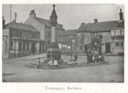
Although the symbol itself is a pre-christian one, to most of us it means that dreadfully boring religious crap we’ve had to contend with since childhood. But relics of old stone crosses, which scatter Britain in huge numbers, relate to periods in our history when the xtian ways were damning the ways of our indigenous ancestors – sometimes with frightening furore: burning, hanging and torturing British people for not accepting their screwy ways. The stone crosses which we find today as archaeological relics, tended to be positioned where earlier heathen sites were found – and as a result of this, I thought it important to include such sites on TNA. But these relics took various forms, each relating to the function of the site it meant to supplant or suppress: market crosses, boundary crosses, village crosses, wayside crosses, etc. You’ll find them all here!
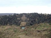
If you’re coming up to Oxenhope from Keighley, up the A6033 road, when you reach the school on the right-hand side of the road, a one-way street (Cross Lane) is where you need to walk down, for 200 yards, and keep your eyes peeled in the walling just before Cross Farm Court. Alternatively, via Haworth, go along Marsh Lane for a few hundred yards until your reach Moorhouse Lane on your left. Go down here for ⅓-mile (0.5km) and then go up Cross Lane on your right. About 120 yards up, in the walling just past the entrance into Cross Farm Court is where you’ll find it.
Archaeology & History
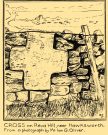
Very little seems to be known about the remains of this cross, embedded into the old walling. When it was described by Brigg & Villy (1914), they could find no information about it, and surmised that it marked the original track or road to Oxenhope from both Haworth and Halifax, “on the line of the old road by Withens.” Ostensibly it would seem to have been a wayside cross, marking old trackways (ley hunters take note!).
Visitors looking at it today can see that it’s barely noticeable. It looked no different even in Brigg & Villy’s days. It simply consists of only part of the original head of the cross, “the shaft having been broken off flush with the horizontal limb.” Some of the other stones that make up the bottom of this very poor-looking excuse of a cross were probably not part of the original, but were assembled into the wall to at least leave of memory of what it used to look like. It’s in a sorry state to be honest. A historic plaque should be placed here.
References:
Brigg, J.J. & Villy, F., “Three Ancient Crosses near Keighley,” in Bradford Antiquary, New Series 6, 1921.
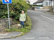
Easy to find: get into the middle of the village where the shops are in the main street and where another road veers off, the cross sits there in the middle in the traffic island. The photo here shows its location clearly.
Archaeology & History
Doune’s Mercat Cross
Found at the meeting of the roads in the centre of this old lovely village, the Mercat Cross in its present state was, according to Act of Parliament, erected a few years prior to 1696. Set on a square base of six steps in traditional pyramidal fashion, near the top of the 12-foot tall shaft are carvings on the sides of the stone. On the east-face was carved the Moray arms, and on the west face were carved sundials. John Small (1900) told how the top of the cross is crowned by the figure of a lion, “holding in its paws a circular shield or escutcheon, surrounded by a ribbon enclosing he Moray crest, and bearing the motto, ‘Salus per Christum.’
John Small’s 1900 sketch
It has been damaged a few times over the years. Sometime around 1800, Moray Mackay (1953) told that “the lion fell of and was damaged”, but was repaired shortly afterwards by a local man. He also told, with considerable indignation, how the local authorities were responsible for damaging what used to be “four short pillars which stood at the corners of the base,” when they were “smashed off and removed , impairing the balance of the whole (cross) for the sake of six inches more traffic room”! There are two such short pillars at the edges, but these aren’t the original stones. There used to be a water pump in front of the cross, but this was removed many years ago.
Cross (destroyed): OS Grid Reference – SE 2546 3537
Archaeology & History
Location of the old cross
In medieval times an old stone cross was erected at the edge of Bramley where two old tracks once met, and which today is the junction where Broad Lane meets with Outgang Lane. The cross is long gone – and even the stone cross base on which it stood no longer existed when the Ordnance Survey lads came here in the 1840s. All that remained when they came here were the place-names which have forever kept a memory of its former existence: Stump Cross Stile and Stump Cottage. It was mentioned, albeit briefly, in Wardell’s (1890) survey of Kirkstall Abbey where he told simply that a
“stone cross formerly stood some distance south of the Abbey by the side of the Old Road to Bradford, at the junction of the lane leading to Bramley, called the Outgang, but no remains of it are left; the site, however, is still known by the name of ‘Stump Cross Stile.’ Whether this cross marked the extent of some boundary, or was erected by the monks or others for the purposes of devotion for wayfarers, I am unable to ascertain.”
References:
Wardell, James, An Historical Account of Kirkstall Abbey, Yorkshire, Samuel Moxon: Leeds 1890.
Acknowledgements:Huge thanks for use of the Ordnance Survey map in this site profile, reproduced with the kind permission of the National Library of Scotland.
Cross (destroyed): OS Grid Reference – SE 3071 3463
Archaeology & History
In James Wardell’s (1890) work on Kirkstall Abbey he describes several of the long lost stone crosses that used to exist in the area. This one,
“formerly stood by the road side at the south end of Sheepscar Bridge, in Leeds.”
The cross had already been destroyed by the time the Ordnance Survey lads explored the area in the 1840s, as there’s no showing of it on any of their maps. Wardell further stated that it was,
“called Killingbeck Cross, from being erected by either the Abbot of Kirkstall or the Vicar of Leeds, of that name.”
References:
Wardell, James, An Historical Account of Kirkstall Abbey, Yorkshire, S. Moxon: Leeds 1890.
Pretty easy to find: from Whitby town centre, head uphill to the great ruins of Whitby Abbey. You go past Caedmon’s Cross and past the more recent church and graveyard to the car-park at the top, outside the abbey. At the edge of the car-park on the grass, you’ll see this tall hard upright, nice and erect!
Archaeology & History
Cross shown on 1894 map
Highlighted on the earliest OS-maps and not to be confused with the nearby and more modern Caedmon’s Cross, this tall large monolith stands upon a stepped plinth comprising of six steps (originally five), about 18 feet high. The top of the cross was knocked off a century or two ago, when it was reported to have been twenty feet! Initially it stood about fifty yards closer to the Abbey, but was removed to its present position following the Dissolution.
The brief history regarding its origin was described in George Young’s (1817) major work, in which he told that in 1474, on John Nightingale, rector of Sneaton parish, in his will “appointed his burial to be on the north side (of the Abbey), before the cross,” which was already standing at that time. Young wrote:
“By this it would appear that the ancient cross, now standing in the abbey plain was then within the cemetery of the abbey.”
Abbey Cross, c.1900Young’s 1817 sketch
This has subsequently been taken as the standard regarding its origin. Tradition also told that it was an old market cross, but this was treated with considerable scepticism by George Young, who believed that the monks here simply wouldn’t have allowed such a thing at the edge the abbey and burial ground. He found evidence to indicate that it “was at the port or harbour of Whitby that corn was bought or sold, that here were kept the standard bushels for measuring corn, and that here the market-clerk had his station.” In spite of this, T.H. Woodwark (1934) reported that fairs had been held at the cross early in the 20th century. In a thoroughly profane way, electrical wiring was wrapped around the bottom of the cross and led to a generator, along with washing-lines running from it to a caravan! Mr Young would have been apoplectic!
References:
Atkinson, J.C., Memorials of Old Whitby, MacMillan: London 1894.
Holt, Robert B., Whitby, Past and Present, Copas: London 1890.
Woodwark. T.H., The Crosses on the North York Moors, Whitby Literary & Philosophical Society 1934.
Young, George, A History of Whitby and Streonshalh Abbey (2 volumes), Clark & Medd: Whitby 1817.
Acknowledgements:Massive thanks to Lindsay (wherefore art thou…?) Mitchell for getting us up here… Huge thanks for use of the Ordnance Survey map in this site profile, reproduced with the kind permission of the National Library of Scotland.
Sitting quietly “on the village green, where the fair is still held,” wrote Wigram (1885), “stands the base of the old market-cross, reduced to a shapeless stump, but still bearing traces of leaden setting.” Thought to be mediaeval in age, it was described as a sundial on some of the early Ordnance Survey maps which, perhaps, it may have been used as for a short period (although records are silent on the matter). Standing just three-feet tall, this old stone pillar still lives on its ancient spot, as quiet as always, keeping itself to itself…
References:
Wigram, S.R., Chronicles of the Abbey of Elstow, Parker & Co.: Oxford 1885.
Nice ‘n easy: get into the village and walk through the church gates and there, on your left on the grass verge, a plinth and the cross-head sits before thee!
Archaeology & History
When the great Arthur Langdon (1896) wrote about Crowan’s cross-head, he was puzzled. At the time it was in the garden of a local surveyor in the nearby village of Praze-an-Beeble, but its origins seemed mysterious. The surveyor in question, a Mr William Carah, wrote to Langdon and said,
“It seems a mystery where the cross we have originally came from. A friend of mine, living abroad at present, saw it, I think, at a farm-place, being used as a bottom for a beehive. He asked the people for it, intending to fix it somewhere. At any rate, when he left England he had not done so, and at my request they gave the cross to me.”
The condition of the cross-head wasn’t too good and Langdon suggested it had “received some very rough treatment” – no doubt when it was hacked from its shaft. With his usual precision he gave the dimensions of the cross-head as follows:
“Height, 1 ft. 6 in.; width, 1 ft. 8 in.; thickness: at the bottom 6½ in., at the top 5½ in.
Front. — Part of a small conventional figure of Christ, extending to the knees, at which point the fracture occurred which separated the head from the shaft.
Back. — The remains of a mutilated Latin cross in relief.”
The stone shaft or menhir that once supported this carved head has, it would seem, long since been destroyed.
References:
Blight, J.T., Ancient Crosses and other Antiquities in the West of Cornwall, Simpkin Marshall: London 1858.
Courtney, R.A., The Evolution of the Wheel Cross, Beare & Sons: Penzance 1914.
Doble, Gilbert H., A History of the Parish of Crowan, King Stone Press: Shipston-on-Stour 1939.
Langdon, Andrew, Stone Crosses in West Cornwall, Federation of Old Cornwall Societies 1999.
Langdon, Arthur G., Old Cornish Crosses, Joseph Pollard: Truro 1896.
Two main routes to get here: i) from Dick Hudson’s public house, head left (east) along Otley Road (passing Weecher reservoir) for 1.9 miles (3.1km) until you reach Reva reservoir where a track leads you to the waters, and there’s a small parking spot on the left-side of the road. Stop here. (ii) coming from Hawkworth and Guiseley, head west along Hawksworth Lane which runs into Goose Lane and, at the T-junction at the end, turn right and nearly 500 yards along on the left-side of the road is the same small parking spot. From here, walk uphill for nearly 150 yards and then look at the walling to your left.
Archaeology & History
Reva Cross on 1851 map
This relic can be found on the far eastern edges of Hawksworth Moor, near Guiseley, and was said by the historian Eric Cowling to have originally stood upon a large rock nearby. It has an odd history. Initially, the cross was an ancient boundary or mark stone, referred to in a 15th Century document and outlined by William Preston in 1911, that marked the limit of the southern township of Burley township. Local historian C.J.F. Atkinson asserted that this cross in fact came from Otley, although his ideas were considered somewhat “fanciful” by archaeologists and other historians.
Its present position by the roadside is relatively new as it stood, not too long ago, a short distance away in the field to the rear, as highlighted on the early OS-map of this area. E.C. Waight of the archaeology division to Ordnance Survey wrote:
“Situated at SE 1530 4297 on the western side of the gate from the road into the field containing the remains of Reva Cross is a cross base (apparently in situ) serving as a bolster stone to the wall head at the gate opening.”
He described the dimensions of the base and the remainder of the cross, both of which “are contemporary with one and other,” he told. In the 1960s, the local council moved the cross to its present position.
Tradition told that despite its religious symbolism, it was also used as a market cross in bygone times. A certain Mrs Fletcher (1960), writing to the Cartwright Hall Archaeology Group, narrated that,
“Mrs Turner Greenwood….tells me that her mother, who, if living, would be in her nineties, lived at Gaping Goose Farm on the western side of Reva Hill… Mrs Greenwood’s father.. .remembered the cross erected on this hill, and related seeing the roads black with people climbing to it from Otley and Bingley, for the market held there.”
Despite this, Sidney Jackson was somewhat sceptical of it being the site of a market. Weather conditions and the bleakness of the spot would have made this site somewhat intolerable, he thought. However, people in previous centuries were much hardier than modern people and so it’s not as unlikely as you’d initially think.
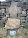
Close-up of cross
Sid Jackson’s sketch
A much more interesting tradition of the cross was its use in times gone by as a Plague Stone. However, this name only applied to the cross-base at the time as no cross was stood upon it; merely a natural rock laid upon the moorside with a basin cut into it. It gained this name around the time of the great plague of 1660. During the plague, food was left on this table-like rock and money in return was placed in a basin full of vinegar. This tradition may have originated at the large natural rock bowl on one of the earthfast stones near the very top of Reva Hill a short distance to the west (also a number of cup-marked stones are close by and folklore records show that some cup-marks had healing properties). One account tells that it was Sir Walter Hawksworth (of the legendary Grand Lodge of ALL England masonic lodge) who was responsible for the siting of the cross as a Plague Stone.
References:
Cowling, Eric T., Rombald’s Way, William Walker: Otley 1946.
Cowling, Eric T., ‘Letter,’ in Cartwright Hall Archaeology Group Bulletin, 5:5, May 1960.
Fletcher, Elsie, “Letter,” in Cartwright Hall Archaeology Group Bulletin, 5:5, May 1960.
Jackson, Sidney, “Ancient Crosses,” in Cartwright Hall Archaeology Group Bulletin, 1:12, 1955.
Jackson, Sidney, “Cross on Reva Hill,” in Cartwright Hall Archaeology Group Bulletin, 5:1, p.2, 1960.
Jackson, Sidney, “Reva Hill Cross Base Found,” in Cartwright Hall Archaeology Group Bulletin, 9:9, September 1964.
Jackson, Sidney, “Fresh Site for Reva Cross,” in Cartwright Hall Archaeology Group Bulletin, 11:7, July 1966.
Preston, William Easterbrook, “On an Ancient Stone Cross on Riva Hill,” in Bradford Antiquary, New Series 3, 1911.
Acknowledgements:Huge thanks for use of the Ordnance Survey map in this site profile, reproduced with the kind permission of the National Library of Scotland.
Nice ‘n easy: from Huddersfield central, take the A641 road north to Brighouse, but barely a half-mile out of town turn left up the Halifax Old Road. Go on here for nearly a mile, then keep your eyes peeled for the aptly-named South Cross Road on your right. Go up here all the way to the end where it meets with Cowcliffe Hill Road. Here, at the junction, right by the roadside at the edge of the wall, is the remains of the old cross-base, all but covered in vegetation. You’ll see it.
Archaeology & History
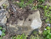
The little-known remains of a post-medieval cross base can still be seen, albeit very overgrown, right by the roadside. The upstanding stone cross that once stood upon it has long since gone (perhaps broken up and built into the wall). It may have been one of two such crosses relatively close to each other: as this one is found at South Cross Road, there may have been another one at the nearby North Cross Road, but history seems to be silent on the matter.
Top of the cross-base
The cross-base itself has several holes cut into it where the standing stone cross was fixed upright. Very little seems to be known about this monument. George Redmonds (2008) told simply that, “the base of a cross survives on Cowcliffe Hill Road, no doubt marking the ancient crossroads. It explains the names North and South Cross Roads.” He added that, “The base of the cross survives, partly hidden in the undergrowth, and it is the only visible evidence we have of several similar crosses in the township.”
References:
Redmonds, George, Place-Names of Huddersfield, GR Books: Huddersfield 2008.
Acknowledgements: Huge thanks to Liz Sykes for helping out big-time to uncover the base from beneath the mass of herbage.
Cross (destroyed): OS Grid Reference – SJ 2534 7208
Archaeology & History
Actual location of the cross
This long-gone site, described in the Domesday Record of 1086 as Atiscros Hund, (or “hundred”, which is the word given to an administrative division of land which, at that time, was on the western edge of Cheshire bordering Wales), gained its title from an old English personal name, Æti. The fact that it stood on an ancient boundary and was included in Domesday, means it would have been a stone cross. Its location was shown on the 1871 Ordnance Survey map (and several subsequent ones), based on traditional accounts about its position. The site is still preserved in local street-names.
Referring to the monument itself, Thomas Pennant (1796) said that it still existed in his day, telling that,
“A cross stood there, the pedestal of which I remember to have seen standing. There is a tradition that, in very old times, there stood a large town at this place; and, it is said, the foundations of buildings have been frequently turned up by the plough.”
References:
Dodgson, J.M., The Place-Names of Cheshire – volume 4, Cambridge University Press 1972.
Pennant, Thomas, The History of the Parishes of Whiteford and Holywell, B. & J. White: London 1796.
Taylor, Henry, Historic Notices, with Topographical and other Gleanings Descriptive of the Borough and County-Town of Flint, Elliot Stock: London 1883.