Cup-Marked Stone (removed): OS Grid Reference – SE 1579 3995
Archaeology & History
Jenny Lane carving
A small, seemingly broken cup-marked stone that may have once been part of a prehistoric tomb, found itself being included in an old wall at some time in the not-too-distant past: in the south-facing wall of the cricket ground at the top end of town. No one seemed to know it was there until it was noticed in the 1950s by a local man who brought it to the attention of Sidney Jackson (1958), editor of the local Bradford archaeology mag at the time. Jackson visited the site and thankfully did a sketch of what it looked like, before it was removed at a later date. He wrote:
“The small rectangular stone bearing four cup-shaped hollows…is another of Mr George Pritchard’s finds. It forms part of the high wall which bounds the Baildon Cricket Club’s ground in Jenny Lane… Its appearance suggests that it is part of a Bronze age cup-marked rock which was split to make building stones.”
Following its removal more than twenty years ago, it ended up in the hands of a dude from Cononley called Gerald Wright. I’m not sure whether it still lives over there or has subsequently found a new abode. Does anyone know what’s become of it…?
Folklore
Although there’s nothing specific to this carving, the place where it was found, on Jenny Lane, was where a phantom black dog used to be seen in bygone years. It was renowned as the harbinger od death.
References:
Jackson, Sidney, “Cup-Marked Stone in Jenny Lane, Baildon,” in Cartwright Hall Archaeology Group Bulletin, volume 3, part 10, 1958.
From Bainbridge, take the A684 road east to Aysgarth. Just out of the town, 200 yards over the bridge, take the right turn down Blean Lane. Nearly ½-mile along, take the minor road on your left and go along here for 1½ miles where, a few hundred yards before the solitary farm of Carpley Green (lucky buggers!), you can park up. (keep plenty of room for a tractor to get in the fields) Walk down the track past the farm and 250 yards along, where the first field ends, a gate leads you into the hills on your left. Go through here and then the next gate 120 yards on, then walk straight along th elong geological ridge ahead of you, veering to the top-side until it meets the walling. You’ll see the giant Stoney Raise cairn on the other side.
Archaeology & History
Stony Raise from above
The remains we find here are nigh-on immense! If giant cairns get you going (like the Great Skirtful of Stones or the denuded Devil’s Apronful near Pendle, etc), this one will blow you away! Along its widest axis, to this day it’s nearly 40 yards across and nearly 7 feet high! But in earlier times it was even bigger—much bigger! The first known description of the site was made by one Charles Fothergill, a Yorkshire-born politician and ornithologist, who wrote a diary of his walking excursions to various places in North Yorkshire at the beginning of the 19th century. (Romney 1984) His account of it was a good one for that period and thankfully he recorded information that would otherwise have been forgotten. After his visit here in September 1805, he told about this,
“wonderful tumulus called Stone raise which is a great curiosity: it is formed entirely of large stones piled up without earth or gravel, differing in that respect from any I have seen. Notwithstanding that upwards of a thousand, nay ’tis said several thousand, loads of stones have been led away from it to build walls with, it yet remains a stupendous monument of this species of antiquity: we measured the base of it as well as we could by our strides and made it 369 feet in circumference and of such an height as to be seen for a considerable distance. It has been most completely rifled…and it now presents a number of small craters formed by the investigations of the money searchers. It is situated upon a hill about half a mile south of Addlebrough. In addition to the particulars I formerly mentioned, I may say the men who first opened it about 50 years ago worked incessantly for 33 days. It stands on Thornton moor, and tho’ the Thornton men would not assist in the labour, they intended to share in the profit if there was any; but the adventurers who had all the work resolved they should not and they carried a large sword with them every day to defend the treasure in case they found any; the wise man who read ’till the stones shook and rattled was a schoolmaster at Bainbridge: the teeth they found were deposited in a hollow place in the bottom of the tumuli formed long and narrow like a coffin by a walling of stones. Tho’ the tumulus has apparantly been compleatly rifled, I do not believe the whole base has been sufficiently searched, but if it was to commemorate one great individual, which appears to have been the case, perhaps nothing more may be found.”
Fothergill’s description of “upwards of a thousand” cartloads of stone being removed from Stony Raise has been doubted by some archaeologists, but this claim should not be dismissed so lightly without evidence. There are immense tombs from northern Scotland to the unholy South that have remained untouched by the hand of industrialists that easily enter the category of such giants and this may have had equal stature.
A few years after Fothergill’s visit, Thomas Whitaker (1823) briefly described the site in his magnum opus, but added very little, simply telling that on the hills behind Addlebrough,
“there is still on that elevated spot a cairn, called Stone Raise, about 120 yards in circumference at the base, to which the usual tradition of its containing a treasure of gold having been attached, two persons were several years ago induced to make the experiment; but having penetrated to the centre, found, to their great disappointment, what an antiquary would have prepared them to expect, namely, a kist vaen of flag stones, with the remains of a human skeleton, the teeth of which were still pretty perfect.”
To this day the site remains unexcavated, so we don’t know too much about the place. It’s likely to have been constructed in neolithic times and its ancestral nature quite obviously venerated. It may have been re-used during the Bronze Age, but without excavations we may never know. A decent dig into this site is long overdue!
Folklore
This gigantic tomb is, not surprisingly, said to be haunted. Strange sounds and visions have been encountered here in bygone times. But the most well-known tale is that it was the site of a great treasure—perhaps hinted at by Fothergill. There are variations on the theme, but this is overall story:
Structured stonework
The tomb was said to be where a local giant had fallen and with him was buried a great chest of gold which he had dropped before he died. Some say that the ‘giant’ was a Brigantian chief – others a great warrior. The great treasure chest beneath the cairn is said to be looked over by a fairy who once lived by the giant’s tomb. It was this tale which gave the site its local name, the ‘Golden Chest on Greenber’. Several attempts have been made to find the treasure, but all have failed.
However, when the roving antiquarian Edmund Bogg came to write of the place in 1908, the giant had by all accounts been found within! He told us that,
The giant’s cist cover?
“this Kist-vaen was opened, many years back, and the skeleton of a chieftain of great stature was unearthed; the treasure chest of that or some other primal savage was not, and has not yet been discovered – for, take heed ye matter-of-fact money hunters, it is said the lucky one must first see the wraith of the ancient warrior to whom it belonged, who will then shew under which part of the immense Raise it is hidden! May this help any reader who is imaginative enough to find it – having seen the wraith he must keep silence – he has then but to stretch out his hand, and draw it forth.”
There are variations on this tale that have subsequently been penned by a number of Yorkshire folklorists, but this is the general lore. There was also a short rhyme told of Stoney Raise, that speaks of its apparent use through history by various races:
Druid, Roman, Scandinavia,
Stone Raise in Addlebro’.
References:
Bogg, Edmund, Wensleydale and the Lower Vale of the Yore, E. Bogg: Leeds 1906.
Bogg, Edmund, Richmondshire, James Miles: Leeds 1908.
Elgee, F. & H.W., The Archaeology of Yorkshire, Methuen: London 1933.
Gutch, Mrs E., Examples of Printed Folklore Concerning the North Riding of Yorkshire, David Nutt: London 1899.
Lofthouse, Jessica, Countrygoer in the Dales, Hale: London 1964.
Parkinson, Thomas, Yorkshire Legends and Traditions – volume 2, Elliot Stock: London 1889.
Pontefract, Ella, Wensleysdale, J.M. Dent: London 1936.
Romney, Paul (ed.), The Diary of Charles Fothergill, 1805, Yorkshire Archaeological Society: Leeds 1984.
Whitaker, Thomas Dunham, An History of Richmondshire – volume 1, Longman Hurst: London 1823.
White, Robert, A Landscape through Time, Great Northern: Ilkley 2002.
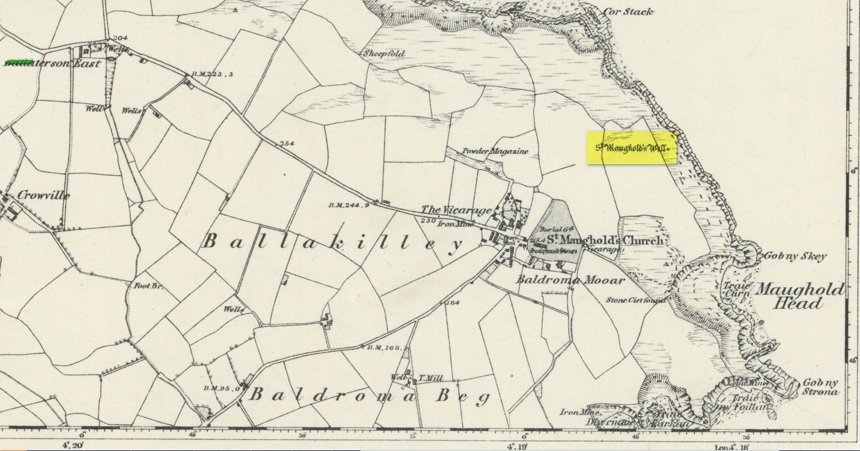
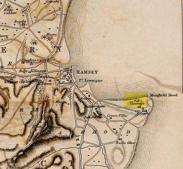
St. Maughold’s Well—also called Chibbyr Vaghal—is found on the northeast side of the headland on the cliff face about a hundred feet above the sea, a quarter mile from the St. Maughold’s church. It was a pilgrimage site which people visited on the dates of November 15 and July 31.
“…Beneath the head, under some moss clad rocks, is a deep spring, formerly much celebrated for its supposed medicinal virtues.” – George Jefferson, 1840
St Maughold’s on 1870 map‘Well’ on the 1836 map
Its medicinal properties are of great repute and was resorted to by many on account of its sanctity by crowds of pilgrims. The well was traditionally visited on the first Sunday in August, being the first Sunday after the Saint ‘s principal feast day, July 31 (significant in the Celtic calendar), but the devotions here have their origins in pre-christian times. The principal benefit at the well was a cure for sore eyes. After bathing the eyes or drinking the water it was/is customary to drop a coin, pin or button into it. Alternatively, a piece of cloth which had been used for bathing the eyes would be left by the well or on a nearby bush. As the cloth rotted, the ailment would be cured; while anyone who picked up the rags would himself receive the complaint associated with the offering; and to receive the full benefit of the well’s curative powers it should be visited on that first Sunday in August, and “while books were open in the church” — or in pre-reformation days, whilst Mass was being offered.
“…Where the spring gushes forth the rock has been hollowed into a small basin, and over it has been erected a simple shed of rough unhewn blocks of the rock immediately at hand. Hither the Saint is said to have resorted; nor is it altogether improbable that nearly fourteen hundred years ago at this very font he administered the baptismal rite. Certainly it was for many ages in great repute for its medicinal properties, and was resorted to on account of its sanctity by crowds of pilgrims from all parts. Nor is it yet forgotten.” – J.G. Cumming, 1848
“…A drink of its water, taken after resting in the saint’s chair close by, is supposed to be an unfailing cure for barrenness in women.” – A.W. Moore, 1890
Folklore
At Maughold churchyard above the well, ghostly whispers are said to be heard by the steps in the churchyard. This is interesting as when excavations were done here, the labourers found bones buried beneath the same steps. They were dug and exposed during the day and one worker who stayed in the church heard distant sounds, whispers and murmuring all around the church. When the bones were reinterred, the haunting stopped. (Bord & Bord 1985)
References:
Bord, Janet & Colin, Sacred Waters: Holy Wells and Water Lore in Britain and Ireland, Granada: London 1985.
Cumming, J.G., The Isle of Man: Its History, Physical and Ecclesiastical, J. van Voorst: London 1848.
Hall, John, “Earth Mysteries of the Isle of Man,” in Earth, no.17, 1990.
Moore, A.W., The Surnames and Place-Names of the Isle of Man, Elliot Stock: London 1890.
Jefferson, George, Jefferson’s Isle of Man, G. Jefferson: Douglas 1840.
Radcliffe, William & Constance, A History of Kirk Maughold, Manx Museum: Douglas 1979.
Acknowledgements:Huge thanks for use of the Ordnance Survey map in this site profile, reproduced with the kind permission of the National Library of Scotland.
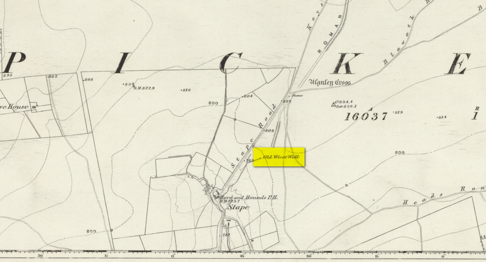
The history of the site is scanty to say the least. It first seems to have been recorded when the Ordnance Survey lads came here in the 1840s, although they left no record as to why the site was given such a dedication. It’s a decidedly pre-christian title as the name “old Wife” is usually indicative in northern counties as being related to the primal Earth deity of northern England and lowland Scotland (when we reach the Highlands and Ireland, She becomes known—amongst other names—as the cailleach). However, apart from its name we have no additional information. Neither the holy wells writer Edna Whelan (1989; 2001), nor hydrolatry researcher Graeme Chappell were been able to find anything about the place in their own researches. And so we must go on name alone…
The waters bubble up into a small stone-lined chamber with the words Nattie Fontein carved into the lintel. This is something of a mystery in itself, for, as Edna Whelan (1989) told,
“it would be most unusual for the word fonten to be used for a spring in North Yorkshire: ‘keld’ is the local word. The rather roughly inscribed word may be a corruption of Fons Natalis, the name of a Celtic water nymph.”
Graeme Chappell (2000) meanwhile, noticed in a visit to the site in June 1999,
“that the N and A in “NATTIE” are carved in such a way that the word could be read as “MATTIE FONTEIN” perhaps meaning “Mother Fountain”. This might then be another reference to the Old Wife?”
He then goes on to note how,
“the latin word ‘natalis‘ meaning ‘birth’ and its link with the roman Festival ‘Dies Natalis Sol Invictus‘ (day of the birth of the unconquered sun) which took place on the 25th December. Natalis also gave rise to the welsh word ‘Nadolig‘ – meaning Christmas.”
This Yuletide element has an intriguing relationship with the name of the well; for to the west of Yorkshire’s borders into Cumbria there was annual gathering known as Old Wives’ Saturday that took place on the first Saturday after Christmas, or first Saturday of the New Year in a person’s house or inn, where a feast was had to bring in the New Year; but there is no known written lore of such a tradition here.
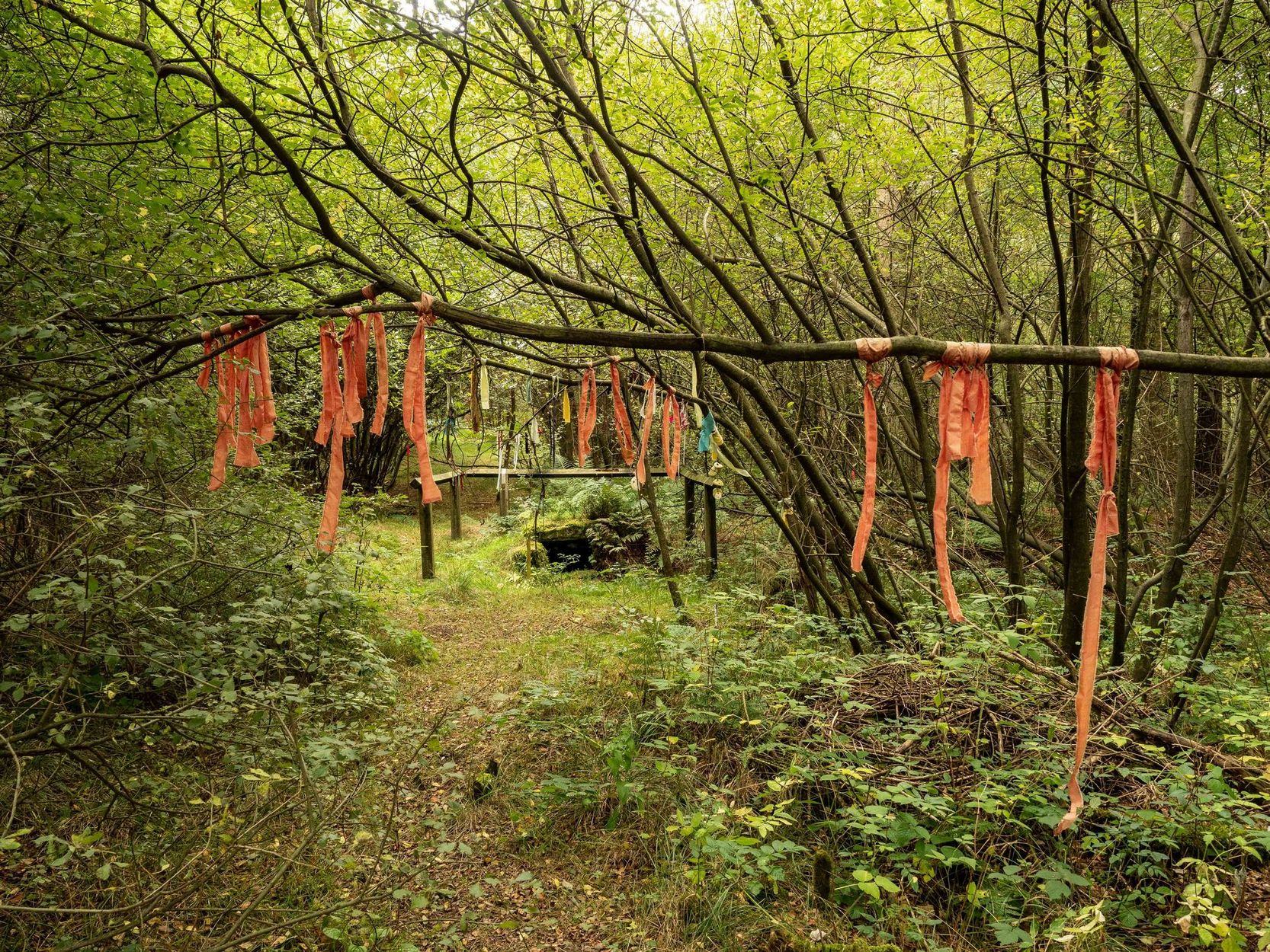
Nowadays the old tradition of hanging rags on the trees surrounding the well as offerings to the spirit of the place (known as memaws in parts of Yorkshire, and clooties in Scotland) has become a regular practice of those who hold such sites as sacred in their own way. Whelan mentioned seeing memaws here in the 1908s, but the Northern Antiquarian contributor Jon Barker told that, “The rags are a comparatively recent addition to the well, it is not a tradition there. When I used to go in the ’60s therewere no rags.”
On an even more curious note: very recently (from when this profile was written), the Northern Antiquarian contributor and photographer James Elkington visited Old Wives’ Well for the first time. It was a grey overcast day and when he arrived here, there was a woman ahead of him at the head of the well. I’ll let him tell the rest of it in his own words:
The Old Wives Well, Stape (James Elkington)Old Wives Well at Stape (James Elkington)
“In front of the well was a lady dressed in what looked like a white nighty, she had her back to me. There was a candle lit nearby, and her hands were in the water moving slowly about like she was washing something. She had long dark shoulder length hair. As I was about 25 feet away I was sure she wasn’t aware of me, and I thought it would make a good photograph. I quietly put my bag on the ground and got my camera out, and looked up and…she was gone! I couldn’t have taken my eye off her for more than 5 or 6 seconds. I looked all around and there was no sign of her. Even if she had legged it through the woods I would have seen her. I think it was then that I realized that I may have had ‘an encounter’. I quickly took three pics of the Well and got the hell out of there!”
He rang me once he had regained his senses in a somewhat emotional state and recounted over and over what had just happened. Whether this was a visual manifestation of the genius loci of the we can’t say. But such encounters are not unknown at numerous sacred water sites all over the world. We can only hazard a guess that this is what he was fortunate to encounter.
Just a few hundred yards north is the old Mauley or Malo Cross, which may or may not have had some mythic relationship with our Old Wives…
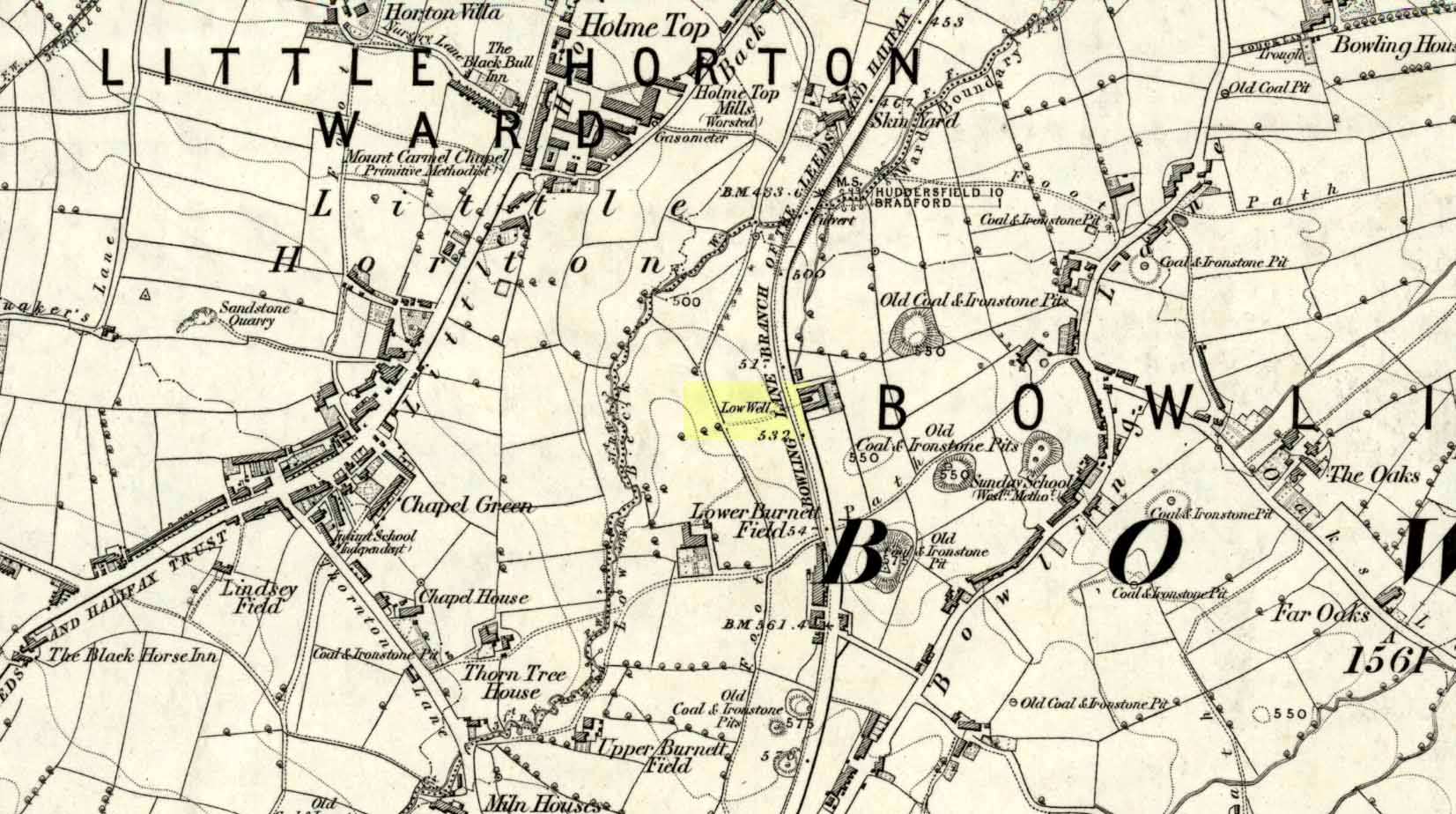
Sacred Well (destroyed): OS Grid Reference – SE 1589 3132
Archaeology & History
Low Well on 1852 map
Along the now-lost Low Well Road between Little Horton and West Bowling, could once be found this innocuous-sounding water source. Shown on the 1st OS-map of the area in 1852, the site was deemed to be little other than a ‘public well’. At the end of the 19th century, a small well-house was built over the waters; and the years following that saw its complete demise. Its name you would think relates to a position in the land, but the dialect word low, or lowe can mean “a flame, blaze, light, glow”, it can also refer to a prehistoric tomb. However in this case it most likely derives from “a pond or standing pool”.
…And if some of you wonder why I have given this so-called Public Well the provenance of being a “sacred well”, please keep reading…
Folklore
Although it was deemed a simple ‘public well’ by historians and the public water authority, local folk knew there was much more to it than that! In the Bradford area, this innocuously-named Well is the most promiscuously supernatural of all water sources, with a hidden history of magickians, ghosts and black dogs haunting its once ancient flow. It was a site remembered as having oracular powers, where local people used it in scrying the future. For such powers to work here, one had to gaze into the waters as they stilled at 6 o’ clock in the morning – a common time used by ritual magickians for the invocations of spirits.
The Bradford historian William Scrotum (1889) told us that in the 1860s, local people reported that the phantom black dog—or Bharguest as it was known—with its glowing red eyes, was seen coming out of the well after dark and scaring people half out of their wits. Very soon people would not even venture out after dark for fear of encountering this great harbinger of Death. Several years passed before local people called upon the abilities of a ritual magickian in the hope that he could lay the ghostly hound and bring peace and stability back to the hearts and minds of those living hereabouts. Eventually, after much work, the magickian exorcised the waters and cast the black dog back into the depths of the Earth from whence it had come and, to this day, sightings of the spectral hound have stopped.
Water sources that possess ingredients of hauntings, magic and oracular properties are universally ascribed as ‘sacred’ in one way or the other. In pre-industrial times I have little doubt that, amongst the animistic pantheon of local Bradfordians, this was no exception.
References:
Scruton, William, Pen and Pencil Pictures of Old Bradford, Thomas Brear: Bradford 1889.
Wright, Joseph, The English Dialect Dictionary – volume 3, Henry Frowde: London 1902.
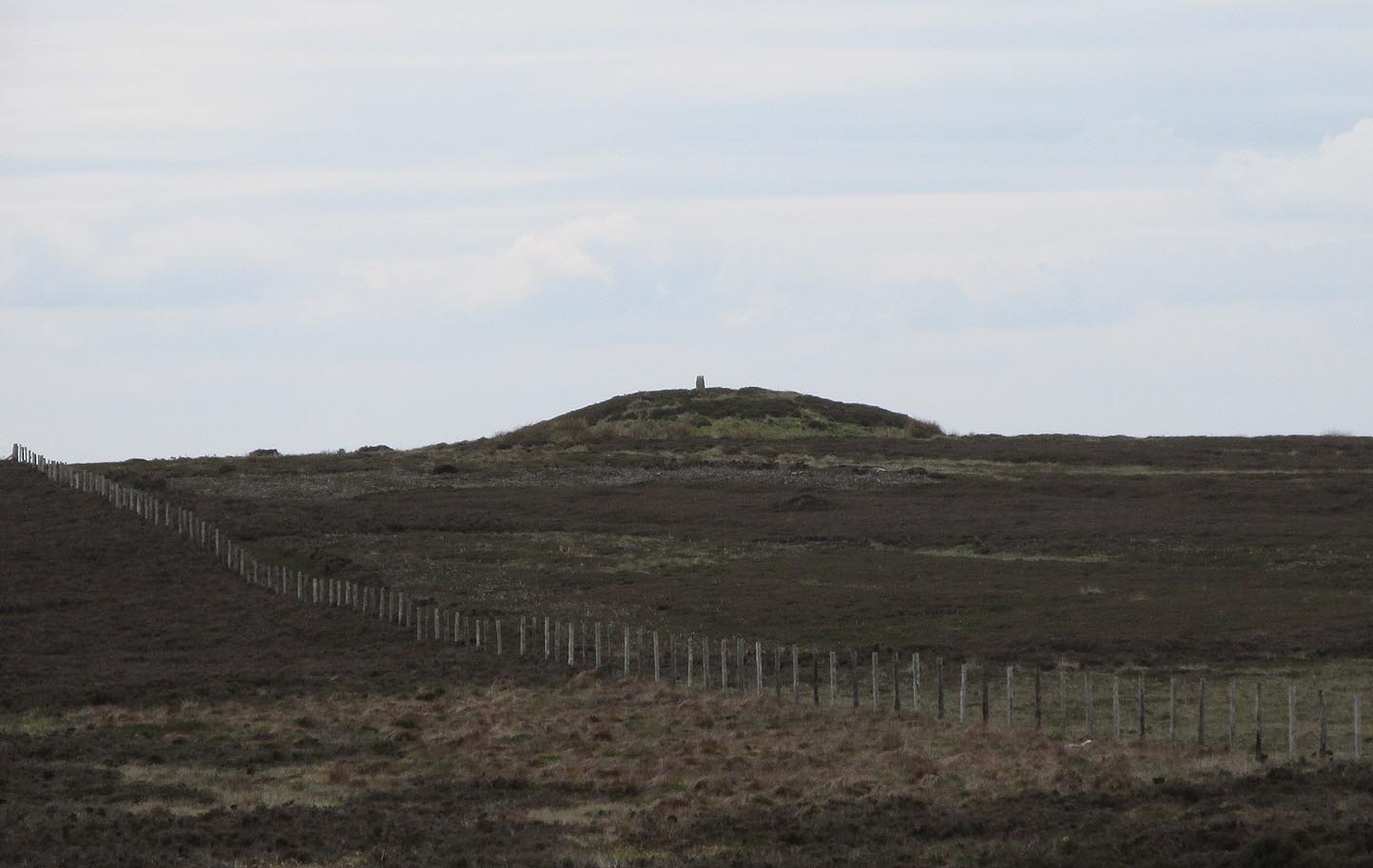
Along the A169 road between Sleights and Pickering, some two miles south of Sleights at the highest point on the moors just above the west side of the road, you’ll see a large mound with what looks like a standing stone on top of it. A minor road turns off the A169 at this point, heading southeast, and the large mound is 150 yards from the roadside. You can’t really miss it!
Archaeology & History
Shown on the first OS map of the area in 1853, this conspicuous prehistoric tomb surmounted by a relatively recent boundary stone, sits at the highest point on the moors in these parts. Despite this (as with others on these moors), very little has been written about the place and it has received only minimal attention in archaeology tomes. Even the renowned pen of Frank Elgee (1912; 1930) gave it only passing mention. Perhaps it aint a bad thing to be honest.
Breckon Howe, from the south
As well as being conspicuous, it’s large. Rising some six feet above the natural ground level, it measures 26 yards across its east-west axis, and 29 yards north-south, with a rough circumference of 88 yards. The boundary stone that surmounts its crown sits in a hollow that looks like it was opened up a century or two ago by antiquarians (much like ourselves). But its position of the tomb in the landscape that is most striking. The view from here is considerable, having a clear 360º view for many miles around. Other prehistoric tombs can be seen from here, but more importantly this tomb can be seen on the skyline from many others. This was probably a deliberate feature intended by its builders–and it’s not uncommon, as many of our upland regions are crowned with ancient tombs like Breckon Howe. In all likelihood this would have been the resting place of some important ancestral figure: a tribal elder or a shaman, whose spirit after death could view and travel across the landscape they inhabited in life.
Although the tomb presently sits amidst an endless sea of heather (Calluna vulgaris) typical of moorland across our northern lands, the name of the site ‘breckon’, according to George Young (1817) derives from the dialect word meaning ferns or bracken. This is echoed in Francis Kildale’s (1855) local dialect study and subsequently in Joseph Wright’s (1898) unequalled magnum opus.
Folklore
In the early 19th century, one George Calvert who lived in the area, collected as much folklore as he could, as it was dying off with the coming of the Church. One such piece told that there was once a hob who lived by this old tomb. A hob is generally known as a supernatural creature, but in this area it can also be a medicine man. Some hobs were good, others were malicious. We know not what type of hob lived lived here, but Calvert simply told us there used to be “T’ Hob of Brackken Howe”. Nowt more! It would be good to find the story behind this old character, if it hasn’t been lost entirely…
References:
Elgee, Frank, Early Man in Northeast Yorkshire, Frank Bellows: Gloucester 1930.
Elgee, Frank, The Moorlands of North-Eastern Yorkshire, A. Brown: London 1912.
Kildale, Francis, A Glossary of Yorkshire Words and Phrases Collected in Whitby and the Nieghbourhood, J.R. Smith: London 1855.
Home, Gordon, The Evolution of an English Town, J.M. Dent: London 1905.
Wright, Joseph, English Dialect Dictionary – volume 1, .Henry Frowde: London 1898.
Young, George, A History of Whitby and Streoneshalh Abbey – volume 2, Clarke & Medd: Whitby 1817.
Acknowledgements: A huge thanks to Lindsay Mitchell for getting us up to see this great tomb and its companion.
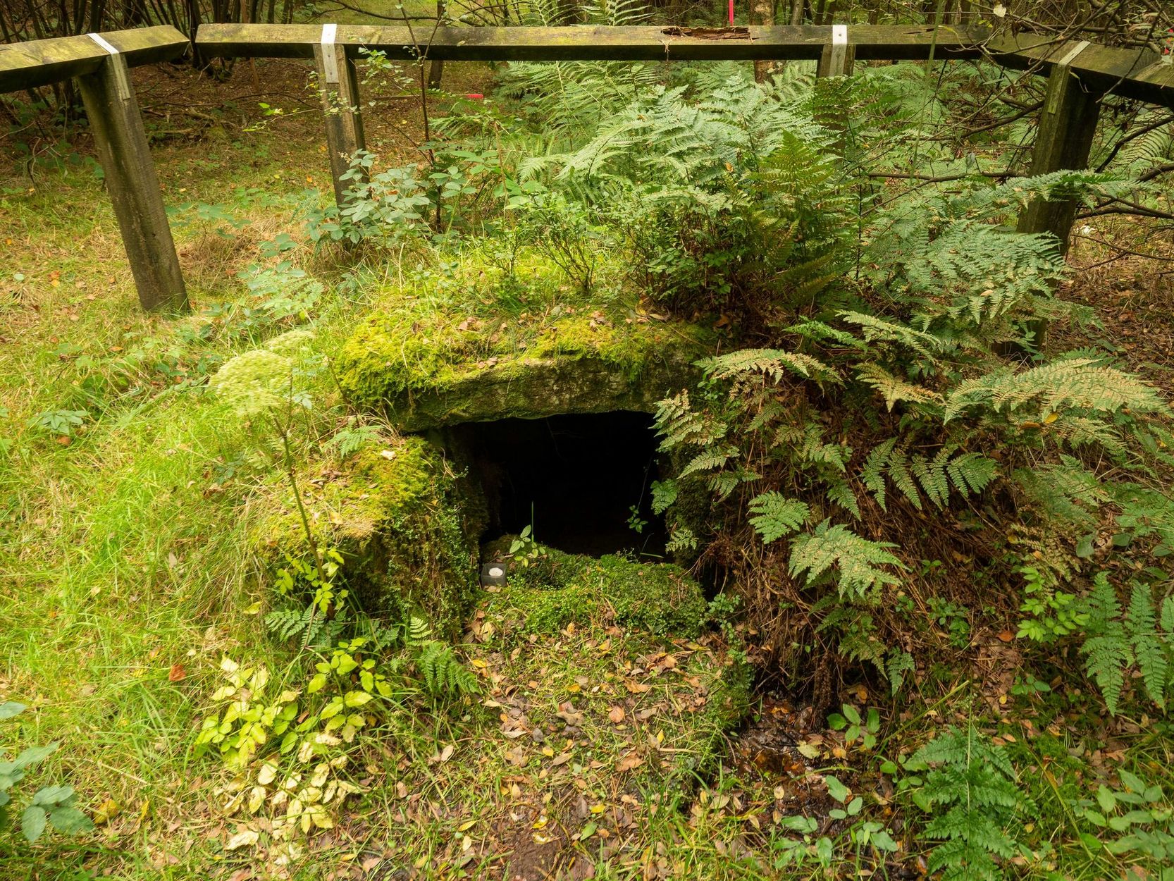
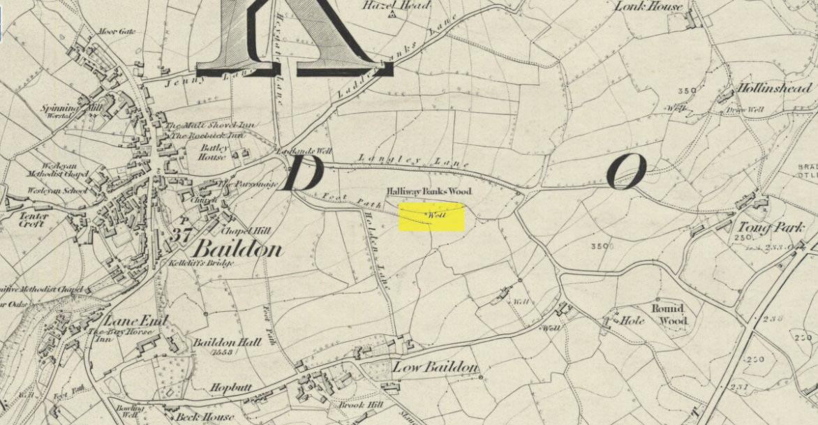
Holy Well (destroyed): OS Grid Reference – SE 1609 3961
Archaeology & History
This site is all but unknown to the great majority of folk in Baildon, and even some of the local historians have let it slip from their investigative tendrils. According to the primary Baildon historian, W.Paley Baildon, it was first known as the ‘Halliwell Holy Well’. In his magnum opus (1913-26) of the township he relates that,
“The 1852 Ordnance map marks Halliway Banks Wood to the south of Langley Lane, with a well just below it, and a footpath from Holden Lane to the well. Halliway, I think, is a corruption of Halliwell, the ‘holy well,’ with the special footpath leading to it and nowhere else. Haliwell Bank occurs in (the Baildon Court Rolls of) 1490, when it formed part of the property held by William Tong of Nicolas Fitz William.”
This etymology is echoed by the great place-name authority A.H. Smith (1954). It also caught the attention of archaeologist Andrea Smith (1982), in her investigation of twenty-five holy wells in the West Yorkshire region.
“Many wells,” she wrote, “are recorded simply as ‘Holy Well,’ or the various forms ‘Halliwell,’ ‘Helliwell’ and ‘Hollowell.’ It is possible that in these instances the identity of the patron saint or guardian of the well has been forgotten, which may be the case with the site at Collingham, now known as Hollowell.”
Site of the Holy Well in 1852
The well itself can no longer be seen. When I looked for the site in 1982, I found that to the right of where the 1852 map showed it, was a waterworks lid covering the old holy waters, just in the trees atop of the field beneath a great sycamore with a number of small stones roughly encircling the site: perhaps the only possible relics of the century before when the waters would have been used. A stone trough was situated at the bottom of Holden Lane, fed by the waters from the Halliwell and from here the course of the stream meandered down the side of Slaughter Lane, now known as Kirklands Road. The land around Halliwell became known as Kirkfield, or field of worship.
A local resident told how during autumn and winter, the left side of the field gets extremely boggy – the region were the old stream ran from the old well, along which dowsers have found aquastats abound. Now however, houses have been built where the waterworks-lid used to be and is likely to be in someone’s backyard, all but forgotten.
Folklore
According to local lore, the site of this most ancient of holy wells was found in the warmest place in the Baildon district. Whilst its geographical position doesn’t necessarily suggest this (although it did face south, into the sun), this lore may reflect some healing aspect of the well that has long since been forgotten.
Perhaps relevant to Andrea Smith’s comment about there being ‘guardians’ at holy wells is found in folklore relating to nearby Holden Lane: locals in the last century also referred to it as Boggart Lane, so called after the Boggart which was seen there in the form of a spectral hound that was said to possess large glowing red eyes and was a sign of ill omen. Modern sightings of the spectral hound, which appeared along the road which led to the old well, are unknown.
References:
Baildon, W. Paley, Baildon and the Baildons (parts 1-15), St. Catherines: Adelphi 1913-26.
Smith, A.H., English Place-Name Elements – volume 1, Cambridge University Press 1954.
Smith, Andrea, ‘Holy Wells Around Leeds, Bradford & Pontefract,’ in Wakefield Historical Journal 9, 1982.
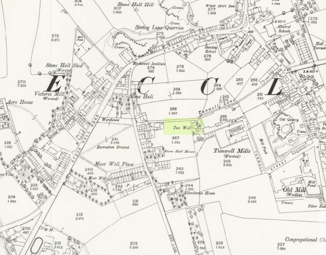
First mentioned in local history accounts from 1618—as the Tunwells—it was highlighted on the first OS-map of Eccleshill in 1851. Located on the aptly-named Tunwell Lane, it was a deep well covered by a large flat slab of stone, at the back-end the old Victorian mill. The stone was put there to prevent children falling into it. Some old locals thought the name of the place derived from a ‘tun’, or hundred, meaning it to be a hundred feet deep; although as A.H. Smith (1961) tells, tun could equally relate it to be one of Eccleshill’s town wells, of which there were several. It used to be one of the principal drinking supplies for the village and was said to rarely run dry. In William Ranger’s (1854) survey, he told this to be one of the sites to which local people relied in times of drought, where the land-owner allowed local folk to collect their supplies.
Folklore
The old cobbled Tunwell Lane was long ago supposed to be the haunt of a phantom black dog: a visionary precursor of death and Underworld guardian. Its spirit came and went into the deep well. I remember hearing tales of this when I was a young lad, as the old women who worked in the adjacent mills spoke of it. The ghost of a so-called ‘white lady’ was also said to walk along Tunwell Lane.
In more recent times, Val Shepherd (2002) included this in her short survey of wells in the area as being on “an alignment” with Eccleshill’s Moor Well and Holy Well. She thought “it may be part of a ley line”, but her alignment is inaccurate and doesn’t hit the spots.
References:
Crapp, H.C. & Whitehead, Thomas, History of the Congregational Church at Eccleshill, Watmoughs: Idle 1938.
Ranger, William, Report to the General Board of Health on a Preliminary Inquiry into the Sewerage, Drainage, and Supply of Water, and the Sanitary Condition of the Inhabitants of the Township of Eccleshill, George Eyre: London 1854.
Shepherd, Val, Holy Wells of West Yorkshire and the Dales, Lepus: Bradford 2002.
Smith, A.H., The Place-Names of the West Riding of Yorkshire – volume 3, Cambridge University Press 1961.
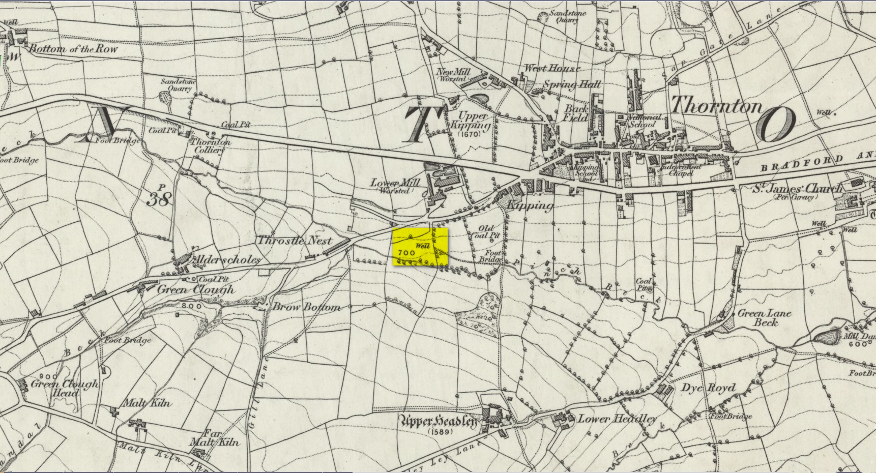
Another well with considerable supernatural renown was this little-known site near the old village of Thornton, on the western outskirts of Bradford. We’re not 100% sure about its exact location, but the grid-reference cited here is of an old ‘Well’ that was highlighted on the first Ordnance Survey map of the region, at the end of solitary path which led to it and nowhere else. Our only documentary information comes from Elizabeth’s Southwart’s (1932) fine old book on the folk life of the old village, as it once was. At a place once known as Bent Ing Bottom, just south of the old village, is where it used to be known. The name of this Well is also curious, as no historian has yet worked out who the ‘Jim Craven’ was, nor what his relationship to the site might have been. It’s the folklore of it, however, which brings it the attention it deserves.
Folklore
In Elizabeth Southwart’s (1923) work, she told us that the place once known as “Bent Ing Bottoms have lost their romance.” She continued:
“Whether the golfers have driven it away—for the fields now form part of the Thornton Golf Links—or whether the advance of modernity in other forms is to blame, it is difficult to say. Once they were the haunts of “Peggy-Wi-T’-Lantern” and the Bloody-tongue. Peggy, a dame in a white mob cap, kilted skirt and white stockings, walked about with a lantern, enticing the unwary traveller to his doom. She was given to wandering, for, they say, Jim Craven Well, half a mile away, was a place to be avoided after nightfall.
“The Bloody-tongue was a great dog, with staring red eyes, a tail as big as the branch of a tree, and a lolling tongue that dripped blood. When he drank from the beck (known as the Pinch Beck, PB) the water ran red right past the bridge, and away down—down—nearly to Bradford town. As soon as it was quite dark he would lope up the narrow flagged causeway to the cottage at the top of Bent Ing on the north side, give one deep bark, then the woman who lived there would come out and feed him. What he ate we never knew, but I can bear testimony to the delicious taste of the toffee she made.
“When the dark was coming we used to sit on the filled-in pit, which makes a hump in the middle of the field, and wait for him. The sun would sink redly, through the arches of the viaduct, the trees that lined the beck would grow an ever darker green until they became black, the beck would begin to gurgle and gulp in a queer way; and down in the hollow we would hear a whimper, a whine, a moan, a snarl. Then, with scalps and spines playing queer tricks, we would wait and wait. But none of our little band ever saw him, except one girl, and she saw him every time.
“One Saturday a girl who lived at Headley came to a birthday party in the village, and was persuaded to stay to the end by her friends, who promised to see her ‘a-gaiterds’ if she would. As soon as the party was over the brave little group started out. But when they reached the end of the passage which leads to the fields, and gazed into the black well, at the bottom of which lurked the Bloody-tongue, one of them suggested that Mary should go alone, and they would wait there to see if anything happened to her.
“Mary was reluctant, but had no choice in the matter, for go home she must. They waited, according to promise, listening to her footsteps on the path, and occasionally shouting into the darkness:
““Are you all right, Mary?”
““Ay!” would come the response.
“And well was it for Mary that the Gytrash had business elsewhere that night, for her friends confess now that at the first sound of a scream they would have fled back to lights and home.
“We wonder sometimes if the Booody-tongue were not better than his reputation, for he lived there many years and there was never a single case known of man, woman or child who got a bite from his teeth, or a scratch from his claws. Now he is gone, nobody knows whither, though there have been rumours that he has been seen wandering disconsolately along Egypt Road, whimpering quietly to himself, creeping into the shadows when a human being approached, and, when a lantern was flashed on him, giving one sad, reproachful glance from his red eyes before he vanished from sight.”
Southwart later tells us that the ghostly dog travelled into the north and vanished. From the description she gives of the children walking their friend to “the end of the passage which leads to the fields, and gazed into the black well, at the bottom of which lurked the Bloody-tongue,” I can only surmise that the solitary well shown on the very first OS-map of Thornton at the coordinate given above is the place in question.
The ‘Bloody Tongue’ is first mentioned in Yorkshire folklore, I think, by Roger Storrs, in his article on holy wells in 1888, where he tells it to be one of the mysterious beings that live, usually at the bottom of the waters and almost universally used “to deter children from playing in dangerous proximity to a well.”
From the description of the waters turning red when the ghostly dog drank from it, we have a mythic account of when the waters occasionally turned red from the iron-bearing waters (chalybeate) which, obviously, wasn’t like this at all times. Whether this was a sporadic, unpredictable flow of iron in the waters, or a cyclical pattern of the water-flows, we are not told (which would imply, moreso, that it was sporadic). The folklore about this ghost and its appearance with another elemental creature along an old straight track running north from Upper Headley Hall to Thornton is intriguing—as in many old pre-christian traditions, North is the airt, or direction, representing Death; and black dogs are traditionally guardians of underworld treasures in the land of the Dead. With the plethora of other animistic folktales once known in this district (boggarts or goblins were known in nearby woods, wells and farms) it is likely that the origin of such folklore dates way back into antiquity.
References:
Bennett, Paul, Ancient and Holy Wells of West Yorkshire, forthcoming
Southwart, Elizabeth, Bronte Moors and Villages: From Thornton to Haworth, John Lane Bodley Head: London 1923.
Storrs, Roger, ‘Legends and Traditions of Wells,’ in Yorkshire Folk-lore Journal – volume 1 (ed. J. Horsfall Turner) 1888.
West of Dunipace and the M9, go along the B818 for 3-4 miles until you hit the pub at the tiny crossroads of Carron Bridge. Take the lonely road up to your right and after several miles, just where the forest on your left finishes, a bend in the road takes you over a small river. Stop here and walk up the track left, to Craigengelt. Before you reach the farmhouse at the end, note a small clump of trees ahead of you. Just before this, a seemingly natural rounded hillock in the field, just off the trackside, is where the monument used to be.
Archaeology & History
No trace remains of this once-important and seemingly impressive prehistoric ‘tomb’ or ritual death chamber, just off the trackside before old Craigengelt farmhouse. The standard history of the site, repeated variously by Royal Commission (1963) and elsewhere, was first sourced in the New Statistical Account of the region in 1845:
“About two years ago the tenant was engaged in levelling and improving a field on the eastern extremity of Craigengelt in which there was a large cairn or mound, known in the country by the name of the “Ghost’s Knowe.” It was quite circular, exactly 300 feet in circumference at the base, and which was flanked around by twelve very large stones, placed at equal distances, and it was 12 feet high, with a slight inclination to one side, and fiat on top. On removing the turf and soil, it was found that the interior consisted of large and small stories built together with great care, which led the proprietor to think that it must have been a place of Druidical sepulture.
“About 6 feet from the centre, there stood four upright stones, each about 3 feet in height, describing an oblong figure like a bed. Within this a coffin was found, the length of which was about 7 feet, at broad, and at deep. The under part or bottom of the coffin was whin-flag, as was also the upper part or lid. Within this were found the remains of a human body of the ordinary size. The hones, except a very small part of the skull, were of the consistence of soft chalk, the body had been enveloped in something like a mixture of decayed vegetable matter and tar, which, when exposed to the atmosphere, emitted a strong odour.
“Strict orders were given to the labourers that if anything like a coffin should be found, they were not to open it until either the proprietor or tenant were present. But one of them, an old schoolmaster, who knew something of antiquities, went during the night, and carried off a variety of articles, the nature and number of which are not now likely ever to be ascertained. With reluctance, he gave up a stone axe of beautiful workmanship and a gold ring. The ring had had a jewel in it; but the jewel was out, and it was what is called “chased,” and must have been worn on a very small finger. A labourer in the neighbourhood sold a variety of things of a rare description to a gentleman in whose possession, it is believed, they still are. The axe and the ring were the only things obtained by the proprietor, J. Dick, Esq. of Craigengelt, and they are still in his possession.”
When Daniel Wilson (1851) visited the site a few years later, he discovered a little more about the valuable items discovered in the tomb:
“among which was a golden horn or cup, weighing fourteen ounces, and ornamented with chased or embossed figures. This interesting relic was purchased from one of the labourers by a gentleman in Stirling, and is believed to be still in existence, though I have failed, after repeated applications, in obtaining access to it. The exact nature or value of the whole contents of this cairn is not likely ever to be ascertained. The only articles secured by the proprietor, and now in his possession, are a highly polished stone axe or hammer, eight inches long, rounded at one end and tapering at the other; a knife or dagger of the same material, eighteen inches long, which was broken by one of the stones falling on it when opening the cist; and a small gold finger-ring, chased and apparently originally jewelled, though the settings have fallen out.”
The structure of the Ghost’s Knowe is similar in size and stature to another, large unrecorded round cairn or tumulus, 2.25 miles (3.62km) NNW of here, that still requires our full attention.
Folklore
Despite the name and the tale said by local people that “the place was haunted”, I can find no details that tell the story of the hauntings here. Does anyone know?
References:
Royal Commission on the Ancient & Historical Monuments Scotland, Stirling – volume 1, HMSO: Edinburgh 1963.
Royal Commission on the Ancient & Historical Monuments of Scotland, Archaeological Sites and Monuments of Stirling District, Central Region, Society of Antiquaries of Scotland 1979.