Holy Well (destroyed): OS Grid Reference – NN 9677 5199
Also Known as:
Fuaran Chad
St. Cedd’s Well
Archaeology & History
All trace of this once renowned holy well seems to have gone. It was located, according to the local historian James Kennedy (1927) “on the terrace behind the Church”; although Charles Stewart (1880) earlier told that it was found on the hillside above the church. On our recent visit here, the level piece of land just above the River Tay, “on the terrace behind the Church” as Kennedy told, had no notable spring of water upon it—but we didn’t check the slope above the road to see if there was anything there. By all accounts it’s long since gone.
There’s also slight confusion regarding the dedication of this well. Kennedy, once more, ascribed it to have been St Cedd’s Well, the brother of St Chad, and not Chad himself who was venerated here. But this wasn’t the view of MacKinlay (1893) or Knight (1933) in their major studies. But let’s leave that element to the hagiologists for the time being!
Tradition told that the spirit of the waters was deeply offended when the annual market in Logierait—dedicated to St Chad/Ched on his saint’s day of August 22—was stopped. As a result the waters removed themselves and fell back to Earth. This curious motif is found at a number of wells in other parts of the country.
References:
Kennedy, James, Folklore and Reminiscences of Strathtay and Grandtully, Munro Press: Perth 1927.
Knight, G.A.F., Archaeological Light on the Early Christianizing of Scotland – volume 2, James Clarke: London 1933.
MacKinlay, James M., Folklore of Scottish Lochs and Springs, William Hodge: Glasgow 1893.
MacKinlay, James M., Influence of the Pre-Reformation Church on Scottish Place-Names, William Blackwood: Edinburgh 1904.
Mitchell, Hugh, Pitlochry District: Its Topography, Archaeology and History, L. Mackay: Pitlochry 1923.
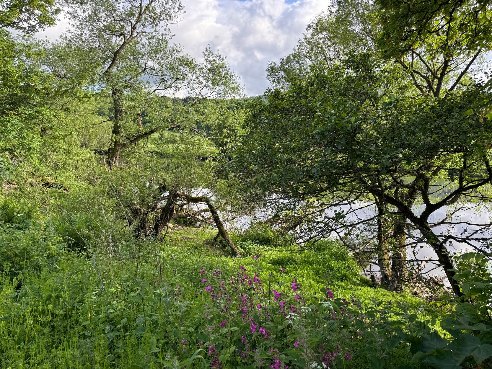
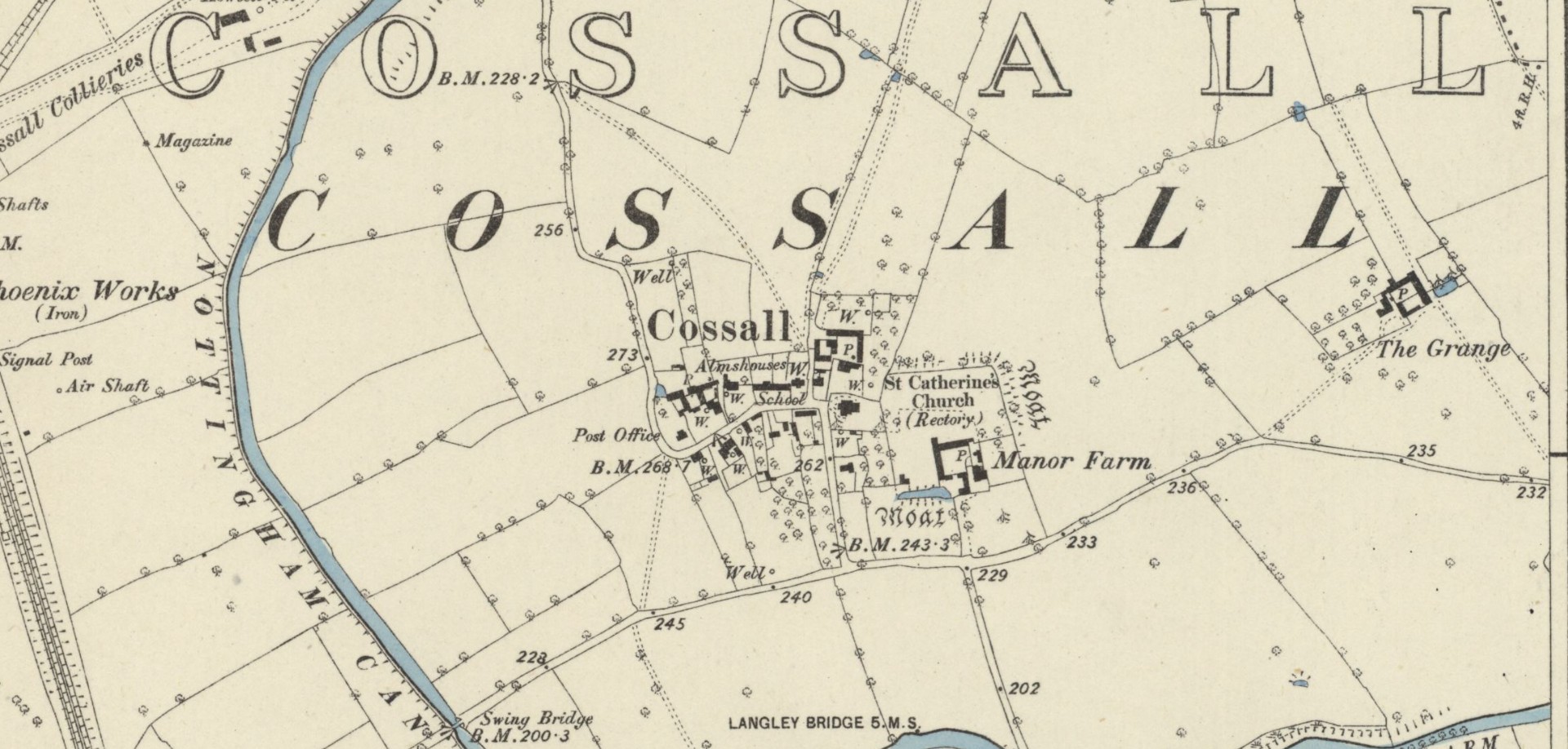
Hiding away in the Title Deeds of the Willoughby Family of Wollaton, written around 1280 CE, a somewhat lengthy entry on land ownership around the parish of Cossal, showed there once existed a little-known St. Helen’s Well: long since lost it would seem. The account, known as the “Quitclaim (of) William son of Adam le Gaoler,” cited the following information:
“Release by William, son of Adam le Gaoler of Nottingham, and Beatrice (his wife) and Agnes (heirs once of Adam de Cossale in Nottingham) to William de Barre and his wife Dionise [Denyse] of all claims to toft and croft with all its appurtenances, with 10 seliones of arable land with appurtenances in various parcels and sites in town and territory of Cossall; the toft and croft lie between land of Dionise on each side; 3 seliones lie together on Brochisale, 2 lie on Elrinstubbe between land of Robert de Marisco and William Baret, 2 lie on Smalethornchis between land of Henry and Robert son of Adam, 2 lie a square furlong ‘quarentelam’of the spring of St. Elena between land of Stacy le Greyne and Nicholas de Marisco and 1 selione lies on le Westfeld between 2 boundaries.”
A few years later in an early 14th Century Feet of Fines there is another mention of the well, which gave a slightly better description of its whereabouts. It mentions items known as ‘sellions’, which are strips of arable land. The account told of,
“two selions lying together at St Helen’s Well between the land of the church of St Katherine of Cossale on one side, and the land of the said Eustace on the other side, abutting at one end on the croft that Walter Talpe holds, and at the other end upon the north conduit…”
This indicates that the well was close to the village—perhaps even within the village itself. On the early Ordnance Survey maps of Cossall, several wells are shown, and any one of them could be the St. Helen’s Well in question. Does anyone know which one is the forgotten holy well of the village…?
Folklore
St Helen’s feast day is August 18.
References:
Gover, J.E.B., Mawer, Allen & Stenton, F.M., The Place-Names of Nottinghamshire, Cambridge University Press 1940.
Morrell, Robert, Nottinghamshire Holy Wells and Springs, Nottingham 1988.
Acknowledgements:Huge thanks for use of the Ordnance Survey map in this site profile, reproduced with the kind permission of the National Library of Scotland.
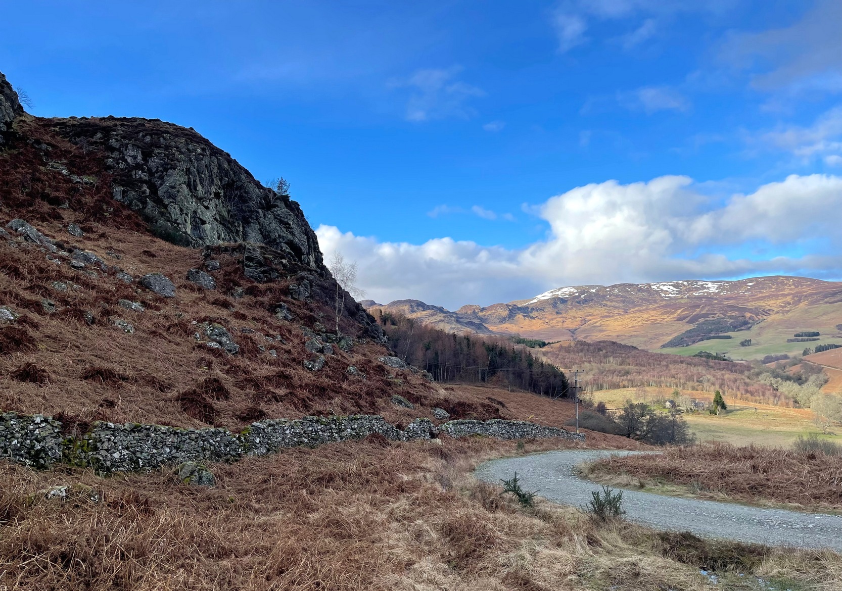
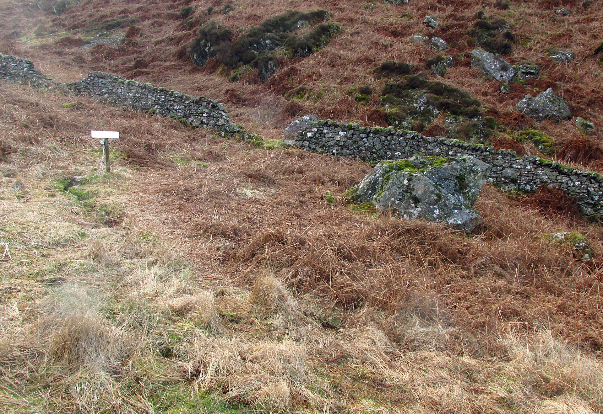
From Comrie village, take the long winding steep road up past the Devil’s Cauldron towards Glen Lednock. After 1½ miles the road begins to level-out and you come out from the trees and about 400 yards along there’s a dirt-track on your left. Park here! OK, now walk further along the road (not the dirt-track) for less than 100 yards and take the footpath up the slope (if this is blocked—it shouldn’t be!—you can walk further along until your reach the next track on your left). Go up this footpath for 200 yards till you reach the track by the large bend; and then walk up it for another 200 yards where there’s another large bend. On your right, past the solitary big rock, you’ll see the sign…
Archaeology & History
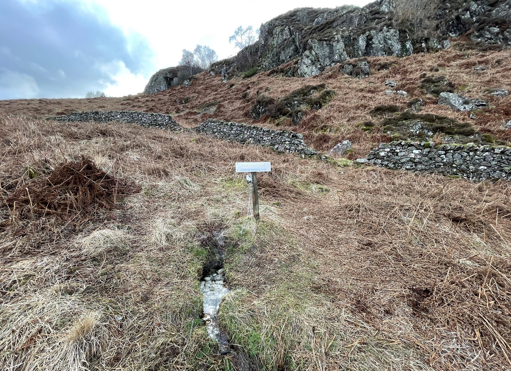
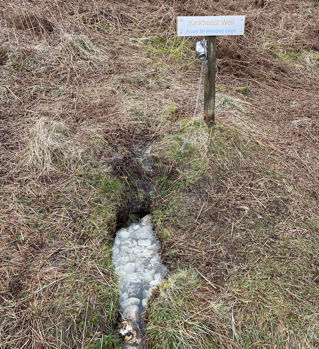
Sign of the Kinkhoast Well
A little-known healing well that all but fell out of existence until, thankfully, some local folks recently decided to revive it. A sign stands above the back of this spring of water as it emerges from the Earth telling you that it’s the Kinkhoast Well. Its clear waters form into a very small pool, wherein are dozen of small white pebbles and and quartz pieces, very smooth and obviously worn by decades, if not centuries, of local folk giving the spirit of these waters—the genius loci—and offering in exchange for its healing virtues in the hope that it cures them of the whooping cough, of which this well is renowned.
It’s one of many whooping cough wells that are found in the Perthshire hills—and most are actually large boulders with hollows into which the rainwater collects and it is this that is used medicinally and not necessarily the spring water. A curious thing indeed…. and I’ve come across Highland folk who were taken to them when they were young children who’ve told me that their whooping cough was subsequently cured! Intriguingly, there is a large boulder just below this well, upon whose top is a natural bowl in which rainwater collects—and although I can find nothing specific telling of such a tradition here, above Comrie, it’s possible that the relationship between stones and wells, found at other places in the Highlands, also existed here.
Small pool full of white offering stonesWell & stone in close attendance
The name Kinkhoast itself (and variables thereof) is a Scottish dialect word, found from Galloway and into the Highlands. Jamieson (1880) describes it as literally “hooping cough”, with a brief note on the disease being cured by water drank from a shell. Meanwhile, in Grant & Morison’s (1960) massive work, they give numerous examples of the term, most of which relate to the same “whooping cough”, with some examples of folk remedies to abate the disease, including one of parents sending their children to take a drink from the “Kinker Steen Wall”—in that case from the parish of Logie. Examples of the very same tradition are known at other kinkhost sites. Check the place out when you’re in the area—and rest for a while to drink in the beautiful views…
References:
Anonymous, “Comrie Folklore – Kingcough Well,” in Crieff & District Post, no.31, August 2012.
Grant, William & Morison, David D. (eds), The Scottish National Dictionary – volume 5, SNDA: Edinburgh 1960.
Holy Well (destroyed): OS Grid Reference – SW 7202 5073
Archaeology & History
Not to be confused with another St. Agnes’ Well near the coast just 1½ miles southwest of here, this ‘holy well’ was found in the middle of the town itself. It was first described sometime between 1710 and 1720 by a certain Thomas Tonkin who penned lengthy notes about the history of the parish of St Agnes and, therein, mentioned this Well which was, he said, located “by the Cross before the Church.” But it had already been drained and “cut off”, as he put it, some years prior to him writing his notes.
More than two hundred years later, on 3 December 1931, the West Briton & Cornwall Advertiser reported on an excavation that took place of the nave of St Agnes church. The vicar, a Rev W.H. Browne, said that,
“On the west side there was evidence of water, which might have been a spring and possibly the holy well. We shall have to preserve it if it turns out to be what we anticipate it is. How this is to be done, I do not know, but we cannot allow it to be covered in again without doing something. It is creating tremendous interest, and will cause a great fight among the experts.”
Several years later, the great Cornish hagiographer Gilbert Dobie (1940) also mentioned the excavation, noting the wet area which they believed was the location of the well, also noting, “at the same time…the finding of remains of an earlier chapel.”
References:
Doble, Gilbert H., History of St Piran, 1940.
Tonkin, Thomas, “The Parish of St Agnes,” in Journal royal Institute Cornwall (eds. P.A.S. Pool & H.S Douch), volume 7 (2nd series), 1975.
From the Port Appin ferry onto the northern tip of the island, go along the B8045 road for literally 3.5km (2.17 miles) and, shortly after passing Achuaran, a single small white house is on your right. Just yards before here is a small raised rocky knoll. …Or from the Achnacroish ferry, up the road for nearly a mile, then turn right along the B8045 road to Clachan. A half-mile past the hamlet, go past the old School House, then past Mountain View cottage, and the next small white house on the left has a rocky knoll just past it. Just over the wall from the road, a sign points out the legendary Chair that you’re seeking!
Archaeology & History
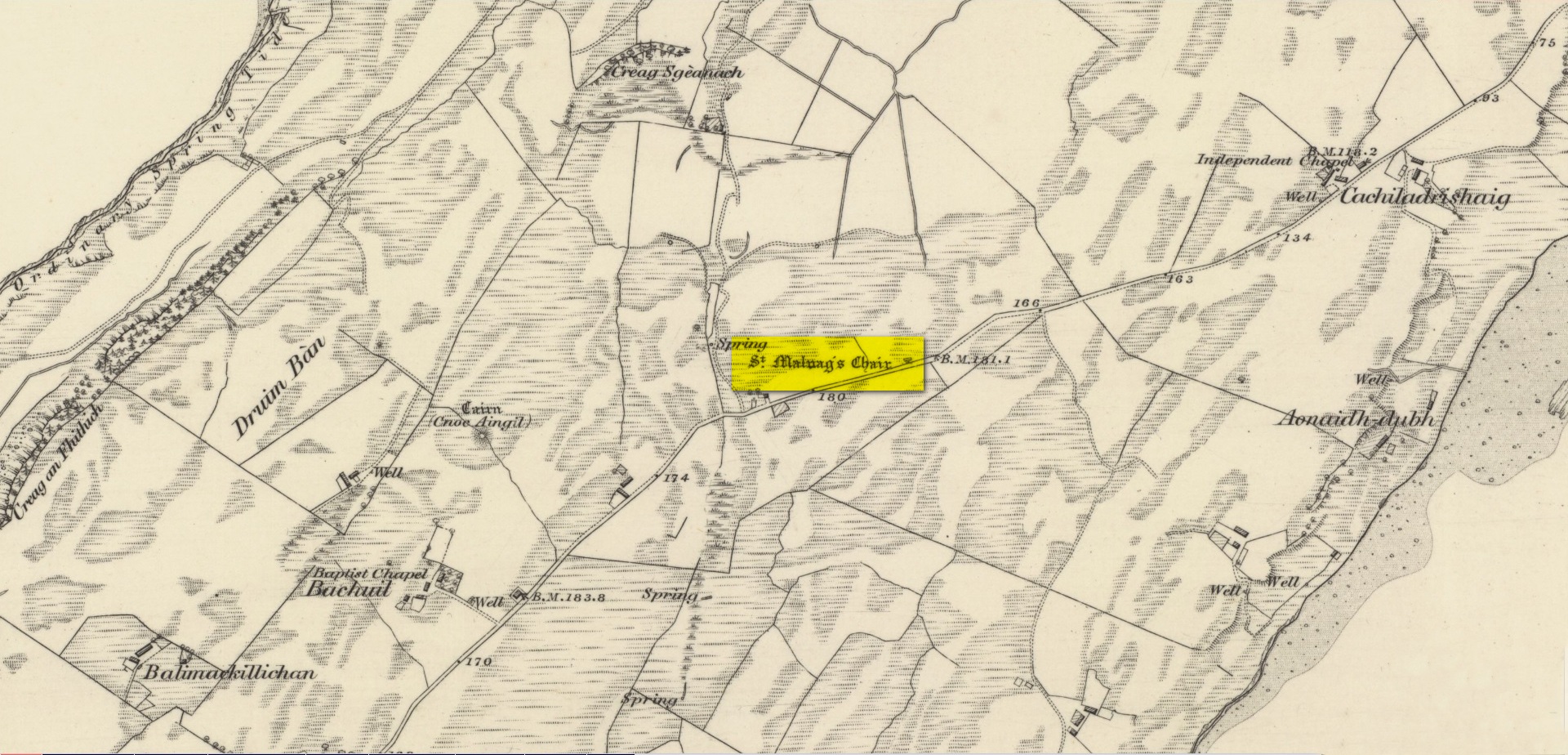
Site shown on 1875 map
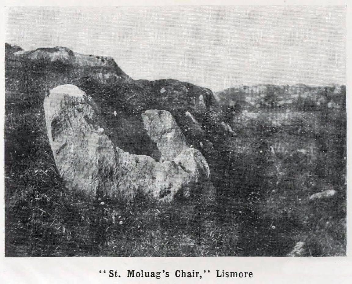
St Moluag, a contemporary of the renowned St Columba, was a 6th century Irish saint who came to reside on Lismore—“the sacred isle of the western Picts”—and here taught the early christian doctrines, fused with indigenous animistic traditions. He used sites of Nature as places of reflection and meditation and this chair-shaped boulder came to be a place renowned as one of his ritual sites, not far from his church. It was described in Frank Knight’s (1933) huge work as possessing healing properties:
“To sit in it used to be considered a sovereign remedy for rheumatism.”
The site was highlighted on the earliest Ordnance Survey map of the island and its lore was remembered by local people of the time. The chair had wider ‘arms’ until the beginning of the 20th century when in widening the road, they were accidentally broken off by one of the workmen.
References:
Knight, G.A. Frank, Archaeological Light on the Early Christianizing of Scotland – volume 1, James Clark: London 1933.
Acknowledgements:Huge thanks for use of the Ordnance Survey map in this site profile, reproduced with the kind permission of the National Library of Scotland.
On the west-side of the River Spey from Fochabers, follow the road-signs taking you south on the B9015, and near Inchberry is a tiny road on your right (careful not to miss it). Go along here to the end of the long straight road and turn right, down the track. When you reach the trees, bear left along the track to St Mary’s, Orton, marked “Private road”. 🙂 Parking is limited to one car only but very quiet.
Archaeology & History
St Mary’s Well, Inchberry (21st Century Pict)
Set in a stunning location next to the river Spey with a magnificent view of Ben Aigan to the south, St Mary’s Holy Well and Pool is easy to find behind the Chapel / Mausoleum wall, dedicated to the Duff Family. There is a small stone basin in the wall which may have been the Chapel font. At the time of my visit the weather has been dry and sunny for some time. The pool below the iron grate has been recently cleared of leaves before my visit, with no standing water but the stones on the bottom of the pool looked damp. And with the cemetery above and behind the wall, perhaps it was for the better.
It was clear and running, said J.F.S. Gordon (1880) at the end of the 1700s, but when he came to write about it the flow “has ceased for many years, and is now only a feeble, filthy, stagnant Driblet for the use of cattle.” Pilgrimages were made here on the first Sunday in May, and water collected from the site was kept for a year, in return for an offering (usually a stone or other inanimate object) that enabled the magickal spirit of the well to enact cures.
Folklore
A site described by Watson (1868) as being “long held in superstitious reverence”, the well was said to cure whooping cough, eye problems and joint conditions. It had thoroughly un-christian shennanigans practised here by local folk, much to the consternation of the usual culprits! Visited extensively by people from far and wide, Mr & Mrs Morris (1981) told,
(21st Century Pict)
“The visits displeased the Kirk and there were various summonses to the Session for “going supersticiously to a Vell at Speyside” and of persons who “kneillit about the chappell and drank the water.” The minister at Ruthven reported that a large number had gone to the chapel well “thrie Saturdays before Lambas and thrie efter called the six silie Saturdayes, and that the conventions wer on the night or before day in the morning.” And “quhairas zierlie about Lambnes, the ignorantes repaired to ane wel at this kirk, called Our Ladie Wel, superstitiouslie, and kneeled about the said kirk, it is reportit that the evil is removed.” This may be the well associated with the White Witch, Dame Aliset, who cured a fairy child with simples and the well water.”
References:
Bord, Janet, Holy Wells in Britain – A Guide, HOAP: Wymeswold 2008.
Watson, J.& W., Morayshire Described, Russell & Watson: Elgin 1868.
Acknowledgements:Huge thanks for use of the Ordnance Survey map in this site profile, reproduced with the kind permission of the National Library of Scotland.
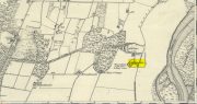
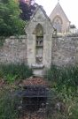
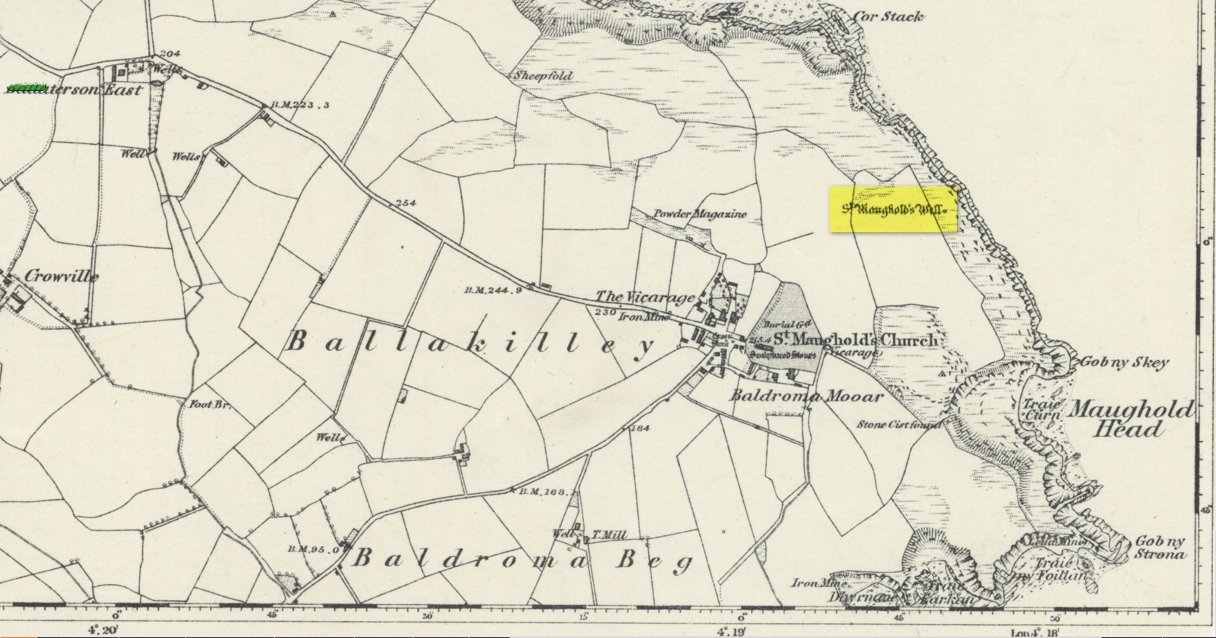
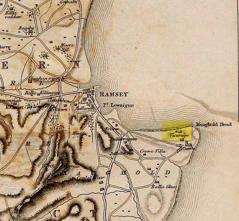
St. Maughold’s Well—also called Chibbyr Vaghal—is found on the northeast side of the headland on the cliff face about a hundred feet above the sea, a quarter mile from the St. Maughold’s church. It was a pilgrimage site which people visited on the dates of November 15 and July 31.
“…Beneath the head, under some moss clad rocks, is a deep spring, formerly much celebrated for its supposed medicinal virtues.” – George Jefferson, 1840
St Maughold’s on 1870 map‘Well’ on the 1836 map
Its medicinal properties are of great repute and was resorted to by many on account of its sanctity by crowds of pilgrims. The well was traditionally visited on the first Sunday in August, being the first Sunday after the Saint ‘s principal feast day, July 31 (significant in the Celtic calendar), but the devotions here have their origins in pre-christian times. The principal benefit at the well was a cure for sore eyes. After bathing the eyes or drinking the water it was/is customary to drop a coin, pin or button into it. Alternatively, a piece of cloth which had been used for bathing the eyes would be left by the well or on a nearby bush. As the cloth rotted, the ailment would be cured; while anyone who picked up the rags would himself receive the complaint associated with the offering; and to receive the full benefit of the well’s curative powers it should be visited on that first Sunday in August, and “while books were open in the church” — or in pre-reformation days, whilst Mass was being offered.
“…Where the spring gushes forth the rock has been hollowed into a small basin, and over it has been erected a simple shed of rough unhewn blocks of the rock immediately at hand. Hither the Saint is said to have resorted; nor is it altogether improbable that nearly fourteen hundred years ago at this very font he administered the baptismal rite. Certainly it was for many ages in great repute for its medicinal properties, and was resorted to on account of its sanctity by crowds of pilgrims from all parts. Nor is it yet forgotten.” – J.G. Cumming, 1848
“…A drink of its water, taken after resting in the saint’s chair close by, is supposed to be an unfailing cure for barrenness in women.” – A.W. Moore, 1890
Folklore
At Maughold churchyard above the well, ghostly whispers are said to be heard by the steps in the churchyard. This is interesting as when excavations were done here, the labourers found bones buried beneath the same steps. They were dug and exposed during the day and one worker who stayed in the church heard distant sounds, whispers and murmuring all around the church. When the bones were reinterred, the haunting stopped. (Bord & Bord 1985)
References:
Bord, Janet & Colin, Sacred Waters: Holy Wells and Water Lore in Britain and Ireland, Granada: London 1985.
Cumming, J.G., The Isle of Man: Its History, Physical and Ecclesiastical, J. van Voorst: London 1848.
Hall, John, “Earth Mysteries of the Isle of Man,” in Earth, no.17, 1990.
Moore, A.W., The Surnames and Place-Names of the Isle of Man, Elliot Stock: London 1890.
Jefferson, George, Jefferson’s Isle of Man, G. Jefferson: Douglas 1840.
Radcliffe, William & Constance, A History of Kirk Maughold, Manx Museum: Douglas 1979.
Acknowledgements:Huge thanks for use of the Ordnance Survey map in this site profile, reproduced with the kind permission of the National Library of Scotland.
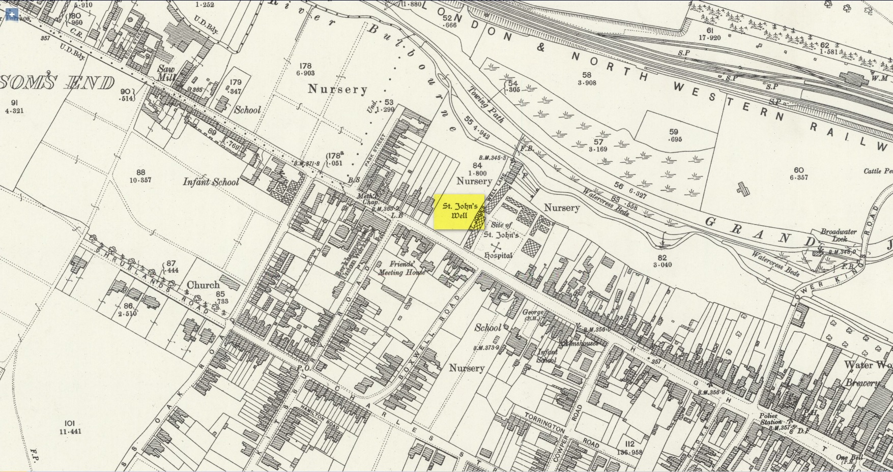
Holy Well (destroyed): OS Grid Reference – SP 9848 0822
Also Known as:
St. James’ Well
Archaeology & History
Site shown on 1897 map
Shown on the early Ordnance Survey maps of the town, Berkhamsted’s holy well was a place of some renown in bygone centuries. Today it is barely remembered. It was initially dedicated to St. James, as it was associated with a chapel dedicated to that saint close by, but it had a change of name when the legendary Brotherhood of St. John the Baptist became the new caretakers, so to speak. As a result of this, its history can be a little confusing to some folk!
In the late 12th century, pagan worship at this site came to the attention of Hugh of Grenoble, the Bishop of Lincoln, who visited the place to stop local folk performing their animistic practices (although the exact nature of such rites were not described, sadly). It didn’t work, obviously; as once the bonkers bishop had gone, local folk would have continued in their old ways, no doubt wondering who the hell the odd incomer had been who was telling them to stop doing what they had always done here at the cost of no one. And so the waters continued to be used under the mythic cover of old St James—for the time being at least.
The well later became a centre of pilgrimage and and a hospital was been built close by dedicated to St James, where leprosy was treated and the curative waters from this well were used. St James’ Day was July 25 and an annual fair was held in Berkhamsted thanks to a Royal Charter of James I in 1619. Hertfordshire traditions relating to St James Day are described in Miss Jones-Baker’s (1974) fine survey on the customs of the county. But change was a-coming when a local monk had a dream that the waters of this “pagan spring” needed to be blessed and dedicated to the virtues of St. John the Evangelist and a shrine built where pilgrims could worship and be healed. And as Jones-Baker (1977) told us,
“The water of St John’s Well were thought to cure a variety of diseases; among these leprosy and scrofula (the King’s Evil) as well as sore eyes. There was also a persistent belief that clothing washed in its waters would impart good health to the wearers.”
In the period when the Protestant Reformation occurred, the well and its immediate surrounds apparently became derelict and overgrown. The Old Ways returned and local folk began to visit the waters again at night and the animistic rituals that would have been taken to other secret places returned to St. John’s Well. In this period a local physician, a Dr. Woodhouse, used the sacred waters as part of magickal rites to exorcise evil spirits!
In spite of the local authorities declaring in 1865 that the water was “unfit for drinking”, local folk later told otherwise. Its waters were still being used in the 20th century and its traditions no doubt retained. As the local writer Dora Fry (1954) told us:
“The families dwelling in the cottages at the Bulbourne end of the lane, just below St John’s Spring, were all remarkably healthy… Some time after the town got its first waterworks (and) the local authorities declared that the well’s water was to be used only for the gardens… but I remember as a child drinking the water from the main spring and its coolness and freshness were delectable on a hot summer afternoon.”
The well was still visible up until the 1930s, when its waters ran down a shallow channel along St John Well’s Lane, but then a shop was built above the site and the well has been lost forever.
References:
Bord, Janet & Colin, Sacred Waters, Granada: London 1985.
Acknowledgements:Huge thanks for use of the Ordnance Survey map in this site profile, reproduced with the kind permission of the National Library of Scotland.
Holy Well (destroyed): OS Grid Reference – NT 2611 7600
Also Known as:
Bonnington Mineral Well
Archaeology & History
Site shown on 1862 map
If we’d have lived 200 years ago and walked several miles downstream from St Bernard’s Well on the Water of Leith, we would have eventually come across this little-known sacred site, sadly destroyed in the 19th century. It was shown on the earliest OS-map on the south-side of the river, enclosed in a small square building with what looks like two entrances, and what appears to be a covering of the spring on the southeast side. Marked as a chalybeate, or iron-bearing well, this would have obviously have had repute amongst local people and would have worked as a tonic or pick-me-up, aswell as fortifying the blood and a having a host of other benefits.
The Ordnance Survey lads wrote short notes about St. Cuthbert’s Well in the Name Book of 1852-53, where they told:
“A Well Situated at Bonnington. Supposed to have been dedicated to St Cuthbert; about 34 years ago the proprietor repaired the well and at the same time erected a house over it, and fitted it up for Visitors who are charged one penny for a drink. The Water of the well has been analysed by Professor Jameson and Doctor Turner and it was found to Contain Salts of Iron; Soda, magnesia and Lime, also Iodine under the form of Hydrisdate of Potash.”
About the same time as Jameson & Turner’s analysis of St. Cuthbert’s waters, one Dr Edward Schweitzer (1845) wrote one of the most detailed chemical essays on wells, ever!—using Bonnington’s holy well as his primary focus. A near-thirty-page essay found that, along with an excess of iron, the medicinal aspects of the waters were due to the following compounds found, per grains, in each pint of water:
Sulphate of Potassa — 2.46554 gr
Sulphate of Soda — 1.51227 gr
Sulphate of Lime — 6.28816 gr
Iodide of Sodium — 0.00728 gr
Bromide of Sodium — 0.07886 gr
Chloride of Ammonium — 9.49939 gr
Chloride of Sodium — 3.82963 gr
Chloride of Magnesium — 3.12017 gr
Nitrate of Soda — 2.02154 gr
Carbonate of Magnesia — 1.70443 gr
Proto-Carbonate of Iron — 0.05807 gr
Proto-Carbonate of Manganese — 0.01535 gr
Ammonia (united to organic matter) — 0.42285 gr
Alumina — 0.02245 gr
Silica — 0.18651 gr
In 1837, a Mr Robert Fergusson was known to be “the keeper of the Mineral Well, Bonnington,” but much of its traditions and history have fallen outside of memory. The site was soon to become another mid-Victorian ‘Spa Well’, where local people would have to pay for water they had always used as Nature intended. In truth, the waters and its well-house were to become a place where the rich Industrialists could heal their infirm mind-bodies, hoping that the destitution they lacked emotionally and spiritually would be washed away in the sacred waters. But it didn’t last long! What little is known about it historically was best described in John Russel’s (1933) essay on Bonnington in the Old Edinburgh Club journal. He wrote:
“Just where the Bonnington mill lade joins the Water of Leith once flowed St. Cuthbert’s Well, an ancient spring named after the patron saint of the once extensive parish of St. Cuthbert’s, and like the now forgotten mineral well of St. Leonard’s near Powderhall, a relic of a superstitious age. As to when this well was so designated history is silent but it was probably before 1606, when the Leith portions of Bonnington, Pilrig and Warriston were, by the Scots Parliament, included in the Parish of North Leith…
“In May, 1750 St. Cuthbert’s Well was found to be possessed of medicinal properties. The Scots Magazine of that year refers to many persons frequenting it. The Well formed part of a building which included a pump room and a reading room. From advertisements in the periodicals of 1819 we learn that it was open from 6 o’clock in the morning and that newspapers were to be found on the table all day. The tenant also issued handbills headed “St. Cuthbert’s Mineral Well, Bonnington”, giving a chemical analysis of the water and a list of the ailments for which it had been found beneficial. The Well disappeared with the re-construction of Haig’s Distillery in 1857. It now lies beneath the buildings immediately west of the chimney stack of Messrs John Inglis and Sons.”
St. Cuthbert’s feast day was March 20 (Spring Equinox) and September 4.
A half-mile southwest of here could once be seen the waters of St. Leonard’s Well, which Ruth & Frank Morris (1982) erroneously thought to have been this Well of St. Cuthbert.
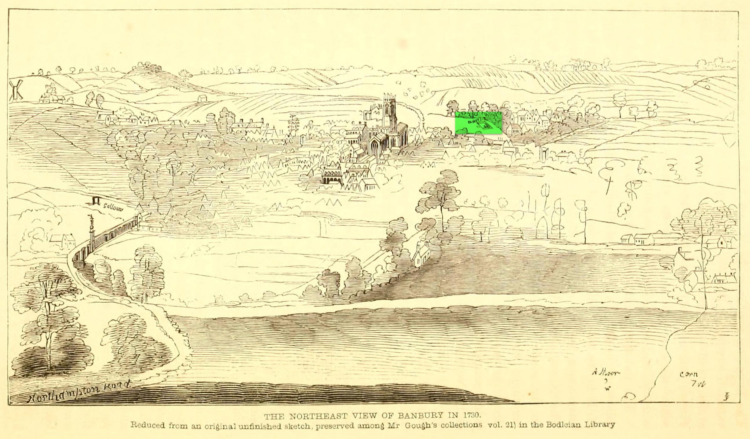
Holy Well (destroyed): OS Grid Reference – SP 4506 4055
Archaeology & History
Well highlighted, in 1730
The holy well of Banbury seems to have been destroyed sometime in the second-half of the 19th century, when the industrialists built over the area. When the historian Alfred Beesley (1841) wrote about it, the waters were still running. He told it to be, “a chalybeate spring, well-known and still often visited, situated on the west side of the town, a little north of the footway leading to North Newington.”
The footpath is obviously long gone—as is the well. It’s iron-bearing (chalybeate) properties would have given the waters good fortifying properties, perhaps of some renown to local people yet, according to Mr Beesley, it was a slow-flowing spring. In his brief history of the site, he also gave us the results of a chemical examination of its healing waters, telling us:
“This is called St. Stephen’s Well in a plan of Sir John Cope’s property at Banbury made in 1764. It also appears prominently as “A Well ” in an unfinished view of Banbury made in 1730 (illustrated above)….
The water of this spring is perfectly clear and colourless, having a brisk and slightly chalybeate taste. The stone channel is coated with a light red deposit, and a scum of the same colour appears on the water in parts where stagnant. The spring discharges from half a gallon to one gallon in a minute. In 32 oz. of the water at 60° are,
Carbonic Acid gas, 5 cubic inches
Hydrochlorate Magnesia, 0.21 grains.
Chloride Sodium or common Salt, 0.54
Sulphate Lime, 1.5
Carbonate Lime, 3.8
Protoxide Iron, 0.024
Silica a trace
Total weight of solid contents – 6.074″
Folklore
St. Stephen is an odd character. His annual celebration or feast day in Britain is December 26. (in eastern countries it’s a day later) Rites connected to this character are decidedly heathen in nature. From the 10th century, in England, St Stephen’s Day has been inexorably intertwined with horses, bleeding them on his feast days, apparently for their own health. Water blessed by priests on this day would be kept for the year and used as a medicine for horses during that time. Also on this day, young lads would “hunt the wren” and, once caught, impale it on top of a long pole and take it from house to house. Despite this curious motif being a puzzle to folklore students, Mircea Eliade (1964) explained how this symbolism is extremely archaic and “the bird perched on a stick is a frequent symbol in shamanic circles.”
Eliade, Mircea, Shamanism – Archaic Techniques of Ecstasy, Princeton University Press 1964.
Harte, Jeremy, English Holy Wells – volume 2, Heart of Albion press: Wymeswold 2008.
Johnson, William P., The History of Banbury, G. Walford: Banbury 1860.
Acknowledgements:Huge thanks for use of the Ordnance Survey map in this site profile, reproduced with the kind permission of the National Library of Scotland.