Cup-and-Ring Stone (lost): OS Grid Reference – NT 98491 28424
Archaeology & History
Highburn House C&R, 2015
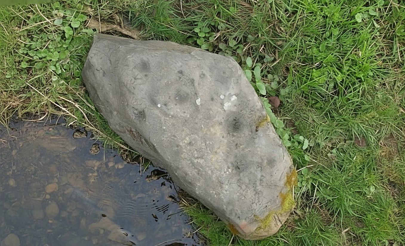
This carving was rediscovered by rock art explorer Jan Broewer in September, 2007, a few hundred yards out of Wooler on the way to Akeld and Kirknewton, in the field on the right-hand side of the road, on the embankment just a few inches above the waters of the High Burn. On a recent visit here by Tom Cleland and I, despite us rummaging amidst the gorse and other herbage all along the edge of the waters, we were unable to locate the carving and presume that it has either been destroyed or re-housed in someone’s garden, living a more comfortable life. We certainly hope it’s the latter!
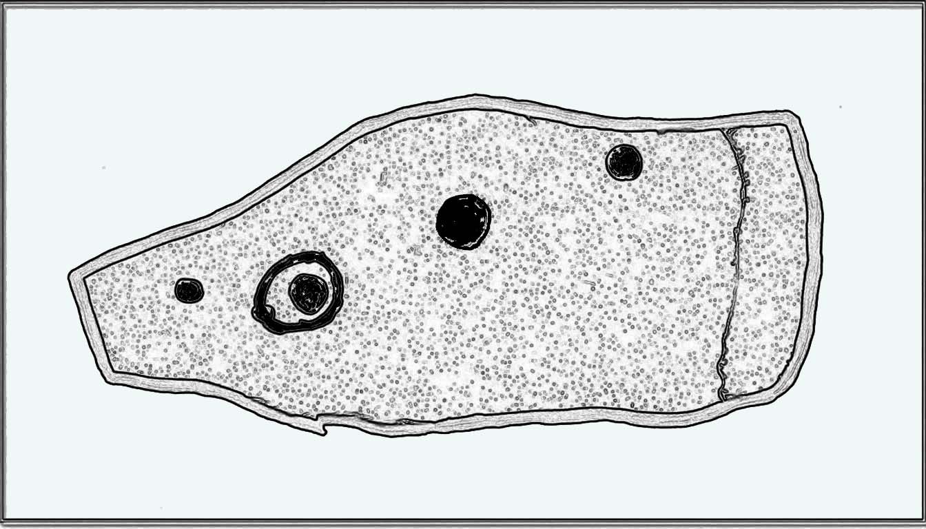
Sketch of the designHome of the lost carving
It’s design is nothing special: merely a singular, albeit scruffy cup-and-ring, with two other distinct pecked cup-marks and, possibly, a third shallow one just to the side of the cup-and-ring (but this is, in my opinion, highly suspect). The stone was obviously not in its original position when Jan first found it, and would seem to have come originally from the slope above the stream where a number of earthfast stones can be found. The numerous scratches across its surface shows that it’s been hit a few times by some (probably) metallic objects, or perhaps horses hooves, thus dislodging it from the slope above and rolling into the spot where Jan found it. Anyhow, we presently don’t know where it is or what’s become of it. Does anyone in Wooler know where it’s living?
Acknowledgements: Huge thanks to Pete Chattaway for use of his photo; and to Tom Cleland for helping the search party!
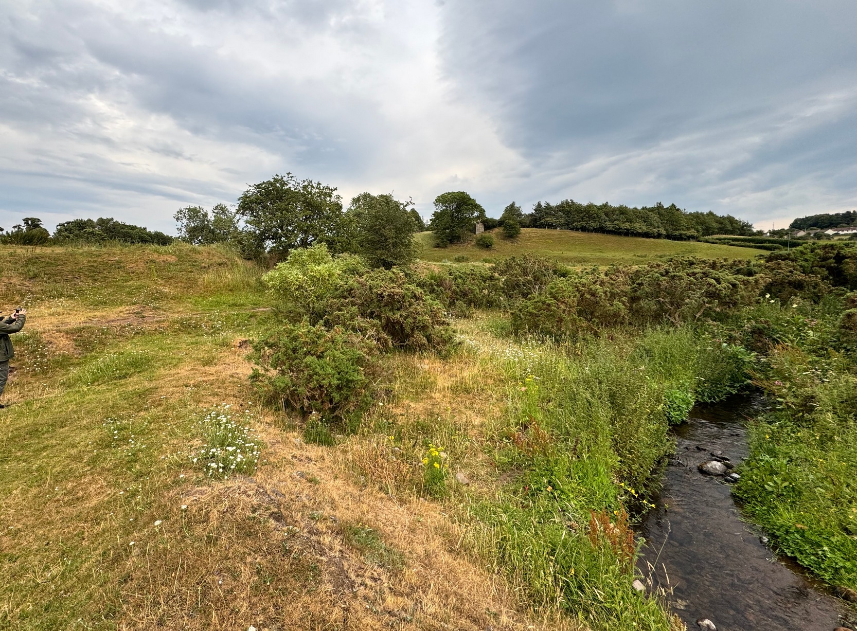
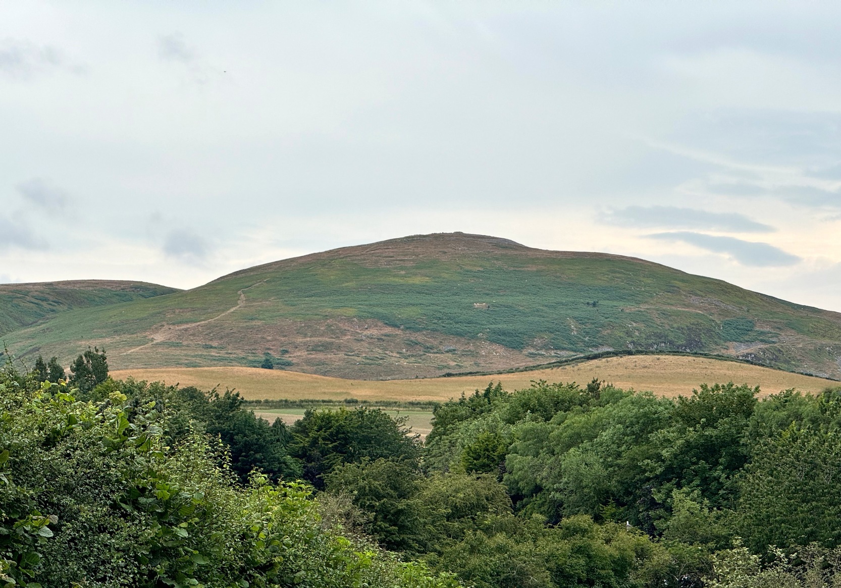
On our first visit to Wooler, in seeking out (and not finding!) a cup-and-ring stone alongside the old burn just on the northern side of town, we looked up at the ridged hillside of Humbleton Hill ahead of us and proclaimed, something along the lines of: “That look’s like something man-made up there!” And so it turned out. But the heat of the summer kept us from ascending the hill, so just an old account must be penned, from the quill of the great rock art pioneer George Tate (Home & Tate 1857) who, following a visit here in May 1852 with various members of the Berwickshire Natural History Society, penned the following:
“On the north side of Humbleton burn is a conical hill truncated at the top, and rising abruptly about 100 feet above the level of the burn; the slope, though considerable, is less steep on the other sides. This was one of the strongholds of the ancient Hritons. A rampier (now obliterated) ran around that part of the hill not protected by the ravine of the burn. The summit of the hill is 180 yards in circumference, having a hollow in the centre of the area; it is surrounded by a rampier of stone and earth, which is yet in some parts 3 feet high. This entrenchment is commonly called ‘The Cup and Saucer Camp’.”
The Hillfort itself is in very good condition overall, is very extensive and has a very clear series of walled ramparts all round the summit of the hill. It has yet to be excavated.
Folklore
The local folk-name given to this old hillfort—the Cup and Saucer Camp—related to the shape and lay-out of the enclosure, and with it, the tradition that the chiefs of the tribe inhabited the topmost enclosed section of the hillfort: the so-called ‘Cup’; whilst the tribal familes inhabited the realms immmediately outside and below the chief’s domain: the so-called surrounding ‘Saucer’. On the northern edges of the outer ‘saucer’ walls are several ‘hut circles’ (for want of a better term), that would house people, or their animals—or both.
References:
Home, Robert & Tate, G., “Address to the Members at the Anniversary Meeting, held at Embleton, Sept 8, 1852,” in Proceedings of the Berwickshire Naturalists’ Club, volume 3, 1857.
We took the B6348 road up east, from Wooler, turning left 2 miles up and crossing the small river bridge, going past Weetwood Hall where the road bends to the right and goes uphill for about a mile where, just before West Horton farm, there’s a a dirt-track on your left. 200 hards up, walk past the farm up and along the dead straight track for another 400 yards until you hit the field. Diagonally ahead of you (NW) less than 100 yards away, a small hillock rises in the field where a large metal animal feed-trough sits. Once there, the slope to your right (east) is where the stone lives. If you potter about you’ll find it.
Archaeology & History
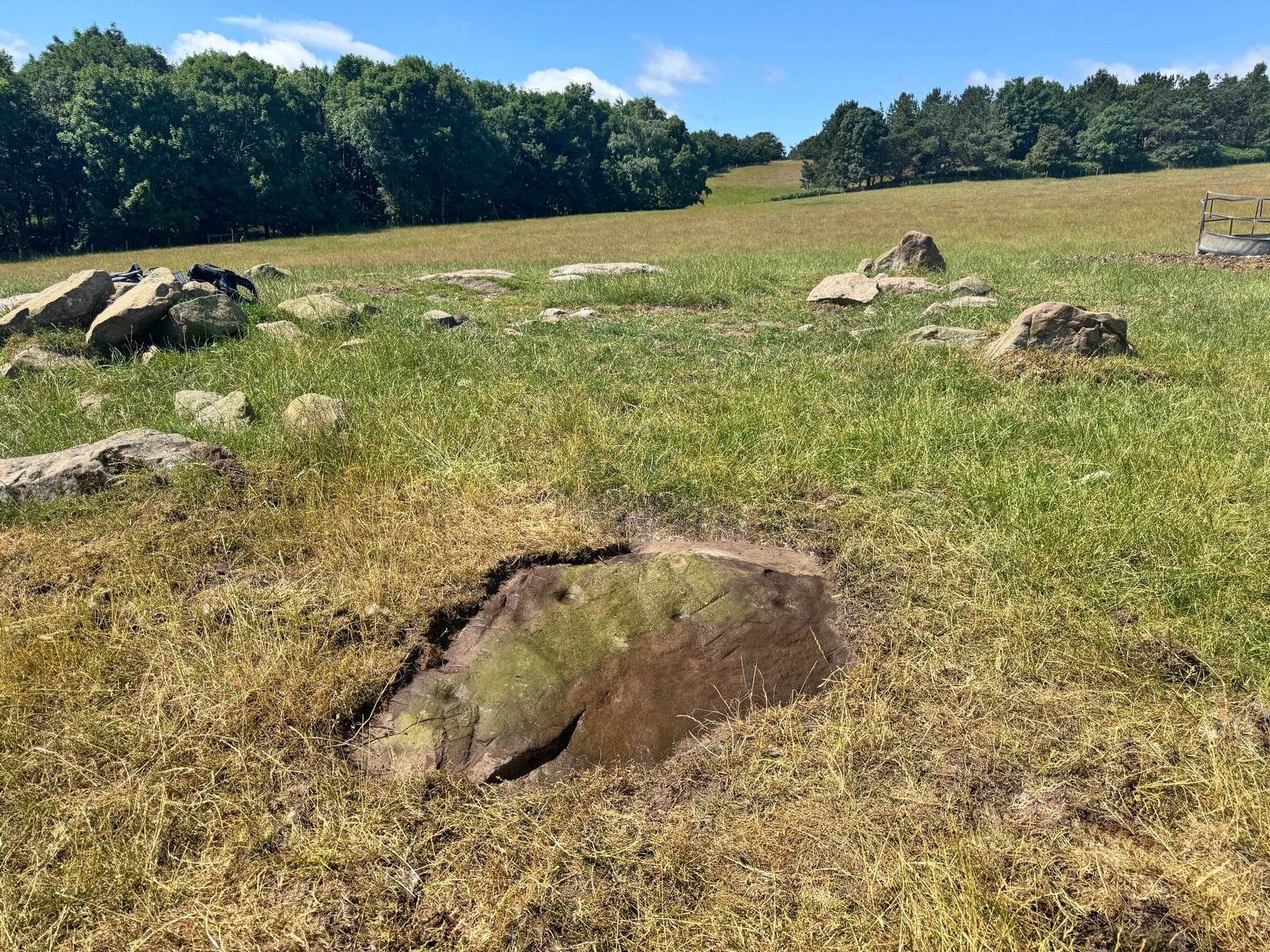
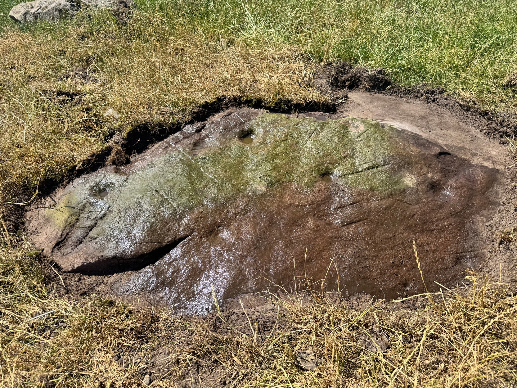
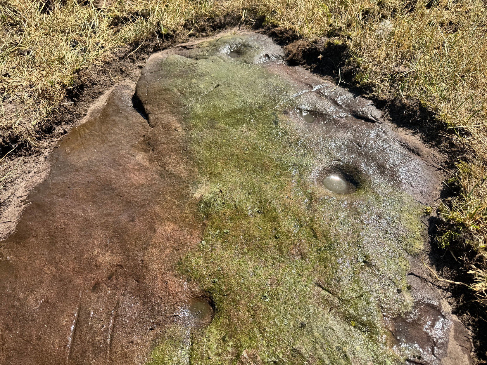
On a visit to the impressive West Horton carvings on one of the searing hot days recently, Tom Cleland and I thought to check on an otherwise unimpressive petroglyph on a rocky rise of land before heading to the beauties 250 yards northwest of here. The covering soil around a scatter of earthfast rocks on this rise in the land had been eroded by cattle and on one of them we noted what seemed to be a distinct cup-marking. And, as happens when you look closer, a more expansive design came into being.
Main design from aboveFaint ring round the cup
On the east-sloping-face of this rock are between six and seven cup-marks, most of them quite distinct. The topmost of the cups has a faint incomplete ring round it which you can just make out in a couple of the photos. It seemed that there was another even fainter ring around one of the other cups, but on the day we visited this the heat was taking its toll of me and I could only stand a short time before we had to move, so we left without getting any good images of the other ring.
More recent cup-marks
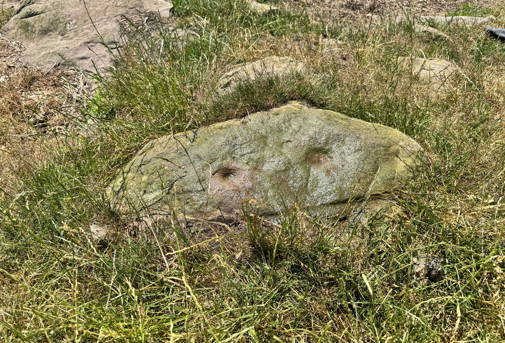
It’s more then likely that other unrecorded carvings are hiding beneath the soil which, no doubt, the cattle will slowly help uncover as the years go by. 🙂 A little further up the slope from here, approaching the West Horton (1b) carving, a small oval-shaped rock has what looks like a single cup-mark on it and another, more recent marking at its side. This impression is likely due to an incision made by the metal legs of one of the animal feeders and is unlikely to be prehistoric.
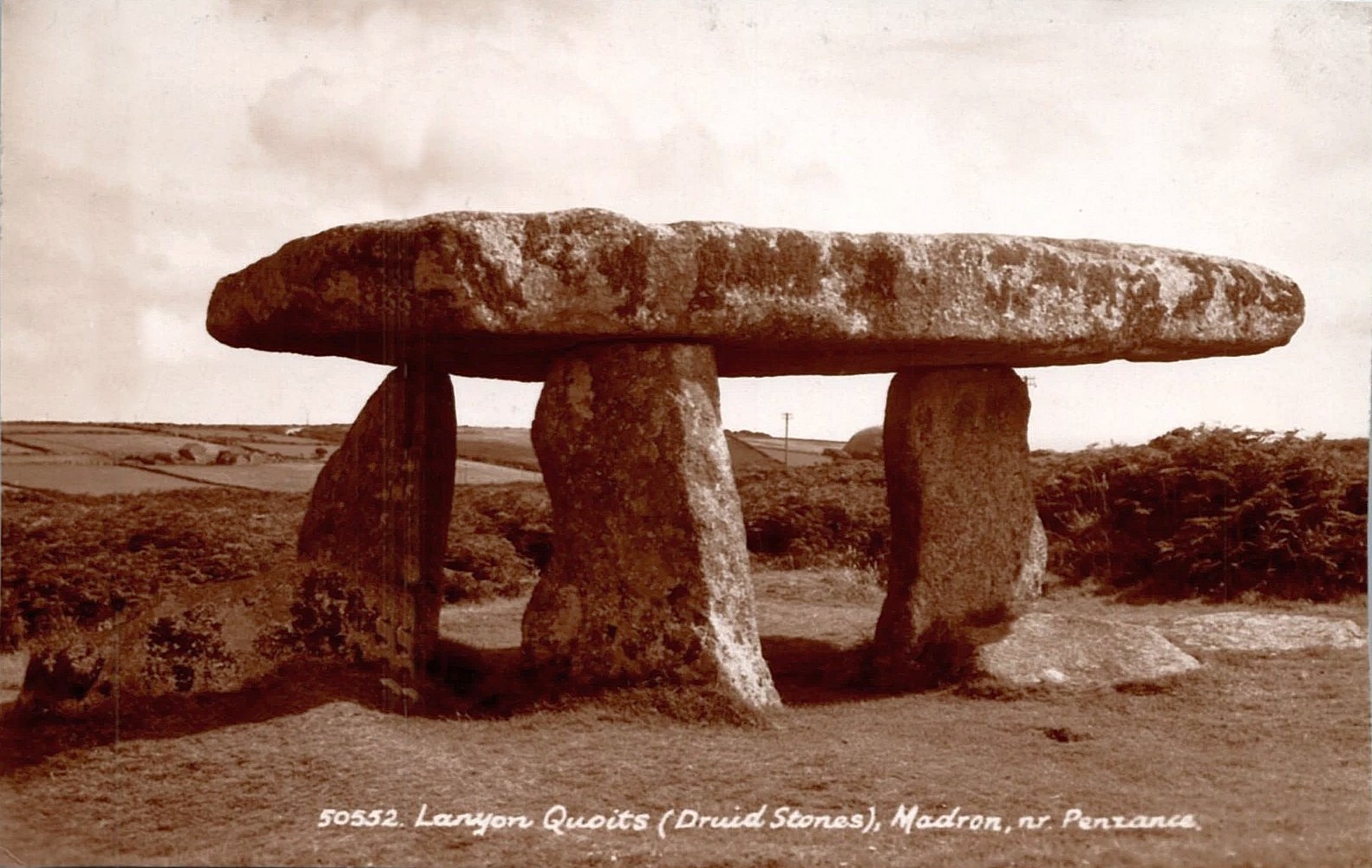
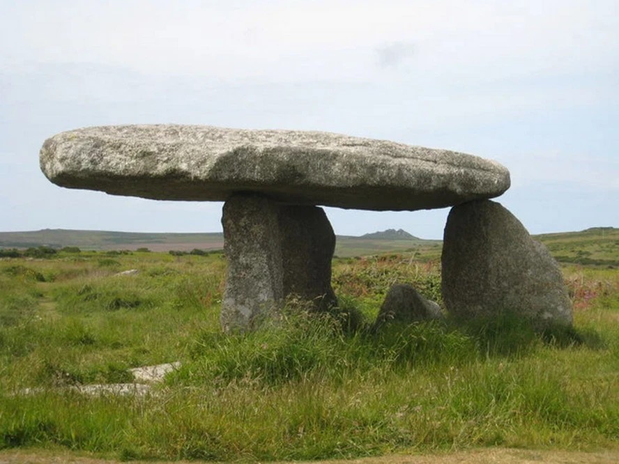
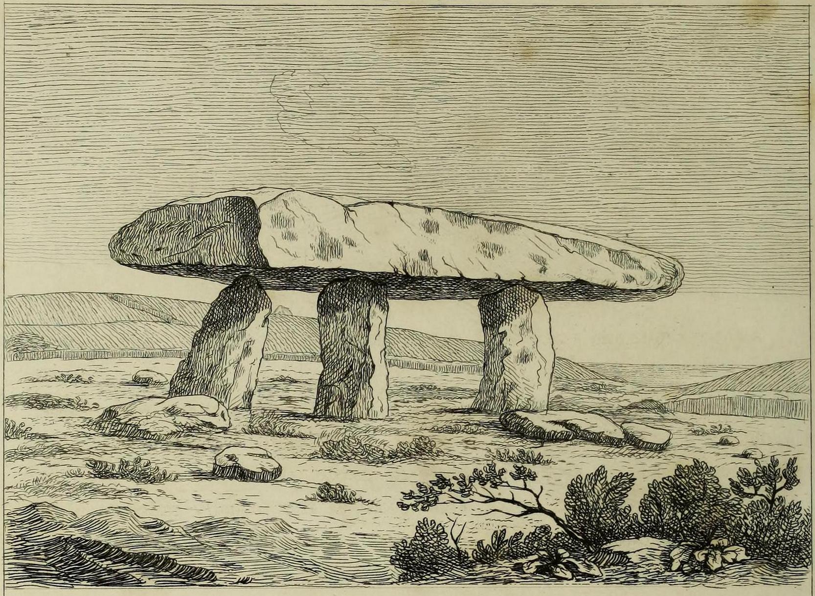
William Borlase (1769), in his revised classic on the megaliths & antiquities of Cornwall, wrote:
“Since we are now considering these Stone-monuments, there is a very singular Monument in the Parish of Madern (Cornwall) which in this place, will naturally offer itself to our enquiry. In the Tenement of Lanyon stand three Stones-erect on a triangular Plan. The shape, size, distance and bearing, will best be discerned from the plan and elevation of them…
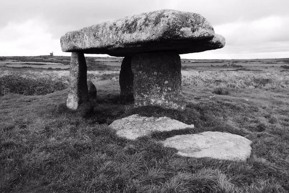
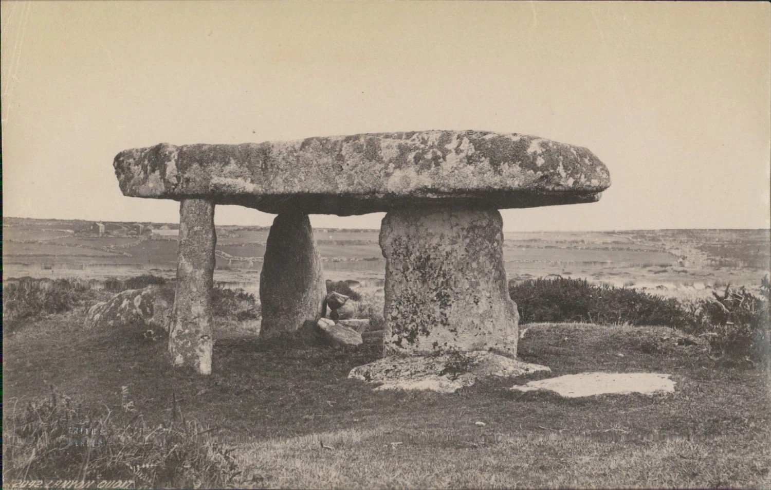
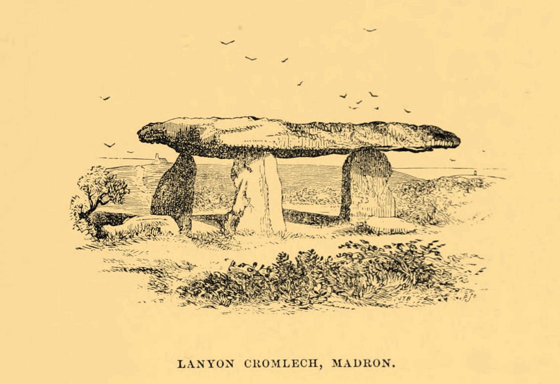
“The length of the area described by the supporters of Lanyon Quoit is seven feet; but it does not ſtand East and West, as at Molfra, but North and South… There is no Kist-vaen, that is, no area marked out by Side Stones, under this Quoit, which is more than 47 feet in girt, nineteen feet long; its thickness in the middle, on the Eastern edge, is sixteen inches, at each end not so much, but at the Western edge this Quoit is two feet thick. The two chief supporters…do not stand at right angles with the front line, as in other Cromlehs, but obliquely, being forced from their original position, as I imagine, by the weight of this Quoit, which is also so high that a man can fit on horseback under it. Under this Quoit I caused to be sunk a pit of four feet and half deep, and found it all black earth that had been moved, and should have sunk still deeper, but that the Gentleman in whose ground it is, told me, that a few years before, the whole cavity had been opened (on account of some dream) to the full depth of six feet, and then the faster appeared, and they dug no deeper; that the cavity was in the shape of a grave, and had been rifled more than once, but that nothing was found more than ordinary. This Cromleh stands on a low bank of earth, not two feet higher than the adjacent soil, about 20 feet wide, and 70 long, running North and South: at the South end has many rough Stones, some pitched on end, in no order; yet not the natural furniture of the surface, but designedly put there; though, by the remains, it is difficult to say what their original poſition was. Wet N. W. there is a high stone about 80 yards distance. By the black earth thrown up in digging here, nothing is to be absolutely concluded, there having happened so many disturbances. By the pit being in the shape of a grave, and six feet deep, it is not improbable that a human body was interred here, and by the length of the bank, and the many disorderly stones at the South end, this should seem to have been a burial place for more than one person.”
William Borlase 1769 ground-planWilliam Borlase 1769 sketch
Antiquarian Notes
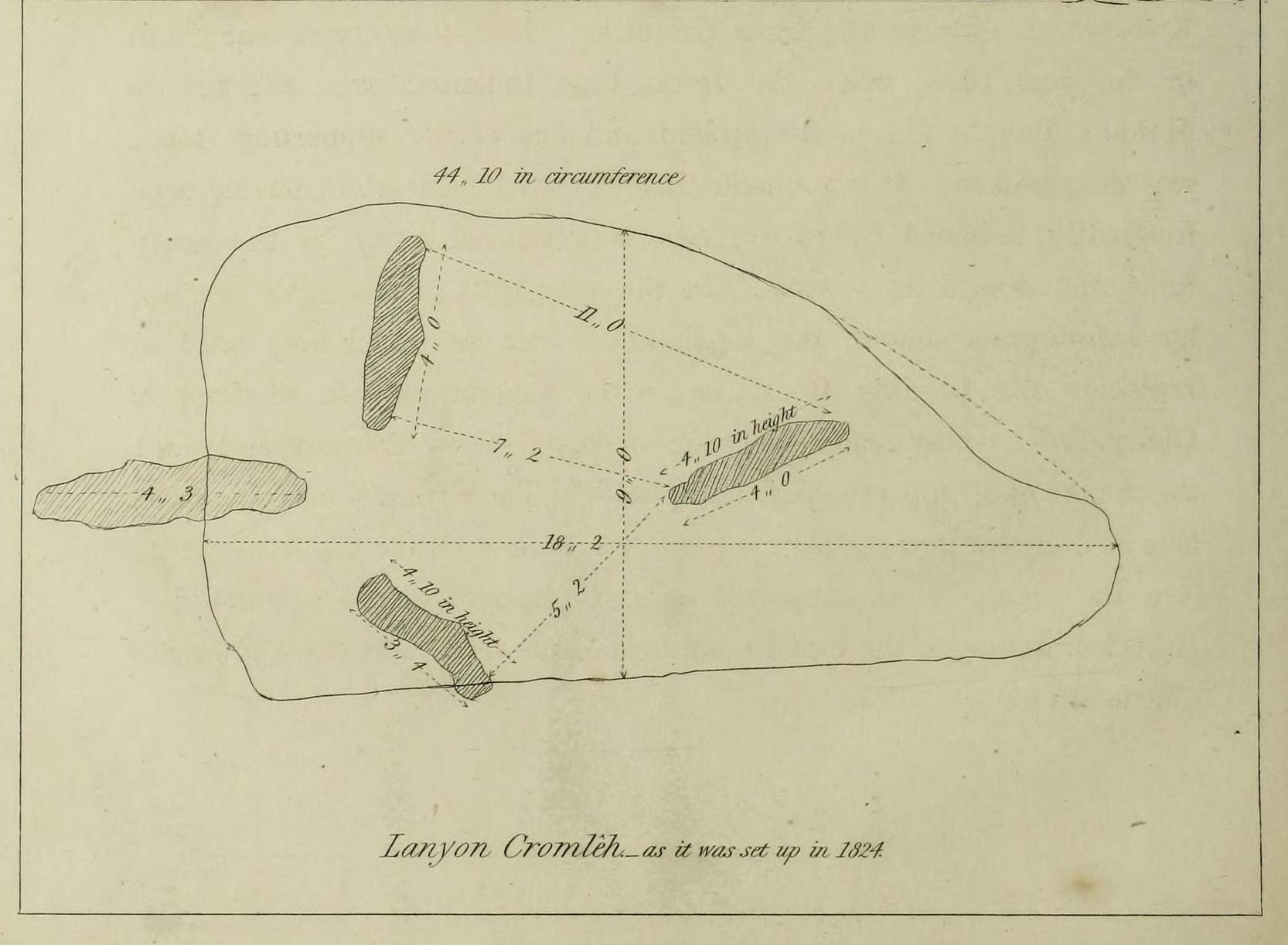
William Cotton, in 1827, told that:
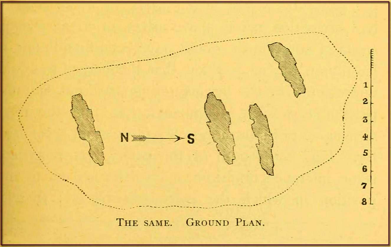
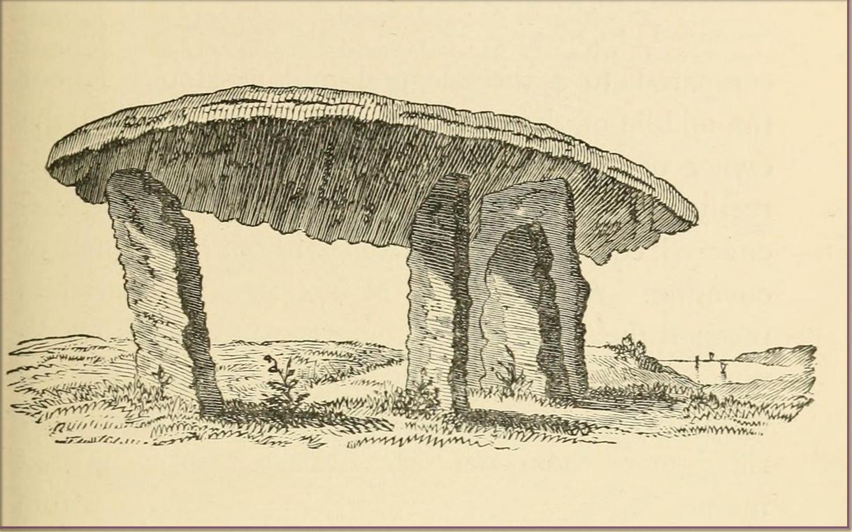
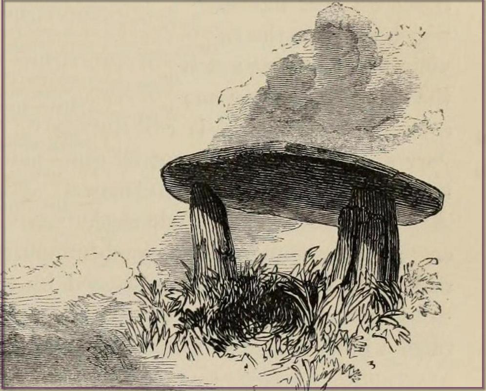
“About a mile and a half north of the church, in the parish of Maddern, and close to the road side, is Lanyon Cromleh, so called from the name of the estate on which it stands. The covering stone, which is nearly flat, and of a triangular figure, measures 44 feet 10 inches in circumference, 18 feet 2 inches in its greatest length, and 9 feet in width, and weighs 15 tons. This Quoit, as it is usually called, was originally supported on four upright stones, describing an open area 7 feet in length, north and south, but not forming an enclosed Kistvaen, like Molfra and Chun Cromlehs. During a very violent storm in the year 1815, when the Delhi East Indiaman was wrecked in Mount’s Bay, it fell to the ground, and one of the supporting stones was then broken. It is probable that the earth beneath it, having been frequently loosened by excavations, was washed away by the heavy rains, and caused its downfal. In the year 1824 it was again set up, by subscription among the inhabitants, with the machinery used in replacing the Logging Rock, under the superintendence of Captain Giddy, R.N., whose zealous exertions overcame every difficulty, and merit the thanks of all topographical antiquaries. The Cromleh now stands as firm as ever: in putting it up, a piece was broken off the top stone, at A, (see the plan). It is supported on three upright stones, each 4 feet 10 inches in height, the tops having been made level, and their positions a little altered.
“This view represents Lanyon Cromleh as it now stands, and differs from all the prints I have seen of it, — which have been uniformly copied from Dr. Borlase’s book, and do not, by any means, give a correct representation. The doctor says, in his time a man on horseback could ride under the incumbent stone — now, its height from the ground is only 4 feet 10 inches. The figures 1824, to mark the year when it was re-erected, have been rudely inscribed on one of the supporting stones.
“Dr. Borlase caused an excavation to be made under this Cromleh, as well as under the last mentioned, but without discovering any human bones ; he was led, however, to conclude, by the appearance of the earth, that a body had been interred there.”
Cotton’s 1827 sketch
Antiquarian Notes
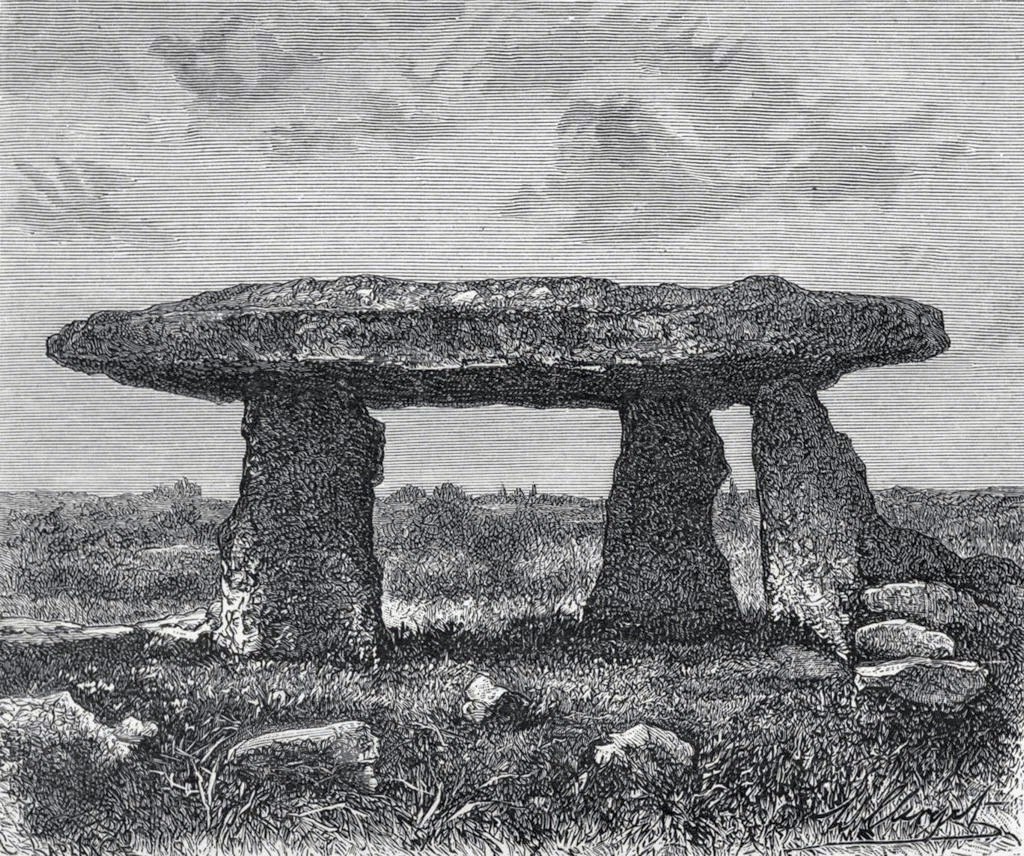
James Orchard Halliwell wrote, in 1861:
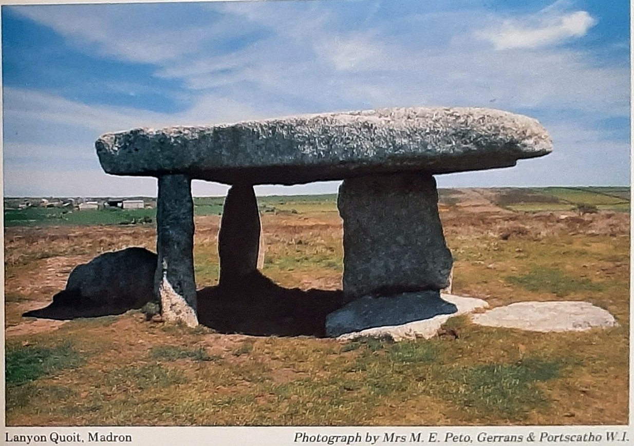
“At a distance of some five miles from Penzance, on the road from Madron to Morvah, near the road, on the right-hand side, is the Lanyon Quoit or Cromlech, a fine specimen, and perfect in all essential particulars. The best way of reaching it, if walking, is to take the path to the left in the fields after passing the Madron Union, and keep as nearly in a straight line as possible until the cromlech appears. It is situated in a conspicuous situation in the midst of a wild moor, and is interesting in its Titanic grandeur and vast antiquity. The top covering consists of an enormous flab of granite, supported by three upright unhewn blocks of stone, but near there are three fallen stones, one of which at least was certainly at one time one of the supporters. The dimensions of the cap-stone are thus given by Borlase: —
“This quoit is more than forty-seven feet in girt, and nineteen feet long ; its thickness in the middle on the eastern edge is sixteen inches, at each end not so much, but at the western edge it is two feet thick.”
This cromlech is sometimes called by the country people the Giant’s Quoit, and occasionally the Giant’s Table. My measurement made the covering-stone forty-fix feet in circumference, with a thickness varying from ten to eighteen inches. It is not improbable that the stone has been chipped off at one or two of the corners since the time of Borlase. Between the cromlech and the road are the remains of a stone and earth circular barrow about eighteen feet in diameter. There is an odd tradition that the first battle fought in England was decided in the locality of Lanyon Quoit.”
Blight, J.T., A Week at the Land’s End, Longmans Green: London 1861.
Borlase, William, Antiquities, Historical and Monumental, of the County of Cornwall, Bowyer & Nichols: London 1769.
Borlase, William Copeland, Nænia Cornubiæ, Longmans Green Reader: Truro 1872.
Colquhoun, Ithell, The Living Stones, Cornwall, Peter Owen: London 1957.
Cooke, Ian, Antiquities of West Cornwall – Guide 1, Cornwall Litho: Reduth 2002.
Halliwell, J.O., Rambles in Western Cornwall in the Footsteps of Giants, John Russel Smith: London 1861.
Jewitt, Llewellynn, Grave Mounds and their Contents, Groombridge: London 1870.
Redding, Cyrus, An Illustrated Itinerary of the County of Cornwall, How & Parsons: London 1842.
Russell, Vivien, West Penwith Survey, Cornwall Archaeological Society: Truro 1971.
Straffon, Cheryl, Megalithic Mysteries of Cornwall, Meyn Mamvro: Penzance 2004.
Acknowledgements: Huge thanks for use of the Ordnance Survey map in this site profile, reproduced with the kind permission of the National Library of Scotland.
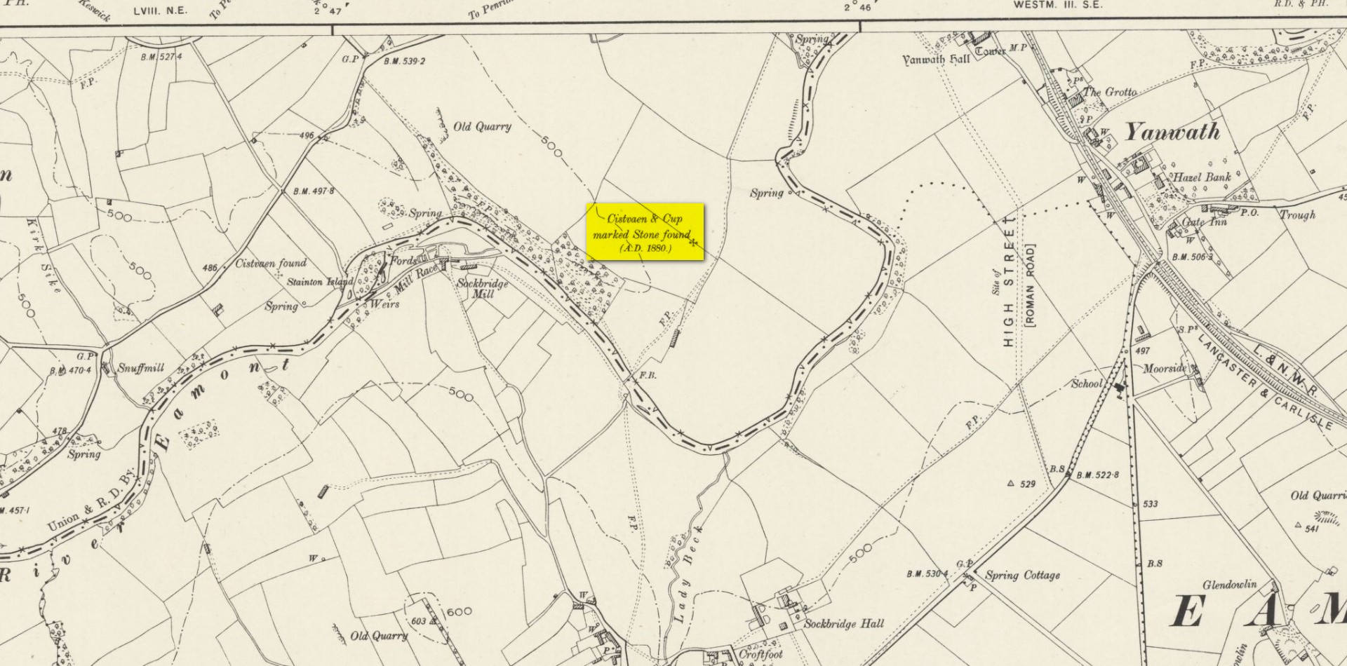
Cup-and-Ring Stone (lost): OS Grid Reference – NY 5019 2776
Also Known as:
Archaeology & History
Taylor’s 1883 sketch
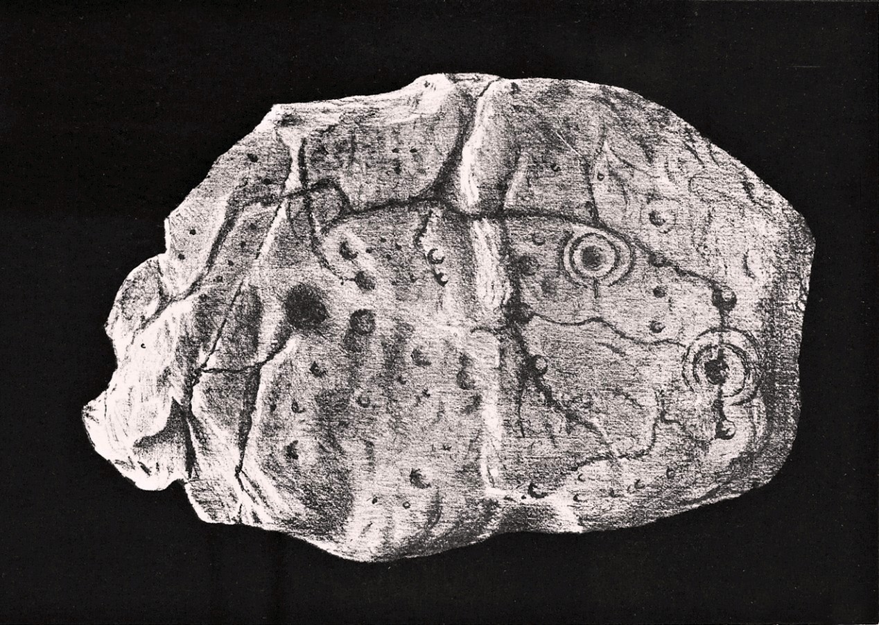
The geographical position of this site was shown on the 1897 Ordnance Survey map, albeit in the past tense as it had been destroyed not long after after being uncovered. Thankfully however, local antiquarian Mick Taylor (1882; 1883) did a damn good job recording what had been found here, and although he had remains of the stone in his possession shortly after it had been found, the carving has subsequently been lost. Thankfully Mr Taylor left us with a good drawing of the design (right).
Located a short distance west of the grand henges of Mayburgh and King Arthur’s Round Table, the carving was found some ten inches below the ground during work that was being done to lay some new fencing. The lads doing the work hit some stone and found it to be covered with a number of standard cup-and-ring motifs facing downwards. This carved stone, wrote Taylor (1882), was in fact “the cover of a kist-vaen”, a.k.a, prehistoric stone burial cist. He then proceeded to give a lengthy account of the site and the carving, telling:
Site shown on 1897 map
“There are traces of ancient occupancy, and vestiges of cairn structure still to be discerned on the hill-side on which it was found, but no barrow nor mound covered this particular grave. A space had been excavated for the interment dipping into the limestone rock to a depth of about 3 feet; the length of the grave was 4 feet, and the breadth about 3 feet 6 inches. Cobble stones had been used partially to line the cavity, but there was no flagging at the sides or bottom. The space was filled with blackish soil, amid which was a quantity of burnt bones, all in a fragmentary state. No implement nor shreds of pottery could be found, but there were several pieces of charcoal. It had evidently been an interment of cremated remains.
“The massive stone which formed the cover of the kistvaen I saw in situ immediately after its discovery.
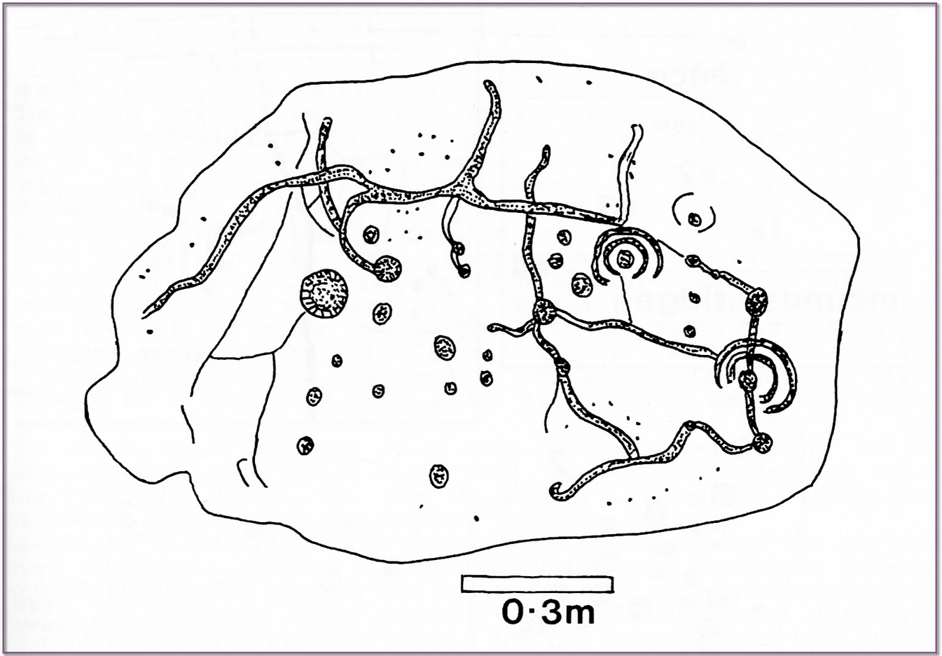
Beckensall’s impression of the design
“This stone is a natural slab of white freestone; it is of a broadish ovoid form, 5 feet 4 inches long, and at the centre 3 feet 6 inches broad, tapering towards each end; and it varies from 8 inches to 13 inches in thickness. The superior surface is rough and irregular, and scored in many places with marks of the ploughshare and harrows, which have passed over it in frequent cultivation. The interior surface, which was presented towards the grave, shows a fairly smooth cleavage, and on it were carved the sculptured markings which I shall describe.
“The slab, which is in my possession, was unfortunately broken in three or four pieces by the hammer of the workman, but I have put it together, and when viewed with a certain light when the shadows are deep, the sculpturings may be well made out, and appear to be arranged as follows: near the bottom there is a central cup deeply carved, about 3 inches in diameter; around this there are two concentric rings, somewhat faintly incised, the outermost of which has a diameter of 6 inches. From this central cup proceed two grooves 6 inches long, which bisect the concentric circles, and traverse in a straight line to join a similar cup on each side of the central one. From this line of cups three gutters meander upwards over the surface of the slab; the main channel takes a direction upwards on the right side of the stone, and receives a number of branches like the tributaries of a river from each side, and terminates on the free margin of the upper part of the stone. On the lowest quarter of the stone to the right there is a large hollow cup 3 inches in diameter, around which also there are two well-executed concentric rings, the largest with a diameter of 6 inches. These rings are cut by a radial groove which joins a gutter in the centre of the stone, and in the opposite direction, at a point in their circumference, they fall into and are subtended by the larger side channel. These are the only two cuttings on the stone which present this annular arrangement; on the other hand, the simple cup markings are numerous, in fact, twenty-four may be counted. One of these cups is greatly larger than any of the rest. It is situated in the centre of the upper half of the slab, and on first view forms the most strikingly characteristic feature of the tablet. This cup is 6 inches in diameter, and is carved out to the depth of 3 inches. The chisel marks are distinct and fresh, as if done yesterday; and there is a smoothness and regularity of execution about it, which evinces that more pains have been taken with it than with some of the other incisions. The other cup-markings vary from 1 inch to 3 inches in measurement. A number of them (about twelve of them may be counted) are associated with the furrowed lines, either forming the beginning of a gutter, or joining or being included in the line of the channel itself. These form the series of the larger cup-markings, and are an inch or more in depth. On the other hand, others of these cups are isolated, and scattered singly, and apparently without regular order over the surface, and unconnected with the branch-like lines; these for the most part are mere shallow depressions, and with less defined margins. Again, there is another class of markings on the stone; they are very numerous, and are dispersed apparently irregularly over all the surface; these are little pits or pick marks, small irregular holes picked into the stone, evidently done with some pointed tool.”
Taylor thought that these “small irregular holes” had been made with a flat-edged chisel whacked with a hammer, and the cup-marks “by a flint or harder stone.” In examples I’ve found in Perthshire where the tools have been left at the site, both a harder stone was found at one (for some reason actually laid within the cup-mark and left there before it had been finished), whilst a flint was laid in the cup-mark of another carving (although that example seemed to be more a deliberate deposit rather than being the tool that made the carving).
Anyhow, considering the poor condition of the carving when Taylor described it—”broken in three or four pieces”—there’s little likelihood of it having survived. But, on the off-chance that someone’s mum or granny has it hiding in the rockery at the back of the garden somewhere, give us a shout….
References:
Beckensall, Stan, Cumbrian Prehistoric Rock Art, Abbey Press: Hexham 1992.
Beckensall, Stan, Prehistoric Rock Art in Cumbria, Tempus: Stroud 2002.
Taylor, Michael W., “On a Sculptured Stone with Cup and Ring-Markings, found at Redhills, near Penrith,” in Proceedings Society of Antiquaries Scotland, volume 16, 1882.
Taylor, Michael W., “On a Cup-marked Stone found at Redhills, near Penrith,” in Transactions Cumberland & Westmorland Antiquarian & Archaeological Society, volume 6, 1883.
Acknowledgements: Huge thanks for use of the Ordnance Survey map in this site profile, reproduced with the kind permission of the National Library of Scotland.
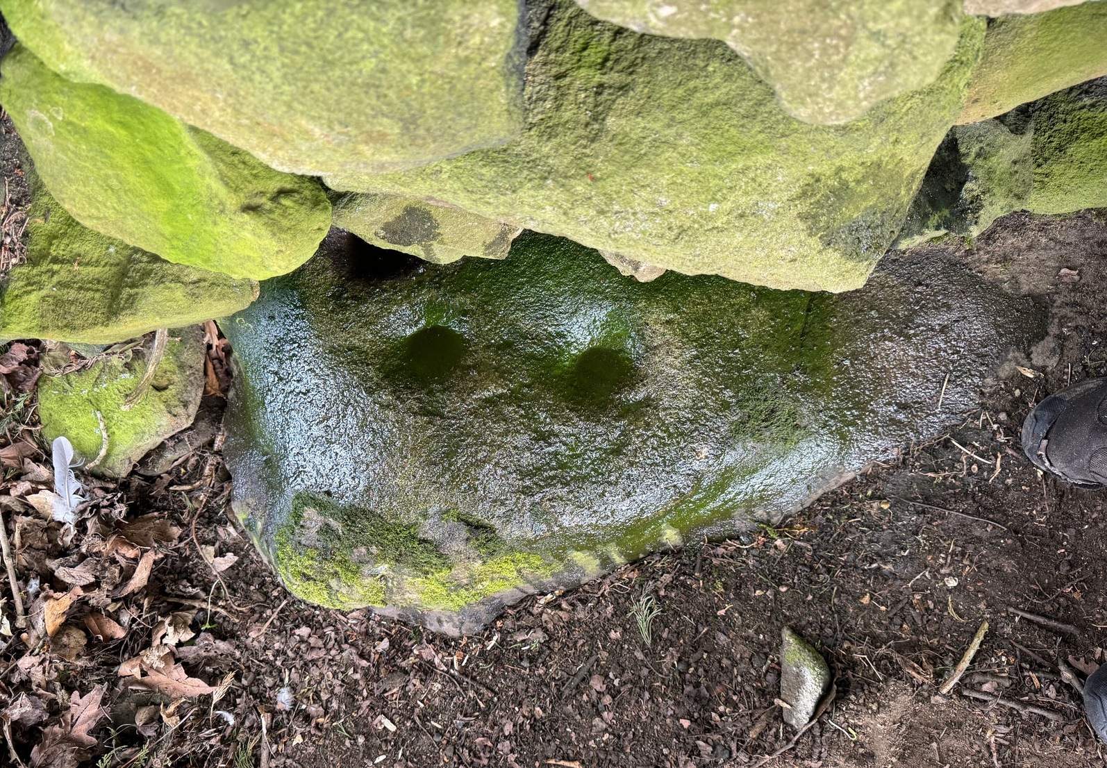
From Silsden, head up to Brunthwaite village and follow the same directions as if you’re going to see the Brunthwaite (1) cup-marked stone and, once there, look at the walling immediately behind it and you’ll see, at the base of the wall, peeking out is a small earthfast boulder. It’s about a yard away. You’ll find it.
Archaeology & History
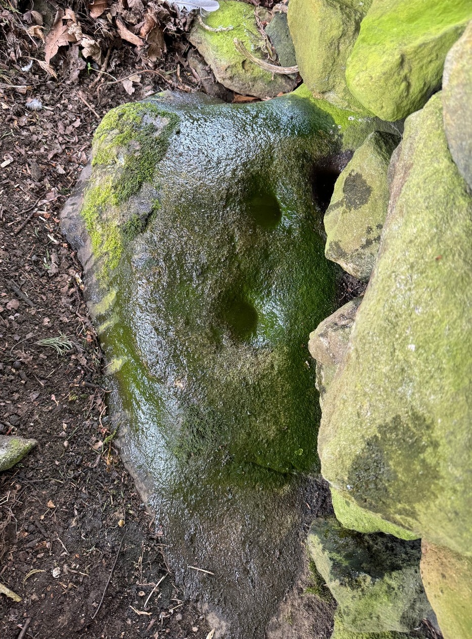
Sticking out from the edge of the walling at ground level is this low small cup-marked stone, rediscovered by rock art explorer Tom Cleland just a few weeks ago. It sits behind the cluster of rocks that were dumped here not too many years back. The carving comprises of at least three well-defined and quite deep cups, only two of which were initially visible until we cleared out a third one that had become filled with soil. It’s possible that there’s more of them on the stone, but we’d have to take the wall down to find that out!
The stone seems to be earthfast and may have remained in the same spot, untouched, since when it was first carved four or five thousand years ago—and certainly the depths of the cups suggest that its it’s been pretty much covered over for most of its life. The walling that’s been built on top of it is pretty recent by comparison; but it’s notable that its petroglyphic neighbour, the High Brunthwaite (3) carving, 175 yards to the east, is also an earthfast rock with the field-wall built on top of it.
Its somewhat minimalist appearance reminds me of several of the cup-marked petroglyphs at the top of Shipley Glen, six miles southeast of here, including the Baildon Moor (126) and (130) carvings…
Acknowledgements: Massive appreciation to Thomas Cleland for finding this carving and showing us it’s whereabouts.
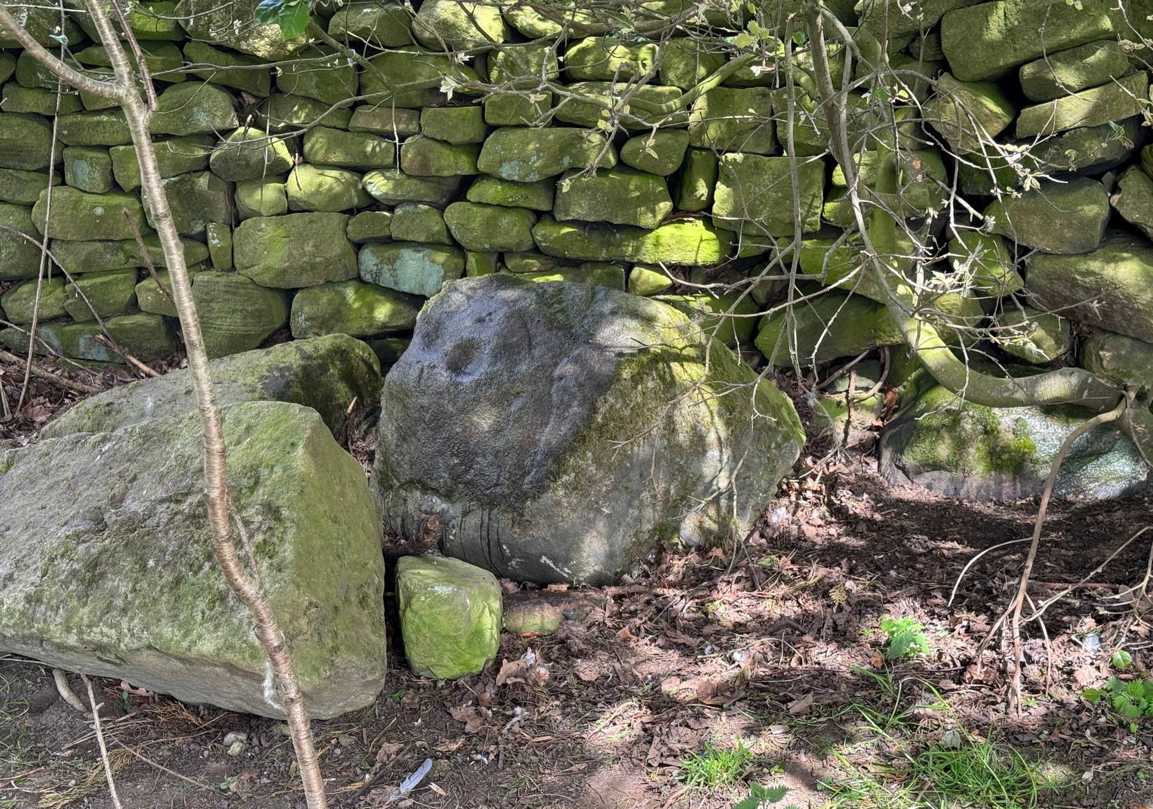
As you’re going into Silsden up the A6034 road, over the canal bridge, turn right (east) and go up Howden Road for half-a-mile, then go left up Hawber Lane and after 250 yards veer right along Brunthwaite Lane. After nearly another half-mile, through gorgeous High Brunthwaite hamlet and just as the road bends round past the last of the gardens and houses, go through the gate into the field on your right. You’re needing to look at the walling here, which runs alongside the road, but on the field-side, barely 10 yards up. A cluster of rocks has been piled-up against the wall. The largest rounded broken one is the one you’re looking for.
Archaeology & History
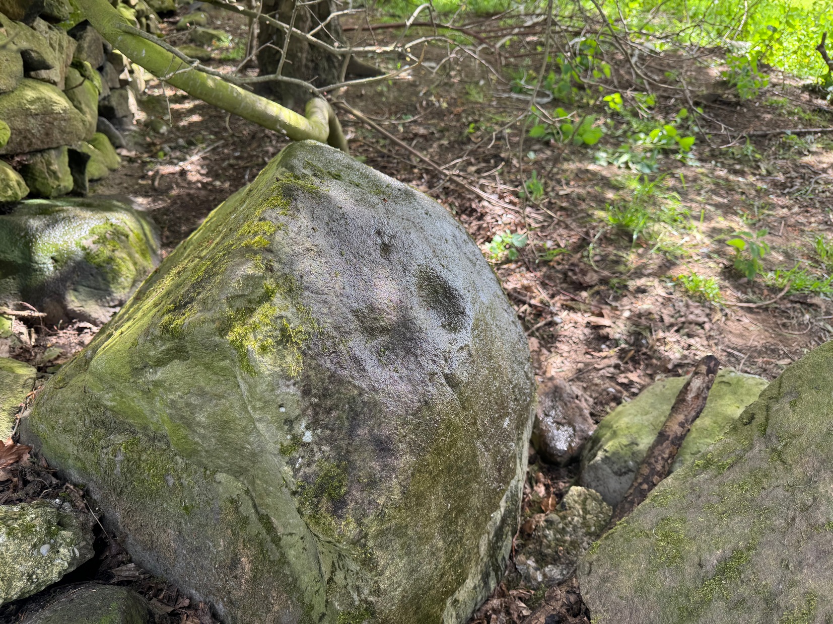
Looking across the cups
Discovered recently by the petroglyph explorer Thomas Cleland, this is one of two cup-marked stones in close attendance to each other. It’s nowt special to look at—unless you’re an ardent rock art buff!—as it consists of just two large well-formed cup-marks on its near-vertical face: the most distinct one being some two-inch across and a half-inch deep. The stone was obviously rolled here from very close by and just piled up against the wall and has been broken from a larger piece of rock, but we could see no other cup-marks on the others laid around it (although we couldn’t lift and turn the others over to see if there was anything on their undersides). The earthfast High Brunthwaite (2) cup-marked stone is just a yard away at the base of the wall.
Acknowledgements: Massive appreciation to Thomas Cleland for finding this carving and showing us it’s whereabouts.
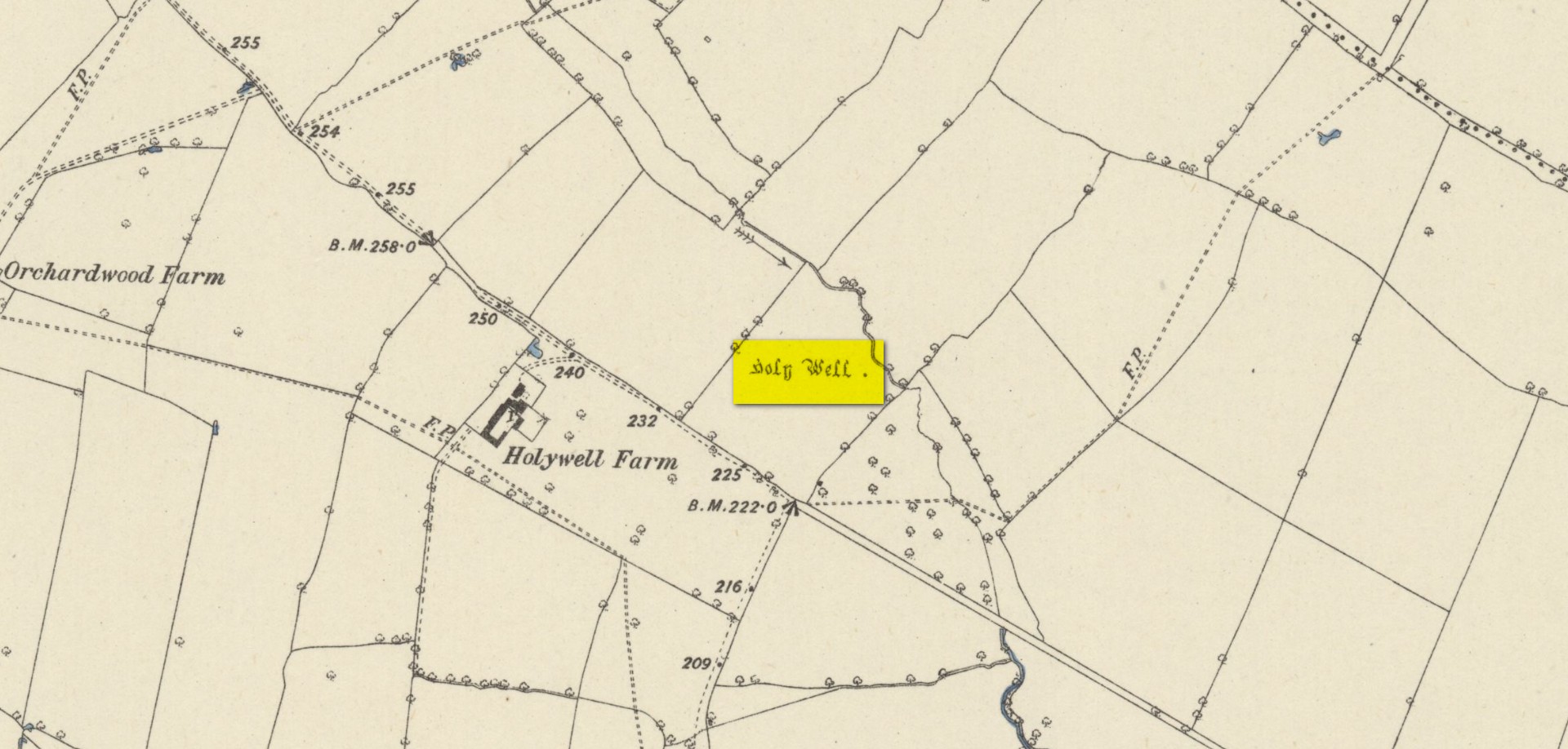
Found on the south-side of the stream a few hundred yards northeast of the aptly-named ‘Holywell Farm’ and highlighted on the early Ordnance Survey maps of the region, this once important sacred site is today, according to local folk, little more than an overgrown muddy patch, visited by very few and hard to see underfoot. It was described, albeit briefly in Leonard Jacks’ (1882) beautiful work, where he told that, “About a mile from the house is to be seen a holy well, a place of interest, which is undoubtedly connected with the past history of the place.”
In medieval times, the manor of Winkburn was the seat of the religious Order of the Knights Hospitallers, otherwise known as the Knights of St John of Jerusalem, to whom Bob Morrell (1988) professed this well to have been dedicated. He described there being a small structure around the water source, wondering whether it may have been a bath of sorts to convey water to the nearby house, but remains of this can no longer be seen. It would seem that a good ground survey of the site is required, at the end of Winter when all the vegetation has fallen back, to see if the waters can be recovered and the Holy Well brought back to life for local people. Fingers crossed! 🙂
Folklore
The water from St. John’s Well was said to be good for sore eyes. The religious celebration day of St. John is traditionally around June 24, usually overlaying earlier summer solstice celebrations.
References:
Jacks, Leonard, The Great Houses of Nottinghamshire and the County Families, W. & A.S. Bradshaw: Nottingham 1882.
Gover, J.E.B., Mawer, Allen & Stenton, F.M., The Place-Names of Nottinghamshire, Cambridge University Press 1940.
Morrell, Robert, Nottinghamshire Holy Wells and Springs, Nottingham 1988.
Acknowledgements:Huge thanks for use of the Ordnance Survey map in this site profile, reproduced with the kind permission of the National Library of Scotland.
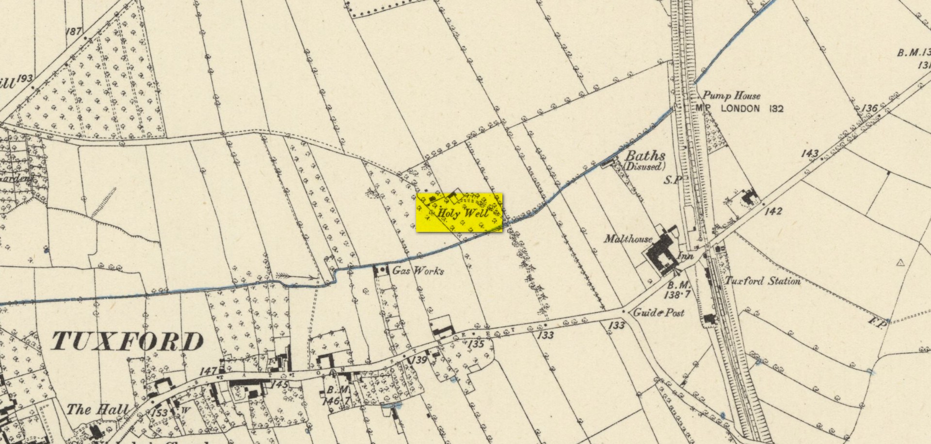
Highlighted on the early Ordnance Survey map of the region by the appropriately named ‘Holywell Farm’, this once important sacred water source would seem to be little more than a muddy patch nowadays. Not good. Its cold waters were reputedly good for curing skin diseases such as scurvy, along with aiding in the affliction of rheumatism.
Local folklore attributed the site to have once fed some Roman baths, but this idea seems to have been a diluted version of it once, historically, supplying some baths a few hundred yards east, albeit in the 19th century and not way way back in Caesar’s days! Of course, the waters of the well would have been used in ancient times, but we have no archaeology or unbroken traditions telling us such things. It was last known to be used as a local water supply in the 1920s. The fact that the spot where it used to run free is still sometimes boggy means that it could be re-animated with a bit of effort from local people.
References:
Morrell, Robert, Nottinghamshire Holy Wells and Springs, Nottingham 1988.
Acknowledgements:Huge thanks for use of the Ordnance Survey map in this site profile, reproduced with the kind permission of the National Library of Scotland.
From the Cow & Calf car-park, walk towards and past the gigantic Calf rock, swerving round the fallen mass of rocks and into the trees at the back. Walk uphill to the Hanging Stones cup and ring stones, then keep heading—down the slope then back up the next one—west, for barely 100 yards until you’re on the level ground again, following the footpath alongside the heather. Barely 50 yards along, keep your eyes peeled in the heather for a low flat rock just a few yards in. Forage around and you’ll find it.
Archaeology & History
You’ll no doubt be seeing this carving after you’ve visited the impressive Hanging Stones petroglyphs 150 yards to the east. And you’ll probably be disappointed in its lack of visual grandeur when compared to its more ornate eastern neighbour. But the petroglyph fans among you should give it your attention.
Hedges 1986 sketch
Looking to the SE
When the dawn or evening daylight cuts across the rock, the design looks much better than at sun high, perhaps telling us that the message of the stone coincided with those periods of the day. The gentle folds of the stone itself morph into the carving: evening and morning light cutting subtle shadowy folds across the rock, giving it an organic texture that our aboriginal ancestors told to be a vital essence of stone itself. The two small clusters of cup-marks upon this stone become greater than their basic design when brushed with the shadows and glows of a sunset. And when our aboriginal peoples painted them in ochre and other colours, an even greater mythos emerged—but sadly it is forgotten here….
When looked at with the simplistic eyes of the archaeo-mind, this and its compatriots are little more than a number of marks on lifeless rocks. This stone for example was described in John Hedges’ (1986) survey as being just “two groups of four and five cups and grooves”—nothing more—with naught but an echo in Boughey & Vickerman’s (2003) later work. The carving has neighbours even more basic in the heather close by…
References:
Boughey, Keith & Vickerman, E.A., Prehistoric Rock Art of the West Riding, WYAS: Wakefield 2003.
Hedges, John (ed.), The Carved Rocks on Rombalds Moor, WYMCC: Wakefield 1986.