From Pitlochry town centre, walk down the A924 high street as if you’re going to the Blair Atholl Distillery, but just before it take the right-turn and go over the river, and just keeping walking along this road for a third-of-a-mile (0.5km) until your reach a small small on your left that swerves up the hill (there’s a little signpost here saying Cluny Path to Strathtay). Go up and across the main road, then just keeping walking up the dirt-track, which becomes a footpath, and heads further uphill into and through the woodland. Make a bittova daydream from the walk up here, making sure to keep to the path closest to the burn (stream) on your left. Eventually when it levels out, you’re very close. Just keep on the same track and, where it meets up with another, bear left and about 100 yards along, on a small rise in the trees on your right, you’ll see these old stones peeking out. Keep your wits about you!
Archaeology & History
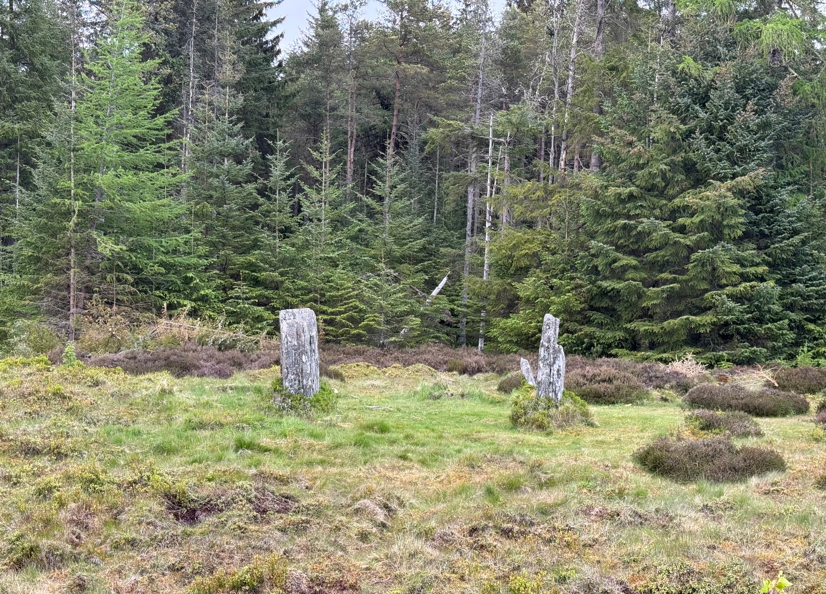
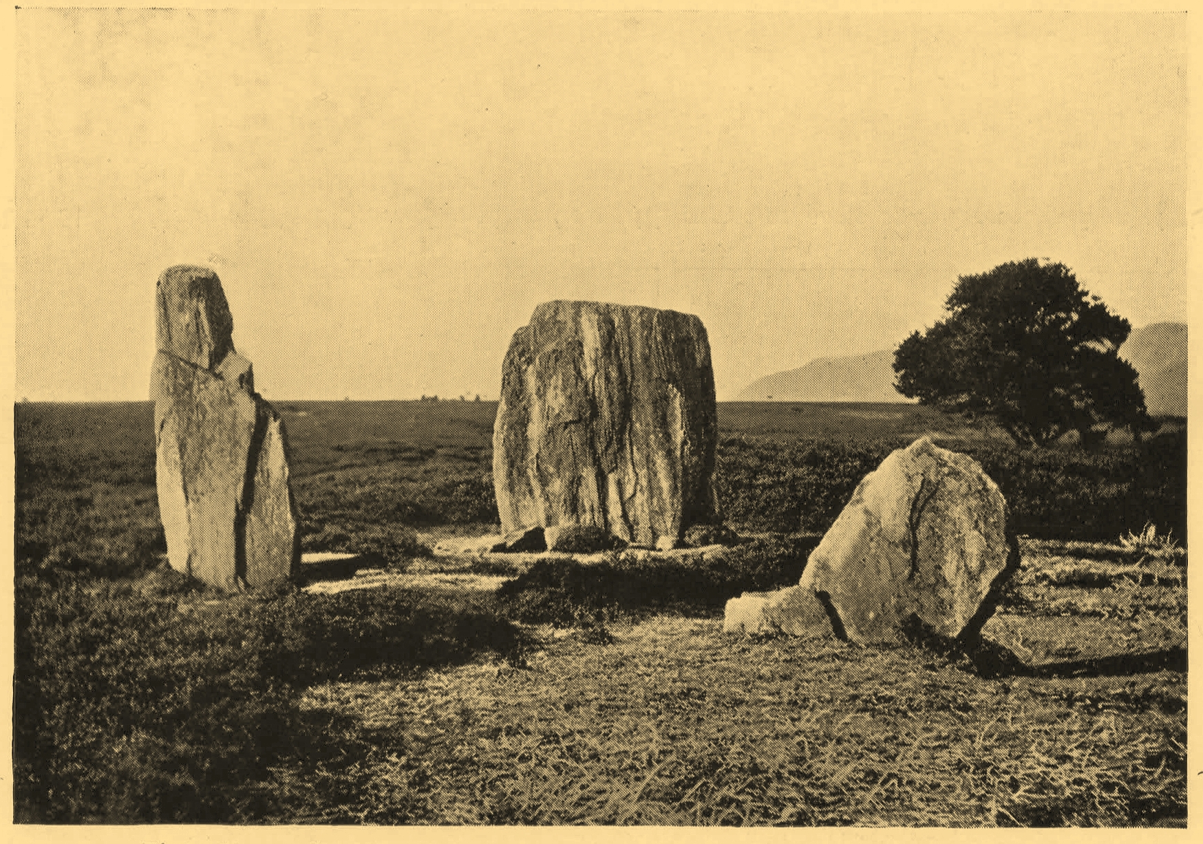
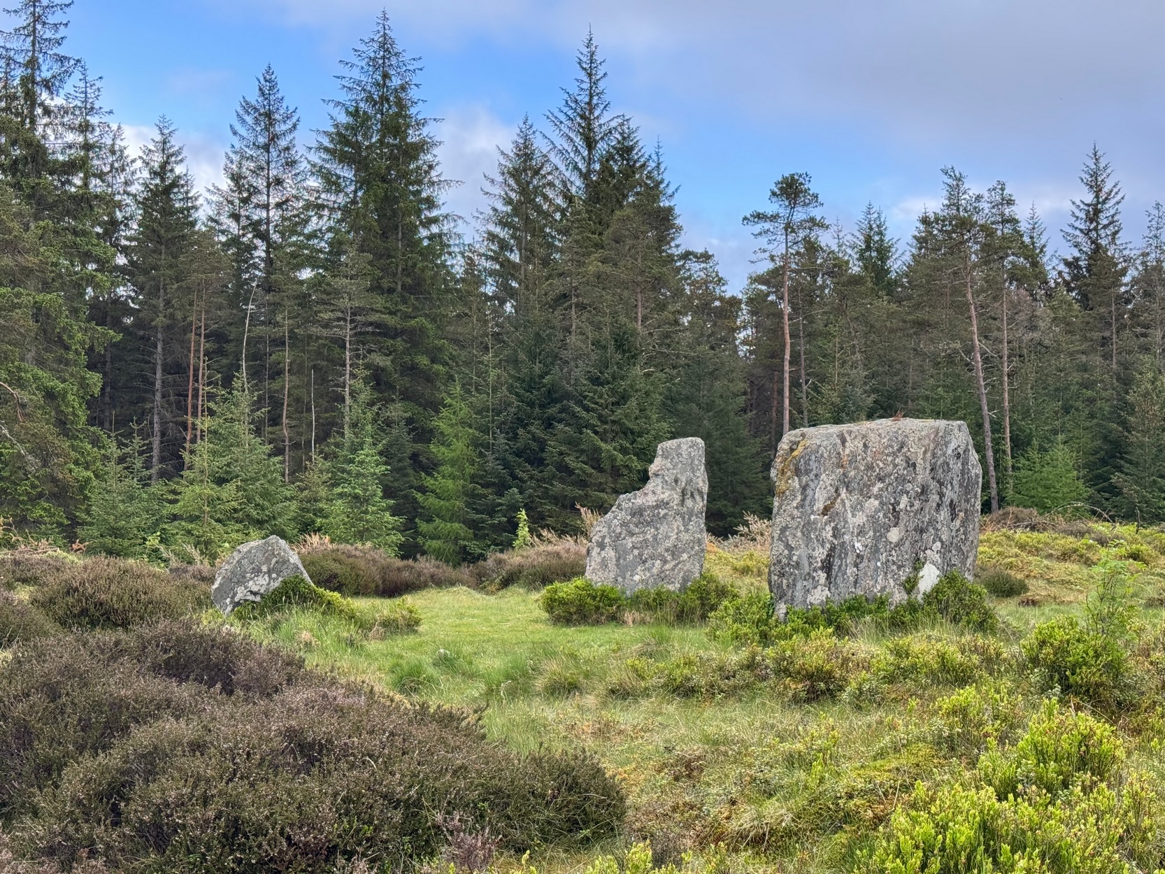
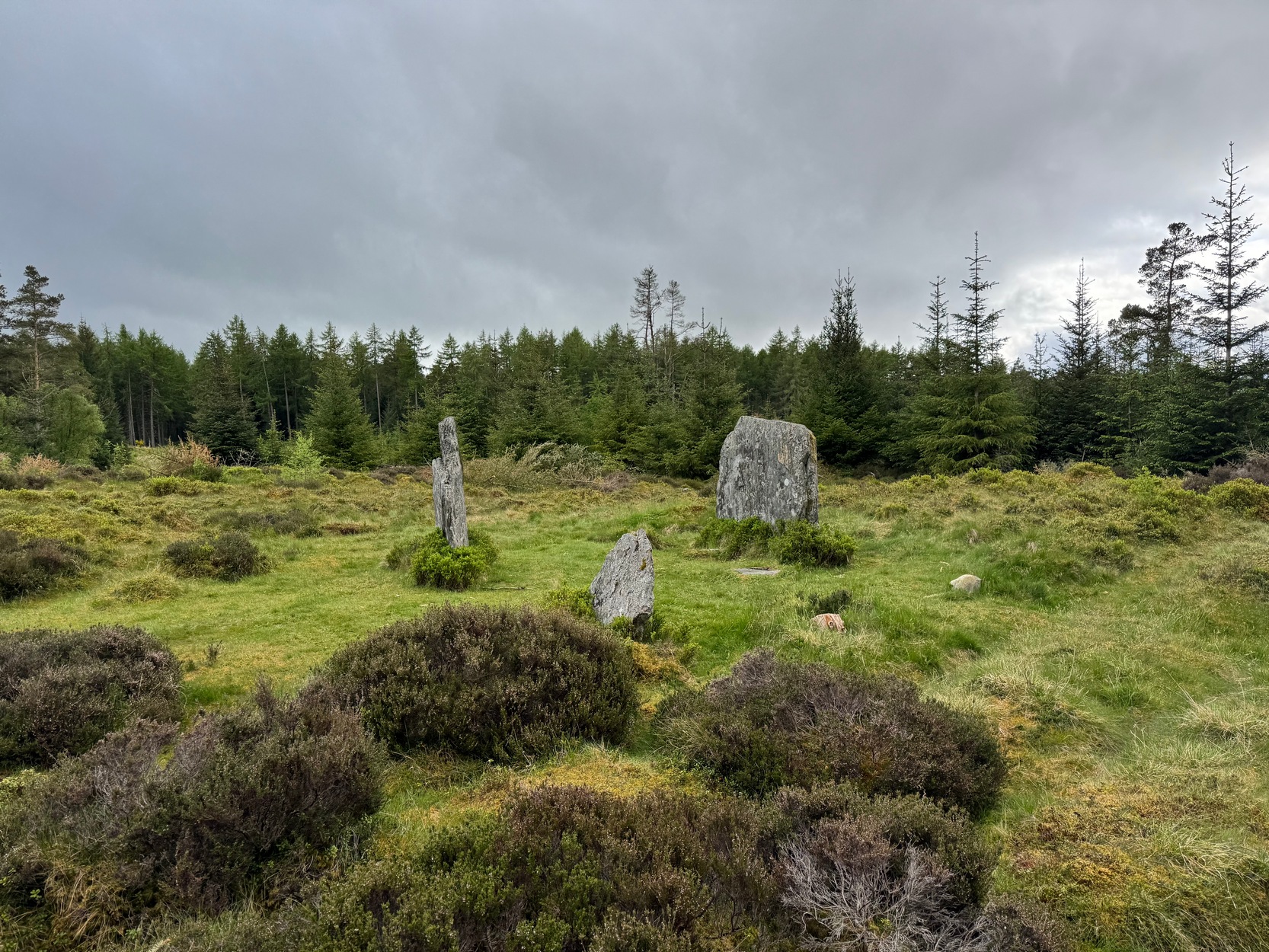
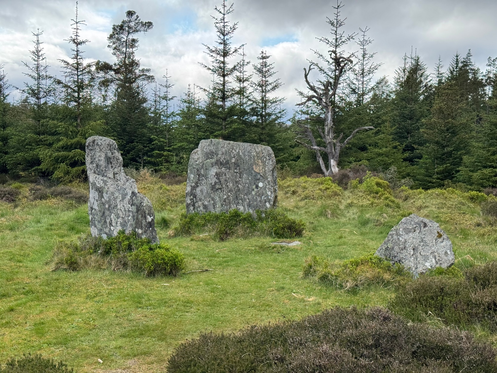
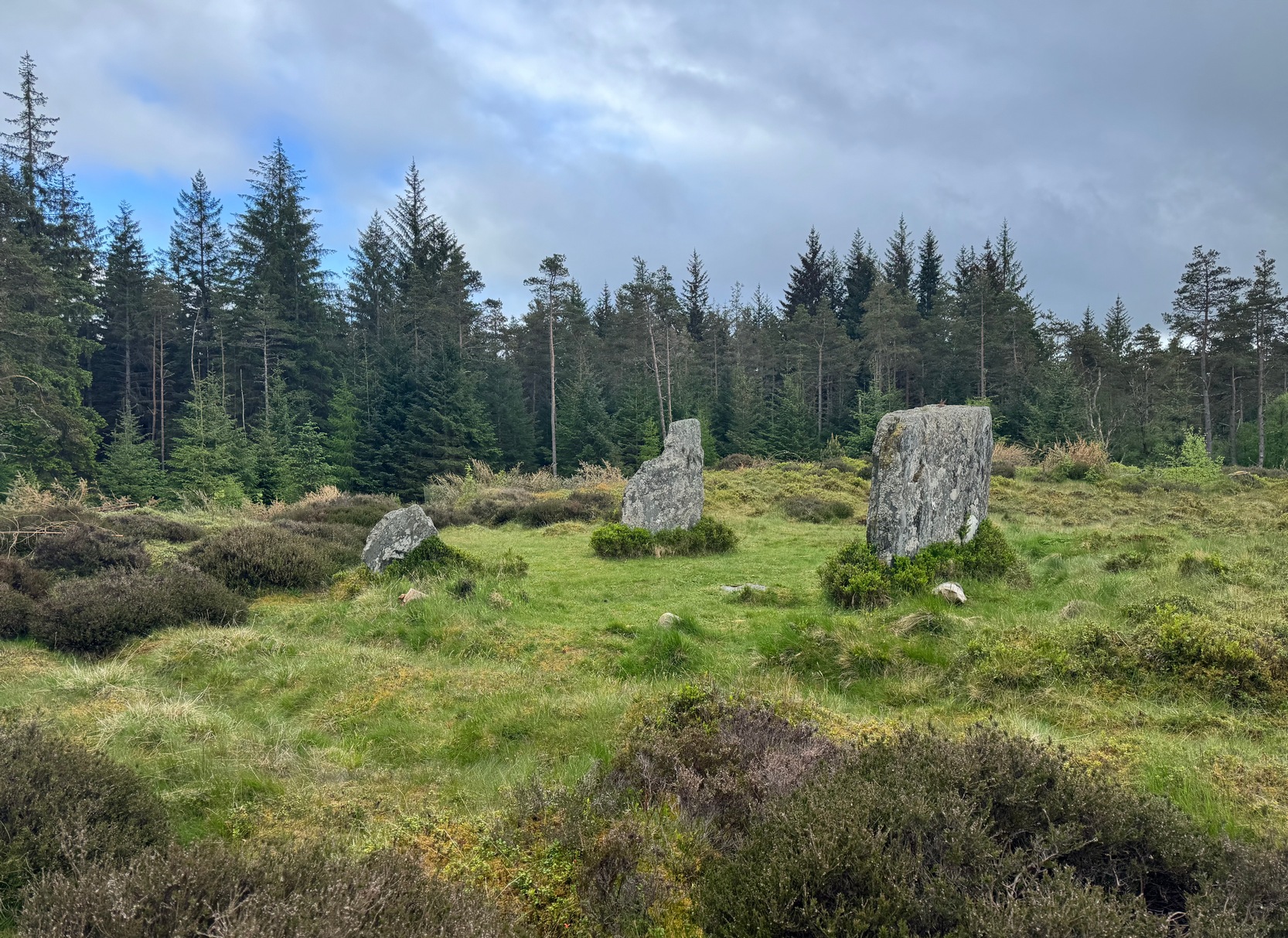
Clachan an Diridh looking E
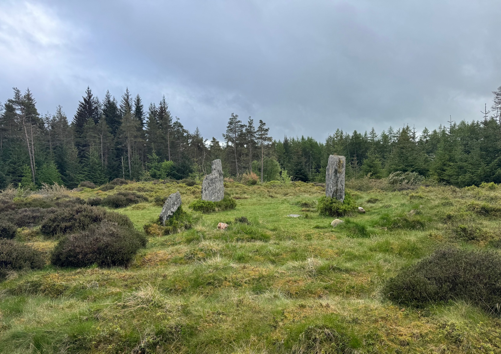
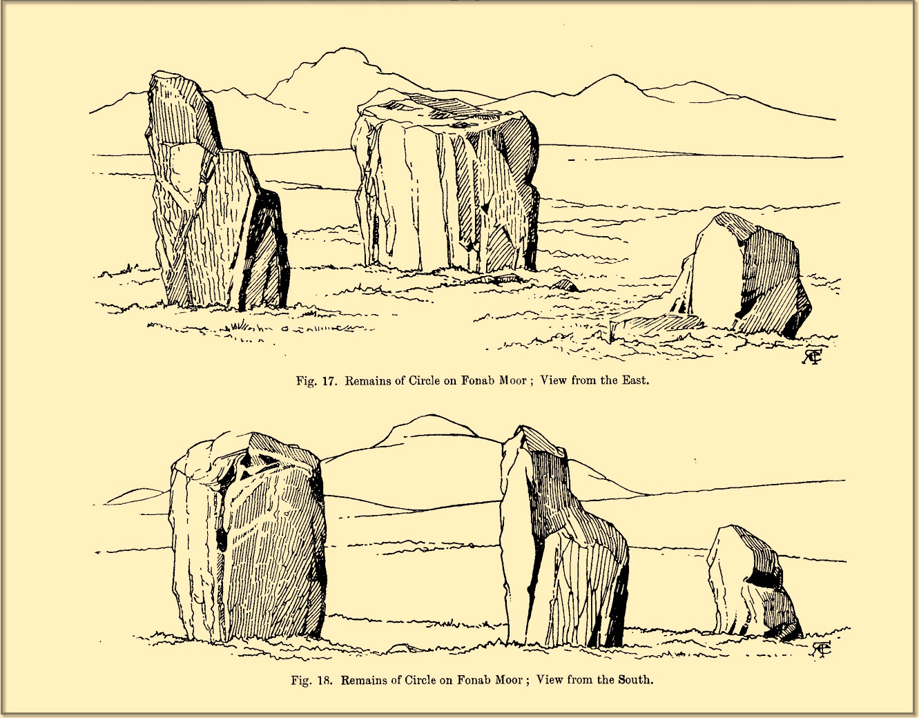
Sat high up on open moorlands with views all round… is what this site used to look like. Sadly, the forestry commission have almost completely enclosed this prehistoric site, making any view of the surrounding landscape all but impossible. I’m not the first and won’t be the last person to be pissed-off by such thoughtlessness. Alexander Thom made mention of it too. After making an initial assessment of the astronomical alignments at these stones in 1967, “when we returned to measure the horizon we found that trees had been planted round the stones and so we failed.” (Thom 1990) Not good.
On my first visit here, as I entered this “stone circle” my first impression was that it wasn’t a circle at all, but the remnants of a megalithic stone row! Thom thought the same. It’s the slender thin stature of the stones that do it to you: they almost cut the air and point the enquiring nose dead straight along the same angle that all the stones have been deliberately aligned to. I assume they’ve had a similar effect on other people over the years.
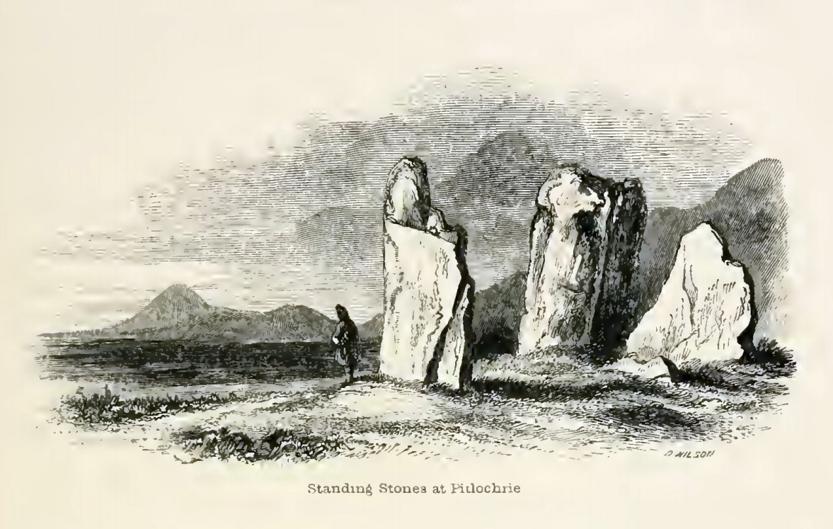
The Clachan an Diridh, or the Stones on the Ascent, were first mentioned in Dan Wilson’s (1851) major survey and who was so impressed by the view from here and its setting in the landscape that he compared its visage to Stonehenge. Were it not for the short-sightedness of the Forestry Commission destroying the view, most would no doubt agree with Wilson’s sentiments. From these olde stones, he told:
“One of the great level Highland moors stretches away beneath the eye, like a dark waveless lake, contrasting with the distant heights, among which Ben Lawers rears its pyramidal summit to an elevation of upwards of 4000 feet above the level of the sea. Amid this wild Highland landscape the huge standing stones, grey with the moss of ages, produce a singularly grand and imposing effect; and from the idea of lofty height which the distant mountains suggest, they convey a stronger impression of gigantic proportions than is produced even by the first sight of the giant monoliths of Salisbury Plain.”
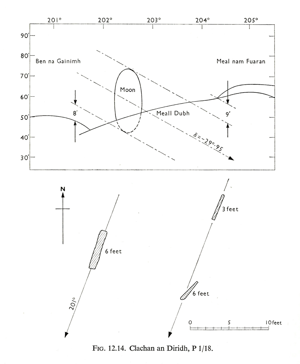
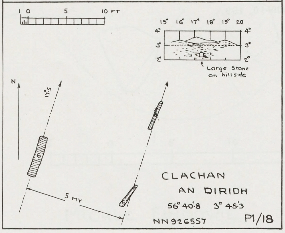
Thom’s initial moonset alignmentThom’s 1980 ground-plan with marker stone
The giant figure of Ben Lawers, if we could see it today, would rise to the southwest 20 miles (32km) from here; and the great pyramidal fairy mountain of Schiehallion would be equinox west, 13 miles (21km) away. Yet curiously when Alexander Thom surveyed the outlying hills, he didn’t think either of these mountains had any worth, astronomically speaking that is. Yet Lawers in particular would be the largest point on the southwestern horizon, rising in the distance, way beyond the wide rolling U-shaped glen of Strathtay to where the landscape changes into more rugged dynamic uplands. And the importance of Lawers as a place in prehistory is shown by the mass of petroglyphs across its slopes—particularly the side you could see from Clachan an Diridh.
Instead, Thom (1967) looked much further to the southwest—south-southwest in fact—where he initially thought that there was an alignment to the major southern moonset ten miles away above the rugged hill of Meall Dubh, framed on either side by the mountain peaks of Meall nam Fuaran and Beinn na Gainimh. Aubrey Burl (1988) told how Thom later discounted this alignment and instead turned his attention a full 180° where a large stone on the hillside to the north-northeast caught his theodolytic eye. This marked an alignment towards the peak of Ben Vrackie:
“There is little doubt,” he wrote, “that this is a lunar site showing perhaps…at the major standstill. Could one side of the southern 6ft high stone possibly have indicated the setting point of the Moon at minor standstill?” (Thom 1990)
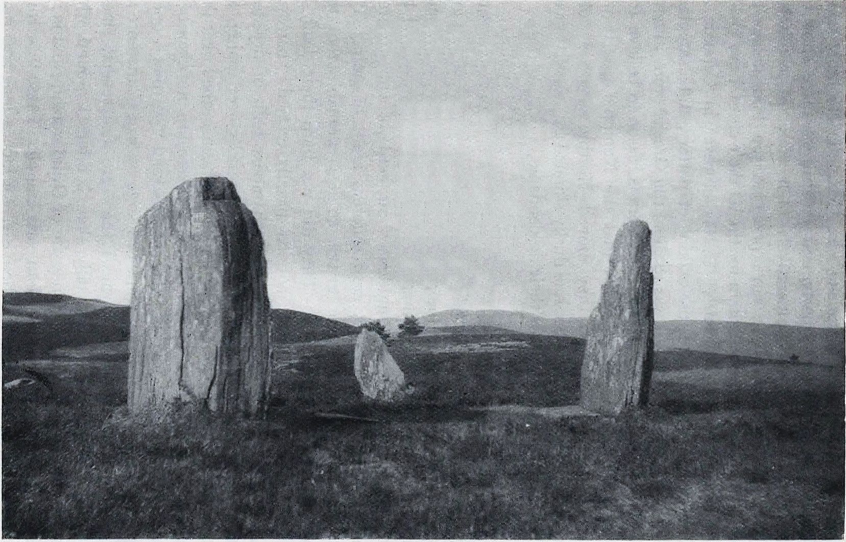
Clachan an Diridh in 1851Clachan an Diridh, c.1920
Thom looked at these stones and the landscape with the mind of an astronomer, whereas I’m more in preference of the aborigine who sees the feel of the landscape to discern relationships and meanings. Sometimes, of course, the sky and the landscape come together and that universal mythic union of heaven and Earth finds importance at a site. I have little doubt that such a mythos was once known here, on the moorland plateau, under the clear stars with the darkness reaching to speak with Lawers and other bones of landscape in the solid darkness of mountain silhouettes and fading horizons. Many a sleep at this site would have touched minds with Wonder…
Anyway, all that aside…
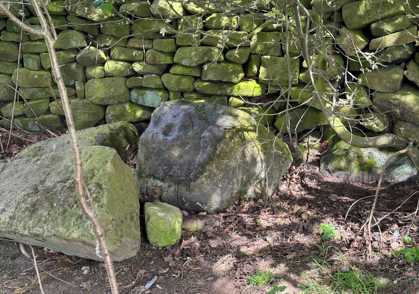
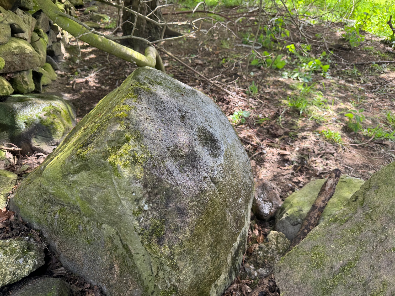
Large fallen stoneSite on the 1899 OS-map
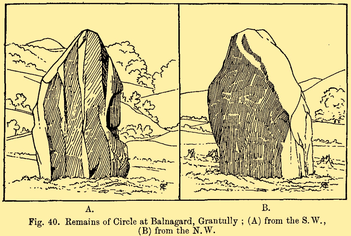
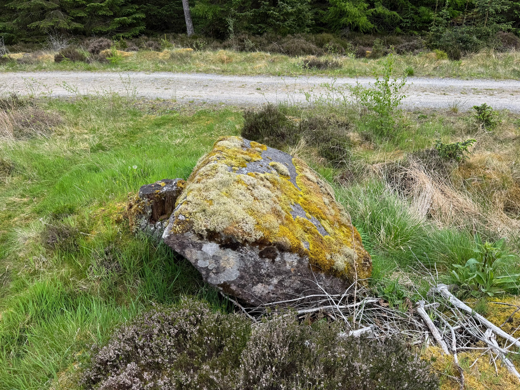
These megaliths have been classified as one of Aubrey Burl’s “four posters”, i.e., a rough square of four megalithic uprights, in spite of there only being three standing stones here. Even when Dan Wilson (1851) wrote about the place there were just three of them. However, down the slope from the stones, just off the recent trackside, there’s a decent contender for the fourth stone lying on its side in the undergrowth, half-covered in moss. It’s certainly fallen or rolled down the slope and its size and shape suggest that it may once have stood upright. Have a thoughtful fondle of it while you’re here.
The ‘circle’ was highlighted on the 1899 OS-map and, a few years later, was visited and surveyed by the great Fred Coles (1908) and like Dan Wilson before him, told the view from here to be “very grand.” He continued:
Coles 1906 planColes’ views, from S & E
“In local parlance this group is known as the Four Stones. This must be a fairly old name handed down through some generations; because, for at least fifty-seven years past, only three Standing Stones have remained in situ. These three Stones are arranged as shown in the plan…in a group forming in its now imperfect condition a triangle which, measured from the centres of the Stones, has its SE side 11 feet 6 inches long; its SW side 12 feet 3 inches ; and its north side 16 feet 3 inches. Fragments of the demolished fourth Stone lie about the ground; but there is no clear indication of its original position. The South Stone, A, is 3 feet 7 inches in breadth, 5 feet 10 inches in height, and from 12 to 4 inches in thickness. The West Stone, B, 6 feet in height, measures 5 feet at the back, and 4 feet 10 inches at the front, and is 18 inches in thickness. The East Stone, C, at its outer angle is 3 feet 3 inches above ground, and leans inward. All the blocks are of quartziferous gritty sandstone, the East Stone being particularly rough and fissured. A large fragment lying near it seems to be a portion of it. The Stones are set upon a fairly true Circle with a diameter of 15 feet 4 inches. One feature quickly arrests notice: this is, that the broader faces of these Stones are not set even approximately upon and in line with the circumference, but nearly parallel with each other—an arrangement quite unlike the setting of Stones in the many other Circles hitherto surveyed.”
When Burl (1988) added this site to his Four Posters survey he merely echoed Coles’ early description, adding that, in his view, the standing stones that we see today were probably, originally, “set out on the circumference of a circle 20ft (6.1m) in diameter.”
I think it’s likely that there would have been more prehistoric sites in the vicinity, but a notable oddity is the almost complete absence of other recorded sites anywhere nearby. Of course, if there was anything, those thoughtful Forestry Commission heads would have destroyed it. We are left, simply, with the old but reliable notes of Messrs Dixon (1923) and Mitchell (1925) who told that, in their days, other remains did exist nearby in the form of ancient cairns and hut circles—‘Pictish’ according to tradition. If we’re lucky, some damaged parts of them might still be found at the edges, a short distance to the north west…
Folklore
In Hugh MacMillan’s (1901) gorgeous literary sojourn along Strathtay, he strayed somewhat from his otherwise historical notices by telling that here,
“on the highest part of the moorland…is a group of ‘clachan iobairt’, or stones of worship, where the Druids of old performed their mysterious rites, going round the circle of standing stones from east to west with the sun, or the ‘car deasal’, the lucky side, when they wished to invoke a blessing upon their friends, and going round the circle in the opposite direction, from west to east, the ‘car tuathsel’, or unlucky side, when they wished to pronounce a curse upon their foes.”
Whether this was what Hugh Mitchell (1923) meant when he referred to the traditions surrounding Clachan an Dirirdh we don’t know, but he echoed MacMillan’s account (though made no reference of his words), also adding that it was a site that “was visited on the first of May” or Beltane by some local people….
References:
Burl, Aubrey, Four Posters: Bronze Age Stone Circles of Western Europe, BAR 195: Oxford 1988.
Burl, Aubrey, A Guide to the Stone Circles of Britain, Ireland and Brittany, New Haven & London 1995.
Burl, Aubrey, The Stone Circles of Britain, Ireland and Brittany, Yale University Press 2000.
Dixon, John H., Pitlochry, Past and Present, L. Mackay: Pitlochry 1925.
Kennedy, James, Folklore and Reminiscences of Strathtay and Grandtully, Munro Press: Perth 1927.
Liddell, Colin, Pitlochry – Heritage of a Highland District, PKDL: Perth 1993.
MacMillan, Hugh, The Highland Tay: From its Source to Dunkeld, H. Virtue: London 1901.
Mitchell, Hugh, Pitlochry District: Its Topography, Archaeology and History, L. Mackay: Pitlochry 1923.
Omand, Donald (ed.), The Perthshire Book, Birlinn: Edinburgh 1999.
Stevenson, J., “Prehistory,” in Omand’s The Perthshire Book, Edinburgh 1999.
Thom, Alexander, Megalithic Sites in Britain, Oxford University Press 1967.
Thom, Alexander, Megalithic Lunar Observatories, Oxford University Press 1971.
Thom, A., Thom, A.S. & Burl, H.A.W., Megalithic Rings, BAR: Oxford 1980.
Thom, A., Thom, A.S. & Burl, Aubrey, Stone Rows and Standing Stones – volume 2, BAR: Oxford 1990.
Wilson, Daniel, The Archaeology and Prehistoric Annals of Scotland, Sutherland & Knox: Edinburgh 1851.
Acknowledgements: Huge thanks for use of the Ordnance Survey map in this site profile, reproduced with the kind permission of the National Library of Scotland.
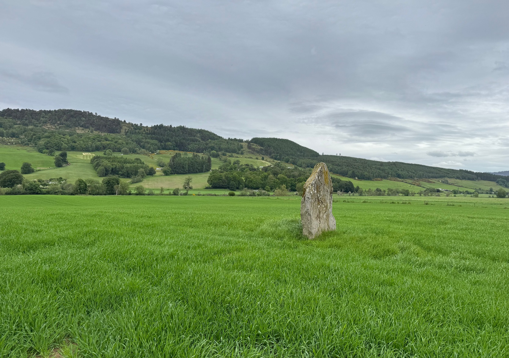
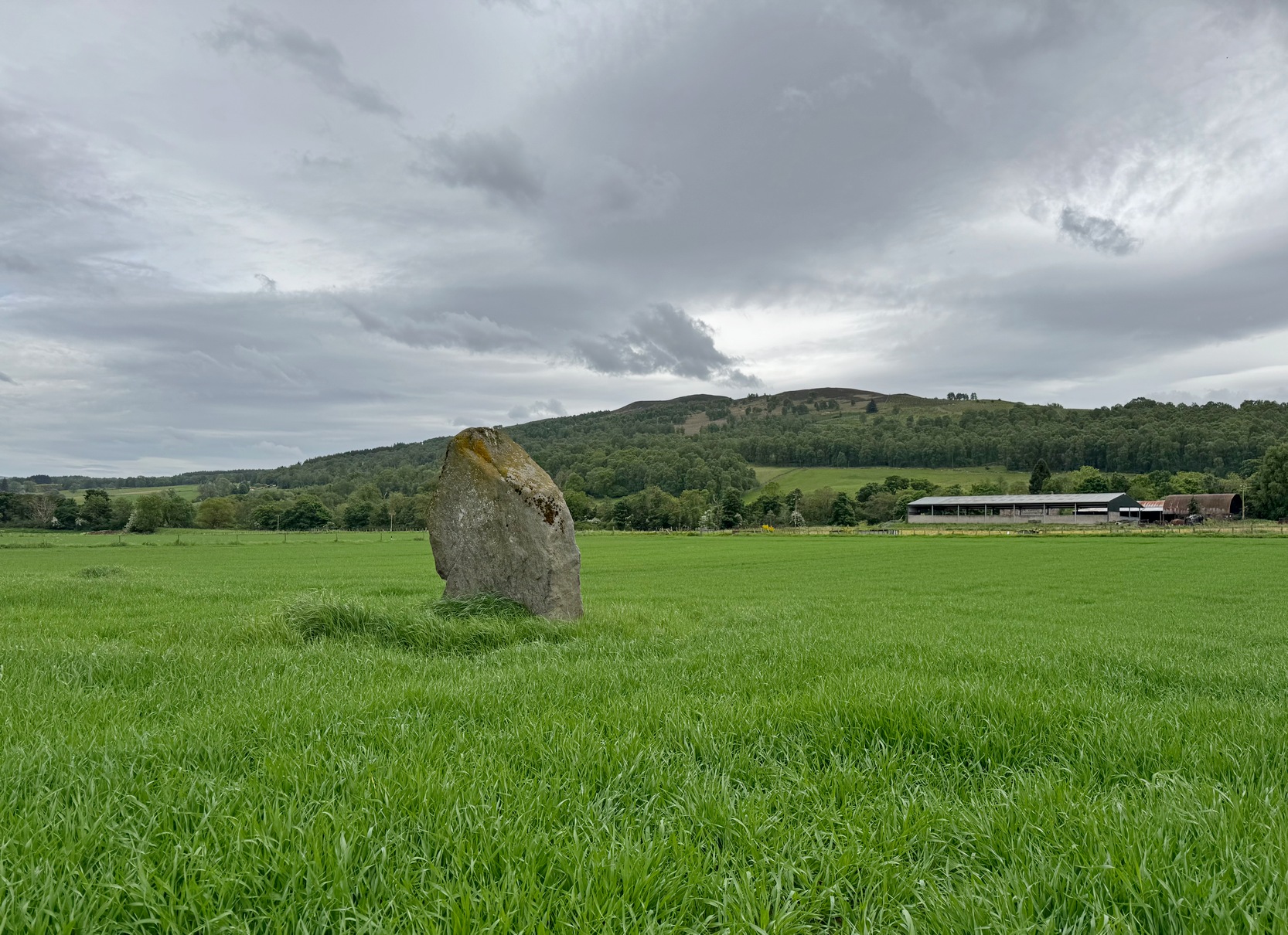
Just as you’re coming into Balnaguard village on the B898 road from the eastern side (as if you’ve come via the A9 from near Pitlochry), just where the road crosses a small burn (stream), take the first farm-track on your right and walk down to the end where it meets the field. Here, walk to your left left and you’ll see a gate that takes you into the field. You should have already noticed the standing stone before you even open the gate! It’s about 100 yards in front of you. You can’t really miss it.
Archaeology & History
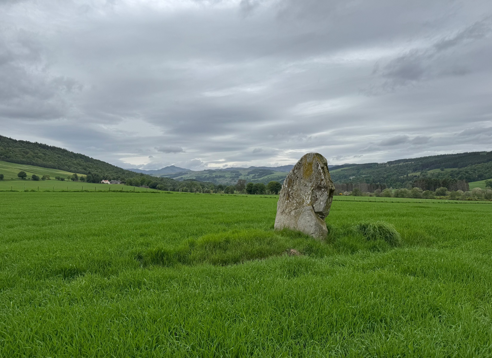
Clach na Croiche
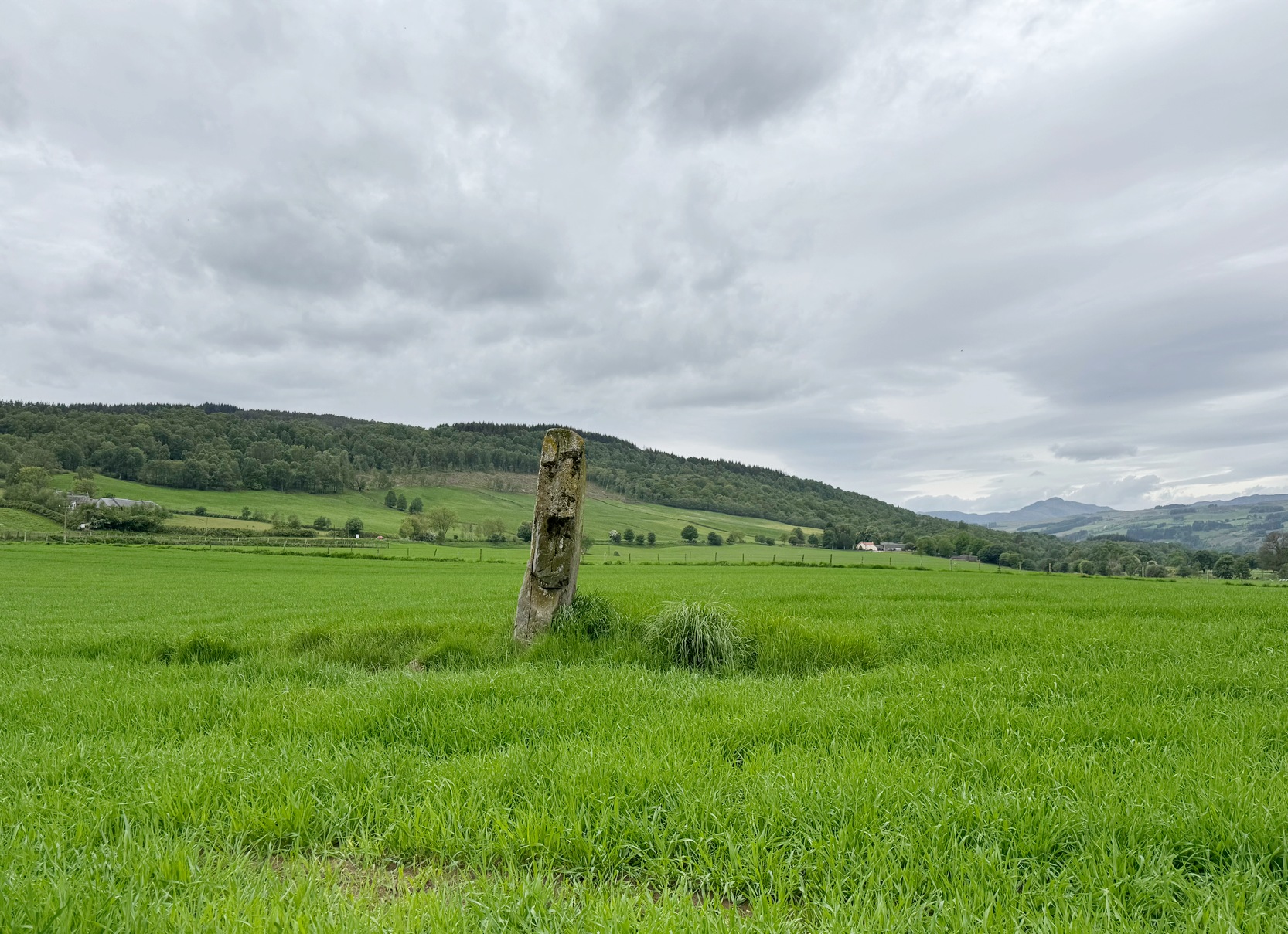
Standing alone in this field a short distance south of the River Tay is this fine old standing stone, nearly seven feet high, from whose locale we gaze west to the opening of the Perthshire mountains—but in times gone by it wasn’t alone. Less than 10 yards east of the Clach na Croiche stood another seven-foot tall standing stone and, some six yards further east (and along the same axis) there may have stood another one, some 7½ feet high. This alignment ran east-west in line with the rising and setting of the sun at the equinoxes. (whether that was deliberate or not is another matter altogether) and was first noticed by the great antiquarian Fred Coles (1904) in one of his many megalithic ventures. He wondered “whether they (were) fallen Standing Stones, or the covers of cists” and when they were looked at by Margaret Stewart in 1971 she found that one of them laid beside “a shallow socket outlined with packing stones”—meaning that it had stood upright. The other stone didn’t seem as certain, although Stewart did report finding “a single cupmark…on the eastern side of the upper surface.” We’ve yet to see a photo of this carving.
The Clach na Croiche also has its own cup-markings, just above the bottom of the stone on its southern-face. Margaret Stewart described them as being “strung out irregularly across the face.” Sounds about right! Sadly, somehow, I didn’t get any photos of these when I last visited, but will grab some the next time I’m there.
Looking to the westLooking to the northeast
In the fields either side of the stones, ancient tombs have been found. Around 1887, the Duke of Atholl dug under some of the stones in the field and found a “cup” or urn which Coles reported “was found in a cist in the haugh near Tom-na-Croiche.” Then, in 1969, the farmer John MacBeth was ploughing the field and unearthed another cist some 15 yards north-west of the present upright. The base of the cist was cobbled and whilst whilst the tomb itself was filled-in, the farmer moved the covering stone to the fence at the west-side of the field (NN 9455 5205). Also, on the eastern side of the field in 1971, Stewart reported finding what she thought were the remains of cremated bones that seemed to have been part of another prehistoric structure.
Fred Cole’s 1904 sketchLooking to the southeast
Nearly 250 yards to the west of the stone, in the adjacent field, a huge prehistoric cairn—known as the Sketewan Cairn—was uncovered and fully excavated in the late 1980s. It originally stood some four feet high and was nearly seventy feet across. Within the cairn complex, a small standing stone accompanied some cremations. Unfortunately this entire archaeological site has since been completely covered over. You wouldn’t even know it was there if you stood right next to it! But if you want to see Balnaguard’s remaining tombs, head for the Fairy Mound right in the heart of the village…
Dixon, John H., Pitlochry, Past and Present, L. Mackay: Pitlochry 1925.
Kennedy, James, Folklore and Reminiscences of Strathtay and Grandtully, Munro Press: Perth 1927.
Omand, Donald (ed.), The Perthshire Book, Birlinn: Edinburgh 1999.
Stevenson, J., “Prehistory,” in Omand’s The Perthshire Book, Edinburgh 1999.
Stewart, Margaret E.C., “Perthshire: Balnaguard”, in Discovery & Excavation in Scotland, 1971.
Swarbrick, Olaf, A Gazetteer of Prehistoric Standing Stones in Great Britain, BAR: Oxford 2012.
Yellowlees, Sonia, Cupmarked Stones in Strathtay, Scotland Magazine: Edinburgh 2004.
Acknowledgements: Huge thanks for use of the Ordnance Survey map in this site profile, reproduced with the kind permission of the National Library of Scotland.
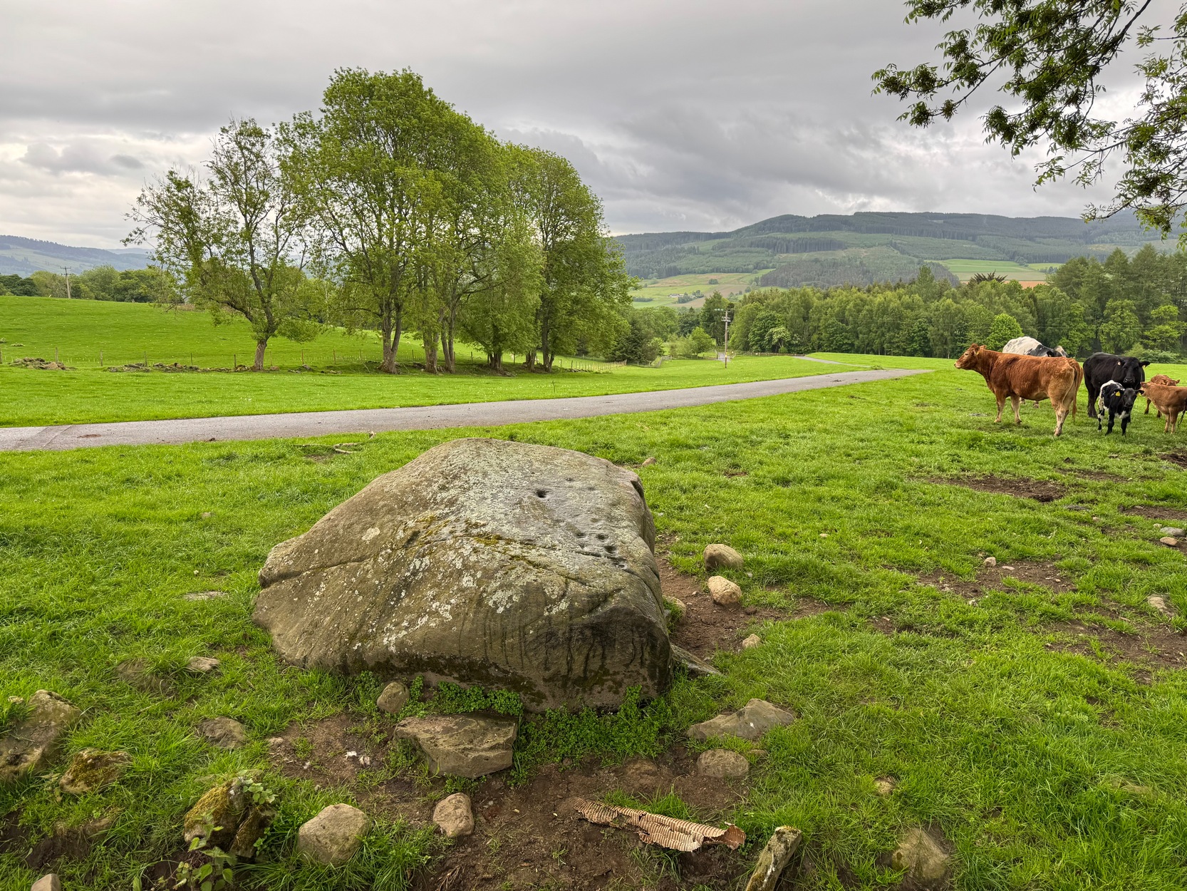
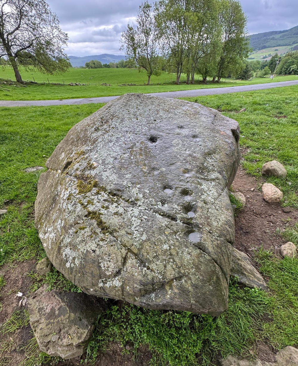
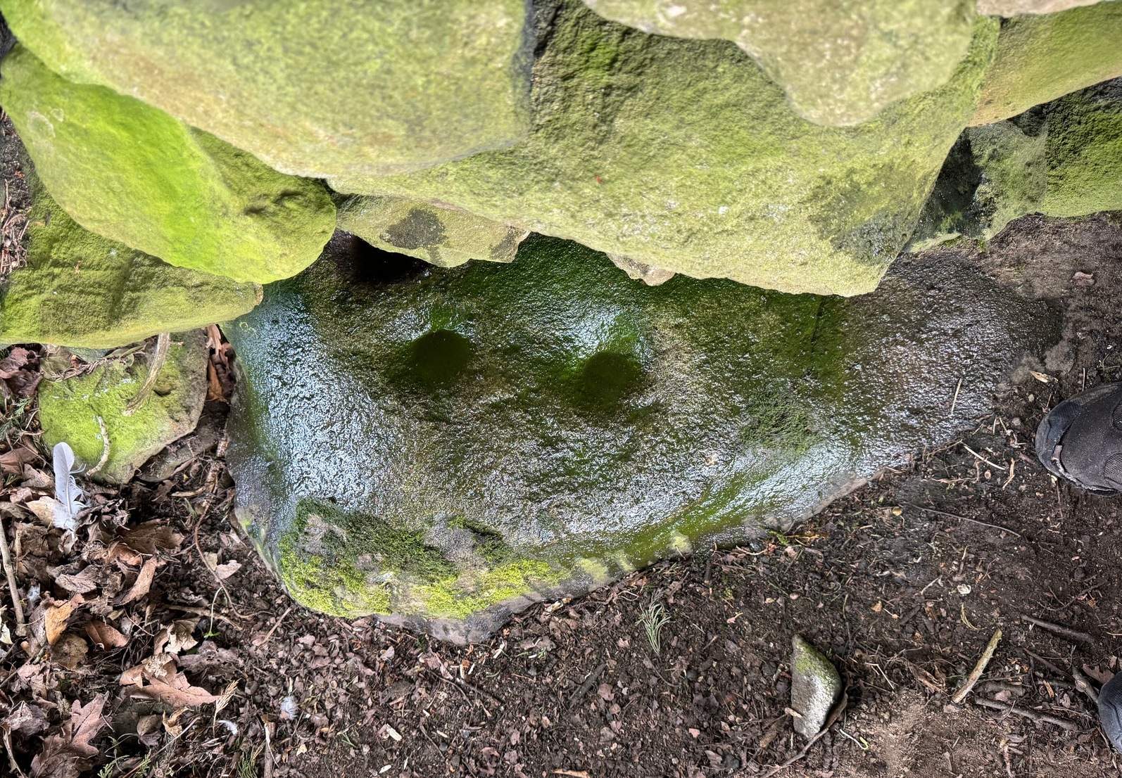
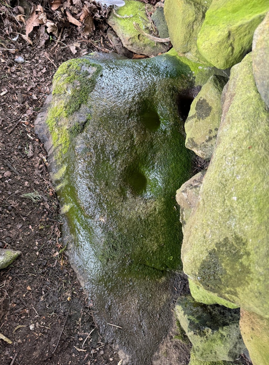
Various ways to get here, but it’s probably easiest if you’re coming via Aberfeldy. From here, go over the river bridge to Castle Menzies and Weem, but turn right once you’ve crossed the bridge and follow the road parallel to the river for just over 3 miles (4.9km) where you’ll reach a tiny road on your left, going uphill. You can park the car 150 yards up, on your right – then walk uphill (don’t drive any further). Walk up the road for just over half-a-mile (0.95km) and take the right turn; go along here for 300 yards where the pond appears and keep walking along the same road for another 250 yards till you reach a cottage by a small crossroads. From here, walk up (left) for another 300 yards where, near the top of the field, a large boulder sits close to the fence. You’ve arrived!.
Archaeology & History
Drumchanachan carving
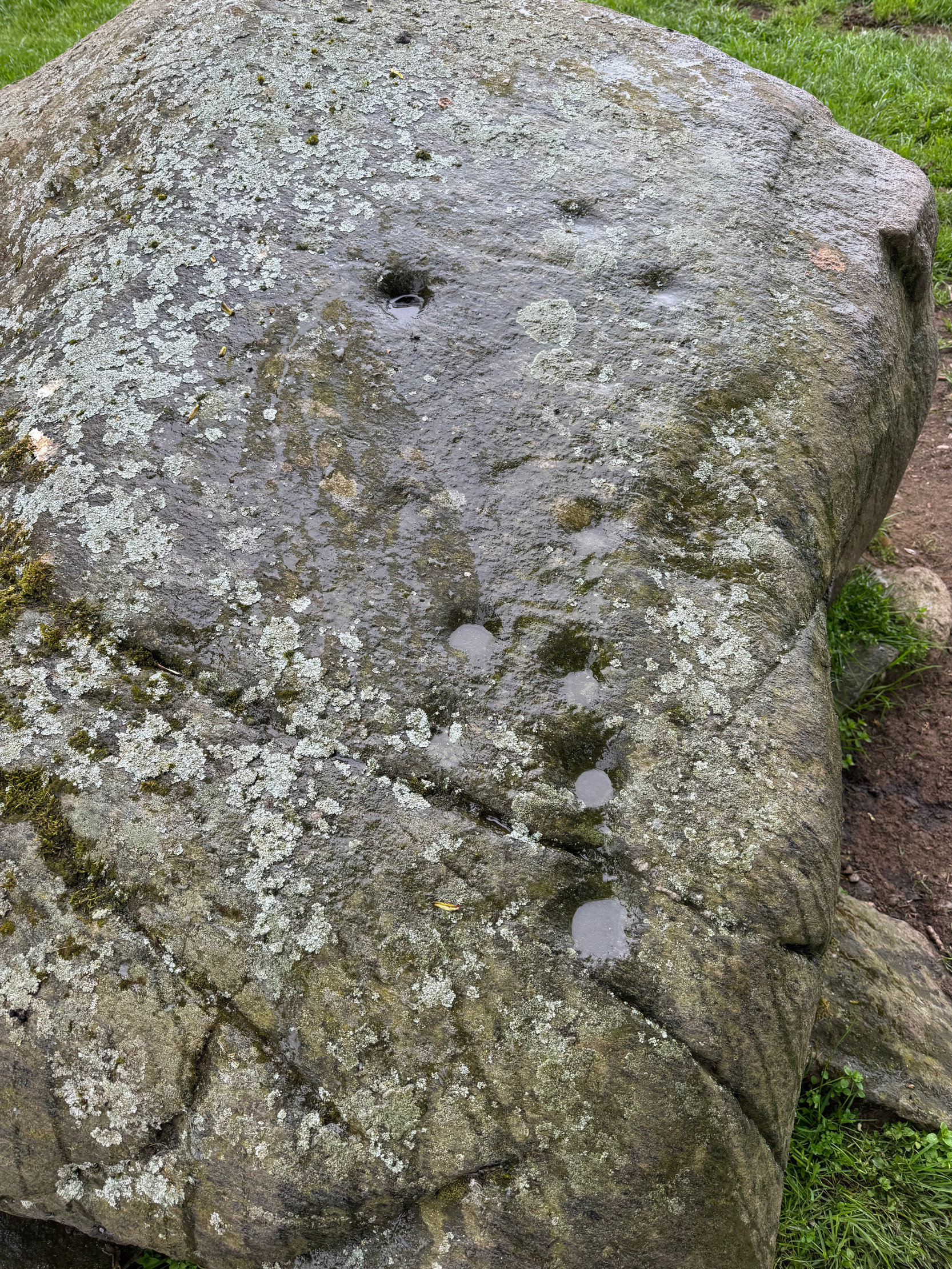
On the way back down from a bimble to the beautiful and haunted Loch Derculich, Naomi and I stumbled upon this large stone just off the track below Lurgan farmhouse and found there to be a number of cup-marks on its sloping upper surface. Naomi was really truly excited! 🙂
On its northwestern surface there’s is a distinct scattering of cup-marks: one in particular near the middle of the stone that’s been deepened in more recent times, as if it was ready to be blown-up and destroyed but, once realised it was a stone of the fairy folk, the operation was terminated and the stone left here to live! Thankfully…
Close-up of cupsDeep lines of cups
It’s a pretty basic design, consisting of at least eleven cup-marks, mainly running in a line upwards along its westernmost side, following the edge of a natural ridged contour. Of the two topmost cups, one of them may have a carved line running to it with a faint semi-circle then emerging from the line around the edge of the cup. But it’s faint—if it’s real—and the daylight was fading when we came here so this and any other design elements that may exist weren’t too easy to see. Hopefully I’ll get back up here pretty soon and see if there’s anything else hiding beneath the aged shadows.
It’s a wonderful arena above Edradynate, with countless other ancient sites peppered across the landscape hereby…
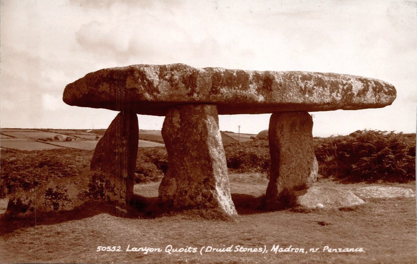
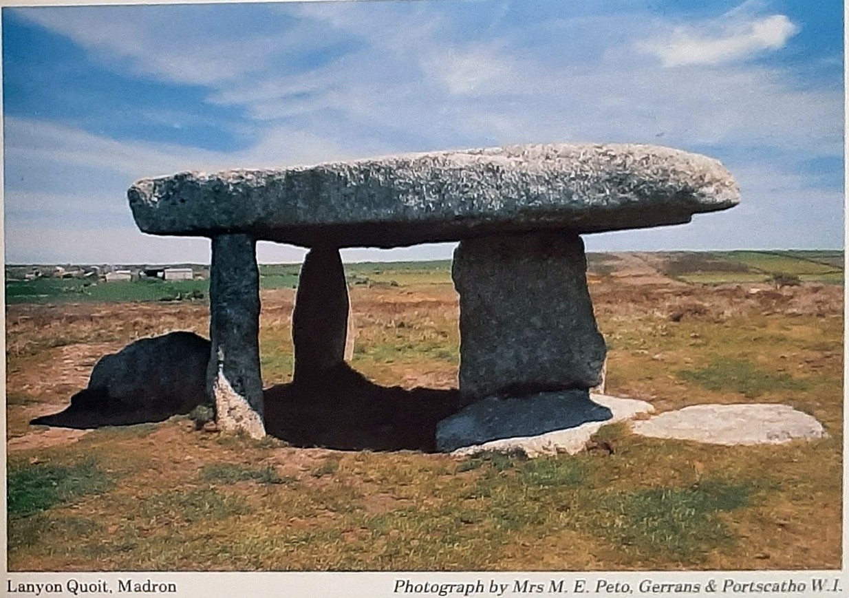
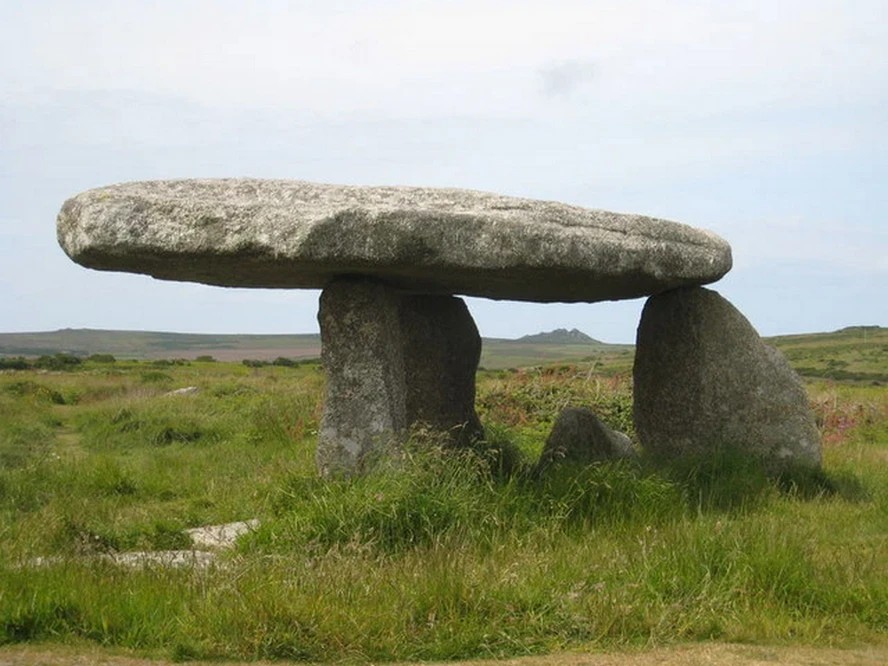
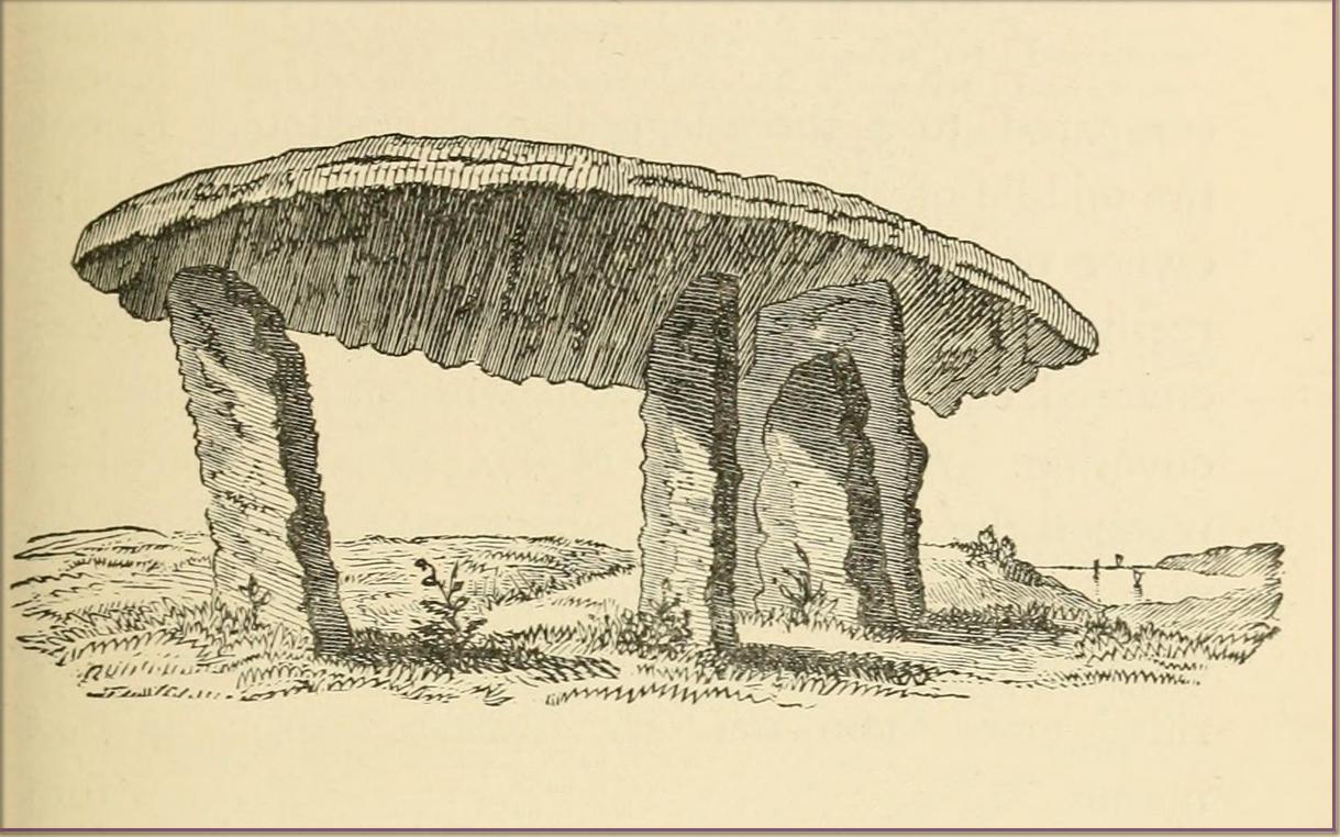
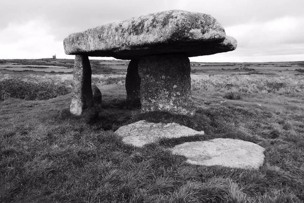
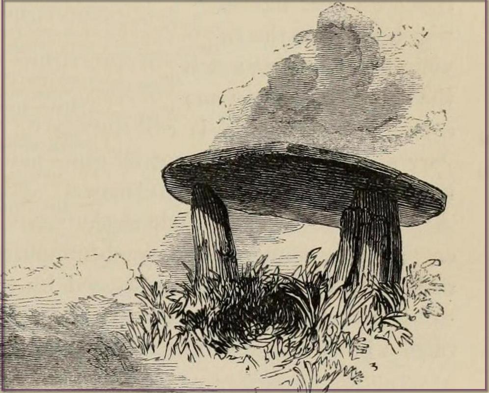
William Borlase (1769), in his revised classic on the megaliths & antiquities of Cornwall, wrote:
“Since we are now considering these Stone-monuments, there is a very singular Monument in the Parish of Madern (Cornwall) which in this place, will naturally offer itself to our enquiry. In the Tenement of Lanyon stand three Stones-erect on a triangular Plan. The shape, size, distance and bearing, will best be discerned from the plan and elevation of them…
“The length of the area described by the supporters of Lanyon Quoit is seven feet; but it does not ſtand East and West, as at Molfra, but North and South… There is no Kist-vaen, that is, no area marked out by Side Stones, under this Quoit, which is more than 47 feet in girt, nineteen feet long; its thickness in the middle, on the Eastern edge, is sixteen inches, at each end not so much, but at the Western edge this Quoit is two feet thick. The two chief supporters…do not stand at right angles with the front line, as in other Cromlehs, but obliquely, being forced from their original position, as I imagine, by the weight of this Quoit, which is also so high that a man can fit on horseback under it. Under this Quoit I caused to be sunk a pit of four feet and half deep, and found it all black earth that had been moved, and should have sunk still deeper, but that the Gentleman in whose ground it is, told me, that a few years before, the whole cavity had been opened (on account of some dream) to the full depth of six feet, and then the faster appeared, and they dug no deeper; that the cavity was in the shape of a grave, and had been rifled more than once, but that nothing was found more than ordinary. This Cromleh stands on a low bank of earth, not two feet higher than the adjacent soil, about 20 feet wide, and 70 long, running North and South: at the South end has many rough Stones, some pitched on end, in no order; yet not the natural furniture of the surface, but designedly put there; though, by the remains, it is difficult to say what their original poſition was. Wet N. W. there is a high stone about 80 yards distance. By the black earth thrown up in digging here, nothing is to be absolutely concluded, there having happened so many disturbances. By the pit being in the shape of a grave, and six feet deep, it is not improbable that a human body was interred here, and by the length of the bank, and the many disorderly stones at the South end, this should seem to have been a burial place for more than one person.”
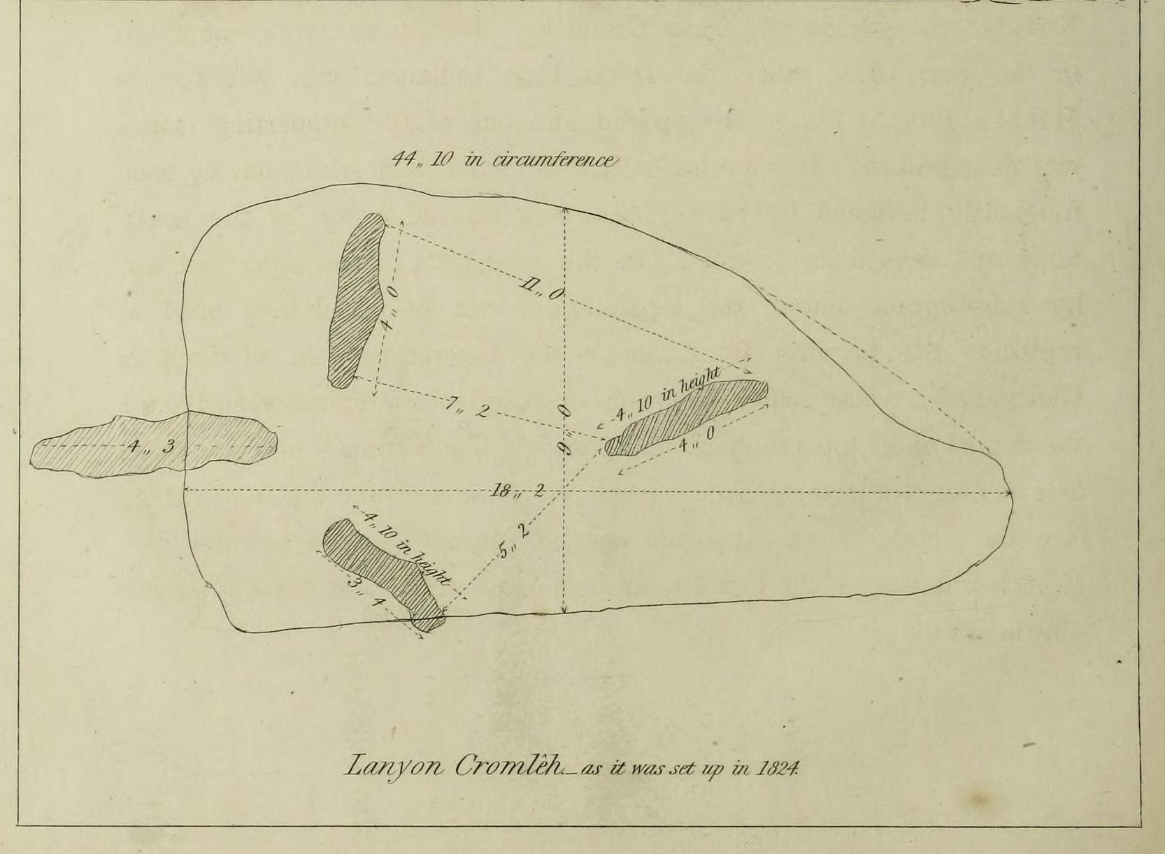
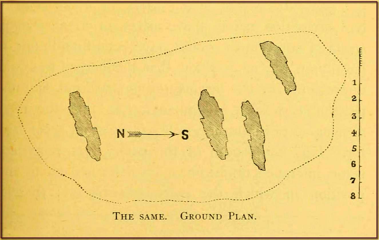
William Borlase 1769 ground-planWilliam Borlase 1769 sketch
Antiquarian Notes
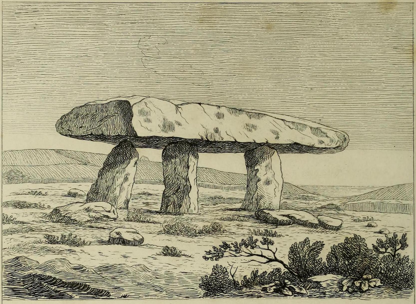
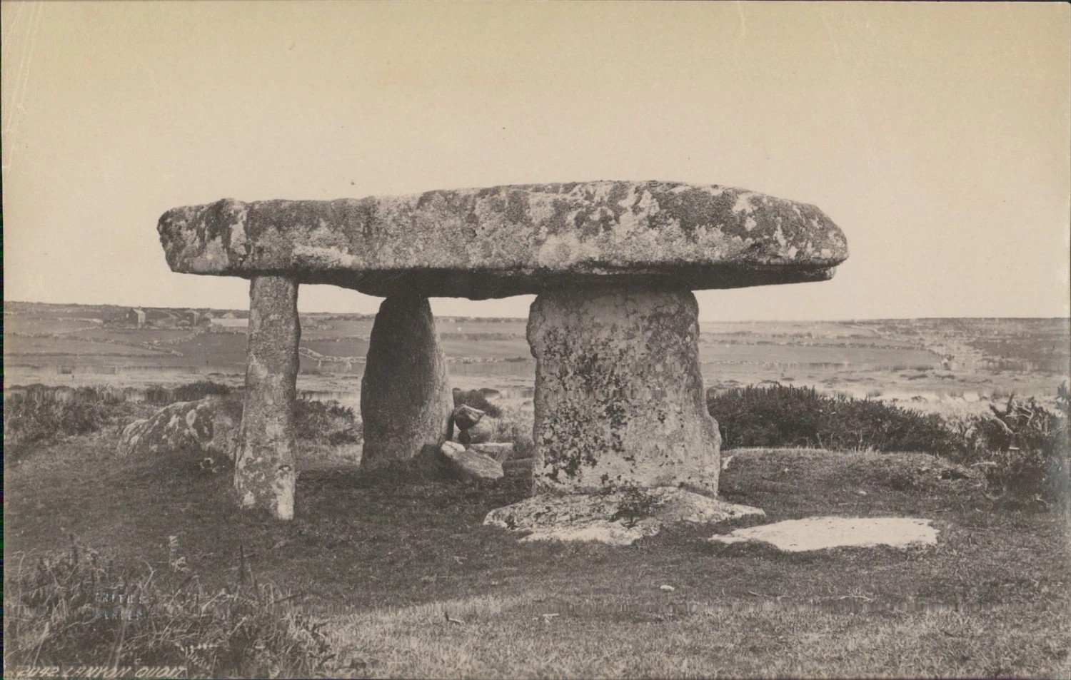
William Cotton, in 1827, told that:
“About a mile and a half north of the church, in the parish of Maddern, and close to the road side, is Lanyon Cromleh, so called from the name of the estate on which it stands. The covering stone, which is nearly flat, and of a triangular figure, measures 44 feet 10 inches in circumference, 18 feet 2 inches in its greatest length, and 9 feet in width, and weighs 15 tons. This Quoit, as it is usually called, was originally supported on four upright stones, describing an open area 7 feet in length, north and south, but not forming an enclosed Kistvaen, like Molfra and Chun Cromlehs. During a very violent storm in the year 1815, when the Delhi East Indiaman was wrecked in Mount’s Bay, it fell to the ground, and one of the supporting stones was then broken. It is probable that the earth beneath it, having been frequently loosened by excavations, was washed away by the heavy rains, and caused its downfal. In the year 1824 it was again set up, by subscription among the inhabitants, with the machinery used in replacing the Logging Rock, under the superintendence of Captain Giddy, R.N., whose zealous exertions overcame every difficulty, and merit the thanks of all topographical antiquaries. The Cromleh now stands as firm as ever: in putting it up, a piece was broken off the top stone, at A, (see the plan). It is supported on three upright stones, each 4 feet 10 inches in height, the tops having been made level, and their positions a little altered.
“This view represents Lanyon Cromleh as it now stands, and differs from all the prints I have seen of it, — which have been uniformly copied from Dr. Borlase’s book, and do not, by any means, give a correct representation. The doctor says, in his time a man on horseback could ride under the incumbent stone — now, its height from the ground is only 4 feet 10 inches. The figures 1824, to mark the year when it was re-erected, have been rudely inscribed on one of the supporting stones.
“Dr. Borlase caused an excavation to be made under this Cromleh, as well as under the last mentioned, but without discovering any human bones ; he was led, however, to conclude, by the appearance of the earth, that a body had been interred there.”
Cotton’s 1827 sketch
Antiquarian Notes
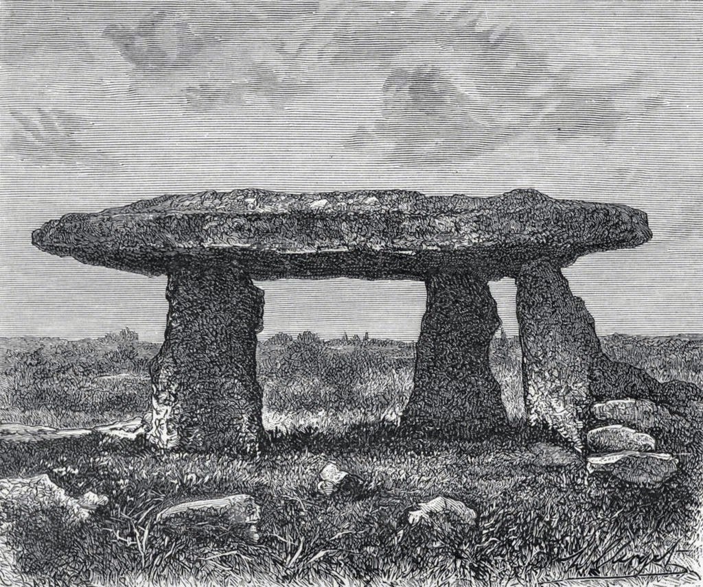
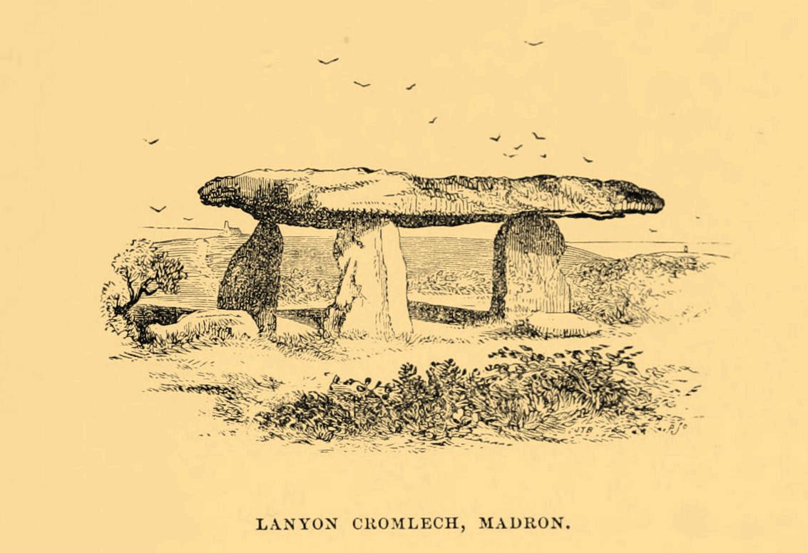
James Orchard Halliwell wrote, in 1861:
“At a distance of some five miles from Penzance, on the road from Madron to Morvah, near the road, on the right-hand side, is the Lanyon Quoit or Cromlech, a fine specimen, and perfect in all essential particulars. The best way of reaching it, if walking, is to take the path to the left in the fields after passing the Madron Union, and keep as nearly in a straight line as possible until the cromlech appears. It is situated in a conspicuous situation in the midst of a wild moor, and is interesting in its Titanic grandeur and vast antiquity. The top covering consists of an enormous flab of granite, supported by three upright unhewn blocks of stone, but near there are three fallen stones, one of which at least was certainly at one time one of the supporters. The dimensions of the cap-stone are thus given by Borlase: —
“This quoit is more than forty-seven feet in girt, and nineteen feet long ; its thickness in the middle on the eastern edge is sixteen inches, at each end not so much, but at the western edge it is two feet thick.”
This cromlech is sometimes called by the country people the Giant’s Quoit, and occasionally the Giant’s Table. My measurement made the covering-stone forty-fix feet in circumference, with a thickness varying from ten to eighteen inches. It is not improbable that the stone has been chipped off at one or two of the corners since the time of Borlase. Between the cromlech and the road are the remains of a stone and earth circular barrow about eighteen feet in diameter. There is an odd tradition that the first battle fought in England was decided in the locality of Lanyon Quoit.”
Blight, J.T., A Week at the Land’s End, Longmans Green: London 1861.
Borlase, William, Antiquities, Historical and Monumental, of the County of Cornwall, Bowyer & Nichols: London 1769.
Borlase, William Copeland, Nænia Cornubiæ, Longmans Green Reader: Truro 1872.
Colquhoun, Ithell, The Living Stones, Cornwall, Peter Owen: London 1957.
Cooke, Ian, Antiquities of West Cornwall – Guide 1, Cornwall Litho: Reduth 2002.
Halliwell, J.O., Rambles in Western Cornwall in the Footsteps of Giants, John Russel Smith: London 1861.
Jewitt, Llewellynn, Grave Mounds and their Contents, Groombridge: London 1870.
Redding, Cyrus, An Illustrated Itinerary of the County of Cornwall, How & Parsons: London 1842.
Russell, Vivien, West Penwith Survey, Cornwall Archaeological Society: Truro 1971.
Straffon, Cheryl, Megalithic Mysteries of Cornwall, Meyn Mamvro: Penzance 2004.
Acknowledgements: Huge thanks for use of the Ordnance Survey map in this site profile, reproduced with the kind permission of the National Library of Scotland.
Stone Circle (destroyed): OS Grid Reference – NO 332 430 (approximation)
Archaeology & History
This stone circle wasn’t logged in either Barnatt (19890 or Burl’s (2000) standard megalith inventories. The only mention of it seems to be in Alex Elliott’s (1911) rare work on the region, in which he described it as being located “within the grounds of Mylnefield”. All trace of it would seem to have gone. Elliott told it to have been,
“elliptical in form and consisted of six large boulders – three at the east, three at the west, with a gap between capable of holding an equal number of stones.”
References:
Elliott Alexander, Lochee – As it Was and As it Is, J.P. Mathew: Dundee 1911.
From Silsden, head up to Brunthwaite village and follow the same directions as if you’re going to see the Brunthwaite (1) cup-marked stone and, once there, look at the walling immediately behind it and you’ll see, at the base of the wall, peeking out is a small earthfast boulder. It’s about a yard away. You’ll find it.
Archaeology & History
Sticking out from the edge of the walling at ground level is this low small cup-marked stone, rediscovered by rock art explorer Tom Cleland just a few weeks ago. It sits behind the cluster of rocks that were dumped here not too many years back. The carving comprises of at least three well-defined and quite deep cups, only two of which were initially visible until we cleared out a third one that had become filled with soil. It’s possible that there’s more of them on the stone, but we’d have to take the wall down to find that out!
The stone seems to be earthfast and may have remained in the same spot, untouched, since when it was first carved four or five thousand years ago—and certainly the depths of the cups suggest that its it’s been pretty much covered over for most of its life. The walling that’s been built on top of it is pretty recent by comparison; but it’s notable that its petroglyphic neighbour, the High Brunthwaite (3) carving, 175 yards to the east, is also an earthfast rock with the field-wall built on top of it.
Its somewhat minimalist appearance reminds me of several of the cup-marked petroglyphs at the top of Shipley Glen, six miles southeast of here, including the Baildon Moor (126) and (130) carvings…
Acknowledgements: Massive appreciation to Thomas Cleland for finding this carving and showing us it’s whereabouts.
Cup-and-Ring Stone (removed): OS Grid Reference – NZ 1475 6350
Archaeology & History
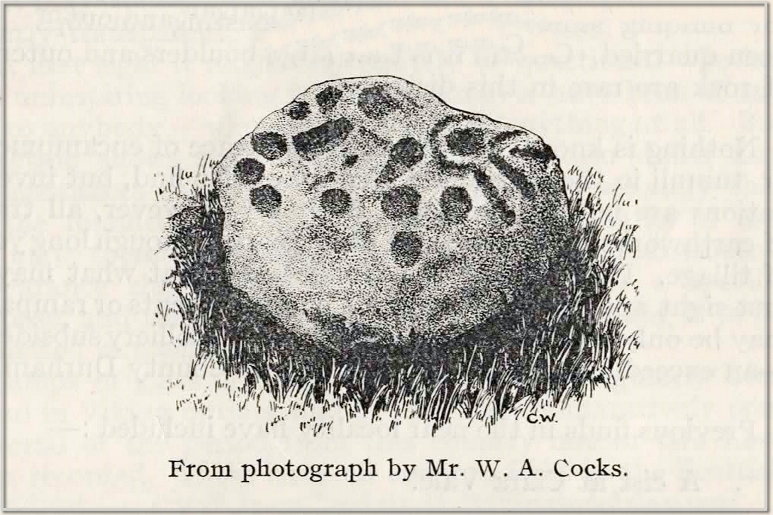
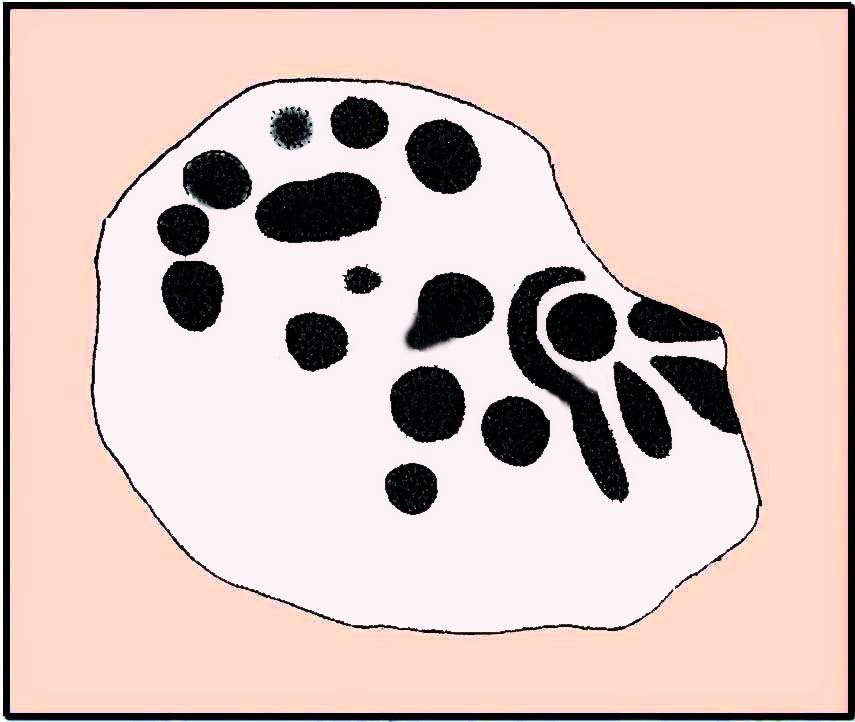
This carving presently lives in what Beckensall & Laurie (1998) described as “the stone store” at the Museum of Antiquities at the University of Newcastle-upon-Tyne, but it was discovered in some walling close to the road on the south-side of Ryton by a Mr William Cocks in 1934. The carved rock is relatively small—measuring “roughly two feet five inches, by one foot ten inches, by one foot three inches in thickness”—and was obviously not in its original position, but would have lived relatively close to the walling into which was placed. Mr Cocks told that,
1934 sketch of the carving
Modified Beckensall sketch
“the stone bears one “cup and ring” with four radial ducts, the latter being in an exceedingly fine state of preservation. There are also ten plain cups of circular form; one cup with a deep conical duct; and one large cup which appears to have been formed by uniting two circular cups. All show the “pocking” or tool marks of manufacture, and these are especially noticeable in the radial ducts.”
The cup-marked Ryton (1) stone was found some 250 yards to the west and the Ryton (3) petroglyph was less than half-a-mile north, making it likely that other types of prehistoric remains once existed in this locale.
References:
Beckensall, Stan, Northumberland’s Prehistoric Rock Carvings – A Mystery Explained, Pendulum: Rothbury 1983.
Beckensall, Stan & Laurie, Tim, Prehistoric Rock Art of County Durham, Swaledale and Wensleydale, County Durham Books 1998.
Cocks, W.A., “The Ryton ‘Cup and Ring’ Marked Rock,” in Proceedings Society of Antiquaries Newcastle-upon-Tyne, volume 6, no.8, 1934.
As you’re going into Silsden up the A6034 road, over the canal bridge, turn right (east) and go up Howden Road for half-a-mile, then go left up Hawber Lane and after 250 yards veer right along Brunthwaite Lane. After nearly another half-mile, through gorgeous High Brunthwaite hamlet and just as the road bends round past the last of the gardens and houses, go through the gate into the field on your right. You’re needing to look at the walling here, which runs alongside the road, but on the field-side, barely 10 yards up. A cluster of rocks has been piled-up against the wall. The largest rounded broken one is the one you’re looking for.
Archaeology & History
Looking across the cups
Discovered recently by the petroglyph explorer Thomas Cleland, this is one of two cup-marked stones in close attendance to each other. It’s nowt special to look at—unless you’re an ardent rock art buff!—as it consists of just two large well-formed cup-marks on its near-vertical face: the most distinct one being some two-inch across and a half-inch deep. The stone was obviously rolled here from very close by and just piled up against the wall and has been broken from a larger piece of rock, but we could see no other cup-marks on the others laid around it (although we couldn’t lift and turn the others over to see if there was anything on their undersides). The earthfast High Brunthwaite (2) cup-marked stone is just a yard away at the base of the wall.
Acknowledgements: Massive appreciation to Thomas Cleland for finding this carving and showing us it’s whereabouts.
Stone Circle (destroyed): OS Grid Reference – NN 9020 0985
Also Known as:
Blackford Glebe
Brookfield House
Archaeology & History
In the 18th Century there stood, on the slight rise of the land about 150 yards south of Brookfield House, one of those “circles of stones…in the glebe”, of the sort that “are supposed to have been places of Druidical worship,” wrote John Stevenson. (1792) Sadly, sometime in the 19th Century, the entire site was uprooted and destroyed, leaving no trace of the place. Not good…. 🙁
References:
Stevenson, John, “Parish of Blackford,” in The Statistical Account of Scotland – volume 3, (edited by, John Sinclair) William Creech: Edinburgh 1792.
From the Cow & Calf car-park, walk towards and past the gigantic Calf rock, swerving round the fallen mass of rocks and into the trees at the back. Walk uphill to the Hanging Stones cup and ring stones, then keep heading—down the slope then back up the next one—west, for barely 100 yards until you’re on the level ground again, following the footpath alongside the heather. Barely 50 yards along, keep your eyes peeled in the heather for a low flat rock just a few yards in. Forage around and you’ll find it.
Archaeology & History
You’ll no doubt be seeing this carving after you’ve visited the impressive Hanging Stones petroglyphs 150 yards to the east. And you’ll probably be disappointed in its lack of visual grandeur when compared to its more ornate eastern neighbour. But the petroglyph fans among you should give it your attention.
Hedges 1986 sketch
Looking to the SE
When the dawn or evening daylight cuts across the rock, the design looks much better than at sun high, perhaps telling us that the message of the stone coincided with those periods of the day. The gentle folds of the stone itself morph into the carving: evening and morning light cutting subtle shadowy folds across the rock, giving it an organic texture that our aboriginal ancestors told to be a vital essence of stone itself. The two small clusters of cup-marks upon this stone become greater than their basic design when brushed with the shadows and glows of a sunset. And when our aboriginal peoples painted them in ochre and other colours, an even greater mythos emerged—but sadly it is forgotten here….
When looked at with the simplistic eyes of the archaeo-mind, this and its compatriots are little more than a number of marks on lifeless rocks. This stone for example was described in John Hedges’ (1986) survey as being just “two groups of four and five cups and grooves”—nothing more—with naught but an echo in Boughey & Vickerman’s (2003) later work. The carving has neighbours even more basic in the heather close by…
References:
Boughey, Keith & Vickerman, E.A., Prehistoric Rock Art of the West Riding, WYAS: Wakefield 2003.
Hedges, John (ed.), The Carved Rocks on Rombalds Moor, WYMCC: Wakefield 1986.
“One of the great level Highland moors stretches away beneath the eye, like a dark waveless lake, contrasting with the distant heights, among which Ben Lawers rears its pyramidal summit to an elevation of upwards of 4000 feet above the level of the sea. Amid this wild Highland landscape the huge standing stones, grey with the moss of ages, produce a singularly grand and imposing effect; and from the idea of lofty height which the distant mountains suggest, they convey a stronger impression of gigantic proportions than is produced even by the first sight of the giant monoliths of Salisbury Plain.”

 I think it’s likely that there would have been more prehistoric sites in the vicinity, but a notable oddity is the almost complete absence of other recorded sites anywhere nearby. Of course, if there was anything, those thoughtful Forestry Commission heads would have destroyed it. We are left, simply, with the old but reliable notes of Messrs Dixon (1923) and Mitchell (1925) who told that, in their days, other remains did exist nearby in the form of ancient cairns and hut circles—‘Pictish’ according to tradition. If we’re lucky, some damaged parts of them might still be found at the edges, a short distance to the north west…
“on the highest part of the moorland…is a group of ‘clachan iobairt’, or stones of worship, where the Druids of old performed their mysterious rites, going round the circle of standing stones from east to west with the sun, or the ‘car deasal’, the lucky side, when they wished to invoke a blessing upon their friends, and going round the circle in the opposite direction, from west to east, the ‘car tuathsel’, or unlucky side, when they wished to pronounce a curse upon their foes.”