Cup-Marked Stone (lost): OS Grid Reference – NH 814 503
Archaeology & History
Somewhere on the outskirts of Kilravock Castle grounds sat (or still sits, hopefully) one of our country’s legendary healing stones bound within the animistic veil of a cup-marked stone. It seems to have fallen off the archaeological registers (if it was ever included!) and so I add it here in the hope that someone can locate it and let us know of its present condition.
Described during a meeting of the Inverness Scientific Society by a Dr Grigor in a short presentation on cup-marked stones at Nairn in July 1884, the matter of some faint traditions concerning a tiny number of cup and ring stones in Scotland was mentioned, and,
“Dr Grigor said he would be able, next day, at the roadside on the Kilravock property, to point out a large rounded stone of gneiss, in the centre of which is a large cut cup-mark of a diameter of six or seven inches which, fifty years ago, was resorted to by many, and water was taken from it long distances. The water was believed to cure skin diseases, but it was principally used for washing warts on the human subject, which it was believed the water quickly removed. It was also particularly in repute for removing warts from cow’s teats.”
The custom described here sounds very similar to others found at so-called ‘Wart Stones’ in England and Scotland (there was one that existed a short distance from where I grew up near Eccleshill, West Yorkshire). Several miles west of here is the cluster of prehistoric carvings in the Clava complex, but this one at Kilravock seems to have fallen off the radar. Does anyone know if it can still be seen? (the grid-reference given to this site is an approximation)
References:
Grigor, Dr, “Cup Marked Stones,” in Transactions Inverness Scientific Society Field Club, volume 3, 1884.
Acknowledgements:Huge thanks for use of the Ordnance Survey map in this site profile, reproduced with the kind permission of the National Library of Scotland.
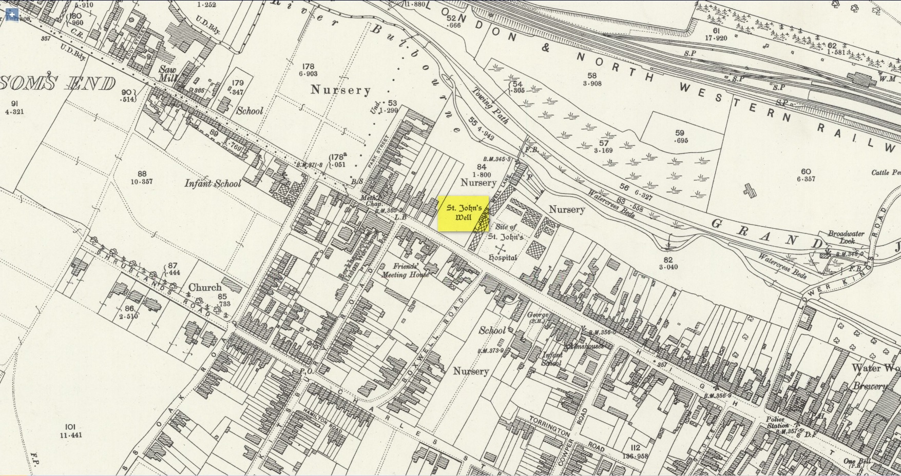
Holy Well (destroyed): OS Grid Reference – SP 9848 0822
Also Known as:
St. James’ Well
Archaeology & History
Site shown on 1897 map
Shown on the early Ordnance Survey maps of the town, Berkhamsted’s holy well was a place of some renown in bygone centuries. Today it is barely remembered. It was initially dedicated to St. James, as it was associated with a chapel dedicated to that saint close by, but it had a change of name when the legendary Brotherhood of St. John the Baptist became the new caretakers, so to speak. As a result of this, its history can be a little confusing to some folk!
In the late 12th century, pagan worship at this site came to the attention of Hugh of Grenoble, the Bishop of Lincoln, who visited the place to stop local folk performing their animistic practices (although the exact nature of such rites were not described, sadly). It didn’t work, obviously; as once the bonkers bishop had gone, local folk would have continued in their old ways, no doubt wondering who the hell the odd incomer had been who was telling them to stop doing what they had always done here at the cost of no one. And so the waters continued to be used under the mythic cover of old St James—for the time being at least.
The well later became a centre of pilgrimage and and a hospital was been built close by dedicated to St James, where leprosy was treated and the curative waters from this well were used. St James’ Day was July 25 and an annual fair was held in Berkhamsted thanks to a Royal Charter of James I in 1619. Hertfordshire traditions relating to St James Day are described in Miss Jones-Baker’s (1974) fine survey on the customs of the county. But change was a-coming when a local monk had a dream that the waters of this “pagan spring” needed to be blessed and dedicated to the virtues of St. John the Evangelist and a shrine built where pilgrims could worship and be healed. And as Jones-Baker (1977) told us,
“The water of St John’s Well were thought to cure a variety of diseases; among these leprosy and scrofula (the King’s Evil) as well as sore eyes. There was also a persistent belief that clothing washed in its waters would impart good health to the wearers.”
In the period when the Protestant Reformation occurred, the well and its immediate surrounds apparently became derelict and overgrown. The Old Ways returned and local folk began to visit the waters again at night and the animistic rituals that would have been taken to other secret places returned to St. John’s Well. In this period a local physician, a Dr. Woodhouse, used the sacred waters as part of magickal rites to exorcise evil spirits!
In spite of the local authorities declaring in 1865 that the water was “unfit for drinking”, local folk later told otherwise. Its waters were still being used in the 20th century and its traditions no doubt retained. As the local writer Dora Fry (1954) told us:
“The families dwelling in the cottages at the Bulbourne end of the lane, just below St John’s Spring, were all remarkably healthy… Some time after the town got its first waterworks (and) the local authorities declared that the well’s water was to be used only for the gardens… but I remember as a child drinking the water from the main spring and its coolness and freshness were delectable on a hot summer afternoon.”
The well was still visible up until the 1930s, when its waters ran down a shallow channel along St John Well’s Lane, but then a shop was built above the site and the well has been lost forever.
References:
Bord, Janet & Colin, Sacred Waters, Granada: London 1985.
Acknowledgements:Huge thanks for use of the Ordnance Survey map in this site profile, reproduced with the kind permission of the National Library of Scotland.
About mile south of Northchurch, on the far side of the A41 dual carriageway, somewhere past the old crossroads (or perhaps even at the crossing) an ancient tree lived—and truly lived in the minds of local people, for perhaps a thousand years or so. Mentioned in the Lay Subsidy Rolls in 1307, the Cross Oak gave its name to the old building that once stood in the trees and the hill itself, at the place now known as Oak Corner. Whether or not a “cross” of any form was set up by this old oak, records are silent on the matter. Its heathen ways however, were pretty renowned! (a plaque should be mounted here)
Folklore
The first reference I’ve found of this place is in William Black’s (1883) folklore survey where he told that “certain oak trees at Berkhampstead, in Hertfordshire, were long famous for the cure of ague”—ague being an intense fever or even malaria. But a few years later when the local historian Henry Nash (1890) wrote about this place, he told that there was only one tree that was renowned for such curative traditions, that being the Cross Oak. He gave us the longest account of the place, coming from the old tongues who knew of it when they were young—and it had it’s very own ritual which, if abided by, would cure a person of their malady. “The legend ran thus”, wrote Mr Nash:
“Any one suffering from this disease was to proceed, with the assistance of a friend, to the old oak tree, known as Cross Oak, then to bore a small hole in the said tree, gather up a lock of the patient’s hair and make it fast in the hole with a peg, the patient then to tear himself from the tree, leaving the lock behind, and the disease was to disappear.
“This process was found to be rather a trying one for a weak patient, and by some authority unknown the practice was considerably modified. It was found to be equally efficacious to remove a lock of hair by gentle means, and convey it to the tree and peg it in securely, and with the necessary amount of faith the result was generally satisfactory. This is no mere fiction, as the old tree with its innumerable peg-holes was able to testify. This celebrated tree, like many other celebrities, has vanished, and another occupies its place, but whether it possesses the same healing virtues as its predecessor is doubtful. It is however a curious coincidence, that the bane and the antidote have passed away together.”
The lore of this magickal tree even found its way into one of J.G. Frazer’s (1933) volumes of The Golden Bough, where he told how the “transference of the malady to the tree was simple but painful.”
Traditions such as this are found in many aboriginal cultures from different parts of the world, where the spirit of the tree (or stone, or well…) will take on the illness of the person for an offering from the afflicted person: basic sympathetic magick, as it’s known. Our Earth is alive!
References:
Black, William G., Folk Medicine, Folk-lore Society: London 1883.
Frazer, James G., The Scapegoat, MacMillan: London 1933.
Jones-Baker, Doris, The Folklore of Hertfordshire, B.T. Batsford: London 1977.
Nash, Henry, Reminiscences of Berkhamsted, W. Cooper & Nephews: Berkhamsted 1890.
Acknowledgements:Huge thanks for use of the Ordnance Survey map in this site profile, reproduced with the kind permission of the National Library of Scotland.
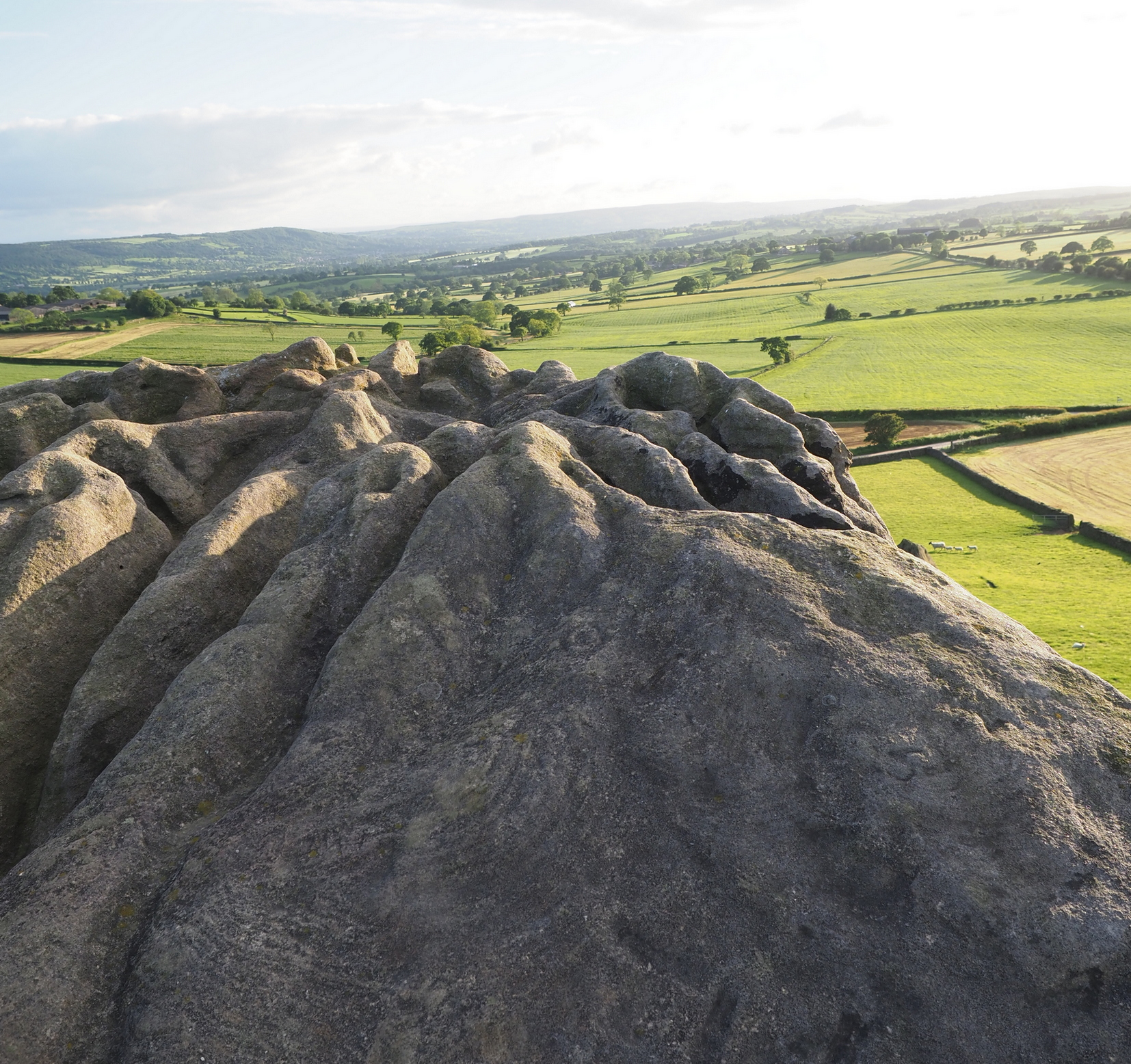
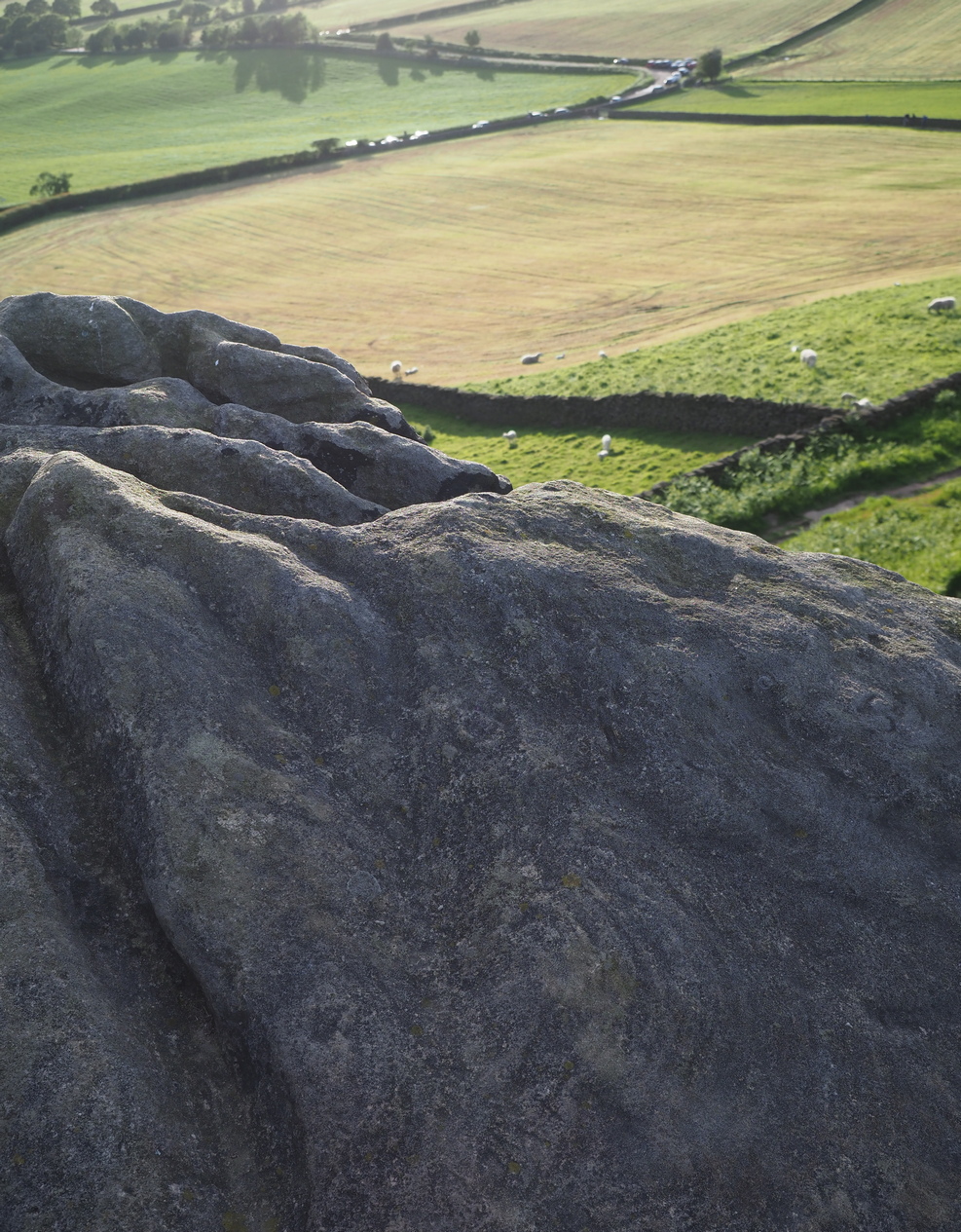
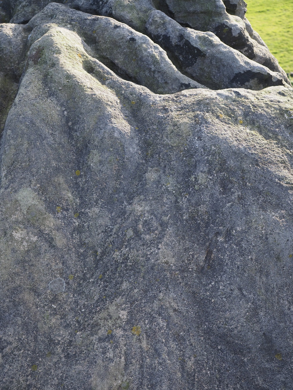
This is an outstanding site visible for miles around in just about every direction – so getting here is easy! If you’re coming from Harrogate, south down the A658, turn right and go thru North Rigton. Ask a local. If you’re coming north up the A658 from the Leeds or Bradford area, do exactly the same! (either way, you’ll see the crags rising up from some distance away) As you walk to the main crags, instead of going to the huge central mass, you need to follow the line of walling down (south) to the extended cluster of much lower sloping rocks. Look around and you’ll find it!
Archaeology & History
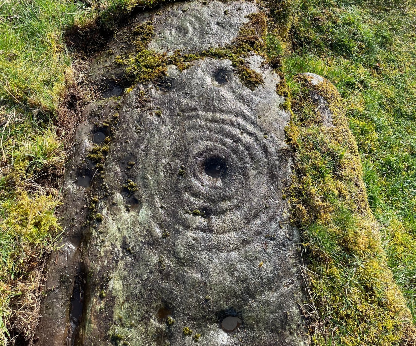
On the evening of May 27, 2024, I received a phone call from a Mr James Elkington of Otley. He was up Almscliffe Crags and the wind was howling away in the background, taking his words away half the time, breaking the sentences into piecemeal fragments. But through it all came a simple clarity: as the sun was setting and the low light cut across the rocky surface, a previously unrecorded cup-and-ring design emerged from the stone and was brought to the attention of he and his compatriot Mackenzie Erichs. All previous explorations for rock art here over the last 150 years had proved fruitless—until now!
Looking northwestCentral cup-&-ring
On the east-facing slope of the stone, just below the curvaceous wind-and-rain hewn shapes at the very top of the boulder, is a singular archetypal cup-and-ring. It’s faint, as the photos show, but it’s definitely there. What might be another cup-and-ring is visible slightly higher up the sloping face, but the site needs looking at again when lighting conditions are just right! (you can just about make it out in one of the photos) But, at long last, this giant legend-infested mass of Almscliffe has its prehistoric animistic fingerprint, bearing fruit and giving watch to the countless heathen activities going back centuries. Rombald’s wife Herself might have been the mythic artist of this very carving! (if you want to read about the many legends attached to the major Almscliffe rock outcrop, check out the main entry for Almscliffe Crags)
On the A81 road from Aberfoyle to Strathblane, about a mile south of Aberfoyle take the tiny right turn (keep your eyes peeled!) to Gartmore. Along the tiny curving road for exactly 1km (0.61 miles), where the road has straightened out there’s a small dirt-track with a parking spot along it. A few hundred yards along there’s a crossroads of dirt-tracks: walk to your left (SW) for nearly a mile (or exactly 1.5km) keeping your eyes peeled for a small distinct footpath leading down-slope on your left. Walk along this undulating path for just over 200 yards till you go through the gate, then walk immediately to your right down the side of the fence in the field for about 20 yards. Y’ can’t miss it!
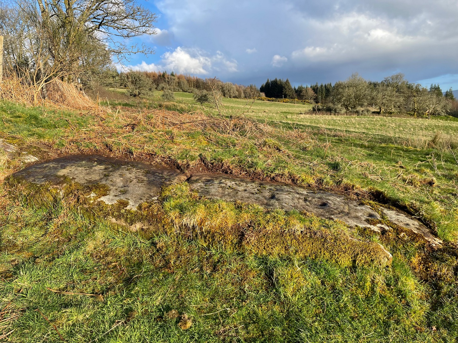
Archaeology & History
Blarnaboard (3), NE-SW
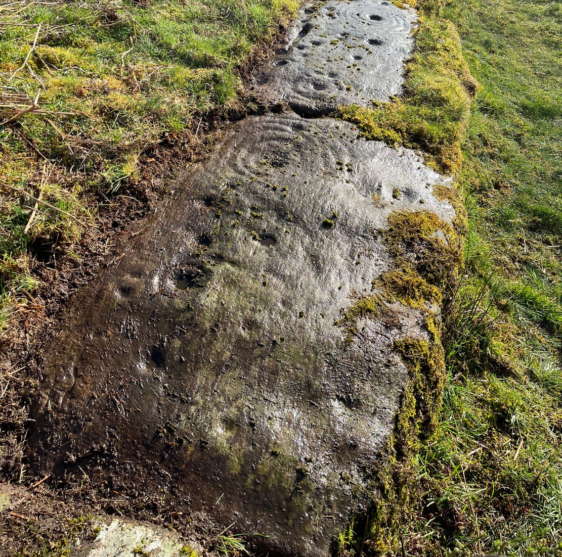
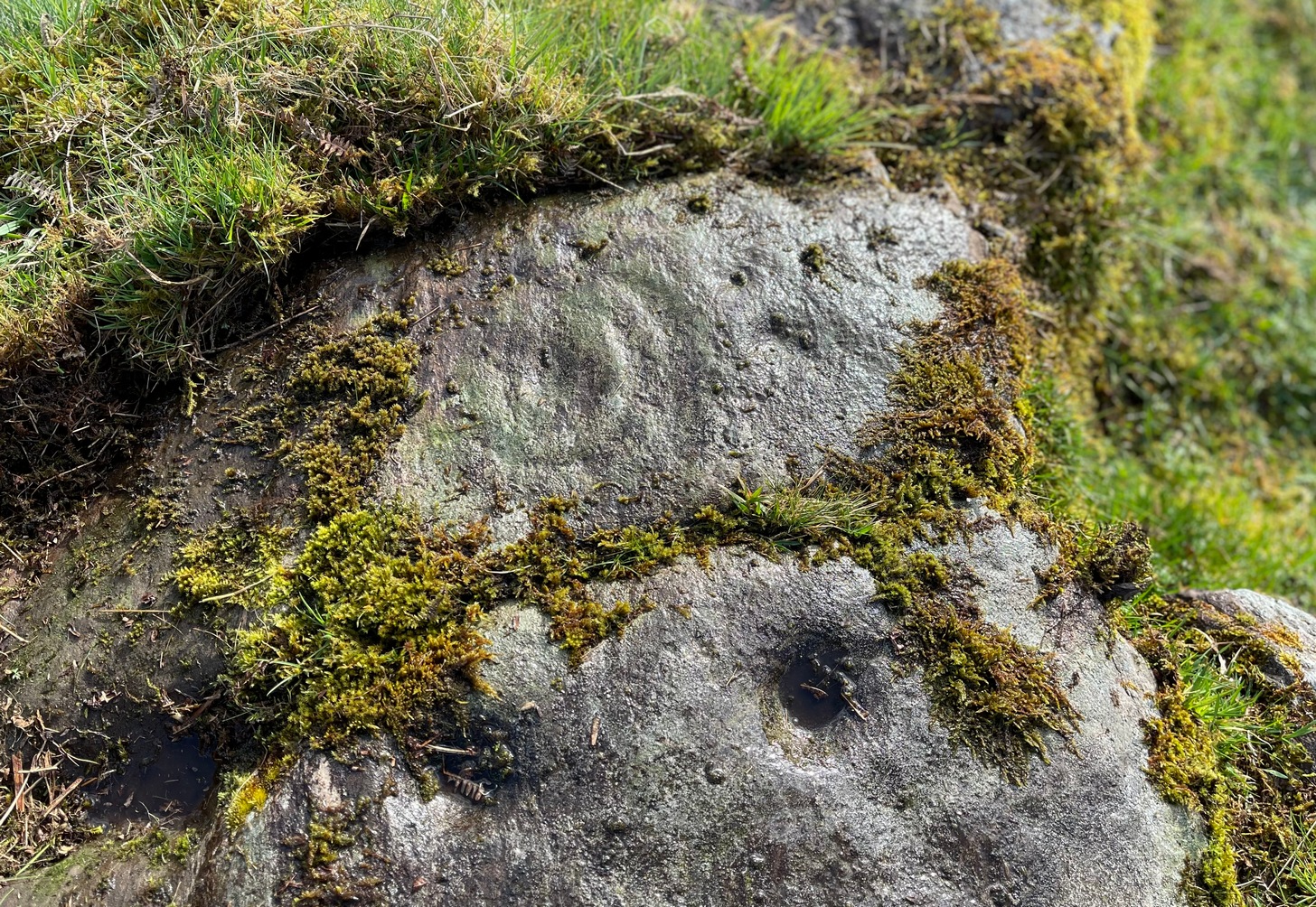
Located on the land of the early bards of Gartmore, we could speculate that those early orators told tales of, and from this old stone—but that’s all it would be: dreamy speculation. Instead, passing that aside, the petroglyph itself brings us a feast to drool over!
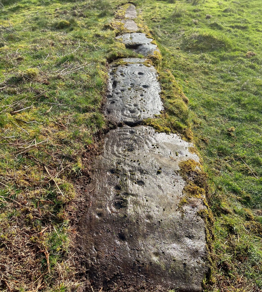
Made up of four distinct carved sections of almost interconnecting rock, this flat thin line of stone is covered with an impressive array of cups and multiple rings. Running downhill in a northeast to southwest line, it would appear to have been written about for the first time by Lorna Main (1988) who subsequently described it in the usual archaeological shorthand, simply telling that,
“There are at last 28 cups, 3 cup and one ring, 4 cup and two rings, 2 cup and three rings, 1 cup and five rings and 1 cup and seven rings.”
Multiple ringed elementSection 1 overview
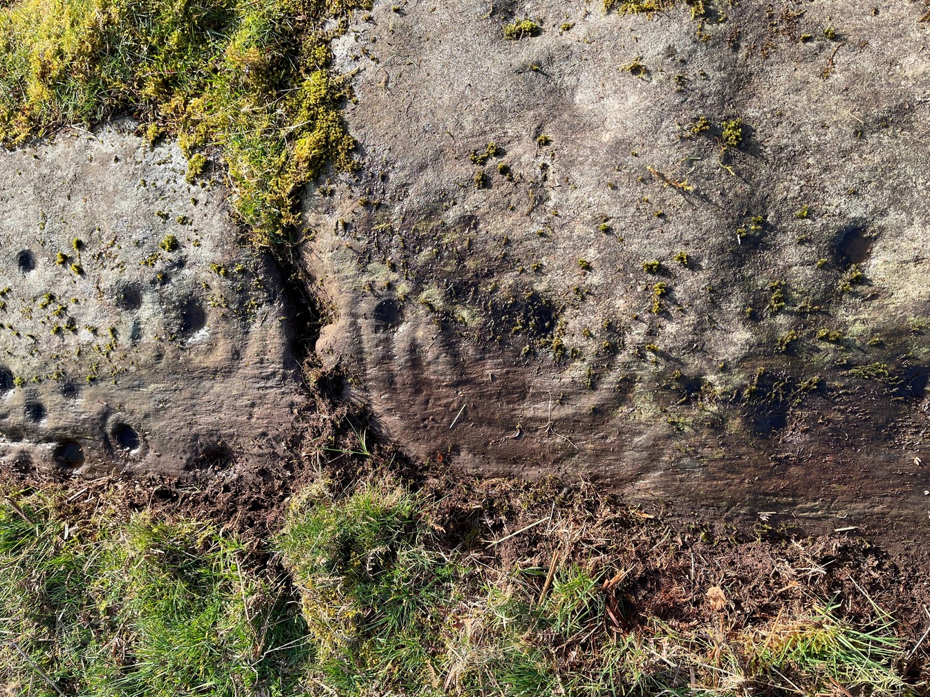
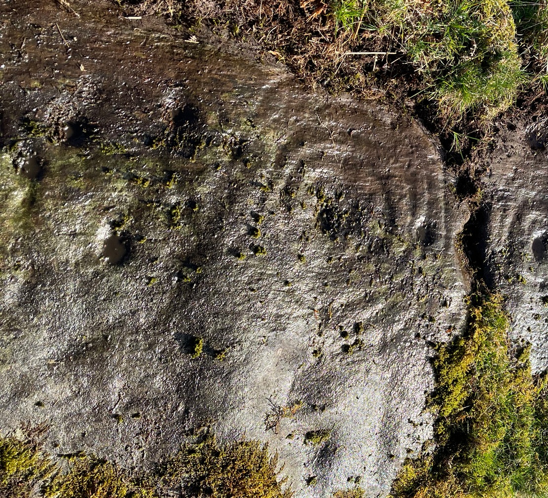
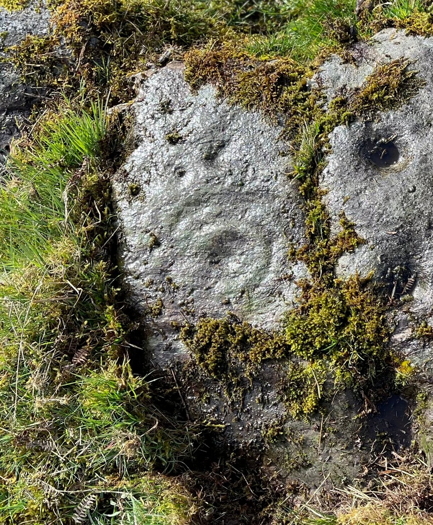
…But, as usual, there’s much more to be said of it than that. Of the four sections, we’ll start at the uppermost northeastern section and work down the sloping ridge, looking at the respective symbols as we go. Section 1 has the largest surface area, but isn’t the most decorated of the bunch. Nonetheless, what we find here is impressive. About a dozen single cup-marks of various ages are scattered over the surface in what initially seems to be no recognizable order; these are accompanied by two single cup-and-rings: one of which could be said to be of standard size and form, whilst the other has a much larger and broken ring, near the middle of the rock, about 12 inches across. This larger ring has two or three of the cup-marks incorporated into its outer edges. The most impressive element of Section 1 is the large multiple-ringed design, five in all, radiating outwards or funneling inwards (depending on what was intended) around a central cup. The outer ring of this is incomplete.
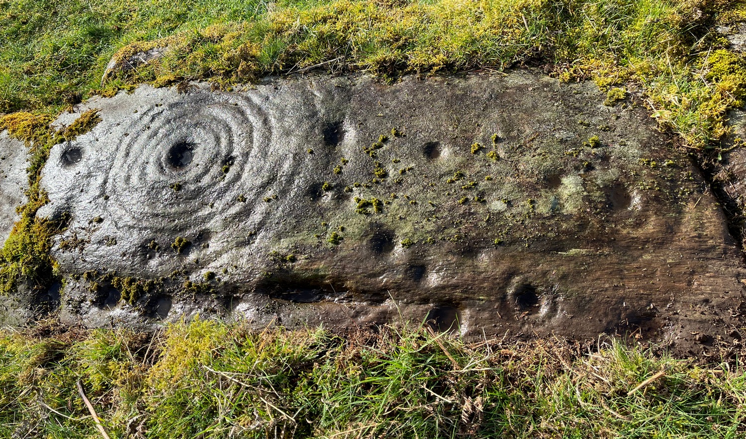
Impressive cup & 7 ringsScatter of cups & rings
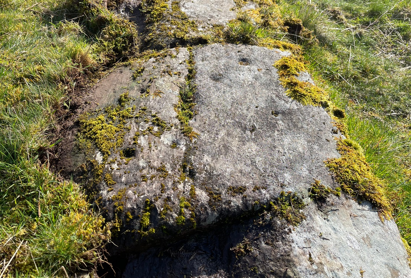
Section 2 is the most visually impressive of all the Blarnaboard (3) carvings: almost an evolutionary development of what we see on the first part. A 2-dimensional panorama shows off a distinct cup-and-ring close to the edge of the soil, and there’s a somewhat wonky incomplete cup with double-ring below it. A very clear cup-mark to the right of this has another faint incomplete double-ring round it—but this is hard to see. The same cannot be said of the cup with seven concentric rings surrounding it! (the outer two of these are incomplete) As I walked round and round this section, drooling somewhat, it became obvious that a number of well-defined cup-marks had been carved around the outer edges of the rings, deliberately creating an eighth ring comprised purely of cup-marks. It gave me the impression of it representing heavenly bodies revolving around the central Pole Star; but also of it defining the movement of the Moon through the heavens during a calendar year. (the astronomy of my youth still comes through at times!)
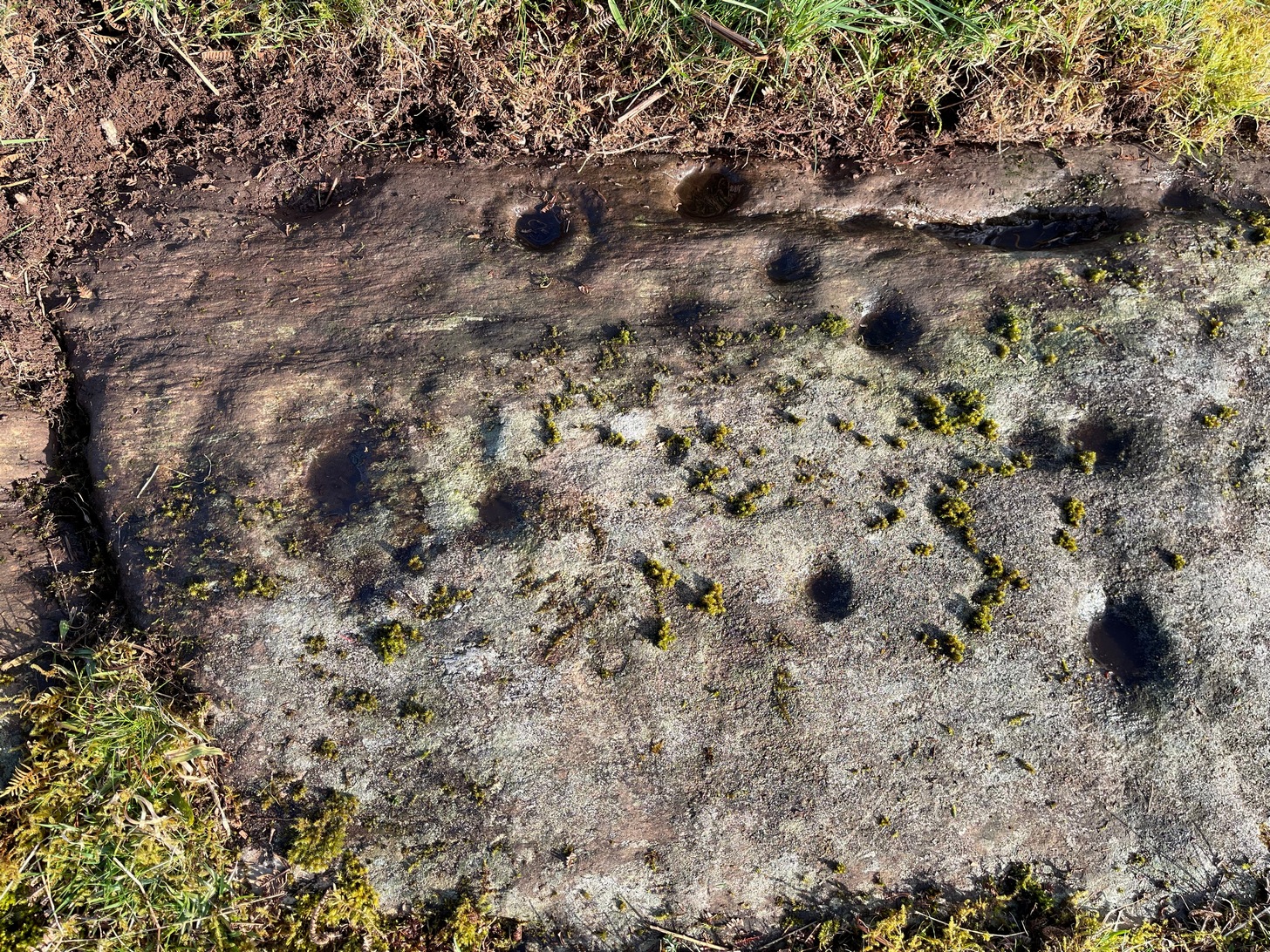
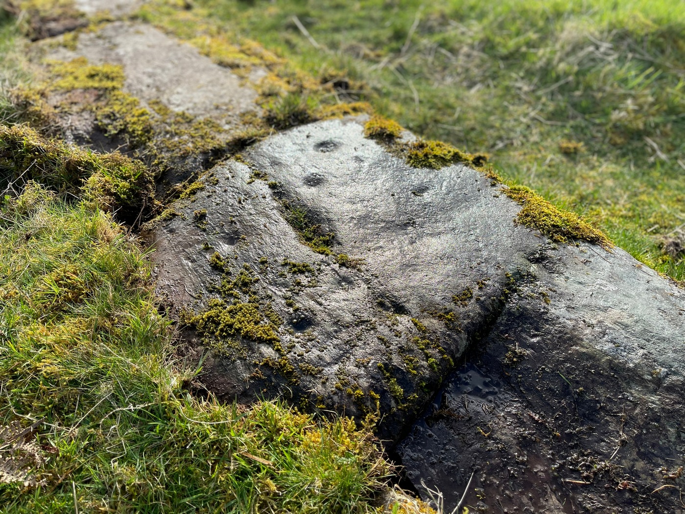
Section 3 carvingFaint double cup-and-ring
By comparison, the third and smallest section of Blarnaboard (3) almost pales into insignificance, possessing a mere cup-and-double-ring—and a very faint one at that. From a certain angle it looked like it possessed a third ring, but this was probably more to do with me wanting to see more than there is! Just below this double-ring, a single cup has what might have once been another incomplete ring round it—but we’d need the computer graphic students among you to suss that bit out! You can’t make it out on the photos here, sadly…
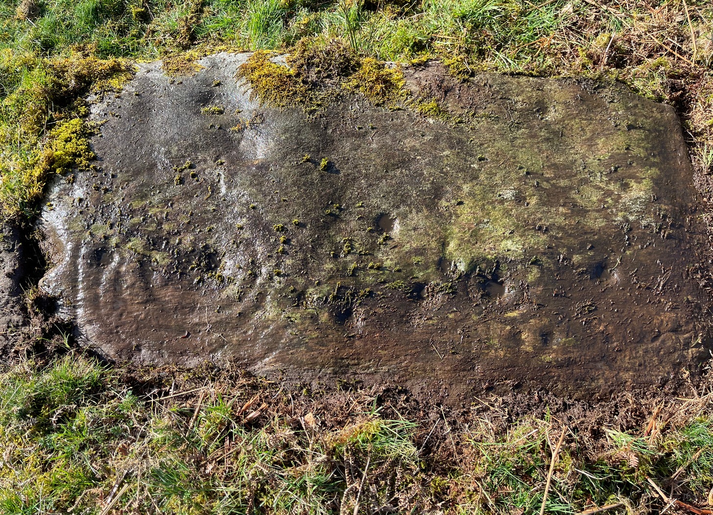
Section 4 carvingFaint double-arc, lower cup
The fourth section is the most visually unimpressive of the entire cluster and was probably carved much later than the rest. The poor little fella has just five single cup-marks, with a sixth at the top-corner or northeastern part with what seems to be a small carved double-arc, or partial lozenge, that was started and never finished.
A couple of other exposed sections of stone running a few more yards further down the same line have no carvings on them—but there may well be more to this petroglyph hiding beneath the turf, which covers quite a large area. I have no doubt that other unrecorded carvings exist in close by, but due to excessive forestry plantations all around here, they’ll either be covered over or will have been destroyed. Don’t let this put you off looking for others though!
Cup-and-five-ringsCup-and-seven rings
An interesting feature of this long line of stone is its potential alignment. When we were photographing the site, a local man came over and got chatting with us. He knew of the carving and had been here many times and told us that his wife had looked at this one and found it aligned with another cup-and-ring on the south-side of Blarnaboard farm and another one (officially unrecorded) even further along. I checked this when I got home and found that this long line of petroglyphs did indeed line up with the Blarnaboard farm carving, perfectly. Whether this was intentional and/or possesses an astronomical function, we might never know. The third carving along the line has yet to be located. I must emphasize however, that the relationship between earthfast petroglyphs and alignments is very rare and, where found, is little more than fortuitous. But when we find cup-markings on alignments of standing stones and other prehistoric monuments, the relationship seems to be much more intentional and would have had a specific mythic function.
If y’ follow the fence-line from this carving down to the small burn, on the other side is the much less impressive Blarnaboard (2) cup-marked stone.
Folklore
Prior to Lorna Main’s (1988) short note on this petroglyph, local people had long known about the carving. As late as the 20th century, people with fevers were brought to this stone in the early morning to be cured of the illness. The idea was that medicinal herbs were collected and placed in some of the cup-marks, which were used like a mortar and pestle to prepare the plants. This healing magick, spoken of by some of the old folk in Aberfoyle, was known to them as children, who’d been told of this by their elders and, of course, by the elders before them.
There is also a tradition that some of the stone that makes up the curious moondial (not sundial) that can be seen at the back of the church in Gartmore village nearly a mile to the southeast, originally came from here.
References:
Main, L., “Blarnaboard (Aberfoyle parish), Cup and Ring Marked Outcrop,” in Discovery & Excavation Scotland, 1988.
Acknowledgements:Huge thanks for use of the Ordnance Survey map in this site profile, reproduced with the kind permission of the National Library of Scotland.
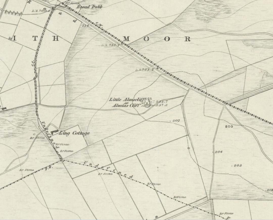
Coming from Harrogate, take the B6162 and B6161 road to Beckwithshaw, through the village and, 4-500 yards on, turn right onto Norwood Lane. 2 miles along, keep your eyes peeled on your left for a gravelled parking spot and you’ll see the large rock outcrop 200 yards south of the road. …Otherwise, from Otley: go over the river bridge and turn right up Farnley Lane and follow the B6451 for a few miles, thru Farnley village up the Washburn valley, past Norwood and at Bland Hill, turn right along Broad Dubb Road for 1¾ miles where you’ll reach that same gravelled parking spot.
Archaeology & History
Very much the ‘little brother’ of Great Almscliffe, 3 miles (4.83km) to the southeast, this site would be more of interest to the travelling geologist, perhaps, than to antiquarians. But that depends what tickles y’ fancy I s’ppose.
In 1702 when the northern antiquarian Ralph Thoresby mentioned this and its big brother to the southeast, he described the “two famous crags of Almes Cliff—in some old writings called Aylmoys ut dicitur—but have seen nothing memorial of it, saving its remarkable lofty situation.” He missed the cup-and-ring carving on the east-side of the crags, obviously, which indicates that it had some form of animistic sanctity in ancient times.
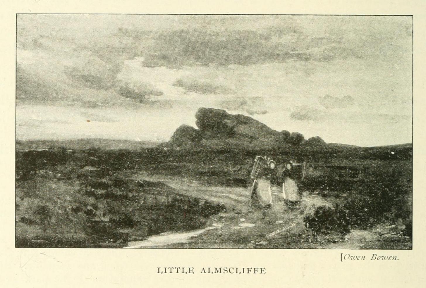
The location on 1851 mapLittle Almscliffe c.1900
Little Almscliffe was one of many impressive places located within the ancient Forest of Knaresborough; and although it wasn’t on the original boundary line, a perambulation (i.e., annual ritual walking to the old stones, trees and wells defining the region) of the area written in 1770, in what Mr Grainge called “the Copyhold Forest”, was undertaken by the Enclosure Commissioners. It differed from the more ancient perambulation rite, in that the newer one included a mention of,
“five bounder stones also marked F to an earth-fast stone, lying northeast of Little Almes Cliffe, marked also with an F; (and) from thence by other four bounder stones marked F to Sandwith Wath…”
The letter ‘F’ here signifying the word ‘forest’, as in the Forest of Knareborough.
William Grainge (1871) also believed these crags to have been a place of druidic worship. He wasn’t the only one. Many other writers of the time thought the same thing; and although we have no concrete evidence to prove this, it is highly likely that these rocks would have served some ritual purpose in pre-christian days. Certainly in more recent times (during the 1980s and ’90s) we know that ritual magickians used this site for their workings. On a more mundane level, the crags were previously used as a site for for beacon fires. One was erected here in 1803 when the first Bonaparte threatened to invade England; but I can find no written accounts of earlier beacons here.
References:
Bennett, Paul, The Old Stones of Elmet, Capall Bann: Milverton 2001.
Bogg, Edmund, From Eden Vale to the Plains of York, James Miles: Leeds 1895.
Bogg, Edmund, Higher Wharfeland, James Miles: Leeds 1904
Cowling, E.T., Rombald’s Way, William Walker: Otley 1946.
Grainge, William, History & Topography of Harrogate and the Forest of Knaresborough, J.R. Smith: London 1871.
Parkinson, Thomas, Lays and Leaves of the Forest, Kent & Co.: London 1882.
I’ve already added a site-profile of the standing stones that used to be close to this loch, and added to it the folklore below; but I realised that for students of water-lore, a separate profile for the loch itself is needed. For those of you who are not into water-lore, I hope you can forgive this repetition.
The loch, its associated chapel and the standing stones were visited at the end of the 17th century by John Brand, who gave a good account of the rituals performed by local people at the time. They regarded the waters here as very special indeed, with great medicinal powers. The loch had sense of sacrality whose nature was intimately tied to the repetition and regeneration of the seasons, valorizing the healing function of the waters.
By the edge of the loch stood St Tredwell’s church, outside of which was a cairn of stones. When people visited here to be cured of their various ailments, they would pick up one of them and cast it into the loch as an offering (some folk would cast money), so that its waters would heal their illness. According to Mr Brand and the local minister, such cures were numerous. The narrative is truly fascinating. Brand told us that,
“nigh to the east end of which this chapel is, is held by the people as medicinal, whereupon many diseased and infirm persons resort to it, some saying that thereby they have got good; as a certain gentleman’s sister upon the isle, who was not able to go to this loch without help, yet returned without it; as likewise a gentleman in the country who was much distressed wifh sore eyes, went to this loch, and washing there became sound and whole, though he had been at much pains and expense to cure them formerly. With both which persons he who was minister of the place for many years was well acquainted, and told us that he saw them both before and after the cure. The present minister of Westra told me that such as are able to walk, use to go so many times about the loch as they think will perfect the cure, before they make any use of the water, and that without speaking to any, for they believe that if they speak this will marr the cure: also he told that on a certain morning not long since he went to this loch and found six so making their circuit, whom with some difficulty he obliging to speak, said to him they came there for their cure.”
For the curing of sore eyes, the loch was specifically resorted to at Easter and during Lent. Traditions such as these are found at other lochs in Scotland and at lakes in many other parts of the world.
Another interesting feature related to the element of Kingship; for the waters of the loch were said to turn red when anything important was going to happen to a member of the royal family.
St Tredwell herself—also known as St. Triduana—has her saints day on October 8.
References:
Banks, M. MacLeod, British Calendar Customs: Orkney and Shetland, Folk-lore Society: London 1946.
Black, G.F., Examples of Printed Folk-lore Concerning the Orkney and Shetland Islands, Folk-Lore Society: London 1901.
Brand, John, A Brief Description of Orkney, Zetland, Pightland Firth and Caithness, George Mosman: Edinburgh 1701.
Eliade, Mircea, The Sacred and the Profane, Harcourt: New York 1959.
Fergusson, Robert M., Rambling Sketches in the Far North, Simpkin Marshall: London 1883.
MacKinlay, James M., Influence of the Pre-Reformation Church on Scottish Place-Names, William Blackwood: Edinburgh 1904.
Standing Stones (destroyed): OS Grid Reference – HY 497 509
Archaeology & History
These long lost standing stones most probably played a part in some ritual acts performed by the Orkney people until relatively recent times. Whilst their simple description doesn’t tell us this, the folklore of the adjacent body of water strongly suggests it. The stones were visited at the end of the 17th century by the antiquarian John Brand (1701) from whom we gain the only known account. He told that,
“At the north-east side of (St Tredwell’s) loch, nigh to the chapel, there is a high stone standing, behind which there is another stone lying hollowed in the form of a manger, and nigh to this there is another high stone standing with a round hole through it, for what use these stones served, we could not learn; whether for binding the horses of such to them as came to the chapel, and giving them meat in the hollow stone, or for tying the sacrifices to, as some say, in the times of Pagan idolatry, is uncertain.”
Several other hold stones are found in Orkney, some of which had lore that was thankfully recorded. We don’t know when these stones were torn down, but there is the possibility that they may have been cast into the loch alongside which they stood.
Folklore
An intriguing piece of folklore relates to the adjacent St Tredwell’s Loch, right next to the stones. The loch was known of far and wide as possessing great healing properties which Mr Brand told to be distinctly pagan in nature. St Tredwell’s church had a cairn of stones by its side and those who visited here would pick one up and cast it into the loch as an offering (some folk would cast money), so that its waters would heal that person’s ailment. According to Brand and the local minister, such cures were numerous. The narrative is truly fascinating. Brand told us that,
“nigh to the east end of which this chapel is, is held by the people as medicinal, whereupon many diseased and infirm persons resort to it, some saying that thereby they have got good; as a certain gentleman’s sister upon the isle, who was not able to go to this loch without help, yet returned without it; as likewise a gentleman in the country who was much distressed wifh sore eyes, went to this loch, and washing there became sound and whole, though he had been at much pains and expense to cure them formerly. With both which persons he who was minister of the place for many years was well acquainted, and told us that he saw them both before and after the cure. The present minister of Westra told me that such as are able to walk, use to go so many times about the loch as they think will perfect the cure, before they make any use of the water, and that without speaking to any, for they believe that if they speak this will marr the cure: also he told that on a certain morning not long since he went to this loch and found six so making their circuit, whom with some difficulty he obliging to speak, said to him they came there for their cure.”
The reason that I’ve included this folklore to the site profile of the monoliths is that, at some time in the early past the stones would most almost certainly have played some part in the ritual enacted at the loch by which they stood. The building of Tredwell’s chapel was, quite obviously, an attempt to mark the place as christian in nature; but in such a remote region, old habits truly died hard. Of particular interest in the rituals described here is the element of silence. It’s fascinating inasmuch as it’s an integral ingredient in various ritual magick performances in different parts of the world. Even in some modern magickal rites, this is still vitally important. It’s a tradition also found at other lochs in Scotland and at lakes in many other parts of the world.
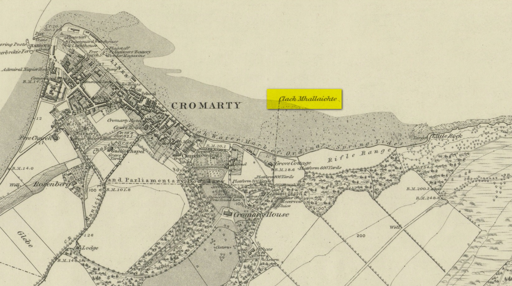
This large boulder found off the Cromarty coast, was highlighted on the 1880 OS-map of the region. It is one of the ancient boundary stones of the township.
Folklore
We know from the vast array on the folklore of stones that many were imbued with magickal abilities, some of which were witnesses to vows and others to make curses from. This large boulder off the coast of Cromarty was, according to Donald MacKenzie (1935), a place where the latter used to be done. He told us:
“At Cromarty there is a big boulder known as the Clach na Mallachd (‘Stone of Cursing’). Curses were delivered when an individual stood or knelt bare-kneed upon it.”
In an earlier account by the Ordnance Survey lads in one of their Name Books, they gave the following tale that had been narrated to them:
“A large stone Situate at the Low Water, and forming one of the boundary Stones of the burgh, the reason of its having this name is, that a young lad while Sitting on it was overwhelmed by the advancing tide and drowned, his mother when told of it, cursed the stone, hence the name Clach Mallach (Accursed Stone)”
References:
MacKenzie, Donald A., Scottish Folk-lore and Folk Life, Blackie: Glasgow 1935.
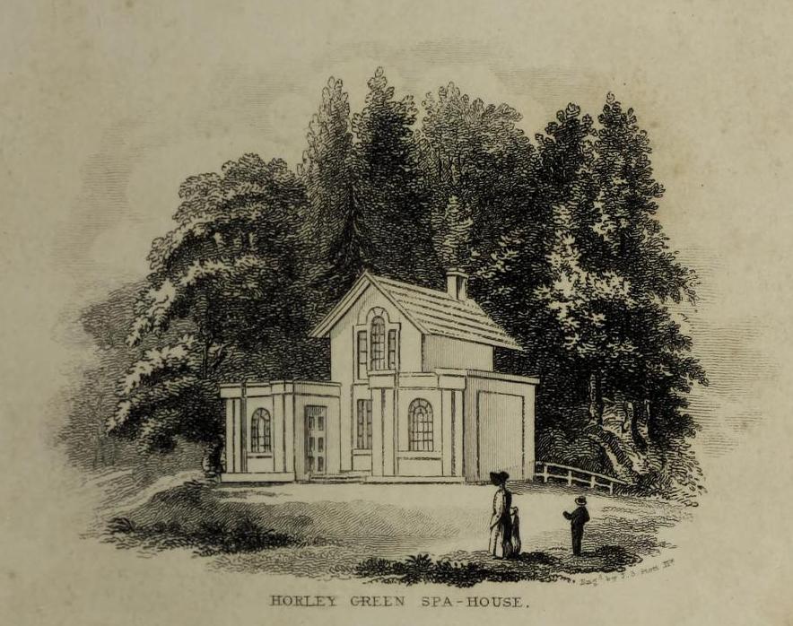
The historian William Addison (1951), in his history on the subject, told how “the spas began as holy wells”; and although no direct accounts are left of early dedications here, the remnants of Mayday traditions tell us there were more archaic goings-on before the waters were taken by the aristocrats. Once it had been designated as a spa, the waters were covered and a typical Spa House constructed over them. From hereon, for more than a century, the waters were accessible only to those with money who wished their ailments to be treated.
Between the end of the 18th to the end of the 19th century, the Horley Green Spa was a very prominent ingredient in the history of Calderdale. A chalybeate or iron-bearing spring, its waters were directed into a large underground cistern covered by metal. Thomas Garnett (1790) was the first to write about it, telling us:
“The Horley Green water is quite pellucid—sparkles when poured out of one glass into another—and has a sharp, aluminous, styptic taste, not unlike ink. The taste is not unpleasant when the water is taken from the springhead and drank immediately.”
He went on to espouse the waters to be good in healing bone and rheumatic diseases, giving many first-hand accounts from people in Yorkshire and beyond who used the waters here with apparent success, including one case of curing diabetes! Its reputation was later reinforced in a book by William Alexander (1840), who told us how,
“I unhesitatingly affirm that the Horley Green Spa possesses a very strong claim to be regarded as a powerful tonic and chalybeate.”
By the time those words were written, it had already gained a considerable reputation and many were those who’d received treatment.
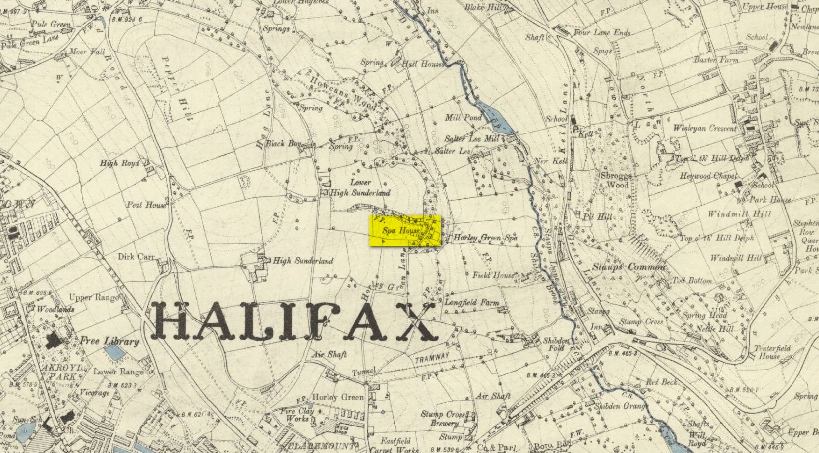
Spa House on 1894 map
A years after Alexander, the roving doctor A.B. Granville (1841) visited Horley Green—who described it as “a renowned steel-water Spa”. But at the same time he reported how its popularity had started to decline. But, via one Mr West, he did leave us with a greater chemical analysis of the Horley Green waters in an attempt, once more, to certify and prove its curative properties. Their results found the waters to possess, in varying quantities, lime, magnesia, silica, iron oxide, sulphur and silica—all of which further attributed the science of its medicinal actions. A number of case histories of the people cured here can be found in the works of Granville, Garnett and Alexander.
The well-house that stood here eventually fell into disuse. When it was eventually restored as someone’s home in the the late 20th century, the disused spring was found beneath the foundations, filled with stones.
Folklore
Horley Green’s spa well came about as a result of local people visiting the site around Beltane, probably for centuries before the aristocrats and early pharmacists took their hand to the place. But once the spa became renowned, people could only gather here “on the first Sundays in the month of May,” with Sunday being that legendary ‘day of the lord’ crap, to which the people would abide to save them from prosecution. It is obvious though that it had been used as a place of magick thanks to the snippets of lore which have found their way into local history books. We read how, at 6am, people gathered here, to such an extent that the roads were completely crowded. Those who arrived first were given bags of nuts: an archaic traditional motif found at many pre-christian wells in Britain. Occultists and ritual magickians amongst you will note the time when folk frequented the well, at 6am: the time when many nature-spirits are invoked for full effects. We find this time echoed in the ritual gatherings at Lady or St. Anne’s Well in Morley, just a few miles to the east.
References:
Addison, William, English Spas, Batsford: London 1951.
Alderson, Frederick, The Inland Resorts and Spas of Britain, David & Charles: Newton Abbot 1973.
Alexander, William, “On the Mineral Springs of the Parish of Halifax,” in Proceedings Geological & Polytechnic Society, West Riding, Yorkshire, volume 1, Edward Baines: Leeds 1849.
Crabtree, John, Concise History of the Parish and Vicarage of Halifax, Hartley & Walker: Halifax 1836.
Granville, A.B., Spas of England, Henry Colburn: London 1841.
Hembry, Phyllis, The English Spa 1560-1815, Athlone Press: London 1990.
Short, Thomas, The Natural, Experimental and Medicinal History of the Mineral Waters of Derbyshire, Lincolnshire and Yorkshire, privately printed: London 1724.
Short, Thomas, A General Treatise on Various Cold Mineral Waters in England, privately printed: London 1765.