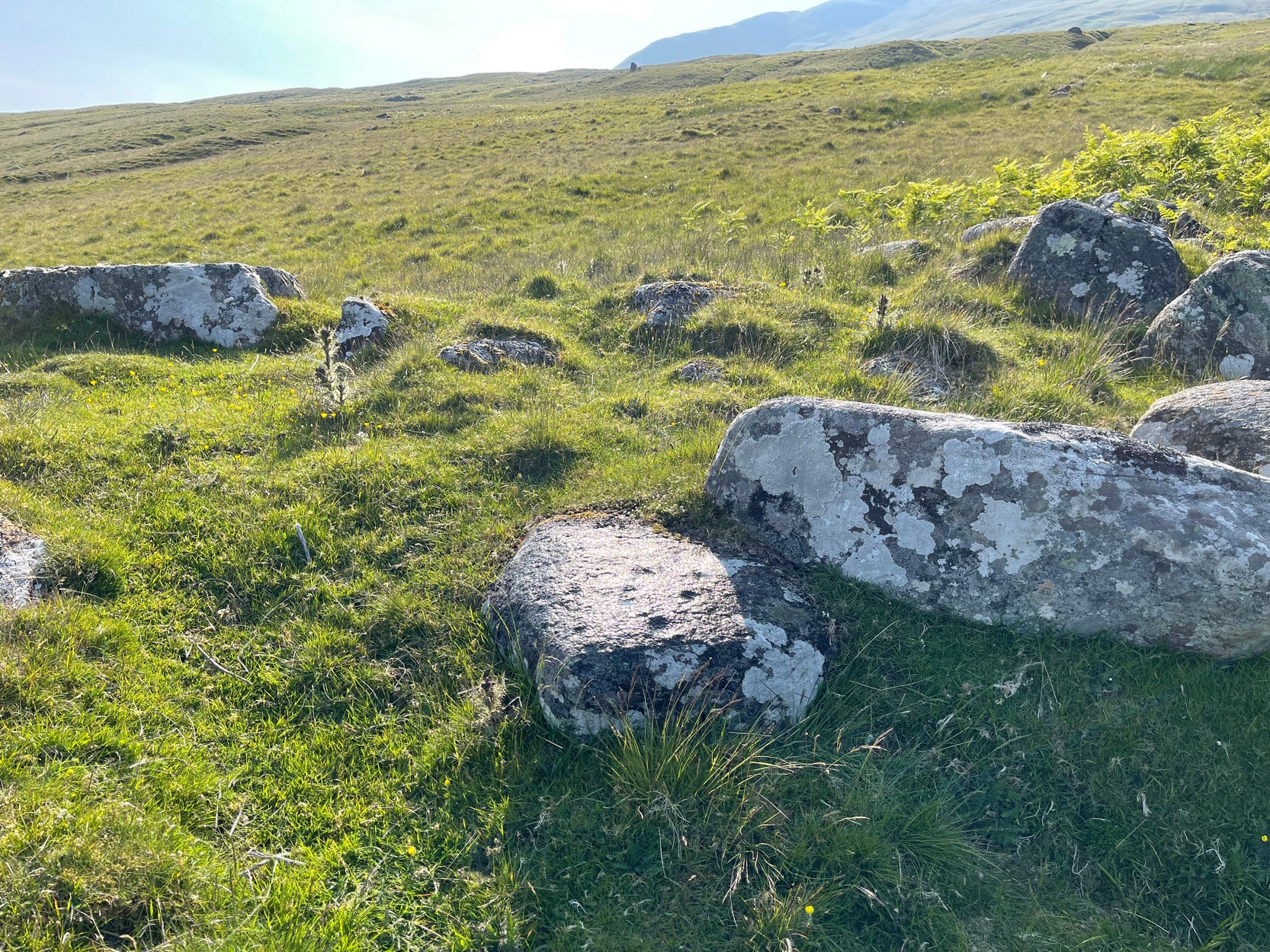
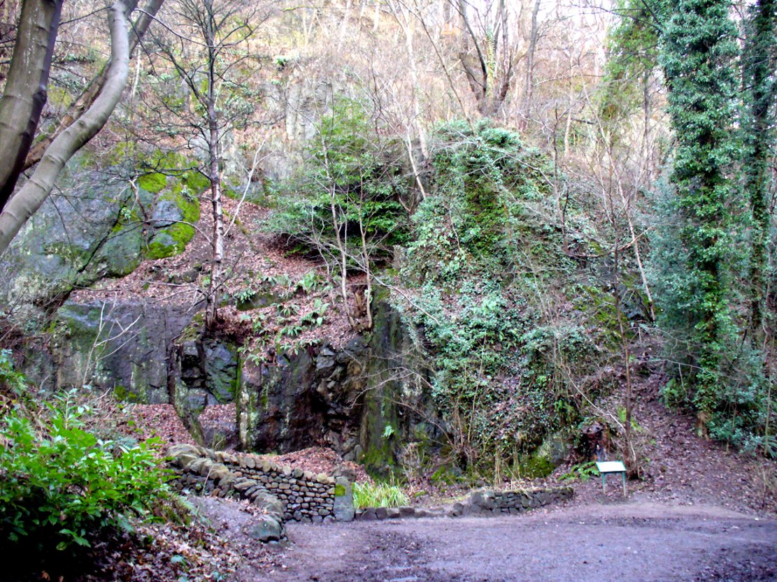
Along the A827 Loch Tay road, halfway between Fearnan and Lawers just beyond the forestry, a track goes up into the fields across from Feadan house (big shed above you in field). Careful, or you’ll miss it. Go up here and head all the way up the steep winding track for 700 yards (as the crow flies) until, where the land starts levelling out, you hit the long straight line of old walling. Go over it and walk to your right (northeast) for a few hundred yards until it bears sharp left (NW), keep walking along it for another 45 yards and, where the fence turns down to the water, just keeping walking up the slope to the scatter of rocks. Look around!
Archaeology & History
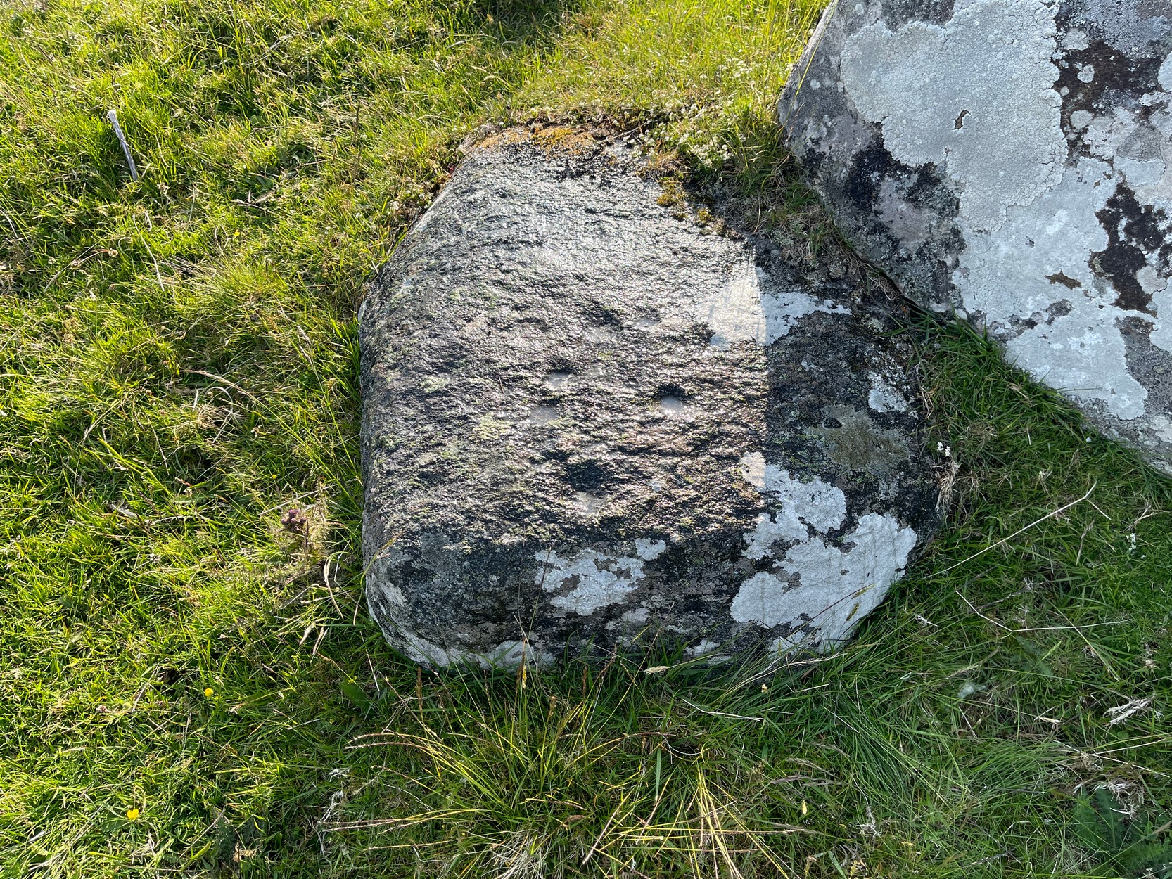
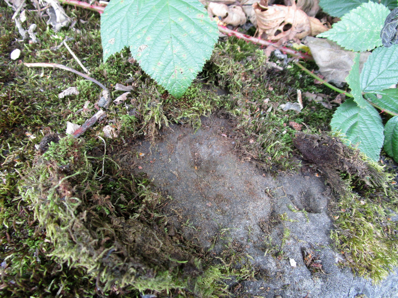
Looking down at the cups
When you consider there are multiple-ringed carvings close by on the same geological ridge as this carving, there’s little wonder this fella hardly gets any attention: the design here is nothing special compared to its close neighbours. That aside: on this small flat surface we have six or seven simple cup-marks; most of them quite small, with the largest of the lot having what looks like a small carved arc around one side of it—although I couldn’t make my mind up one way or the other to be honest. A few more visits might prove more conclusive.
Folklore
The stream at the side of this carving and others nearby—the Allt Coire Phadairlidh, or Padderlie’s Burn—was the haunt of an urisk, who gave his name to the waters. He lived a little further up on the knoll. Several other carvings are just below here. Urisks were plentiful in this area. They are variously described as demonic creatures, referred to by Alexander Carmichael as “a monster, half human half goat, with abnormally long hair, long teeth and long claws.” (teeth aside, that sounds like me! 🙂 ) They mainly live by lonely waterfalls and a small beautiful fall is very close by. They are associated in some places with cup-marked stones, where offerings of milk were made to placate them. In truth, these nature spirits seem to be folk remnants of solitary shaman figures cast into the edges of hills. A local lady who lived in this area said she’d met an urisk near here and he was anything but the fearful creatures they are made out to be…
References:
Currie, George, “Kenmore: Allt Coire Phadairlaidh (AP1): Cup-Marked Rock,” in Discovery & Excavtion Scotland, vol. 9 (new series), 2008.
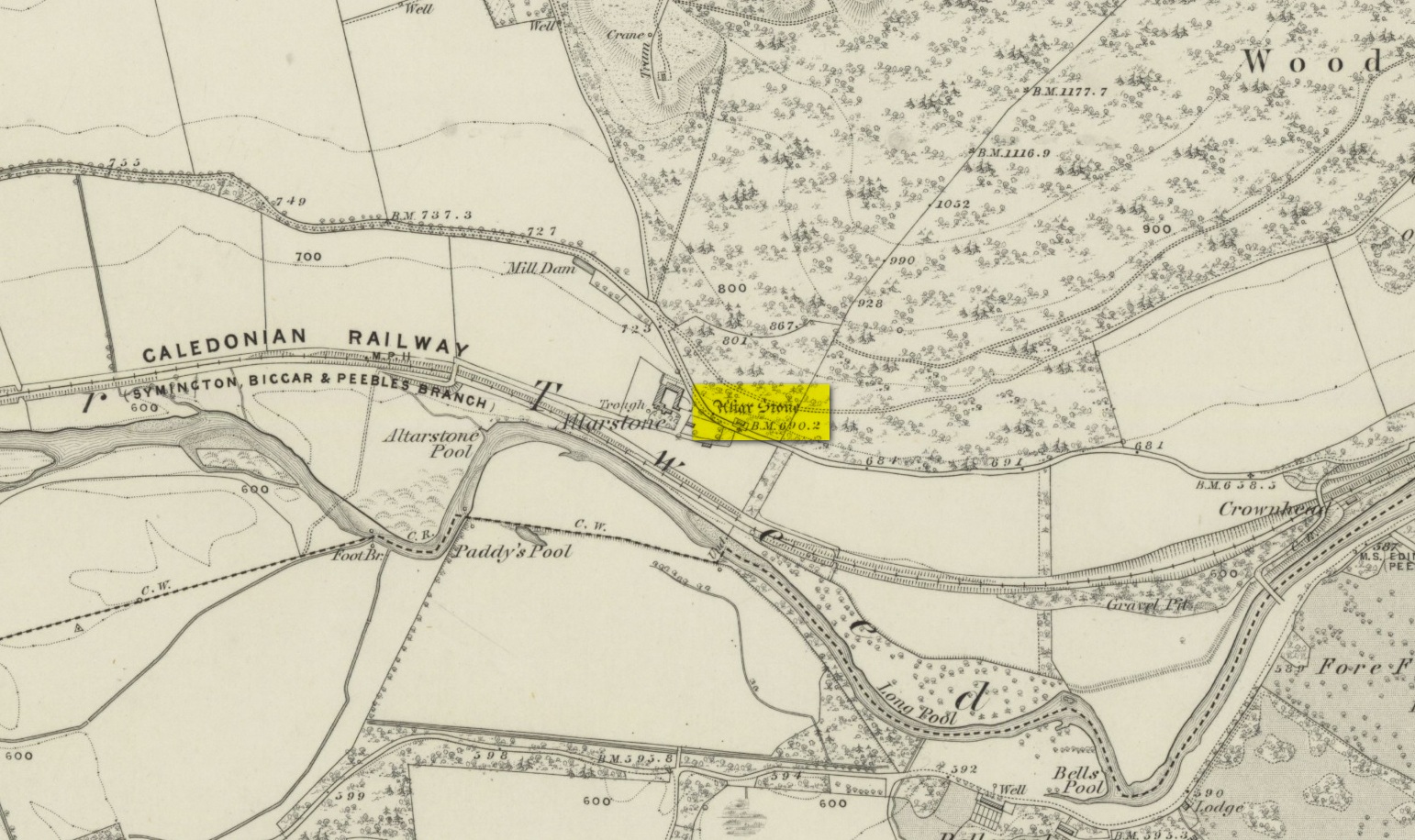
Various ways to get here. From Peebles take the A72 road west to Kirkurd, but after 4 miles turn left onto B712. Several miles down, go past Stobo village and before crossing the bridge over the River Tweed, turn left up minor road leading to Dreva and Broughton. The track into Altarstone Farm is about a mile along and the stone is across the road from there. The other way is going south along the A701 from Broughton village, where you take the left turn towards Stobo. Go along here for just over 3 miles where you reach the woodland (park here where the small track goes into the woods). A coupla hundred yards further along is Altar Stone Farm on your right and the stone is above the verge on your left.
Archaeology & History
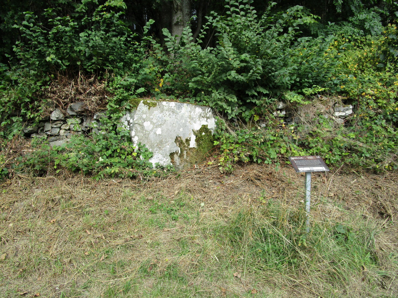
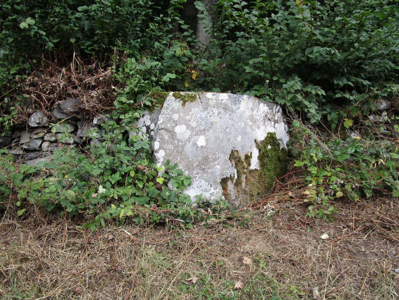
Altar Stone, Stobo
Archaeologically speaking, there’s nowt much to say about this site apart from the usual tedium of its measurements and the rock-type. I’ll give the latter a miss, but the stone stands at nearly five feet high and nearly as broad; with its upper face relatively smooth and the top of it pretty flat. A section from the top of this stone was cut and sliced off a few centuries ago and this was said to have been taken to Stobo church a few miles away, where it was fashioned into a stone font for baptisms. If this is true, then it’s possible that this was once an authentic prehistoric standing stone, but we’ll probably never know for certain. Also on top of the stone you can see a number of geophysical scratches, one of which looks as if it may have been worked by human hands and which has some relevance to the folklore of the stone.
It is shown on the 1859 OS-map of the area and was mentioned in the Ordnance Name Book where they told how it was “supposed to have formed the Altar of a druids Temple or some such object,” but they could find no local verification of such lore at the time of their visit… or at least, no one was telling them anything about it…
Folklore
This fascinating bit of rock—or possible sliced standing stone—is of note due to its association with that old shaman of shamans known as Merlin! Near the end of His days, when He’d truly retired from the world of men and wandered, they say, mad amidst the great lowland forests, an old christian dood by the name of Kentigern—later known as St Mungo—who’d been trying to convert our old magickian away from the animistic ways of Nature, was said to have finally succeeded here, at this very stone. The old Scottish traveller Ratcliffe Barnett (1925) wrote:
“Merlin is the real genius of Drumelzier. Dumelzier means the Ridge of Meldred, a pagan prince of the district. And it was Meldred’s shepherds that slew Merlin the bard. The heathen bard was present at the battle of Arthuret in the year 573, when the christian army gained a victory over the Heathen Host. Merlin fled to the forest of Caledon at Drumelzier and there ever after the old Druid spent his life among the wild hills with a repute for insanity. This poet priest was doubtless heart-broken at the defeat of his pagan friends. The old order was changing. But the christian king had brought his friend, St Kentigern or Munro, to preach the gospel in upper Tweedside at Stobo. One day Kentigern met a weird-looking man and demanded who he was. “Once I was the prophet of Vortigern (Gwendollen). My name is Merlin. Now I am in these solitudes enduring many privations.”
“So Kentigern preached the gospel to the old nature worshipper and won him to Christ. Up yonder, at the east end of the Dreva road, you will find the rude Altar Stone where, it is said, Kentigern received the Druid into the christian church and dispensed the sacrament. But in those dark days of the faith, the Druids and their pagan adherents fought hard against the new religion. So immediately after the admission of Merlin to the Church, the shepherds of Meldred sought him out, stoned him to death on the haugh of Drumelzier, and there, where the Powsail Burn falls quietly into Tweed, Merlin the Martyr was buried. For long his grave was marked by a hawthorn tree.”
These shepherds were said to have stoned him and then threw his body upon a sharp stake and then into the stream. (stone – wood – water)
If there is any hint of truth in this tale, it is unlikely Merlin would have given himself over to the christian ways unless—as any shaman would—he knew of his impending death. In which case it would have done him no harm to pretend a final allegiance to the unnatural spirituality that was growing in the land. But whatever he may have been thinking, it is said that this Altar Stone was where he made such a deed.
Scratch-marks of the mythic hareAltar Stone, Stobo
An equally peculiar legend—variations of which are found at a number of places in the hills of northern England and Scotland—speaks of another shamanic motif, i.e., of humans changing into animals and back. For here, legend tells, an old witch was being chased (by whom, we know not) across the land. She’d turned herself into the form of a hare and, as she crossed over the Altar Stone, her claws dug so deeply into the rock that they left deep scars that can still be seen to this day. From here, the hare scampered at speed downhill until reaching the River Tweed at the bottom, whereupon transforming itself back into the form of the witch, who promptly fled into the hills above on the far side of the river.
One final thing mentioned by Barnett (1943) was the potential oracular property of the Altar Stone:
“You have to only place your hand on top of this rude altar, shut your eyes, and if you have the gift you will see visions.”
References:
Ardrey, Adam, Finding Merlin, Mainstream 2012.
Barnett, Ratcliffe, Border By-Ways and Lothian Lore, John Grant: Edinburgh 1925.
Buchan, J.W. & Paton, H., A History of Peeblesshire – volume 3, Glasgow 1927.
Crichton, Robin, On the Trail of Merlin in a Dark Age, R. Crichton 2017.
Glennie, John Stuart, Arthurian Localities, Edmonston & Douglas: Edinburgh 1869.
Moffat, Alistair, Arthur and the Lost Kingdoms, Phoenix: London 1999.
Rich, Deike & Begg, Ean, On the Trail of Merlin, Aquarian: London 1991.
Wheatley, Henry B., Merlin, or, The Early History of King Arthur – 2 volumes, Trubner: London 1865.
Acknowledgements: Big thanks for use of the 1st edition OS-map in this site profile, Reproduced with the kind permission of the National Library of Scotland.
This was an astonishing-sounding place, little-known beyond the pages of specialist historians. It has been described in modern terms as simply “subterranean structures”, “weems”, or “prehistoric underground houses”; but were this site still in evidence it would be a huge attraction! From the literary descriptions we possess, the extensive remains found and destroyed sound very much like the much-visited fogous found throughout Cornwall, or more commonly known as ‘souterrains’ in Scotland—although there’s no mention of the place in Wainwright’s (1963) singular study on such monuments. Despite this, here, on the south-side of modern Clarkston, it seems we once had a Renfrewshire equivalent to the prehistoric Cornish village and fogous known as Carn Euny.
The first known account of this site was written by James Smith (1845) in the survey for the New Statistical Account, who thankfully gave us a reasonably lengthy account of what was once here. He told:
“About thirty years ago, on the farm of Overlee, which lies on the north bank of the river Cart, in the south-west angle of the parish, Mr Watson, the proprietor, on removing the earth from a quarry which he wished to open, discovered a great many subterraneous houses ranged round the slope of a small swelling hill. Each house consisted of one apartment, from eight to twelve feet square. The sides, which were from four to five feet high, were faced with rough undressed stone, and the floors were neatly paved with thin flag stones which are found in the neighbourhood. In the centre of each floor was a hole scooped out as a fire-place, in which coal-ashes still remained, and seemed to indicate that their occupiers had left the place on a sudden. That coal and not wood or peat had been employed as fuel, seemed at first an argument against the antiquity of the houses, until it was remembered that many seams of coal crop out on the steep banks of the river in the immediate vicinity, which may have been picked out for firing by the aboriginal inhabitants, as is still done to a limited extent by a few of the poorer classes in the neighbourhood. Near the fire-places were found small heaps of water-worn pebbles, from two to three inches in diameter, the use of which it is difficult to conjecture. They may have been used as missiles for attack or defence in the rude warfare of ancient days, or more probably they served the purposes of an equally rude system of cookery, by which meat was prepared for being eaten by heated stones placed round it, as is still done in many of the South Sea islands. The floors of the houses were covered to the depth of about a foot with a rich black vegetable mould, which was in all likelihood the decayed remains of the roofs mixed with soil filtered from the surface. As was gathered from the different appearances of the soil, in and over them, the houses were partly excavated from the hill and partly built above ground, and a level approach to the entrances was dug out of the slope. The number discovered amounted to forty-two, of which thirty-six formed the arc of a lower and larger circle, and the remaining six, also circularly ranged, stood a little higher up the hill. The writer is informed that the ruins of villages of a similar description have been discovered in several parts of Scotland; and there is an account of one very much the same as the above, recorded in the third volume of the Transactions of the Antiquarian Society of Scotland. About twelve querns or small hand-mills were found near the site of these houses, and a grave lined with stone containing a rude urn filled with ashes. These latter relics, however, may have belonged to a still distant but less remote antiquity. The old castle of Lee or Williamwood was erected near the place, and it is not improbable that, in procuring materials for the building from the freestone, of which the hill consists, the soil, which for so many centuries concealed the remains of the village, was thrown down upon it. Several years ago, the proprietor, in clearing away the old foundations of the castle, which interfered with the rectilineal operations of the plough, found within the square which they enclosed many human bones, which he avers were of almost superhuman magnitude.
“If the natives of the village, described above, deserted their homes hastily, as may be conjectured from the fact of the fuel remaining on their hearths, it may have been in terror of the Romans—one division of whose invading army must have passed not far from the place. In a direct north-east line from this hill, without any intervening eminence, and at the distance of about two miles, there are still very distinct traces of a small Roman encampment on the summit of a hill, the name of which, from the circumstance, is Camp Hill…”
Although the modern official description of these remains is simply that of “a settlement”, the idea that some of the remains here were souterrains seems beyond doubt. The comparison James Smith makes with remains that were found shortly afterwards that were “very much the same”, unearthed at Cairnconon—or the West Grange of Conon, as Canmore call it—northwest of Arbroath, confirms this idea.
Just over a decade after Mr Smith’s initial account, the Glaswegian historian James Pagan (1856), in his huge History of Glasgow, included another description of the place from the pseudonymous 19th century writer “J.B.” In what were called Desultory Sketches, much of what he wrote merely echoed the original notes by Smith, but they are still worth repeating:
“Specimens of the winter houses, or weems, were to be seen, till recently, in our own district, at Cartland Craigs, near Stonebyres, on the Clyde; and one very interesting example of the pit-houses was revealed in 1808, on the farm of Overlee, near Busby, in the vicinity of Glasgow. The following particulars regarding these were communicated to the writer of this sketch, by the parish minister of Cathcart, who had his information from an eye-witness.
“While the farmer was removing soil to get at freestone, for building a new steading, he came on a cluster of subterranean aboriginal huts. They were forty in number, and ranged round the face of the hill on which the farm-house of Overlee now stands. These huts were of the most primitive kind. They were mere semicircular pits, cut out of the hillside, with a passage to the door, also dug out of the slope, on a level with the floor, as indicated by the different colour of the soil. Each consisted of one small apartment, about twelve feet square, five feet high, and faced with stone. The floors were neatly paved with thin flag-stones, found in the neighbourhood. In the centre of each was a hole for a fireplace, in which ashes were still visible. Near the fireplace were small piles of water-worn stones, two or three inches in diameter, probably for cooking food, by placing heated stones round it, as is yet done by some of the islanders in the Pacific Twelve hand-querns of stone for grinding grain were found in the houses. At a short distance, a grave was discovered, lined with stone, and containing rude urns filled with ashes, thus indicating that the inhabitants of this primitive cluster, near what is now Glasgow, burned their dead. Unfortunately, the whole of these curious pit-houses were ruthlessly destroyed.
“In some of the weems and pit-houses, small groups of pretty oyster-shells have been found, perforated with small holes, as if they had been strung together, and formed an ornamental necklace—shall we say for the lady-savage of that distant epoch? In others were discovered bodkins and skewers, made of horn, probably to hold together the folds of the wild beasts’ skins forming the savages’ winter covering; the bones of oxen, neatly notched, as if for ornament; bowls made of stone, the hollow having been drilled out by the circular action of another stone, sharper and harder, aided by the grit of sand (one of which is now before me); arrow-heads and lances formed of flint or bone, some of the former of which I happen to possess; —nay, swords have been found, fashioned from the bone of a large fish! Heavy oaken war-clubs, too, must not be omitted from this curious catalogue.”
Although highly unlikely, there is the remote possibility that some remains of these underground ‘houses’, or souterrains, could possibly still be unearthed hereby. In recent years we’ve encountered a number of good farmers and land-owners who’ve told us about souterrains beneath their fields that are not in any record-books. Intriguingly, each one asked us, “who are you working for?” – and when we’ve assured them that we have nothing to do with the ‘official’ bodies, they’ve opened up and showed us. In one instance, a land-owner in Angus told us how he was farming the field as he’d always done, “when my tractor fell into a huge hole in the ground – and there was another souterrain!”
Why am I telling you this? Well, if you’re a local, maybe get round to Overlee and ask around some of the olde local people. You never know what you might find! And we could perhaps try find more about the other souterrain which the pseudonymous ‘J.B.’ said was “at Cartland Craigs, near Stonebyres, on the Clyde.”
References:
McBeath, H.D., Walks by Busby and Thorntonhall, with Historical Notes on the Area, EKDC: East Kilbride 1980.
Cup-Marked Stone (destroyed): OS Grid Reference – NX 0010 5411
Archaeology & History
Very little is known about this long-lost carving, whose primary information comes from the folklore records. Apparently it was found on a rock a short distance south of the destroyed St. Patrick’s Well and the two sites seem to have had a traditional relationship with each other. The carving had a foot-shaped motif on the rock, and a number of other cup-markings; but I can find no account as to whether the ‘foot’ carving possessed ‘toes’, as seen on the impressive Cochno Stone, north of Glasgow. It may have been little more that the petroglyphic ‘feet’ seen on the recently discovered and aptly-named Footprint Stone, or those on the newly rediscovered Witches Stone; but we cannot discount it being larger, like the Footprint Stone of Dunadd. If we could locate an early sketch of the stone, all would be revealed! Sadly, as E.M.H. M’Kerlie (1916) told us,
“this rock was blasted at the time when the government essayed to make the harbour one of great importance”,
several years after the nearby holy well had been re-routed. Fucking idiots! Any further info on this site would be most welcome.
Folklore
The local story that was told about St. Patrick creating these carvings seems to have been described first of all by Andrew Agnew (1864), who wrote:
“Once, when about to revisit his native land, he crossed the Channel at a stride, leaving the mark of his foot distinctly impressed on one of the rocks of the harbour; unfortunately, in making a new jetty, this interesting memento was destroyed.”
(The mention of the jetty would seem to imply that the carving was closer to the sea than the grid-reference cited above.) In another tale, St. Patrick rested his hand onto the same rock and the marks of his hand and fingers were left there. This folklore motif is found across the world. It relates to cosmological creation myths of indigenous spirits and deities in the tribes and cultures who narrate it. In this instance, the myth of St Patrick replaced a much earlier mythic tale of another giant or deity, whose name we have lost. Unless, of course, such petroglyphs were still being carved in Galloway by local people in the 4th-5th centuries.
A further tale of St Patrick, at Portpatrick, replaced a quite obvious shamanistic tale. When he journeyed back from Ireland to Galloway, Agnew again told us:
“Having preached to an assembly on the borders of Ayrshire, the barbarous people seized him, and, amidst shouts of savage glee, struck his head from his body in Glenapp. The good man submitted meekly to the operation; but no sooner was it over than he picked up his own head, and, passing through the crowd, walked back to Portpatrick, but finding no boat ready to sail he boldly breasted the waves and swam across to the opposite shore, where he safely arrived (according to the unanimous testimony of Irishmen innumerable), holding his head between his teeth!”
Legends such this are found in shamanistic pantheons worldwide. Shamans primary renown is their ability to travel and recover from the Lands of the Dead, always journeying into impossible and inhospitable arenas, with tales of being dismembered, beheaded, dying, and returning to life to help the tribe with whatever it was that required such a task (usually a healing function). This story of St Patrick – and many other saints – are mere glosses onto the earlier animistic stories, then abridged as being better, more spiritually mature, more egocentric. But their roots are essentially animistic.
Royal Commission Ancient & Historical Monuments of Scotland,Inventory of Monuments and Constructions in Galloway – County of Wigtown, HMSO: Edinburgh 1912.
Walker, J. Russel, “‘Holy Wells’ in Scotland,” in Proceedings of the Society of Antiquaries of Scotland, vol.17 (New Series, volume 5), 1883.
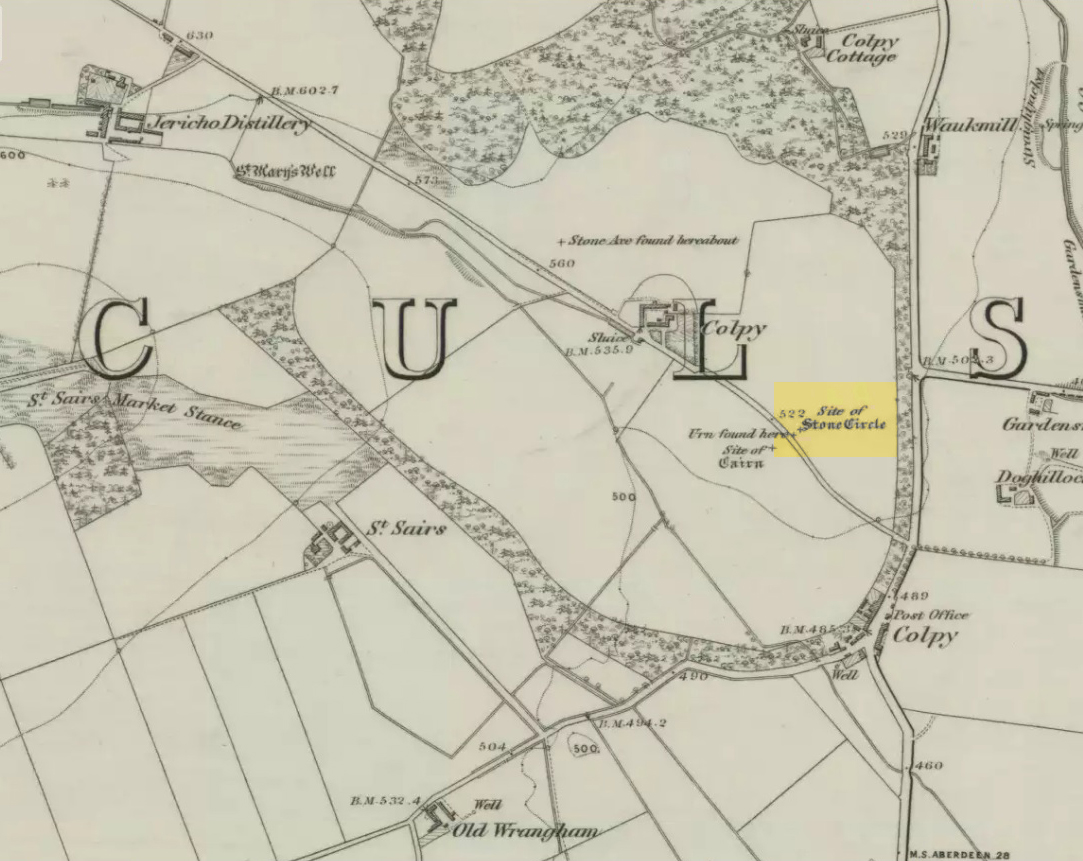
Just like the stone circle a half-mile east at Kirkton of Culsalmond, nothing now remains of this megalithic ring. It was first described very briefly by Rev. F. Ellis (1845) in the New Statistical Account as a “druidical temple”: one of two hereby, “on the farm of Colpie, although now almost obliterated. Several urns were dug up in making a road near one of them”—implying that one of them was a cairn circle or funerary monument of some kind. This was subsequently affirmed on the early OS-map and then described in Fred Coles’ (1902) survey, where he wrote:
“Site of a stone circle, the road going to Jericho Distillery having been made through it, and, on the south side of this road, the site of a cairn. Within the possible diameter of the circle an urn was found.”
Folklore
A few hundred yards west of the circle an ancient fair used to be held, known as St Sair’s Fair, named after St Serf. Although St Serf’s Day is July 1, early records show that the fair—held in a long field with the curious name of ‘St Sairs Market Stance’—was to be held on the Wednesday after the last Tuesday in June. For a stone circle, this is too close to Midsummer to be a coincidence! Early records show that the fair was granted in 1591 and subsequent years thereafter.
St Serf is a very peculiar mythological figure with quite shamanistic traits and tales around him. In truth, many of these early saints were little more than lapsed shamans, utilising natural magick and medicine in the olde traditions, but which became grafted onto the incoming christian mythos. The evidence for this is quite overwhelming!
References:
Barnatt, John, Stone Circles of Britain – volume 2, BAR: Oxford 1989.
Browne, G.F., On Some Antiquities in the Neighbourhood of Dunecht House, Aberdeenshire, Cambridge University Press 1921.
Burl, Aubrey, “The Recumbent Stone Circles of North-East Scotland”, in Proceedings Society of Antiquaries, Scotland, volume 102, 1973.
Burl, Aubrey, The Stone Circles of the British Isles, Yale University Press 1976.
Burl, Aubrey, The Stone Circles of Britain, Ireland and Brittany, Yale University Press 2000.
Take the same directions to reach the giant Carn Ban prehistoric tomb. Follow the track past the tomb further onto the moorland until you reach a small wooden bridge over the small burn. From here, walk straight north off-path onto the moor for 100 yards and a small rise in the land, with several cairns just below it, is the site in question.
Archaeology & History
Hut circle are hut circles – right? Well, usually that’s the case. We find them attached to, or within, or outlying prehistoric enclosures and can date from anywhere between the neolithic and Iron Age periods. With the site we’re looking at here, on the outer western side of Glen Cochill’s southernmost giant enclosure, there’s something amiss….or maybe that should be, “something rather peculiar.”
Mr Hornby, hut-sideShamans Lodge walling
Paul Hornby found it a few weeks ago during an exploration of the region’s prehistory. We went in search of, and found, the giant Carn Ban close by, but noticed curious archaeological undulations ebbing in and out of the heathlands: cairns, walls, hut circles, settlements, more cairns—and then this!
Consisting of two slightly larger-than-average ovals of walled stone, probably Bronze Age in date, the first impression was of a remarkably well-preserved site (and that it is!), seemingly of an elongated stretch of walling, with a central wall that split it into two halves. Each ‘hut circle’ was found to be between six and seven yards across, with the two conjoined architectural features giving an overall NW-SE length of 14 yards. But the more we looked at this, the more obvious it became that this was originally one single hut circle—the lower southeastern one—with an additional one that was added and attached onto the northwestern side at a later date, probably several centuries later.
Lower earlier hut circle, with upper later hut circle attached
Walking around the structure we found that the very well-preserved walls—about 2 feet wide in places and rising a foot or so above the compacted peat—had been built onto a raised platform of earth. This was no ordinary hut circle! The ground beneath it seems to have been raised and supported and on the southern side in particular it is notable that other building stones are compacted into the peat. There may even be the remains of a secondary outer wall on this southern edge, where it seems that the entrance was made.
Small group of cairns 15 yards away
Here’s the curious bit: immediately outside the northwestern and southern walls are small prehistoric tombs, or cairns. Not just one or two, but more than a dozen of them, all constructed within 20 yards of this curiously raised double hut circle. Literally, a small prehistoric house of some form was raised in the centre of a prehistoric graveyard—and it doesn’t end here.
Of at least three giant enclosures in this region, and what looks like a very well-preserved prehistoric tribal hall or meeting place, there are upwards of a hundred tombs scattered nearby. Two cairn circles were also found about 100 yards to the north, one of which was damaged by a military road a few centuries ago.
Close-up of walling
I give this double-roomed abode the somewhat provocative title of the Shaman’s Lodge because of its setting: surrounded by tombs, the ‘house’ would seem to have been a deliberate setting erected in the Land of the Dead here. I hope you can forgive my imaginative mind seeing this as a structure where, perhaps, a medicine woman would give rites to the dead, either for those being buried in the small graves, or rites relating to the giant White Cairn of the ancestors close by. Shamans of one form or another occur in every culture on Earth and have been traced throughout all early cultures. If no such individuals ever existed within the British Isles, someone needs to paint one helluva good reason as to why they believe such a thing….
When the heather grows back here, the site will disappear again beneath the vegetation. It is unlikely to re-appear for quite sometime, so I recommend that anyone wanting to have a look at this does so pretty quick before our Earth covers it once again….
References:
Stewart, Margaret E.C., “Strath Tay in the Second Millenium BC – A Field Survey”, in Proceedings Society Antiquaries Scotland, volume 92, 1961
Acknowledgements: Huge thanks again to Paul Hornby for his assistance with site inspection, and additional use of his photos.
From the main street through Alva, between the Co-op and the corner shop, go up the small road at the side of the Johnstone Arms Hotel (Brook Street) and, at the small crossroads, straight across as if following the sign to the golf course. Stay along the track parallel with the Alva Burn waters and as you go into the trees a hundred yards or so along, to your left is a disused quarry, with a couple of plaques telling you its brief history. This is the spot!
Archaeology & History
This is a truly fascinating site for a number of reasons. Sadly, we can no longer see what had been here for oh so many thousands of years thanks, as usual, to the industrialists destroying the land here. Although in this case, without them we’d be unaware of its very existence. Additionally, there is a twist to the industrial’s find, which seems to have stopped further quarrying by some local people….
The tomb was somewhere in the left-middle
Listed in the relative Royal Commission accounts (1933; 1978), without comments, the tale is a simple one, but was narrated in some detail by J.G. Callander (1914) in Scotland’s prodigious Society of Antiquaries journal. During some quarrying operations over the Christmas period of 1912, James Murdoch “uncovered the remains of a human skeleton which had been buried in a natural cavity in the rock.” Three weeks later, local police officer George Donald and Dr W.L. Cunningham of Alva, accompanied Mr Callander to the site and made a detailed assessment of what had been found. He wrote:
“The quarry in which the grave was found is situated at the mouth of Alva Glen, a few yards distant from the right bank of the burn which flows through it. The body had been placed in a cavity or rock shelter in the face of the cliff, about 40 feet from the base, and about 200 feet above sea-level, and a rough, curved wall of dry-stone building, about 1 foot in thickness, had been built across the opening, which faced the east, the ends of the wall being still in situ when I visited the site. The space enclosed measured about 4 feet 6 inches from north to south, and about 5 feet from east to west. Subsequent to the burial the whole face of the rock and the walling had been covered, to a thickness of probably some 6 feet, by soil and detritus washed down from the hill face above. The greater part of the floor of the cavity was formed of clean, broken, angular stones, but the space on which the body was placed had been covered with a thin layer of soil preparatory to the burial. No charcoal or charred wood, which is so often seen in prehistoric graves, was found in this deposit. The skull lay in the north end of the grave, on its right side, facing the rock to the west, the vertebrae and ribs followed a line to the south, and the nether limbs were inclined towards the interior of the cavity. The whole face, including all the teeth and the lower jaw, was a-wanting. Apparently the body had been placed in a flexed position, half on its side and half on its back. Nothing else was found in the grave but a quantity of snail shells, probably twenty or thirty, which were nearly all broken, the few complete examples being in a very fragile condition.
“Elsewhere it has been stated that these formed a necklace, but while they were strewn out in front of the skeleton for a distance of over 3 feet, none of them showed any signs of artificial perforation. The species of Helixis is probably hortensis, the common garden snail.”
Mr Callander then included a lengthy description of the body itself, some of whose bones were fractured. He told that a certain
“Professor Bryce states that the skeleton is that of a dwarf of about 4 feet 2 inches in stature. The epiphyses are all fully united, although the line of union is visible on the surface at some points. Growth must therefore have been completed, and the person must have been, if the union of the epiphyses of the long bones had pursued its normal course, over twenty-one years of age…”
Regarding the sex of the dwarf, Mr Bryce wasn’t 100% certain, but told:
“The calvaria shows the general characters of a female skull, but it cannot be stated definitely that the individual was a woman, because the cranial characters are such as might have been present in a dwarf of the male sex. The calvaria is of moderate size, and is well formed.”
Bryce concluded as a whole that this person was in reasonably good health and, from the condition of the bones, showed “there was no evidence of the disease known as rickets.” In his final remarks he told:
“The general conclusions to which a careful examination of the skeleton leads, is that we have here to do, not with a representative of a dwarfish race, but with an individual who from premature union of the epiphyses was to a remarkable degree stunted in growth. The condition is a well-known one, and the class of dwarfs, in which this individual must be included, is well recognised.”
Probable spot of the lost tomb
The exact spot of the tomb appears to have been destroyed, or at the very least is certainly covered over and no longer visible. The section of the quarry looking east, into which the tomb was built, is all-but gone and no initial evidence prevails to show its exact location. However, it would seem from the description to have been close to the tops of the tree-line, perhaps giving a clear view to the rising sun in the east. Perhaps…
The position of this tomb, enclosed high up in the cliffs, hidden away at the entrance to the deeply cut ravine of the Alva Glen, is intriguing in that it is a rarity. Ravines like this are always peopled by olde spirits in animistic tribal traditions — and this dangerous glen with its fast waters and high falls would have been no different, especially to the Pictish people who we know were still here even after the Romans had buggered off. Is it possible that this figure was a guardian to the Glen itself, a medicine woman or shaman, whose very Glen was her home? We know from traditional accounts in many of the North American tribes that dwarves were accessories to the spirit worlds, and some were shamans. (Park 1938) In northern and central European lore, these small people are “the mysterious craftsmen-priests of early civilizations.” (Motz 1987) Whilst in Scottish lowland lore, the ‘Brown Man of the Muirs’ was a dwarfish creature described by Briggs (1979) as “a guardian spirit of wild beasts”, or watered-down shaman figure. There is more to this burial than meets the eye of dry academia…
Folklore
The Alva Glen—in addition to being beautiful and home to the Ladies Well—was long known to be one of many places in the Ochils that were peopled by the faerie folk. (Fergusson 1912) Local people still say this place is haunted by the spirit of a dangerous witch called Jenny Mutton.
It’s worth reiterating the words of Mr Callander (1914) regarding the finding and subsequent death of the man who uncovered this fascinating tomb, as some folk (then as now) think his demise was as inevitable as the man who planned on building turbines in Glen Cailleach:
“On the 24th December last, while quarrying stone for road metal in a quarry at the foot of the Ochils, at Alva, James Murdoch uncovered the remains of a human skeleton which had been buried in a natural cavity in the rock. Two days later he was killed at the same spot by the fall of a mass of overhanging rock, a tragic sequel, which not long ago would have been considered a judgement on him for disturbing the dead.”
References:
Briggs, Katherine M., A Dictionary of Fairies, Penguin: Harmondsworth 1979.
Corbett, L., et al., The Ochil Hills, Forth Naturalist & Historian 1994.
Drummond, A.L., “The Prehistory and Prehistoric Remains of the Hillfoots and Neighbouring District”, in Transactions Stirling Natural History & Antiquarian Society, volume 59, 1937.
Fergusson, R. Menzies, The Ochil Fairy Tales, David Nutt: London 1912.
Gimbutas, Marija, “Slavic Religion,” in Encyclopedia of Religion – volume 13 (editor M. Eliade), MacMillan: New York 1987.
Motz, Lotte, “Dvergar,” in Encyclopedia of Religion – volume 4 (editor M. Eliade), MacMillan: New York 1987.
Park, Willard Z., Shamanism in Western North America: A Study in Cultural Relationships, Evanston: Chicago 1938.
Royal Commission on the Ancient & Historical Monuments, Scotland, Inventory of Monuments and Constructions in the Counties of Fife, Kinross and Clackmannan, HMSO: Edinburgh 1933.
Royal Commission on the Ancient & Historical Monuments, Scotland, The Archaeological Sites and Monuments of Clackmannan District and Falkirk District, Society of Antiquaries of Scotland 1978.
Carlie Craig is the tree- covered cliff, centre of photo
If you’re coming from Blairlogie, a half-mile west of the village, take the B998 road to the university, but turn right up the first road that runs uphill into the trees. But if you’re coming from Stirling or Bridge of Allan, keep your eyes peeled for the barely visible B998 at the crossroads and go up the hill, and along, for a good mile, below the Uni, past the factory, then up the small road on your left. Up this road go past the church another 100 yards and you’ll see the derelict ruins of Logie Kirk on your right. Right above the ruin you’ll see the tree-lined cliff immediately behind. This is the Carlie Craig!
Folklore
Carlie Craig on the 1862 map
The tree-covered Carlie Crags above the old ruined church and graveyard of Logie Kirk immediately below (thought to have been built in 1684) has long been associated with legends of old witches. Deriving its name from ‘carlin’, a witch or old woman (cailleach), the Crags were traditionally the place of heathen rites (authentic ones, not your plastic pagan types). In David Morris’ (1935) essay on the local township, he told the common story that “an elder in Logie Kirk was of the opinion that the Carla’ Craig…was haunted.” At the end of the 19th century, Morris remembered a local lady known as ‘Ailie’, who was said by many old folk to be the traditional “witch of Logie.”
“Sickly children were brought to her for her blessing. Occasionally people came from as far as Stirling on this errand. Her method of giving the blessing was to blow her breath on the child, and this was supposed to ward off evil. It was also said that anyone buried in Logie Kirkyard on the first day of May, Hallowe’en, or other days of that kind, without her blessing, would not rest in his grave…”
Another legend told that,
“around 1720 witches were believed to rendezvous with the Evil One (i.e. the devil) who would appear in the form of a large black dog.”
A lengthier account of the belief in witchcraft and animistic pre-christian rites above the crags was told by Charles Rogers (1853):
“About the second decade of last century, there lived in the parish of Logie several ill-favoured old women, to whom the reputation of witchcraft was confidently attached. They were believed to hold nocturnal dialogues and midnight revels with the Evil One, and Carlie Crag was regarded as one of their places of rendezvous. Satan, though he was believed to appear to them in various forms, was understood, in his interviews with the dreaded sisterhood, to appear most frequently in the aspect of a large shaggy dog, in which form it was alleged he had repeatedly been seen by the minister. An elder of the kirk had been returning of an evening from a shooting excursion among the hills, with a trusty musket, which he had picked up some years before on the field of Sheriffmuir, and discovering on the top of Carlie an animal realizing the description of the Satanic mastiff, resolved to try upon it the effects of a shot. He knelt down cautiously near the foot of the crag, and after ejaculating a short prayer, and slipping into his musket a silver coin, fired with trembling heart but steady aim. His victim, evidently shot dead, tumbled to the base, and the delighted and astonished elder lost no time in personally communicating to the minister the success of his wonderful adventure. Though not a little superstitious, the minister was somewhat sceptical as to the mysterious dog being really dead. He however agreed to accompany his elder next morning to the foot of the crag to inspect the carcase; but on reaching the spot, they found the remains of no shaggy dog or evil genius, but the lifeless form of the beautiful pet goat of a poor and aged woman, a much respected parishioner. The minister and elder both shed tears. The wicked dog still lived, the innocent goat had perished. The elder however took credit to himself for his good intentions and valorous intrepidity ; and the minister deemed it proper to improve the subject in his pulpit prelections on the following Sabbath. Discoursing on the subject of resistance to the Devil, he remarked, that the Evil One might assume numerous shapes and forms; that he went about as a roaring lion was declared in the Word, but he might take to himself various other aspects. He might even appear as a black colley dog.” But whatever form he may assume,” added the minister, ” he cannot be overcome or destroyed by powder and shot. There is a gun, however, that will shoot him, and it is this — it is the Bible. Shoot him then, every one of you, with this gun, and he shall be shot.”
Whether the vicar’s biblical superstitions were adopted by local people—who were so much more used to the living animism of landscape and natural cycles—is questionable. The crag is a fine site for ritual magick and its associative devil-lore probably derives from Pictish shamanistic practices, remains of which are evident across the Scottish hillls and northern England, where they survived for some considerable time…
References:
Morris, David, B., “Causewayhead a Hundred Years Ago”, in Transactions of the Stirling Natural History and Archaeological Society, 1935.
Roger, Charles, A Week at Bridge of Allan, Adam & Charles Black: Edinburgh 1853.
Watson, Angus, The Ochils – Placenames, History, Tradition, Perth & Kinross District Libraries 1995.
Follow the same directions to get to the cup-marked stone on the slope behind Duncroisk Farm. Once here, look up the hillside and about 100 yards above you there’s the fence, and a gate in the fence. Go through that gate and walk uphill for some 20 yards where you’ll meet with a large sheet of flat sloping rock with a stream by its side. The crosses are on this rock sheet at the top left-hand side.
Archaeology & History
Although the stone here is pretty easy to find, the insignia carved on the rock itself can be troublesome to see. The accounts by both Cormack (1952) and Morris (1981) each recommend visiting the site around sunrise, but an hour before sunset is also profitable if you wanna see the design with any clarity. And of course, if you keep the rock-face wet (the adjacent stream is handy here) the carvings stand out even better!
Main section of carvingSolar cross & arrow?
It’s a quite superb carving in a truly superb setting, come rain, shine or mist — but for the cup-and-ring aficionado’s amongst you this one might not get y’ going, as we’re looking at a carving that was probably born of the more recent mythic period. Although there are between two and four faded cup-markings here, the principal designs do not echo the more usual neolithic and Bronze Age carvings scattering this part of Perthshire. Instead we find very worn examples of what have been variously called “solar wheels”, “Greek crosses”, Celtic crosses, etc. We also find simple carved ‘arrows’ at the ends of both natural and man-made lines in the rock; along with very distinct ‘eye’ or vulva symbolism. (Crawford 1957) Added to this is the possibility of human figurines discernible in the carving, very similar indeed to those found in Spain (Kuhn 1956) and elsewhere.
The site was first described by E.A. Cormack (1952) who wrote the following, (slightly edited) piece:
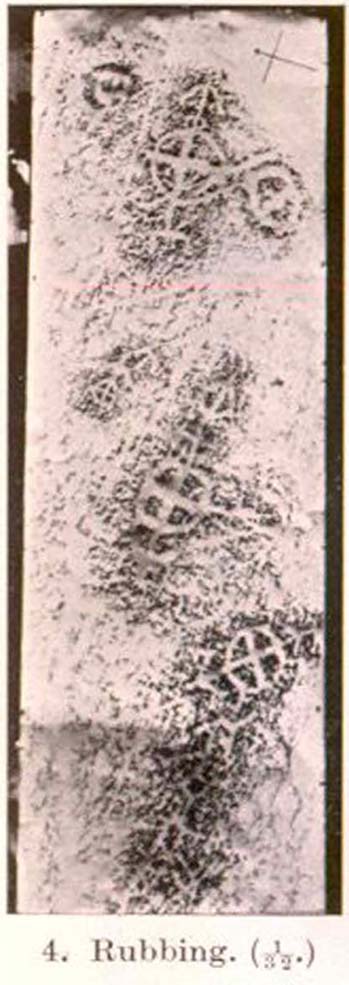
“Examination of the rough and sloping rock surface revealed an interesting group of inscribed figures, confined to an area of about 8 by 2½ feet, four of which included a cross within a circle. The figures are difficult to discern, except when thrown into relief by early morning sunlight, but are clearly demonstrated on a rubbing.
Cormack’s 1952 rubbing of the carving
“The crosses may be described in three groups:
“Group 1 — a) Near the upper edge of the rock is a cross within a circle of 8-inch diameter. The vertical axis of the cross is extended below the circle for 4 inches, resting on an ill-defined rectangular base, and upwards for 5 inches to form an arrow-head with 3-inch barbs. At the junction of the shaft of the arrow with the top of the circle is a pair of contiguous rings of about 1-inch diameter. The cross is deeply cut, to about a half-inch depth, with equal arms 4 inches long and 1 inch broad. The left arm of the cross extends beyond the circle, but this may be due to the circle being slightly excentric in relation to the cross. The lower right quadrant of the circle is marred by a natural crevice in the rock, but careful examination shows that the circle does not cut the right arm of the cross.
b) On each side of this figure is a roughly circular marking, one about 4 inches above and to the left, of 3-inch diameter, and the other 2 inches to the right, of about 5-inch diameter. In each there is an indefinite depression across the centre.
“Group 2 — a) About a foot below and to the right of Group 1 there is a boldly cut cross within a 7-inch circle. Again the vertical arm of the cross is extended above and below the circle, downwards for 5 inches to a curved arrow-head with 4-inch barbs, and upwards as an equal armed 5-inch crosslet above which is a 4-inch circle with the central axis continued through it. (The junction of this axis through the circle with the top of the small cross is slightly angled.) The main cross and circle are cut to fully half an inch in depth and one inch in breadth, but the upper part of the figure is much less distinct.
b) About 8 inches to the left of the upper part of the above figure is a very faintly incised cross within a 2½-inch circle. It is difficult to discern on the rock, but can be seen in the photograph and is very clear on the rubbing. It also appears to have an arrow-head above it.
“Group 3 — a) A foot below and to the right of Group 2 is a clearly cut cross within a 6½-inch circle. A natural cleft in the rock has been used for one axis of the cross, which lies obliquely to the others already described, and this axis terminates in an arrow-head 3 inches below the circle, and another slightly smaller arrow-head is cut 2 inches above the circle; in each case the angle formed by the arrow being towards the circle.
b) Immediately below the last cross is a curious hieroglyph not easy to make out on the rubbing, but clear in the photograph. On an 18-inch vertical axis can be seen from above downwards an arrow-head, an oblique line to the left, a faint 2-inch circle, a transverse stroke, and finally two oblique lines to the right. A natural crevice to the left of the figure rather confuses the picture.”
Ron Morris’ (1981) description wasn’t as detailed and he was initially hesitant about using the site in his rock art survey of the area, as he thought it “most likely to be early christian” in nature and period. He changed his view after talking with an associate at Bergen University, who pointed out that the symbols found here up Glen Lochay were “exactly the same as Norway’s second commonest symbol, the ‘Cross-ring’, which is contemporary with their cup-and-ring series.” Morris described the carvings here as:
“3 ‘cross-rings’ and 7 other rings, some of which have traces of crosses within them. There are also grooves, some extending from a ‘cross’-line to form an ‘arrowhead’, and one group, with ring above, rather resembles a ‘man.’ Largest ring diameter, 20cm (8in) and greatest carving depth, 1cm (½in).”
Examples of the artistic symbolism found at this ‘Duncroisk Crosses Stone’ are scattered throughout western Europe from the Bronze Age period onwards: notably at Dowth and Clonfinloch in Ireland (Brennan 1983; Coffey 1912); Jonathan’s Cave, Fife (Simpson 1867); Valcamonica, Italy (Anati 1961); and all over Norway and Sweden (Coles 2005; Gelling & Davidson 1969; Janson 1966). In more recent times we find these curious symbols etched inside the prehistoric chamber of Ty Illtud (Grinsell 1981) — but these are thought to be later additions. However, the universal nature given to such interconnecting symbols such as those found here is, simply, ritual magick. We find it across the Himalayas, Africa, north and south America – just about everywhere. It would be quite wrong to believe that the presence of an encircled ‘cross’ on this stone relates it to a christian belief system, as such a motif is found in many non- and pre-christian societies with a mythic nature akin to that of the swastika, i.e., of a world unfolding or emerging from a centre-point and the arms of the ‘cross’ outwards defining the directions and boundaries of any specified cosmology: be it landscape, heavens, spirit worlds, pregnant belly, etc.
Solar cross? Eye? Vulva?…or dancing human figure?
As Cormack (1952) described, the respective groups of carvings are integrally linked by an interconnecting line that joins the symbols in the respective groups to the other symbols. The fact that the connecting ‘lines’ are natural is meaningful in the relationship between humans and Nature; but moreover, the connecting line linking the symbols strongly implies sequential reasoning and magickal import. Indeed, these three distinct clusters (see Cormack’s rubbing) are functionally akin to magickal sigils, examples of which are found across the ancient and modern world. This is a notion that must be given serious consideration as a function in the carved stone of ‘Duncroisk 4’. Equally we can see in one section of the carving what may be a dancing human figurine, very much like rock carvings found elsewhere in Europe and beyond.
Both Erich Neumann (1973) and Alex Marshack (1972), for slightly different reasons, would also see the images carved here as early expressions of human development: either through i) the emergence of archetypal patterns and the interpretative interplay of the ego, or ii) the intellectual evolution of magickal appliance, whereby imagery and human action are recognized as meaningful in a wider natural sense. In the case of Duncroisk 4 it would more likely possess magickal import, as symbols were much more than ‘art’ and possessed meaning on several interconnecting levels, one of which being ritual function — an element that modern archaeology is slowly learning to incorporate into its analyses.
Dancing Siberian ShamanDancing shaman figure?
A more in-depth comparative essay is really needed to give a clearer exposition defining the nature of this carving… My personal view is that the carving represents, not some solar design, but one of Britain’s earliest artistic examples of human beings, in this case dancing and beating a drum or bodhran. It may indeed be the earliest pictorial example of a bodhran in the country. I’d say so. There is also the distinct possibility that the dancing figure is a shaman. We have many petroglyphs from all over the world that highlight such a character, integral to all early cultures—and this is as likely a contender as any for such a figure. (see Gough 1999; Whitley 2000, etc) It may however, be a warrior with a shield. You see the problems we can have with these damn carvings! 🙂
Folklore
This carved rock is said by local people to have been where a ‘Celtic’ saint delivered sermons to the heathen populace. The saint concerned is likely to be the one who tradition tells gave his name to the small glen immediately across the track from here: St. Charmaig. Halfway up the small glen is a small cave, barely accessible, with untouched remains of dried roots and other elements of human habitation therein. A few hundred yards to the north in old Finn’s Glen, is the forgotten Waterfall of the Oracle which sometimes isn’t even there!
References:
Anati, Emmanuel, Camonica Valley, Alfred Knopf: New York 1961.
Brennan, Martin, The Stars and the Stones: Ancient Art and Astronomy in Ireland, Thames & Hudson: London 1983.
Coffey, George, New Grange and other Incised Tumuli in Ireland, Dolphin: Poole 1977.
Coles, John, Shadows of a Northern Past: Rock Carvings of Bohuslan and Ostfold, Oxbow: Oxford 2005.
Grinsell, Leslie V., “The Later History of Ty Illtud,” in Archaeologia Cambrensis, 131, 1981.
Janson, Sverker & Westman, David, Rock-Carvings at Fiskeby, Esselte AB: Stockholm 1966.
Kuhn, Herbert, The Rock Pictures of Europe, Sidgwick & Jackson: London 1956.
Marshack, Alexander, The Roots of Civilization: The Cognitive Beginnings of Man’s First Art, Symbol and Notation, Weidenfeld & Nicolson: London 1972.
Morris, Ronald W.B., The Prehistoric Rock Art of Southern Scotland, BAR 86: Oxford 1981.Neumann, Erich, The Origins and History of Consciousness, Bollingen Princeton University Press: New York 1973.
Royal Commission on the Ancient & Historical Monuments of Scotland, Archaeological Sites and Monuments of Stirling District, Central Region, Society of Antiquaries of Scotland 1979.
Simpson, James, Archaic Sculpturings of Cups, Circles, etc., Upon Stones and Rocks in Scotland, England and other Countries, Edmonston & Douglas: Edinburgh 1867.
Whitley, D.S., The Art of the Shaman: Rock Art of California, University of Utah Press 2000.
We were graciously guided to this spot by local archaeological authority, Pete Glastonbury — which is good, cos otherwise it’d have probably taken us all day to find the damn thing! Best way to get here is out of the Avebury circle, east, up for about a mile up the Herepath or Green Street till you hit the ancient track of the Ridgeway. Turn left and walk up the gentle slope for another 350 yards or so, then note the footpath on your right. Go down the slope for about 150 yards, keeping your eyes peeled for the smooth rock with the slits in it, not far from the Holed Stone!
Archaeology & History
Although classified on the Wiltshire Sites & Monuments Record as an “unclassified feature,” this is one of a number of whetstones (as we call ’em up North) that feature in various settings in and around the Avebury region: literally, a rock used for sharpening axes, daggers and other metallic artifacts. First rediscovered in the spring of 1963 by a Mr Inigo Jones when he was out exploring the many rocks hereby for rare lichens and any more cup-markings like the one at nearby Fyfield Down, the site we see today is merely a long piece of stone with five or six long lines or grooves cut into the top-end, along which the ancient weapons and tools slid and cut into the rock, sharpening them.
It was thought until recently that this was the prime function of this stone; but following excavation work done here by Pete Fowler and his team in 1963, it seems that the stone actually stood upright! Digs were made on three sides of the stone and some earlier disturbance seemed apparent:
“The material appeared to be redeposited on top of an earlier ground surface, inferentially of medieval or earlier date. At the north end of the sarsen bench, the lip of a pit or trench was partly excavated. It showed clearly in plan as a feature dug into the top of an undated surface level with the disturbed top of the clay-with-flints; it was filled with flinty, clayey humus similar to that through which it was cut. In the top of that fill was a heavily weathered sarsen, c 0.6m by 0.45m, and a cluster of smaller, broken sarsen stones. The hole was at least 0.45m deep, its bottom as excavated marked by an increase in the density of flints. The evidence, though incomplete, suggested very strongly that the feature was part of a hole dug to take the pollisoir as an upright stone.” (my italics, Ed)
In the same dig, a medieval coin of King John (1199-1216) and the remains of a medieval horseshoe were found beneath the stone, giving Fowler and his team the notion that the stone had been split and pushed over at this period. Consistent evidence of activity from the neolithic period onwards was expected and found here.
In Lacaille’s (1963) original description of the site, he gave a most accurate description of the dimensions of the stone and its incisions. Highlighting its proximity to a cluster of other stones, as well as being close to a wide ditch, Lacaille’s measurements were thus:
“From 1ft (0.31m) above ground at its south end the regular surface of the sarsen slopes to the grass, its main axis being aligned about 15° west of the true north and south line. In length the stone measures 5ft 6in (1.68m) above the grass, and 2ft 10in (0.86m) in width.
“Closely grouped in the south-eastern corner of the sarsen there are six hollows. In plan the largest and southernmost is of long elliptical shape, 1ft 8in (0.5m) long and 9in (0.23m) at widest and 1in (0.0254m) deep. From its wider end near the eastern long margin there protrudes a short groove. Beside this, and curving slightly inward, there is another groove, 1¼in (0.028m) wide and ½in (0.013m) deep. It is as long as the large basin-like cavity. Next to it there runs one of similar length and width, but of only half the depth. In turn, a third groove, ½in (0.013m) wide, 1ft 8in (0.5m) long, has been worn at right angles to the long edge but to a much deeper hollow than its companions. At 2in (o.051m) to the north a lesser version of the main basin occurs. Like this it measures 1ft 8in (0.5m) in length, but is only 2¼in (0.058m) wide and ¾in (0.016m) deep. Vague in places over its interior length of 10in (0.25m), but attaining a maximum width of 1¼in (0.028m), a last hollowing shows faintly at both ends and nowhere deeper than 1/8in (0.0032m).”
The Polisher & its marksCeloria & Lacaille’s 1963 drawing of the stone
It appears that this fallen standing stone was being used to sharpen knives and axes whilst it stood upright and, in all probability, as a result of this ability would have been possessed of magickal properties to our ancestors. Metalwork was an important province of shamanism and smiths, whose practices were deeply enmeshed in the very creation of mythical cosmologies. Hence, the simple act nowadays of sharpening metal tools onto rocks would not have been a mere profanity to the people who came and used this stone to re-empower their weapons, but would have been entwined within a magickal cosmology. The spirit inherent in this stone would likely have been named and recognised. Today it is forgotten…
It also seems that this standing stone was part of some ancient walling. Aerial views clearly show it along the line of some sort of enclosure that runs down the slope, along the bottom and back up and around. In the same stretch of this enclosure walling we find the Holed Stone a little further down the slope. And holed stones, as any student of folklore and occult history will tell you, have long-established magickal properties of their own…
References:
Fowler, Peter, Landscape Plotted and Pierced: Landscape History and Local Archaeology in Fyfield and Overton, Wiltshire, Society of Antiquaries: London 2000.
Grigson, Geoffrey, The Shell Country Alphabet, Michael Joseph: London 1966.