Stone Circle (destroyed): OS Grid Reference – NY 88542 74175
Archaeology & History
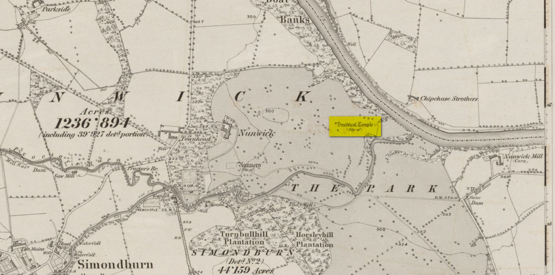
Site location on 1866 map
Highlighted, albeit in the past tense, as a “Druidical Temple” on the first Ordnance Survey map of the area in 1866, these megalithic remains were seen by earlier antiquarians, but seemingly met their demise sometime in the early 19th century. Some halfwit land-owners no doubt wanted their little garden extended to where local folk would have traditionally met at certain times each year—so in getting rid of the stones, it would help to keep the riff-raff away. (many of these elitists still think this way) It had certainly gone when the Northumbrian historian John Bates (1895) wrote about it, where he told simply:
“The fine circle at Nunwick, on North Tyne, described by Bishop Gibson, has long since disappeared.”
It was still standing in the 17th century, three or four thousand years after our ancestors put it there. We know this because the remains of the stone circle were told about in Gibson’s (1695) edition of Camden’s Britannia, where mention is made of “large stones erected at several places” in Northumberland, including this place where,
“near Ninwick in the Parish of Simondburn, four such stand still erected, and a fifth lies fall’n to the ground.”
The situation hadn’t changed when John Wallis (1769) visited Nunwick. On his trip to these megaliths he told that,
“In an adjoining field, called, Nunwick-east-field, were five upright stone-pillars, in a circular order; four of them perfect and entire in 1714, the other broken; the perfect ones eight feet high, and nine feet and an half over; the circumference of the area in which they stood, ninety feet.”
It was obvisouly a decent-sized circle! The great megalithic archaeologists Barnatt (1989) and Burl (2000) included the site in their respective catalogues, but could add no further details apart from saying there was a drawing made of the stones sometime around 1715 which, apparently, is in volume 15 of the History of Northumberland. Has anyone got a copy…? 🙂
References:
Barnatt, John, Stone Circles of Britain– volume 2, BAR: Oxford 1989.
Bates, John C., The History of Northumberland, Elliot Stock: London 1895.
Burl, Aubrey, The Stone Circles of Britain, Ireland and Brittany, Yale University Press 2000.
Dodds, M.H. (ed.), A History of Northumberland – volume 15: Simonburn, Rothbury, Alwinton, etc, Andrew Reid: Newcastle-upon-Tyne, 1935.
Gibson, Edmund (ed.), Camden’s Britannia, F. Collins: London 1695.
Wallis, John, The Natural History and Antiquities of Northumberland – volume 2, W. & W. Strahan: London 1769.
Acknowledgements: Huge thanks for use of the Ordnance Survey map in this site profile, reproduced with the kind permission of the National Library of Scotland.
From Pitlochry town centre, walk down the A924 high street as if you’re going to the Blair Atholl Distillery, but just before it take the right-turn and go over the river, and just keeping walking along this road for a third-of-a-mile (0.5km) until your reach a small small on your left that swerves up the hill (there’s a little signpost here saying Cluny Path to Strathtay). Go up and across the main road, then just keeping walking up the dirt-track, which becomes a footpath, and heads further uphill into and through the woodland. Make a bittova daydream from the walk up here, making sure to keep to the path closest to the burn (stream) on your left. Eventually when it levels out, you’re very close. Just keep on the same track and, where it meets up with another, bear left and about 100 yards along, on a small rise in the trees on your right, you’ll see these old stones peeking out. Keep your wits about you!
Archaeology & History
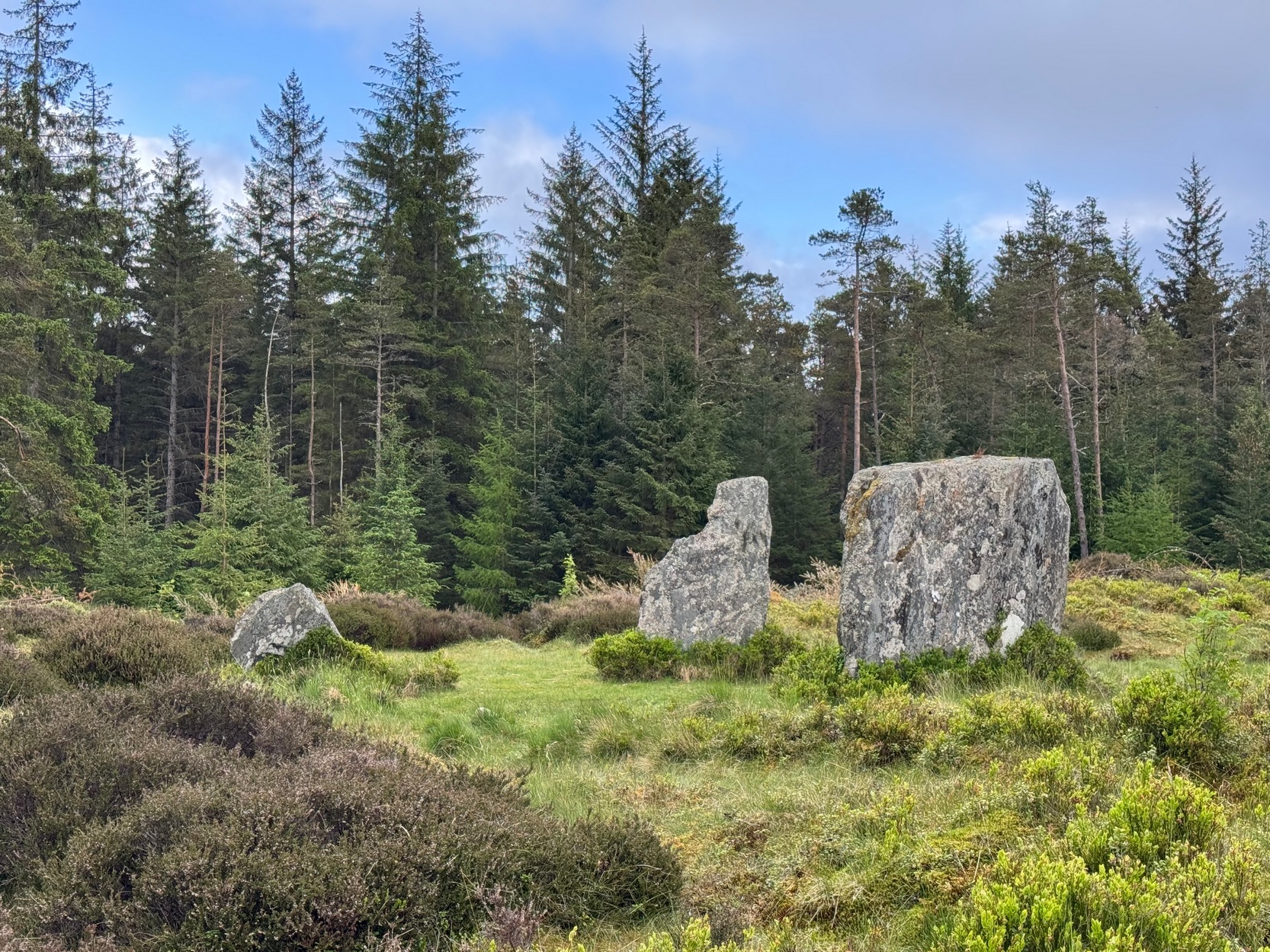
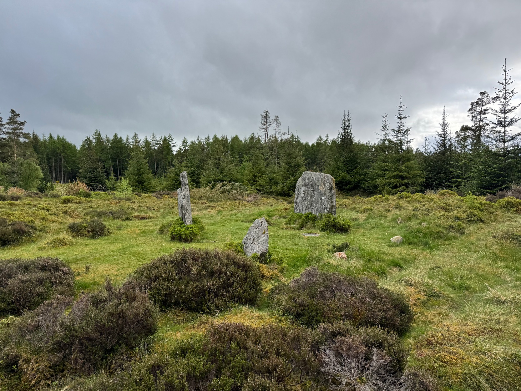
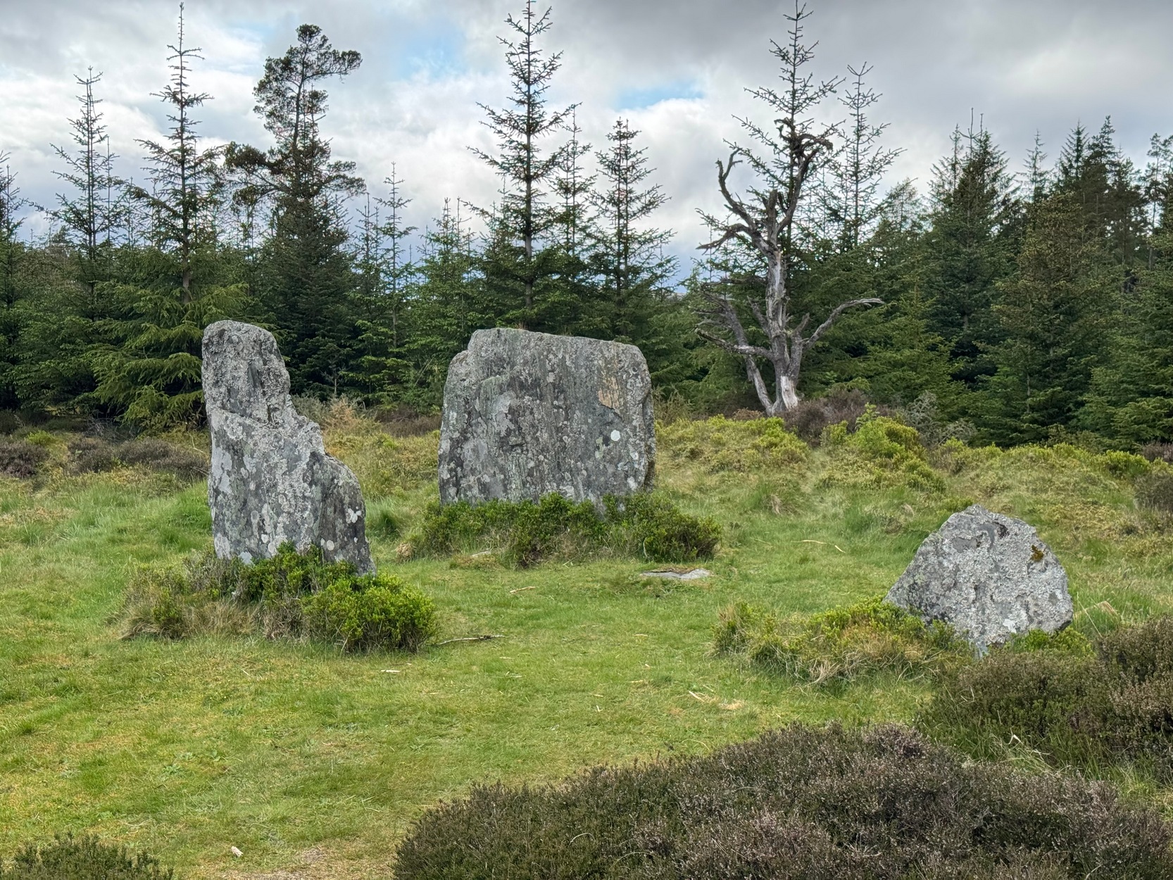
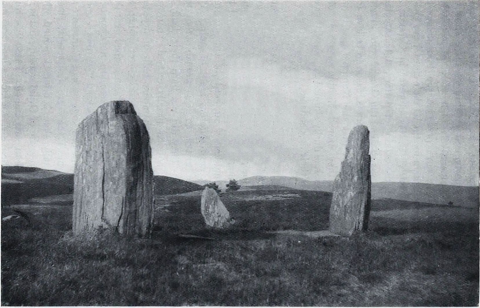
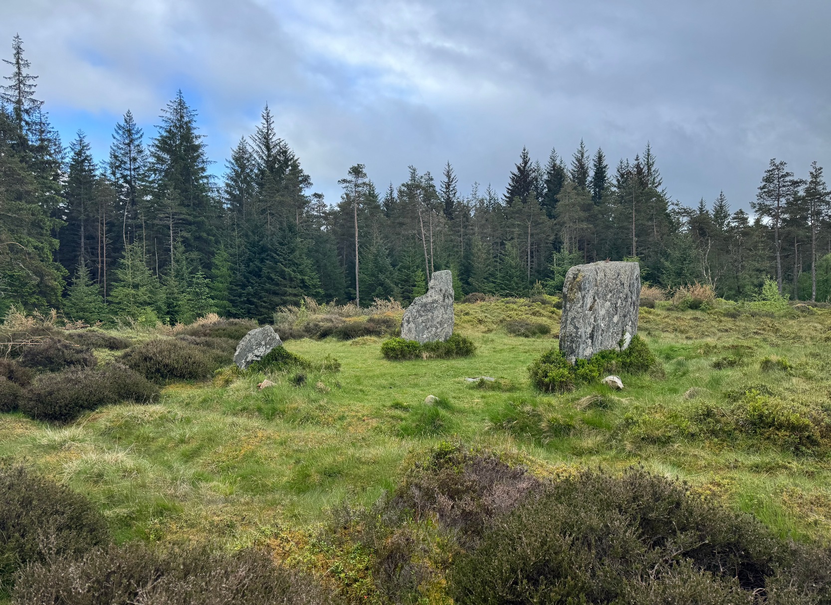
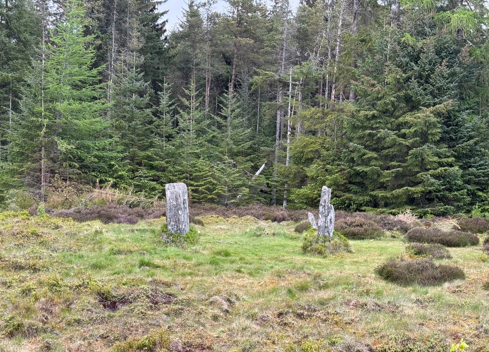
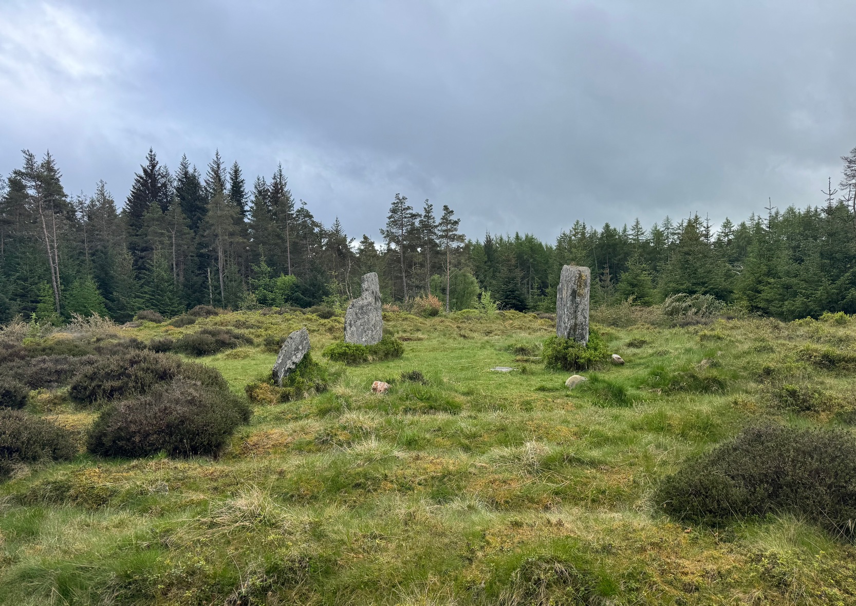
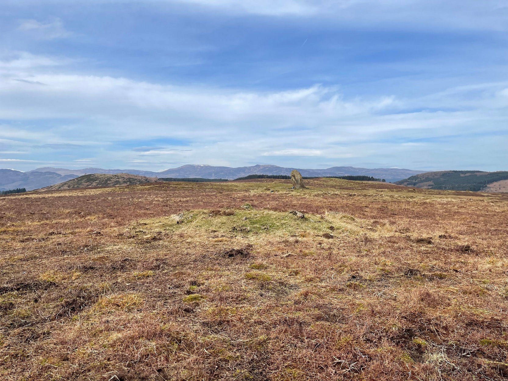
Clachan an Diridh looking E
Sat high up on open moorlands with views all round… is what this site used to look like. Sadly, the forestry commission have almost completely enclosed this prehistoric site, making any view of the surrounding landscape all but impossible. I’m not the first and won’t be the last person to be pissed-off by such thoughtlessness. Alexander Thom made mention of it too. After making an initial assessment of the astronomical alignments at these stones in 1967, “when we returned to measure the horizon we found that trees had been planted round the stones and so we failed.” (Thom 1990) Not good.
On my first visit here, as I entered this “stone circle” my first impression was that it wasn’t a circle at all, but the remnants of a megalithic stone row! Thom thought the same. It’s the slender thin stature of the stones that do it to you: they almost cut the air and point the enquiring nose dead straight along the same angle that all the stones have been deliberately aligned to. I assume they’ve had a similar effect on other people over the years.
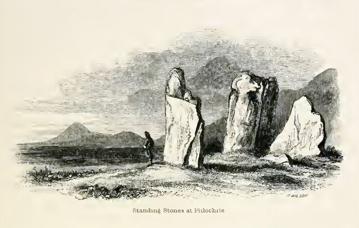
The Clachan an Diridh, or the Stones on the Ascent, were first mentioned in Dan Wilson’s (1851) major survey and who was so impressed by the view from here and its setting in the landscape that he compared its visage to Stonehenge. Were it not for the short-sightedness of the Forestry Commission destroying the view, most would no doubt agree with Wilson’s sentiments. From these olde stones, he told:
“One of the great level Highland moors stretches away beneath the eye, like a dark waveless lake, contrasting with the distant heights, among which Ben Lawers rears its pyramidal summit to an elevation of upwards of 4000 feet above the level of the sea. Amid this wild Highland landscape the huge standing stones, grey with the moss of ages, produce a singularly grand and imposing effect; and from the idea of lofty height which the distant mountains suggest, they convey a stronger impression of gigantic proportions than is produced even by the first sight of the giant monoliths of Salisbury Plain.”
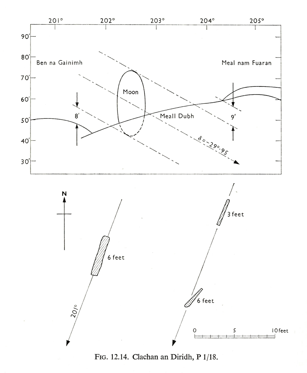
Thom’s initial moonset alignmentThom’s 1980 ground-plan with marker stone
The giant figure of Ben Lawers, if we could see it today, would rise to the southwest 20 miles (32km) from here; and the great pyramidal fairy mountain of Schiehallion would be equinox west, 13 miles (21km) away. Yet curiously when Alexander Thom surveyed the outlying hills, he didn’t think either of these mountains had any worth, astronomically speaking that is. Yet Lawers in particular would be the largest point on the southwestern horizon, rising in the distance, way beyond the wide rolling U-shaped glen of Strathtay to where the landscape changes into more rugged dynamic uplands. And the importance of Lawers as a place in prehistory is shown by the mass of petroglyphs across its slopes—particularly the side you could see from Clachan an Diridh.
Instead, Thom (1967) looked much further to the southwest—south-southwest in fact—where he initially thought that there was an alignment to the major southern moonset ten miles away above the rugged hill of Meall Dubh, framed on either side by the mountain peaks of Meall nam Fuaran and Beinn na Gainimh. Aubrey Burl (1988) told how Thom later discounted this alignment and instead turned his attention a full 180° where a large stone on the hillside to the north-northeast caught his theodolytic eye. This marked an alignment towards the peak of Ben Vrackie:
“There is little doubt,” he wrote, “that this is a lunar site showing perhaps…at the major standstill. Could one side of the southern 6ft high stone possibly have indicated the setting point of the Moon at minor standstill?” (Thom 1990)
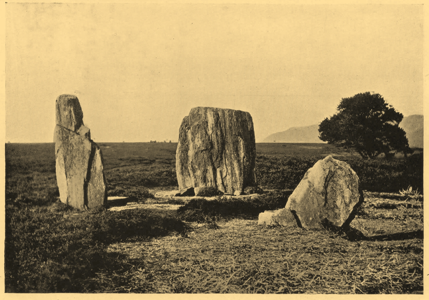
Clachan an Diridh in 1851Clachan an Diridh, c.1920
Thom looked at these stones and the landscape with the mind of an astronomer, whereas I’m more in preference of the aborigine who sees the feel of the landscape to discern relationships and meanings. Sometimes, of course, the sky and the landscape come together and that universal mythic union of heaven and Earth finds importance at a site. I have little doubt that such a mythos was once known here, on the moorland plateau, under the clear stars with the darkness reaching to speak with Lawers and other bones of landscape in the solid darkness of mountain silhouettes and fading horizons. Many a sleep at this site would have touched minds with Wonder…
Anyway, all that aside…
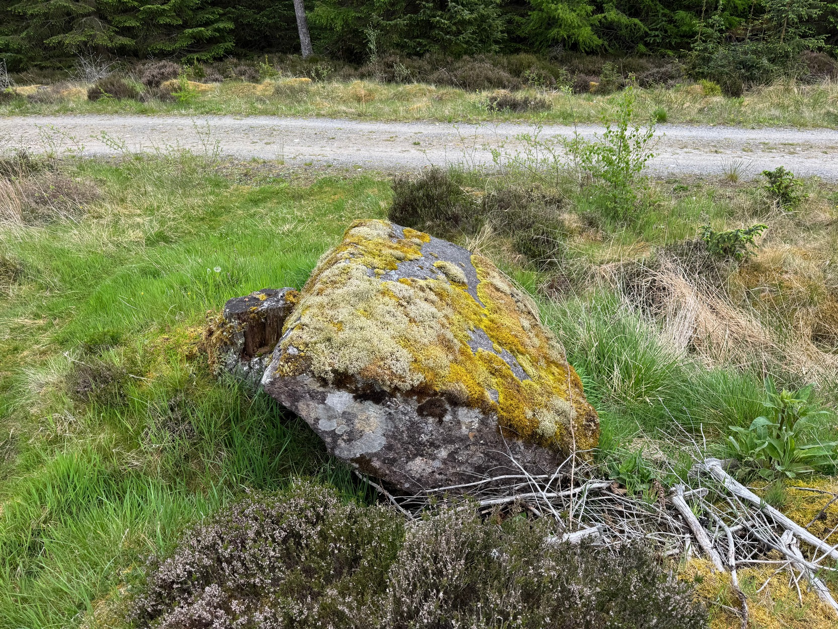
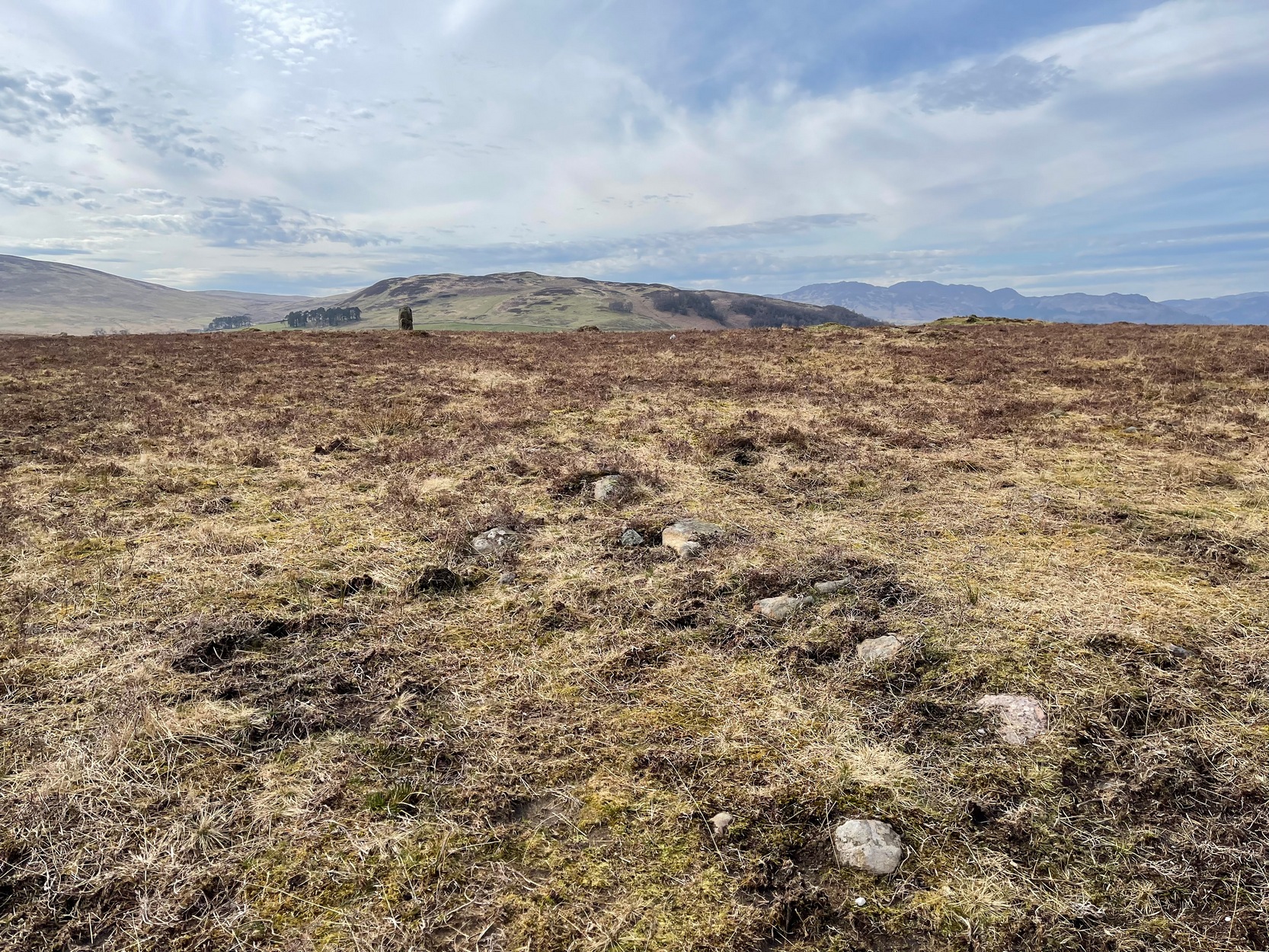
Large fallen stoneSite on the 1899 OS-map
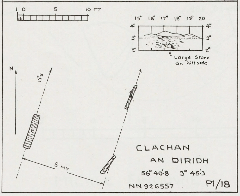
These megaliths have been classified as one of Aubrey Burl’s “four posters”, i.e., a rough square of four megalithic uprights, in spite of there only being three standing stones here. Even when Dan Wilson (1851) wrote about the place there were just three of them. However, down the slope from the stones, just off the recent trackside, there’s a decent contender for the fourth stone lying on its side in the undergrowth, half-covered in moss. It’s certainly fallen or rolled down the slope and its size and shape suggest that it may once have stood upright. Have a thoughtful fondle of it while you’re here.
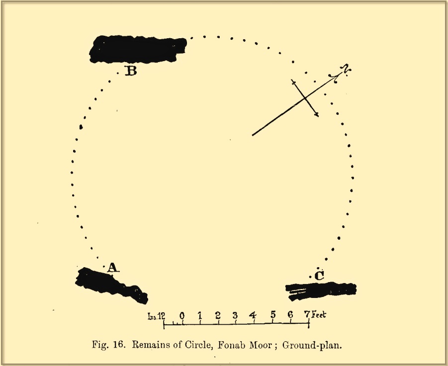
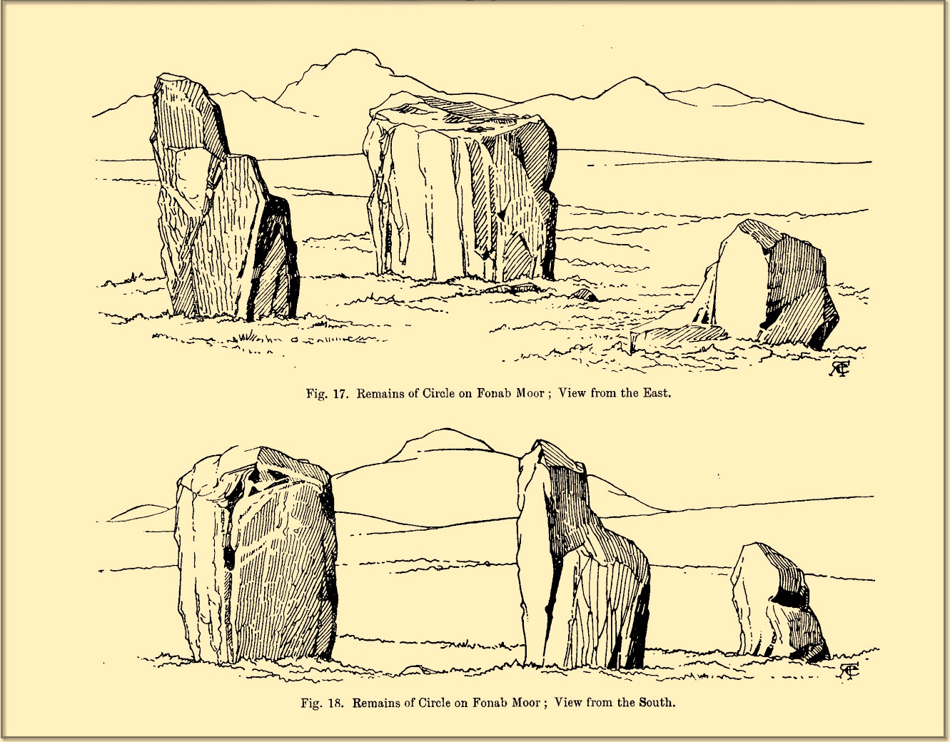
The ‘circle’ was highlighted on the 1899 OS-map and, a few years later, was visited and surveyed by the great Fred Coles (1908) and like Dan Wilson before him, told the view from here to be “very grand.” He continued:
Coles 1906 planColes’ views, from S & E
“In local parlance this group is known as the Four Stones. This must be a fairly old name handed down through some generations; because, for at least fifty-seven years past, only three Standing Stones have remained in situ. These three Stones are arranged as shown in the plan…in a group forming in its now imperfect condition a triangle which, measured from the centres of the Stones, has its SE side 11 feet 6 inches long; its SW side 12 feet 3 inches ; and its north side 16 feet 3 inches. Fragments of the demolished fourth Stone lie about the ground; but there is no clear indication of its original position. The South Stone, A, is 3 feet 7 inches in breadth, 5 feet 10 inches in height, and from 12 to 4 inches in thickness. The West Stone, B, 6 feet in height, measures 5 feet at the back, and 4 feet 10 inches at the front, and is 18 inches in thickness. The East Stone, C, at its outer angle is 3 feet 3 inches above ground, and leans inward. All the blocks are of quartziferous gritty sandstone, the East Stone being particularly rough and fissured. A large fragment lying near it seems to be a portion of it. The Stones are set upon a fairly true Circle with a diameter of 15 feet 4 inches. One feature quickly arrests notice: this is, that the broader faces of these Stones are not set even approximately upon and in line with the circumference, but nearly parallel with each other—an arrangement quite unlike the setting of Stones in the many other Circles hitherto surveyed.”
When Burl (1988) added this site to his Four Posters survey he merely echoed Coles’ early description, adding that, in his view, the standing stones that we see today were probably, originally, “set out on the circumference of a circle 20ft (6.1m) in diameter.”
I think it’s likely that there would have been more prehistoric sites in the vicinity, but a notable oddity is the almost complete absence of other recorded sites anywhere nearby. Of course, if there was anything, those thoughtful Forestry Commission heads would have destroyed it. We are left, simply, with the old but reliable notes of Messrs Dixon (1923) and Mitchell (1925) who told that, in their days, other remains did exist nearby in the form of ancient cairns and hut circles—‘Pictish’ according to tradition. If we’re lucky, some damaged parts of them might still be found at the edges, a short distance to the north west…
Folklore
In Hugh MacMillan’s (1901) gorgeous literary sojourn along Strathtay, he strayed somewhat from his otherwise historical notices by telling that here,
“on the highest part of the moorland…is a group of ‘clachan iobairt’, or stones of worship, where the Druids of old performed their mysterious rites, going round the circle of standing stones from east to west with the sun, or the ‘car deasal’, the lucky side, when they wished to invoke a blessing upon their friends, and going round the circle in the opposite direction, from west to east, the ‘car tuathsel’, or unlucky side, when they wished to pronounce a curse upon their foes.”
Whether this was what Hugh Mitchell (1923) meant when he referred to the traditions surrounding Clachan an Dirirdh we don’t know, but he echoed MacMillan’s account (though made no reference of his words), also adding that it was a site that “was visited on the first of May” or Beltane by some local people….
References:
Burl, Aubrey, Four Posters: Bronze Age Stone Circles of Western Europe, BAR 195: Oxford 1988.
Burl, Aubrey, A Guide to the Stone Circles of Britain, Ireland and Brittany, New Haven & London 1995.
Burl, Aubrey, The Stone Circles of Britain, Ireland and Brittany, Yale University Press 2000.
Dixon, John H., Pitlochry, Past and Present, L. Mackay: Pitlochry 1925.
Kennedy, James, Folklore and Reminiscences of Strathtay and Grandtully, Munro Press: Perth 1927.
Liddell, Colin, Pitlochry – Heritage of a Highland District, PKDL: Perth 1993.
MacMillan, Hugh, The Highland Tay: From its Source to Dunkeld, H. Virtue: London 1901.
Mitchell, Hugh, Pitlochry District: Its Topography, Archaeology and History, L. Mackay: Pitlochry 1923.
Omand, Donald (ed.), The Perthshire Book, Birlinn: Edinburgh 1999.
Stevenson, J., “Prehistory,” in Omand’s The Perthshire Book, Edinburgh 1999.
Thom, Alexander, Megalithic Sites in Britain, Oxford University Press 1967.
Thom, Alexander, Megalithic Lunar Observatories, Oxford University Press 1971.
Thom, A., Thom, A.S. & Burl, H.A.W., Megalithic Rings, BAR: Oxford 1980.
Thom, A., Thom, A.S. & Burl, Aubrey, Stone Rows and Standing Stones – volume 2, BAR: Oxford 1990.
Wilson, Daniel, The Archaeology and Prehistoric Annals of Scotland, Sutherland & Knox: Edinburgh 1851.
Acknowledgements: Huge thanks for use of the Ordnance Survey map in this site profile, reproduced with the kind permission of the National Library of Scotland.
Just as you’re coming into Balnaguard village on the B898 road from the eastern side (as if you’ve come via the A9 from near Pitlochry), just where the road crosses a small burn (stream), take the first farm-track on your right and walk down to the end where it meets the field. Here, walk to your left left and you’ll see a gate that takes you into the field. You should have already noticed the standing stone before you even open the gate! It’s about 100 yards in front of you. You can’t really miss it.
Archaeology & History
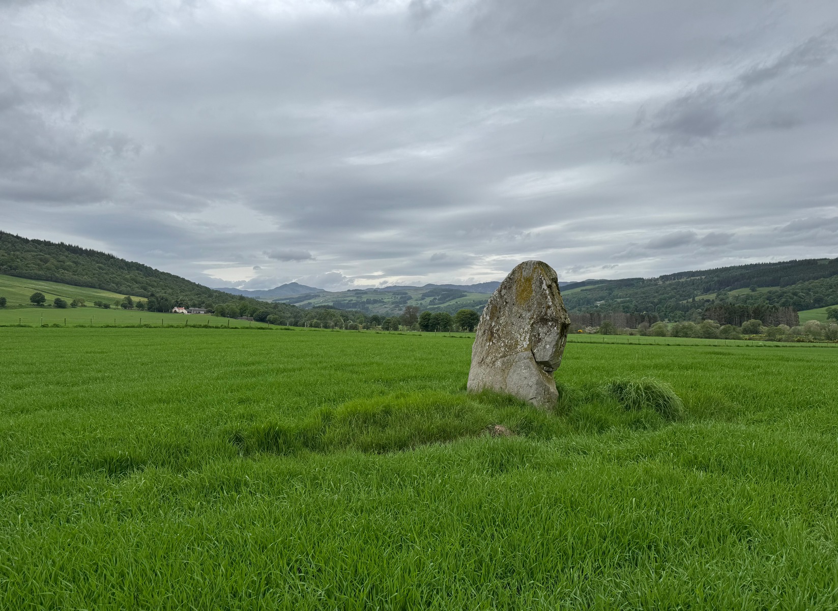
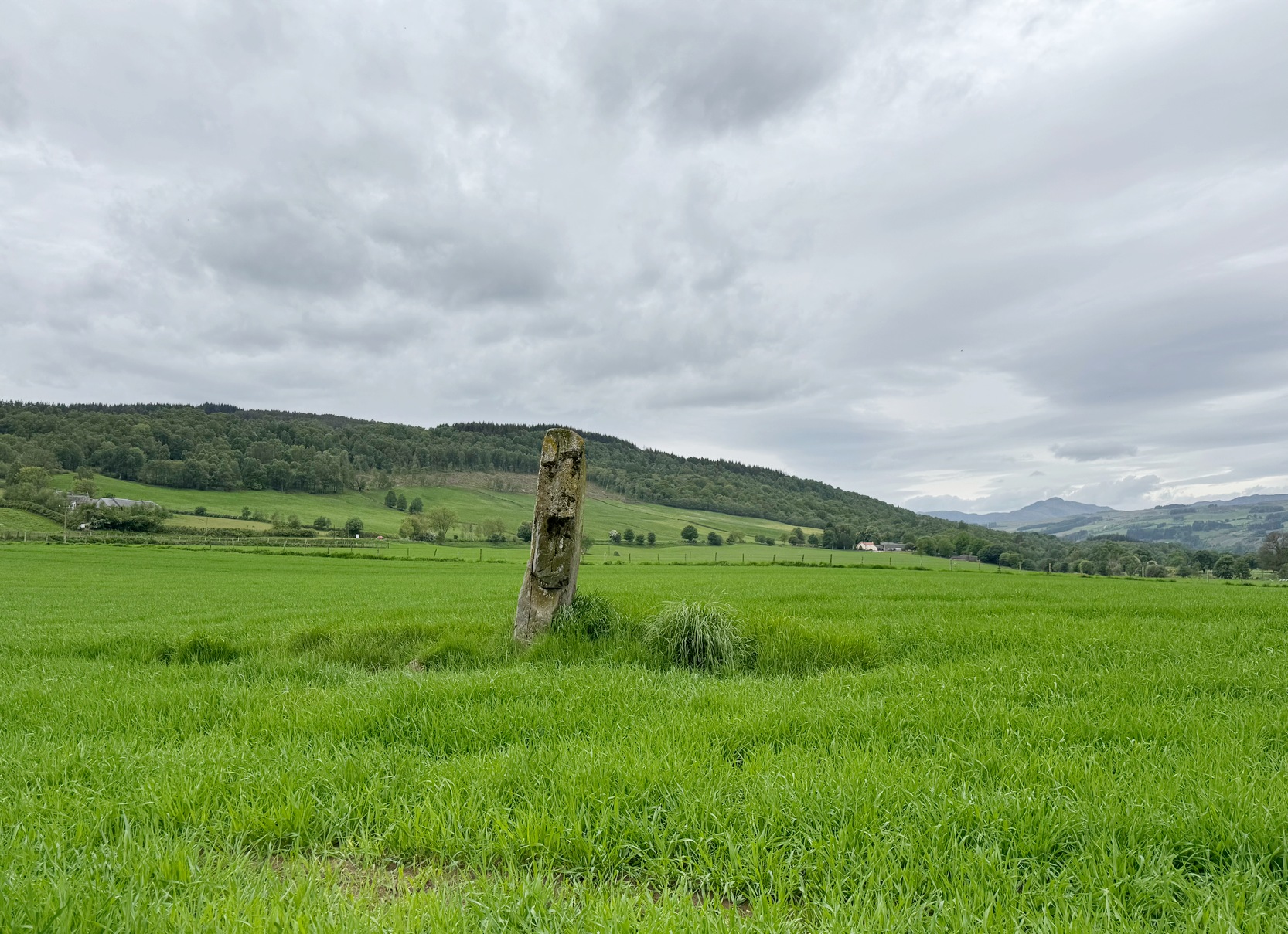
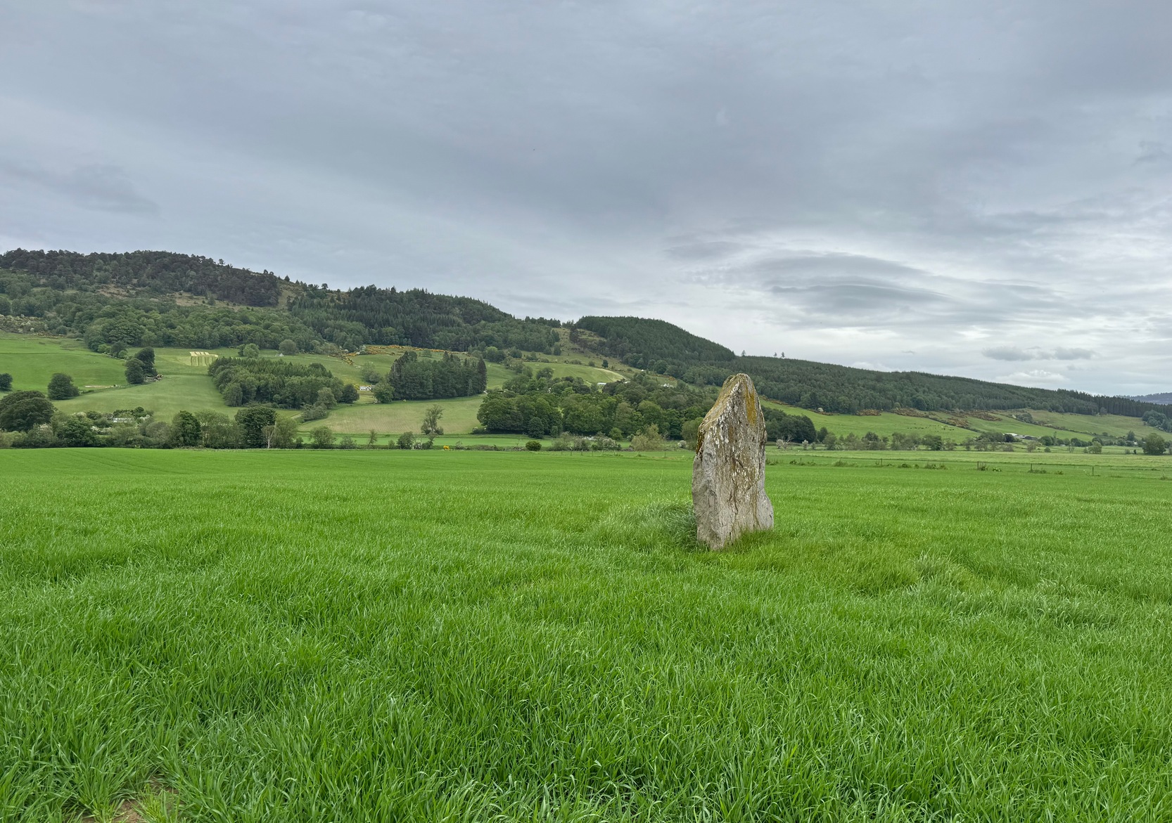
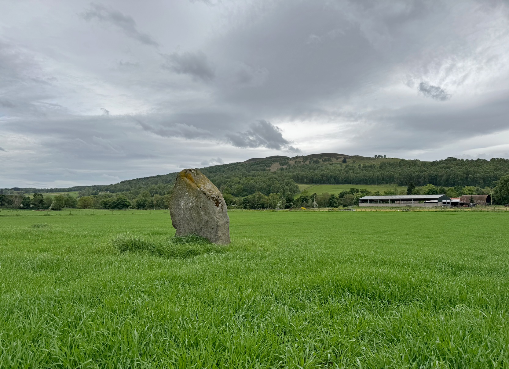
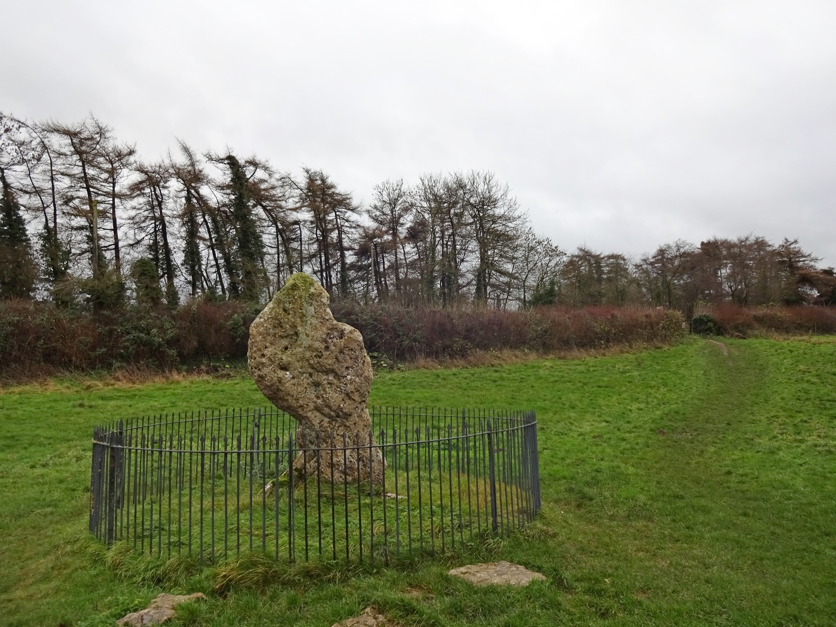
Clach na Croiche
Standing alone in this field a short distance south of the River Tay is this fine old standing stone, nearly seven feet high, from whose locale we gaze west to the opening of the Perthshire mountains—but in times gone by it wasn’t alone. Less than 10 yards east of the Clach na Croiche stood another seven-foot tall standing stone and, some six yards further east (and along the same axis) there may have stood another one, some 7½ feet high. This alignment ran east-west in line with the rising and setting of the sun at the equinoxes. (whether that was deliberate or not is another matter altogether) and was first noticed by the great antiquarian Fred Coles (1904) in one of his many megalithic ventures. He wondered “whether they (were) fallen Standing Stones, or the covers of cists” and when they were looked at by Margaret Stewart in 1971 she found that one of them laid beside “a shallow socket outlined with packing stones”—meaning that it had stood upright. The other stone didn’t seem as certain, although Stewart did report finding “a single cupmark…on the eastern side of the upper surface.” We’ve yet to see a photo of this carving.
The Clach na Croiche also has its own cup-markings, just above the bottom of the stone on its southern-face. Margaret Stewart described them as being “strung out irregularly across the face.” Sounds about right! Sadly, somehow, I didn’t get any photos of these when I last visited, but will grab some the next time I’m there.
Looking to the westLooking to the northeast
In the fields either side of the stones, ancient tombs have been found. Around 1887, the Duke of Atholl dug under some of the stones in the field and found a “cup” or urn which Coles reported “was found in a cist in the haugh near Tom-na-Croiche.” Then, in 1969, the farmer John MacBeth was ploughing the field and unearthed another cist some 15 yards north-west of the present upright. The base of the cist was cobbled and whilst whilst the tomb itself was filled-in, the farmer moved the covering stone to the fence at the west-side of the field (NN 9455 5205). Also, on the eastern side of the field in 1971, Stewart reported finding what she thought were the remains of cremated bones that seemed to have been part of another prehistoric structure.
Fred Cole’s 1904 sketchLooking to the southeast
Nearly 250 yards to the west of the stone, in the adjacent field, a huge prehistoric cairn—known as the Sketewan Cairn—was uncovered and fully excavated in the late 1980s. It originally stood some four feet high and was nearly seventy feet across. Within the cairn complex, a small standing stone accompanied some cremations. Unfortunately this entire archaeological site has since been completely covered over. You wouldn’t even know it was there if you stood right next to it! But if you want to see Balnaguard’s remaining tombs, head for the Fairy Mound right in the heart of the village…
Dixon, John H., Pitlochry, Past and Present, L. Mackay: Pitlochry 1925.
Kennedy, James, Folklore and Reminiscences of Strathtay and Grandtully, Munro Press: Perth 1927.
Omand, Donald (ed.), The Perthshire Book, Birlinn: Edinburgh 1999.
Stevenson, J., “Prehistory,” in Omand’s The Perthshire Book, Edinburgh 1999.
Stewart, Margaret E.C., “Perthshire: Balnaguard”, in Discovery & Excavation in Scotland, 1971.
Swarbrick, Olaf, A Gazetteer of Prehistoric Standing Stones in Great Britain, BAR: Oxford 2012.
Yellowlees, Sonia, Cupmarked Stones in Strathtay, Scotland Magazine: Edinburgh 2004.
Acknowledgements: Huge thanks for use of the Ordnance Survey map in this site profile, reproduced with the kind permission of the National Library of Scotland.
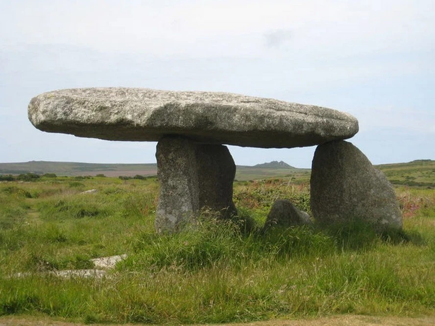
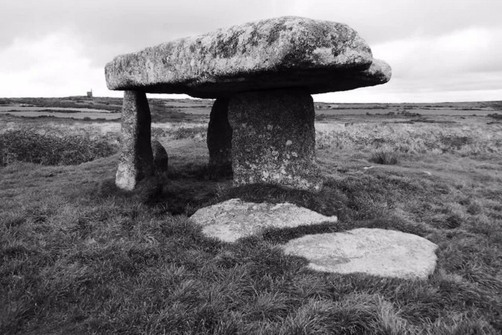
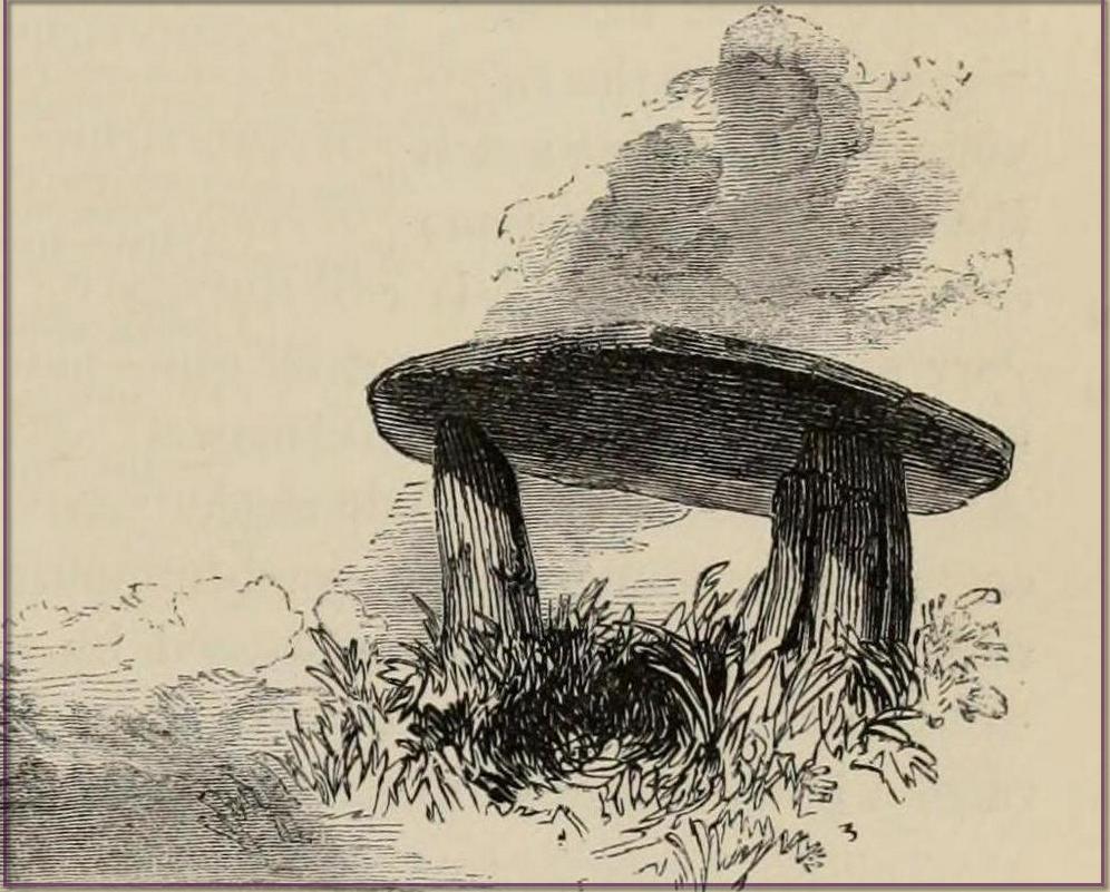
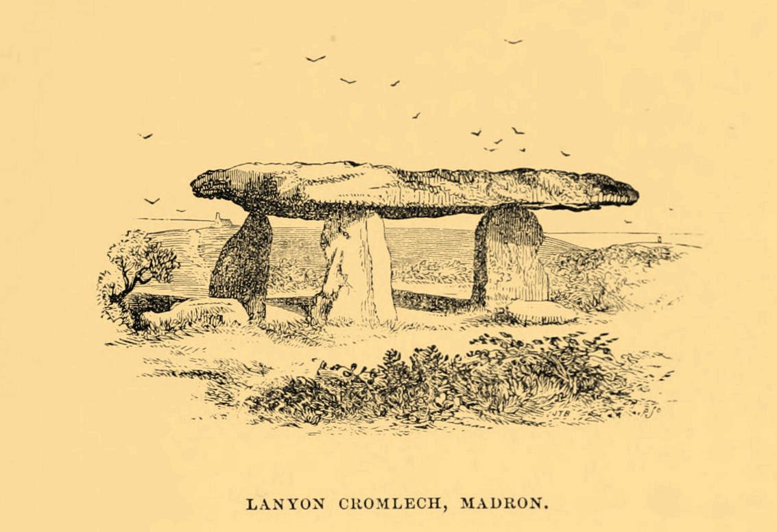
William Borlase (1769), in his revised classic on the megaliths & antiquities of Cornwall, wrote:
“Since we are now considering these Stone-monuments, there is a very singular Monument in the Parish of Madern (Cornwall) which in this place, will naturally offer itself to our enquiry. In the Tenement of Lanyon stand three Stones-erect on a triangular Plan. The shape, size, distance and bearing, will best be discerned from the plan and elevation of them…
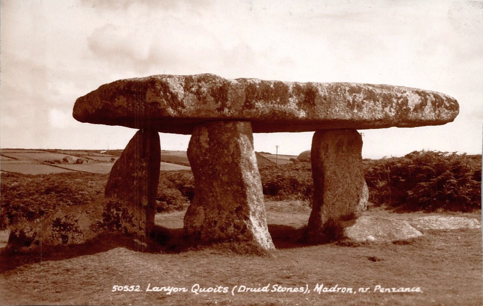
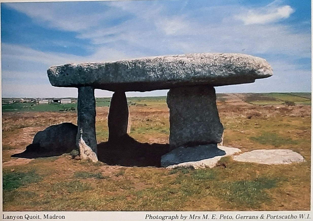
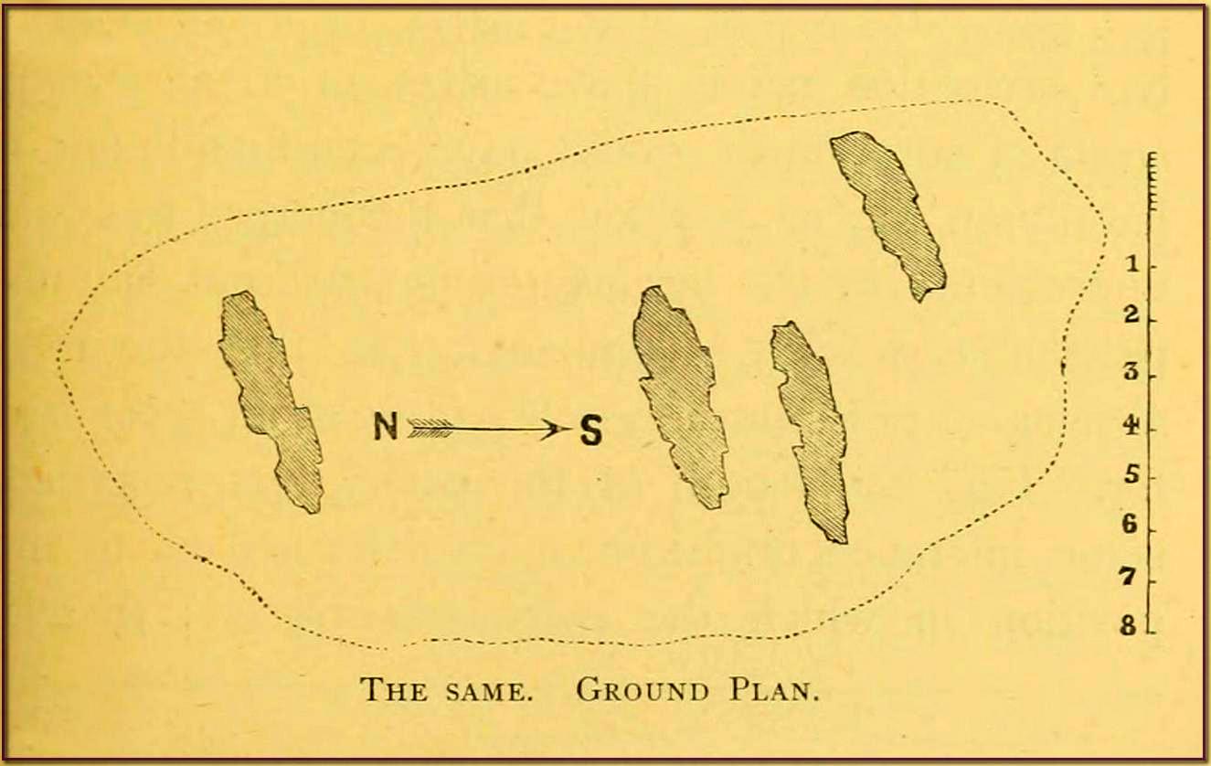
“The length of the area described by the supporters of Lanyon Quoit is seven feet; but it does not ſtand East and West, as at Molfra, but North and South… There is no Kist-vaen, that is, no area marked out by Side Stones, under this Quoit, which is more than 47 feet in girt, nineteen feet long; its thickness in the middle, on the Eastern edge, is sixteen inches, at each end not so much, but at the Western edge this Quoit is two feet thick. The two chief supporters…do not stand at right angles with the front line, as in other Cromlehs, but obliquely, being forced from their original position, as I imagine, by the weight of this Quoit, which is also so high that a man can fit on horseback under it. Under this Quoit I caused to be sunk a pit of four feet and half deep, and found it all black earth that had been moved, and should have sunk still deeper, but that the Gentleman in whose ground it is, told me, that a few years before, the whole cavity had been opened (on account of some dream) to the full depth of six feet, and then the faster appeared, and they dug no deeper; that the cavity was in the shape of a grave, and had been rifled more than once, but that nothing was found more than ordinary. This Cromleh stands on a low bank of earth, not two feet higher than the adjacent soil, about 20 feet wide, and 70 long, running North and South: at the South end has many rough Stones, some pitched on end, in no order; yet not the natural furniture of the surface, but designedly put there; though, by the remains, it is difficult to say what their original poſition was. Wet N. W. there is a high stone about 80 yards distance. By the black earth thrown up in digging here, nothing is to be absolutely concluded, there having happened so many disturbances. By the pit being in the shape of a grave, and six feet deep, it is not improbable that a human body was interred here, and by the length of the bank, and the many disorderly stones at the South end, this should seem to have been a burial place for more than one person.”
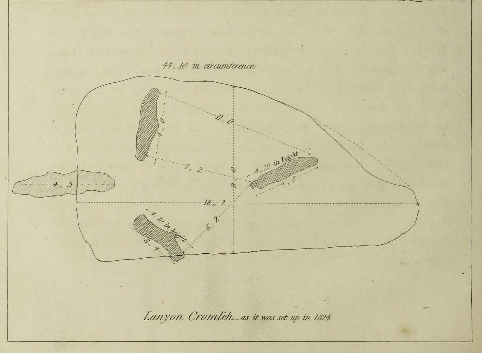
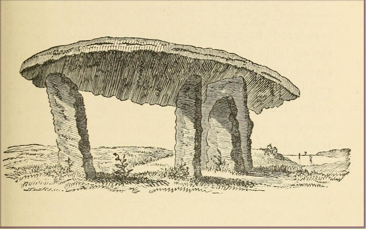
William Borlase 1769 ground-planWilliam Borlase 1769 sketch
Antiquarian Notes
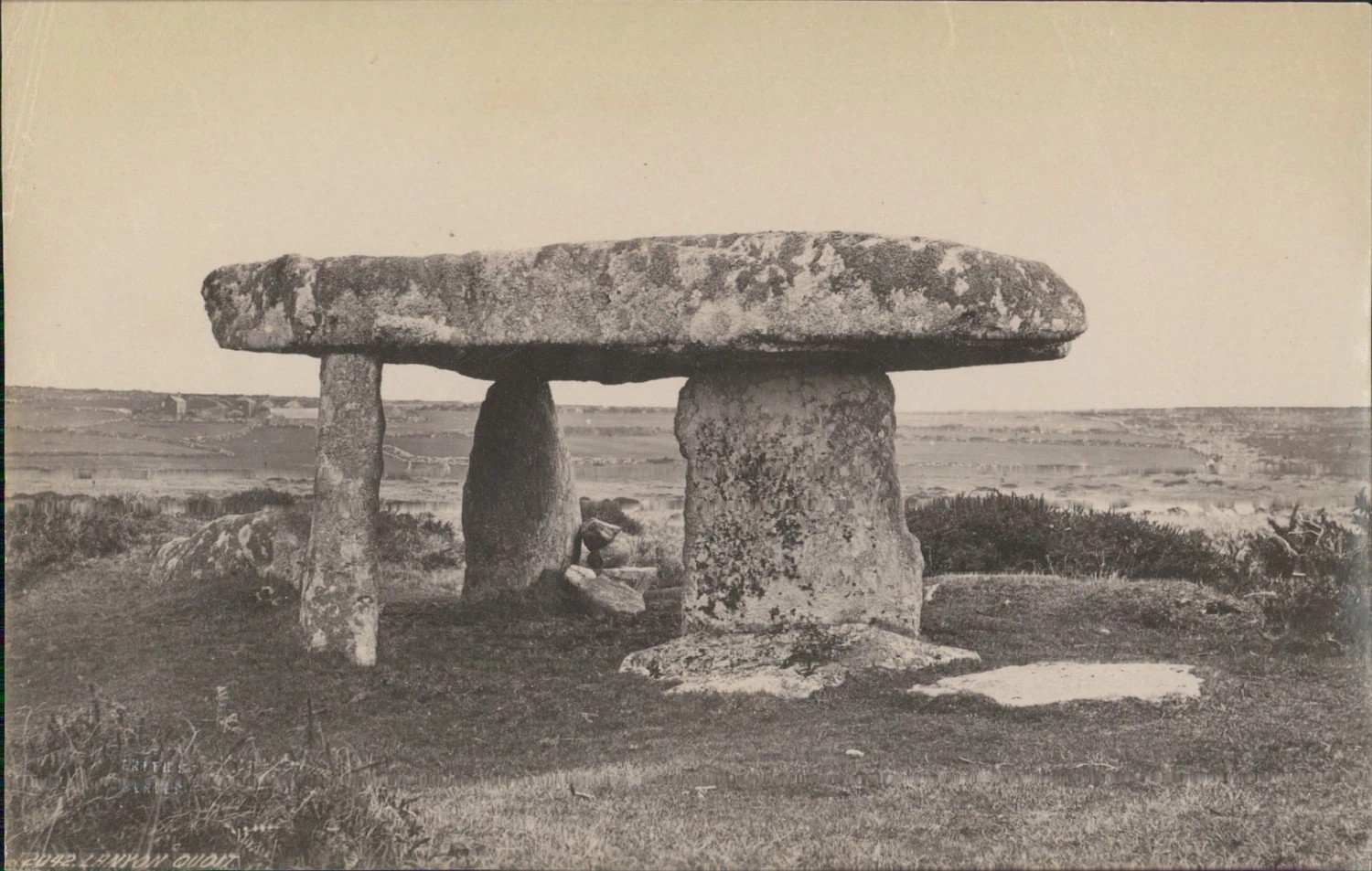
William Cotton, in 1827, told that:
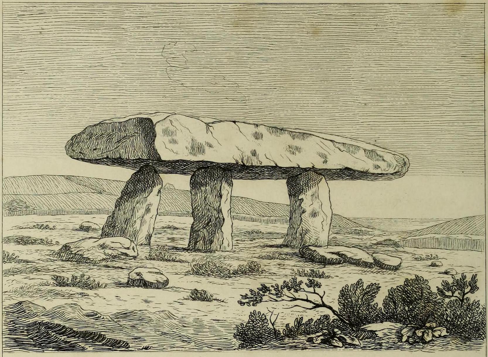
“About a mile and a half north of the church, in the parish of Maddern, and close to the road side, is Lanyon Cromleh, so called from the name of the estate on which it stands. The covering stone, which is nearly flat, and of a triangular figure, measures 44 feet 10 inches in circumference, 18 feet 2 inches in its greatest length, and 9 feet in width, and weighs 15 tons. This Quoit, as it is usually called, was originally supported on four upright stones, describing an open area 7 feet in length, north and south, but not forming an enclosed Kistvaen, like Molfra and Chun Cromlehs. During a very violent storm in the year 1815, when the Delhi East Indiaman was wrecked in Mount’s Bay, it fell to the ground, and one of the supporting stones was then broken. It is probable that the earth beneath it, having been frequently loosened by excavations, was washed away by the heavy rains, and caused its downfal. In the year 1824 it was again set up, by subscription among the inhabitants, with the machinery used in replacing the Logging Rock, under the superintendence of Captain Giddy, R.N., whose zealous exertions overcame every difficulty, and merit the thanks of all topographical antiquaries. The Cromleh now stands as firm as ever: in putting it up, a piece was broken off the top stone, at A, (see the plan). It is supported on three upright stones, each 4 feet 10 inches in height, the tops having been made level, and their positions a little altered.
“This view represents Lanyon Cromleh as it now stands, and differs from all the prints I have seen of it, — which have been uniformly copied from Dr. Borlase’s book, and do not, by any means, give a correct representation. The doctor says, in his time a man on horseback could ride under the incumbent stone — now, its height from the ground is only 4 feet 10 inches. The figures 1824, to mark the year when it was re-erected, have been rudely inscribed on one of the supporting stones.
“Dr. Borlase caused an excavation to be made under this Cromleh, as well as under the last mentioned, but without discovering any human bones ; he was led, however, to conclude, by the appearance of the earth, that a body had been interred there.”
Cotton’s 1827 sketch
Antiquarian Notes
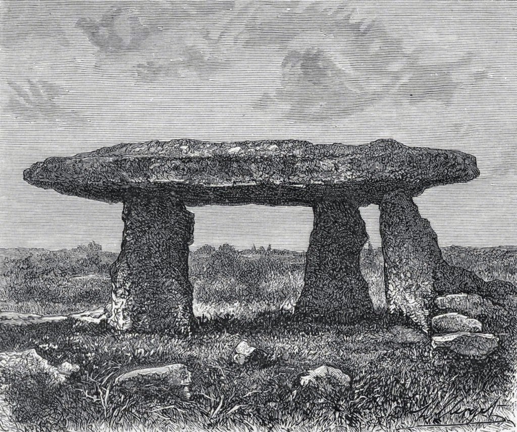
James Orchard Halliwell wrote, in 1861:
“At a distance of some five miles from Penzance, on the road from Madron to Morvah, near the road, on the right-hand side, is the Lanyon Quoit or Cromlech, a fine specimen, and perfect in all essential particulars. The best way of reaching it, if walking, is to take the path to the left in the fields after passing the Madron Union, and keep as nearly in a straight line as possible until the cromlech appears. It is situated in a conspicuous situation in the midst of a wild moor, and is interesting in its Titanic grandeur and vast antiquity. The top covering consists of an enormous flab of granite, supported by three upright unhewn blocks of stone, but near there are three fallen stones, one of which at least was certainly at one time one of the supporters. The dimensions of the cap-stone are thus given by Borlase: —
“This quoit is more than forty-seven feet in girt, and nineteen feet long ; its thickness in the middle on the eastern edge is sixteen inches, at each end not so much, but at the western edge it is two feet thick.”
This cromlech is sometimes called by the country people the Giant’s Quoit, and occasionally the Giant’s Table. My measurement made the covering-stone forty-fix feet in circumference, with a thickness varying from ten to eighteen inches. It is not improbable that the stone has been chipped off at one or two of the corners since the time of Borlase. Between the cromlech and the road are the remains of a stone and earth circular barrow about eighteen feet in diameter. There is an odd tradition that the first battle fought in England was decided in the locality of Lanyon Quoit.”
Blight, J.T., A Week at the Land’s End, Longmans Green: London 1861.
Borlase, William, Antiquities, Historical and Monumental, of the County of Cornwall, Bowyer & Nichols: London 1769.
Borlase, William Copeland, Nænia Cornubiæ, Longmans Green Reader: Truro 1872.
Colquhoun, Ithell, The Living Stones, Cornwall, Peter Owen: London 1957.
Cooke, Ian, Antiquities of West Cornwall – Guide 1, Cornwall Litho: Reduth 2002.
Halliwell, J.O., Rambles in Western Cornwall in the Footsteps of Giants, John Russel Smith: London 1861.
Jewitt, Llewellynn, Grave Mounds and their Contents, Groombridge: London 1870.
Redding, Cyrus, An Illustrated Itinerary of the County of Cornwall, How & Parsons: London 1842.
Russell, Vivien, West Penwith Survey, Cornwall Archaeological Society: Truro 1971.
Straffon, Cheryl, Megalithic Mysteries of Cornwall, Meyn Mamvro: Penzance 2004.
Acknowledgements: Huge thanks for use of the Ordnance Survey map in this site profile, reproduced with the kind permission of the National Library of Scotland.
Stone Circle (destroyed): OS Grid Reference – NO 332 430 (approximation)
Archaeology & History
This stone circle wasn’t logged in either Barnatt (19890 or Burl’s (2000) standard megalith inventories. The only mention of it seems to be in Alex Elliott’s (1911) rare work on the region, in which he described it as being located “within the grounds of Mylnefield”. All trace of it would seem to have gone. Elliott told it to have been,
“elliptical in form and consisted of six large boulders – three at the east, three at the west, with a gap between capable of holding an equal number of stones.”
References:
Elliott Alexander, Lochee – As it Was and As it Is, J.P. Mathew: Dundee 1911.
Stone Circle (destroyed): OS Grid Reference – NN 9020 0985
Also Known as:
Blackford Glebe
Brookfield House
Archaeology & History
In the 18th Century there stood, on the slight rise of the land about 150 yards south of Brookfield House, one of those “circles of stones…in the glebe”, of the sort that “are supposed to have been places of Druidical worship,” wrote John Stevenson. (1792) Sadly, sometime in the 19th Century, the entire site was uprooted and destroyed, leaving no trace of the place. Not good…. 🙁
References:
Stevenson, John, “Parish of Blackford,” in The Statistical Account of Scotland – volume 3, (edited by, John Sinclair) William Creech: Edinburgh 1792.
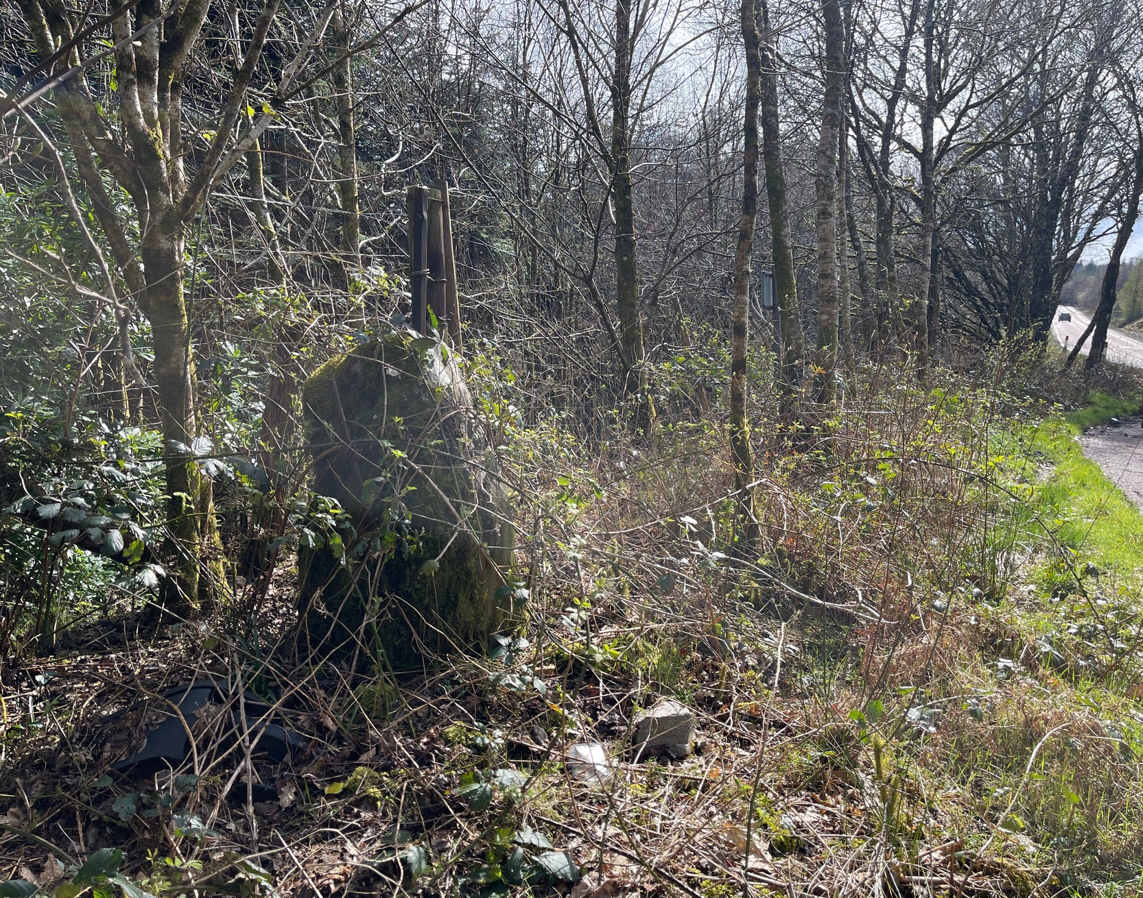
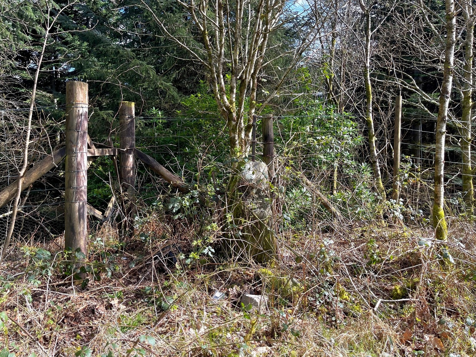
Along the A83 road, 2.6 miles (4.2km) south of Minard and/or 2.7 miles (4.4km) north of Lochgair village, an all-but-hidden parking area is on the east side of the road at the edge of the trees. Go in here and park up. Roughly halfway along where the track bends and set back against the fencing, you’ll see this obvious standing stone hiding away. If you visit this place in the summer months, it will be very hard to see. (in the event that you have the time and cutting ingredients, it’d be good to clear the stone from the undergrowth so it can be seen clearly)
Archaeology & History
Kilmichael Beg, looking E
Set back into the undergrowth of brambles and other spiney vegetation is this little-known standing stone, some four feet tall, that was converted for use as a gatepost at the end of the 19th century. It is said to have once been on the other side of the road before it was used in the line of fencing, when the metal rod coming out of the crown of the stone was inserted. The monolith is very worn and eroded on all sides, showing great age—seeming to affirm the local tradition of its antiquity. If anyone has any further information about this stone, please let us know.
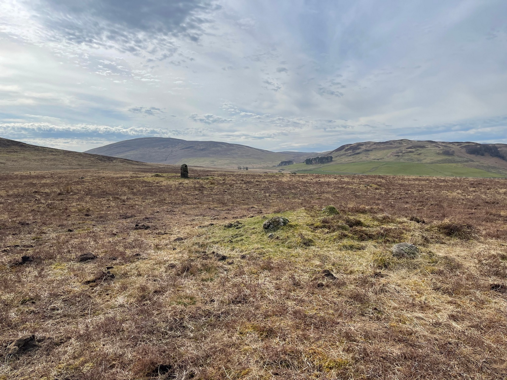
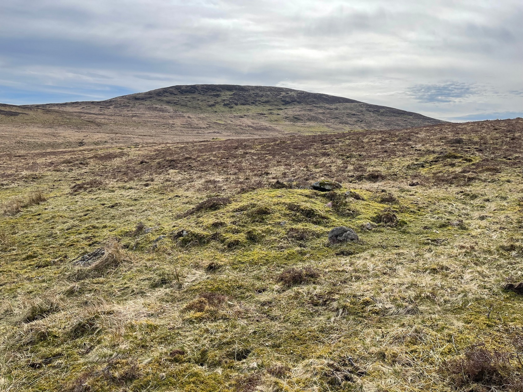
Simply follow the directions to reach the Dunruchan monoliths ‘D’ and ‘E’ and then zigzag through the heather to their immediate south—from just a few dozen yards away, to up to 300 yards west. Keep your eyes peeled for the stoney little rises in the heather as you walk back and forth and you’ll see at least some of these cairns.
Archaeology & History
Not to be confused with the large cairn scatter on the grassy plain of Aodann Mhor a short distance north-west (whereon stands the magisterial Dunruchan A monolith), many of which which may be just field clearance cairns. This small group found a short distance east, south and west of Dunruchan stones ‘D’ and ‘E’ are more typical burial cairns. They each average between five and six yards across and none are more than three feet high. We first noticed them about ten years ago and on subsequent visits kept looking them over, but the deep heather ensured they were hard to see. But, after a recent heather-burning exercise on the moors, they are at thankfully visible—for a short time at least.
Cairn SE of Dunruchan ‘D’
Cairn S of Dunruchan ‘D’
At the time of writing, probably the best one to see is found 40 yards south of Dunruchan D and 47 yards north-east of Dunruchan E and may have the astronomers amongst you running for the theodolites! It has that distinct look about it when you see it in context with the landscape and adjacent standing stones. The westernmost cairn that’s (presently) known here is 300 yards west of the Dunruchan E stone, just past the Dunruchan enclosure, at NN 7873 1676. It’s likely that there are other unrecorded prehistoric sites in this area.
Low line of ancient walling
Amidst this section of the moors is a line of very low walling that runs a short distance east-to-west, towards the Dunruchan ‘E’ stone. A lot of old walling exists hereby, mainly visible in the fields to the east, but this particular line is much smaller and of a different age by the look of things, presumably older. It has the appearance of walling more usually associated with prehistoric hut circles, but in this case runs in a straight line towards the standing stone. Curious…
Folklore
The standing stones on this plain and the cairns here are said to be the graves of fallen Roman soldiers, slain by our tribal Scots two thousand years ago. In all honesty though, these are likely to be much older than any of those Roman savages.
Standing Stone (lost): OS Grid Reference – NN 795 168
Archaeology & History
When Fred Coles (1911) visited the giant impressive Dunruchan standing stones, he told that “some distance to the east” of the Dunruchan E stone, “near the unnamed stream…my friend Mr James Simpson has seen another great Stone, but lying prostrate.” When he visited the area the weather beat him back (easily done up here!) and prevented him “from wandering far over the moor, and therefore this Stone was not observed.” It remains lost. (the grid-reference given for this site is an approximation)
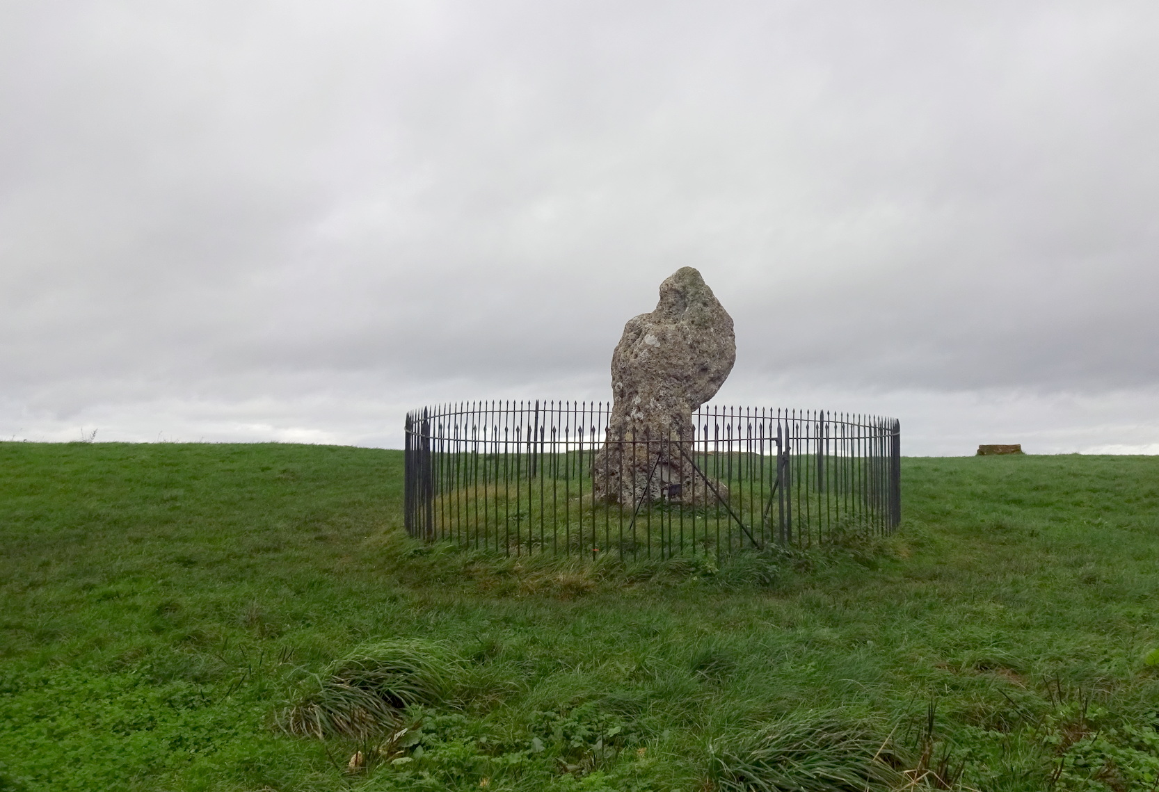
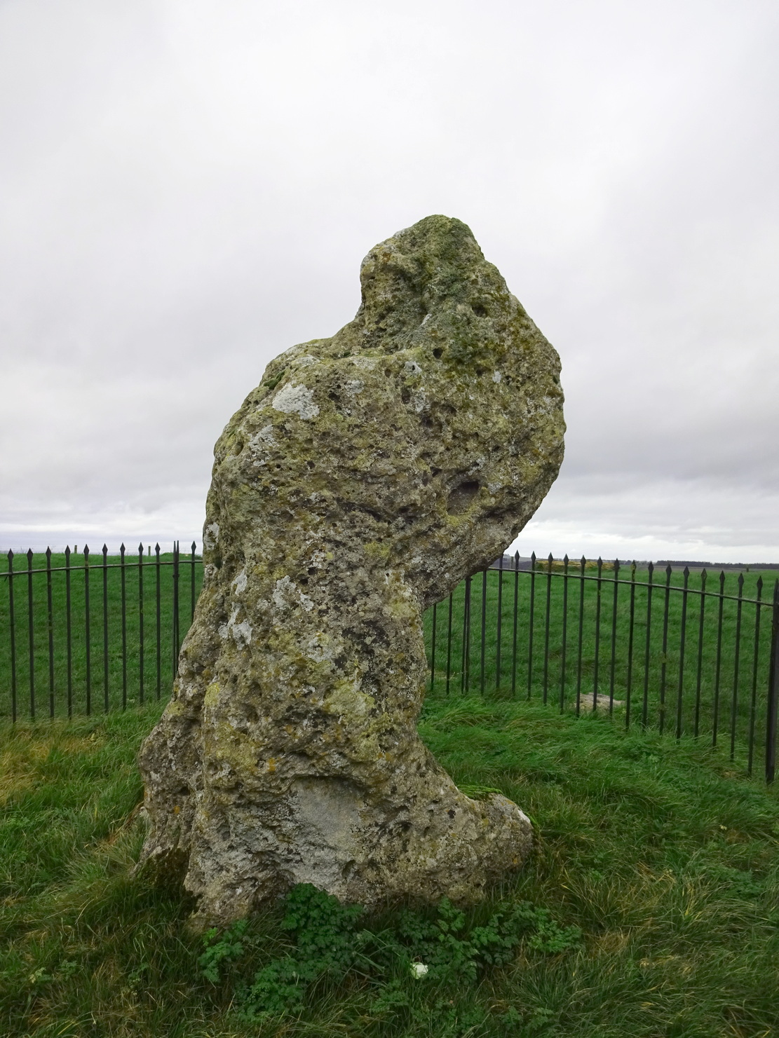
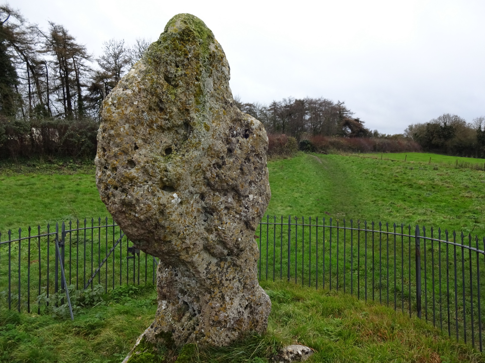
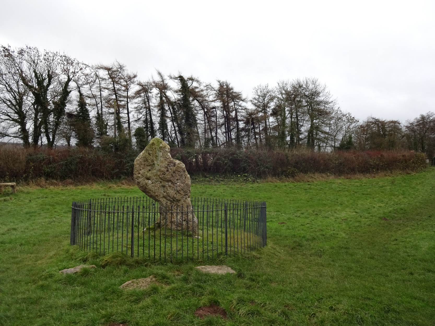
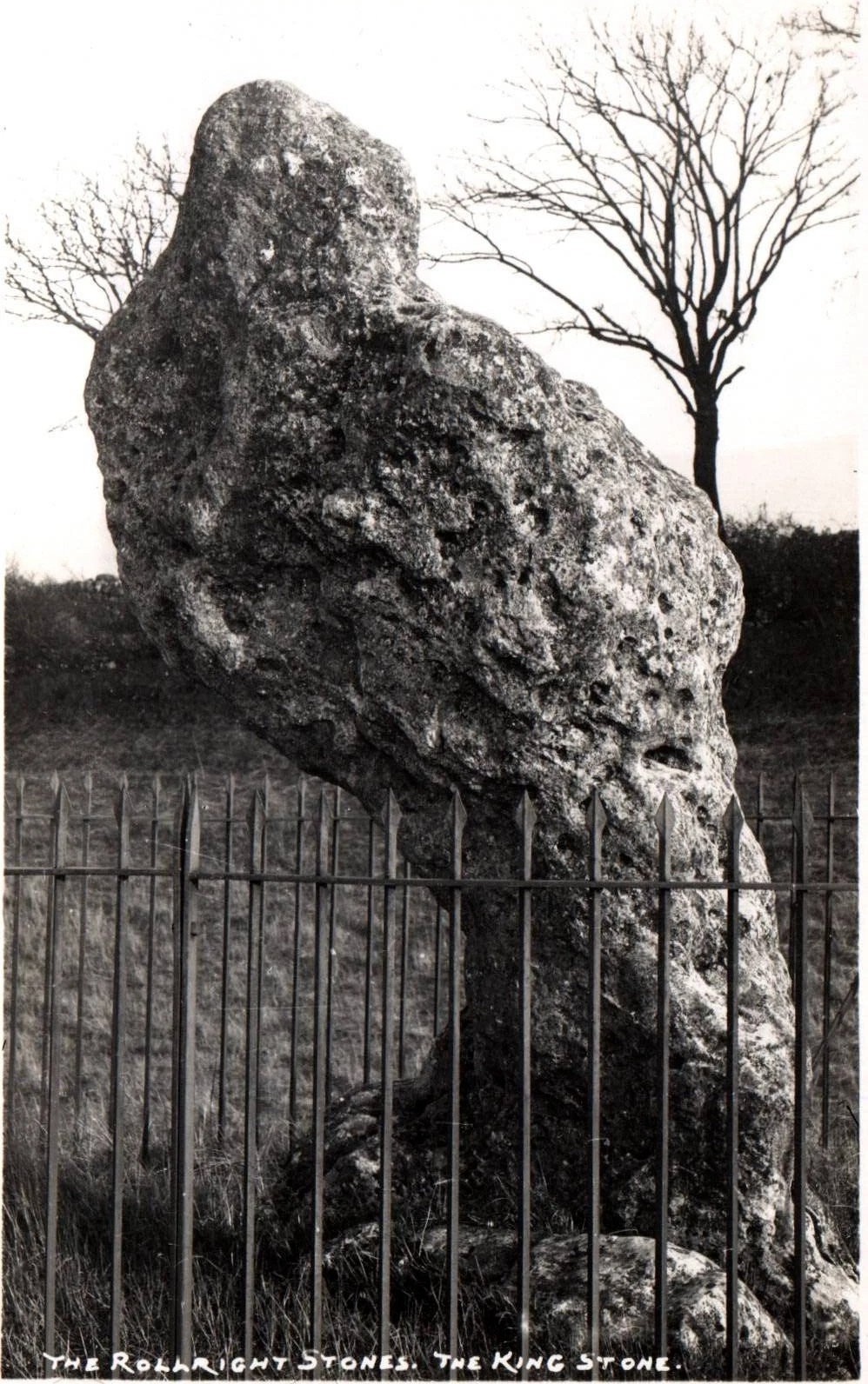
The King Stone of Rollright (photo by Sir Wilson III)
If you’ve reached the impressive Rollright Stone circle, simply cross the road, go through the gate and into the field, then up the gentle slope to your right. Y’ can’t miss it! If though, by any chance, you can’t find the Rollright Stones, get to Chipping Norton and ask a local!
Archaeology & History
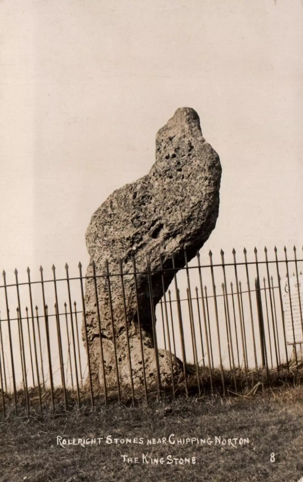
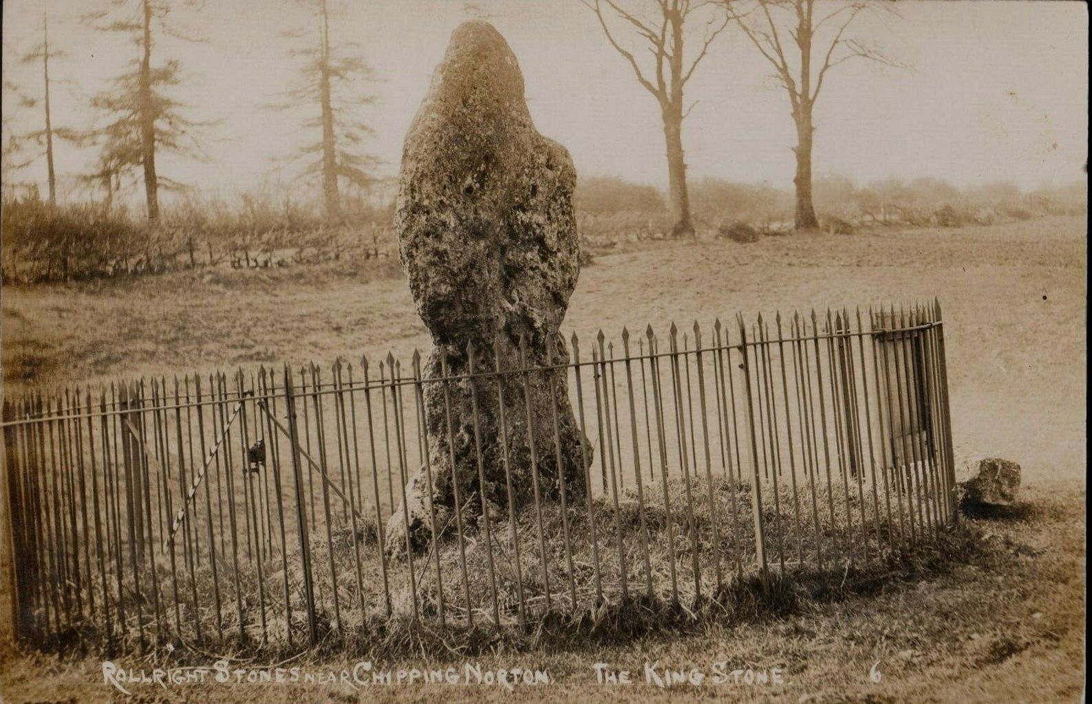
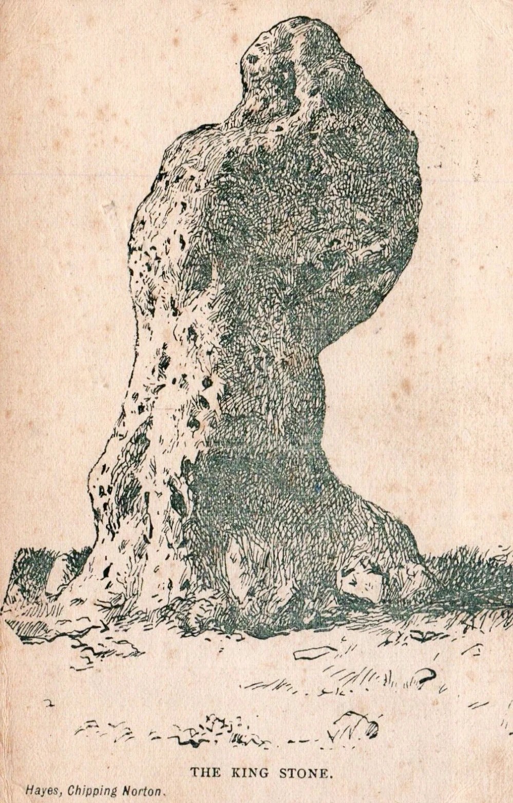
An integral part of the Rollright Stones complex, this gnarled almost moth-eaten-looking standing stone, whose edges were cut away for medicinal properties in earlier centuries, still awakes each morning beside the small rise in the field, long thought to have been the remains of an ancient tomb — much to the archaeologist’s opinionated disdain in bygone years. Yet they had to swallow their pride…
This is an eight-foot-tall standing stone made from the same local oolitic limestone as the King’s Men and overlooks the village of Long Compton on the northern side of the ridge. It actually stands besides an artificial mound which has been identified as a Bronze Age cairn—known in times past as the ‘Archdruid’s Barrow’— and suggested by Lambrick to date from around 1800 BCE. More recently however, the world’s leading authority on stone circles, Professor Aubrey Burl, has given the King Stone a more probable construction date of 3000 BCE. The date is consistent with other Neolithic finds in the adjacent fields. This old standing stone has suffered much down the centuries, with bits of it being chipped away to such an extent that it has been reduced to the novel shape we see today.
Looking up at the King (photo by Sir Wilson III)
The King in dance
A little-known but important piece of megalithic history took place here in the 1970s and ’80s. It centred around an idea to investigation so-called “mysterious events” that are commonly reported at standing stones—and the King Stone has its own CV when it comes to such things. Curious stories have been described by people from all walks of life. Down the years, a number of people have told me of feeling some strange and powerful ‘energy’ at these places and stories of such things have filled many volumes, along with being the subject of many a folktale. So one evening in November, 1977, the then editor of The Ley Hunter, Paul Devereux, convened a meeting where twenty people from differing backgrounds gathered. At this first meeting were people from a variety of professional backgrounds: archaeologists, dowsers, chemists, biochemists, biologists, electronic engineers, geochemists, geophysicists, zoologists—and ley hunters of course. It was time, they thought, to address this issue of anomalous energies at stone circles and other ritual sites.
After some discussion about what they should call their investigations, “the long association of the dragon with some kind of earth force made it a fitting symbol.” And so, the Dragon Project (DP) was born…
On the misty morning of Saturday, 24 October, 1978, research scientist Don Robins—in the company of his dog and young son—drove the hundred miles from London to the Rollright Stones armed with a simple ultrasound detector. He didn’t know what he would find there, and his scientific training told him there shouldn’t really be anything untoward.
King Stone, looking W (photo by Sir Wilson III)
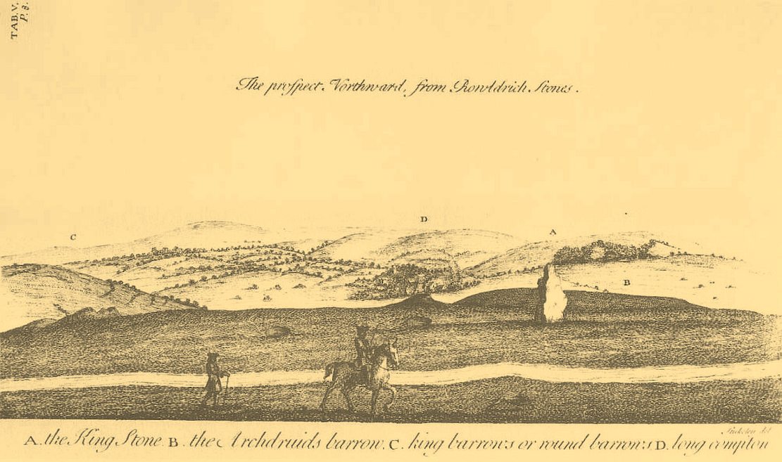
Stukeley’s 1743 sketch showing the King Stone
Arriving around dawn, Robins took several background readings along some of the lanes a mile or so away and found the usual expected background levels (on a scale of 1-10, the background flickers between 0 and 1). When he eventually walked into the Rollright stone circle with his ultrasound monitor, no undue perturbations were found. He spent thirty minutes here, but at no time did he record anything other than background readings. So he crossed the road and tried the same at the King Stone—where a big surprise awaited him.
Switching on the detector he found an anomalously high reading, beating every minute or so, not unlike a heartbeat, more than five times above the background ultrasound!
“This was really peculiar,” he wrote, “in that the pattern was spread over about a minute and then commenced again after about 10 seconds, endlessly repeated.” Robins spent some time here and found that the strange ‘pulse’ wasn’t solely confined to the King Stone, but spread some distance around the old standing stone and onto the road itself.
Investigation of potential radiation anomalies was another avenue of enquiry explored by the Dragon Project, and although thousands of hours of monitoring were done at the three focal sites, there were few anomalies to write home about. Two however, were recorded in March and August, 1981, when radiation levels were twice the normal background rate for short periods of just a few minutes each. More puzzling was the finding—which can still be verified today—of radiation levels three and four times above background on the road between the circle and the King Stone.
Next on the list was an attempt to monitor the Rollright stones with infrared devices. This proved to be a potential goldmine, as there was the chance of photographic imagery. So early one morning in April, 1979, Paul Devereux readied himself at the King Stone. He took a number of photos at five minute intervals either side of sunrise. This time of day was chosen because of the repeated anomalous ultrasound emissions from the King and it was thought that this, if any, would be the best time to capture something on film.
“When the first roll of black-and-white IR film was professionally developed,” he wrote, “I was astonished to see a curious ‘glow’ effect around the King stone on the frame taken at sunrise.” His first account of it appeared in The Ley Hunter, where he described how “a hazy glow can be seen clinging to the sides and upper parts of the megalith. This glow becomes much stronger at the top of the stone where it looks like a cap of light.” Although the sun had risen, it was off to the left of picture and apparently no satisfactory explanation can be given to the effect on the plate. Research physicist Simon Hasler—who worked for Kodak—closely studied the negatives of this image and found the evidence for a simple explanation “weak.” A possible explanation of the mysterious glow was propounded by Don Robins, who suggested that an emission of microwaves from the stone may have been responsible, and although this sounds promising it has yet to be proven.
Folklore
(photo by Sir Wilson III)
Amidst the mass of modern lore, dowsed energy lines exceed here — although to be honest, most of them are little more than bullshit. Old school alignments in the form of leys that can be walked along are more credible, and one or two have been noted here. Dowser Laurence Main found a ley running between Broughton Church, “the old White Cross, the Victorian Cross and the old Bread Cross in Banbury. In the other direction the line led straight to the King Stone.” Although this line accurately links up these sites, other ‘ley points’ are utterly necessary between Broughton Church and the King Stone to give the alignment any real credibility. In a concise survey of the megalithic remains of this region made by Tom Wilson and myself, no other ley-points were found along the line.
In more traditional animist-based folklore, the creation myth here is well known. The famous, oft-repeated tale recites how a King and his men were marching across the land intent on conquering it when he came across an old hag, or witch near Rollright who offered the regal figure a magickal challenge. Some accounts name the witch as Mother Shipton—not the famous Yorkshire seer of the same name, but her less powerful (obviously!) southern counterpart. The old witch said to the King:
“Seven long strides thou shalt take, and
If Long Compton thou can’st see,
King of England thou shalt be.”
His majesty took this as a simple task and, with contempt, said to the old witch:
“Stick, stock, stone,
As King of England I shall be known.”
From where he was standing (which is never told, but presumed by most as the stone circle) the King then took seven long strides in the direction of Long Compton. As he was taking his seventh step the witch made the ground in front of him rise up, hence blocking his view of the village in the valley below. The old hag then said:
“As Long Compton thou canst not see,
King of England thou shalt not be.
Rise up, stick, and stand still, stone,
For King of England thou shalt be none;
Thou and thy men hoar stones shall be
And I myself an eldern tree.”
Thereupon, the King’s men who were waiting behind their master, the five knights in the field who were said to be conspiring against his majesty, and the King himself, were all turned into stone where they stood. The elder tree that the old witch turned herself into, was said to have grown along the old boundary close to the roadside, but this can no longer be verified. The folklorist Arthur Evans described several spots where the famed elder tree was said to have grown: one in the field close to the Whispering Knights, and another in the same field as the King Stone, close by another large stone that has long since gone.
When William Stukeley visited the area in the 18th century and heard about the legendary origin of these great monoliths, he told how “the country people for some miles round are very fond of, and take it very ill if anyone doubts it,” telling later, “The people who live at Chipping Norton and all the country round our first described temple of Rowldrich affirm most constantly, and as surely believe it, that the stones composing this work are a king, his nobles, and Commons turned into stones.
Another piece of animistic lore tells how the King Stone and the Whispering Knights venture, at midnight, less than half a mile south to drink from a spring in the small woodland at Little Rollright Spinney—although it is difficult to ascertain precisely which of the two springs the stones are supposed to visit. In some accounts, the stones reputedly drink from the well every night, but others tell that they only go there at certain times of the year, or on saint’s days. When Arthur Evans wrote of these tales he described there being a “gap in the bushes… through which they go down to the water,” but the terrain has altered since his day.
A variation of the same tale was told by T.H. Ravenhill, who wrote:
The old King c.1945
King Stone, c.1920
“The Lord of the Manor of Little Rollright desired to possess the King’s Stone in order to bridge Little Rollright brook. So he dug it up and tried to cart it away, but found that he had not enough horses. He hitched on more, and yet more, and still he found that he could not move the stone. Finally he succeeded and hauled the stone away to the Manor House. The same night he was alarmed by strange sounds about the house, which he attributed to the presence of the King’s Stone, and decided, therefore, to replace it on its mound. No sooner had he harnessed the first horse to the cart than it galloped away up hill with ease, taking with it the stone, which leapt to position on reaching its resting place.”
Evans also wrote about an eighty-year-old local woman who told that her mother visited the King Stone on Midsummer’s Eve, along with many other locals, when the elder was in full bloom and they would stand in a full circle around the tall monolith. Ritual of a sort was performed then the elder tree was cut and, as it bled, “the King moved his head.” This annual rite was said to partially disempower the witch of her magickal hold over the King when her blood trickled from the tree. Some locals believed that if but a pin-prick of the witch’s blood was drawn, she would lose her power for all eternity.
Beneath both the Rollright stone circle and the King Stone, legend reputes there to be such a cavern where the little people live. In some accounts they are said to dance around the old King.
Arthur Evans told how one local man, Will Hughes, actually saw the faerie dancing round the King.
“They were little folk like girls to look at,” he said.
Old postcard, c.1910
Sketch from 1904
Will’s widow, Betsy Hughes, told Evans that “when she was a girl and used to work in the hedgerows, she remembered a hole in the bank by the King Stone, from which it is said the fairies came out to dance at night. Many a time she and her playmates had placed a flat stone over the hole of an evening to keep the fairies in, but they always found it turned over next morning.” This curious entrance was a neolithic burial mound. Mark Turner described how the little people were “supposed to come out and dance around the stones by moonlight.”
As we have already seen, people used to take chippings off some of the old stones here—primarily the King—supposedly for luck, protection and good fortune. Local people used to blame Welsh workers more than anyone, but they wouldn’t be the only ones! Although those who took such chippings believed the pieces brought them luck, more often than not it was the opposite that happened. One local woman told Evans about her son who went to India as a soldier in the 19th century with a piece of the King Stone in his possession, but it did him no good whatsoever. He died of typhus! The Oxford archaeologist George Lambrick (1988) highlights in his book on the Rollright stones the extent of damage that has been done to the King Stone since 1607.
References:
Anonymous, The Rollright Stones: Theories and Legends, privately printed, n.d.
Bennett, Paul & Wilson, Tom, The Old Stones of Rollright and District, Cockley: London 1999.
Bloxham, Christine, Folklore of Oxfordshire, Tempus 2005.
Cowper, B.H., ‘Oxfordshire Legend in Stone,’ Notes & Queries (1st series), 7, January 15, 1853.
Devereux, Paul, ‘Is This the Image of the Earth Force?’ in The Ley Hunter 87, 1979.
Devereux, Paul, ‘Operation Merlin,’ in The Ley Hunter 88, 1980.
Devereux, Paul, ‘Operation Merlin 2,’ in The Ley Hunter 89, 1980.
Devereux, Paul, ‘The Third Merlin,’ in The Ley Hunter 92, 1981.
Devereux, Paul, Places of Power, Blandford: London 1990.
Devereux, Paul, The Sacred Place, Cassell: London 2000.
Evans, Arthur J., ‘The Rollright Stones,’ in Trans. Bristol & Glouc. Arch. Soc., 40, 1892.
Evans, Arthur J., ‘The Rollright Stones and their Folklore (3 parts),’ in Folklore Journal, 1895.
Lambrick, George, The Rollright Stones: The Archaeology and Folklore of the Stones and their Surroundings, Oxford Archaeology Review 1983. (Reprinted and updated in 1988.)
Michell, John, Megalithomania, Thames & Hudson: London 1982.
Pennick, Nigel & Devereux, Paul, Lines on the Landscape, Hale: London 1989.
Ravenhill, T.H., The Rollright Stones and the Men Who Erected Them, Little Rollright 1926.