Stone Circle (destroyed): OS Grid Reference – NY 88542 74175
Archaeology & History
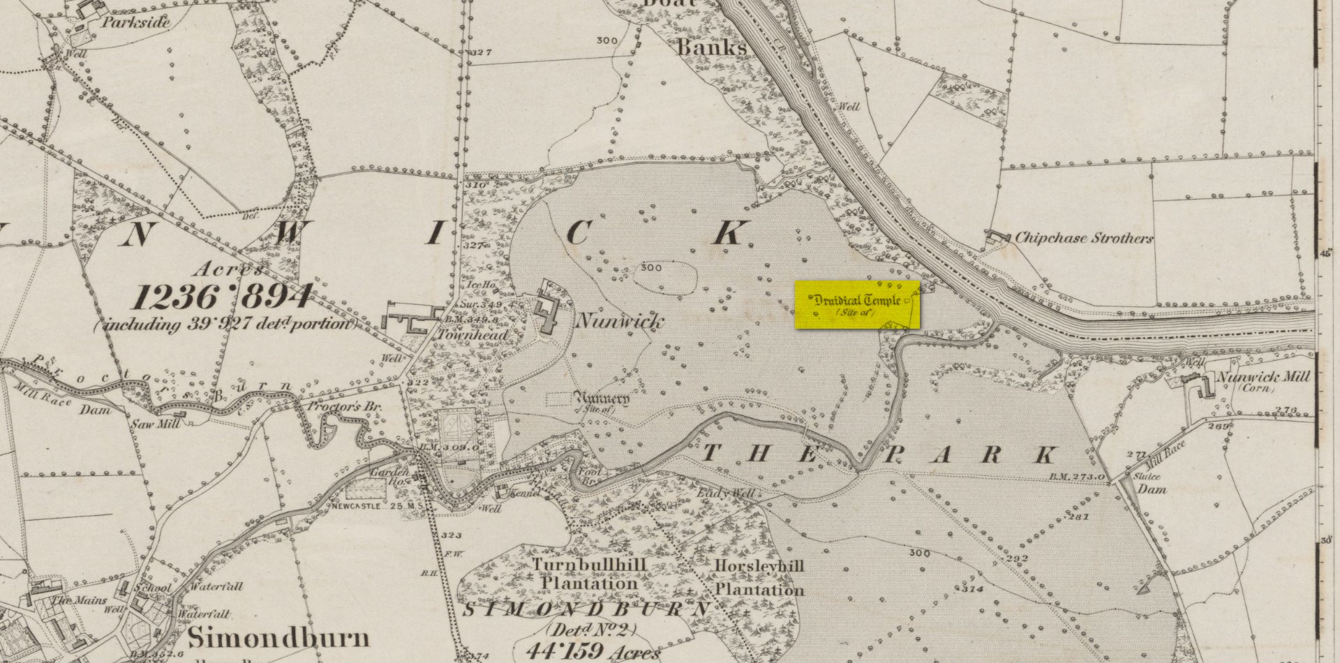
Site location on 1866 map
Highlighted, albeit in the past tense, as a “Druidical Temple” on the first Ordnance Survey map of the area in 1866, these megalithic remains were seen by earlier antiquarians, but seemingly met their demise sometime in the early 19th century. Some halfwit land-owners no doubt wanted their little garden extended to where local folk would have traditionally met at certain times each year—so in getting rid of the stones, it would help to keep the riff-raff away. (many of these elitists still think this way) It had certainly gone when the Northumbrian historian John Bates (1895) wrote about it, where he told simply:
“The fine circle at Nunwick, on North Tyne, described by Bishop Gibson, has long since disappeared.”
It was still standing in the 17th century, three or four thousand years after our ancestors put it there. We know this because the remains of the stone circle were told about in Gibson’s (1695) edition of Camden’s Britannia, where mention is made of “large stones erected at several places” in Northumberland, including this place where,
“near Ninwick in the Parish of Simondburn, four such stand still erected, and a fifth lies fall’n to the ground.”
The situation hadn’t changed when John Wallis (1769) visited Nunwick. On his trip to these megaliths he told that,
“In an adjoining field, called, Nunwick-east-field, were five upright stone-pillars, in a circular order; four of them perfect and entire in 1714, the other broken; the perfect ones eight feet high, and nine feet and an half over; the circumference of the area in which they stood, ninety feet.”
It was obvisouly a decent-sized circle! The great megalithic archaeologists Barnatt (1989) and Burl (2000) included the site in their respective catalogues, but could add no further details apart from saying there was a drawing made of the stones sometime around 1715 which, apparently, is in volume 15 of the History of Northumberland. Has anyone got a copy…? 🙂
References:
Barnatt, John, Stone Circles of Britain– volume 2, BAR: Oxford 1989.
Bates, John C., The History of Northumberland, Elliot Stock: London 1895.
Burl, Aubrey, The Stone Circles of Britain, Ireland and Brittany, Yale University Press 2000.
Dodds, M.H. (ed.), A History of Northumberland – volume 15: Simonburn, Rothbury, Alwinton, etc, Andrew Reid: Newcastle-upon-Tyne, 1935.
Gibson, Edmund (ed.), Camden’s Britannia, F. Collins: London 1695.
Wallis, John, The Natural History and Antiquities of Northumberland – volume 2, W. & W. Strahan: London 1769.
Acknowledgements: Huge thanks for use of the Ordnance Survey map in this site profile, reproduced with the kind permission of the National Library of Scotland.
From Pitlochry town centre, walk down the A924 high street as if you’re going to the Blair Atholl Distillery, but just before it take the right-turn and go over the river, and just keeping walking along this road for a third-of-a-mile (0.5km) until your reach a small small on your left that swerves up the hill (there’s a little signpost here saying Cluny Path to Strathtay). Go up and across the main road, then just keeping walking up the dirt-track, which becomes a footpath, and heads further uphill into and through the woodland. Make a bittova daydream from the walk up here, making sure to keep to the path closest to the burn (stream) on your left. Eventually when it levels out, you’re very close. Just keep on the same track and, where it meets up with another, bear left and about 100 yards along, on a small rise in the trees on your right, you’ll see these old stones peeking out. Keep your wits about you!
Archaeology & History
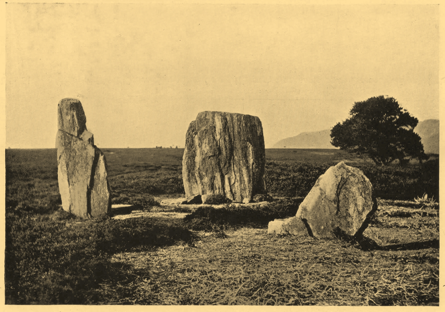
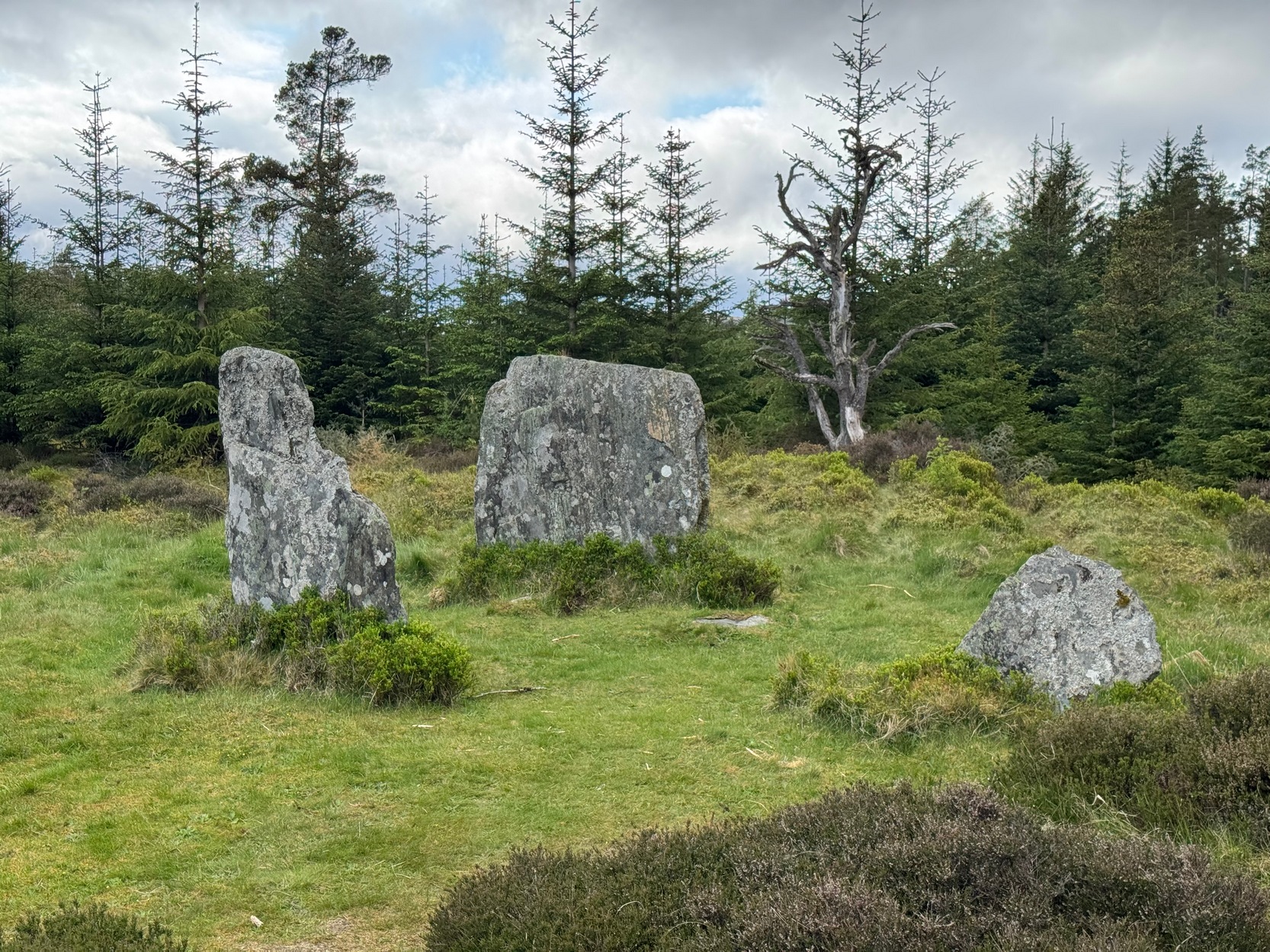
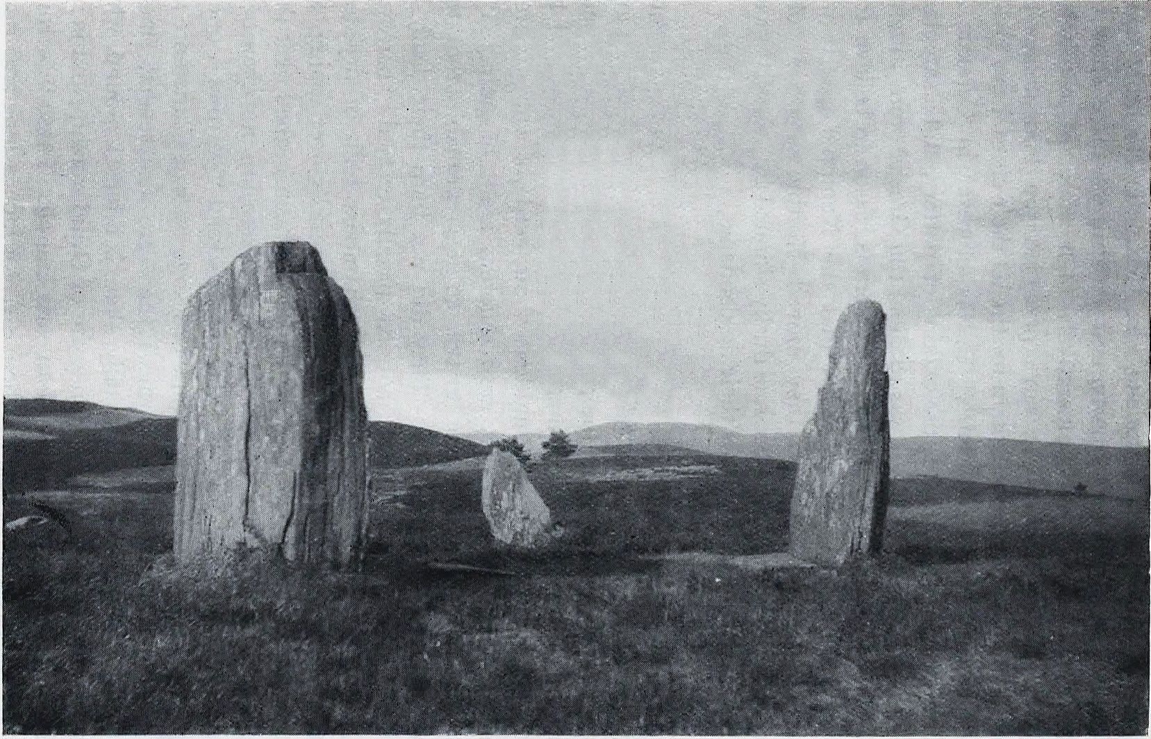
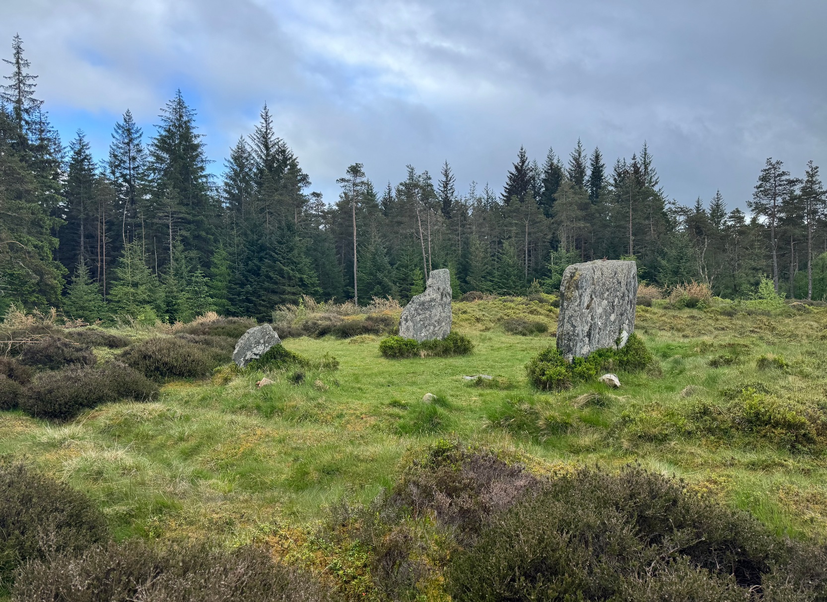
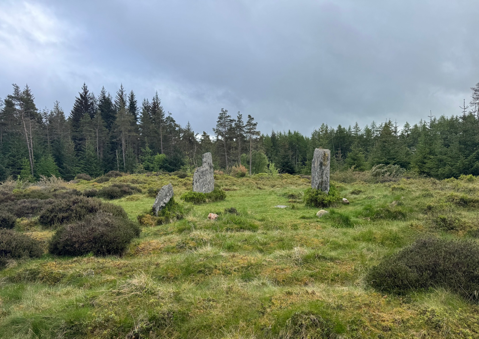
Clachan an Diridh looking E
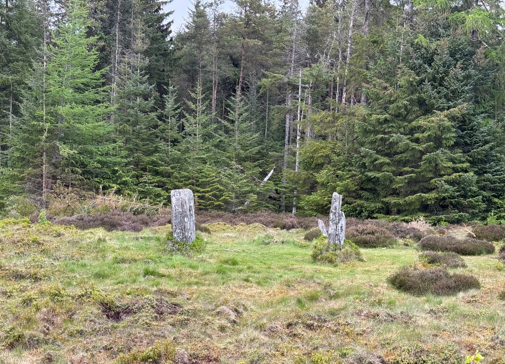
Sat high up on open moorlands with views all round… is what this site used to look like. Sadly, the forestry commission have almost completely enclosed this prehistoric site, making any view of the surrounding landscape all but impossible. I’m not the first and won’t be the last person to be pissed-off by such thoughtlessness. Alexander Thom made mention of it too. After making an initial assessment of the astronomical alignments at these stones in 1967, “when we returned to measure the horizon we found that trees had been planted round the stones and so we failed.” (Thom 1990) Not good.
On my first visit here, as I entered this “stone circle” my first impression was that it wasn’t a circle at all, but the remnants of a megalithic stone row! Thom thought the same. It’s the slender thin stature of the stones that do it to you: they almost cut the air and point the enquiring nose dead straight along the same angle that all the stones have been deliberately aligned to. I assume they’ve had a similar effect on other people over the years.
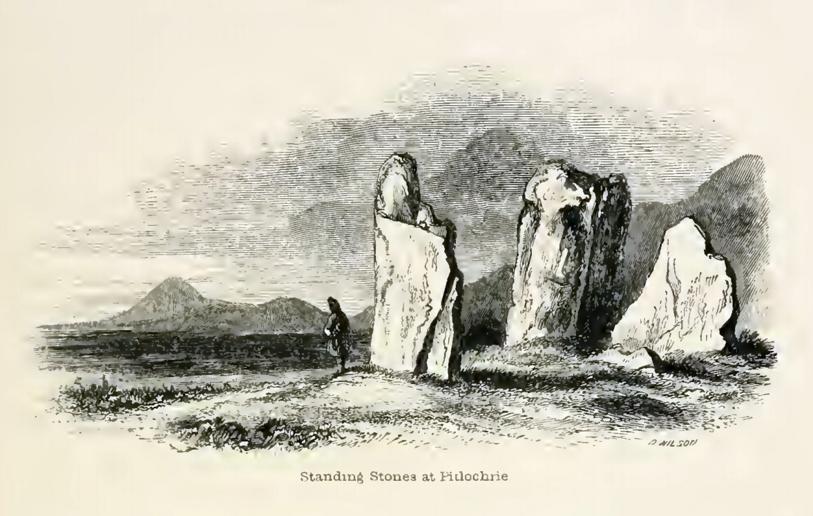
The Clachan an Diridh, or the Stones on the Ascent, were first mentioned in Dan Wilson’s (1851) major survey and who was so impressed by the view from here and its setting in the landscape that he compared its visage to Stonehenge. Were it not for the short-sightedness of the Forestry Commission destroying the view, most would no doubt agree with Wilson’s sentiments. From these olde stones, he told:
“One of the great level Highland moors stretches away beneath the eye, like a dark waveless lake, contrasting with the distant heights, among which Ben Lawers rears its pyramidal summit to an elevation of upwards of 4000 feet above the level of the sea. Amid this wild Highland landscape the huge standing stones, grey with the moss of ages, produce a singularly grand and imposing effect; and from the idea of lofty height which the distant mountains suggest, they convey a stronger impression of gigantic proportions than is produced even by the first sight of the giant monoliths of Salisbury Plain.”
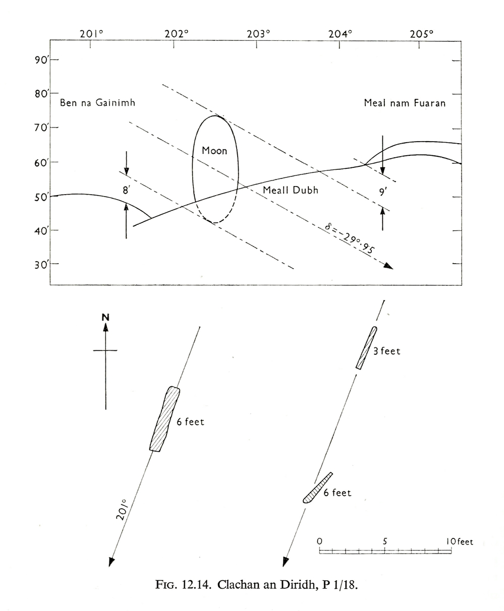
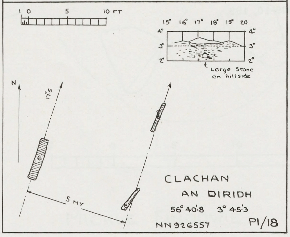
Thom’s initial moonset alignmentThom’s 1980 ground-plan with marker stone
The giant figure of Ben Lawers, if we could see it today, would rise to the southwest 20 miles (32km) from here; and the great pyramidal fairy mountain of Schiehallion would be equinox west, 13 miles (21km) away. Yet curiously when Alexander Thom surveyed the outlying hills, he didn’t think either of these mountains had any worth, astronomically speaking that is. Yet Lawers in particular would be the largest point on the southwestern horizon, rising in the distance, way beyond the wide rolling U-shaped glen of Strathtay to where the landscape changes into more rugged dynamic uplands. And the importance of Lawers as a place in prehistory is shown by the mass of petroglyphs across its slopes—particularly the side you could see from Clachan an Diridh.
Instead, Thom (1967) looked much further to the southwest—south-southwest in fact—where he initially thought that there was an alignment to the major southern moonset ten miles away above the rugged hill of Meall Dubh, framed on either side by the mountain peaks of Meall nam Fuaran and Beinn na Gainimh. Aubrey Burl (1988) told how Thom later discounted this alignment and instead turned his attention a full 180° where a large stone on the hillside to the north-northeast caught his theodolytic eye. This marked an alignment towards the peak of Ben Vrackie:
“There is little doubt,” he wrote, “that this is a lunar site showing perhaps…at the major standstill. Could one side of the southern 6ft high stone possibly have indicated the setting point of the Moon at minor standstill?” (Thom 1990)
Clachan an Diridh in 1851Clachan an Diridh, c.1920
Thom looked at these stones and the landscape with the mind of an astronomer, whereas I’m more in preference of the aborigine who sees the feel of the landscape to discern relationships and meanings. Sometimes, of course, the sky and the landscape come together and that universal mythic union of heaven and Earth finds importance at a site. I have little doubt that such a mythos was once known here, on the moorland plateau, under the clear stars with the darkness reaching to speak with Lawers and other bones of landscape in the solid darkness of mountain silhouettes and fading horizons. Many a sleep at this site would have touched minds with Wonder…
Anyway, all that aside…
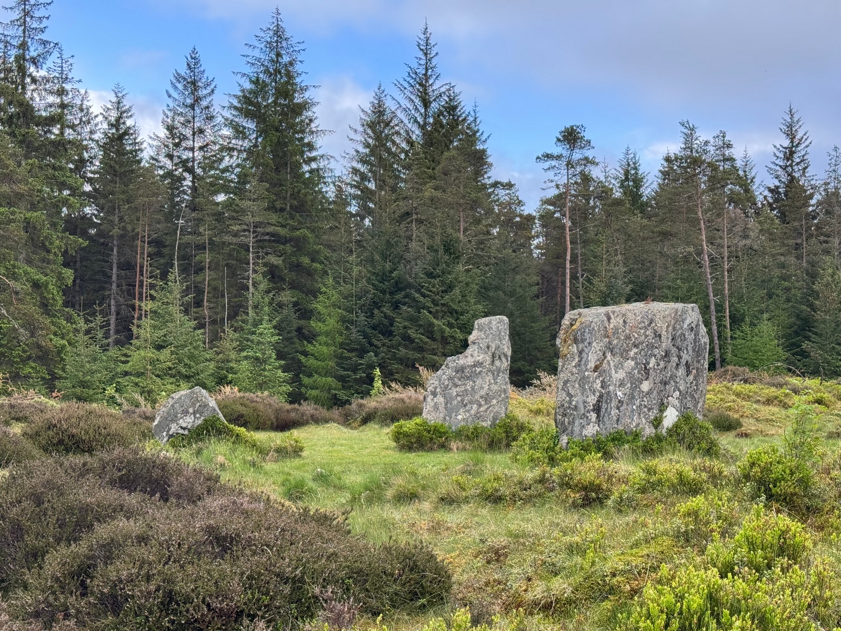
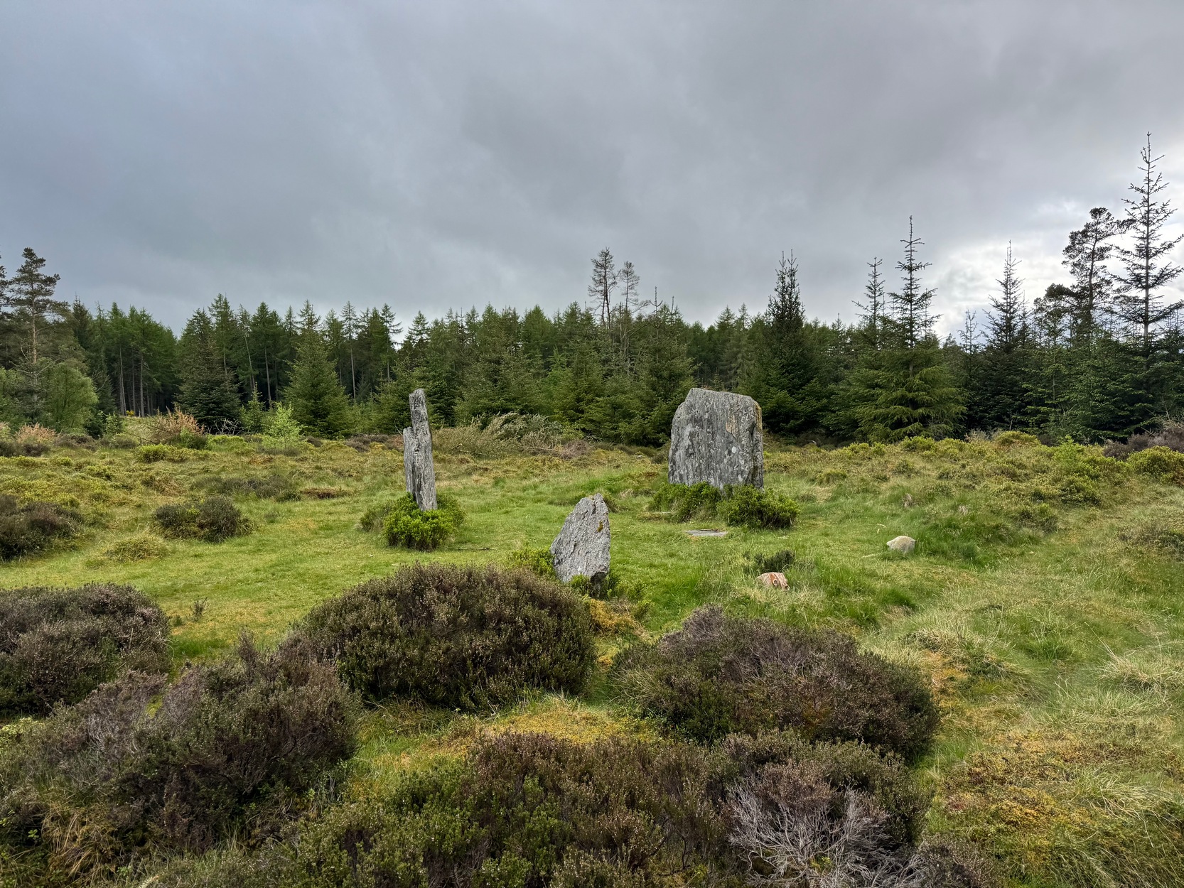
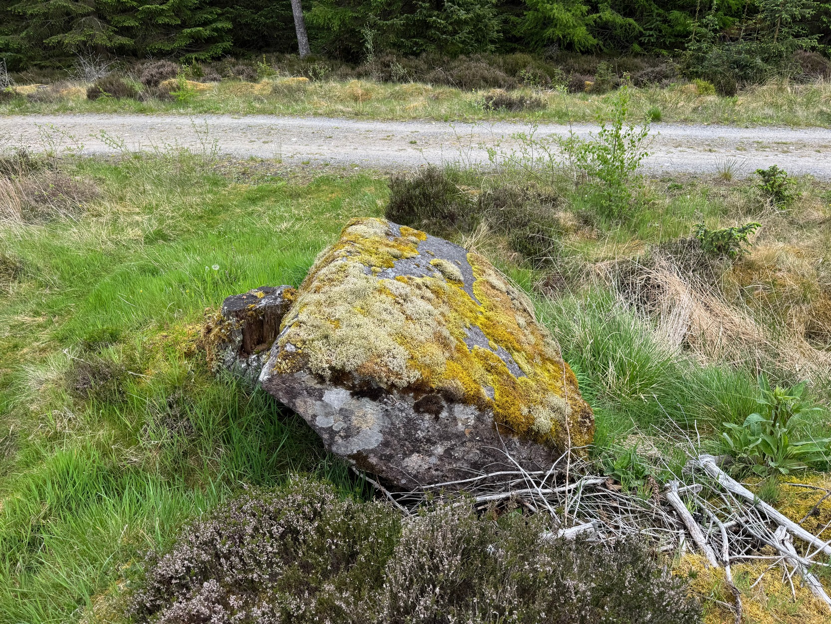
Large fallen stoneSite on the 1899 OS-map
These megaliths have been classified as one of Aubrey Burl’s “four posters”, i.e., a rough square of four megalithic uprights, in spite of there only being three standing stones here. Even when Dan Wilson (1851) wrote about the place there were just three of them. However, down the slope from the stones, just off the recent trackside, there’s a decent contender for the fourth stone lying on its side in the undergrowth, half-covered in moss. It’s certainly fallen or rolled down the slope and its size and shape suggest that it may once have stood upright. Have a thoughtful fondle of it while you’re here.
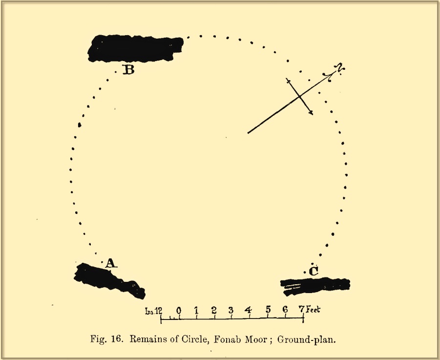
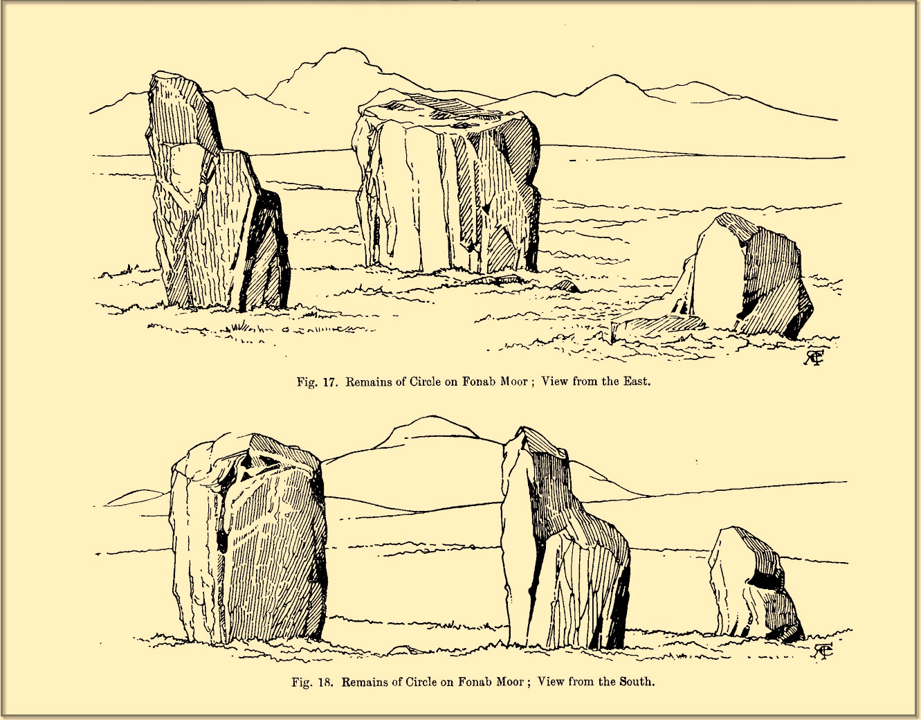
The ‘circle’ was highlighted on the 1899 OS-map and, a few years later, was visited and surveyed by the great Fred Coles (1908) and like Dan Wilson before him, told the view from here to be “very grand.” He continued:
Coles 1906 planColes’ views, from S & E
“In local parlance this group is known as the Four Stones. This must be a fairly old name handed down through some generations; because, for at least fifty-seven years past, only three Standing Stones have remained in situ. These three Stones are arranged as shown in the plan…in a group forming in its now imperfect condition a triangle which, measured from the centres of the Stones, has its SE side 11 feet 6 inches long; its SW side 12 feet 3 inches ; and its north side 16 feet 3 inches. Fragments of the demolished fourth Stone lie about the ground; but there is no clear indication of its original position. The South Stone, A, is 3 feet 7 inches in breadth, 5 feet 10 inches in height, and from 12 to 4 inches in thickness. The West Stone, B, 6 feet in height, measures 5 feet at the back, and 4 feet 10 inches at the front, and is 18 inches in thickness. The East Stone, C, at its outer angle is 3 feet 3 inches above ground, and leans inward. All the blocks are of quartziferous gritty sandstone, the East Stone being particularly rough and fissured. A large fragment lying near it seems to be a portion of it. The Stones are set upon a fairly true Circle with a diameter of 15 feet 4 inches. One feature quickly arrests notice: this is, that the broader faces of these Stones are not set even approximately upon and in line with the circumference, but nearly parallel with each other—an arrangement quite unlike the setting of Stones in the many other Circles hitherto surveyed.”
When Burl (1988) added this site to his Four Posters survey he merely echoed Coles’ early description, adding that, in his view, the standing stones that we see today were probably, originally, “set out on the circumference of a circle 20ft (6.1m) in diameter.”
I think it’s likely that there would have been more prehistoric sites in the vicinity, but a notable oddity is the almost complete absence of other recorded sites anywhere nearby. Of course, if there was anything, those thoughtful Forestry Commission heads would have destroyed it. We are left, simply, with the old but reliable notes of Messrs Dixon (1923) and Mitchell (1925) who told that, in their days, other remains did exist nearby in the form of ancient cairns and hut circles—‘Pictish’ according to tradition. If we’re lucky, some damaged parts of them might still be found at the edges, a short distance to the north west…
Folklore
In Hugh MacMillan’s (1901) gorgeous literary sojourn along Strathtay, he strayed somewhat from his otherwise historical notices by telling that here,
“on the highest part of the moorland…is a group of ‘clachan iobairt’, or stones of worship, where the Druids of old performed their mysterious rites, going round the circle of standing stones from east to west with the sun, or the ‘car deasal’, the lucky side, when they wished to invoke a blessing upon their friends, and going round the circle in the opposite direction, from west to east, the ‘car tuathsel’, or unlucky side, when they wished to pronounce a curse upon their foes.”
Whether this was what Hugh Mitchell (1923) meant when he referred to the traditions surrounding Clachan an Dirirdh we don’t know, but he echoed MacMillan’s account (though made no reference of his words), also adding that it was a site that “was visited on the first of May” or Beltane by some local people….
References:
Burl, Aubrey, Four Posters: Bronze Age Stone Circles of Western Europe, BAR 195: Oxford 1988.
Burl, Aubrey, A Guide to the Stone Circles of Britain, Ireland and Brittany, New Haven & London 1995.
Burl, Aubrey, The Stone Circles of Britain, Ireland and Brittany, Yale University Press 2000.
Dixon, John H., Pitlochry, Past and Present, L. Mackay: Pitlochry 1925.
Kennedy, James, Folklore and Reminiscences of Strathtay and Grandtully, Munro Press: Perth 1927.
Liddell, Colin, Pitlochry – Heritage of a Highland District, PKDL: Perth 1993.
MacMillan, Hugh, The Highland Tay: From its Source to Dunkeld, H. Virtue: London 1901.
Mitchell, Hugh, Pitlochry District: Its Topography, Archaeology and History, L. Mackay: Pitlochry 1923.
Omand, Donald (ed.), The Perthshire Book, Birlinn: Edinburgh 1999.
Stevenson, J., “Prehistory,” in Omand’s The Perthshire Book, Edinburgh 1999.
Thom, Alexander, Megalithic Sites in Britain, Oxford University Press 1967.
Thom, Alexander, Megalithic Lunar Observatories, Oxford University Press 1971.
Thom, A., Thom, A.S. & Burl, H.A.W., Megalithic Rings, BAR: Oxford 1980.
Thom, A., Thom, A.S. & Burl, Aubrey, Stone Rows and Standing Stones – volume 2, BAR: Oxford 1990.
Wilson, Daniel, The Archaeology and Prehistoric Annals of Scotland, Sutherland & Knox: Edinburgh 1851.
Acknowledgements: Huge thanks for use of the Ordnance Survey map in this site profile, reproduced with the kind permission of the National Library of Scotland.
Cup-and-Ring Stone (removed): OS Grid Reference – NZ 1475 6350
Archaeology & History
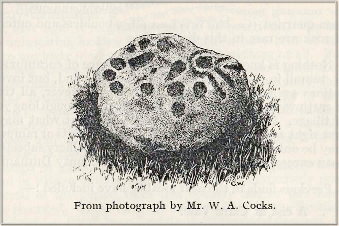
This carving presently lives in what Beckensall & Laurie (1998) described as “the stone store” at the Museum of Antiquities at the University of Newcastle-upon-Tyne, but it was discovered in some walling close to the road on the south-side of Ryton by a Mr William Cocks in 1934. The carved rock is relatively small—measuring “roughly two feet five inches, by one foot ten inches, by one foot three inches in thickness”—and was obviously not in its original position, but would have lived relatively close to the walling into which was placed. Mr Cocks told that,
1934 sketch of the carvingModified Beckensall sketch
“the stone bears one “cup and ring” with four radial ducts, the latter being in an exceedingly fine state of preservation. There are also ten plain cups of circular form; one cup with a deep conical duct; and one large cup which appears to have been formed by uniting two circular cups. All show the “pocking” or tool marks of manufacture, and these are especially noticeable in the radial ducts.”
The cup-marked Ryton (1) stone was found some 250 yards to the west and the Ryton (3) petroglyph was less than half-a-mile north, making it likely that other types of prehistoric remains once existed in this locale.
References:
Beckensall, Stan, Northumberland’s Prehistoric Rock Carvings – A Mystery Explained, Pendulum: Rothbury 1983.
Beckensall, Stan & Laurie, Tim, Prehistoric Rock Art of County Durham, Swaledale and Wensleydale, County Durham Books 1998.
Cocks, W.A., “The Ryton ‘Cup and Ring’ Marked Rock,” in Proceedings Society of Antiquaries Newcastle-upon-Tyne, volume 6, no.8, 1934.
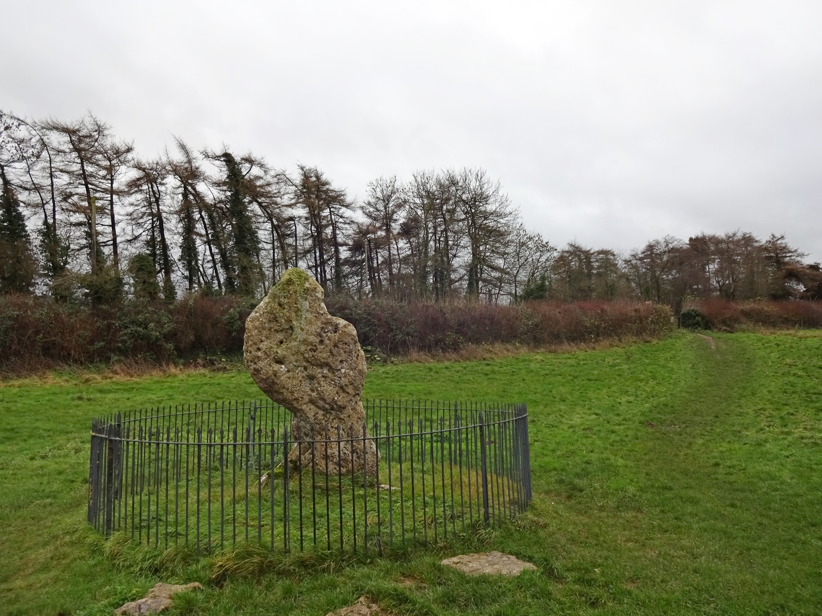
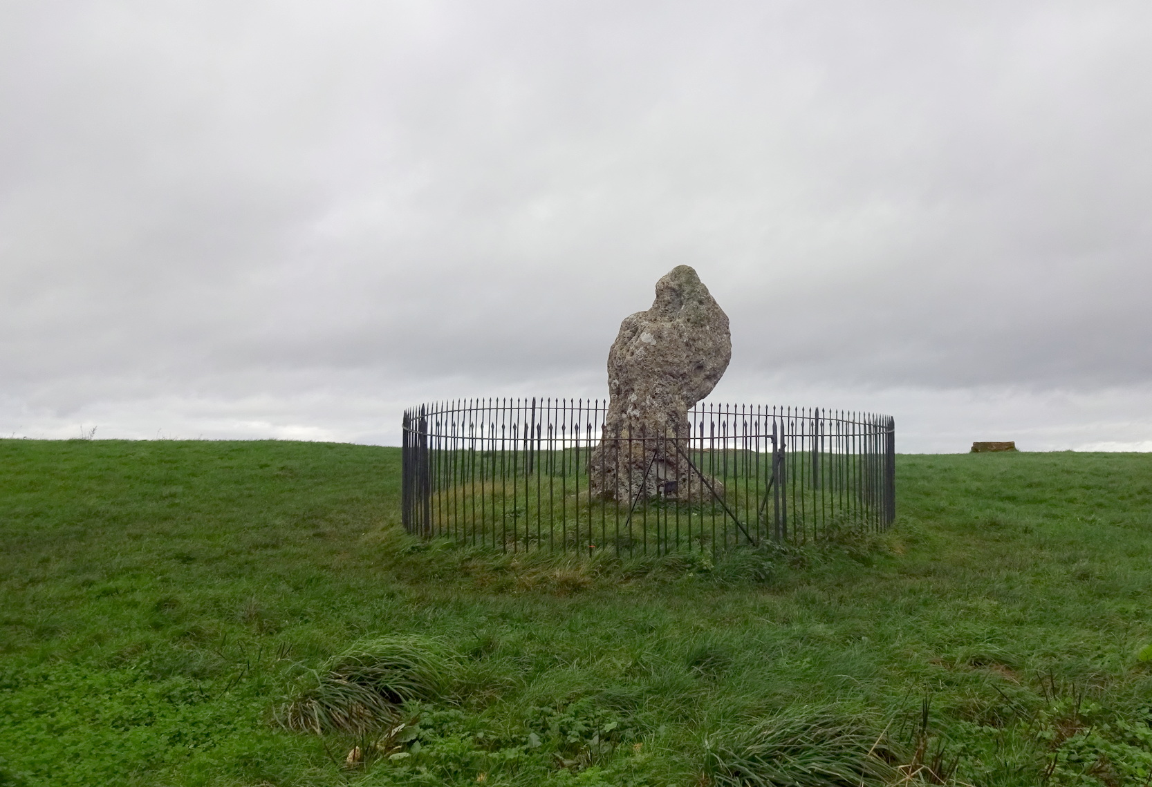
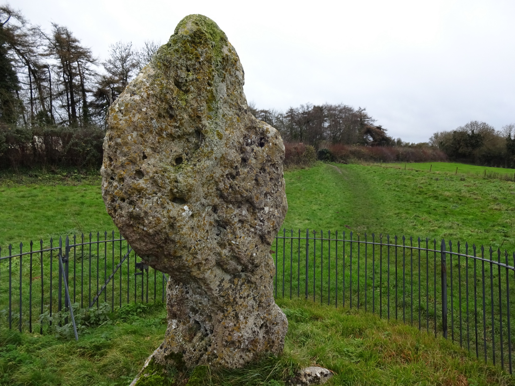
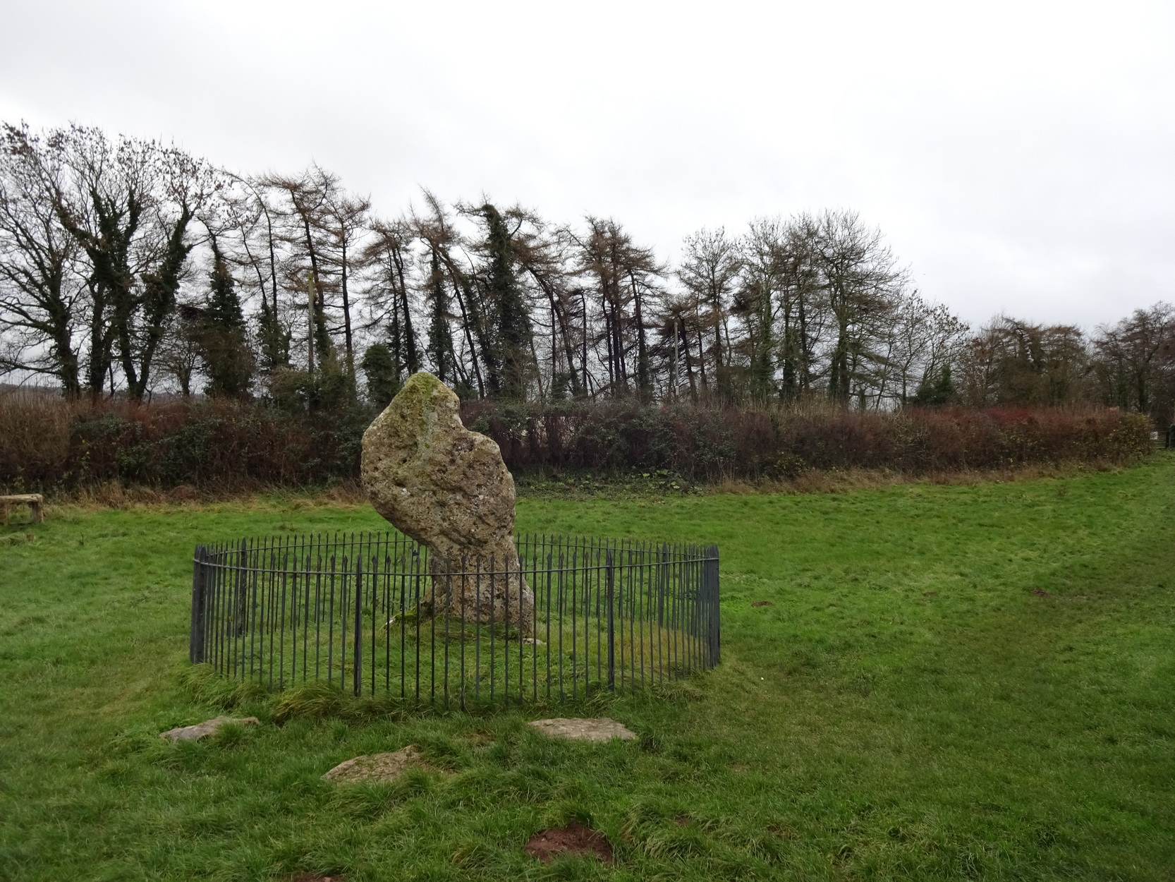
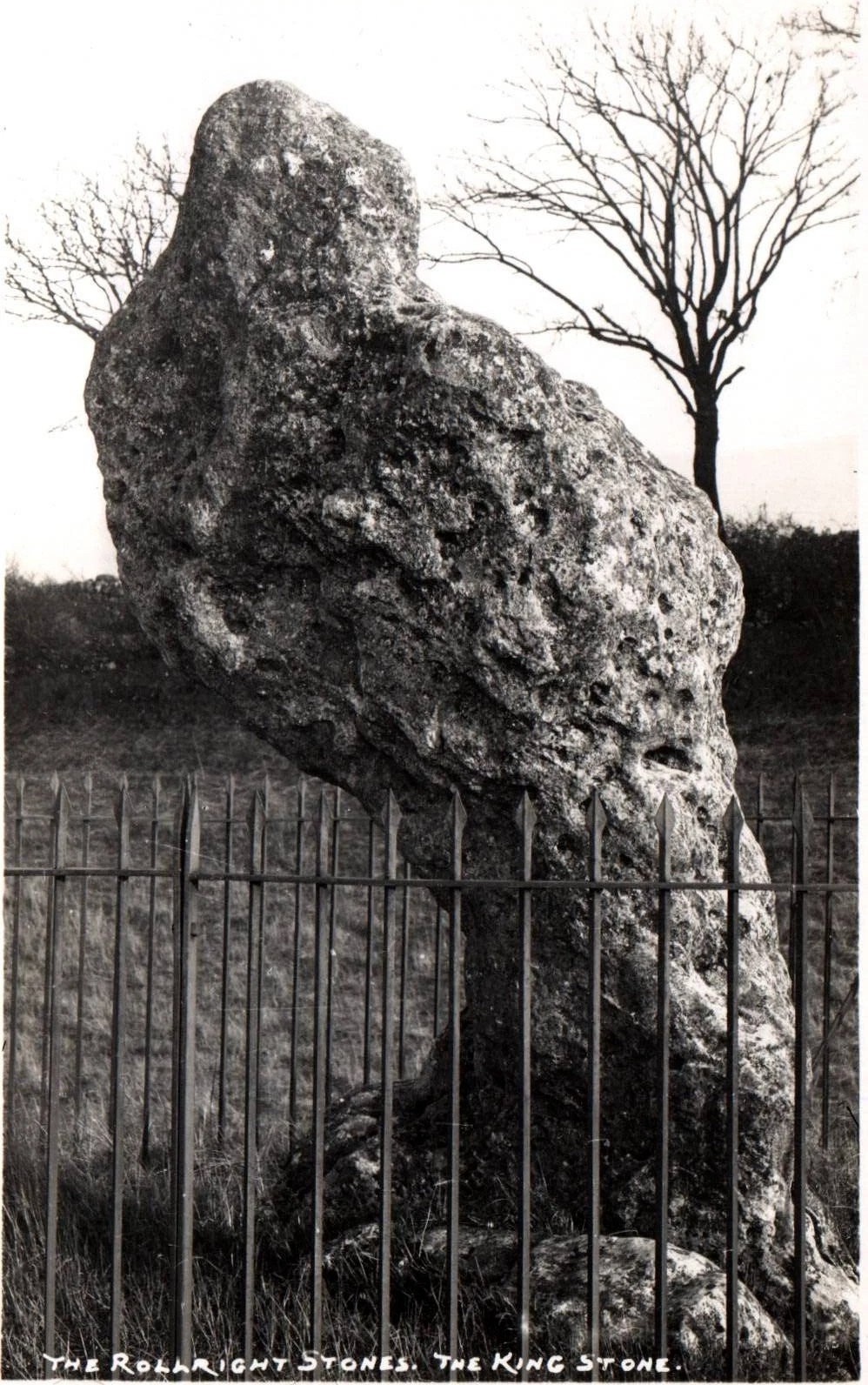
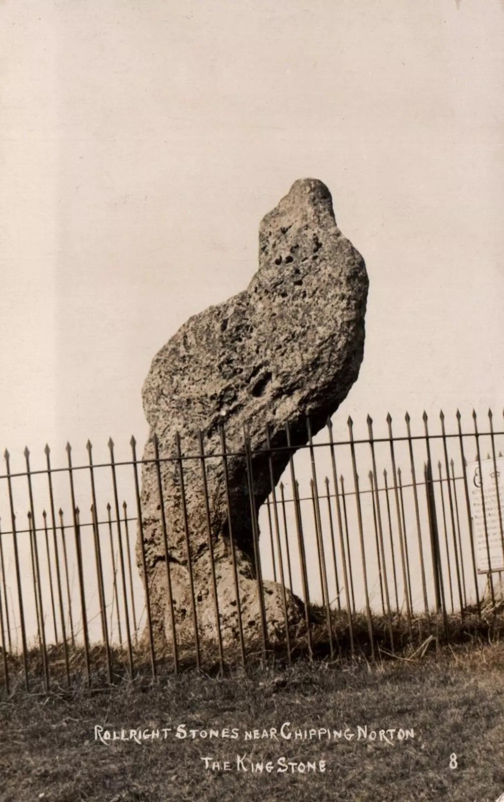
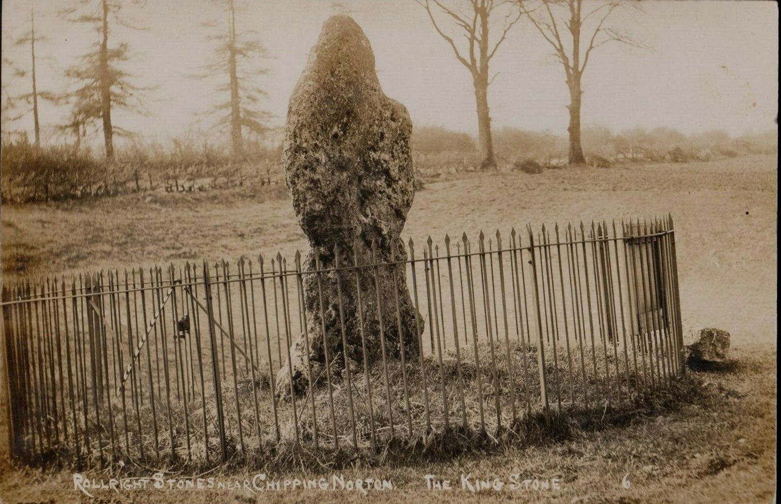
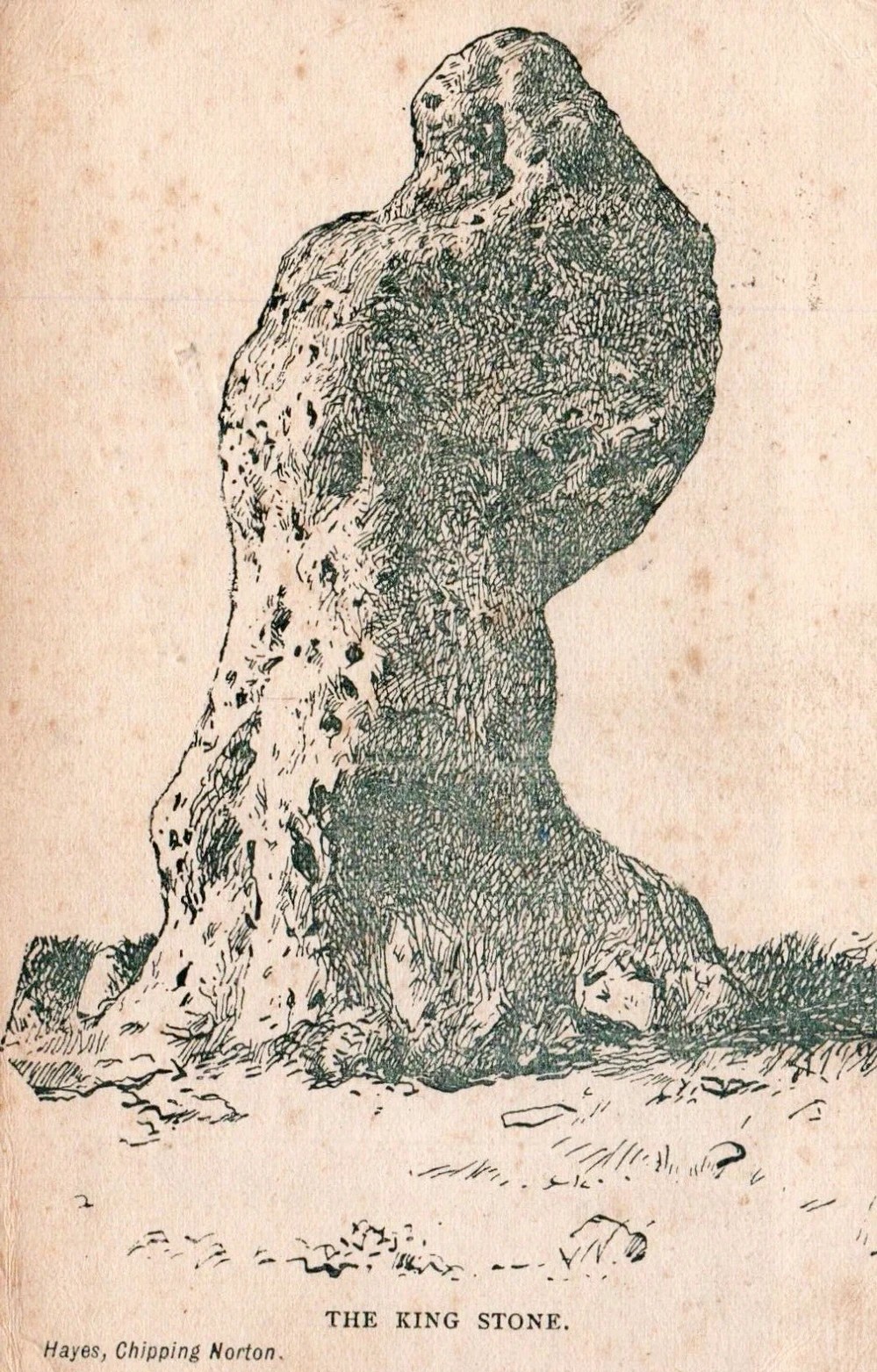
The King Stone of Rollright (photo by Sir Wilson III)
If you’ve reached the impressive Rollright Stone circle, simply cross the road, go through the gate and into the field, then up the gentle slope to your right. Y’ can’t miss it! If though, by any chance, you can’t find the Rollright Stones, get to Chipping Norton and ask a local!
Archaeology & History
An integral part of the Rollright Stones complex, this gnarled almost moth-eaten-looking standing stone, whose edges were cut away for medicinal properties in earlier centuries, still awakes each morning beside the small rise in the field, long thought to have been the remains of an ancient tomb — much to the archaeologist’s opinionated disdain in bygone years. Yet they had to swallow their pride…
This is an eight-foot-tall standing stone made from the same local oolitic limestone as the King’s Men and overlooks the village of Long Compton on the northern side of the ridge. It actually stands besides an artificial mound which has been identified as a Bronze Age cairn—known in times past as the ‘Archdruid’s Barrow’— and suggested by Lambrick to date from around 1800 BCE. More recently however, the world’s leading authority on stone circles, Professor Aubrey Burl, has given the King Stone a more probable construction date of 3000 BCE. The date is consistent with other Neolithic finds in the adjacent fields. This old standing stone has suffered much down the centuries, with bits of it being chipped away to such an extent that it has been reduced to the novel shape we see today.
Looking up at the King (photo by Sir Wilson III)The King in dance
A little-known but important piece of megalithic history took place here in the 1970s and ’80s. It centred around an idea to investigation so-called “mysterious events” that are commonly reported at standing stones—and the King Stone has its own CV when it comes to such things. Curious stories have been described by people from all walks of life. Down the years, a number of people have told me of feeling some strange and powerful ‘energy’ at these places and stories of such things have filled many volumes, along with being the subject of many a folktale. So one evening in November, 1977, the then editor of The Ley Hunter, Paul Devereux, convened a meeting where twenty people from differing backgrounds gathered. At this first meeting were people from a variety of professional backgrounds: archaeologists, dowsers, chemists, biochemists, biologists, electronic engineers, geochemists, geophysicists, zoologists—and ley hunters of course. It was time, they thought, to address this issue of anomalous energies at stone circles and other ritual sites.
After some discussion about what they should call their investigations, “the long association of the dragon with some kind of earth force made it a fitting symbol.” And so, the Dragon Project (DP) was born…
On the misty morning of Saturday, 24 October, 1978, research scientist Don Robins—in the company of his dog and young son—drove the hundred miles from London to the Rollright Stones armed with a simple ultrasound detector. He didn’t know what he would find there, and his scientific training told him there shouldn’t really be anything untoward.
King Stone, looking W (photo by Sir Wilson III)Stukeley’s 1743 sketch showing the King Stone
Arriving around dawn, Robins took several background readings along some of the lanes a mile or so away and found the usual expected background levels (on a scale of 1-10, the background flickers between 0 and 1). When he eventually walked into the Rollright stone circle with his ultrasound monitor, no undue perturbations were found. He spent thirty minutes here, but at no time did he record anything other than background readings. So he crossed the road and tried the same at the King Stone—where a big surprise awaited him.
Switching on the detector he found an anomalously high reading, beating every minute or so, not unlike a heartbeat, more than five times above the background ultrasound!
“This was really peculiar,” he wrote, “in that the pattern was spread over about a minute and then commenced again after about 10 seconds, endlessly repeated.” Robins spent some time here and found that the strange ‘pulse’ wasn’t solely confined to the King Stone, but spread some distance around the old standing stone and onto the road itself.
Investigation of potential radiation anomalies was another avenue of enquiry explored by the Dragon Project, and although thousands of hours of monitoring were done at the three focal sites, there were few anomalies to write home about. Two however, were recorded in March and August, 1981, when radiation levels were twice the normal background rate for short periods of just a few minutes each. More puzzling was the finding—which can still be verified today—of radiation levels three and four times above background on the road between the circle and the King Stone.
Next on the list was an attempt to monitor the Rollright stones with infrared devices. This proved to be a potential goldmine, as there was the chance of photographic imagery. So early one morning in April, 1979, Paul Devereux readied himself at the King Stone. He took a number of photos at five minute intervals either side of sunrise. This time of day was chosen because of the repeated anomalous ultrasound emissions from the King and it was thought that this, if any, would be the best time to capture something on film.
“When the first roll of black-and-white IR film was professionally developed,” he wrote, “I was astonished to see a curious ‘glow’ effect around the King stone on the frame taken at sunrise.” His first account of it appeared in The Ley Hunter, where he described how “a hazy glow can be seen clinging to the sides and upper parts of the megalith. This glow becomes much stronger at the top of the stone where it looks like a cap of light.” Although the sun had risen, it was off to the left of picture and apparently no satisfactory explanation can be given to the effect on the plate. Research physicist Simon Hasler—who worked for Kodak—closely studied the negatives of this image and found the evidence for a simple explanation “weak.” A possible explanation of the mysterious glow was propounded by Don Robins, who suggested that an emission of microwaves from the stone may have been responsible, and although this sounds promising it has yet to be proven.
Folklore
(photo by Sir Wilson III)
Amidst the mass of modern lore, dowsed energy lines exceed here — although to be honest, most of them are little more than bullshit. Old school alignments in the form of leys that can be walked along are more credible, and one or two have been noted here. Dowser Laurence Main found a ley running between Broughton Church, “the old White Cross, the Victorian Cross and the old Bread Cross in Banbury. In the other direction the line led straight to the King Stone.” Although this line accurately links up these sites, other ‘ley points’ are utterly necessary between Broughton Church and the King Stone to give the alignment any real credibility. In a concise survey of the megalithic remains of this region made by Tom Wilson and myself, no other ley-points were found along the line.
In more traditional animist-based folklore, the creation myth here is well known. The famous, oft-repeated tale recites how a King and his men were marching across the land intent on conquering it when he came across an old hag, or witch near Rollright who offered the regal figure a magickal challenge. Some accounts name the witch as Mother Shipton—not the famous Yorkshire seer of the same name, but her less powerful (obviously!) southern counterpart. The old witch said to the King:
“Seven long strides thou shalt take, and
If Long Compton thou can’st see,
King of England thou shalt be.”
His majesty took this as a simple task and, with contempt, said to the old witch:
“Stick, stock, stone,
As King of England I shall be known.”
From where he was standing (which is never told, but presumed by most as the stone circle) the King then took seven long strides in the direction of Long Compton. As he was taking his seventh step the witch made the ground in front of him rise up, hence blocking his view of the village in the valley below. The old hag then said:
“As Long Compton thou canst not see,
King of England thou shalt not be.
Rise up, stick, and stand still, stone,
For King of England thou shalt be none;
Thou and thy men hoar stones shall be
And I myself an eldern tree.”
Thereupon, the King’s men who were waiting behind their master, the five knights in the field who were said to be conspiring against his majesty, and the King himself, were all turned into stone where they stood. The elder tree that the old witch turned herself into, was said to have grown along the old boundary close to the roadside, but this can no longer be verified. The folklorist Arthur Evans described several spots where the famed elder tree was said to have grown: one in the field close to the Whispering Knights, and another in the same field as the King Stone, close by another large stone that has long since gone.
When William Stukeley visited the area in the 18th century and heard about the legendary origin of these great monoliths, he told how “the country people for some miles round are very fond of, and take it very ill if anyone doubts it,” telling later, “The people who live at Chipping Norton and all the country round our first described temple of Rowldrich affirm most constantly, and as surely believe it, that the stones composing this work are a king, his nobles, and Commons turned into stones.
Another piece of animistic lore tells how the King Stone and the Whispering Knights venture, at midnight, less than half a mile south to drink from a spring in the small woodland at Little Rollright Spinney—although it is difficult to ascertain precisely which of the two springs the stones are supposed to visit. In some accounts, the stones reputedly drink from the well every night, but others tell that they only go there at certain times of the year, or on saint’s days. When Arthur Evans wrote of these tales he described there being a “gap in the bushes… through which they go down to the water,” but the terrain has altered since his day.
A variation of the same tale was told by T.H. Ravenhill, who wrote:
The old King c.1945King Stone, c.1920
“The Lord of the Manor of Little Rollright desired to possess the King’s Stone in order to bridge Little Rollright brook. So he dug it up and tried to cart it away, but found that he had not enough horses. He hitched on more, and yet more, and still he found that he could not move the stone. Finally he succeeded and hauled the stone away to the Manor House. The same night he was alarmed by strange sounds about the house, which he attributed to the presence of the King’s Stone, and decided, therefore, to replace it on its mound. No sooner had he harnessed the first horse to the cart than it galloped away up hill with ease, taking with it the stone, which leapt to position on reaching its resting place.”
Evans also wrote about an eighty-year-old local woman who told that her mother visited the King Stone on Midsummer’s Eve, along with many other locals, when the elder was in full bloom and they would stand in a full circle around the tall monolith. Ritual of a sort was performed then the elder tree was cut and, as it bled, “the King moved his head.” This annual rite was said to partially disempower the witch of her magickal hold over the King when her blood trickled from the tree. Some locals believed that if but a pin-prick of the witch’s blood was drawn, she would lose her power for all eternity.
Beneath both the Rollright stone circle and the King Stone, legend reputes there to be such a cavern where the little people live. In some accounts they are said to dance around the old King.
Arthur Evans told how one local man, Will Hughes, actually saw the faerie dancing round the King.
“They were little folk like girls to look at,” he said.
Old postcard, c.1910Sketch from 1904
Will’s widow, Betsy Hughes, told Evans that “when she was a girl and used to work in the hedgerows, she remembered a hole in the bank by the King Stone, from which it is said the fairies came out to dance at night. Many a time she and her playmates had placed a flat stone over the hole of an evening to keep the fairies in, but they always found it turned over next morning.” This curious entrance was a neolithic burial mound. Mark Turner described how the little people were “supposed to come out and dance around the stones by moonlight.”
As we have already seen, people used to take chippings off some of the old stones here—primarily the King—supposedly for luck, protection and good fortune. Local people used to blame Welsh workers more than anyone, but they wouldn’t be the only ones! Although those who took such chippings believed the pieces brought them luck, more often than not it was the opposite that happened. One local woman told Evans about her son who went to India as a soldier in the 19th century with a piece of the King Stone in his possession, but it did him no good whatsoever. He died of typhus! The Oxford archaeologist George Lambrick (1988) highlights in his book on the Rollright stones the extent of damage that has been done to the King Stone since 1607.
References:
Anonymous, The Rollright Stones: Theories and Legends, privately printed, n.d.
Bennett, Paul & Wilson, Tom, The Old Stones of Rollright and District, Cockley: London 1999.
Bloxham, Christine, Folklore of Oxfordshire, Tempus 2005.
Cowper, B.H., ‘Oxfordshire Legend in Stone,’ Notes & Queries (1st series), 7, January 15, 1853.
Devereux, Paul, ‘Is This the Image of the Earth Force?’ in The Ley Hunter 87, 1979.
Devereux, Paul, ‘Operation Merlin,’ in The Ley Hunter 88, 1980.
Devereux, Paul, ‘Operation Merlin 2,’ in The Ley Hunter 89, 1980.
Devereux, Paul, ‘The Third Merlin,’ in The Ley Hunter 92, 1981.
Devereux, Paul, Places of Power, Blandford: London 1990.
Devereux, Paul, The Sacred Place, Cassell: London 2000.
Evans, Arthur J., ‘The Rollright Stones,’ in Trans. Bristol & Glouc. Arch. Soc., 40, 1892.
Evans, Arthur J., ‘The Rollright Stones and their Folklore (3 parts),’ in Folklore Journal, 1895.
Lambrick, George, The Rollright Stones: The Archaeology and Folklore of the Stones and their Surroundings, Oxford Archaeology Review 1983. (Reprinted and updated in 1988.)
Michell, John, Megalithomania, Thames & Hudson: London 1982.
Pennick, Nigel & Devereux, Paul, Lines on the Landscape, Hale: London 1989.
Ravenhill, T.H., The Rollright Stones and the Men Who Erected Them, Little Rollright 1926.
Take the same directions as if you’re visiting the impressive Tormain (1) carving. About ten yards before you reach it, just at the top of the hill itself, almost the first flat stone you come across is the one you’re after. You’ll find it easily enough.
Archaeology & History
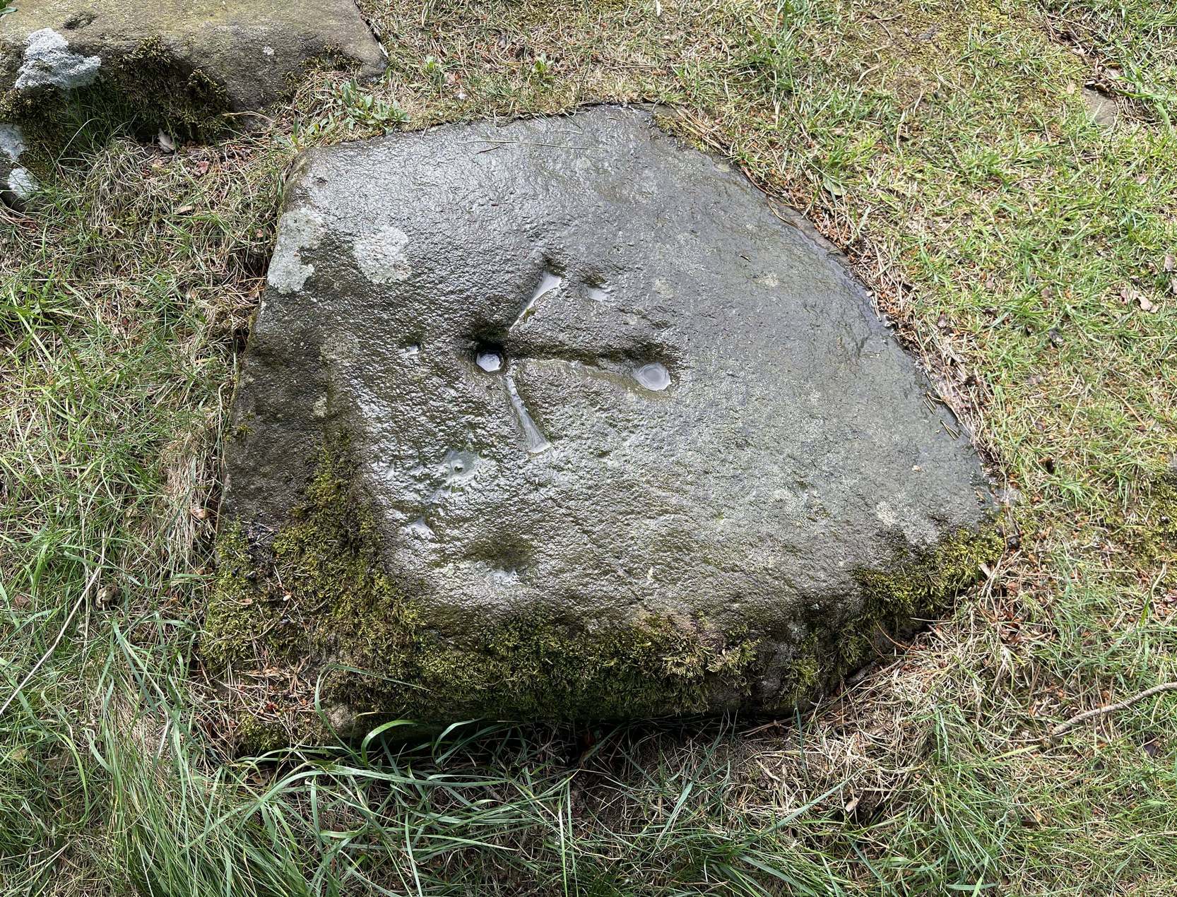
This is a notable design by virtue of the Ordnance survey lads marking it with an unusually large benchmark, utilizing at least one of the prehistoric cup-marks on their much more modern symbol. You can clearly see it in all the photos. The stone itself may have had a section of it cut or split from a once larger piece, probably in the 19th century when a lot of quarrying was being undertaken round here.
This carving was first described, albeit briefly, in John Smith’s (1874) piece on the nearby Witch’s Stone, where he told:
Allen’s 1882 sketch
“there is a group of three cup-like hollows near the highest summit of the hill; this last has, however, been altered in our own day by the officials of the Government Ordnance Survey combining them into one figure, by drawing from cup to cup their well-known and characteristic mark of the Queen’s ‘broad arrow.’”
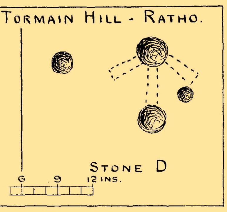
To be honest, there’s not much more that can be said of it. A few years later when Romilly Allen (1882) surveyed all the Tormain stones, he simply wrote that,
“Stone D…lies 30 feet from stone A, and is the most northerly of the group; it is also the highest as regards level, and has an Ordnance bench mark cut on it… Round the bench mark will be found four cups, varying in diameter from 1 to 2½ inches.”
Not all of the cup-marks on this stone are prehistoric, as is obvious when you look at them close-up. Two, perhaps three of them are OK, with at least one of those that are attached to the Ordnance Survey mark widened and deepened when they came here in the 19th century.
Morris, Ronald W.B., “The Cup-and-Ring and Similar Early Sculptures of Scotland; Part 2 – The Rest of Scotland except Kintyre,” in Transactions of the Ancient Monuments Society, volume 16, 1969.
Morris, Ronald W.B., The Prehistoric Rock Art of Southern Scotland, BAR: Oxford 1981.
Royal Commission Ancient & Historical Monuments of Scotland, Inventory of Monuments and Constructions in the Counties of Midlothian and West Lothian, HMSO: Edinburgh 1929.
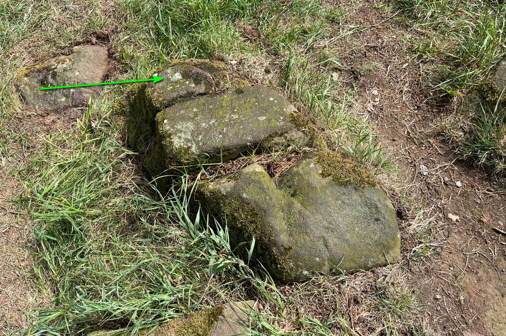
Two or three yards from the impressive Tormain (1) carving you’ll see this elongated stone, cracked into three separate pieces. Its sloping southeastern section is possessed of a single cup-marking, an inch or two across, which, if you found it anywhere else, you’d just shrug your shoulders and walk on by. It’s only due to this stones proximity to the more impressive carvings that it’s received any attention (ordinarily I wouldn’t even have added this to the database). It was first noticed when Romilly Allen (1882) visited the area. The Royal Commission’s (1929) survey of Tormain Hill mentioned “a single cup on one boulder,” but didn’t specify which of the three examples up here they were referring to.
Royal Commission Ancient & Historical Monuments of Scotland, Inventory of Monuments and Constructions in the Counties of Midlothian and West Lothian, HMSO: Edinburgh 1929.
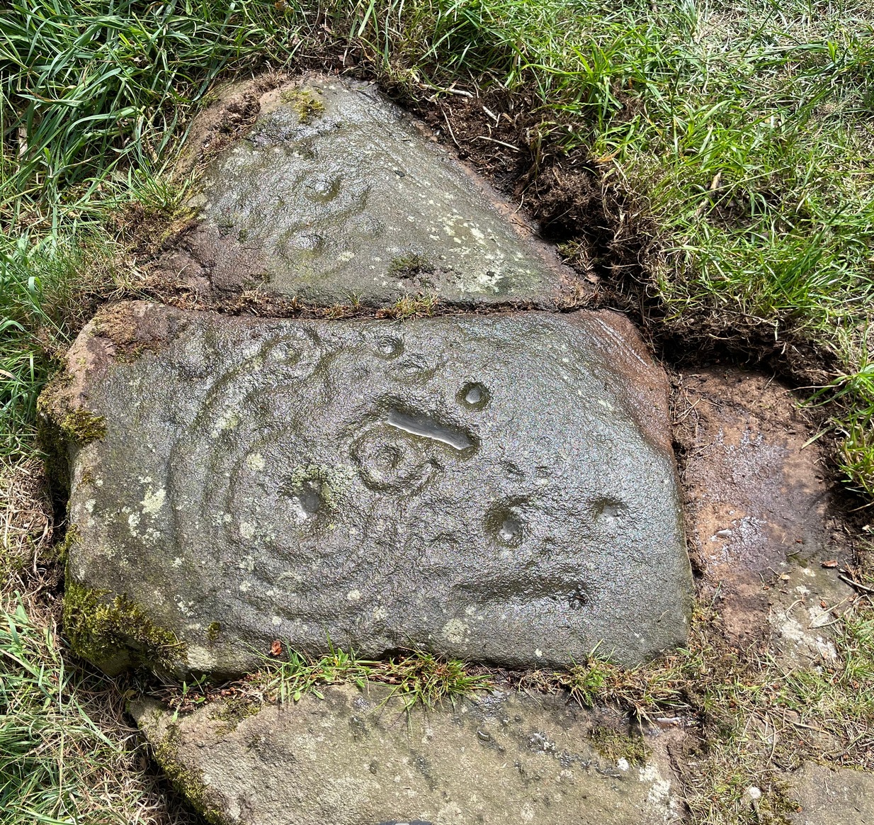
Best approached from Ratho village, head up Main Street towards Bonnington Mains. Shortly after the last road in the village (Halicroft Park, on the right) a small line of trees appears on the left and about 250 yards on a footpath takes you therein. Follow this for 250 yards (it runs parallel to the road) and the path then slopes uphill alongside the field. Go all the way to the top (roughly 500 yards) where the small copse of trees crowns the summit. On the ground there are a number of both small and medium-sized flat earthfast stones. You need to walk to the one at the end, just where the hill begins to slope back down. You’ll find it!
Archaeology & History
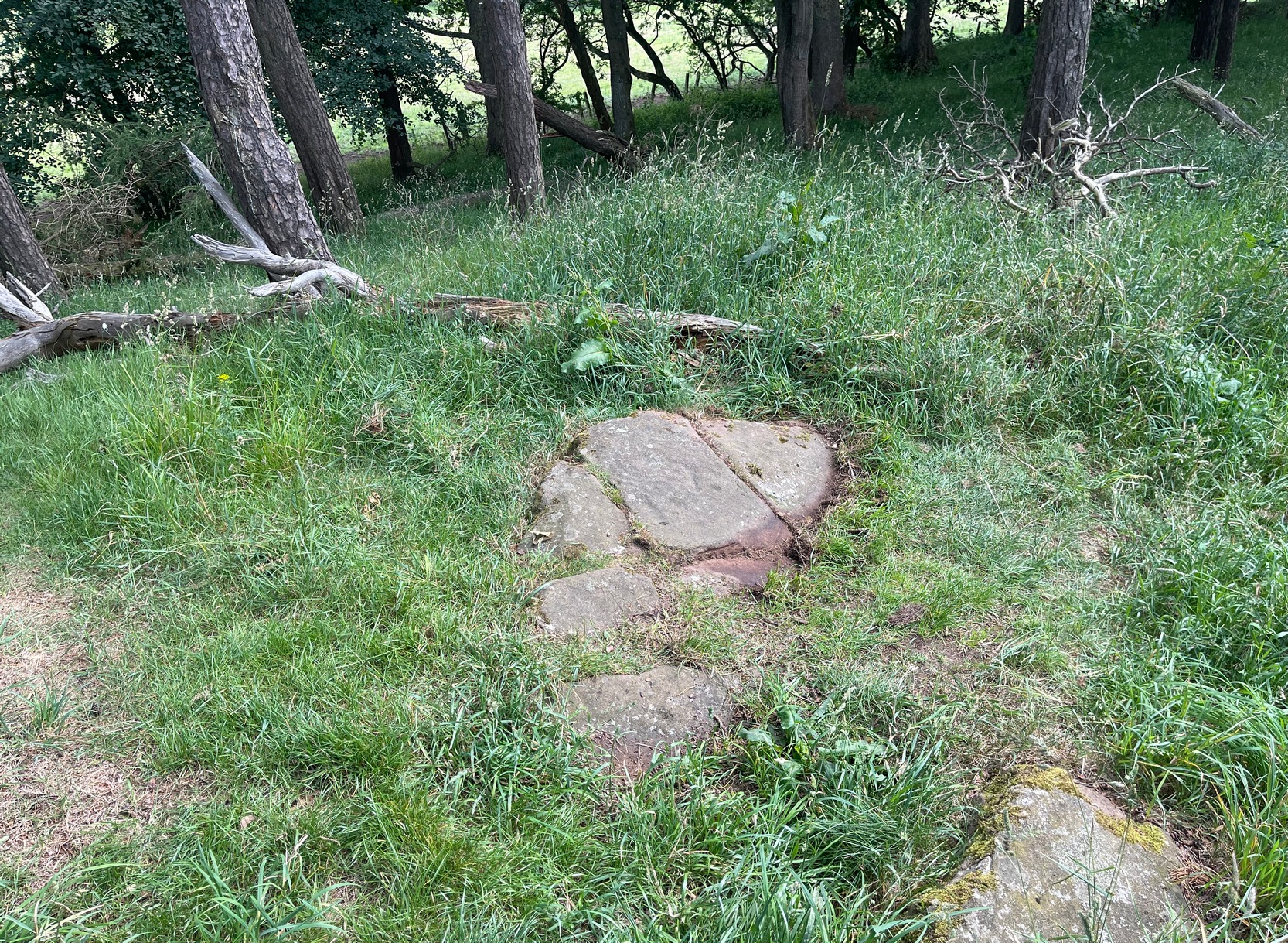
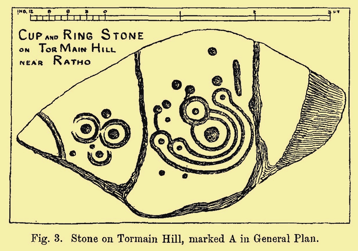
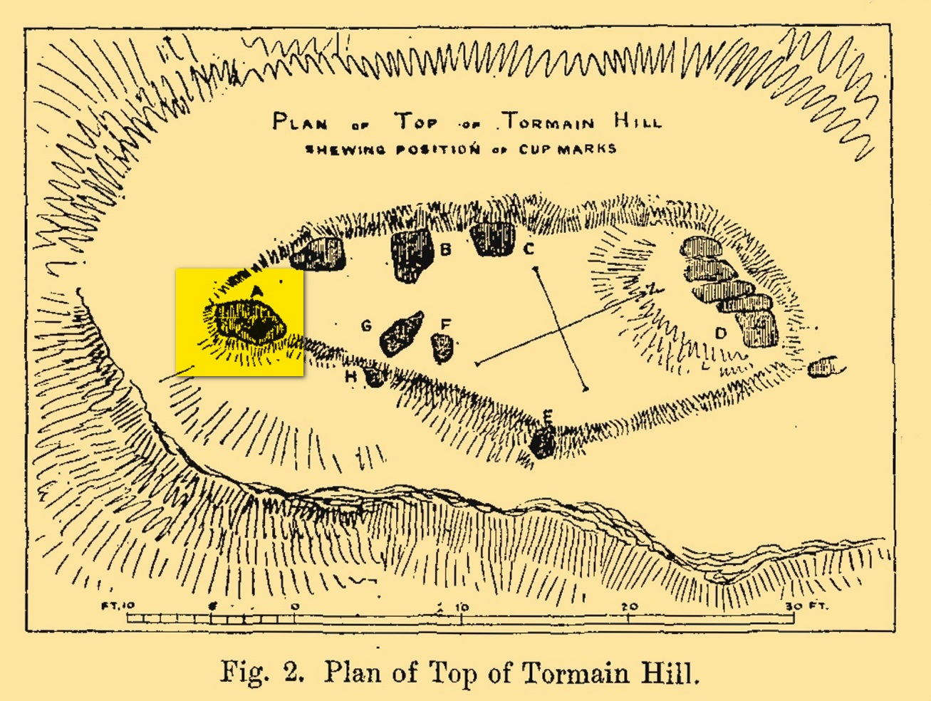
Tormain Hill, or the hill of stones (Harris 1996), has an interesting cluster of petroglyphs on its top, with this one in particular being the most impressive. It’s the southernmost stone in what’s been designated as a cluster of eight carvings—although we need to be slightly sceptical of one or two of them. Not this one though!
Regarded by Ron Morris (1981) as being “one of the best cup-and-ring designs in Scotland”, it was first mentioned by John Smith (1874) who visited the site with the local farmer James Melvin, who’d discovered the carving some years earlier. Initially he only noticed cup-markings, but when he visited the place with the pioneering rock art researcher Sir James Simpson, upon “removing the shallow soil or turf from the rock on the summit of Tormain Hill” this impressive multiple-ringed design came to light: “one cup (and) four concentric circles .”
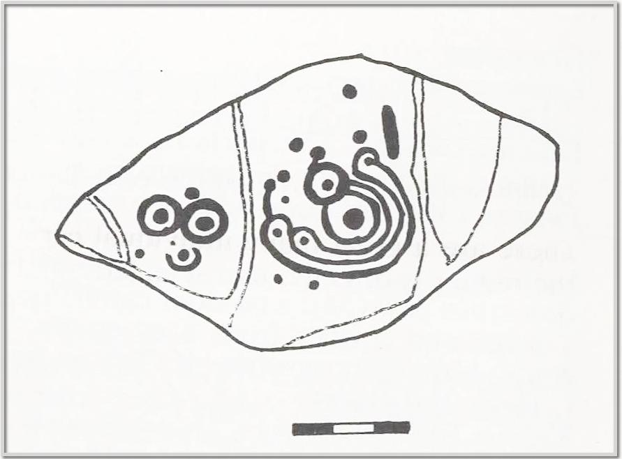
A few years later another rock art pioneer, J. Romilly Allen (1882) visited Tormain and found quite a bit more upon this hill. This particular carving, he told,
Allen’s 1882 sketchTormain ‘A’ site (Allen 1882)
“is much the finest and most remarkable in every way. It is the most southerly of the whole group, and is a piece of natural rock projecting from the side of the hill about 9 inches above the turf, and measures 4 feet 3 inches long by 2 feet 3 inches wide. Its upper surface is flat, of oval shape, and slopes slightly towards the hill. It is intersected by two parallel cracks of natural formation. The sculptures consist of twenty cups varying in diameter from three quarters of an inch to 2 inches in diameter. Seven of the cups are surrounded by a single ring, and one by four concentric circles. These latter are not complete, but form loops round terminal cups. Three of the cups with single rings are arranged in the form of a triangle. In addition to the cups and rings are two long grooves, one cutting off the corner of the stone, and the other parallel to one of the natural cracks.”
Beckensall’s 1986 version
More then forty years later the Royal Commission (1929) dudes visited the Tormain stones. It had become so overgrown by then that only two of the eight carved stones were visible: “but a search beneath the turf revealed the other sculpturings,” they told. It would seem that they chose a bit of a grey day when they came here as they told how the carving appeared “so much worn that the concentric rings are, in particular, difficult to follow.” So they did a rubbing of the stone—a common practice of rock art students over the last century or two. In doing so they were able to discern the following:
“The boulder is fractured in two places by natural agencies, but it shows traces of twenty cup-marks, varying from little more than half-an-inch to fully two inches in diameter, and there are two separate gutters. Seven at least of the cups are surrounded by single rings, and in two instances the rings are connected by shallow gutters to simple cup-marks. The largest cup-mark on the stone is encircled by one complete ring with three additional concentric arcs linking up four of the other rings. Another group consists of three cups, each surrounded by a ring, which are closely set in the form of a triangle, with three other smaller cup-marks in close proximity.”
Impressive stuff! In more recent times the site has gained the attention of fellow rock art explorers like Kaledon Naddair, Stan Beckensall and others—but we’re still none the wiser what it means!
Its position in the landscape was probably an important element. Pinus sylvestris (the ley-hunter’s favourite tree) grows spaciously, as it is wont, atop of the hill and, in bygone centuries, would have been much more prevalent before farming enveloped the land hereabouts. It was likely clear of trees on top of Tormain when the stone was carved, giving uninterrupted 360° views of the hills, high and low, as far as the eye can see. The legendary prehistoric Cairnpapple Hill stood out due west from the carving and other notable hilltops in the Pentlands would have had mythic relevance. Sadly, all oral tradition has long long faded and so whatever narratives that were told here have long ago been lost. It strikes me as a tribal gathering place: a moot hill perhaps. The bullaun stone adjacent to this fine carving would be a receptacle for paints, herbs, elixirs to be macerated and used by the people….
Check it out. Have a feel of the place. But spend a few hours here and listen to the wind…
Beckensall, Stan, Rock Carvings of Northern Britain, Shire: Princess Risborough 1986.
Beckensall, Stan, British Prehistoric Rock Art, Tempus: Stroud 1999.
Feachem, Richard, Guide to Prehistoric Scotland, Batsford 1977.
Hadingham Evan, Ancient Carvings in Britain: A Mystery, Garnstone: London 1974.
Harris, Stuart, The Place-Names of Edinburgh: Their Origins and History, Gordon Wright: Edinburgh 1996.
MacLean, Adam, The Standing Stones of the Lothians, Megalithic Research Publications: Edinburgh 1977.
Morris, Ronald W.B., “The Cup-and-Ring and Similar Early Sculptures of Scotland; Part 2 – The Rest of Scotland except Kintyre,” in Transactions of the Ancient Monuments Society, volume 16, 1969.
Morris, Ronald W.B., The Prehistoric Rock Art of Southern Scotland, BAR: Oxford 1981.
Royal Commission Ancient & Historical Monuments of Scotland, Inventory of Monuments and Constructions in the Counties of Midlothian and West Lothian, HMSO: Edinburgh 1929.
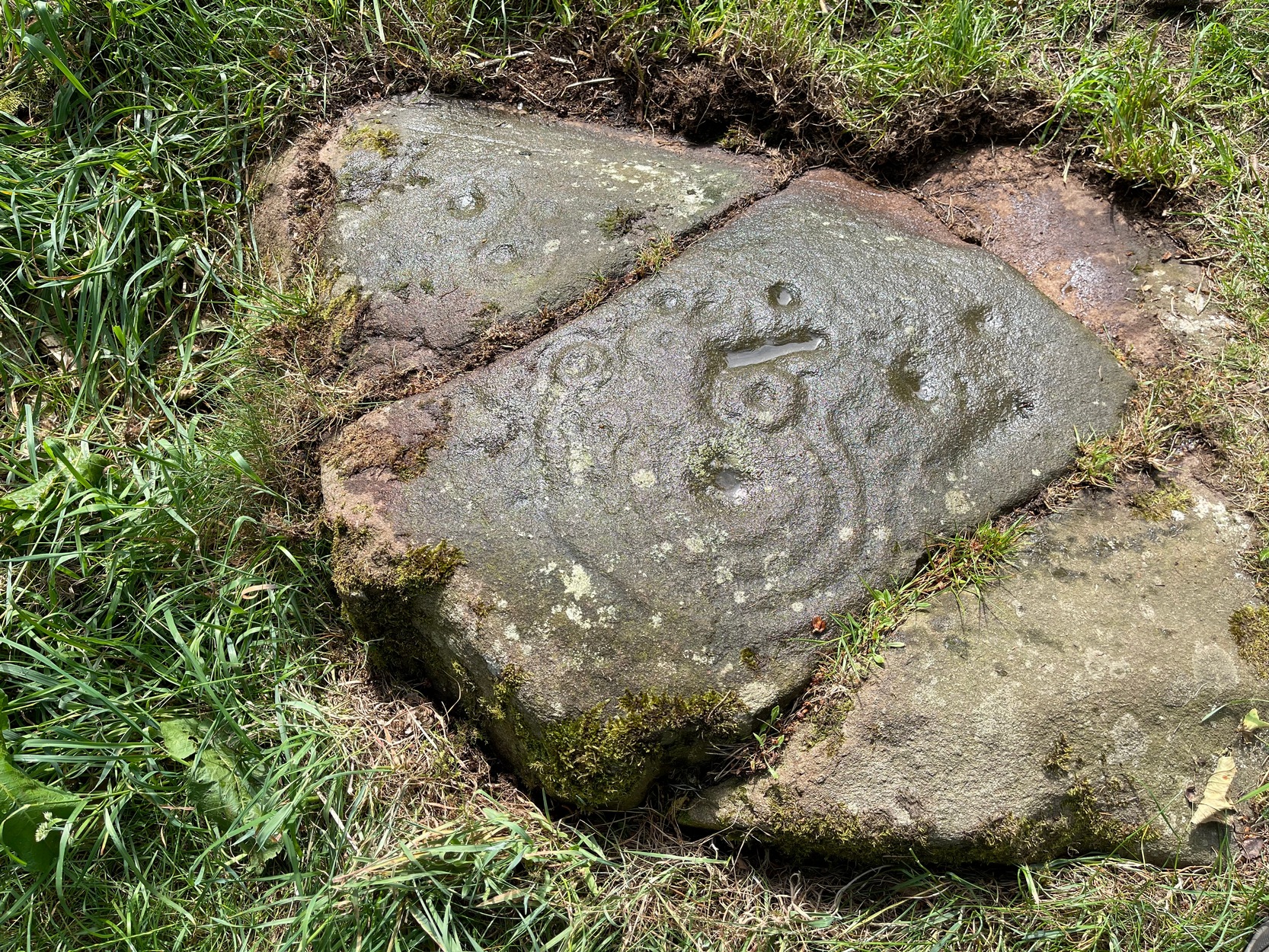
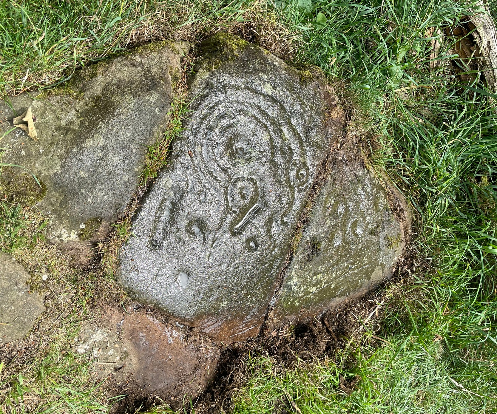
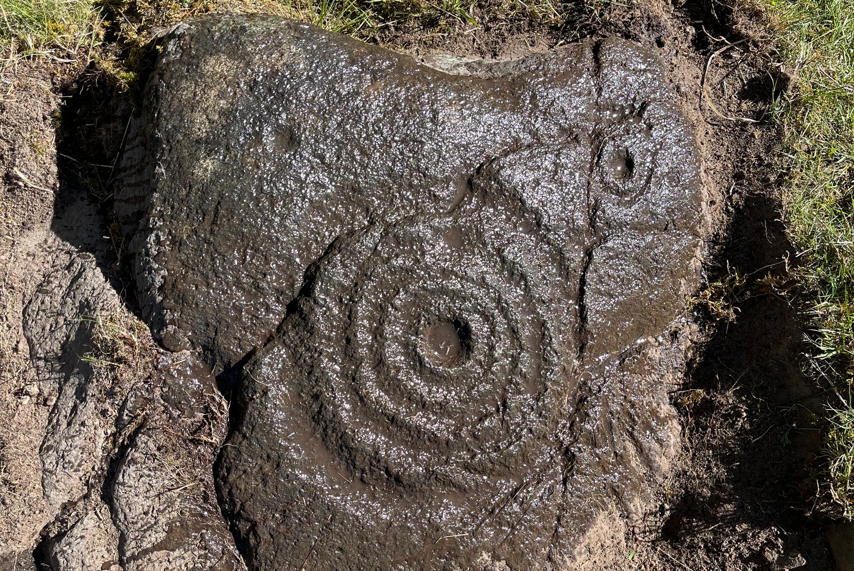
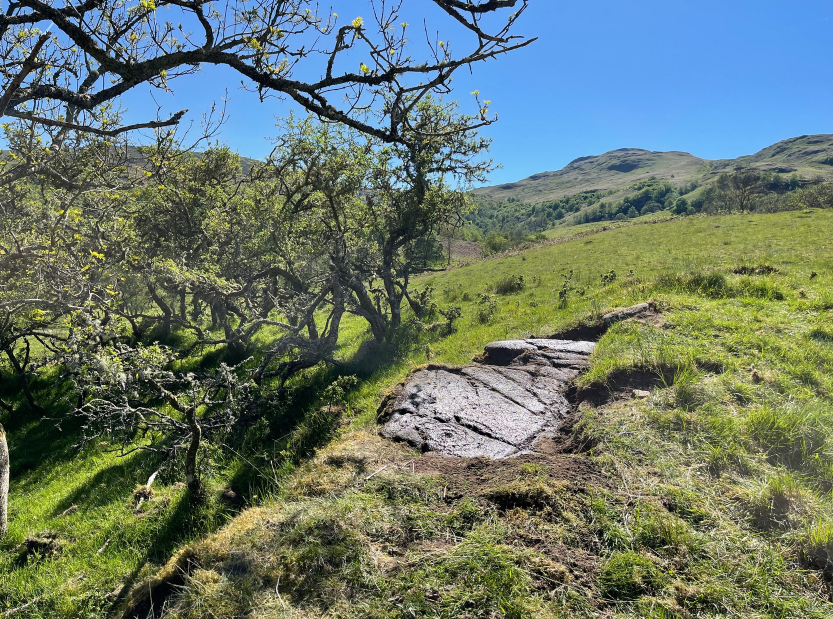
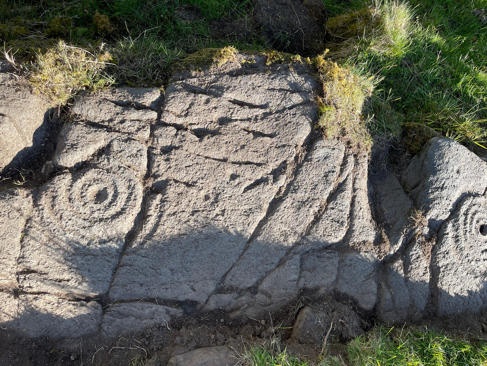
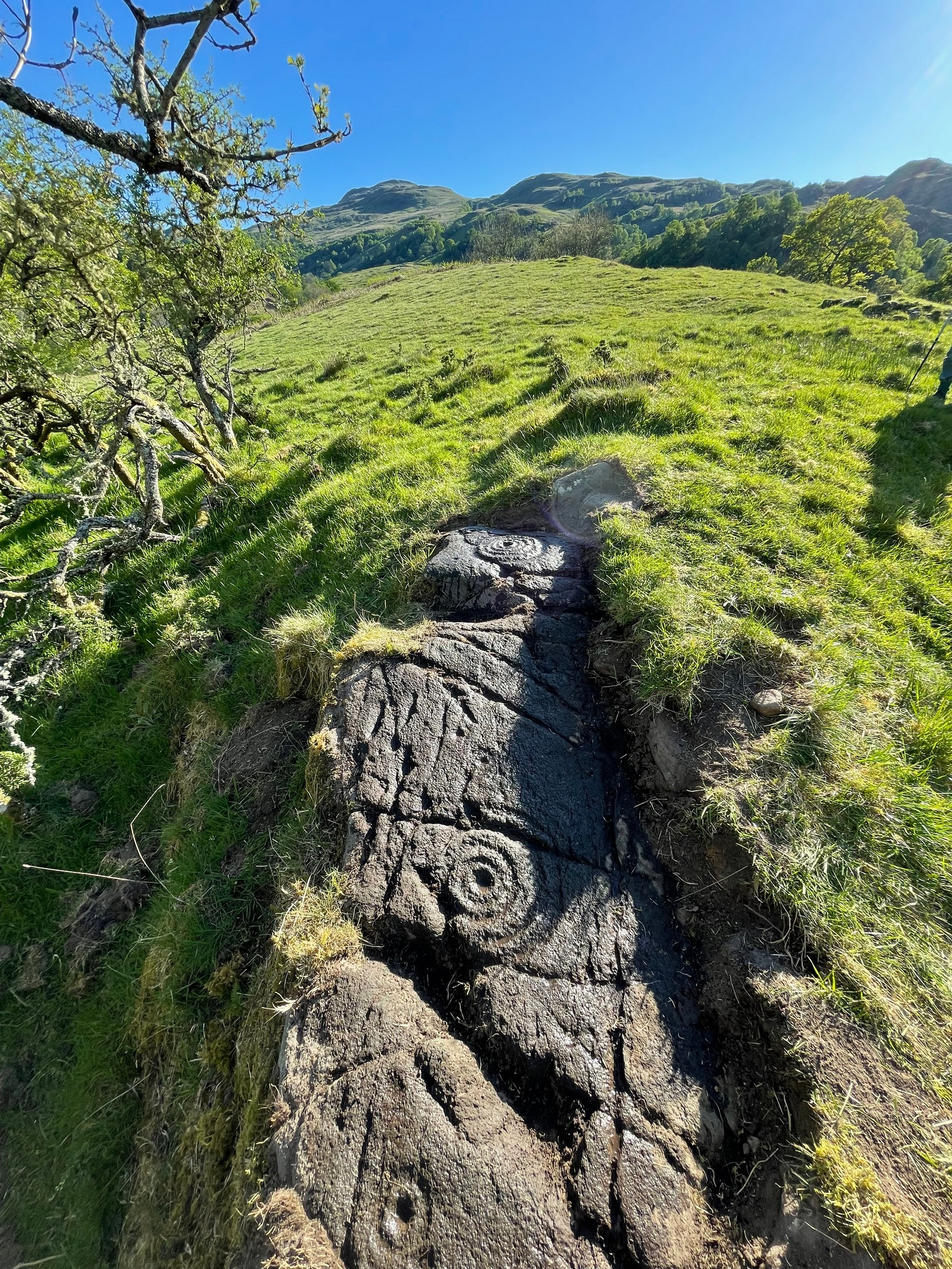
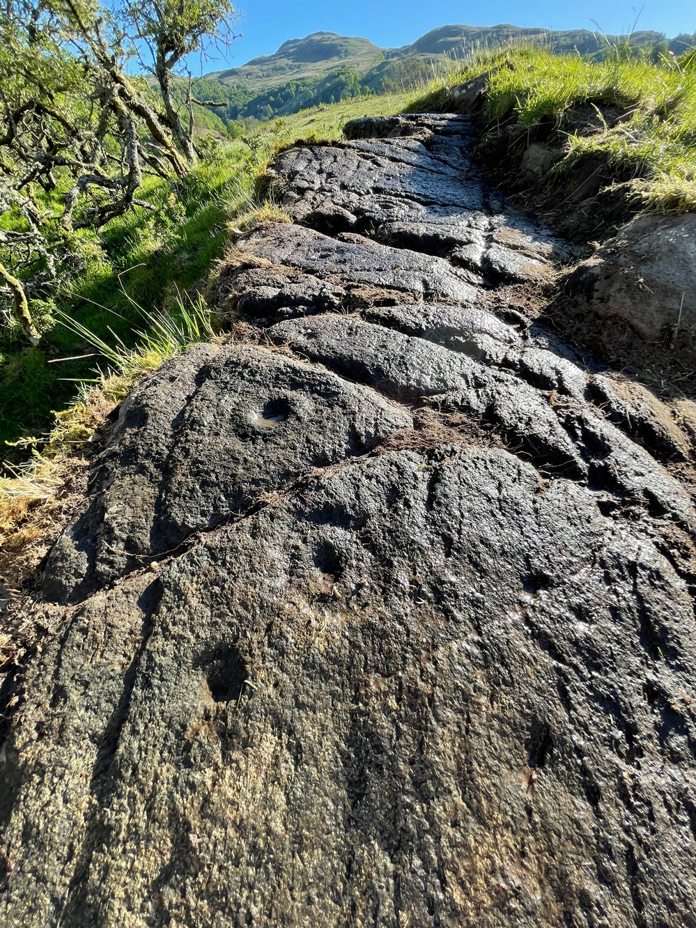
This is a relatively new find that was uncovered in 2019 by members of the Association of Certified Field Archaeologists, on the western edge of a small bowl of blackthorn trees, just past one of the Corrycharmaig East carvings — and it’s a bit of a beauty!
Topmost part of carvingCorrycharmaig (9) stone
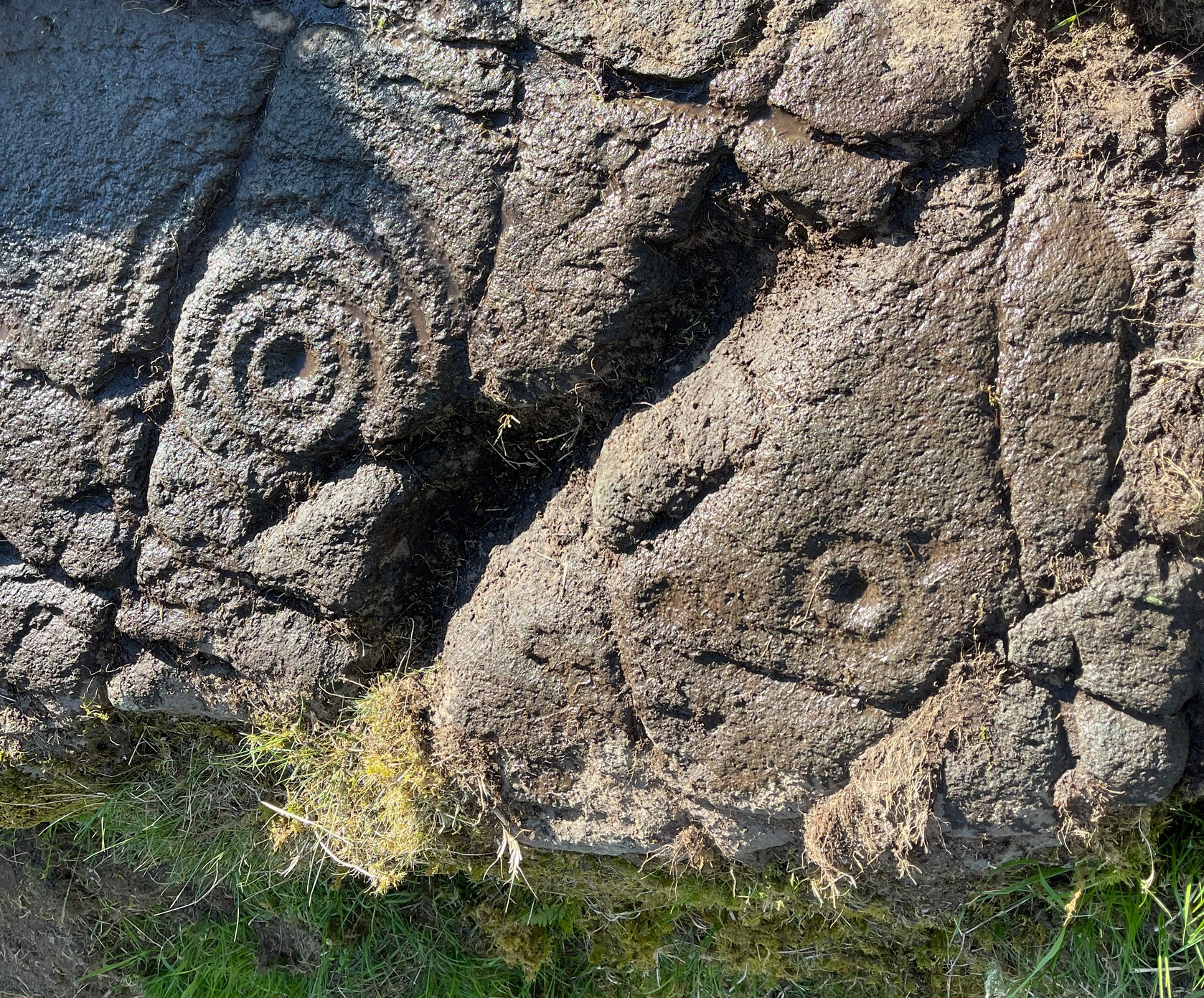
Described, albeit briefly, in the superb survey by Gardiner, King & MacInnes (2024), the carving here has been cut into a sloping straight line of rock along the ridge of a very tiny cliff and consists of cups, single rings and multiple rings. At its crown, so to speak, where the rock surface levels out and is flat, a very well-preserved multiple cup-and-ring greets our senses: a cup-and-four rings to be precise. The outermost edge of the rings cuts into a natural crack that runs to the edge of the stone; and close to where this crack reaches the edge, another standard cup-and-ring rests against it. On this same section you’ll see a single cup which, by the look of it, was intended to have a much wider ring surrounding it—but for some reason it was never executed.
Second multiple-ringerSecond multiple-ring
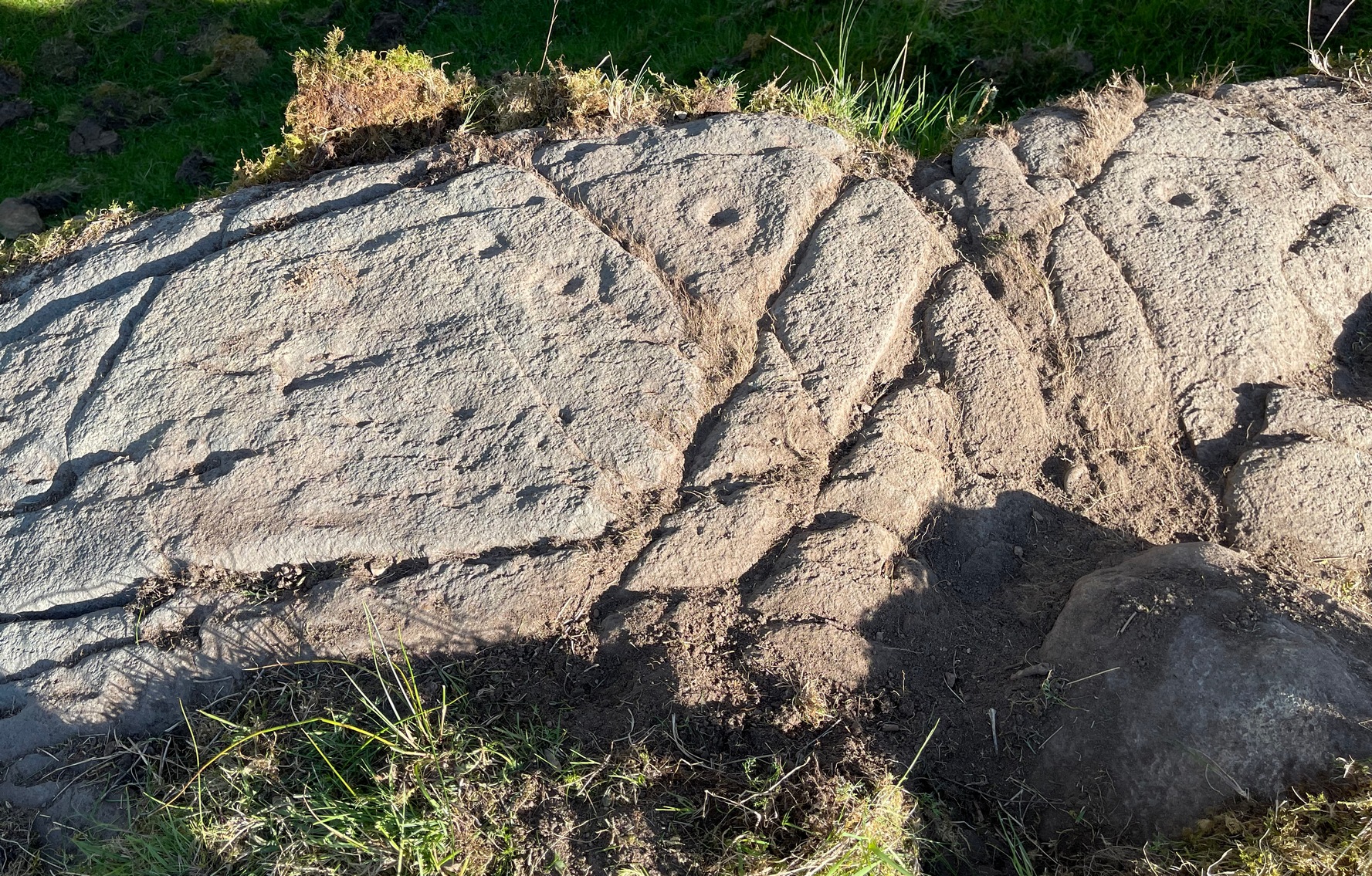
From the topmost section, the rock then slopes gradually downward and the design is broken by several natural splits in the stone before we reach a single unfinished cup-and-ring and a solitary cup-mark. These occur shortly before we reach a near-duplicate of the multiple-ringer that we’ve just seen on the flat top of the stone. The outer ring of this is broken and the edges of it are intruded (again) by natural cracks in the stone (a not uncommon feature). The erosion level of this and its fellow four-ringed compatriot at the top are much the same, suggesting that the two were executed at around the same time.
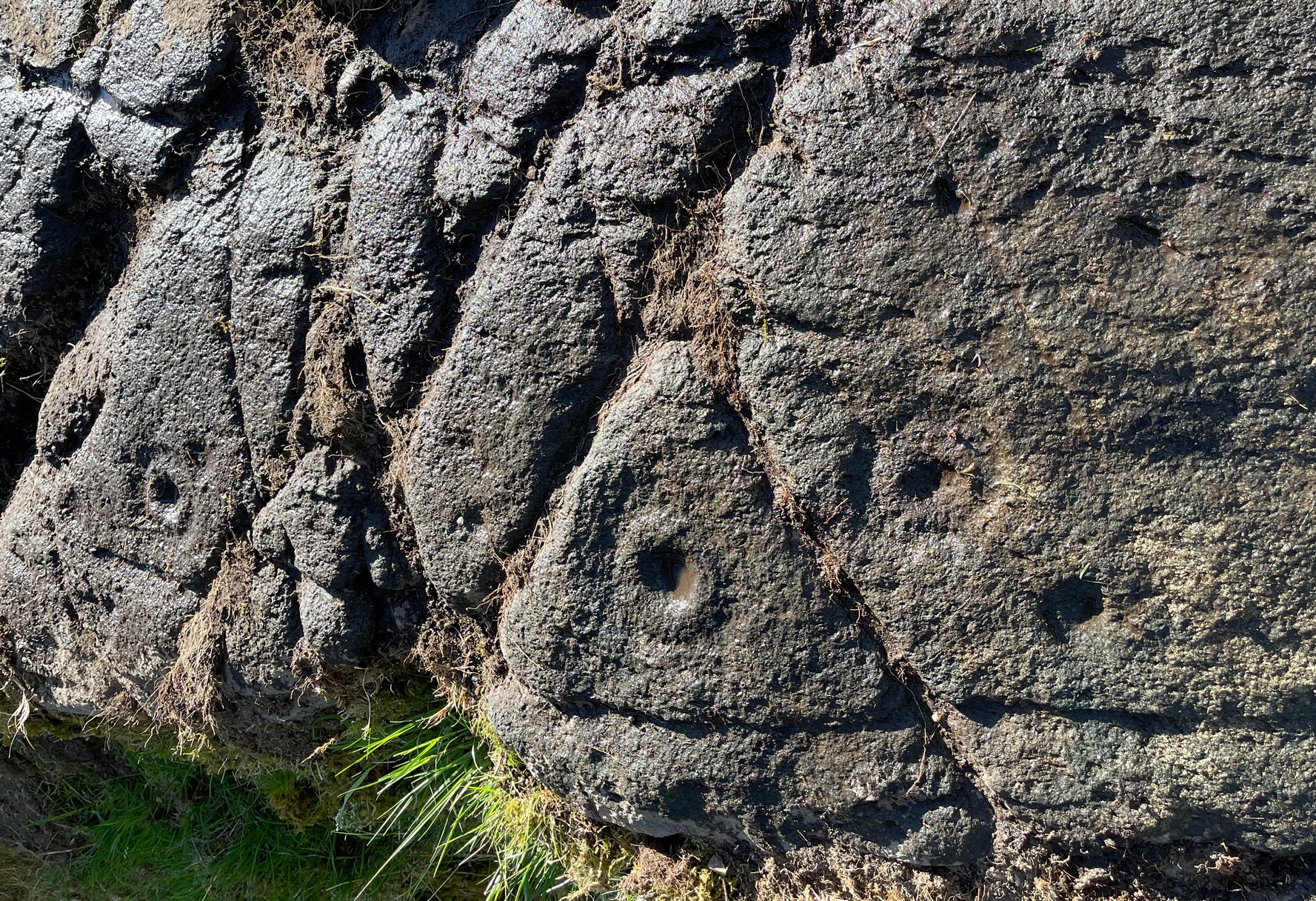
Lower-half with cup&ringsClose-up of cup&rings
As we move down the slope of the rock with its veritable scattering of geological splits, the rest of the design consists of several single cup-and-rings—at least three of them—over its lower-half, almost in a gentle arc over the surface. The one closest to the four-rings has a single cup-mark attached to its outer edge and another single one just a few inches away from it. The others don’t seem to have any additional carved features attached to them; although one or two other singular cup-marks can be seen on this, the lowest section of the carving.
Looking to the hillsFrom the bottom up
An interesting feature noted here is the direction that this line of rock points to: a dip between two distinct rocky peaks on the horizon and which is close to the winter solstice sunset. I should point out however, that the relationship between open air petroglyphs and astronomical alignments (in Britain at least) is very debatable. Even alignments from one carving to another are pretty meaningless, despite the attempts of some modern archaeologist to show otherwise. In my younger days when I raced into rock art studies, I threw everything I had to show astronomical and other alignments were involved in these carvings—but it turned out not to be…. Instead, it turns out that some of these seeming ‘alignments’ (and only a few) relate to pathways and ancient routes: pointers, if you like, to the way ahead. Makes sense…
References:
Gardiner, M., King, L. & MacInnes, Dugald, In the Glen of the Dark Goddess, Bell & Bain: Glasgow 2024.
Acknowledgements:Huge thanks for use of the Ordnance Survey map in this site profile, reproduced with the kind permission of the National Library of Scotland.
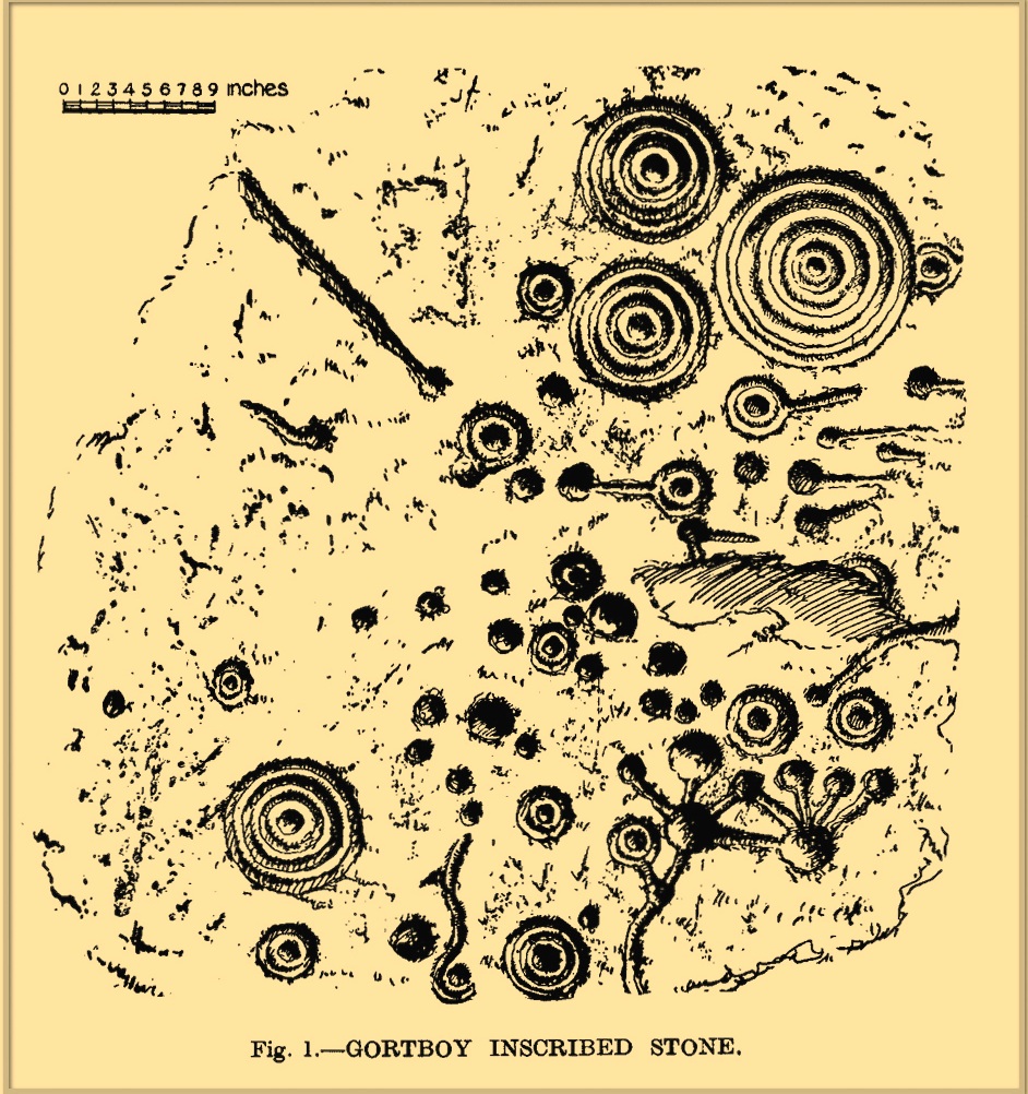
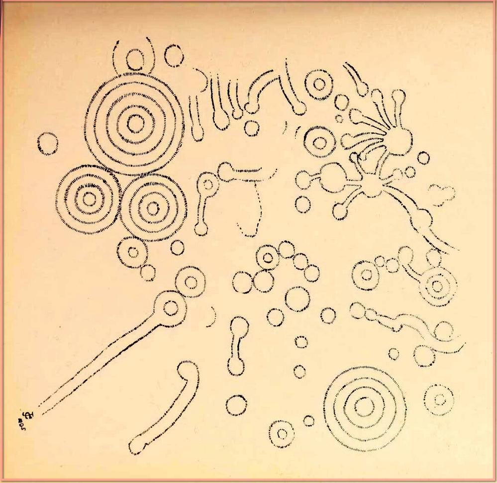
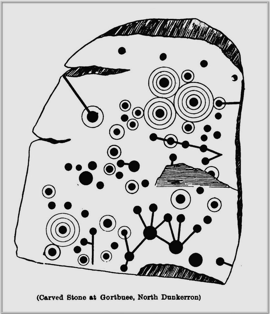
Cup-and-Ring Stone (destroyed): OS Grid Reference – V 838 896
Archaeology & History
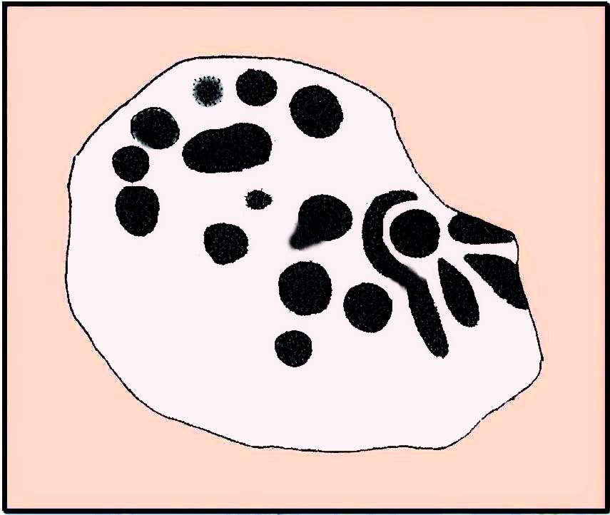
o’Connell’s 1939 sketch
In 1939 when D.B. o’ Connell wrote about this impressive cup-and-ring stone, he told that, with the exception of the Caherlehillan petroglyph (at V 569 837), this was “by far the most extensively decorated stone” that he’d seen in Kerry. He would therefore have been appalled to hear that it was subsequently destroyed in the 1950s and some remaining fragments of the stone “were used to line a well”! (o’ Sullivan & Sheehan 1996) Not good. There had already been an attempt to destroy the stone at the end of the 19th century, but that was prevented. Thankfully we had some early pioneer antiquarians who left us with information and sketches of this once great carving.
It was first described in John Cooke’s (1906) fine essay on the prehistoric antiquities scattering this part of Kerry. According to him, a certain “Dr. Digby is due the credit of having discovered this stone” a few years prior to him writing his essay. He told that:
Cooke’s 1906 sketch
“In one of the fields is a huge boulder, or rather earth-fast rock, somewhat rectangular in shape, of the purple grit of this district, and lying north and south. It measures 7 feet 8 inches long, 5 feet 8 inches broad at the south end, and 4 feet 6 inches at north end, the heights respectively being 2 feet 6 inches, and 2 feet 3 inches. A section from north to south would show a slight curve, as the rock is a few inches higher in the middle than at either end. The greater portion of this massive rock is covered with an extraordinary number of cup-markings, and cups with concentric circles. There are connecting channels everywhere, and the whole, though apparently intricate and unmeaning at first, yet shows, on examination, evidence of intention and design. It is much worn and weathered, and the north end has no markings. It is difficult to take a good rubbing of it, and still more difficult to sketch the markings, as the more it is examined, the more work does it show.”
This last comment applies to many petroglyphs. Mr Cooke continued:
“A peculiar feature of the ornament consists in the groups on the top left-hand corner, not unlike the tentacles and cupules of a cuttlefish. The dumb-bell-shaped ornament is found on other stones, but the truncheon-shaped figures on the right below are, I think, exceptional.”
A discrepancy arose a few years later when Miss C. Hussey (1909) told how the carving had been discovered by a certain “Captain Magill, who some years afterwards saved it from destruction.” She told how,
“One day, when shooting in the neighbourhood, he saw some men breaking it with crowbars, etc., merely to clear the field of stones, and his daughter, who first showed it to me, said she believed that before he reached the spot, some four feet or more had been broken off the broader (south) end.”
So whether it was him or Dr Digby, we may never quite know. As for the design, Miss Hussey told us:
Miss Hussey’s sketcho’Connell’s 1939 photos
“The stone itself is a large block of sandstone, some four feet in height, and six feet wide. The entire length at present is nine feet, but the flat carved top only measures seven feet four inches in length, as the northern side slopes gradually instead of being upright like the others. The largest circle on the stone is twelve inches in diameter, and the cups and hollows vary in size down to about an inch across. It was difficult to be certain whether some hollows were cups or merely natural inequalities in the stone, but I have only given those which seemed to be unmistakably the work of man” in this sketch.
In o’ Connell’s (1939) description he echoed what our earlier writers had said, and thankfully gave us a couple of photos of the carving, highlighting the design in chalk so we could see it clearer. It’s such a pity that it’s no longer with us…
References:
Cooke, John, “Antiquarian Remains in the Beaufort District, County Kerry,” in Proceedings of Royal Irish Academy, volume 26, 1906.
Hadingham Evan, Ancient Carvings in Britain: A Mystery, Garnstone: London 1974.
Hussey, C., “Gortbuee Cup and Circle Stone,” in Kerry Archaeological Magazine, volume 1, 1909.
o’ Connell, D.B., “Notes on Three Inscribed Stones in County Kerry,” in Journal Cork Historical & Archaeological Society, volume 44, 1939.
o’ Sullivan, Ann & Sheehan, John, The Iveragh Peninsula: An Archaeological Survey of South Kerry, Cork University Press 1996.
Acknowledgements:Huge thanks for use of the Ordnance Survey map in this site profile, reproduced with the kind permission of the National Library of Scotland.
In o’ Sullivan & Sheehan’s (1996) magnum opus, they reported the discovery of a decent cup-and-ring stone “during road-widening operations in the 1970s,” a short distance west of the river Staigue. It was “seen to have rock art motifs on it, but it has since been covered over.” Its design was apparently similar to a complex carving at found Liss (V 608 617), just 300 yards or so to the south.
References:
o’ Sullivan, Ann & Sheehan, John, The Iveragh Peninsula: An Archaeological Survey of South Kerry, Cork University Press 1996.