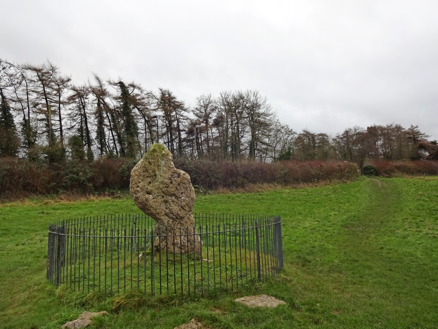
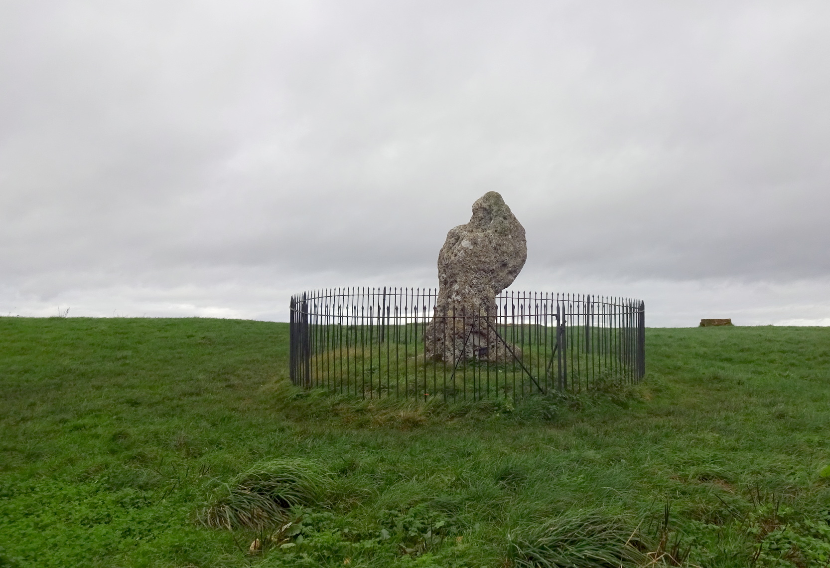
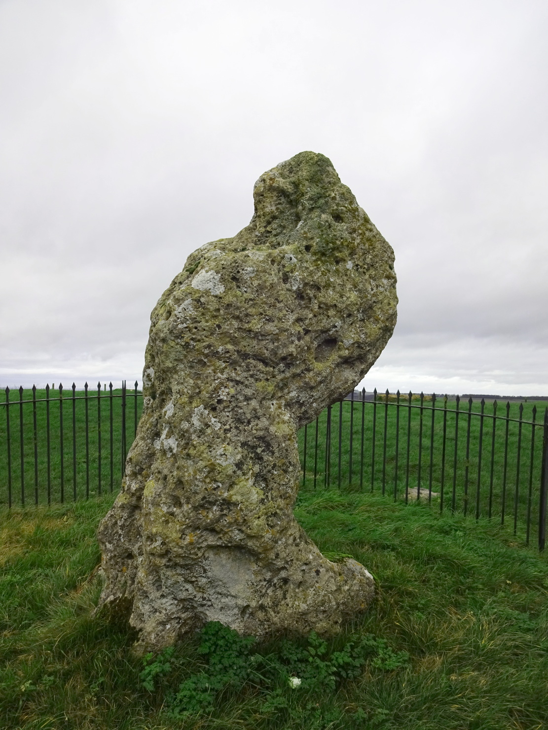
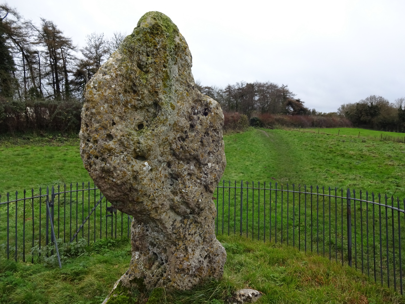
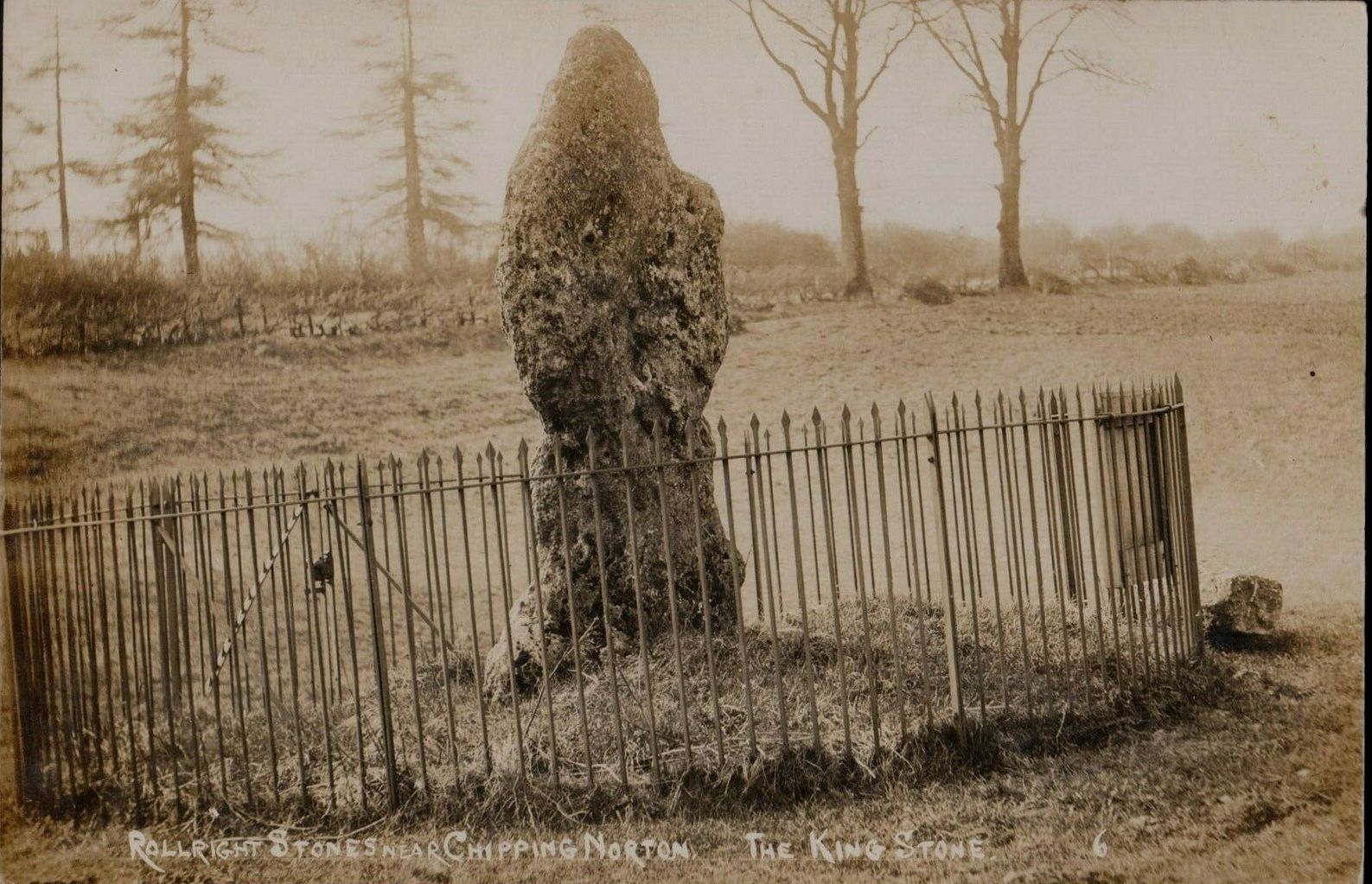
The King Stone of Rollright (photo by Sir Wilson III)
If you’ve reached the impressive Rollright Stone circle, simply cross the road, go through the gate and into the field, then up the gentle slope to your right. Y’ can’t miss it! If though, by any chance, you can’t find the Rollright Stones, get to Chipping Norton and ask a local!
Archaeology & History
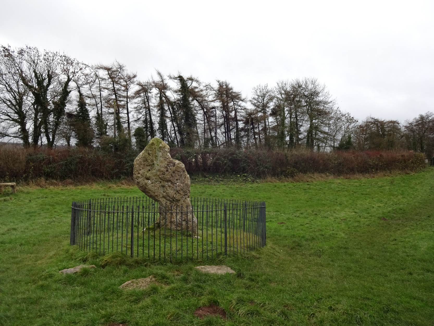
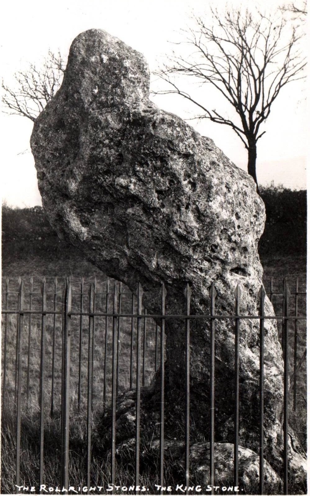
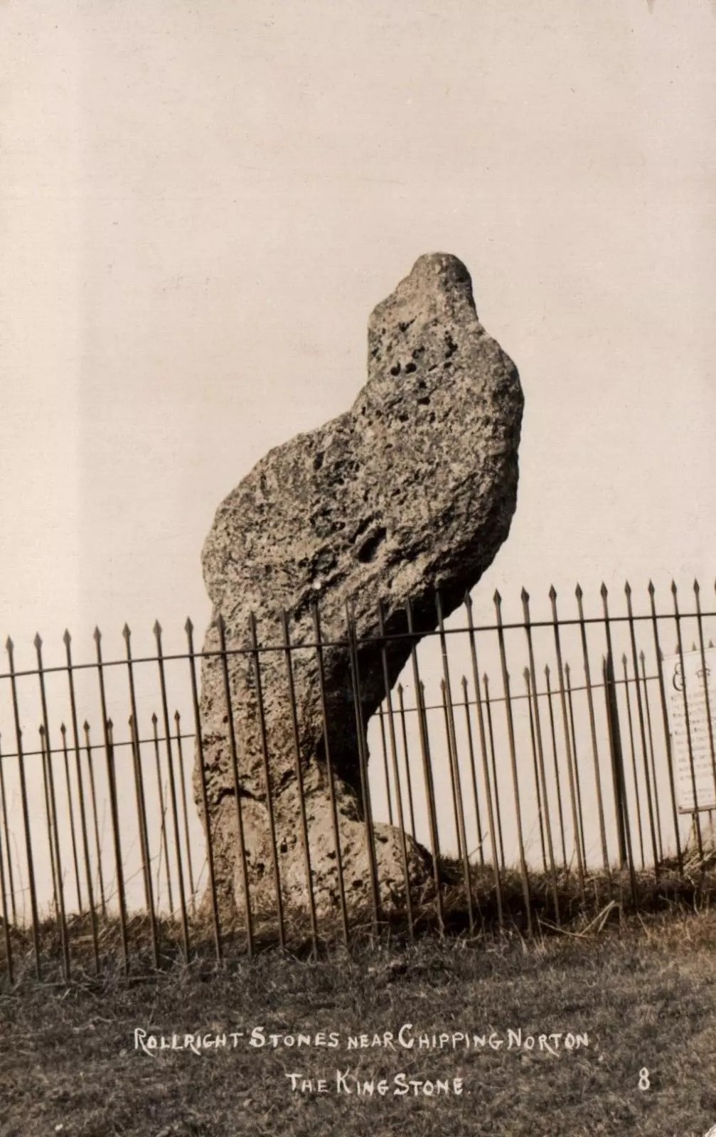
An integral part of the Rollright Stones complex, this gnarled almost moth-eaten-looking standing stone, whose edges were cut away for medicinal properties in earlier centuries, still awakes each morning beside the small rise in the field, long thought to have been the remains of an ancient tomb — much to the archaeologist’s opinionated disdain in bygone years. Yet they had to swallow their pride…
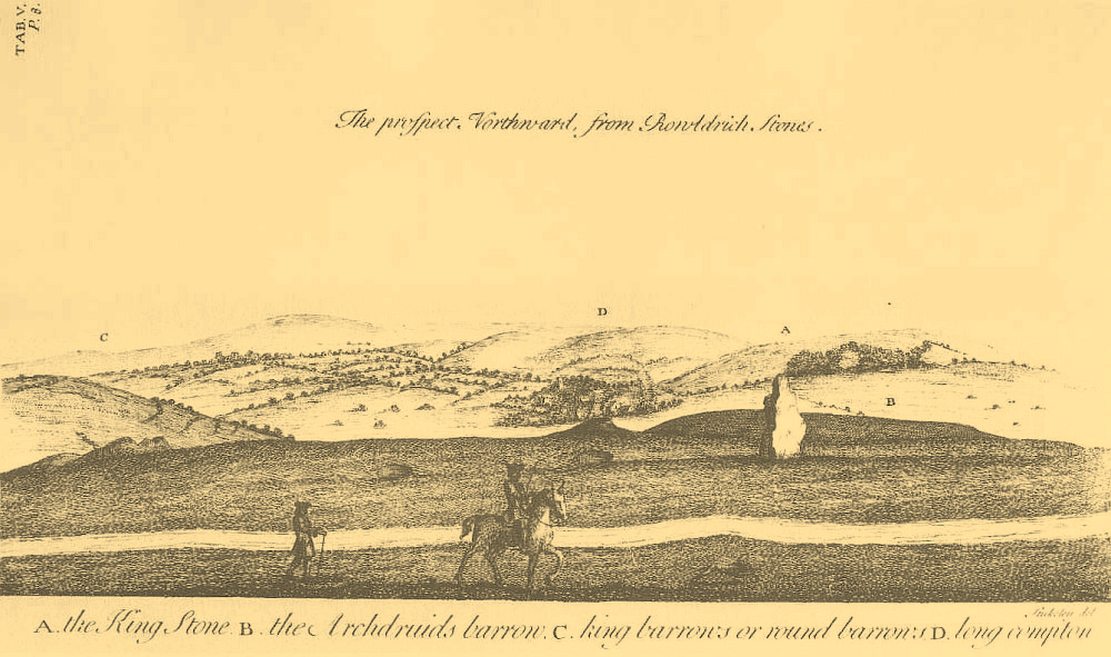
This is an eight-foot-tall standing stone made from the same local oolitic limestone as the King’s Men and overlooks the village of Long Compton on the northern side of the ridge. It actually stands besides an artificial mound which has been identified as a Bronze Age cairn—known in times past as the ‘Archdruid’s Barrow’— and suggested by Lambrick to date from around 1800 BCE. More recently however, the world’s leading authority on stone circles, Professor Aubrey Burl, has given the King Stone a more probable construction date of 3000 BCE. The date is consistent with other Neolithic finds in the adjacent fields. This old standing stone has suffered much down the centuries, with bits of it being chipped away to such an extent that it has been reduced to the novel shape we see today.
Looking up at the King (photo by Sir Wilson III)The King in dance
A little-known but important piece of megalithic history took place here in the 1970s and ’80s. It centred around an idea to investigation so-called “mysterious events” that are commonly reported at standing stones—and the King Stone has its own CV when it comes to such things. Curious stories have been described by people from all walks of life. Down the years, a number of people have told me of feeling some strange and powerful ‘energy’ at these places and stories of such things have filled many volumes, along with being the subject of many a folktale. So one evening in November, 1977, the then editor of The Ley Hunter, Paul Devereux, convened a meeting where twenty people from differing backgrounds gathered. At this first meeting were people from a variety of professional backgrounds: archaeologists, dowsers, chemists, biochemists, biologists, electronic engineers, geochemists, geophysicists, zoologists—and ley hunters of course. It was time, they thought, to address this issue of anomalous energies at stone circles and other ritual sites.
After some discussion about what they should call their investigations, “the long association of the dragon with some kind of earth force made it a fitting symbol.” And so, the Dragon Project (DP) was born…
On the misty morning of Saturday, 24 October, 1978, research scientist Don Robins—in the company of his dog and young son—drove the hundred miles from London to the Rollright Stones armed with a simple ultrasound detector. He didn’t know what he would find there, and his scientific training told him there shouldn’t really be anything untoward.
King Stone, looking W (photo by Sir Wilson III)Stukeley’s 1743 sketch showing the King Stone
Arriving around dawn, Robins took several background readings along some of the lanes a mile or so away and found the usual expected background levels (on a scale of 1-10, the background flickers between 0 and 1). When he eventually walked into the Rollright stone circle with his ultrasound monitor, no undue perturbations were found. He spent thirty minutes here, but at no time did he record anything other than background readings. So he crossed the road and tried the same at the King Stone—where a big surprise awaited him.
Switching on the detector he found an anomalously high reading, beating every minute or so, not unlike a heartbeat, more than five times above the background ultrasound!
“This was really peculiar,” he wrote, “in that the pattern was spread over about a minute and then commenced again after about 10 seconds, endlessly repeated.” Robins spent some time here and found that the strange ‘pulse’ wasn’t solely confined to the King Stone, but spread some distance around the old standing stone and onto the road itself.
Investigation of potential radiation anomalies was another avenue of enquiry explored by the Dragon Project, and although thousands of hours of monitoring were done at the three focal sites, there were few anomalies to write home about. Two however, were recorded in March and August, 1981, when radiation levels were twice the normal background rate for short periods of just a few minutes each. More puzzling was the finding—which can still be verified today—of radiation levels three and four times above background on the road between the circle and the King Stone.
Next on the list was an attempt to monitor the Rollright stones with infrared devices. This proved to be a potential goldmine, as there was the chance of photographic imagery. So early one morning in April, 1979, Paul Devereux readied himself at the King Stone. He took a number of photos at five minute intervals either side of sunrise. This time of day was chosen because of the repeated anomalous ultrasound emissions from the King and it was thought that this, if any, would be the best time to capture something on film.
“When the first roll of black-and-white IR film was professionally developed,” he wrote, “I was astonished to see a curious ‘glow’ effect around the King stone on the frame taken at sunrise.” His first account of it appeared in The Ley Hunter, where he described how “a hazy glow can be seen clinging to the sides and upper parts of the megalith. This glow becomes much stronger at the top of the stone where it looks like a cap of light.” Although the sun had risen, it was off to the left of picture and apparently no satisfactory explanation can be given to the effect on the plate. Research physicist Simon Hasler—who worked for Kodak—closely studied the negatives of this image and found the evidence for a simple explanation “weak.” A possible explanation of the mysterious glow was propounded by Don Robins, who suggested that an emission of microwaves from the stone may have been responsible, and although this sounds promising it has yet to be proven.
Folklore
(photo by Sir Wilson III)
Amidst the mass of modern lore, dowsed energy lines exceed here — although to be honest, most of them are little more than bullshit. Old school alignments in the form of leys that can be walked along are more credible, and one or two have been noted here. Dowser Laurence Main found a ley running between Broughton Church, “the old White Cross, the Victorian Cross and the old Bread Cross in Banbury. In the other direction the line led straight to the King Stone.” Although this line accurately links up these sites, other ‘ley points’ are utterly necessary between Broughton Church and the King Stone to give the alignment any real credibility. In a concise survey of the megalithic remains of this region made by Tom Wilson and myself, no other ley-points were found along the line.
In more traditional animist-based folklore, the creation myth here is well known. The famous, oft-repeated tale recites how a King and his men were marching across the land intent on conquering it when he came across an old hag, or witch near Rollright who offered the regal figure a magickal challenge. Some accounts name the witch as Mother Shipton—not the famous Yorkshire seer of the same name, but her less powerful (obviously!) southern counterpart. The old witch said to the King:
“Seven long strides thou shalt take, and
If Long Compton thou can’st see,
King of England thou shalt be.”
His majesty took this as a simple task and, with contempt, said to the old witch:
“Stick, stock, stone,
As King of England I shall be known.”
From where he was standing (which is never told, but presumed by most as the stone circle) the King then took seven long strides in the direction of Long Compton. As he was taking his seventh step the witch made the ground in front of him rise up, hence blocking his view of the village in the valley below. The old hag then said:
“As Long Compton thou canst not see,
King of England thou shalt not be.
Rise up, stick, and stand still, stone,
For King of England thou shalt be none;
Thou and thy men hoar stones shall be
And I myself an eldern tree.”
Thereupon, the King’s men who were waiting behind their master, the five knights in the field who were said to be conspiring against his majesty, and the King himself, were all turned into stone where they stood. The elder tree that the old witch turned herself into, was said to have grown along the old boundary close to the roadside, but this can no longer be verified. The folklorist Arthur Evans described several spots where the famed elder tree was said to have grown: one in the field close to the Whispering Knights, and another in the same field as the King Stone, close by another large stone that has long since gone.
When William Stukeley visited the area in the 18th century and heard about the legendary origin of these great monoliths, he told how “the country people for some miles round are very fond of, and take it very ill if anyone doubts it,” telling later, “The people who live at Chipping Norton and all the country round our first described temple of Rowldrich affirm most constantly, and as surely believe it, that the stones composing this work are a king, his nobles, and Commons turned into stones.
Another piece of animistic lore tells how the King Stone and the Whispering Knights venture, at midnight, less than half a mile south to drink from a spring in the small woodland at Little Rollright Spinney—although it is difficult to ascertain precisely which of the two springs the stones are supposed to visit. In some accounts, the stones reputedly drink from the well every night, but others tell that they only go there at certain times of the year, or on saint’s days. When Arthur Evans wrote of these tales he described there being a “gap in the bushes… through which they go down to the water,” but the terrain has altered since his day.
A variation of the same tale was told by T.H. Ravenhill, who wrote:
The old King c.1945King Stone, c.1920
“The Lord of the Manor of Little Rollright desired to possess the King’s Stone in order to bridge Little Rollright brook. So he dug it up and tried to cart it away, but found that he had not enough horses. He hitched on more, and yet more, and still he found that he could not move the stone. Finally he succeeded and hauled the stone away to the Manor House. The same night he was alarmed by strange sounds about the house, which he attributed to the presence of the King’s Stone, and decided, therefore, to replace it on its mound. No sooner had he harnessed the first horse to the cart than it galloped away up hill with ease, taking with it the stone, which leapt to position on reaching its resting place.”
Evans also wrote about an eighty-year-old local woman who told that her mother visited the King Stone on Midsummer’s Eve, along with many other locals, when the elder was in full bloom and they would stand in a full circle around the tall monolith. Ritual of a sort was performed then the elder tree was cut and, as it bled, “the King moved his head.” This annual rite was said to partially disempower the witch of her magickal hold over the King when her blood trickled from the tree. Some locals believed that if but a pin-prick of the witch’s blood was drawn, she would lose her power for all eternity.
Beneath both the Rollright stone circle and the King Stone, legend reputes there to be such a cavern where the little people live. In some accounts they are said to dance around the old King.
Arthur Evans told how one local man, Will Hughes, actually saw the faerie dancing round the King.
“They were little folk like girls to look at,” he said.
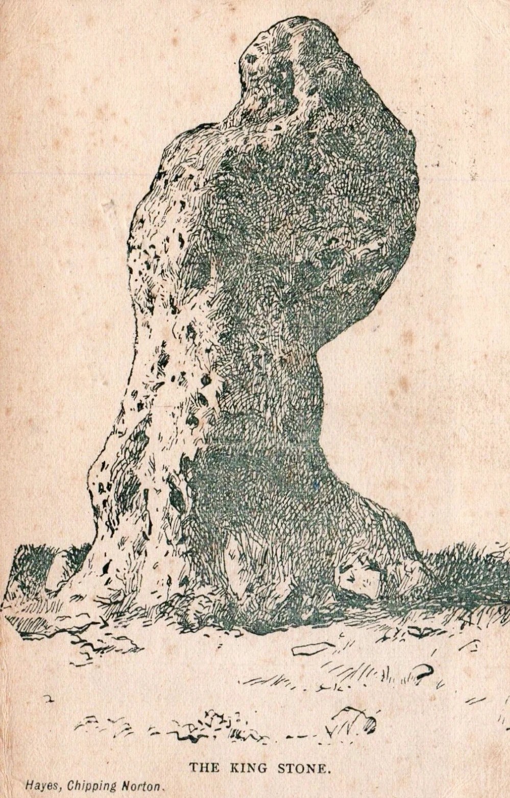
Old postcard, c.1910Sketch from 1904
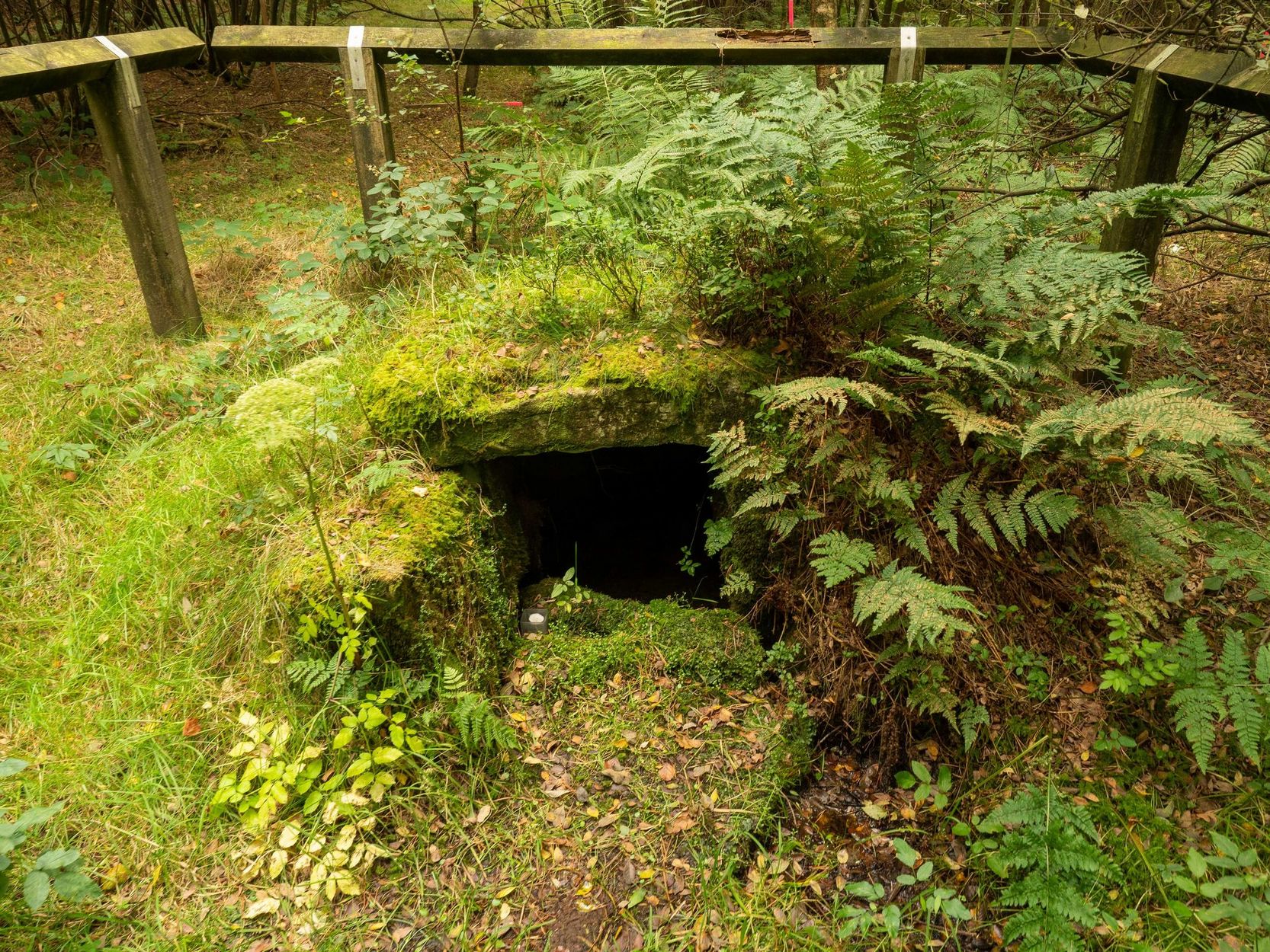
Will’s widow, Betsy Hughes, told Evans that “when she was a girl and used to work in the hedgerows, she remembered a hole in the bank by the King Stone, from which it is said the fairies came out to dance at night. Many a time she and her playmates had placed a flat stone over the hole of an evening to keep the fairies in, but they always found it turned over next morning.” This curious entrance was a neolithic burial mound. Mark Turner described how the little people were “supposed to come out and dance around the stones by moonlight.”
As we have already seen, people used to take chippings off some of the old stones here—primarily the King—supposedly for luck, protection and good fortune. Local people used to blame Welsh workers more than anyone, but they wouldn’t be the only ones! Although those who took such chippings believed the pieces brought them luck, more often than not it was the opposite that happened. One local woman told Evans about her son who went to India as a soldier in the 19th century with a piece of the King Stone in his possession, but it did him no good whatsoever. He died of typhus! The Oxford archaeologist George Lambrick (1988) highlights in his book on the Rollright stones the extent of damage that has been done to the King Stone since 1607.
References:
Anonymous, The Rollright Stones: Theories and Legends, privately printed, n.d.
Bennett, Paul & Wilson, Tom, The Old Stones of Rollright and District, Cockley: London 1999.
Bloxham, Christine, Folklore of Oxfordshire, Tempus 2005.
Cowper, B.H., ‘Oxfordshire Legend in Stone,’ Notes & Queries (1st series), 7, January 15, 1853.
Devereux, Paul, ‘Is This the Image of the Earth Force?’ in The Ley Hunter 87, 1979.
Devereux, Paul, ‘Operation Merlin,’ in The Ley Hunter 88, 1980.
Devereux, Paul, ‘Operation Merlin 2,’ in The Ley Hunter 89, 1980.
Devereux, Paul, ‘The Third Merlin,’ in The Ley Hunter 92, 1981.
Devereux, Paul, Places of Power, Blandford: London 1990.
Devereux, Paul, The Sacred Place, Cassell: London 2000.
Evans, Arthur J., ‘The Rollright Stones,’ in Trans. Bristol & Glouc. Arch. Soc., 40, 1892.
Evans, Arthur J., ‘The Rollright Stones and their Folklore (3 parts),’ in Folklore Journal, 1895.
Lambrick, George, The Rollright Stones: The Archaeology and Folklore of the Stones and their Surroundings, Oxford Archaeology Review 1983. (Reprinted and updated in 1988.)
Michell, John, Megalithomania, Thames & Hudson: London 1982.
Pennick, Nigel & Devereux, Paul, Lines on the Landscape, Hale: London 1989.
Ravenhill, T.H., The Rollright Stones and the Men Who Erected Them, Little Rollright 1926.
Holy Well (lost): OS Grid reference – SW 3550 2626
Archaeology & History
The springs of Chapel Idne
Highlighted on the 1888 Ordnance Survey map of Sennen Cove are the remains of Chapel Idne, just above the coast. Across the road from the chapel on its south-side, and also next to an old inn to its immediate west, springs of water are shown and it would seem more than likely that one of these two would have been the forgotten holy well of Sennen that was described, albeit briefly, in the great Mr Blight’s (1861) literary tour of the area. He told us that:
“At Sennen Cove was an ancient chapel, called by the people Chapel Idne, the “narrow chapel” being forty-five feet long and fifteen feet wide. It is now converted into a dwelling. Tradition says it was founded by one Lord of Goonhilly, who possessed dome portion of the land of Lyonesse. There was a holy well of some repute here also.”
The waters of St. Sennen’s Well were used in an act of ceremonial magick in the Arthurian tale known as the Battle of Vellan-druchar, as told in Robert Hunt’s (1865) great Romances. An attempted invasion by the Danes was met with by Arthur and nine other kings and the foreigners were slaughtered.
“A few had been left in charge of the ships, and as soon as they learned the fate of their brethren, they hastened to escape, hoping to return to their own northern land. A holy woman, whose name has not been preserved to us, “brought home a west wind” by emptying the Holy Well against the hill, and sweeping the church from the door to the altar. Thus they were prevented from escaping, and were all thrown by the force of a storm and the currents either on the rocky shore, or on the sands, where they were left high and dry. It happened on the occasion of an extraordinary spring-tide, which was yet increased by the wind, so that the ships lay high up on the rocks, or on the sands; and for years the birds built their nests in the masts and rigging.
Thus perished the last army of Danes who dared to land upon our western shores.
King Arthur and the nine kings pledged each other in the holy water from St Sennen’s Well, they returned thanks for their victory in St Sennen’s Chapel, and dined that day on the Table-men.
Merlin, the prophet, was amongst the host, and the feast being ended, he was seized with the prophetic afflatus, and in the hearing of all the host proclaimed–
“The northmen wild once more shall land,
And leave their bones on Escol’s sand.
The soil of Vellan-Druchar’s plain
Again shall take a sanguine stain;
And o’er the mill-wheel roll a flood
Of Danish mix’d with Cornish blood.
When thus the vanquish’d find no tomb,
Expect the dreadful day of doom.”
References:
Blight, J.T., A Week at the Land’s End, Longmans Green: London 1861.
Hunt, Robert, Popular Romances of the West of England, 1865.
Straffon, Cheryl, “Chapel Idne and the Holy Well,” in Meym Mamvro no.34, 1997.
Weatherhill, Craig, “A Guide to Holy Wells and Celebrated Springs in West Penwith,” in Meym Mamvro no.4, 1997.
Acknowledgements: Big thanks for use of the early edition OS-map in this site profile, Reproduced with the kind permission of the National Library of Scotland.
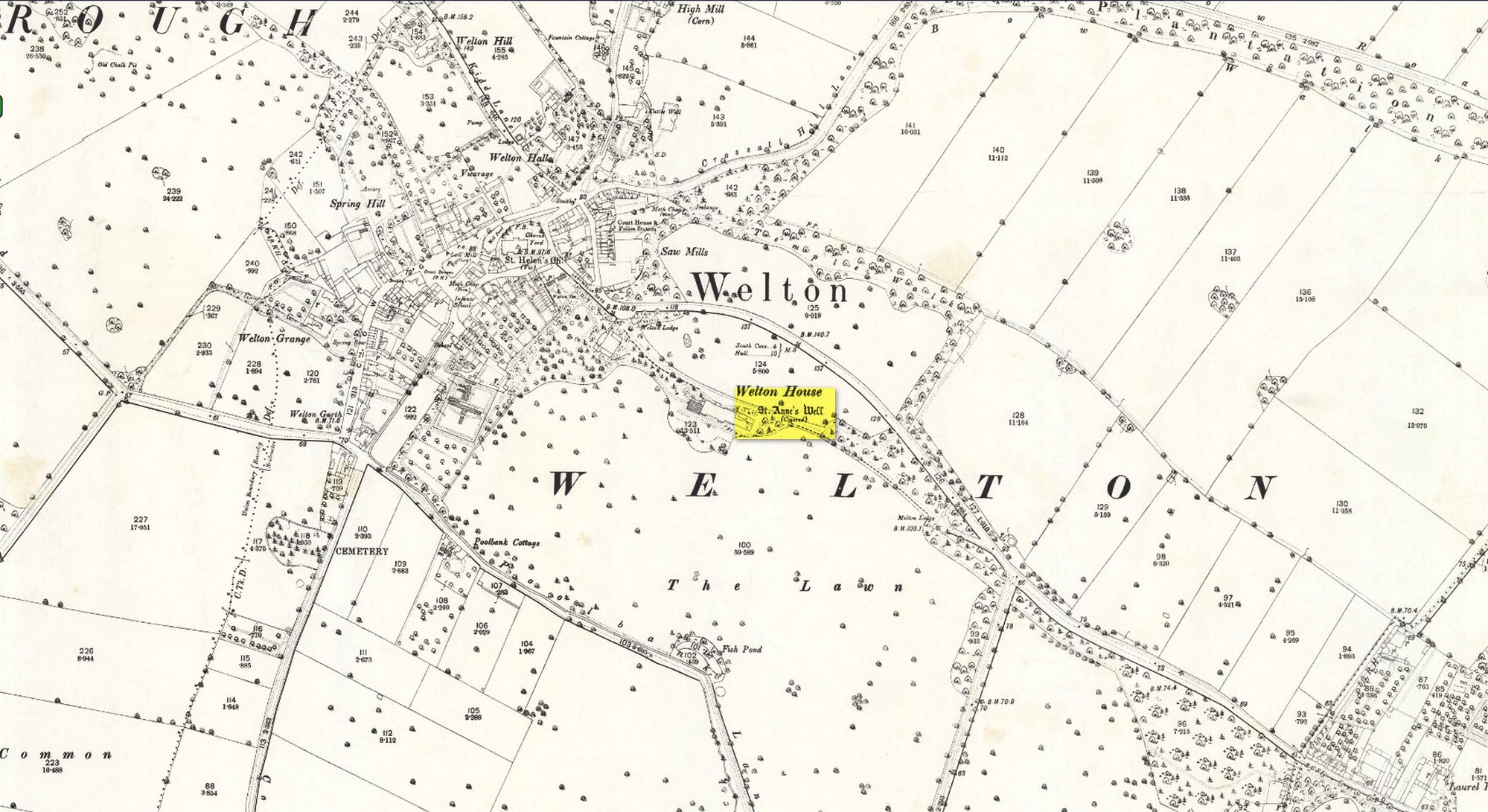
Shown on the early 25-inch-to-the-mile Ordnance Survey map of the area, this is a frustrating site. In Thompson’s (1870) early history of Welton village, he says very little about this place, other than:
“Then there is Saint Ann’s Well, which supplies Welton House with spring water.”
Site shown on 1890 map
Even worse is the fact that in William Smith’s (1923) survey of East Yorkshire holy wells, he merely copies Thompson; and in Jeremy Harte’s magnum opus he does exactly the same thing! Not good. Thankfully the local artist and singer, Gaynor Perry, helped us out big time! She grew up in this area and used to play here when she was young, but at the time she had no idea that the well where she’d played had any magical traditions attached to it. This discovery happened many years later. Regarding the present condition of the well (as of 2017), she told:
“The well has been covered with stone slabs for a long time (and) a tree has tried to grow over it. It has been sheltered here over the years in the grounds of Welton House, a large estate which was demolished in 1952.”
The well can still be seen in the small copse of trees immediately north of St Anne’s College. There is the possibility that this holy well gave its name to the village of Welton itself. First mentioned in 1080 CE, the place-name means “the well near the farm,” (Smith 1937) although there is no direct linguistic association with St. Anne, so we don’t know for sure.
Folklore
St. Anne is a curious saintly figure and one of my personal favourites. St Anne (saint’s day – July 26) was a giant in early christian and Islamic myths. An apocryphal figure, She was the Great Mother of the mother of Christ—the Virgin Mary—and was Herself a Virgin until, in Her old age, after seeing a bird feeding a chick, decided She wanted a child and so eventually gave birth to Mary. An old woman giving birth when the Springtime appears (when birds and other animals become fertile) is the same motif found in the lore of the Cailleach in Ireland and Scotland (and parts of northern England). A pre-christian mythos was obviously at play here in bygone times…
Tumulus (destroyed): OS Grid Reference – NT 9323 2800
Also Known as:
Auld Wife’s Apronful o’ Stanes
Tom Tallon’s Tumulus
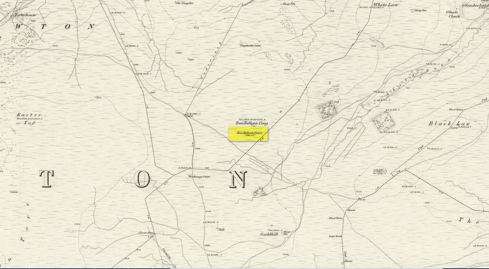
Archaeology & History
Site on the 1866 OS-map
Highlighted on the earliest OS-maps about half a mile to the south of the great prehistoric camp of Yeavering Bell and 100 yards southwest of Tom Tallon’s Crag, there once stood an apparently “massive” Bronze Age tumulus, or cairn, called Tom Tallon. I’d hedge a bet that it was much older, from the neolithic period. It was described by P.A. Graham (1921) as “the largest cairn in the district,” but when it was visited by the antiquarian Henry MacLauchlan in July 1858, he reported that “it was being removed to make a fence”!!! Unbe-fuckin’-lievable… Who were the dickheads that did that?!
Folklore
The Ordnance Survey Name Book of 1860 for Tom Tallon’s Crag told that,
“There is a vague tradition about Tom Tallon having been a Warrior and Slain here – hence the name, but nothing authentic respecting Tom, can now be ascertained.”
The word tom derives from “a rounded hill”, sometimes associated with a tumulus and in Scotland (just over the border) associated “with a dwelling place of the fairies” with tallon suggested by Graham (1921) to derive from “tal, a forehead or promontory, and Llan, an enclosure.”
What is quite obviously an older name, or certainly one that was more recognised by local people, is its title of the Auld Wife’s Apronful of Stones: a title we find associated with a number of the giant cairns in northern England and Scotland. It relates to the creation myth of the site, whereby the countless stones that made up the cairn were dropped or thrown across the landscape by a giantess who inhabited this area.
References:
Hall, James, A Guide to Glendale, M. Brand: Wooler 1887.
MacLauchlan, Henry, “Notes on Camps in the Parishes of Branxton, Carham, Ford, Kirknewton and Wooller, in Northumberland,” in History Berwickshire Naturalists Club, volume 24, 1922.
Holy Well (destroyed): OS Grid Reference – SE 2997 5561
Also Known as:
St. George’s Spa
Archaeology & History
About 50 yards away from the Royal Promenade on the east-side of Parliament Street, there used to flow the healing waters of an old holy well, that later became one of Harrogate’s many spa wells. It was first recognized as a medicinal spring about 1792 when Thomas Garnett (1794) uncovered it beneath the overgrowth of vegetation surrounding the spring-head. In doing so, it became evident that at some time in the past it had been used by local people as,
“a wall was discovered round the spring, but whether this had been built with an idea of its being a medicinal water, or with an intention of collecting water for cattle, I cannot determine.”
Chalybeate (iron-bearing) in nature, the waters were analyzed by Adam Hunter (1830) in the 1820s and, although possessed of soluble iron, had less than its medicinal compatriots nearby, meaning that its fortifying qualities weren’t quite as good. He told us how,
“it had been known (by locals) for many years, but at no time much used internally; it had acquired some celebrity however as a wash for sore eyes, for which purpose it was well adapted. As chalybeate water has long been a favourite popular remedy for a wash in various weaknesses, and chronic affections of the eyes, it is proper to state that (the nearby) John’s Well, the Tewit Spa, or the succeeding one at Starbeck, are the only three chalybeates which can at present be recommended for that purpose.”
A few years after Hunter had been here, the well was destroyed “by the making of a highway drain.” (Jennings 1981)
Folklore
St George (saint’s day – April 23) was one of the christian dragon-killers. There is no known tradition of the saint or festivities that may once have occured here.
References:
Garnett, Thomas, A Treatise on the Mineral Waters of Harrogate, Thomas Gill: Leeds 1794.
Hunter, Adam, The Waters of Harrogate and its Vicinity, Langdale: Harrogate 1830.
Jennings, Bernard, A History of the Wells and Springs of Harrogate, Interprint: Harrogate 1981.
Very little is now known about this sacred site that was once found “a few hundred yards east from the New Church at Low Harrogate.” (Hunter 1830) Even most of travellers and medical experts who wrote about the numerous Harrogate wells in the 18th and 19th century bypassed its quietude; and by the time Mr Hunter wrote about it in his great descriptive catalogue, its healing or medicinal qualities had been forgotten.
He told that “the spirit in the water…or that with which it is infused, has long been most actively engaged in adding real or fancied comforts to the (Harrogate) Fair, and is now in much more general use” than the two other holy wells in the town. It was, he said, “the best water for making tea and more extensively used for that purpose than any in the neighborhood of Harrogate.” It would also appear to have been built over at some time in the not-too-distant past…
Folklore
St Ann (saint’s day – July 26) was a giant in early christian and Islamic myths. An apocryphal figure, She was the Great Mother of the mother of Christ—the Virgin Mary—and was Herself a Virgin until, in Her old age, after seeing a bird feeding a chick, decided She wanted a child and so eventually gave birth to Mary. An old woman giving birth when the Springtime appears (when birds and other animals become fertile) is the same motif found in the lore of the Cailleach in Ireland and Scotland (and parts of northern England). Pre-christian lore at this old well would seem evident here.
References:
Hunter, Adam, The Waters of Harrogate and its Vicinity, Langdale: Harrogate 1830.
Legendary Rock (destroyed): OS Grid Reference – NJ 89397 49502
Also Known as:
Crawey Stone
Crawford Putting Stone
Crawstane
Devils Putting Stone
Archaeology & History
Stone shown on 1874 map
A site whose main claim to fame is its legendary nature. Seemingly buried or destroyed around the end of the 19th century, there have been suspicions that the stone might have had cup-marks on it (see Folklore below), but we’re not sure. Modern lore tells that when roadworks were done here in the 1950, a large stone was uncovered. A local man who was passing by told that he’d seen the Crawey Stone in his youth and that the stone they’d uncovered was one and the same.
Folklore
The story that used to be told amongst local people was thankfully preserved in an article by the pseudonymous “Mormond” (1889) in Scottish Notes & Queries. He told that:
“In the parish of New Deer, and in a field near the Old Castle of Fedderat, there is a large boulder of ten or twelve tons known as the Crawey Stone. I am unable to say if it still occupies its old site, or if it has been broken up for building purposes. The legend connected with this stone used to be well known in the parish, and a version of it appeared in The Aberdeen Magazine some 70 or 80 years ago. This version is substantially the same as the legend known in the district, and relates how a Crawford, the lord of the castle and lands, one day “as he looked o’er his castle wa’ ” — a phrase which often occurs in old ballads — observed a crunkled carl (old woman or witch, PB) inspecting the stone and afterwards successfully lifting up one end clear of the ground. Not to be conquered by such a shabby looking stranger, the laird, who was famed for his athletic powers, went out and challenged the carl; but on attempting to lift the boulder, burst a blood vessel; and the carl, who stood by watching him, suddenly disappeared in a flash of fire taking the remains of the laird along with her. The tradition is that the laird was not mourned for in the district, and the moral drawn was “He couldna hae expected ony ither en’.” When passing the boulder going to school, the legend was often referred to, and some indentations on it pointed out as the marks of the ill man’s fingers made at the time the superhuman feat was accomplished.”
These finger marks have been taken as possible cup-markings. They might have been, but we simply don’t know; they may just have been curious natural markings that gave rise to this animistic creation myth. Another tale told that the markings were due to an old giant in the neighbourhood who used the rock as a putting stone and rolled it to the spot where it used to stand. Giants are always attached to indigenous creation myths, some of which go back thousands of years.
“a large Stone of a roundish shape, built on an old fence, forming a side of the Public road leading from New Deer to Brocklay. Tradition asserts that it has been the putting Stone of a Giant in ancient times. There are Several holes in the Stone said to be the finger marks of the Giant.”
Holy Well (lost): OS Grid reference – SW 4025 3062
Archaeology & History
Just over a mile northwest of the superb Sancreed Well, we find documentary evidence from 1778 recording the field-name of Chapel Well Close here, although there seems to be no remaining spring or well and nothing is shown on the early OS-maps. Official records define it as a “medieval well” and speculate that it may have been associated with the nearby Boscence Chapel and possibly dedicated to St. Winwaloe.
References:
Anon., The Church and Parish of Sancreed in the County of Cornwall, Brewer: Sancreed c.1960.
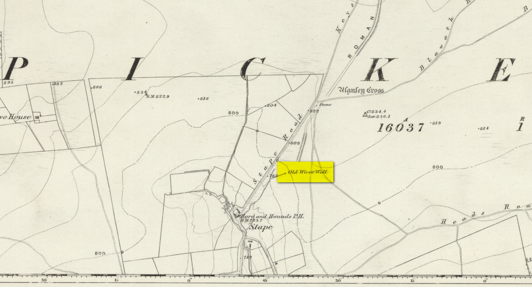
The history of the site is scanty to say the least. It first seems to have been recorded when the Ordnance Survey lads came here in the 1840s, although they left no record as to why the site was given such a dedication. It’s a decidedly pre-christian title as the name “old Wife” is usually indicative in northern counties as being related to the primal Earth deity of northern England and lowland Scotland (when we reach the Highlands and Ireland, She becomes known—amongst other names—as the cailleach). However, apart from its name we have no additional information. Neither the holy wells writer Edna Whelan (1989; 2001), nor hydrolatry researcher Graeme Chappell were been able to find anything about the place in their own researches. And so we must go on name alone…
The waters bubble up into a small stone-lined chamber with the words Nattie Fontein carved into the lintel. This is something of a mystery in itself, for, as Edna Whelan (1989) told,
“it would be most unusual for the word fonten to be used for a spring in North Yorkshire: ‘keld’ is the local word. The rather roughly inscribed word may be a corruption of Fons Natalis, the name of a Celtic water nymph.”
Graeme Chappell (2000) meanwhile, noticed in a visit to the site in June 1999,
“that the N and A in “NATTIE” are carved in such a way that the word could be read as “MATTIE FONTEIN” perhaps meaning “Mother Fountain”. This might then be another reference to the Old Wife?”
He then goes on to note how,
“the latin word ‘natalis‘ meaning ‘birth’ and its link with the roman Festival ‘Dies Natalis Sol Invictus‘ (day of the birth of the unconquered sun) which took place on the 25th December. Natalis also gave rise to the welsh word ‘Nadolig‘ – meaning Christmas.”
This Yuletide element has an intriguing relationship with the name of the well; for to the west of Yorkshire’s borders into Cumbria there was annual gathering known as Old Wives’ Saturday that took place on the first Saturday after Christmas, or first Saturday of the New Year in a person’s house or inn, where a feast was had to bring in the New Year; but there is no known written lore of such a tradition here.
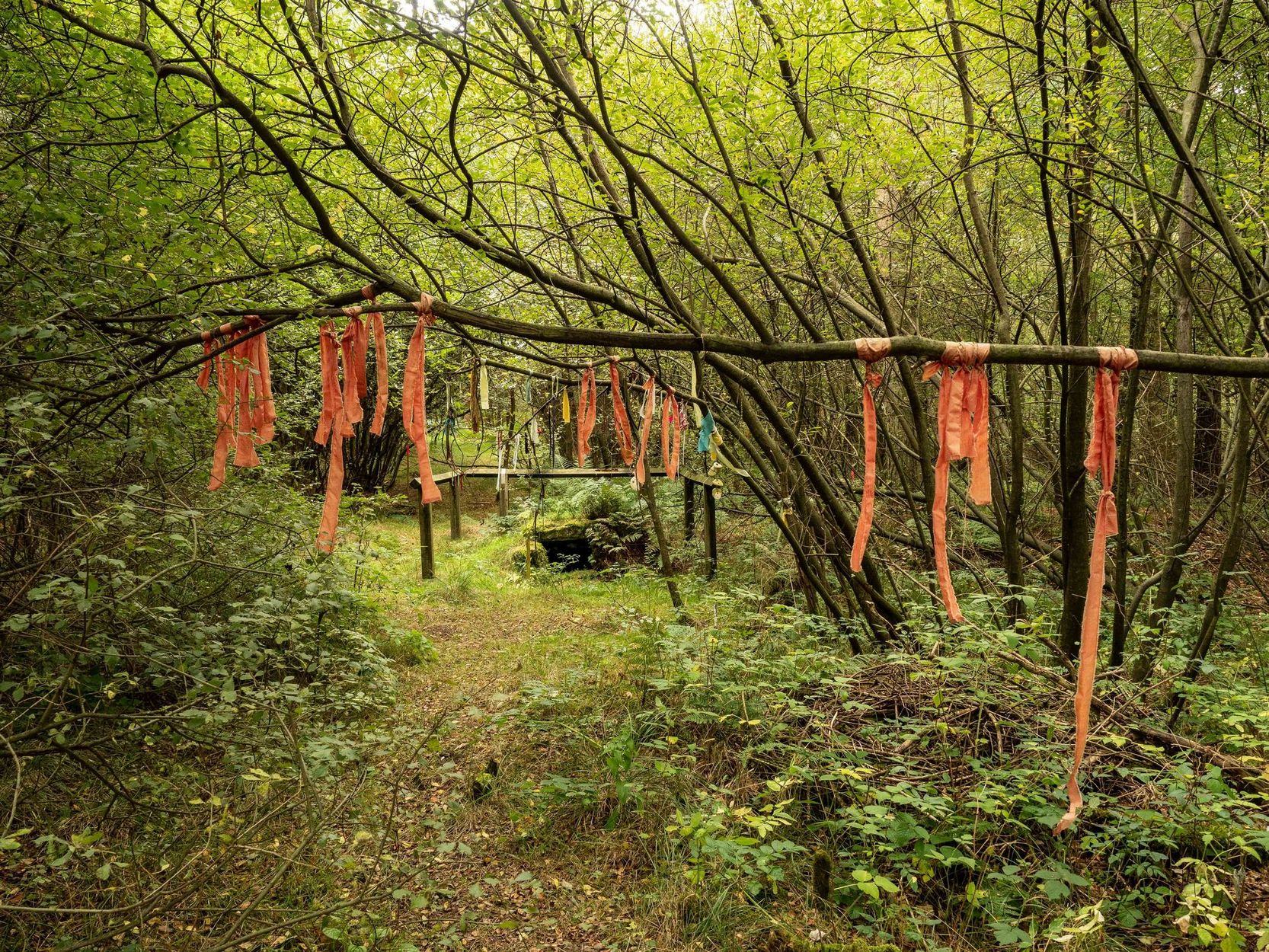
Nowadays the old tradition of hanging rags on the trees surrounding the well as offerings to the spirit of the place (known as memaws in parts of Yorkshire, and clooties in Scotland) has become a regular practice of those who hold such sites as sacred in their own way. Whelan mentioned seeing memaws here in the 1908s, but the Northern Antiquarian contributor Jon Barker told that, “The rags are a comparatively recent addition to the well, it is not a tradition there. When I used to go in the ’60s therewere no rags.”
On an even more curious note: very recently (from when this profile was written), the Northern Antiquarian contributor and photographer James Elkington visited Old Wives’ Well for the first time. It was a grey overcast day and when he arrived here, there was a woman ahead of him at the head of the well. I’ll let him tell the rest of it in his own words:
The Old Wives Well, Stape (James Elkington)Old Wives Well at Stape (James Elkington)
“In front of the well was a lady dressed in what looked like a white nighty, she had her back to me. There was a candle lit nearby, and her hands were in the water moving slowly about like she was washing something. She had long dark shoulder length hair. As I was about 25 feet away I was sure she wasn’t aware of me, and I thought it would make a good photograph. I quietly put my bag on the ground and got my camera out, and looked up and…she was gone! I couldn’t have taken my eye off her for more than 5 or 6 seconds. I looked all around and there was no sign of her. Even if she had legged it through the woods I would have seen her. I think it was then that I realized that I may have had ‘an encounter’. I quickly took three pics of the Well and got the hell out of there!”
He rang me once he had regained his senses in a somewhat emotional state and recounted over and over what had just happened. Whether this was a visual manifestation of the genius loci of the we can’t say. But such encounters are not unknown at numerous sacred water sites all over the world. We can only hazard a guess that this is what he was fortunate to encounter.
Just a few hundred yards north is the old Mauley or Malo Cross, which may or may not have had some mythic relationship with our Old Wives…
Holy Well (destroyed): OS Grid Reference – NS 6983 4138
Archaeology & History
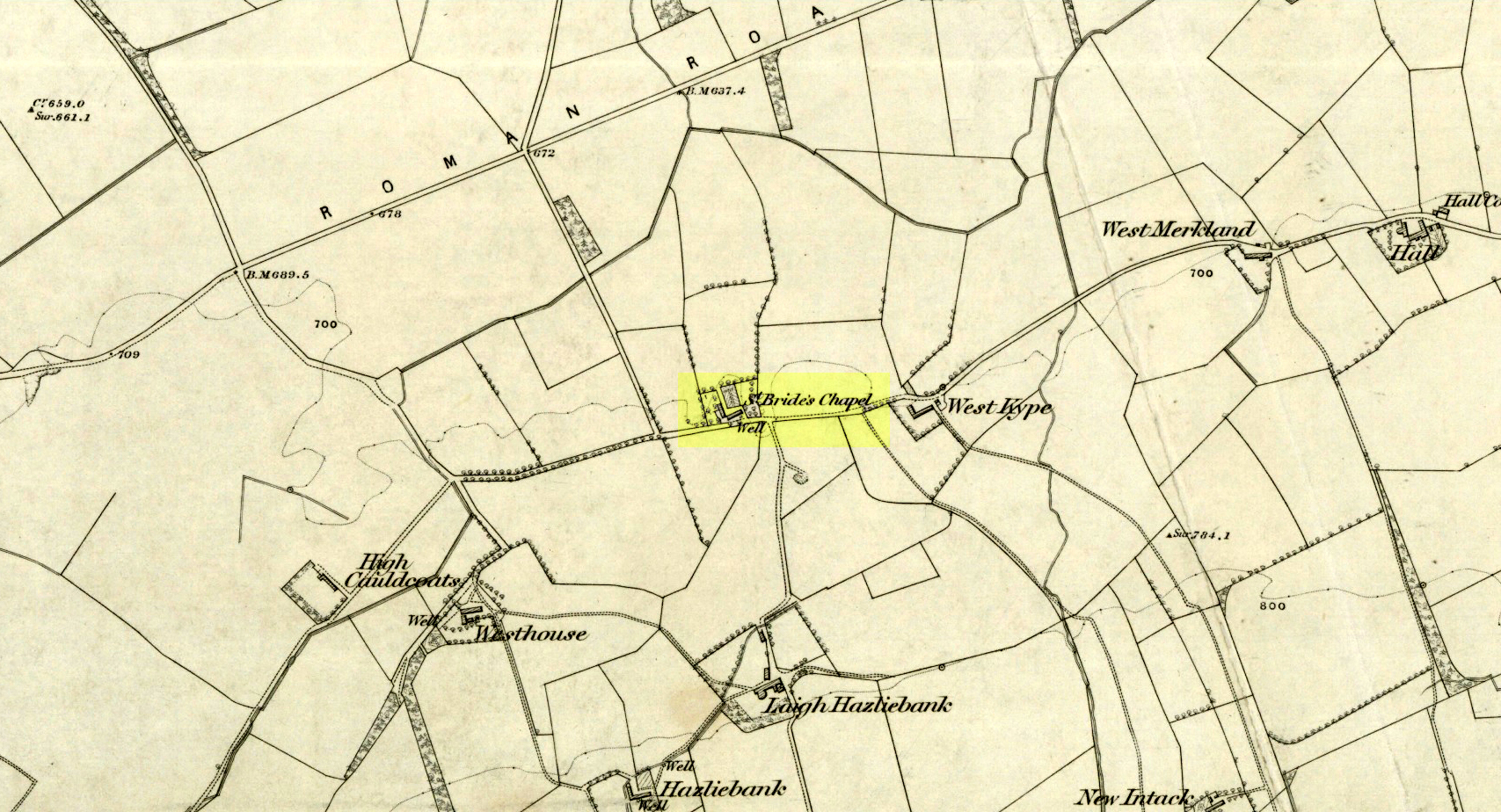
St Brides Chapel & Well on the 1864 OS-map
Shown on the 1864 OS map of the area as a ‘Well’ just at the front of St Bride’s Chapel—now a very pleasant old cottage—peasants and pilgrims would stop for both refreshment and ritual here as they walked down High Kype Road. Although the chapel was described in church records of January 1542 as being on the lands of Little Kype, close to the settlement of St Bride, there seems to be very little known about the history or traditions of the well. If anyone has further information on this site, please let us know.
Folklore
Bride or Brigit has her origins in early British myth and legend, primarily from Scotland and Ireland. Her saint’s day is February 1, or the heathen Imbolc (also known as Candlemas). Although in christian lore St. Bride was born around 450 AD in Ireland and her father a Prince of Ulster, legend tells that her step-father (more probably a teacher) was a druid and her ‘saintly’ abilities as they were later described are simply attributes from this shamanic pantheon. Legends—christian and otherwise—describe Her as the friend of animals; possessor of a magickal cloak; a magickian and a healer; and whose ‘spirit’ or genius loci became attached to ‘sacred sites’ in the natural world, not the christian renunciation of it. St Bride was one of the primal faces of the great prima Mater known as the Cailleach: the greater Gaelic deity of Earth’s natural cycles, whose changing seasons would also alter Her names, faces and clothes, as Her body moved annually through the rhythms of the year. Bride was (and is) ostensibly an ecological deity, with humans intrinsically a part of such a model, not a part from it, in contrast to the flawed judaeo-christian theology.
References:
Paul, J.B. & Thomson, J.M., Registrum Magni Sigilli Regum Scotorum: The Register of the Great Seal of Scotland AD 1513 – 1546, HMGRH: Edinburgh 1883.