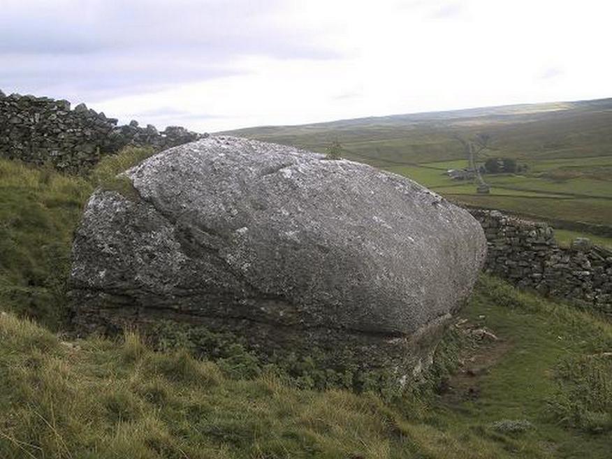
From the small town of Bainbridge, head south down the Carpley Green Road. Less than a mile before the end, look to the west-facing slope of Addlebrough Hill and this huge Devil’s Stone can be seen resting halfway up the slope, just by the wall. Y’ can’t miss it!
Archaeology & History
The Devil’s Stone
Highlighted on the 1856 Ordnance Survey map, one of the legends of this place suggested there might be cup-and-ring markings on the stone, but the curious markings on top of the rock seem to be natural. It’s a superb stone though, dropped here no doubt by some great glacier as it retreated north, in ages truly olde…
There’s a lot of archaeology around here that’s yet to receive the attention of the archaeology textbooks. But if you’ve ventured to see this, have a gander across to the massive prehistoric tomb known as Stony Raise, less than a mile southeast of here.
Folklore
One legend tells that long ago Addlebrough was the home of a great unnamed giant — but a friendly giant by all acounts. However, one day the devil turned up and wanted possession of the giant’s hill and so a fierce row broke out between them. Perched on the top of the crag — which is the rough ridge to the west of here — the giant who lived there hurled huge boulders down at the devil, but they fell short and landed at the side of Lake Semerwater (itself an important spot in local prehistory). In return, Old Nick himself began throwing boulders back — and one of those which the devil threw landed here, halfway up the western flank of Addlebrough Hill (a couple of the large boulders which the giant threw can be seen on the edge of Semerwater and are known as the Carlow and Mermaid stones). Hence it’s name of the Devil’s Stone!
In Edmund Bogg’s Richmondshire (1908), he told how, “the curious markings on (the Devil’s Stone) are accounted due to the pressure of the devil’s fingers” which were caused when he threw this giant stone from somewhere to here.
Site shown on 1856 map
This is a theme we find at countless other stone sites, i.e. the Devil burning holes into rock — and in some cases these devil’s “fingerprints” have turned out to be prehistoric cup-markings. Such tales relate to the pre-christian Creation Myth of a place and would, before the “devil” was supplanted onto a site, have had wider significance in the landscape as a whole, in a manner known only to local people. Devils usually replaced legendary giants, or the hero-figures who created the land in primordial times in the myths of our ancestors. A greater examination of the nearby sites in association with the folklore of the region would no doubt be quite profitable…
References:
Bogg, Edmund, Richmondshire, James Miles: Leeds 1908.
Romney, Paul (ed.), The Diary of Charles Fothergill, 1805, Yorkshire Archaeological Society: Leeds 1984.
Standing Stone (lost): OS Grid Reference – SU 161 432
Archaeology & History
In William Stukeley’s Stonehenge, he described a number of monoliths outlying Salisbury Plain that also possessed a prehistoric pedigree. Most of them have been recorded, but this one seems to have been forgotten about — perhaps by virtue of it having fallen into the River Avon! Edgar Barclay (1895) described it in his fine survey, saying:
“In the bend of the river below the village, is a large submerged stone; only during drought is any portion of it visible above water; it can, however, in ordinary times, be dimly seen from the bank, which is of chalk, here very steep and overgrown. The country people assert that a metal ring, “turning always,” is let into its upper end. Legend relates that when the Devil brought the rocks of Stonehenge from Ireland, tied together with withes, this stone escaped from the bundle and fell into the river. Its position forbids the belief that it got fixed in the bed of the stream when its passage to Stonehenge was being attempted, for it lies immediately beneath the crest of a very steep bank, and at its most inaccessible point; as the stream sweeps against this, the water must always have been deep at this spot, the open valley would everywhere offer more favourable points for such an operation, especially would this be the case before the Avon was dyked. A boundary stone would have been placed on the brow of the hill; if the stone be a grey-wether, as report says, and as is probable, it may originally have stood on the bank, and “once upon a time”, a ring having been fixed in it, it may have been dragged into the stream to moor a ferry-boat. It lies closely midway between the stone on Bulford Down and that in Durrington fields.”
One wonders if any local people might know more about this…
References:
Barclay, Edgar, Stonehenge and its Earth-works, D. Nutt: London 1895.
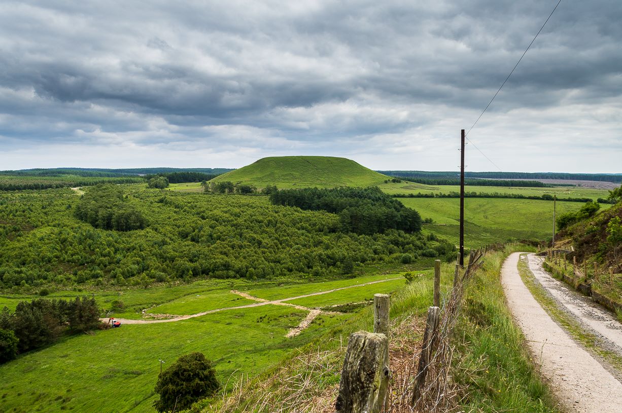
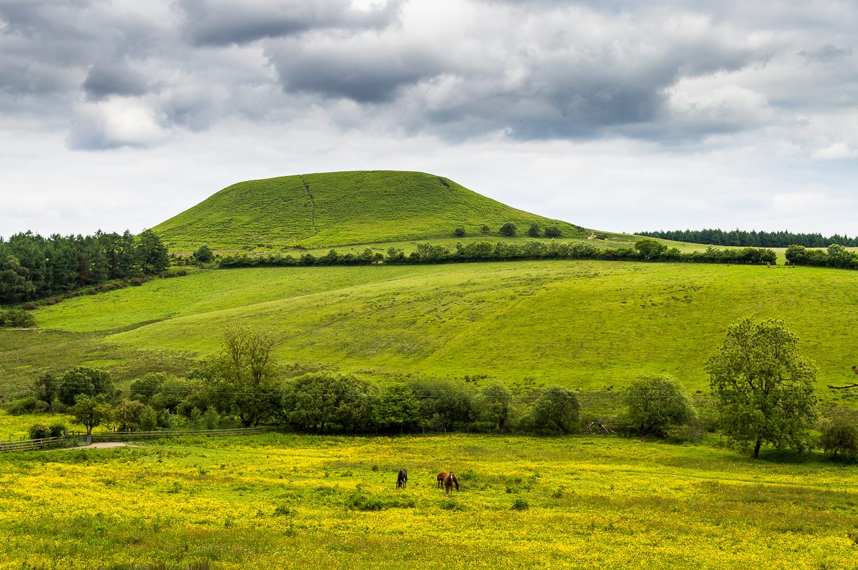
From Pickering, take the A169 towards Whitby. When you get to the Car Park at the ‘Hole-of-Horcum’ – (you can’t miss it), park the car and walk North along the side of the road towards Whitby. After 60 yds, take the track East. Follow this for approximately a mile until the track splits. Take the concrete track left towards the farmhouse of ‘Newgate Foot’. Go through the yard past the house on the right, and you will come to a stream and a gate and there, ahead of you, rises Blakey Topping…
Archaeology & History
The giant hill of Blakey Topping was recorded as early as 1233 CE and in a simplistic style just means the ‘black mound’; but this derivation has additional ingredients, implying it as a ‘black meeting-place’ or moot. Black in the etymological sense also implies ‘shining’ and it may also relate to the northern airt of black (meaning death, darkness, north, etc), when you’re stood at the ruined stone circle 400 yards to the south. But I’m speculating here…
Several 19th century antiquarians suggested there may have once been a cairn on top of the hill, but others who’ve explored this idea seem to have put it to bed.
Folklore
This great hill is well recognised amongst local people and, to this day, its animistic creation myths and other folklore elements are still spoken. When the photographer James Elkington recently visited the nearby standing stones, he bumped into the old farmer who told him how his father had seen the faerie-folk on the hill many years back. And its modern reputation as a gorgeous site adds to such lore, which dates way back.
In Frank & Harriett Elgee’s (1933) archaeology work, they narrated the old creation myth that local people used to tell of this great hill,
“A witch story related by a native 25 years ago attempts to explain two conspicuous natural features two miles apart on Pickering Moor; Blakey Topping, an isolated hill, and the Hole of Horcum, a deep basin-shaped valley. The local witch had sold her soul to the devil on the usual terms, but when he claimed it, she refused to give it up, and flew over the moors, with the devil in hot pursuit. Overtake her he could not, so he grabbed up a handful of earth and flung it at her. he missed his aim and she escaped. The Hole of Horcum remains to prove where he tore up the earth and Blakey Topping where it fell to the ground.
“From our point of view the significance of this story lies in the fact that between the Hole and the Topping there is a Bronze Age settlement site at Blakey Farm, with its stone circle. The rough trackway leading from the Hole to the circle is known as the Old Wife’s Way, presumably also marking the witch’s flight. This, together with other Old Wife’s Ways, preserves as it were Bronze Age church tracks”.
Looking up from the SW (James Elkington)
A relative variation on this tells that the Hole of Horcum was made by the local giant, Wade. He was having a row with his wife, Bell, and got so angry that he scooped out a lump of earth and threw it at her. The huge geological feature known as the Hole of Horcum is the dip left where he scooped out the earth, and Blakey topping, the clod itself, resting in situ where it landed. A christian appropriation of the story replaces Wade and his wife with their ‘devil’: a puerile element unworthy of serious consideration.
In more recent times, the old geomancer Guy Ragland Phillips (1976; 1985) found that a number of alignments, or leys (known as a ‘node’), centred on Blakey Topping: twelve in all, reaching out and crossing numerous holy wells, prehistoric tumuli, standing stones, etc. The precision of the alignments is questionable, yet the matter of the hill being a centre-point, or omphalos, would seem moreso than not.
References:
Elgee, F. & H.W., The Archaeology of Yorkshire, Methuen: London 1933.
Phillips, Guy Ragland, Brigantia, RKP: London 1976.
Phillips, Guy Ragland, The Unpolluted God, Northern Lights: Pocklington 1987.
Smith, A.H., The Place-Names of the North Riding of Yorkshire, Cambridge University Press 1928.
A few hundred yards below the legendary old Wizard’s Stone, we find there’s a real cluster of witch-lore in the small area to the north of Dollar which, to be honest, is deserving of wider analysis from competent researchers and historians. Not only is there the legendary Lochy Launds of the Black Goddess hereby, but we also find this curious rock, described by one ‘J.C.’ in an early edition of the Scottish Journal (1848), which told:
“On the confines of the parish of Dollar, not far from Hillfoot, the seat of John McArthur Moir, Esq., lies a glen, called Burngrens, watered by a small stream and planted with numerous large trees. A great number of these, however, have fallen, during the last few years, beneath the unsparing axe; but strong, healthy saplings are rising rapidly to supply their place.
“In this glen there is a large stone, of peculiar formation, in every way like a cradle. It is currently believed by the superstitious in the vicinity, that the stone, every Hallowe’en night, is raised from its place, and suspended in the air by some unseen agency, while “Old Sandy,” snugly seated upon it, is swung backwards and forwards by his adherents, the witches, until daylight warns them to decamp.
The following rather curious affair is told in connection with the “Cradle:”
“One Hallowe’en night a young man, who had partaken somewhat freely of the intoxicating cup, boasted before a few of his companions that he would, unaccompanied, visit the stone. Providing himself with a bottle, to keep his courage up, he accordingly set out. The distance not being great, he soon reached his destination. After a lusty pull at the bottle, he sat down upon the “Cradle,” boldly determined to dispute the right of possession, should his Satanic majesty appear to claim his seat. Every rustle of a leaf, as the wind moaned through the glen, seemed to our hero as announcing the approach of the enemy, and occasioned another application to fortifying “bauld John Barleycorn.” Overpowered at last by repeated potations, our hero, dreaming of “Auld Nick,” and his cohort of “rigwuddie hags,” fell sound asleep upon the stone.
“His companions, who had followed him, now came forward. With much shouting and noise, they laid hold of him, one by the head and another by the feet, and carrying him, half-awake, to the burn, dipped him repeatedly, accompanying each immersion with terrific yells. The poor fellow, thinking a whole legion of devils were about him, was almost frightened to death, and roared for mercy so piteously that his tormentors thought proper to desist. No sooner had our hero gained his feet than he rushed up the glen, and ran home, resolving never to drink more, or attempt such a feat again. For many a long day he was ignorant who his tormentors really were.
“We stood upon the stone about a week ago. Ivy and moss are slowly mantling over it, a proof that it is some considerable time since the Devil has been rocked on it.”
Historian Angus Watson (1995) told the place to be “south of Wizard’s Stone…near Kelty Burn,” and also that,
“it is said to be where witches rock Satan to sleep on Halloween.”
Above here, the tree-topped rounded hill to the north was one of the meeting places of the witches of Fife, Perthshire and Clackmannan. Something of sincere pre-christian ritual importance was undoubtedly enacted in this region, as we also find sites of the Maiden a short distance due north. Does anyone know more about this fascinating sounding place?
References:
‘J.C.,’ “The Deil’s Cradle”, in The Scottish Journal, February 5, T.G. Stevenson: Edinburgh 1848.
Simpkins, John Ewart, County Folklore – volume VII: Examples of Printed Folk-Lore Concerning Fife, with some Notes on Clackmannan and Kinross-Shires, Folk-Lore Society: London 1914.
Watson, Angus, The Ochils: Placenames, History, Tradition, PKDC: Perth 1995.
Take the road from Fortingall into the Glen. About 4 miles down, past the farmhouse of Slatich, then Craigianie, watch carefully as you round the small bend in the road, where you’ll see a small standing stone on top of a rounded mound, right by the south side of the road, just over the fence. Go through the gate to enter the field less than 100 yards further on and walk back onto the hillock.
Archaeology & History
In this magnificent landscape down the longest of Scotland’s glens, standing atop of a knoll known as Tom a’ Mhoid, or “the moot hill” (Watson 1926), is this small standing stone about 4 feet tall which has long been ascribed as an important relic of the early christian period. They may be right – but it could as much be a more archaic monolith, onto which the carved crosses on either side of the stone were later etched, in the light of the myths of St. Adamnan whose name scatters this great glen and after the legend cited below was ascribed to him.
Close-up, showing large cross
The stone ‘cross’ stands atop of what at first sight seems a natural knoll; but all round it we find an excess of man-made remains and walling, all but constituting the hill itself. These are clearly visible on the aerial imagery of GoogleEarth. Antiquarian dogs here would be invaluable to ascertain the correct age and nature of the structures around this ‘cross’.
Faint cross near top of stone
Of the crosses carved onto the stone: the one on the southern face is a small faint one near the top of the upright; whilst the other is much larger and is easily visible, cutting right across the northern face of the monolith. They are clearly of differing styles and would seem to have been carved by different people, perhaps a few centuries apart. Curiously—as Marion Woolley pointed out—the smaller, fainter cross is carved above a ridge on the upright stone, mimicking the position of the stone on the knoll in its landscape setting. Whether this is just a coincidence, or has been done on purpose, we might never know.
In Duncan Fraser’s (1969) excellent local history work, he names the stone here Eonan’s Cross and he too strongly suspects “the stone itself was probably erected at least a thousand years earlier” than the coming of the saint, making this a christianized standing stone – which it certainly looks like. Mr Fraser said that,
“His cross stone, we can be fairly sure, was a Bronze Age standing stone long before it acquired its unusual cross.”
He may well be right…
Folklore
The mythic history of this cross-marked standing stone was told eloquently in one of Hilary Wheater’s (1981) fine short works. After giving a brief story of the tale of St. Adamnan, she went on to tell:
“A terrible plague swept through Scotland in the seventh century. It reached the Vale of Fortingall and so violent was its ravages that all the inhabitants were wiped out. Slowly the sickness began to infiltrate the Glen and in a panic the people of Glenlyon went to their preacher and beseeched him, “Eonan of the ruddy cheeks, rise and check the plague of thy people. Save us from the death and let it not come upon us east or west.”
“Adamnan rose to the occasion and gathered the people of the Glen to a hillock where he usually preached to them. In a house not forty yards away it is said that a child was already dying of ‘the Death.’
“There on the rock, with the people gathered round him, Adamnan prayed. When he was finished he raised his right arm, exhorted the devil body of the pestilence to come to him and, pointing to a large round rock lying on the ground, ordered the plague to enter it. A large circular hole appeared in the rock as the plague bored into it and Adamnan followed up this apparent miracle by the very sensible act of sending all the healthy people of the Glen up to the shielings until all signs of the pestilence disappeared…
“Thus were the people of the Glen saved from the plague. When they came back from their mountain retreat they erected a stone slab with two crosses on it to commemorate their deliverance. The rock itself they called Craig-diannaidh, the ‘rock of safety’, and the round stone with the hole through which the plague descended into the bowels of the Earth lies to this day at the side of the road near the stone slab.”
Adamnan’s Cross
The rocky slope immediately above the stone, on the other side of the road, was once the home of an old urisk who, sadly, long-since left the area – though his spirit can still be felt there. Accounts of many other supernatural creatures are found scattering this part of Glen Lyon…
References:
Barnett, T. Ratcliffe, The Road to Rannoch and the Summer Isles, Robert Grant: Edinburgh 1924.
Fraser, Duncan, Highland Perthshire, Standard Press: Montrose 1969.
Watson, W.J., The history of the Celtic Place-Names of Scotland, Edinburgh 1926.
Wheater, Hilary, Aberfeldy to Glenlyon, Appin: Aberfeldy 1981.
ACKNOWLEDGEMENTS: Massive thanks to Marion—”I don’t have a clue where I am!”—Woolley, for getting us here….and for her photo of the faint cross, above.
Carlie Craig is the tree- covered cliff, centre of photo
If you’re coming from Blairlogie, a half-mile west of the village, take the B998 road to the university, but turn right up the first road that runs uphill into the trees. But if you’re coming from Stirling or Bridge of Allan, keep your eyes peeled for the barely visible B998 at the crossroads and go up the hill, and along, for a good mile, below the Uni, past the factory, then up the small road on your left. Up this road go past the church another 100 yards and you’ll see the derelict ruins of Logie Kirk on your right. Right above the ruin you’ll see the tree-lined cliff immediately behind. This is the Carlie Craig!
Folklore
Carlie Craig on the 1862 map
The tree-covered Carlie Crags above the old ruined church and graveyard of Logie Kirk immediately below (thought to have been built in 1684) has long been associated with legends of old witches. Deriving its name from ‘carlin’, a witch or old woman (cailleach), the Crags were traditionally the place of heathen rites (authentic ones, not your plastic pagan types). In David Morris’ (1935) essay on the local township, he told the common story that “an elder in Logie Kirk was of the opinion that the Carla’ Craig…was haunted.” At the end of the 19th century, Morris remembered a local lady known as ‘Ailie’, who was said by many old folk to be the traditional “witch of Logie.”
“Sickly children were brought to her for her blessing. Occasionally people came from as far as Stirling on this errand. Her method of giving the blessing was to blow her breath on the child, and this was supposed to ward off evil. It was also said that anyone buried in Logie Kirkyard on the first day of May, Hallowe’en, or other days of that kind, without her blessing, would not rest in his grave…”
Another legend told that,
“around 1720 witches were believed to rendezvous with the Evil One (i.e. the devil) who would appear in the form of a large black dog.”
A lengthier account of the belief in witchcraft and animistic pre-christian rites above the crags was told by Charles Rogers (1853):
“About the second decade of last century, there lived in the parish of Logie several ill-favoured old women, to whom the reputation of witchcraft was confidently attached. They were believed to hold nocturnal dialogues and midnight revels with the Evil One, and Carlie Crag was regarded as one of their places of rendezvous. Satan, though he was believed to appear to them in various forms, was understood, in his interviews with the dreaded sisterhood, to appear most frequently in the aspect of a large shaggy dog, in which form it was alleged he had repeatedly been seen by the minister. An elder of the kirk had been returning of an evening from a shooting excursion among the hills, with a trusty musket, which he had picked up some years before on the field of Sheriffmuir, and discovering on the top of Carlie an animal realizing the description of the Satanic mastiff, resolved to try upon it the effects of a shot. He knelt down cautiously near the foot of the crag, and after ejaculating a short prayer, and slipping into his musket a silver coin, fired with trembling heart but steady aim. His victim, evidently shot dead, tumbled to the base, and the delighted and astonished elder lost no time in personally communicating to the minister the success of his wonderful adventure. Though not a little superstitious, the minister was somewhat sceptical as to the mysterious dog being really dead. He however agreed to accompany his elder next morning to the foot of the crag to inspect the carcase; but on reaching the spot, they found the remains of no shaggy dog or evil genius, but the lifeless form of the beautiful pet goat of a poor and aged woman, a much respected parishioner. The minister and elder both shed tears. The wicked dog still lived, the innocent goat had perished. The elder however took credit to himself for his good intentions and valorous intrepidity ; and the minister deemed it proper to improve the subject in his pulpit prelections on the following Sabbath. Discoursing on the subject of resistance to the Devil, he remarked, that the Evil One might assume numerous shapes and forms; that he went about as a roaring lion was declared in the Word, but he might take to himself various other aspects. He might even appear as a black colley dog.” But whatever form he may assume,” added the minister, ” he cannot be overcome or destroyed by powder and shot. There is a gun, however, that will shoot him, and it is this — it is the Bible. Shoot him then, every one of you, with this gun, and he shall be shot.”
Whether the vicar’s biblical superstitions were adopted by local people—who were so much more used to the living animism of landscape and natural cycles—is questionable. The crag is a fine site for ritual magick and its associative devil-lore probably derives from Pictish shamanistic practices, remains of which are evident across the Scottish hillls and northern England, where they survived for some considerable time…
References:
Morris, David, B., “Causewayhead a Hundred Years Ago”, in Transactions of the Stirling Natural History and Archaeological Society, 1935.
Roger, Charles, A Week at Bridge of Allan, Adam & Charles Black: Edinburgh 1853.
Watson, Angus, The Ochils – Placenames, History, Tradition, Perth & Kinross District Libraries 1995.
Tumulus (destroyed): OS Grid Reference – SE 426 634
Also Known as:
Deuill Cross Hill
Devil’s Cross
Urn from Devil’s Cross tumulus
Archaeology & History
In Henry Smith’s wonderful Reliquiae (1852) on the history of Aldborough and district, this intriguingly named but forgotten site is given the greatest literary attention extant. Assumed by a couple of modern academics – without evidence – to have been little more than a natural hillock, this once great mound was undoubtedly an important burial place for some ancestral characters. Although its exact location is unknown (anyone out there know for certain?), it was said to have been located about 100 yards from where the old tracks crossed at Duel Cross.
First described by a Mr Urban in the Gentleman’s Magazine of June, 1787. He told it to be known as the Devil’s Cross and was a tumulus,
“whose elevation is about 18 feet, and circumference at the base 370 feet. It was broken into some time since to supply materials for the repair of the high road leading from Aldborough to York. The soil consists, first, of a black earth, and under that a red sandy gravel, human bones, some of which are entire, and urns of various sizes. The urns are composed of blue clay and sand, some ornamented and others quite plain; several Roman coins have also been found here.”
There were a great number of old urns found in the mound when it was dug into in 1756, leading Mr Urban to believe the site was used an ancient cemetery. Intriguingly he told that all of the urns and their ashes were found to have been placed on one side of the mound, with many human bones being deposited in another section, away from the urns. This, the finding of Roman coins next to the mound and the proximity of the Roman road led Mr Urban to believe the site was a Roman tumulus, though this seems unlikely. Years later, Henry Smith’s (1852) commentary on the Devil’s Cross hill led him to believe the mound was from a much earlier period:
“From a sketch of one of these, which is stated to have been nine inches high, there can be little doubt of these cinerary urns bring of the ancient British period, but from the great number of bones discovered, this tumulus was probably used as a cemetery during the Romano-British period, if not still later. Of its use in Roman times, evidence is unequivocally supplied in the numerous coins found here…”
Carved stone figure (from Smith’s ‘Reliquiae’)
Not far from this long lost tumulus, a curious carved stone figure was located “among ancient foundations” in a cellar! Thought to be a local deity, it may have been a carved representation of whichever figure or spirit ancestor was buried in Duel Cross Hill — though we’ll never know for sure.
Folklore
Although archaeologically, etymologically and geomantically related to the nearby Devil’s Arrows at Boroughbridge a couple of miles up the road, there is nothing specific I can find of this once important tumulus. However the place-name in both forms, Deul and Deuill, refers to the pre-christian devil (from deofol, Old English, “devil”). This name may relate to the stone figure shown in the illustration, or of long lost heathen rites enacted here in bygone times. Any further info on this place is very welcome.
References:
Hargrove, E., The History of the Castle, Town and Forest of Knaresbrough, Hargrove & Sons: Knaresbrough 1809.
Smith, Henry E., Reliquiae Isurianae, J.R. Smith: London 1852.
This curious rounded boulder sitting outside the parish church was described by Alexander Polson in his survey of witch-lore. He told us that “when the old church was being built, the devil, as a mason out of work, came here and was employed.” But it wasn’t long before a local christian discovered his disguise and, uttering some magickal biblical words, the devil became furious.
“Immediately he heard this there was a clap of thunder and the fiend flew away to the Isle of May,” about five miles away to the south. “Here in his anger he seized a huge rock and hurled it at the church. It fell quite near, did no harm, and a part of it lay at the church’s door, with the mark of the devil’s thumb on it.”
On the north end of the Isle of May are the Altar Stanes (NT 652 997), thought to have been where the devil stood (close to the holy well of St. Andrew [NT 652 994]) and threw this stone at Crail several miles north. In pre-christian mythic terms, north is the direction or airt of greatest symbolic darkness. A variation on the creation myth for this stone tells that when it was thrown from the island, one half of it split off and it fell by the coast in Balcombie, Fife.
References:
Polson, Alexander, Scottish Witchcraft Lore, W. Alexander: Inverness 1932.
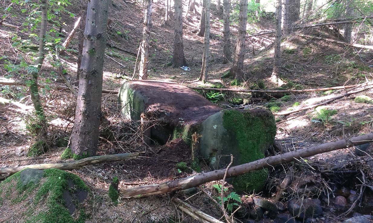
When Pete Glastonbury brought us here, we walked east out of the Avebury stone circle and up the Wessex Ridgeway track. When you hit the “crossroads” at the top of the rise a mile along, go across the stile into the grasslands for a few hundred yards till you hit the obviously-named “Gallops” racecourse-looking stretch. Walk down for a few hundred yards till you hit a footpath on your left that takes you across and down grasslands that takes you slowly into the valley bottom. You’re damn close!
Otherwise (and I aint done this route!), walk up the footpath straight north from Clatford village, up the small valley for about 1km. You’ll eventually see this great stone heap in the field on your left!
Archaeology & History
I was brought here one fine day last year in the company of PeteG (our guide for the day), Geoff, June and Mikki Potts. Twas a fine foray exploring the various prehistoric sites on the lands east of Avebury — but it was my very first venture to this site, the Devil’s Den — and a grand one it was indeed! Standing close to the small valley bottom a couple of miles east of the great stone circle, this megalithic monument is thought to be neolithic in origin.
When H.J. Massingham (1926) came here, the day and spirit of the place must have felt fine, as he described,
“its three uprights and capstone stand forlornly in the midst of an alien sea of ploughland swinging its umber ripples to the foot of a stone isle, drifted nearly four thousand years from the happy potencies of its past.”
And, on many good times here no doubt, for many people, such feelings still hold…
A.C. Smith’s Devil’s DenColt Hoare’s Devil’s Den
It was described by the President for the Council of British Archaeology, Paul Thomas (1976), “as a setting of four sarsen uprights with a capstone”, whereby four uprights have not been noticed here since very early times. Not sure how old he was though! Today the very large capstone weighing upwards of 20 tons rests gently upon just two very bulky upright monoliths. A third is laid amidst the great tomb , overgrown and sleepy, touching one of the two uprights….
The cromlech itself seems to have once been part of a lengthy mound that was covered in earth, “about 230ft long and 120ft broad, now virtually removed by ploughing.” On top of the great capstone are at least two cup-markings: one of them with a possible oval-shaped line carved out onto the edge of the rock (similar to the C-shaped carving on the nearby Fyfield Down cup-marked stone), but this needs looking at in various lights so we can ascertain whether it has a geological or artificial origin.
Stukeley’s Devil’s Den
Suggested by Edwin Kempson (1953) and also by Aubrey Burl (2002) and other dialect and place-name students to have originally been called Dillion Dene — “the boundary marker in the valley” — this collapsed chambered tomb has had many literary visitors, from William Stukeley onwards. When the reverend Smith wrote his great tome in 1885, he gave an assessment of those who came before him, saying:
“This is a noble specimen of the Kistvaen: it stands erect in its original position, only denuded of the mound of earth which, I venture to say (on the authority of the Rev. W.C. Lukis and others best acquainted with these remains) at one time invariably covered them: and this massive erection of ponderous stones is known as the ‘Devil’s Den’, and offers an exceedingly fine specimen of the kistvaen to those who have not made the acquaintance of these ancient sepulchres in other counties. It is not only perfect in condition, but of very grand dimensions; moreover, it is well known to everybody who takes the slightest interest in Wiltshire antiquities… Stukeley says very little of this kistvaen, though he gives several plates of it (in Abury Described), his only remark being: “An eminent work of this sort in Clatford Bottom, between Abury and Marlborough.” Sir R. Hoare (in Ancient Wiltshire, North) is more enthusiastic, he says: “From Marlborough I proceed along the turnpike road as far as the Swan public house in the parish of Clatford, and then diverge into the fields on the right, where, in a retired valley amongst the hills, is a most beautiful and well-preserved kistvaen, vulgarly call’d the ‘Devil’s Den.’ It has been erroneously described as a cromlech. From the elevated ground on which this stone monument is placed, it is evident that it was intended as a aprt annexed to the sepulchral mound, and erected probably at the east end of it, according to the usual custom of primitive times.””
In more recent years, Terence Meaden (1999) has suggested that the Devil’s Den may actually have been a simple cromlech and never had any covering mound of earth. In his Secrets of the Avebury Stones he described how,
“The vertical megaliths must have been set up firmly first and then, quite possibly, a mound was raised outside and between them. A very long ramp could have been built next, along which the capstone was dragged until it lay on top of the vertical monoliths, after which both mound and ramp would be removed as far as possible. Such an operation, if correct, would explain why the stones of Devil’s Den now stand on an obviously artificial eminence; and why the much-spread remains of a long mound oriented NW-SE, about 70 metres (230 feet) long and 40 metres (130 feet) broad, were seen and described by Passmore in 1922. One should not necessarily assume that the stones are the remains of a chambered long barrow, although they might be.”
And you’ve gotta say that unless we have hardcore evidence to the contrary, his summary is quite possible. However, it seems here that Meaden has simply utilised this logic to enable him to posit another reason — a “good one” he calls it — for this suggestion, i.e.,
“its capstone seems to have profiles of heads carved upon two, perhaps three of its sides; suggesting that, if the art was meant to be seen, the capstone was never covered with earth.”
Devils Den on 1889 map
Unfortunately however, these possible “carved heads” on the sides of the capstone more typify Rorscharch responses to natural geological shapes scattering rocks all over the planet. Up North, if we were to attempt this sorta suggestion, we’d have millions of such carved heads popping up all over the place. It’s a nice idea, but somewhat unlikely.
Folklore
The old dowser Guy Underwood (1977) was renowned for locating water lines* in and around many of England’s prehistoric sites, and the same pattern was recorded here. He told that the Devil’s Den marked the site of a blind spring “of exceptional importance.” He continued:
“The Devil’s Den dolmen marks the source of a multiple water line which forms a maze, marked by stones, about 200 yards to the northwest. It terminates at a well, where two tracks cross about a mile further west. This site is likely to have had special sanctity and would be interesting to excavate.”
Whilst the importance of water was understandable in ancient days, some other folklore attributes derive from quite different ingredients. The common theme of “immovability” is found here, as described by reverend Smith (1885) again who, amidst other peculiarities, told the following:
“There are various traditions connected with it. I was told some years since, by an old man hoeing turnips near, that if anybody mounted to the top of it, he might shake it in one particular part. I do not know whether this is the case or not, though it is not unusual where the capstone is upheld by only three supporters. But another labourer whom I once interrogated informed me that nobody could ever pull off the capstone; that many had tried to do so without success; and that on one occasion twelve white oxen were provided with new harness, and set to pull it off, but the harness all fell to pieces immediately! As my informant evidently thought very seriously of this, and considered it the work of enchantment, I found it was not a matter for trifling to his honest but superstitious mind; and he remained perfectly unconvinced by all the arguments with which I tried to shake his credulity.”
References:
Burl, Aubrey, Prehistoric Avebury, Yale University Press 2002.
Goddard, E., “The Devil’s Den, Manton, Wiltshire,” in The Antiquaries Journal, volume 2, no.1, January 1922.
Gomme, Alice B., ‘Folklore Scraps from Several Localities’, in Folklore, 20:1, 1909.
Grinsell, Leslie V., Folklore of Prehistoric Sites in Britain, David & Charles: London 1976.
Kempson, E.G.H., “The Devil’s Den,” in Wiltshire Archaeology & Natural History Magazine, 55, 1953.
Massingham, H.J., Downland Man, Jonathan Cape: London 1926.
Meaden, Terence, The Secrets of the Avebury Stones, Souvenir Press: London 1999.
Smith, A.C., A Guide to the British and Roman Antiquities of the North Wiltshire Downs, Wiltshire Archaeological & Natural History Society 1885.
Thomas, Nicholas, Guide to Prehistoric England, Batsford: London 1976.
Underwood, Guy, The Pattern of the Past, Abacus: London 1977.
Wright, Joseph, English Dialect Dictionary – volume 2, Henry Frowde: London 1898.
* Those people who allege they can dowse will always find water in their first few months, if not years, of sensitivity. There is a pattern nowadays of people using dowsing tools and, when the rods cross (or whichever accessory they get their reactions from), they allege they are connecting with unknown energies, ley lines and other such items; but this is simply incorrect. The primary dowsing response is water (life-blood) and it takes much practice over long periods of time to even begin isolating leys or other occult phenomena.
Plenty of ways of approaching this huge fella! Personally, I’d take it from the steep valley immediately east and north where the ramparts drop you down the hill, if only to get a decent idea of the scale of the thing! But those of you into taking it easy can do no better than take the country road south out of Poynings village (towards Brighton), down Saddlescombe Road, for just under a mile, where you should take a right-hand turn along the Summer Down lane for a mile. You’ll then hit the Devil’s Dyke Road. Turn right here and go to the end. You’re right in the middle of it!
Archaeology & History
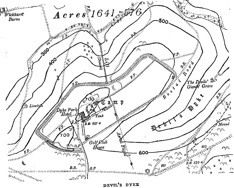
Early plan of Devil’s Dyke ‘camp’
Although most of this huge monument hasn’t been given the investigation it deserves — hence making knowledge of its origins more speculative than factual — as Jacquetta Hawkes (1973) wrote, seemingly all those years ago now, “it is known that a village lying half in and round them was occupied in the Belgic period at the end of the Iron Age.” And it’s certainly big enough! The encircling circuit of dykes themselves stretch all the way round a distance of more than 2150 yards long (that’s 1.22 miles, or 1.97km!), with the longest east-west axis being more than half-a-mile across.
Nowadays it seems, the Devil’s Dyke is the name given to the steep valley below the encampment, but a hundred years back it was the camp itself that was known by this name. Described by the wandering antiquarian R. Hippisley Cox (1927) as “a camp containing forty acres (with) very steep and difficult approaches,” another early account in The Antiquaries Journal — commenting on a ground-plan of the site from the Brighton and Hove Herald of 1925 — told:
“The heavy encircling lines represent ramparts, and the thin line marks the outer margin of the accompanying ditch. A spur renders the earthwork weakest on the south-west, and the rampart is therefore highest between the points 1 and 3, rising 21ft vertically above the ditch, which is nearly filled up at the present time. On the north-west there is steep slope outside the camp, and the ramparts are considerably lower, the iner ditch being nearly obliterated. The outer rampart is now wanting betwen 7 and 8, but this inner one becomes stronger as the outer slope of the ground decreases, only to die away again on the south-east where the camp overlooks the steep Dyke Valley. A double-bank and inner ditch can still be traced from the north-east angle to a point near the old golf-club house.”
I first came here as a young lad and the site was lost on me (in them days, if monuments weren’t stiff and upright, I really didn’t see the point!). These days however, the size of it alone blows you away somewhat.
Folklore
As you’d expect the creation myths of this site and its edges relate to our old heathen friend, the devil! The landscape itself was, in old lore, the work of the devil (though prior to this, the devil was known in peasant-lore to be a legendary giant, though I am unaware of the name/s of the giant in question); and the great valley below the Devil’s Dyke encampment was actually dug out by Old Nick in the old tales. That old folklorist Jacqueline Simpson (1973) takes up the story:
“The Devil…had been infuriated by the conversion of Sussex, one of the last strongholds of paganism in England, and more particularly by the way the men of the Weald were building churches in all their villages. So he swore that he would dig right through the Downs in a single night, to let in the sea and drown them all. He started just near Poynings and dug and dug most furiously, sending great clods of earth flying left and right — one became Chanctonbury, another Cissbury, another Rackham Hill, and yet another Mount Caburn. Towards midnight, the noise he was making disturbed an old woman, who looked out to see what was going on. As soon as she understood what he was up to, she lit a candle and set it on her window-sill, holding up a sieve in front of it to make a dimly glowing globe. The Devil looked round, and thought this was the rising sun. At first he could hardly believe his eyes, but then he heard a cock crowing — for the old woman, just to make quite sure, had knocked her cockerel off his perch. So Satan flew away, leaving his work half done. Some say that as he went out over the Channel, a great dollop of earth fell from his cloven hoof, and that’s how the Isle of Wight was made; others, that he bounded straight over into Surry, where the impact of his landing formed the hollow known as his Punch Bowl.”
That’s the story anyway — take it or leave it! Of importance in this fable is the figure of the “old woman”: a much watered-down version of the cailleach figure of more ancient northern and Irish climes, where tales of her doings are still very much alive. And many are the tales of her battles with other giant figures, just as we evidently once had here.
Ghosts have been reported by local people upon this hill-top site; and there are a number of other folktales to be found here…which I’ll unfold over time as the months pass by…
References:
Anon., “Notes: The Brighton Dyke,” in The Antiquaries Journal, 5:4, October 1925.
Clinch, G., “Ancient Earthworks,” in Victoria County History of Sussex – volume 2 (edited by W. Page), St. Catherine’s Press: London 1905.
Cox, R. Hippisley, The Green Roads of England, Methuen: London 1927.
Hawkes, Jacquetta, A Guide to the Prehistoric and Roman Monuments in England and Wales, Chatto & Windus: London 1973.
Hogg, A.H.A., “Some Aspects of Surface Fieldwork,” in The Iron Age and its Hillforts (edited by M. Jesson & David Hill), Southampton University Archaeology Society 1971.
Simpson, Jacqueline, The Folklore of Sussex, Batsford: London 1973.
Simpson, Jacqueline, “Sussex Local Legends,” in Folklore Journal, volume 84, 1973.


")
")

")