Take the B6362 high road between Lauder and Stow and, regardless of which direction you’re coming from, when you reach the top heights of the moorland road with views all around, you need to keep your eyes peeled for where a dirt-track runs south and, diagonally across the road on its north side, is a dirt-track-cum-parking-spot (if you came from Stow, you should’ve already noticed the cairn on the skyline on your way up). There’s a hut circle in the heather by the parking spot. From here, just walk over the heather nearly 300 yards north. Y’ can’t really miss it.
Archaeology & History
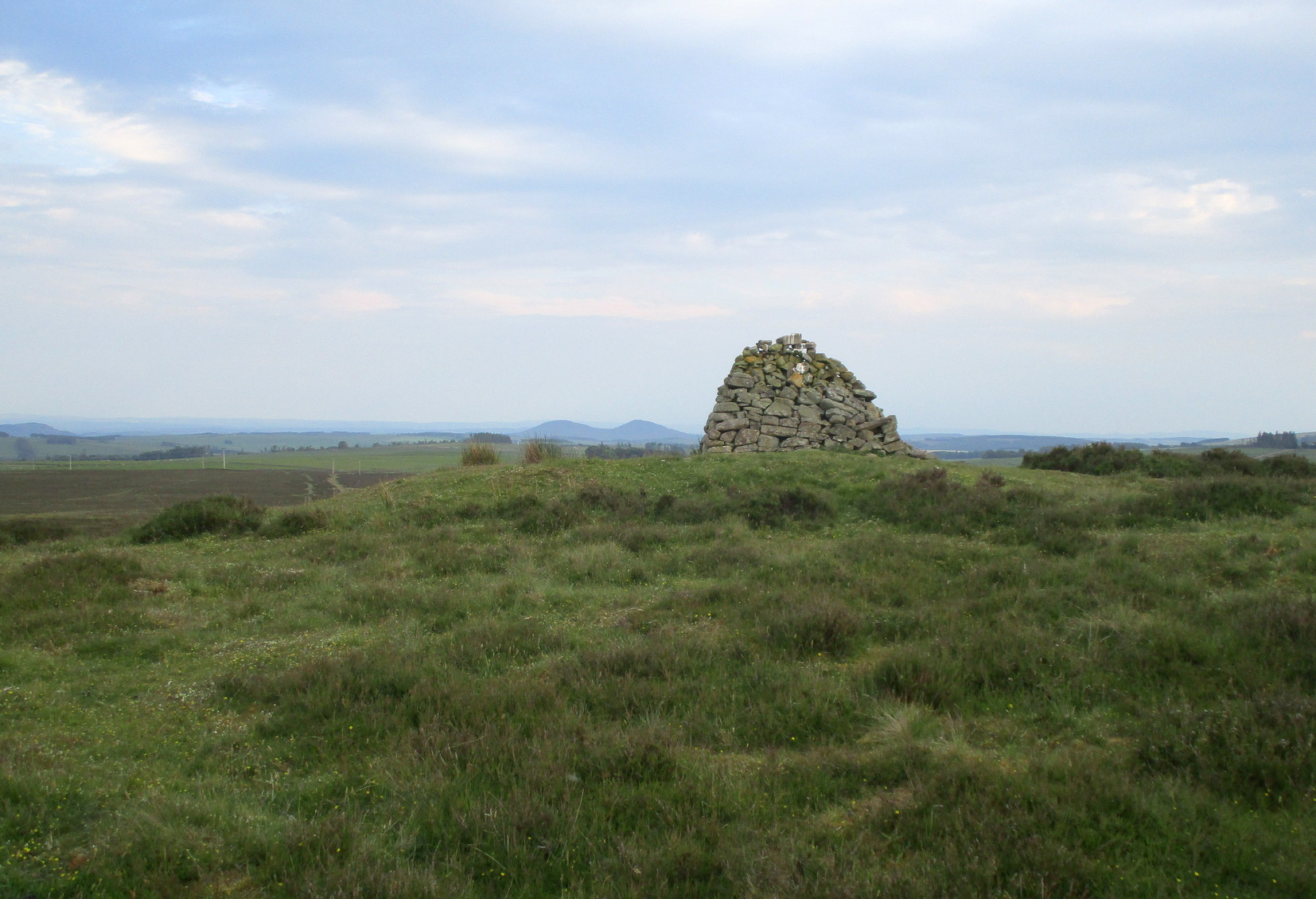
Looking to the southeast
The first thing that you see as you approach here is a modern cairn which is sat upon the more ancient and completely overgrown one. You can’t really see the “ancient” section of it until you walk round to its more northern side, where you’ll then notice how the new cairn has been built on top of a small but artificial rise in the ground, about ten yards across. This is the original ancient cairn. Sections of the ground have come away on its southern side, revealing a scattered mass of loose stones. It doesn’t seem to have been excavated but has all the hallmarks of being typically Bronze Age by the look of it. Of particular note is the superb view from here, not least towards the legendary Fairyland of the Eildon Hills, standing out clearly about 10 miles to the south…
Take the B6362 high road between Lauder and Stow and, regardless of which direction you’re coming from, when you reach the top heights of the moorland road with views all around, you need to keep your eyes peeled for where a dirt-track runs south and, diagonally across the road on its north side, is a dirt-track-cum-parking-spot. Park up here and walk 10 yards or so into the heather on your left. You’re probably stood at the side of it!
Archaeology & History
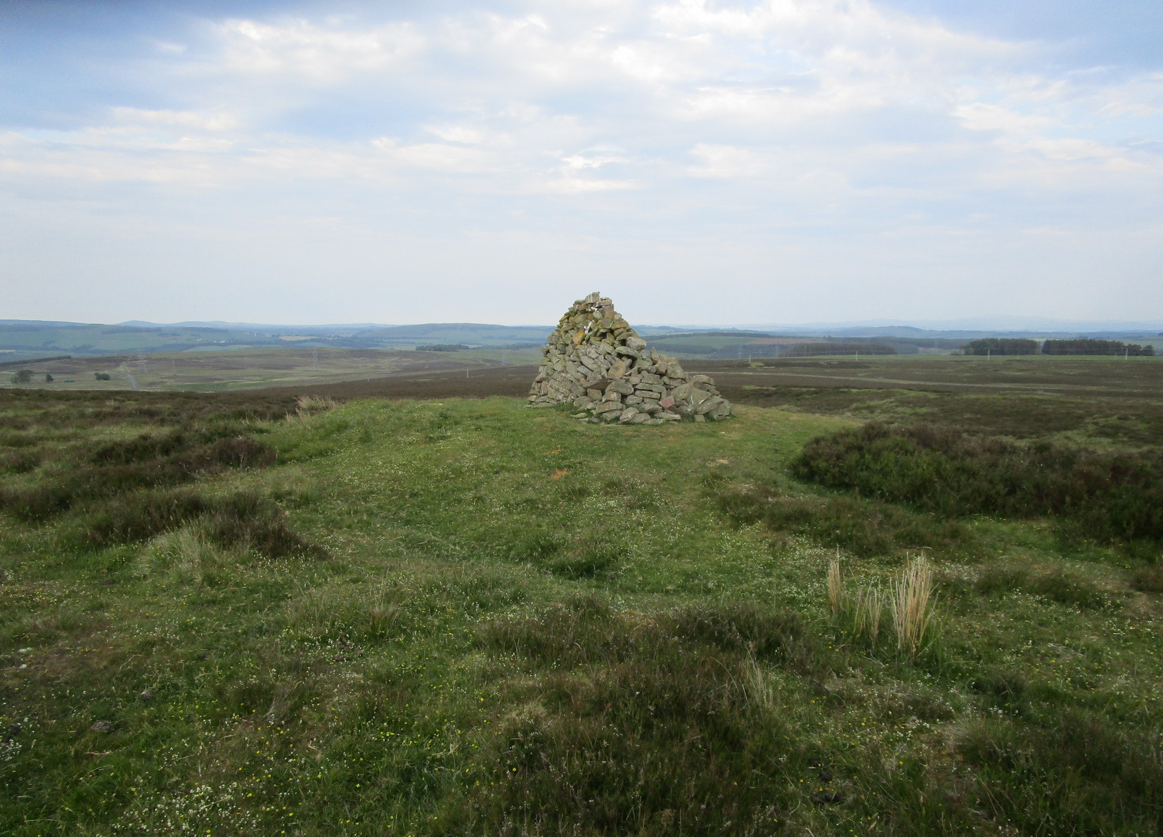
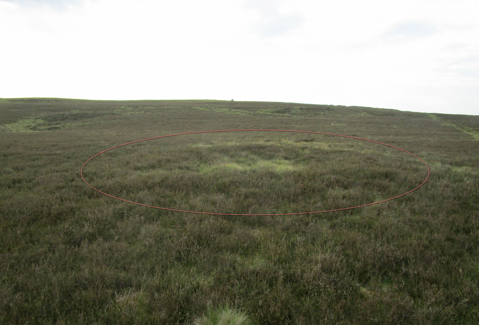
Hut circle (ringed) looking N
A very distinct, but isolated hut circle can be seen here when the heather is short. It’s most notable by seeing the slightly elevated circular rise in the ground with the rough ring of long grasses in the middle of it. To be honest, unless you’re a mad archaeo-geek into these sort of things, it’s not gonna send a rush of blood to your head.
Probably constructed in the Bronze Age, it’s a plain little thing about six yards across, making it suitable for perhaps just a couple of folk to have lived in. The overgrown walling is very low (between 12-18 inches high) and about a yard wide all the way round it. The main thing that you’ll get from this place is not only the sense of isolation, but the beautiful view…
Follow the same directions to reach the Allt Leathan enclosure and hut circles. Walk along the eastern side of the hill on which the enclosure mainly sits, and as it slopes down the hill, you’ll note an odd-shaped stone leaning at an angle less than halfway down.
Archaeology & History
A truly curious and fascinating site, not previously recorded, but found by Paul Hornby on August 7, 2012, during a venture to explore the nearby settlement and hut circles around Meall Dubh. On the eastern slope over the edge of the Allt Leathan enclosure, with its hut circles and possible cairns, we see this upright worn stone, leaning at an angle, which would stand nearly 5 feet high if pushed properly upright. It is found in association with two other smaller stones, all of which stand and lean in the same direction.
Possible cairn remnants surrounds base of stone…and again
Around the base of the main stone is a scatter of small rocks, as if suggesting that a cairn was once next to the standing stone, perhaps inferring that the stone marked a tomb. There is also a very distinct line of walling running along the axis of the upright stones, meaning that we cannot discount the possibility that the monoliths here were connected with a walled enclosure in some capacity. And considering the excess of other prehistoric remains close by, this may be more likely than not!
Although found within the parish of Fortingall many miles to the south, this site is much closer to Kinloch Rannoch, just a few miles northwest. From Kinloch Rannoch, take the south road, heading east for about 5 miles, till you go past the small Lochan an Daim on the left (north) of the road. As the moorland opens up ahead of you, about a half-mile further on, watch for the dirt-track running up onto the hills on your left. Cross the road from here, over the stream and bogs, onto the small hill ahead of you. You’re getting very close!
Archaeology & History
The Canmore entry for this site tells of just a large single hut circle being here, 13.5m by 12m across, but this is in fact part of a much larger enclosure system with extensive walls rising to heights of up to 3 feet in places and covering a very wide area indeed across the sloping grass-covered ridge above the streams on either side. The walling is typically Iron Age in structure and there are remains of other internal features that we gave only cursory attention to (other sites were calling out for us!).
This shows walling of another nearby enclosureAllt Leathan enclosure walling
What seem to be a cluster of several very overgrown cairns, roughly 20 feet across and 3 feet high, are evident on the south side of the enclosure walling. These need examining in greater detail. Also, on the eastern slope below the edge of the main walled enclosure, Paul Hornby found what seems to be a prehistoric standing stone, leaning to one side, which if completely upright would be about 5 feet tall. There are also the remains of at least two other large walled enclosures further onto the hillside, just before you start walking up the slopes to Schiehallion. They appear to be similar in nature and structure to this one at Allt Leathen, but I can find no account of them in any records.
If you follow the directions to reach the Churn Milk Joan stone, then continue onto the moor following the same directions to find the Miller’s Grave, once you’ve reach this you’ll see a large rounded boulder a couple of hundred yards away on your left, to the northwest. That’s Robin Hood’s Penny Stone!
Archaeology & History
Robin Hood’s Pennystone, Midgley Moor
In terms of this site’s archaeology, it has none to write home about in official records (other than a few flints found nearby), but there’s more to this place than meets the eye. A large rounded boulder sat upon the moorland plain with a large Nature-worn bowl on its top, the site is some 112 yards (102m) northwest of the little-known, but impressive Miller’s Grave prehistoric cairn (close to being a midsummer/midwinter line). North and south of the rock are small lines of prehistoric walling — though their context is difficult to assess. The Greenwood Stone and Greenwood B stone can be found about 200 yards west.
Folklore
A singular footpath once led up to this old boulder, atop of which – in its large ‘bowl’ – vinegar used to be poured. In this, coins were left by local people who suffered the plague and in return food was left for them. And of course it is said that Robin Hood frequented the place in bygone times.
References:
Bennett, Paul, The Old Stones of Elmet, Capall Bann: Milverton 2001.
Robert, Andy, “Our Last Meeting,” in NEM 37, 1989.
Robert, Andy, Ghosts and Legends of Yorkshire, Jarrold: Sheffield 1992.
From the village of Midgley, high above the A646 Halifax-to-Todmorden road, travel west along the moorland road until you reach the sharp-ish bend in the road, with steep wooded waterfall to your left and the track up to the disused quarry of Foster Clough. Go up the Foster Clough track for 100 yards and, when you reach the gate in front of you, go over it but follow the line of the straight walling uphill by the stream-side (instead of following the path up the quarries) all the way to the top. Here you’ll see the boundary stone of Churn Milk Joan.
Archaeology & History
The present large standing stone you see before you isn’t prehistoric. However, the small broken piece on the ground by its side may have been its prehistoric predecessor; and there is certainly something of an archaic nature here — albeit a contentious one — as we find old cup-markings cut into its eastern face.
Two ‘cup-marks’ on eastern face
The upright is roughly squared and faces the cardinal points. It was described in Mr Heginbottom’s (1977) unpublished survey on Calderdale rock art, where he described there being a few cup-markings inscribed on its east- and south-facing edges, some of which may be prehistoric — though they would obviously have had to have been carved upon the upright stone when it still lay earth-fast. However, we must posit the the notion (unless some of you have better ideas) that the tradition of etching cup-marks onto rocks was still occurring in this part of Yorkshire until the late Middle Ages, as this stone was, as we know from boundary records, only placed upright to mark the meeting of the three boundaries of Wadsworth, Hebden Royd and Sowerby.
Churn Milk Joan’s other name, Saville’s Low, originates from the great Saville family who owned great tracts of land across the region in the fourteenth century, possibly when the Churn Milk Joan we see today was created. The word “lowe” may derive from the old word meaning, “moot or gathering place,” which this great stone probably served as due to its siting at the junction of the three townships.*
Folklore
In modern times the stone has become a focus for a number of local pagans and New Agers who visit and ‘use’ the site in their respective ways at certain times of the day, albeit estranged (ego-bound) from the original mythic nature of the site.
The name of the stone comes from an old legend about a milk-maid named Joan who, whilst carrying milk across the moors between Luddenden and Pecket Well, got caught in a blizzard and froze to death. When her body was found many days later, the stone we see here today was erected to commemorate the spot where she died. Although such a scenario is quite likely on these hills, as Andy Roberts (1992) said,
“Considering the sheer amount of sites with similar legends this explanation is unlikely to be true and we should looker deeper for the meaning behind Churn Milk Joan, to be found in its positioning in the landscape and ourindividual feelings about it.” [see profiles for the Two Lads and the Lad o’ Crow Hill sites)
The monolith’s other title, Churnmilk Peg, is the name given to an old hag who is said to be the guardian of nut thickets. How this female sprite came to find her abode upon these high hills is somewhat of an enigma, but it was first stated as such in an article by Andy Roberts (1989) in “Northern Earth Mysteries” magazine. E.M. Wright (1913) noted this supernatural creature in her work on folk dialect, describing it as a West Yorkshire elemental who, along with another one known as Melsh Dick:
“are wood-demons supposed to protect soft, unripe nuts from being gathered by naughty children, the former being wont to beguile her leisure by smoking a pipe.”
Another legend of the stone tells how it is said to spin round three times on New Year’s Eve when it hears the sound of the midnight bells at St. Michael’s church (St. Michael was a dragon-slayer) at Mytholmroyd in the valley below. Another piece of folklore tells that coins used to be left in a small hollow at the very top of the stone which, according to Haslem (1981), was “a gift to the spirit world, to bring luck” – a common folk motif. It may equally originate from the custom of it as a plague stone. This tradition of leaving coins atop of the stone is still perpetuated by some local folk.
Mr Haslem also made some interesting remarks about the nature of Churn Milk Joan standing as a boundary stone, representing something which stands not just as a physical boundary, but as a boundary point between this and the Other- or spirit world. In folklore, streams and rivers commonly carry this theme. But here on Midgley Moor, as a standing stone at the junction of three boundaries, we may be looking at the place as an omphalos: a centre point from which the manifold worlds unfold. (see Almscliffe Crags, the Ashlar Chair and the Hitching Stone)
The other motif here, of milk and snow [both white], have been speculated to represent power of the sun at midwinter, and geomantically we find the position of the stone in the landscape exemplifying this: it stands midway in the moorland scenery facing south, the direction of solar power, yet is bounded as an equinox marker from east and west. The winter tales it has nestled around it are merely complementary occult augurs of its more wholesome elements at this point in the hills.
There is however, another much more potent element that has not been conveyed about the site and its folklore—and one which has more authenticity and primary animistic quality. Regardless of ‘Joan’ or ‘Peg’ being the elemental preserved in the landscape title, the ‘churning’ in its name and the ‘spinning’ of the stone in myth at the end of one year and the start of the next at New Year, are folk memories of traditional creation myths that speak of the cyclical seasons endlessly perpetuated year after year after year, in what Mircea Eliade (1954) called the ‘myth of the eternal return.’ As season follows season in the folk myths of our ancestors, everything related to the natural world: a world inhabited (as it still is) by feelings and intuitions learned from an endless daily encounter, outdoors, with the streams, hills, gales, snow and fires. Their entire cosmology, as with aboriginal people the world over, saw the cycles of the year as integral parts of their daily lives. Here, at Churn Milk Joan with its central landscape position along an ancient boundary, the churning and turning of the year was commemorated and mythologized year after year after year; with maybe even the Milky Way being part of the ‘milk’ in its title, from which, in the shamanistic worlds that were integral to earlier society, the gods themselves emerged and came down to Earth.
References:
Bennett, Paul, The Old Stones of Elmet, Capall Bann: Milverton 2001.
Eliade, Mircea, The Myth of the Eternal Return, Bollingen 1954.
Haslem, Michael, “Churn Milk Joan: A Boundary Stone on Midgley Moor,” in Wood and Water, 1:8, 1980.
Heginbottom, J.A., “The Prehistoric Rock Art of Upper Calderdale and the Surrounding Area,” Yorkshire Archaeology Society 1977.
Ogden, J.H., “A Moorland Township: Wadsworth in Ancient Times,” Proceedings of the Halifax Antiquarian Society, 1904.
Robert, Andy, “Our Last Meeting,” in NEM 37, 1989.
Robert, Andy, Ghosts and Legends of Yorkshire, Jarrold: Sheffield 1992.
Wright, Elizabeth Mary, Rustic Speech and Folk-Lore, Oxford University Press 1913.
* The great stone at the cente of the Great Skirtful of Stones, Burley Moor, which previously stood at the centre of the Grubstones Circle, was just such a moot stone. Upon it is carved the words “This is Rumble’s Lawe”.