Legendary Stone (destroyed): OS Grid Reference – NT 1292 7840
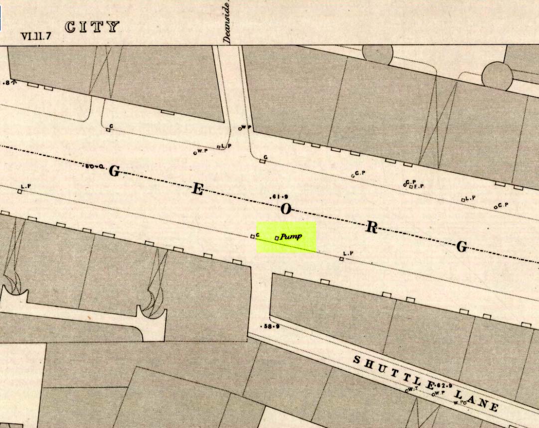
Bell Stane on 1896 map
Archaeology & History
An intriguing site that needs adding to the Northern Antiquarian due to the foraging research of the Edinburgh historian Stuart Harris (1996). Although the Bell Stane has been ascribed by the Canmore researchers to be just,
“a stone near the Mercat Cross on which the hand bell was set (rung to herald the opening of the weekly market or annual fair),”
Mr Harris dug deeper and found other references which led him to think that the site was “a conspicuous boulder or standing stone.” I have to agree with him. In his outstanding work on the historical place-names of Edinburgh and district, Harris wrote:
“The Bellstane…is noted on Ordnance Survey 1854 as the name of an object just outwith the burgh boundary and in the southwest corner of the little square that now bears the name. Whilst it has been surmised that it was a stone named for a handbell rung beside it on market days, in point of fact a burgh council meeting of 1642 (quoted in Morison’s Queensferry, p.131) records that a piece of ground hitherto waste and unused, within the burgh but near the bellstane, was to be set aside for markets and fairs in times coming; and the clear inference is that the name belonged to the stone before any markets were held near it. In absence of a reliable description of the stone or of early forms of its name, the origin of the name can only be guessed at. Similar names (of sites) in Kirknewton and Whitburn are no better documented, but the early forms of Belstane in Lanarkshire (Bellitstane, Bellistane, Belstane and Bellstane prior to 1329 and Beldstanein 1452) suggest that its first part may be Anglian ballede or early Scots bellit (from a Celtic root, ball, white), making the name ‘the stone with a white or pale patch or stripe on it’ — such as one with a band of quartz running through it. A conspicuous boulder or standing stone of this sort on this spur of higher ground above the shore would have been a useful meith or landing mark for boats making for the narrow landing place at the Binks.”
If anyone uncovers additional evidence about this Bell Stane that can affirm it as a standing stone (or otherwise), we will amend its status.
References:
- Harris, Stuart, The Place-Names of Edinburgh: Their Origins and History, Gordon Wright: Edinburgh 1996.
- Morison, Alexander, Historical Notes on the Ancient and Royal Burgh of Queensferry, West Lothian Courier: Bathgate 1927.
- Orrock, Thomas, Fortha’s Lyrics and other Poems, privately printed: Edinburgh 1880.
© Paul Bennett, The Northern Antiquarian 2016