Described in the Field Lore of Timble village by William Grainge (1895) are the names and short histories of some of the local place-names—with this in particular standing out like a veritable sore thumb! Quite plainly, as Grainge told us,
“The name ‘Longbarrows’ is indicative of some burial mounds of a very early day. None exist at present. The land is under the plough, and is about the best in the township.”
But I cannot locate the position of this long-lost site and it’s not shown on any of the early OS-maps hereby. Grainge said that the land on which it once stood was owned by a local farmer called Charles Dickinson, who leased it out to others. He wrote:
“Dickinson had in Longbarrows 3 roods* and 23 perches*, and William Jackson’s share in Longbarrows was 1 acre, 3 roods and 21 perches. Besides these, John Ward of Nether Timble had 1 rood and 17 perches int he same field, a long narrow slip without fence, between Dickinson’s and Jackson’s lots.”
Does anyone know where this was? One of my suspects is the gathering place of the Fewston witches, a half-mile south of the village; but no remains of anything can be found there today and I may just be barking up the wrong tree.
The area south and west of here is rich in little-known prehistoric heritage, from the cairn-fields of Askwith Moor, the cairn circle at Snowden Crags, the settlements of Snowden Carr and the extensive petroglyphs all over the place! Giants cairns of the early Bronze Age and neolithic period were also once more numerous upon the moors to the west and south, so the former existence of a long barrow in Timble wouldn’t necessarily be too unusual. But where was it?!
References:
Grainge, William, The History and Topography of the Townships of Little Timble, Great Timble and the Hamlet of Snowden, William Walker: Otley 1895.
* A rood is an English unit of area, equal to a quarter of an acre or 10,890 square feet; a perch was a more variable unit of measure, being lengths of 161⁄2, 18, 21, 24 and 25 square feet.
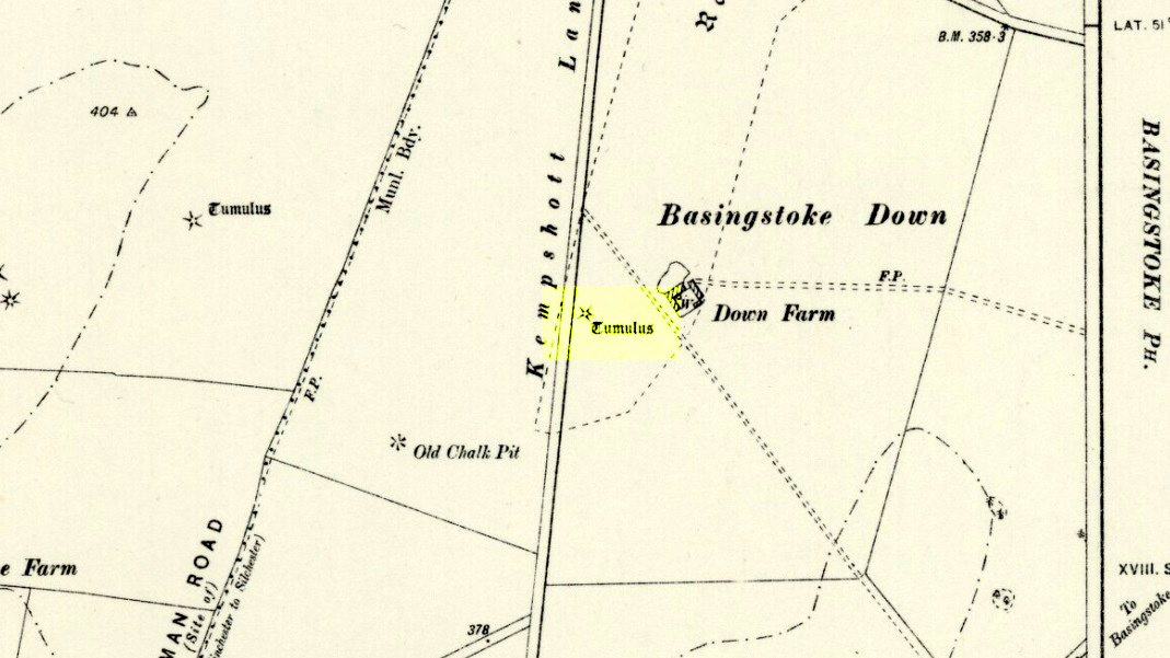
Barrow (destroyed): OS Grid Reference – SU 6018 5013
Archaeology & History
Downs Farm tumulus on 1897 map
On the western edges of Basingstoke, at Kempshott, could once be found this ancient site—destroyed many decades ago. It was one of number of similar prehistoric burial mounds in the area. First described in a listing of tumuli by Mr Andrews (1898) who told us that it was “oval” in shape, the monument was completely destroyed in 1939 and according to the Royal Commission (1979) lads,
“its site now lies beneath a house at the southwest corner of Kempshott Lane and Homesteads Lane.”
When the house where it once stood was being constructed, a collared urn was recovered from the tomb, which the Royal Commission thought indicated “that the monument (was) likely to have been of early Bronze Age date”—but obviously we cannot be sure. The site was listed in Leslie Grinsell’s (1979) extensive survey of prehistoric tombs in the area, in which he suggested it may have been a long barrow.
References:
Andrews, S., “A Short List of Some Tumuli in North Hampshire,” in Proceedings of the Hampshire Field Club & Archaeological Society, volume 4, 1898.
Grinsell, Leslie V., “Hampshire Barrows – part 3,” in Proceedings of the Hampshire Field Club & Archaeological Society, volume 14, 1940.
Royal Commission on Historic Monuments, England, Long Barrows in Hampshire and the Isle of Wight, HMSO: London 1979.
Willis, G.W., “Bronze Age Burials round Basingstoke,” in Proceedings of the Hampshire Field Club & Archaeological Society, volume 18, 1953.
Long Barrow (destroyed): OS Grid Reference – TL 086 268
Archaeology & History
Aligned east-west, a large neolithic long barrow could once be seen to the west of Galley Hill, on where now we find a golf course. It was sadly destroyed sometime around 1900 AD and its demolition was witnessed by a Mr A. Cumberland of the Dartford Antiquarian Society, who reported there being no archaeological finds of note in the tomb. Curious…
Equally curious was the view of archaeologist James Dyer (1964) in his assessment of the site, who wrote how
“Air photographs suggest that the barrow was 300 ft long, but this is much larger than normal in the Chilterns, and 150 ft is more reasonable.”
The neolithic and Bronze Age burial specialist Paul Ashbee (1984) maintained the “300 feet” measurement.
Other tumuli can still be seen on the slopes either side of Galley Hill a few hundred yards to the east; and a henge monument has also be found in the area.
References:
Ashbee, Paul, The Earthen Long Barrow in Britain, Geo: Norwich 1984.
Dyer, J.F., “A Secondary Neolithic Camp at Waulud’s Bank, Leagrave,” in Bedfordshire Archaeological Journal 2, 1964.
This was one site amongst a good cluster of prehistoric burials in this area, although most of this particular tomb has been destroyed. It was first located and described as a result of aerial surveying in the 1940s and described soon after the war in a short article by Mr G.C. Dunning (1946), who told us:
“An unrecorded long barrow is situated at South Wonston, immediately north of Worthy Down, in the parish of Wonston, 4 miles due north of Winchester (6-in OS Hampshire sheet 33 SW), Lat. 51° 7′ 15″ N, Long. 1° 19′ 30” W. The site was first noticed from the air in 1944 and has been visited several times. The barrow is enclosed in a loop of the 350ft contour, and the subsoil is chalk.
Map of siteAerial view of site
“The axis of the barrow is north-east to south-west; at about one-third from the west end it is crossed by a road. West of the road about 90ft of the mound is preserved in good condition and grass-grown; it is 60ft wide and 5ft high. On the south side the flanking ditch can be traced; a hedge runs along the north side and the ditch is obscured by a garden. A flint end-scraper, 3in long, with thick white patination, was picked out of the section of the mound on the west side of the road. East of the road the mound extends into a cultivated field and it has been much reduced by constant ploughing; it is now about 1ft high and the soil contains more chalk than elsewhere in the field. The ditches are parallel and show up as dark lines on the air-photograph (see b&w image), taken in April 1946. The ditches are continued round the east end of the barrow, an unusual feature proved in the long barrow at Holdenhurst, near Christchurch, Hants… No indications of structures or burial-pits can be detected within the east end of the mound, which is therefore of the unchambered type and built of chalk rubble… The total length of the barrow is about 340ft; it is thus probably the longest barrow in Hampshire.”
Mr Dunning goes onto mention the existence of another round barrow in the same field, a little to the east, “about 80ft in diameter and 3ft high.” Since his day, several other monuments have been found in the locale.
References:
Dunning, G.C., “A New Long Barrow in Hampshire,” in Antiquaries Journal, volume 26, 1946.
Royal Commission on Historical Monuments, England, Long Barrows in Hampshire and the Isle of Wight, HMSO: London 1979.
Pretty easy really. From Shipton-under-Wychwood take the A361 road north (to Chipping Norton) for just over 2 miles. You’ll pass the TV mast on your right and then a small country lane sign-posted to Ascott-under-Wychwood. Go past this and then stop at the next right-turn a half-mile further up the road. The barrow is about 100 yards before this turning, in the hedgerow, on the left-hand side of the road!
Archaeology & History
This once great and proud neolithic monument is today but a shadow of its former self. Described by various antiquarians and archaeologists over the years, O.G.S. Crawford (1925) included it in his fine survey, telling:
“The barrow is between 160 and 170 feet long and stands in two fields on the west side of the Chipping Norton and Burford main road… In the northern field, at the NE end of the barrow, stands a single upright stone, 6 feet high, 5 feet broad and 1 foot 6 inches thick. This stone is stated to be buried three feet deep in the ground and its height is given by Conder as 10 feet 6 inches. When visited October 18, 1922, a large piece of the top had been broken off, but replaced in position.”
This damage was reported around the same time and described in the early “Notes” of The Antiquaries Journal by a Mr A.D. Passmore (1925), who wrote:
“About 30ft from the north-east end of this long barrow stands a large monolith now nearly 6ft above ground…and roughly 6ft wide and just under 2ft thick, of local stone. At the top is an ancient and natural fissure extending right across the stone and penetrating some way downwards obliquely. Early in 1923, either by foul play or natural decay, another crack appeared spreading towards the first about a right-angle, the result being that a large piece at the top of the monolith became detached. Such an opportunity of mischief was speedily taken advantage of and the piece of stone, weighing over 4 cwt, was pushed off and fell to the ground. In August 1924 the owner of the land, his man, and the writer spread a bed of cement and hoisted up the large broken mass and relaid it in its bed.”
But even in their day, the tomb had already been opened up and checked out, by a Lord Moreton and a Mr Edward Conder, in 1894 no less! Conder’s account (1895) of the inside of this ancient tomb told:
“There were found (1) a chamber at right angles to the long axis of the barrow; on the south-eastern side of the barrow were two uprights, 4 feet 2 inches by 2 feet 1o inches, and 1 foot 9 inches by 2 feet 8 inches. At the north-western end of the chamber were two uprights set with their long faces (edges?) abutting. On the surface-line at the level of the base of the barrow were traces of paving and fragments of bone, pottery and charcoal. (2) Chamber, a little south of the south-east corner of No.1, slightly above the ground level. It was formed of three uprights, on the north, east and west sides respectively, and a paving slab with a perforation 4 inches in diameter. At the north-eastern end of the barrow was a ridge of large ‘rug’ stones up to 8 feet long, 5 feet wide, and 2½ feet thick, terminating in a standing stone…10 feet 6 inches high…buried 3 feet below ground level. At the southwest end was a standing stone, 4½ feet by 3 feet by 11 inches thick, in a horizontal position lying east and west, 2 feet below the surface. At various points were found skulls and human and animal bones and hearths, with no indications of date, and (as secondary interments) two Saxon graves.”
Today, poor old Lyneham Barrow is much overgrown and could do with a bittova face-lift to bring it back to life. But I wouldn’t hold y’ breath…..
Folklore
At the crossroads just above this old tomb, the ghost of a white lady is said to roam. And at the old quarry on the other side of the road a decidedly shamanistic tale speaks of an old lady who lived in a cave and guarded great treasure! Her spirit is sometimes seen wandering about in and around the fields hereby.
References:
Bennett, Paul & Wilson, Tom, The Old Stones of Rollright and District, Cockley: London 1999.
Brooks, J.A., Ghosts and Witches of the Cotswolds, Jarrold: Norwich 1992.
Conder, Edward, “An Account of the Exploration of Lyneham Barrow, Oxon,” in Proceedings of the Society of Antiquaries, volume 15, 1895.
Crawford, O.G.S., Long Barrows of the Cotswolds, John Bellows: Oxford 1925.
Dyer, James, Discovering Regional Archaeology: The Cotswolds and the Upper Thames, Shire: Tring 1970.
L.V. Grinsell’s Ancient Burial Mounds of England, Methuen: London 1936.
James, Dave, “A Brief Foray into Oxfordshire,” in Gloucestershire Earth Mysteries 14, 1992.
Passmore, A.D., “Lyneham Barrow, Oxfordshire,” in Antiquaries Journal, 5:2, April 1925.
Turner, Mark, Folklore and mysteries of the Cotswolds, Hale: London 1993.
Long Barrow (destroyed): OS Grid Reference – SS 5848 9227
Also Known as:
Cae Bryn-y-garn
Archaeology & History
Described in 1925 in a report by the Royal Institute of South Wales as “the remains of a long barrow,” it seems that all remains of this old site have been destroyed. Where the long tomb once stood are now some bungalows (anyone know if they’re haunted!?).
The tomb was quite an impressive one from all accounts: aligning north-northeast, it was some 20 yards long and 10 yards wide (at its widest), standing between 6-8 feet tall. When building operations started here in 1959, a disturbed mound of stones was noticed, but by 1965 the bungalows had been built where once rested the ancient dead.
The field-name to its immediate east — Cae Bryn-y-garn — tells us the old name of the cairn, as known to local folk. Quite what its folklore may have been, I’ve yet to hear…
References:
Royal Commission on the Ancient & Historical Monuments, Wales, An Inventory of the Ancient Monuments in Glamorgan – Volume 1, HMSO: Cardiff 1976.
Long Barrow (destroyed): OS Grid Reference – SO 169 357
Also Known as:
Croesllechau
Archaeology & History
It appears to have been Theophilus Jones who first mentioned this all-but-lost megalithic tomb, more than 200 years ago. He told that,
“In a field called Croeslechau about two miles eastward of (Talgarth), but in the parish of Bronllys and on a farm called Bryn-y-groes, is a cromlech, not merely interesting on account of its antiquity, but from the circumstance of a white thorn growing close, and indeed under part of it, which has gradually raised the horizontal or covering-stone several inches out of its original position; it is therefore not only venerable as a relic of very ancient days, but as a natural curiosity.”
Croesllechau tomb in 1809
Thankfully he gave us the fine old drawing of the tomb, here reproduced.
Although shown on an 1832 map of the region, when Crawford (1925) came to describe this old tomb it had already been destroyed. He told that,
“the site is unknown and all memory of it is has completely vanished in the neighbourhood. Mr Evan Morgan had visited the site and reports that no traces of the ‘cromlech’ were visible; nor were enquiries of the farmer at Bradwys any more successful in identifying the site. It is not unlikely that the monument was destroyed when a new road was made…”
References:
Crawford, O.G.S., The Long Barrows of the Cotswolds, John Bellows: Gloucester 1925.
Jones, Theophilus, History of the County of Brecknock, volume 2, George North: London 1809.
Easy enough this one. Take the B4066 west of Woodchester past the Boundary Court and over the cattle grid for 100 yards or so. Note the fence up the slope to your left (south) up the field here head for the triangulation pillar. Once there keep walking for about another 100 yards. You can’t miss it!
Archaeology & History
The mad craniologist John Thurnam (1810-73) was one of several old-school fellas who helped to excavate this grand site on one occasion. Thinking that human sacrifice lay behind virtually all of the burial mounds, Thurnam was part of the Cotteswold Field Club group who investigated the place; and, because of his intellectual capacity in cranial investigations, was listened to by the budding archaeo’s of the day cos he was cleverer than them (hero worshipping). A bit naive of them, but such is the way of some folk! Yet their early account of this site (devoid of Thurnam’s weird notions) is quite invaluable, even today. Described in an address by their President in the Proceedings in 1865, the article tells:
“The Club met at Stroud. The principal work of the day was the opening of a ‘barrow’ on Bown Hill…which had formed the subject of discussion towards the end of the previous season when, the period of the year being too far advanced, the work of exploration was deferred. Workmen had been employed under Dr Paine and Dr Witchell on the two previous days; but beyond the discovery of the entrance to the sepulchral chambers no great progress had been made in the excavation of the mound which, from its size and solidity, proved to be a very laborious operation. In order, therefore, to expedite matters, a strong force of labourers, 22 in number, had been employed from an early hour on the day of the meeting. The mound, which measured about 60 yards in length by 17 in extreme width, was seen to be constructed of angular masses of stone, heaped together without any order or regularity, amongst which were scattered blocks of considerable size and weight.
“The excavators had opened a trench about 100 feet in length, in a direction due east and west by compass. The western extremity was the broadest, the mound gradually diminishing in width to the opposite end. The workmen had struck upon the entrance which, when exposed, showed a chamber formed of five large, unhewn stones, two on each side and one placed transversely, the dimensions of which were 4 feet in width by 8 feet 6 inches in length. There was no covering stone, but the entrance was flanked on either side by a wall of dry masonry, very neatly fitted, forming a segment of a circle, which, if completed, would have enclosed a well-like chamber in front of the entrance to the tumulus. This wall had been abruptly broken off; but there were amongst those present some who thought they detected signs of it having been at one time continuous. It was evident that the whole structure had been thoroughly ransacked and broken up by former explorers; and so completely had the work of devestation been accomplished that hardly one stone was left upon another. The chambers, with the one exception already noted, had been entirely demolished, and but a few bones scattered throughout the whole tumulus remained, all more or less in a fragmentary condition. These fragments comprised one fully developed frontal bone, male; portions of two male lower jaws, and portions of two female skulls; several thigh bones, and bones of the leg and foot, including the remains of children, but all much broken. There were found the remains of six indiiduals at the least, viz, two men, two women and two children, the latter between six and eight years of age. There were several bones of cattle and calves; teeth of horse and ox; a portion of the bones of the foreleg of a dog; several boar’s teeth, tusks and grinders, and parts of jaw bones; a bone ‘scoop’, formed of a shank bone of a horse; and a large quantity of a black unctuous substance, having the appearance of wood or animal charcoal; but no burnt bones. A small portion of a small flint flake was detected in the black paste. Besides the organic remains above enumerated, some pieces of rude pottery were found, which, with a Roman brass coin of the Emperor Germanicus, complete the list of objects yielded…”
Some of the remains found in Bown Hill’s long barrow
A few years later George Witts’ (1883) described the tomb but added little to the description above. When Crawford (1925) came here in December, 1920, the greatest height of the tomb was just ten feet and he described that “the extreme eastern end has been destroyed by quarrying.” He could clearly discern various trenches and the remains of previous excavations around the tomb, but added little further, apart from an important geomantic ingredient:
“It stands near the highest point (763 feet) of the hill and commands a magnificent view. South eastwards can be seen the Berkshire Downs (probably the White Horse Hill and Wayland’s Smithy); northwards May Hill and the Malvern Hills are visible; in the western distance are the Brecknock Beacons and the Black Mountains…”
Crawford later received further notes about the 1863 dig at Bown Hill from the son of Dr Paine that had been written following the original excavation. Although they convey little extra from the above account, I’ll add the notes to this entry in the near future.
References:
Crawford, O.G.S., The Long Barrows of the Cotswolds, John Bellows: Gloucester 1925.
Darvill, Timothy, Prehistoric Gloucestershire, Alan Sutton: Gloucester 1987.
Grinsell, L.V., The Ancient Burial Mounds of England, Methuen: London 1936.
Guide, W.V., ‘Address to the Cotteswold Naturalists’ Field Club,’ in Proceedings of the Cotteswold Naturalists’ Field Club, volume 3, 1865.
Witts, George, Archaeological Handbook of Gloucestershire, G. Norman: Cheltenham 1883.
Follow the same directions for getting to the Black Hill Round Cairn. It’s less than 100 yards away – you can’t miss it!
Archaeology & History
This is a superb archaeological site — and it’s bloody huge! It’s big and it’s long and it sticks out a bit – which is pretty unique in this part of the Pennines, as most other giant cairns tend to be of the large round variety. Although the site was originally defined by Arthur Raistrick (1931) as a long barrow, J.J. Keighley (1981) told how, “it was found to be a round cairn imposed on a long cairn.” And it’s an old one aswell…
Near the SE end of the giant cairnClose-up of the main cist
More than 220 feet long and 80 feet in diameter at its widest southeastern end, as we walk along the length of the cairn to its northwestern edge, its main body averages (only!) 45 feet in diameter. Made up of tens of thousands of rocks and reported by Butterfield (1939) to have had an upright stone along its major axis, the “height varies from 4-8ft, but the cairn has been much despoiled and disturbed,” said Cowling in 1946. He also told how,
“Excavation revealed that almost in the centre of the mound were the remains of a cist made of roughly dressed stone flags and dry walling, covered by a large stone. Under a stone slab, laid on the floor of the cist, were fragments of (burnt and unburnt) bone and a small flint chipping.”
This is a very impressive site and deserving of more modern analysis. The alignment of the tomb, SE-NW, was of obvious importance to the builders, believed to be late-neolithic in character. The tomb aligns to two large hills in the far distance in the Forest of Bowland which we were unable to identity for certain. If anyone knows their names, please let us know!
Folklore
The older folk of Bradley village below here, tell of the danger of disturbing this old tomb. In a tale well-known to folklorists, it was said that when the first people went up to open this tomb for the very first time, it was a lovely day. But despite being warned, as the archaeologists began their dig, a great storm of thunder, lightning and hailstones erupted from a previously peaceful sky and disturbed them that much that they took off and left the old tomb alone. (I must check this up in the archaeo-records to see if owt’s mentioned about it.)
References:
Ashbee, Paul, The Earthen Long Barrow in Britain, Geo Books: Norwick 1984.
Butterfield, A., ‘Structural Details of a Long Barrow on Black Hill, Bradley Moor,’ in YAJ 34, 1939.
Cowling, E.T., Rombald’s Way, William Walker: Otley 1946.
Keighley, J.J., ‘The Prehistoric Period,’ in Faull & Moorhouse’s West Yorkshire: An Archaeological Survey, I, WYMCC: Wakefield 1981.
Raistrick, Arthur, ‘Prehistoric Burials at Waddington and Bradley,’ in YAJ 30, 1931.