On the B837 between Balmaha and Drymen at the hamlet called Milton of Buchanan, at the little road junction where the houses are on the right, go uphill for 1 mile (1.6km) until you reach the West Highland Way, where you need to go left (NW). Keep walking for another half-mile (if you get to end of the forestry plantation, you’ve gone too far) where, on your left, a small widening valley appears. Walk along the eastern edge of this, keeping your eyes peeled for a small upright stone and two large flat companions next to it.
Archaeology & History
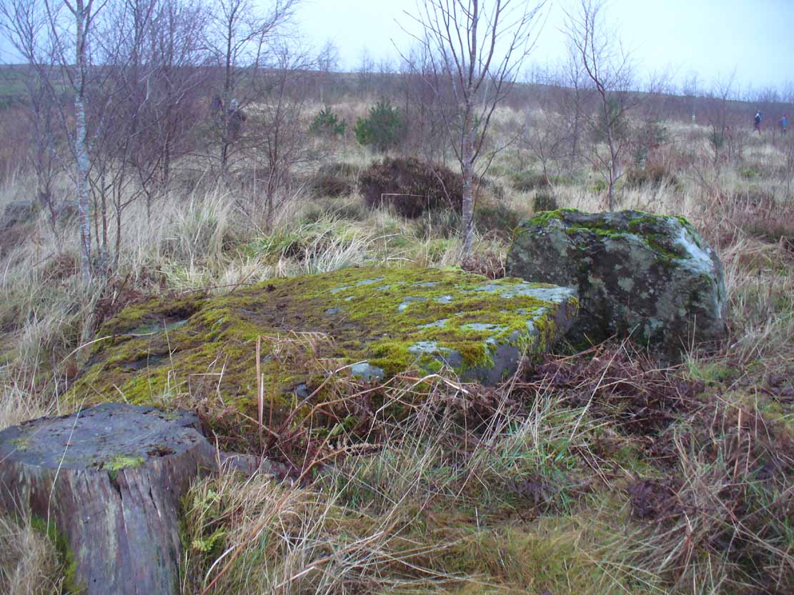
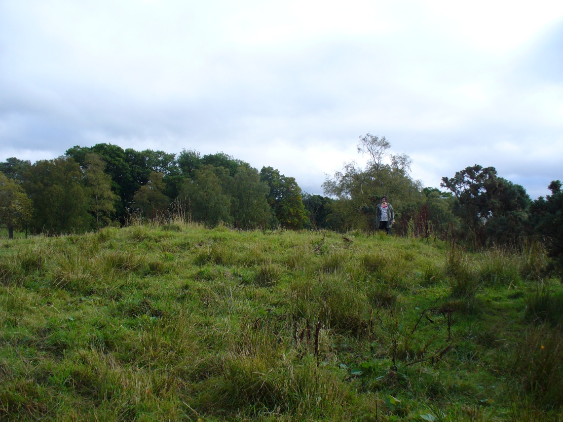
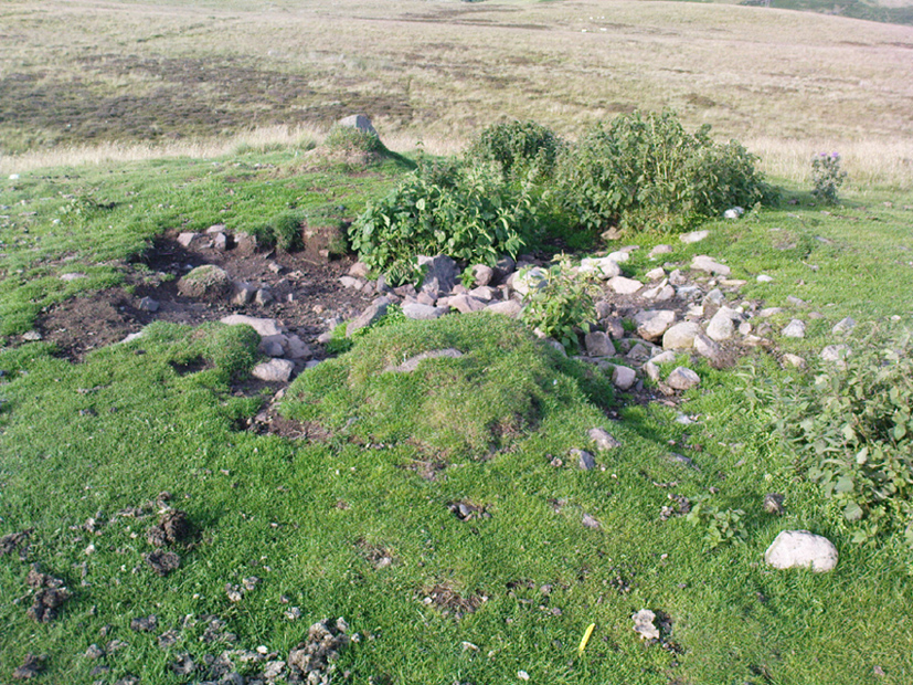
This site is really only for the archaeological purists amongst you, as the forestry plantation has truly taken its toll on the site and very little of it remains. It appears to have been described first of all in H.G. Smith’s (1896) masterful local history work—although popular tradition was not assigning the place as a prehistoric tomb of any sort. Rather, it possessed a somewhat familiar folklore element, well-known to occult historians and antiquarians. Smith told us:
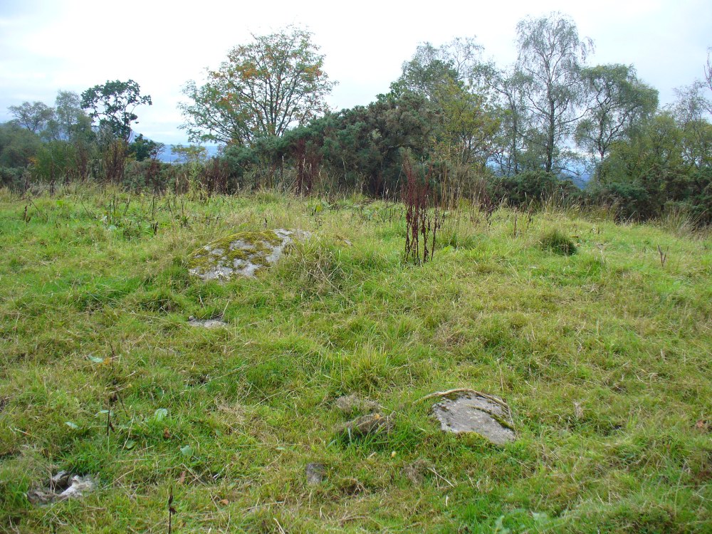
“Not far off, in Garradh-ban Wood, is the ‘Deil’s foot mark stone‘. It is a large flat stone, 7 feet long and 6 feet wide, with an impression on it not unlike a huge foot mark. There is another stone close to it, 7 feet by 5 feet. These stones were probably placed there for some purpose now unknown.”
Mr Smith’s dimensions of the stones correlate closely with the modern analysis taken up by the archaeologists who visited the site more than 100 years later. Mainly comprising of two large stones on the ground with an accompanying upright monolith on the western side, the official Canmore account tells us:
“The cairn has been reduced to a low stony mound measuring 15m from N to S by 12m transversely and up to 0.5m in height. The chamber, which lies off-centre to the SW, comprises two upright stones and two displaced capstones. The overall plan of the chamber can no longer be determined, and the two upright stones are set splayed to one another; that on the W measures 0.53m by 0.25m and 0.15m in height, and that on the E is heavily laminated measuring 1m by 0.18m and 0.8m in height. The SE corner of one capstone rests on the smaller of the two uprights. It measures 2.1m by 2.03m and up to 0.3m in thickness, and has two fragments broken off at its NE corner. The second capstone lies immediately adjacent to the N, flush with the surface of the cairn, and measures 2.3m by 1.7m and 0.17m in thickness.”
When they assessed the site in 2006, archaeologists reported finding small pieces of quartz scattered over the surface of the cairn, but when we visited here last week, there was little trace of any.
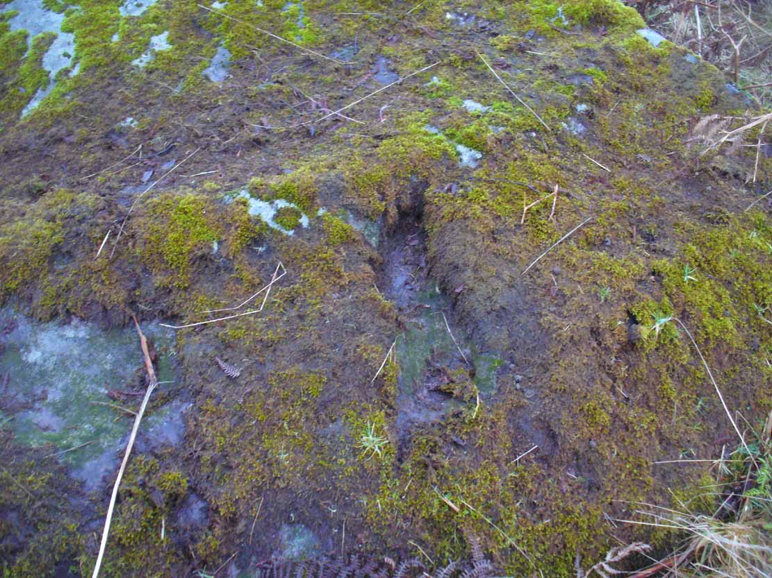
The ‘Deil’s foot mark’
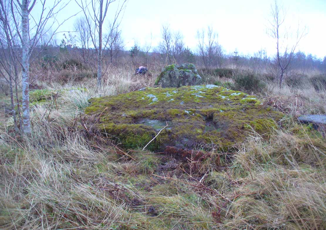
Garadh Ban, looking west
I was hoping that the “Devil’s footmark” on the stone was going to be a cup-marking of some form, as found at some other sites (Kilneuair church, etc)—but it wasn’t to be. Instead, it seems that the curvaceous indentation left by the ‘devil’ was simply a natural cavity. The folktale behind the name, and its possible cultural function, seems to have been forgotten.
Although (perhaps) unrelated, H.G. Smith told us of other remains not too far from here, which remain elusive and not in any official record-books. We had a quick meander over to see if there was anything to be seen, but daylight was fading fast and more searches are required. It sounds intriguing:
“A little above these ruins (of Cul-an-Endainn farmhouse at NS 4453 9244 – PB), on the right of the burn, but considerably above it, is a curious structure built of turf. It is quite round, and is 25 feet in diameter at the top and 15 feet at the bottom. It has entrances at the south, east and west. There are others of the same construction both above and below, but not so well defined.”
Recently, industrialists have gone onto this part of the countryside and have already began scarring the hillsides, perhaps even destroying these curious remains before we’ve had a chance to assess them. Hopefully however, they will remain untouched and allow us site analysis before any real damage is done.
Folklore
Followers of the christian cult said this site was a place where the devil had been.
Acknowledgements: Many thanks to Aisha Domleo, Lara & Leo Domleo, Unabel Gordon, Nina Harris, Paul Hornby and Naomi Ross for their help and attendance in finding this ancient site.
From Bridge of Allan go down the main A9 road towards the University, but turn left up the Sheriffmuir road, 100 yards up turning right to keep you on track up the steep narrow dark lane, turning left at the next split in the road. Follow this for a mile or two all the way to the very end where the tell-tale signs of the unwelcoming english incomers of ‘Private’ now adorns the Pendreich farm buildings. There’s a dirt-track veering uphill diagonally right from here. Go up here and as it bends slightly left, look into the open copse of trees to the highest point here less than 100 yards to you right. That’s it!
Archaeology & History
Lisa gives an idea of scale
The remains of this prehistoric tomb sits right on the very crown of the hill round the back of Pendreich, covered on its western edges by old gorse bushes. Its eye speaks with the nearby sites of the Fairy Knowe to the south, the fallen standing stone of Pendreich Muir to the northeast, the associated cairns to the east, and the Pictish fortress of Dumyat behind them. When I came up here for the first time last week with local archaeologist Lisa Samson, we found that the land upon which the cairn now lives is fertile with a variety of edible (Boletus, Amanita, etc) and sacred mushrooms (Panaeolina, Psilocybes, etc). And, despite being told by locals and the archaeology record as a place where very little can be seen, I have to beg to differ.
Fallen stone at the cairn edge
The crowning cairn is of course much overgrown and has been dug into in earlier years, but just beneath the grassy surface you can feel and see much of the stone that constitutes this buried site. The cairn itself rises a couple of feet beneath the grass and is clearly visible as you walk towards it. At its edges there seems to be the fallen remains of a surrounding ring of stones. Inside of this ring we can see and feel the overgrown rocky mass and open cists sleeping quietly, awaiting a more modern analysis to tell us of its ancient past. When the site was visited by the Royal Commission lads in the 1960s, they went on to tell us the following about the place:
“This cairn is situated on the summit of a low knoll within a felled wood, 170 yards ENE of Pendreich farmhouse at a height of 600ft OD. It consists of a low, grass-covered mound which measures 40ft in diameter and stands to a maximum height of 1ft 6in. The surface is disfigured by pits caused in 1926 when the cairn was opened and three cists were uncovered. Two of these contained no relics; in the third there were fragments of bones and a broken beaker, some sherds of which are preserved in the Smith Institute, Stirling.”
Although we find the scattered remains of old farm equipment lying round the edge of this tomb, it’s still a good site to visit and, I’d say, worthy of further archaeological attention.
References:
Royal Commission on the Ancient & Historical Monuments Scotland, Stirling – 2 volumes, HMSO: Edinburgh 1963.
Royal Commission on the Ancient & Historical Monuments of Scotland, Archaeological Sites and Monuments of Stirling District, Central Region, Society of Antiquaries of Scotland 1979.
Watson, Angus, The Ochils – Placenames, History, Tradition, Perth & Kinross District Libraries 1995.
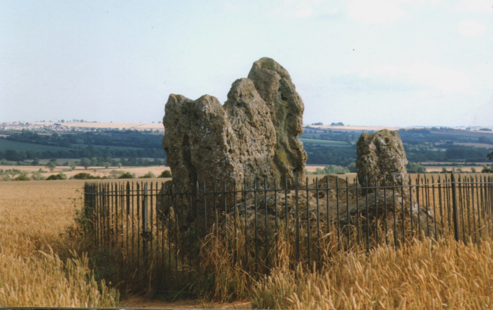
Follow the directions to reach the Rollrights stone circle, from Chipping Norton. Walk past the entrance to the circle along the road for a coupla hundred yards, keeping your eyes peeled looking into the field on your right. You’ll notice the large rocky mass of these Knights a hundred yards down in the field, which can be reached by a footpath running straight along the old hedge from the roadside straight to the collapsed tomb.
Archaeology & History
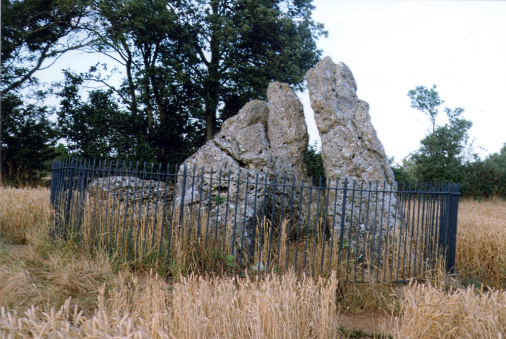
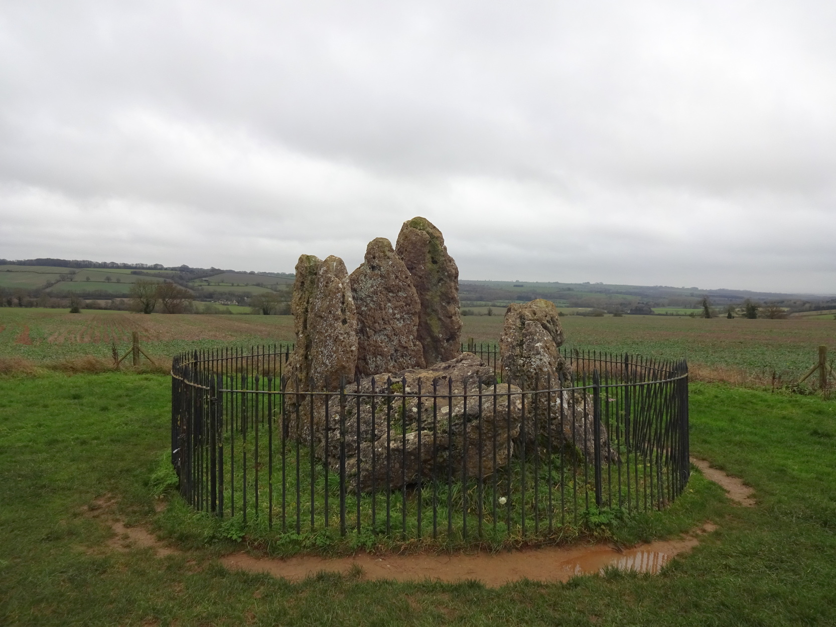
The Whispering Knights
A brilliant site—albeit nowhere like how it once was—where I slept a few times when I lived in the old hut at the Rollright stone circle down the road. A field-mouse lived here when I slept at the place and, hopefully, its ancestors still reside hereby (Rollright Trust’s poisons notwithstanding!). On my first encounter with the little fella, I felt him running into my waist-side whilst laying, dozing in the old tomb. He nudged into me—then again —and yet again; before I leaned over to see what was going on! And the little mouse looked up at me, without a care in the world, as if to say, “What are you doing lying on my path!? Can I get past please?” (though I’d not had a bath for a good 3 months, so didn’t smell like any modern human, which I think explained his total lack of fear)
Laying there, I smiled at the little fella, who then decided to jump up the side of my waist and walk over the top of me to get to the other side! He jumped down into the grasses and disappeared! However, a few minutes later, I felt another tiny ‘thud’ at my side and looked down to see the same lovely mouse wanting to go back along his obviously traditional route – and looking up at me again, whiskers twitching inquisitively, realised I was still here; and so once again took it upon himself to climb over the scruffy smelly human-sort who was blocking his route!
He was a gorgeous little mouse and we got to know each other quite well over the unwashed springs and summers I slept here….. But anyway, that’s not what you folks are interested in hearing about! Back to the archaeo-shit….
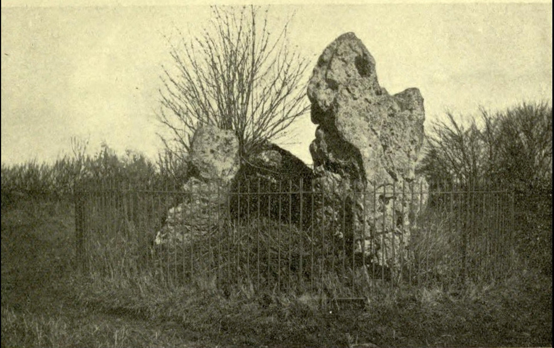
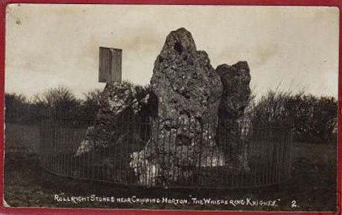
The Whispering Knights is one of the main sites in the cluster known collectively as the Rollright Stones, which also comprises of the standing stone commonly called the King Stone, plus the King’s Men stone circle a coupla hundred yards down the road from the Knights. They all sit atop of the ridge which separates the counties of Oxfordshire and Warwickshire along the edge of the prehistoric road known as the Jurassic Way. The sites are non-contemporaneous having been erected over a period of many centuries. The Whispering- or Five Knights are by far the oldest part of the complex dating from a period never previously anticipated. They comprise of four upright megaliths in close proximity, and a fifth fallen stone which is said to be the capstone on the original monument. This stone alone weighs some 10 tons.
The general archaeological opinion is that the place is a ‘portal dolmen burial chamber’ of which the capstone has fallen. The Oxford archaeologist George Lambrick (1988) postulated the stones to have been covered with a mound of earth, but any evidence supporting this has long since gone.
1920s postcard of the siteThe Knights in 1995
This great monument was initially thought by archaeologists to have been built sometime around 1800 BCE—a favourite date of academics for many an unexcavated site for many decades—until they turned their astute attention to the place in the 1980s. And what they found was astonishing. Well…astonishing for the archaeologists! Affirming the local folk tradition that the Knights were the “oldest monuments in Oxfordshire,” the dates truly went back. Way back! Datable remains at the site gave results from between 3500 and 3800 BCE: two thousand years earlier than anyone had ever expected of them.
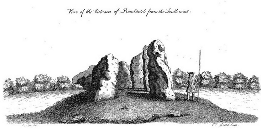
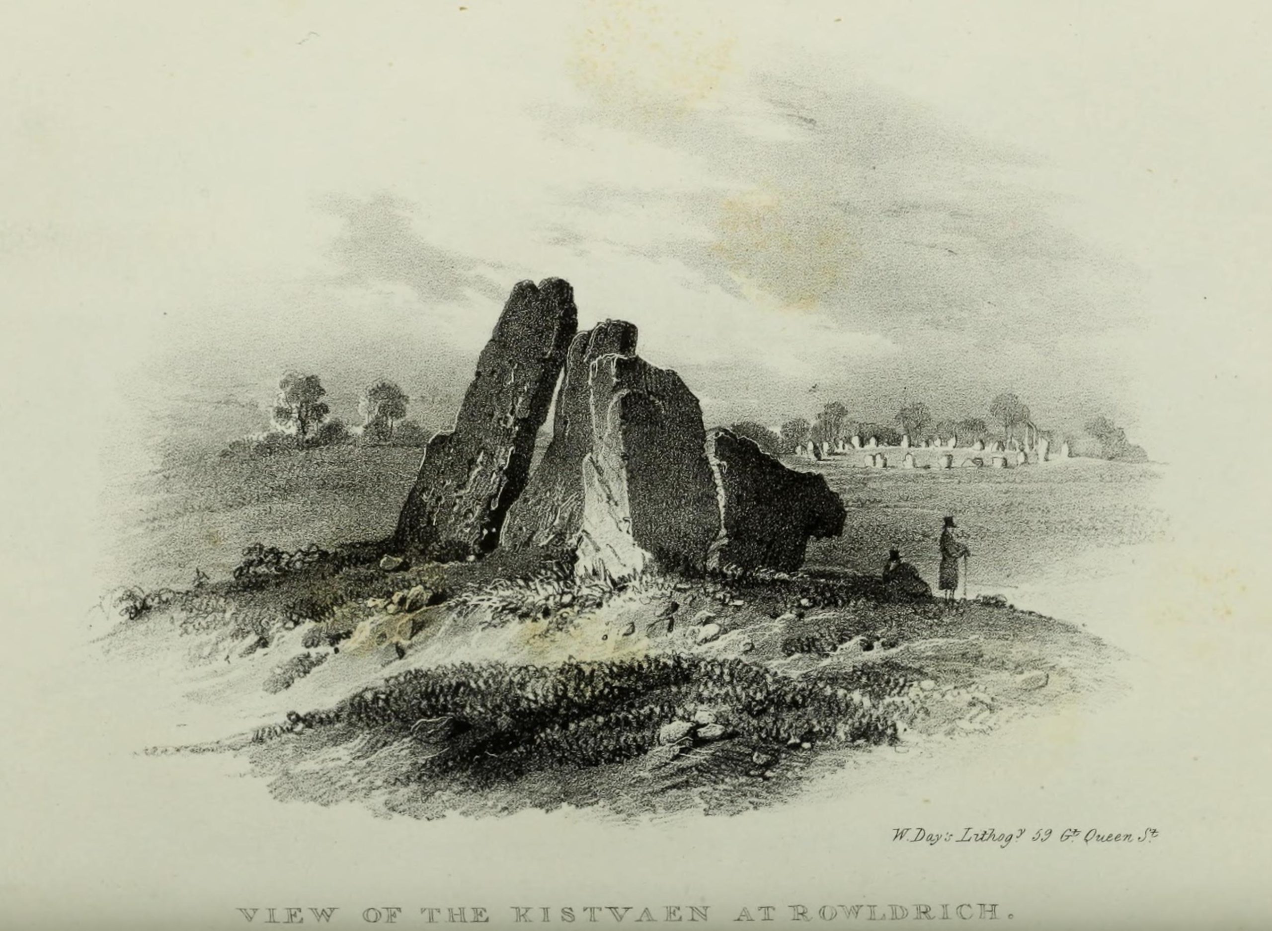
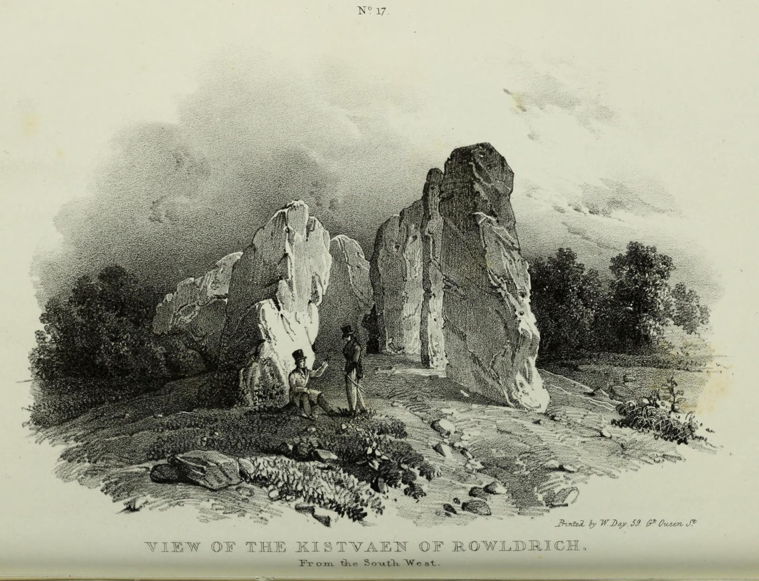
Although five stones remain of the site, when the great William Stukeley (1743) visited the Whispering Knights, he described six of them to be visible with the great stones here to be sat upon a tumulus, saying:
“Tis composed of six stones, one broader for the back part, two and two narrower for the sides, set square to the former; and above all, as a cover, a still larger. The opening is full west to the temple or Rowldrich. It stands on a round tumulus, and has a fine prospect southwestward down the valley, where the head of the Evenlode runs.”
O.G.S. Crawford (1932) told us of a description which Sir Henry Dryden gave of the Knights in 1898, when he wrote:
“About 356 yards E from the (Rollright) circle and S of the road, is the dolmen about to be described, called the Five Whispering Knights. It is in a ruinous state. It now consists of four stones, upright, or nearly so, and one prostrate, all of coarse limestone…
Height, 8ft 3ins (4ft by 2ft 6ins)
” , 7ft 3ins (3ft 6ins by 1ft 10ins)
” , 6ft 7ins (3ft 8ins by 1ft 4ins)
” , 5ft 4ins (4ft 9ins by 2ft)
Capstone (then fallen), 8ft 4ins by 5ft 9ins, by 2ft 4ins
“The chamber appears to have been about 5 feet 6 inches W and E, and the same N and S. If, as usual, there was an entrance, with or without a passage, it was probably to the ENE… There is not, so far as I know, any record of remains having been found in this dolmen. In a small stone pit about 700 feet NE by E from the circle it is stated that 12 skulls were found in 1835. In another stone pit near it was found in 1836 an urn and beads…”
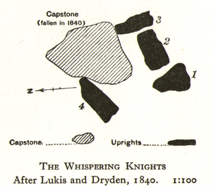
1840 plan by Lukis & Dryden
During the last century, very little has really changed at the Knights. The ring fencing surrounding the stones has kept it pretty much protected, despite it ruining all sense of healthy ambience. But they have gained greater and greater attention the older they have got. Archaeologists are not the only ones exploring the site. Fascinated astronomers, engineers and architects have been and seemingly uncovered other mythic ingredients here.
Whispering Knights, 2016
When the legendary Alexander Thom came here, he used the archaeological data that was being espoused at the time, which said the Knights and the Rollright stones had both been built around 1750 to 1800 BC. With these dates as his guide, he found that someone standing at the centre of the Rollright circle, on the morning of the equinoxes—March 21 and September 21—the sun would rise right above the Whispering Knights. And the effect, he thought, was a notable one: with the light from the rising sun going straight through a hole in one of the stones in the circle as it rose up behind the Knights. It would have looked both spectacular and eerie in the rising mists of first light, like a laser cutting through the still morning air… However, although Thom’s measurements were very accurate, the archaeologists had got their dates wrong. Very wrong! For the Whispering Knights were about 1500 years older than the stone circle—and so the alignments Thom pronounced, based on the archaeologist’s erroneous proclamations, were also incorrect.
There may be other alignments connected to the Rollright complex. In a survey of the site as part of the Dragon Project experiments conducted here in June 1980, Leslie Banks and Christopher Stanley flew over the place and found, adjacent to the Whispering Knights, a quite distinct “trace of two dark green parallel lines in a field of ripening corn” running northwest to the roadside. To this day nobody quite understands the nature of this enigmatic alignment:
“In the absence of excavation we can only speculate,” said Stanley. “But the most likely explanation is that it is what archaeologists refer to as a Cursus. Cursuses are thought to be prehistoric religious processional ways.”
As with many of the alignments described here, the jury is still out on this one!
Folklore
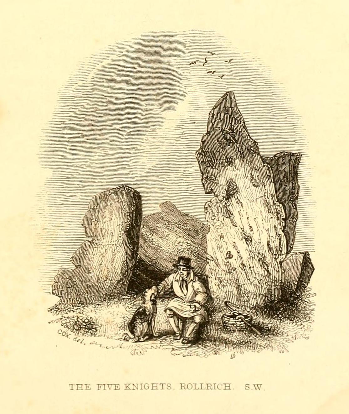
Whispering Knights, 1829
The folklore here is prodigious! The prime story of the neolithic tomb of the Whispering Knights tells that originally they were in fact a group of traitors who moved away from a King and his army in ages past, and who were plotting against him, when the great Witch of Rollright (a southern version of the great cailleach, found in more northern counties, Scotland and Ireland) turned them all to stone (this tale is intimately bound up with the King’s Men stone circle and the associated King Stone).
Whispering Knights, 1841
Another tale tells how the King Stone and the Whispering Knights venture, at midnight, less than half a mile south to drink from a spring in the small woodland at Little Rollright Spinney, although it is difficult to ascertain precisely which of the two springs the stones are supposed to visit. In some accounts, the stones reputedly drink from the well every night, but others tell that they only go there at certain times of the year, or on saint’s days. When Arthur Evans (1895) wrote of these tales he described there being a “gap in the bushes… through which they go down to the water,” but the terrain has altered since his day.
Other accounts imbuing the stones with life tell how they only ‘awaken’ when disturbed by humans. A story well-known to local people is that of when the Knights had its capstone removed one day by a farmer who used it to build a bridge across the stream at Little Rollright. As Evans told us,
“it took a score of horses to drag it down the hill, for at first it would not move, and they had to strain and strain to get it along till every bit of the harness was broken. At last they got it to the brook by Rollright Farm, and with great difficulty laid it across to serve as a bridge. But every night the stone turned over back again and was found in the morning lying on the grass.”
Three nights of this led the farmer to think he should replace the stone which, so the fable goes, took only one horse to move it back uphill and into position. A variation of the same tale was told by T.H. Ravenhill, who wrote:
“The Lord of the Manor of Little Rollright desired to possess the King’s Stone in order to bridge Little Rollright brook. So he dug it up and tried to cart it away, but found that he had not enough horses. He hitched on more, and yet more, and still he found that he could not move the stone. Finally he succeeded and hauled the stone away to the Manor House. The same night he was alarmed by strange sounds about the house, which he attributed to the presence of the King’s Stone, and decided, therefore, to replace it on its mound. No sooner had he harnessed the first horse to the cart than it galloped away up hill with ease, taking with it the stone, which leapt to position on reaching its resting place.”
There are still more variations that are worth mentioning. One from 1876,
“said that a miller in Long Compton, thinking the stone would be useful in damming the water of his mill, carried it away and used it for that purpose, but he found that whatever water was dammed up in the day disappeared in the night, and thinking it was done by the witches (at Long Compton) and that they would punish him for his impertinence in removing the stone, he took it back again; and, though it required three horses to take it to Long Compton, one easily brought it back.”
In yet another version, the stone was wanted by a local farmer for his outhouse. In taking it downhill, the horses that pulled his wagon died and the vehicle itself was irreparably damaged. It got even worse for the poor chap: his crops failed, his family were taken ill and his cattle died. Eventually when all but his last horse remained, he made another cart and it pulled the stone back uphill with ease. Thereafter, so the tale goes, all his adversities stopped and he lived a normal life. In one version of this tale, the great monolith was said to have been taken north-north-west down to the stream at The Hollows, Long Compton. Tales such as these are, once more, found throughout the world.
The truth of these stories was seemingly unquestionable to some local people in the 19th century,
“one man going as far as to say that there were those now living who had spoken to men who had helped to bring the stone down and up again.”
In William Stukeley’s day, one Farmer Baker was so troubled by his actions that he couldn’t rest until he returned the old stone.
The doyen of the early geodelic sciences or Earth Mysteries movement, John Michell, suggested how the legends of megaliths moving of their own accord harked back to ancient days when the people of those times were more attuned to the terrestrial magnetic flows of the Earth.
The Whispering Knights were also a place where “young girls of the neighbourhood (use it as) a kind of primitive oracle.” One local told Arthur Evans that around barley harvest the young women of the district visited the Five Knights to listen to them whisper. One at a time they would rest their ears against the strange shapes of stone and, if fortune and conditions were right, they would hear the future told. This mass of animistic lore is very revealing indeed, telling us much about the way our peasant ancestors viewed the living world around them. (Eliade 1958)
In more recent times, the site has been explored by dowsers and ley hunters, who claim to have found a veritable bags of fascinating lost material around the Knights. Although originally ‘leys’ were described by Alfred Watkins as quite acceptable prehistoric trackways linking site to site to site, in recent years the original theory has been ignored and superceded with a host of almost incredulous fluctuations. Leys these days can run just about anywhere – and do!
One writer who tells about the leys around Whispering Knights is Lawrence Main. (1997) He dowsed and found a ley running south to the famous White Horse at Uffington. Roy Cooper (1979) was the first person to write about this alignment and extended it further north to the impressive and legendary Brailles Hill. That one seems reasonable. However,
“Other leys I dowsed,” said Main, “Linked the King Stone, the stone circle, and the Whispering Knights with each other; the King Stone with Banbury Cross; the Whispering Knights with Hook Norton church; and the stone circle with the churches at Todenham and Stretton-on-Fosse.”
Another dowsing ley hunter is Dennis Wheatley (not The Devil Rides Out dood). He wrote a couple of short works on his lengthy experiments at the Rollright stones and reported how he found a
“tangential aerial energy course…across the country (which) latches on to a solitary standing stone, six miles south, known as the Hawk Stone.”
Perhaps of greater importance here is that Wheatley also discovered how,
“all of the Rollright ring’s stones engage in aerial energetic cross-talk with the King Stone producing a triangulation of energy lines.”
This cross-talk of Wheatley’s involves more than seventy energy lines running between the circle and the King’s Stone. He tells us that a greater “aerial cross-talk” also occurs between the circle and the Knights; and “a lesser energetic triangulation” runs between the King and the Knights.
Along similar lines are the findings of the dowser Reginald Smith. (1980) Beneath the Whispering Knights he claimed to have found,
“a concealed spring which runs underground to the northwest and may betoken a consecrated site; but 100 feet to the east there seems to be another blind spring with issue to the northeast.”
References:
Bennett, Paul & Wilson, Tom, The Old Stones of Rollright and District, Cockley Press: London 1999.
Burl, Aubrey, Great Stone Circles, Yale University Press: New York & London 1999.
Cooper, Roy, ‘Some Oxfordshire Leys,’ in The Ley Hunter 86, 1979.
Crawford, O.G.S., Long Barrows of the Cotswolds, John Bellows: Oxford 1932.
Devereux, Paul, Places of Power, Blandford: London 1990.
Devereux, Paul, The Sacred Place, Cassell: London 2000.
Eliade, Mircea, Patterns in Comparative Religion, Sheed & Ward: London 1958.
Evans, Arthur J., ‘The Rollright Stones and their Folklore (3 parts),’ in Folklore Journal, 1895.
Gelling, Margaret, The Place-Names of Oxfordshire – volume 2, Cambridge University Press 1971.
Graves, Tom, Dowsing: Techniques and Applications, Turnstone: London 1976.
Grinsell, Leslie V., The Ancient Burial Mounds of England, Methuen: London 1936.
Lambrick, George, The Rollright Stones: The Archaeology and Folklore of the Stones and their Surroundings, Oxford Archaeology Review 1983. (Reprinted and updated in 1988.)
Main, Lawrence, Walks in Mysterious Oxfordshire, Sigma: Wilmslow 1997.
Ravenhill, T.H., The Rollright Stones and the Men Who Erected Them, Little Rollright 1926.
Robins, Don, Circles of Silence, Souvenir Press: London 1985.
Smith, Reginald A., ‘Archaeological Dowsing,’ in Graves, Tom (ed.), Dowsing and Archaeology (Turnstone: Wellingborough 1980).
Stanley, Christopher C., ‘A Rollright Processional Way?’ in The Ley Hunter 90, 1981.
Stuart, Sheila, Lifting the Latch, Oxford University Press 1987.
Overgrown Pendreich 2 cairn (Pendreich 1 in background)
Take the same directions to get to the Pendreich 1 cairn. Once on the hilltop, look across the moor a short distance to the north and you can just see this overgrown site a couple of hundred yards away. From Pendreich 1 walk down the grassy slope and then up the gentle ahead of you, till it levels out a bit, keeping your eyes peeled for the change in vegetation and colour that gives the game away!
Archaeology & History
Like its companion cairns — Pendreich 1 & 3 — little has been said of the place. Although much overgrown and visible as a small bumpy grassy mass, with the stones beneath the surface, it’s never been excavated as far as I’m aware. It was referred to in the Scottish Royal Commission inventory for Stirlingshire (1963), site no.4, as ‘Mound, Sheriffmuir Road 1’, in which they wrote:
“Another possible Bronze Age cairn is situated on a low ridge, 200yd N of (Pendreich 1), and at a height of a little over 800ft OD. It is a grass-covered, stony mound which measures 20ft in diameter and stands to a height of 9in above ground level.”
References:
Royal Commission on the Ancient & Historical Monuments Scotland, Stirling – volume 1, HMSO: Edinburgh 1963.
Up, round the back of Stirling University, between Bridge of Allan to Greenloaning, take the steep zigzaggy Sheriffmuir Road uphill, until it levels out beyond the main wooded area where the hills open up on either side of you. There’s a little touristy parking spot further along the road, just below a small wooded bit. Keep going on the road for another ¾-mile, until you reach a small scattered copse of trees on your left. At the top of this copse, walk onto the moor on your left (west), following the old walling for more than another 500 yards, where a scatter of old trees live by the wallside. As this bends back downhill, note the rounded hill less than 100 yards above you (north). Go to the top of it!
Archaeology & History
There are several cairns hereabouts; yet despite several visits here, we still haven’t got round to checking them all out, as other little-known archaeological remains keep catching our attention (old walled structures and a possible enclosure). This is the most notable one of the bunch in the region — and easiest to find thanks to it being on top of the small hill where, many years ago indeed, was laid this small round rocky tomb of some long-dead chief, or granny, or someone!
There’s not been much written about this cairn, or its companions (Pendreich 2 & 3). It was referred to in the Scottish Royal Commission inventory for Stirlingshire (1963) where it’s listed as site no.3 as ‘Cairn, Sheriffmuir Road’, but their description is scant. They wrote:
“On a low ridge 800 yards WSW of spot-level 776 on the Sheriffmuir Road, and at a height of 800ft OD, there is a round cairn measuring 40ft in diameter and 2ft 8in maximum height. For the most part it is covered with grass, but a shallow depression in the centre, which may have been caused by excavation, reveals a few boulders.”
Pendreich cairn, looking westExposed section of cairn
Indeed! This cut into the centre of the cairn is somewhat larger than the 1963 description implies, as one of the images here shows. But the grassy mound is pretty clear and there’s certainly something buried beneath here.
The views from here are excellent and gave the spirits the usual panoramic flights across the land, as at many other ancient tombs. The great pyramidal hill of Dumyat rises to the east; and just a few hundred yards away to the north, we find the long laid-out standing stone of Pendreich Muir, whose mythic history has all-but been forgotten…
References:
Royal Commission on the Ancient & Historical Monuments Scotland, Stirling – volume 1, HMSO: Edinburgh 1963.
Go up through Baildon centre and head onto the moors. Crossing the cattle-grid, a coupla hundred yards further up, turn left. Past the small reservoirs on your left, another 100 yards or so and you reach the brow of the hill. As you begin going down the road, there’s a small car-park right by the roadside. The curious remains of the earthworks at the side of the old circle are discernible in the grassland right to its side.
Archaeology & History
Illustrated on the 6-inch OS-map of 1852 as “Site of a Barrow” (similar to how it appears in the image drawn here by Mr. C.N.M. Colls) a short distance below Pennythorn Hill top, there are still considerable traces of the earthworks surrounding the east and southern sides of what was once some form of ring cairn or tumulus that was once at this prominent place in the landscape.
Aerial view of siteThe site was first explored by Mr Colls in 1843 (his results were reported a few years later), who found a loose double-ring of stones, fifty feet across, surrounded by a shallow trench which was most notable on the south and east sides. Two urns were also uncovered near the centre of the ring, nearly two feet down, containing the cremated remains of people. A few years later, the Leeds historian James Wardell (1869) told a most fascinating note about what happened during their excavation, saying:
“This…examination was attended by a circumstance not soon to be forgotten by the persons engaged therein (on the excavation). They had almost reached the place where the broken urn and bones were deposited when, at once, such a fearful storm of thunder, lightning and rain came on, that they were not only considerably alarmed, but driven from the Common to seek shelter in the village.”
Colls’ 1846 sketch
We hear this sorta thing at many of our ancient places!
Colls 1846 plan
One anonymous writer in 1955 described the site as a ‘stone circle’, and a number of subsequent archaeologists copied this without question; but in all probability this site was more typical of an old cairn circle or ring-cairn, similar in size and design to the Roms Law circle two miles north of here. However, the earthworks at its side give the impression of some sort of exaggerated hengiform enclosure.
The place-name element howe strongly indicates a burial site and is a suffix found at many prehistoric tombs across northern England. The prefix ‘acre’ may relate to “a plot of arable or cultivated land, a measure of land (an acre) which a yoke of oxen could plough in a day” (Smith 1956), or may be a corrupted form of the Old English word, ‘acen’, relating to oak trees. Early literary examples of the place-name would enable a clearer understanding of the prefix element here.
References:
Anonymous, Colls’ Burial Mound Stone Circle, Baildon Moor, Museum Leaflets: Bradford 1955.
Baildon, W. Paley, Baildon and the Baildons (parts 1-15), St. Catherines: Adelphi 1913-26.
Barnes, Bernard, Man and the Changing Landscape, Eaton: Merseyside 1982.
Bennett, Paul, The Old Stones of Elmet, Capall Bann: Milverton 2001.
Colls, J.N.M., ‘Letter upon some Early Remains Discovered in Yorkshire,’ in Archaeologia, 31, 1846.
Collyer, Robert & Turner, J.H., Ilkley: Ancient and Modern, William Walker: Otley 1885.
Smith, A.H., English Place-Name Elements – volume 1, Cambridge University Press 1956.
Wardell, James, Historical Notes of Ilkley, Rombald’s Moor, Baildon Common, and other Matters of the British and Roman Periods, Joseph Dodgson: Leeds 1869. (2nd edition 1881)
When the Scottish Royal Commission lads came here in 1963, they reported seeing
“the remains of a short cist…set into the west side of a small turf-covered knoll some 18 metres north of the schoolhouse at Ardminish.”
It was first found during quarrying operations here, and was thankfully kept pretty well preserved, apart from the western slab, which was dislodged and fell to the foot of the knoll. The cist aligns roughly north-south (the airt, or cardinal virtue of ‘death’ is north) and measured about 3 feet long by 2 feet wide.
References:
Royal Commission on the Ancient & Historical Monuments, Scotland, Argyll: volume 1 – Kintyre, HMSO: Edinburgh 1971.
This is the highest point of the moors, 1320 feet up. There’s various ways of getting there: I’d favour the wander up to Twelve Apostles then taking the 15 minute walk west to the triangulation point which marks the spot. If you reach the large rocky outcrop of the Thimble Stones, you’ve gone too far; although you can walk past the Thimbles, if you’ve started your walk from the two radio masts atop of the moor where the old Roman road hits the dirt-track. Either way, unless you’re damn stupid, this is an easy spot to find!
Archaeology & History
Although today there’s little to be seen, when Collyer & Turner (1885) described the place it was 175 yards in circumference! Bloody huge! When Harry Speight got here in 1900, it had shrunk slightly to 150 yards. Now however, almost all the stones have been robbed. I first came here when I was just 11 years old and remember it was a decent size even then – at least as large as the Little Skirtful and Great Skirtful of Stones more than a mile to the east. Today however, unless you knew it was once a giant cairn, you wouldn’t give it a second look.
It’s quite appalling what’s happened to this site thanks to the sheer ignorance and neglect of the local archaeologist in tandem with his paymasters at Bradford Council: 90% of the site has been utterly vandalised and destroyed as a result of these incompetent idiots in the last 20 years. Nowadays, all you can make out here is the raised earth for about 10 yards surrounding the trig-point. It seems that most of the stones that comprised this giant cairn have been taken for use in walling, and to prop up the stupid paved footpaths which the local Council and its affiliated halfwits are slowly building o’er these hills.* Morons!
Aar Dave on top o’ t’ moors
I’m not quite sure why it was called Nixon’s Station. It was J. Atkinson Busfield (1875) who mentioned this name, quite casually in his fine local history work, as if local folk had known it as such for sometime. There was also an inference of it being the resting place of some old general, but I’ve found nor heard anything more along such lines — though worra superb place for your spirit to roam free…..
If anyone has any old photos of this once giant prehistoric site, it would be good to see it in its old glory once again. When I wandered up here as a kid, I never carried things like a camera about (being a Luddite by nature!).
References:
Busfield, J.A., Fragments Relating to the History of Bingley Parish, Bradford 1875.
Collyer, R. & Turner, J.H., Ilkley, Ancient & Modern, Otley 1885.
* Anyone know exactly which idiots are responsible for the stone footpaths being laid over the moors here? They’re damn stupid and cause even more erosion and damage to the environment and prehistoric heritage up here, as anyone with an ounce of common sense can see. Can someone please get them stopped!?
Park up at the Nick of Pendle and follow directions to the Devil’s Apronful of Stones, but about halfway along the path, bear to the right along a swerving footpath which eventually takes you to another guiding cairn. On the OS-maps there’s the Chartist’s Well 100 yards due west of this old overgrown tomb.
Archaeology & History
The much-overgrown Lower Apronful cairn
Seemingly excluded from all previous archaeological surveys, this is a very large structure indeed. Crowned with a small modern cairn on its top marking a small footpath crossing the site, this very large cairn-like structure is about four feet tall at the highest. I first came across it at the end of August, 2006, after going through some folklore records which then led to exploring the area in the hope that there might be some archaeological ruins in the region — and we weren’t to be disappointed!
Outline of extended monument
This giant cairn structure is larger than the denuded remains of the Devil’s Apronful cairn that can be seen a few hundred yards further uphill, but is almost entirely overgrown with grasses. It measures at least 31 yards (east-west) by 29 yards (north-south) and is just like an overgrown Little Skirtful of Stones on Burley Moor. Parts of its eastern side have been dislodged and the main rock structure is plainly visible where the vegetation has come away. A ringed embankment is also very clear, mainly on the north and eastern sides of this large structure (as one of the photos here shows), but on the whole it is overgrown and ruinous. It’s a brilliant spot though and sorely needs some proper archaeological attention. In the event that this site aint a prehistoric cairn, please lemme know so I can delete it from TNA.
Follow the same directions for getting to the Black Hill Round Cairn. It’s less than 100 yards away – you can’t miss it!
Archaeology & History
This is a superb archaeological site — and it’s bloody huge! It’s big and it’s long and it sticks out a bit – which is pretty unique in this part of the Pennines, as most other giant cairns tend to be of the large round variety. Although the site was originally defined by Arthur Raistrick (1931) as a long barrow, J.J. Keighley (1981) told how, “it was found to be a round cairn imposed on a long cairn.” And it’s an old one aswell…
Near the SE end of the giant cairnClose-up of the main cist
More than 220 feet long and 80 feet in diameter at its widest southeastern end, as we walk along the length of the cairn to its northwestern edge, its main body averages (only!) 45 feet in diameter. Made up of tens of thousands of rocks and reported by Butterfield (1939) to have had an upright stone along its major axis, the “height varies from 4-8ft, but the cairn has been much despoiled and disturbed,” said Cowling in 1946. He also told how,
“Excavation revealed that almost in the centre of the mound were the remains of a cist made of roughly dressed stone flags and dry walling, covered by a large stone. Under a stone slab, laid on the floor of the cist, were fragments of (burnt and unburnt) bone and a small flint chipping.”
This is a very impressive site and deserving of more modern analysis. The alignment of the tomb, SE-NW, was of obvious importance to the builders, believed to be late-neolithic in character. The tomb aligns to two large hills in the far distance in the Forest of Bowland which we were unable to identity for certain. If anyone knows their names, please let us know!
Folklore
The older folk of Bradley village below here, tell of the danger of disturbing this old tomb. In a tale well-known to folklorists, it was said that when the first people went up to open this tomb for the very first time, it was a lovely day. But despite being warned, as the archaeologists began their dig, a great storm of thunder, lightning and hailstones erupted from a previously peaceful sky and disturbed them that much that they took off and left the old tomb alone. (I must check this up in the archaeo-records to see if owt’s mentioned about it.)
References:
Ashbee, Paul, The Earthen Long Barrow in Britain, Geo Books: Norwick 1984.
Butterfield, A., ‘Structural Details of a Long Barrow on Black Hill, Bradley Moor,’ in YAJ 34, 1939.
Cowling, E.T., Rombald’s Way, William Walker: Otley 1946.
Keighley, J.J., ‘The Prehistoric Period,’ in Faull & Moorhouse’s West Yorkshire: An Archaeological Survey, I, WYMCC: Wakefield 1981.
Raistrick, Arthur, ‘Prehistoric Burials at Waddington and Bradley,’ in YAJ 30, 1931.