Standing Stone (lost): OS Grid Reference – SU 161 432
Archaeology & History
In William Stukeley’s Stonehenge, he described a number of monoliths outlying Salisbury Plain that also possessed a prehistoric pedigree. Most of them have been recorded, but this one seems to have been forgotten about — perhaps by virtue of it having fallen into the River Avon! Edgar Barclay (1895) described it in his fine survey, saying:
“In the bend of the river below the village, is a large submerged stone; only during drought is any portion of it visible above water; it can, however, in ordinary times, be dimly seen from the bank, which is of chalk, here very steep and overgrown. The country people assert that a metal ring, “turning always,” is let into its upper end. Legend relates that when the Devil brought the rocks of Stonehenge from Ireland, tied together with withes, this stone escaped from the bundle and fell into the river. Its position forbids the belief that it got fixed in the bed of the stream when its passage to Stonehenge was being attempted, for it lies immediately beneath the crest of a very steep bank, and at its most inaccessible point; as the stream sweeps against this, the water must always have been deep at this spot, the open valley would everywhere offer more favourable points for such an operation, especially would this be the case before the Avon was dyked. A boundary stone would have been placed on the brow of the hill; if the stone be a grey-wether, as report says, and as is probable, it may originally have stood on the bank, and “once upon a time”, a ring having been fixed in it, it may have been dragged into the stream to moor a ferry-boat. It lies closely midway between the stone on Bulford Down and that in Durrington fields.”
One wonders if any local people might know more about this…
References:
Barclay, Edgar, Stonehenge and its Earth-works, D. Nutt: London 1895.
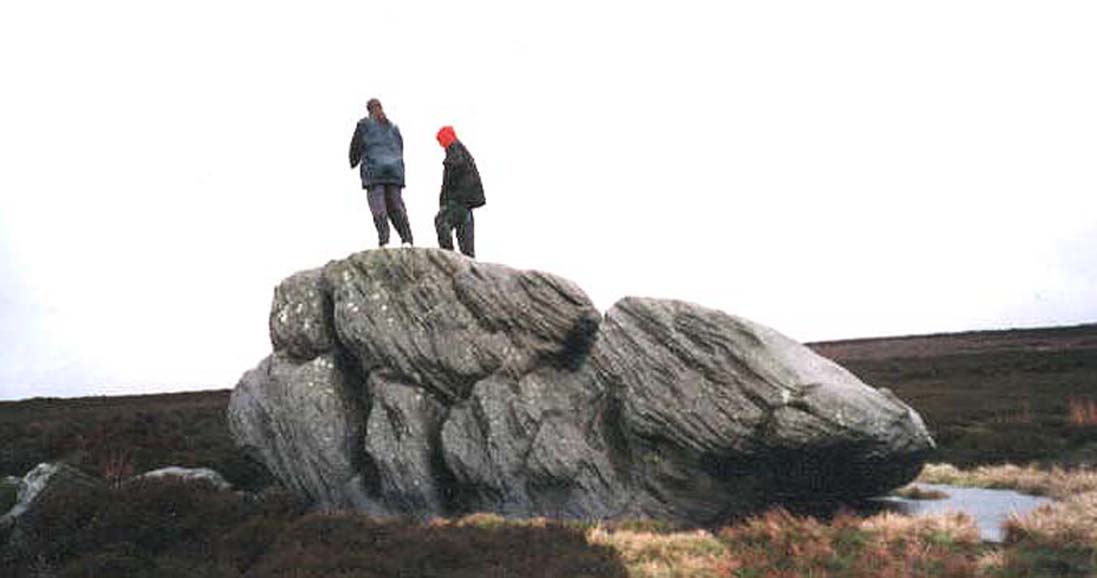
By whichever route you wanna take, get y’self to the prominent cup-and-ring marked rocks known as the Thimble Stones near the very top of these moors. From here, walk roughly 400 yards southwest onto the bare open moors (there are no footpaths here) and you’ll see these two isolated prominent boulders living quietly on their own. You can’t really miss ’em! You’re there.
Archaeology & History
Of the two giant boulders here, both are included in the petroglyph surveys of Hedges (1986) and Boughey & Vickerman’s (2003) as possessing “all natural” cup-marks on their top and vertical surfaces. Those on top of the rocks certainly seem to be Nature’s handiwork, whilst many of the seeming ‘cups’ on the vertical face of one (not the one pictured here) are due to gunshots. I’m not quite sure when they were done, but they certainly didn’t exist during the many visits I made here in the in the 1970s and ’80s.
They stones included in most of the standard antiquarian surveys of the 19th century, with the earliest being Forrest & Grainge (1869) who described them as,
“two detached masses of rock, standing alone upon the moor. The first is 14ft in length by 8ft in height, tapering to the ground; a set of cups and channels occupy the highest point. The other, distant 13 yards, is of an irregular square form, 45 yards in circumference and 7ft high. This stone appears to be tilted on its edge, presenting its cleavage upwards, and has hollows containing water, but is so much wasted above that if it has ever borne the cups and channels, they are now obliterated.”
On top of an Egg, c.1986
Collyer & Turner (1885) described “a number of cups” on the edge of the northern rock; and Romilly Allen (1896) likewise. Even that historical literary giant, Harry Speight (1900), added his own tuppence here, telling folks how both Eggs “are channelled and bear cups.”
It’s very possible that these isolated stones did have some sort of significance to our prehistoric ancestors. There are innumerable examples worldwide of rocks like this possessing ritual and mythic lore—and many in the British Isles too. And the cupmarks on the stones may have been enhanced by those same prehistoric ancestors. But we’ll never know for sure…
Folklore
The creation myth behind the Two Eggs is one echoed in traditions across the world. Folklore tells that the Eggs were said to have been laid here by a great dragon who lived within a hill some distance to the south. All other aspects of the tale have sadly long since been forgotten…
References:
Allen, J. Romilly, “Cup and Ring Sculptures on Ilkley Moor,” in The Reliquary, volume 2, 1896.
Bennett, Paul, The Old Stones of Elmet, Capall Bann: Milverton 2001.
Boughey, Keith & Vickerman, E.A., Prehistoric Rock Art of the West Riding, WYAS: Wakefield 2003.
Collyer, Robert & Turner, J.H., Ilkley: Ancient and Modern, William Walker: Otley 1885.
Forrest, Charles & Grainge, William, A Ramble on Rombald’s Moor, Northern Antiquarian: Bradford 2012 (1st published 1867-69).
Hedges, John (ed.), The Carved Rocks on Rombalds Moor, WYMCC: Wakefield 1986.
Speight, Harry, Upper Wharfedale, Elliott Stock: London 1900.
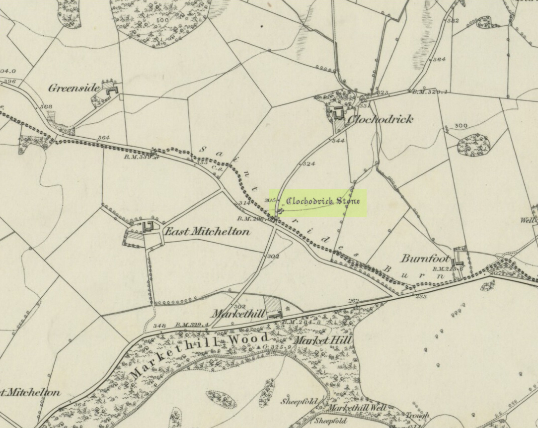
On the outer southern edge of Kilbarchan parish—right near the ancient boundary line itself—this giant stone of the druids is seems to be well-known by local folk. Located about 40 yards away from the sacred ‘St Bride’s Burn’ (her ‘Well’ is several hundred yards to the west), it was known to have been a rocking stone in early traditions, but as Glaswegian antiquarian Frank Mercer told us, “the stone no longer moves.” The creation myths underscoring its existence, as Robert Mackenzie (1902) told us, say
“This remarkable stone, thought by some to have been set up by the druids, and by others to have been carried hither by a glacier, is now believed to be the top of a buried lava cone rising through lavas of different kind.”
Clochoderick Stone on 1857 map
The site was highlighted on the first OS-map of the area in 1857, but the earliest mention of it seems to be as far back as 1204 CE, where it was named as Clochrodric and variants on that title several times in the 13th century. It was suggested by the old place-name student, Sir H. Maxwell, to derive from ‘the Stone of Ryderch’, who was the ruler of Strathclyde in the 6th century. He may be right.
Folklore
Folklore told that this stone was not only the place where the druids held office and dispensed justice, but that it was also the burial-place of the Strathclyde King, Ryderch Hael.
References:
Campsie, Alison, “Scotland’s Mysterious Rocking Stones,” in The Scotsman, 17 August, 2017.
MacKenzie, Robert D., Kilbarchan: A Parish History, Alexander Gardner: Paisley 1902.
Acknowledgements: Big thanks to Frank Mercer for use of his photos and catalytic inception for this site profile.
Standing Stone (destroyed): OS Grid Reference – NG 520 144
Folklore
This once-famous standing stone appears to have gone. It was described in Otta Swire’s (1961) superb book on the folklore of Skye, where she wrote:
“Overlooking Elgol is Bidein an Fhithich. Near here once stood the famous Raven’s Stone, about which the Brahn Seer prophesied. It is believed that this prophecy, however, can never be fulfilled, as seventy or eighty years ago the stone was broken up and the main portion of it is now incorporated in one wall of the Glendale church, according to the Rev. A. R. Forbes’ Place Names of Skye. The stone was believed to have had some connexion with old pagan religious ceremonies.”
The Brahn Seer (more commonly known as the Brahan Seer) was Coinneach Odhar, a 16th century prophet who is said to have foretold the Battle of Culloden and other events.
References:
Swire, Otta F., Skye: The Island and its Legends, Blackie & Sons: Glasgow 1961.
Seems rather daft giving directions for a mountain, but… For incomers, cross the bridge onto the island and keep on the A87 road to Broadford. A couple of mile the other side of the village westwards, take the small left turn in the trees and go to the dead-end. The hill reaching up above you (west) is the legendary mountain to walk up!
Folklore
Beinn na Cailleach
This giant old mountain has been associated with the primal female creation figure, the cailleach, for many a moon. And strangely – for me anyway – I’ve not ventured to sleep with this old place in my passings here as I usually do wherever the cailleach resides.
It doubtless has many more tales than the one A.A. MacGregor (1937) mentions in his superb Peat-Fire Flame. Here he tells the story of,
“the cairn situated on the summit of Beinn na Cailleach, not far from Broadford… This cairn is believed to mark the site of burial of a Norse princess who died at Ord. On her deathbed this princess commanded her attendants to convey her, when dead to the top of Beinn na Cailleach, and to bury her there, in order that she might lie in the wake of the winds from Norway.”
MacGregor then follows the tale with a lovely note on some boring old dood he obviously had little respect for, saying:
“It is the traditions associated with this cairn that MacCulloch, the geologist, in his Description of the Western Isles of Scotland, asks to be excused from repeating, since he considers them, one and all, to be unworthy of regard. But, then, MacCulloch was a most tiresome fellow; and he seems to have imbued most of his writings with something of the same tiresomeness”!
On the lower northeastern slopes of this great mountain we find another of the old woman’s abodes, the ‘Lochain Beinn na Cailleach’, where this great hag would no doubt wash her linen, as many old myths tell she did at other pools of the same name.
A slightly different version of the folktale was told by Archibald Geikie in his Note-book of a Field Geologist from 1858:
“The top of Beinn na Cailleaich is flat and smooth, surmounted in the centre by a cairn. Tradition tells that beneath these stones there rest the bones of the nurse of a Norwegian princess. She had accompanied her mistress to “the misty hills of Skye,” and eventually died there. But the love of home continued strong with her to the end, for it was her last request that she might be buried on the top of Beinn na Cailleaich, that the clear northern breezes, coming fresh from the land of her childhood, might blow over her grave.”
An early essay in the Gentleman’s Magazine in 1841 tells the grave atop of the mountain to have been the resting place of the Norwegian King Haco’s wife or his nurse. Derek Cooper (1970) meanwhile told us that whilst the cairn was “erected as a memorial to a Skye chieftain,” the cailleach of the mountain, or “the old woman is reputedly Saucy Mary, who laid a chain between Kyle and Kyleakin to exact toll from passing ships.”
There are other mythic place-names scattered around the edges of this mountain with hints of ancient female deities, or pagan goddesses — whichever way one cares to see them.
References:
Cooper, Roy, Skye, Routledge: London 1970.
Geikie, Archibald, The Story of a Boulder, MacMillan: London 1858.
MacGregor, Alisdair Alpin, The Peat-Fire Flame: Folk-Tales and Traditions of the Highlands and Islands, Ettrick Press: Edinburgh 1937.
o’ Crualaoich, Gearoid, The Book of the Cailleach, Cork University Press 2003.
Swire, Otta F., Skye: The Island and its Legends, Blackie & Sons: London 1961.
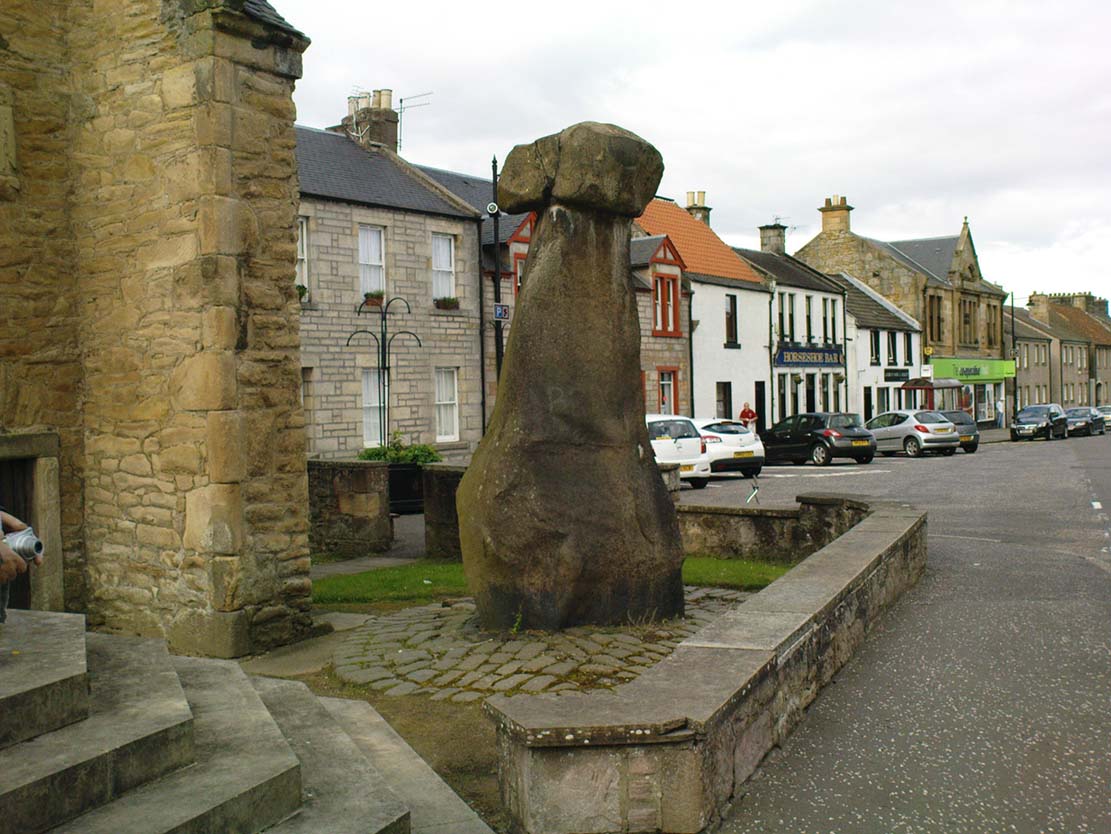
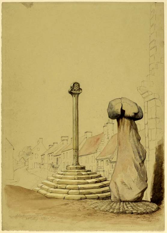
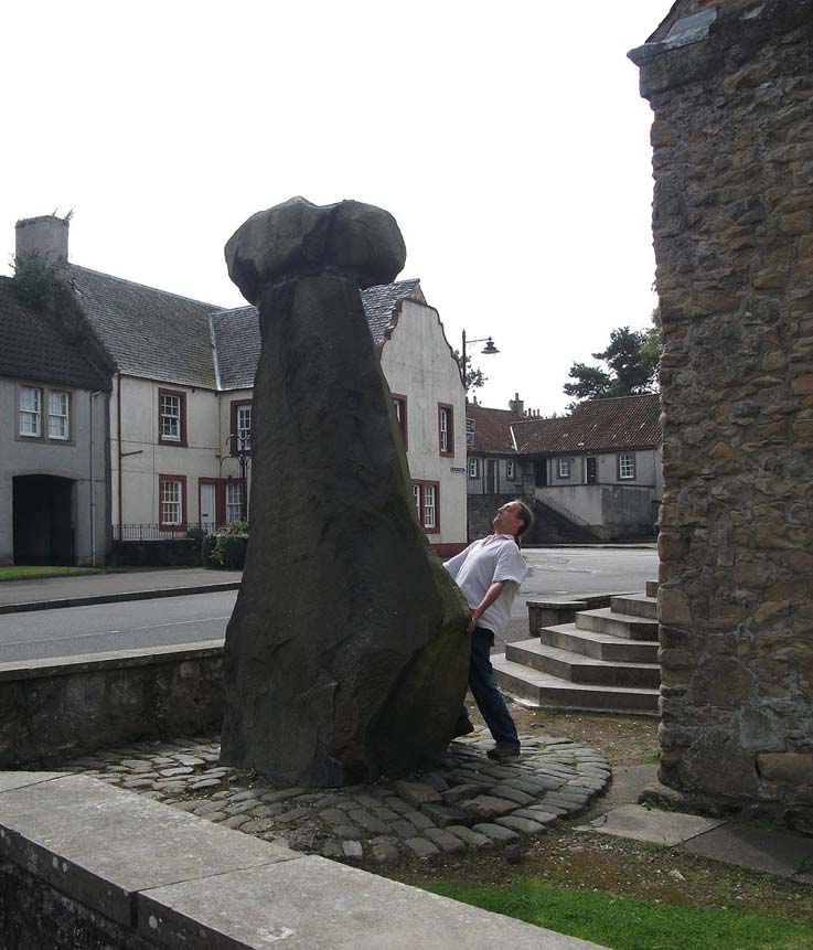
Take the A907 road between Alloa and Kincardine, and up the B910 into Clackmannan. To get into the village, depending on which route you’re coming in, go up the Kirk Wynd or the Cattle Market—both of which lead you to the Main Street where, beneath the old clock tower, you’ll see the Market Cross and its companion erection just to the side. You can’t really miss it!
Archaeology & History
The phallic upright!
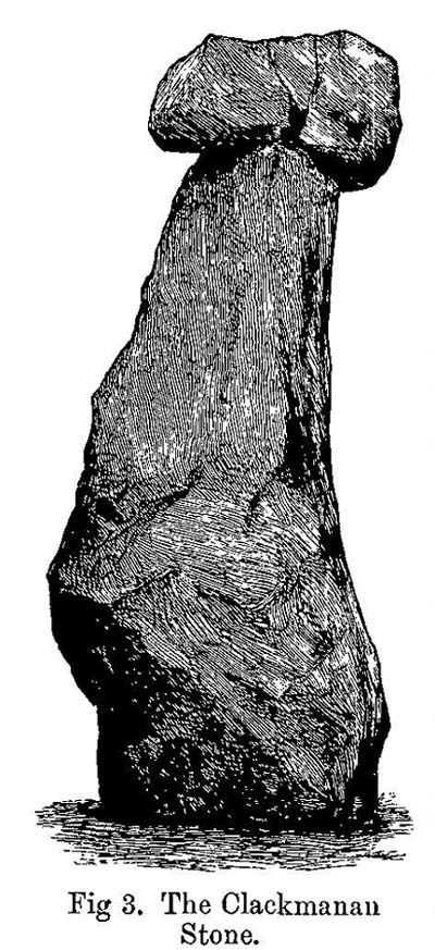
The history of this curious-looking giant phallic stone, sat quietly on the Main Street of sleepy Clackmannan village, isn’t as heathen as you’d expect when first seeing the huge upright—but there are mysteries and myths gathered about it. The county of Clackmannan itself takes its name from this stone—but not the entire stone that we see today; merely the rounded, smaller element on top. For it’s this that’s the real Mannan Stone. The rest of it, the tall upright pillar, was only attached to the smaller rounded stone—the Stone of Mannan— in the first-half of the 19th century.
First mentioned as a place-name in 12th century writings, the story of the stone was best told by Peter Miller (1889), who wrote:
“The old ‘clack’ or stone that forms the prefix to the name-word Clackmananmust be of considerable antiquity. Its form and appearance have nothing to excite remark. The two larger portions of the stone are battened together with iron, and the portion forming the cleft appears to be detached from the larger one. It is only the legend or tradition respecting its history and its association with the name-word Clackmanan that makes it interesting to the antiquary. Its dimensions are as follows: —It is over 3 feet in length, 2 in breadth, and about the same in thickness. Its form is oval, and it has a deep cleft on its upper side. The stone has nothing peculiar about it to indicate what it may have been originally, or the uses it was made to serve in early times. There is no appearance of its ever having had an inscription or any ornamentation upon it. It is simply a boulder-stone stone of whinstone, such as are found in abundance at the Abbey Craig near Cambuskenneth. It was placed on the tall boulder slab on which it now stands, brought from the Abbey Craig in the year 1833 by the late Robert Bruce of Kennet, and the late Professor Fleming, who was then minister of the parish. Previous to that time it lay on the ground alongside of the old jail and court-house of Clackmannan, close by the old cross of the town…”
Clackmannan Stone (after Miller)
The old stone & its upright
Mr Miller then went on at some length to show the derivation of ‘Clackmannan’ to be from the old Irish, meaning “the stone of the monks.” It seems a plausible theory too. Despite this, Watson (1926) deemed it to be the ‘Stone of Manau’, being deemed vaguely as the people of the land north of the Forth. The great Celtic scholar John Rhys (1888) declared Clackmannan to derive from the Irish deity or hero-figure, Manannan, as have other academic authorities since then. But it’s all just a bit vague if we’re wanting ‘certainty’…
When T.C. Crouther (1936) wrote about this, he said how the Stone of Mannan had originally come from a position only a few hundred yards south of its present spot, at a place known as Lookabootye Brae (NS 912 911), just above where the land begins to drop down closer to sea level. This doesn’t seems too improbable. Close to this spot could once be seen the sacred site of the Lady Well.
At the turn of the 21st century the stone was caged by the local council as it was beginning to crumble and was in danger of collapse; and so, the local council repaired the great upright and its sacred top-stone—albeit at the staggering cost of £160,000!!! As the local people and other masons know to this day, the job could have been done for a fraction of that cost with equal efficiency.
Folklore
Said by T.C. Crouther (1936), the local council, and others to have got its name from the sea god Mannan, other legends have grown around this fascinating old rock. When Edwin Adams (1863) wrote about it, these were the tales that local people gave him:
“Its legendary history is curious. When King Robert Bruce was residing in Clackmannan tower, and before there was a town attached to that regal mansion, he happened, in passing one day near this way on a journey, to stop awhile at the stone and, on going away, left his glove upon it. Not discovering his loss till he had proceeded about half-a-mile towards the south, he desired his servant to go back to the clack (for King Robert seems to have usually spoken his native Carrick Gaelic), and bring his mannan, or glove. The servant said, ‘If ye’ll just look about ye here, I’ll be back wi’t directly,’ and accordingly soon returned with the missing article.
£From this trivial circumstance arose the name of the town which was subsequently reared about the stone, as also that of a farm at which the King stopped, about half-a-mile from the south, on the way to Kincardine, which took its name from what the servant said, namely, ‘Look about ye,’ and is so called to this day.”
But as the various dates in this tale simply don’t add up, it seems that the writer had been easily fooled.
Rhys, John, Lectures on the Origin and Growth of Religion as Illustrated by Celtic Heathendom, Williams & Norgate London 1888.
Royal Commission on the Ancient & Historical Monuments, Scotland, Inventory of Monuments and Constructions in the Counties of Fife, Kinross and Clackmannan, HMSO: Edinburgh 1933.
Royal Commission on the Ancient & Historical Monuments, Scotland, The Archaeological Sites and Monuments of Clackmannan District and Falkirk District, Society of Antiquaries of Scotland 1978.
Simpkins, John Ewart, County Folklore – volume VII: Examples of Printed Folk-Lore Concerning Fife, with some Notes on Clackmannan and Kinross-Shires, Folk-Lore Society: London 1914.
Small, John W., Scottish Market Crosses, Eneas Mackay: Stirling 1900.
Watson, W.J., The History of the Celtic Place-names of Scotland, Edinburgh 1926.
Standing Stones (destroyed?): OS Grid Reference – NZ 9171 0952
Also Known as:
Robin Hood’s Pillars
Archaeology & History
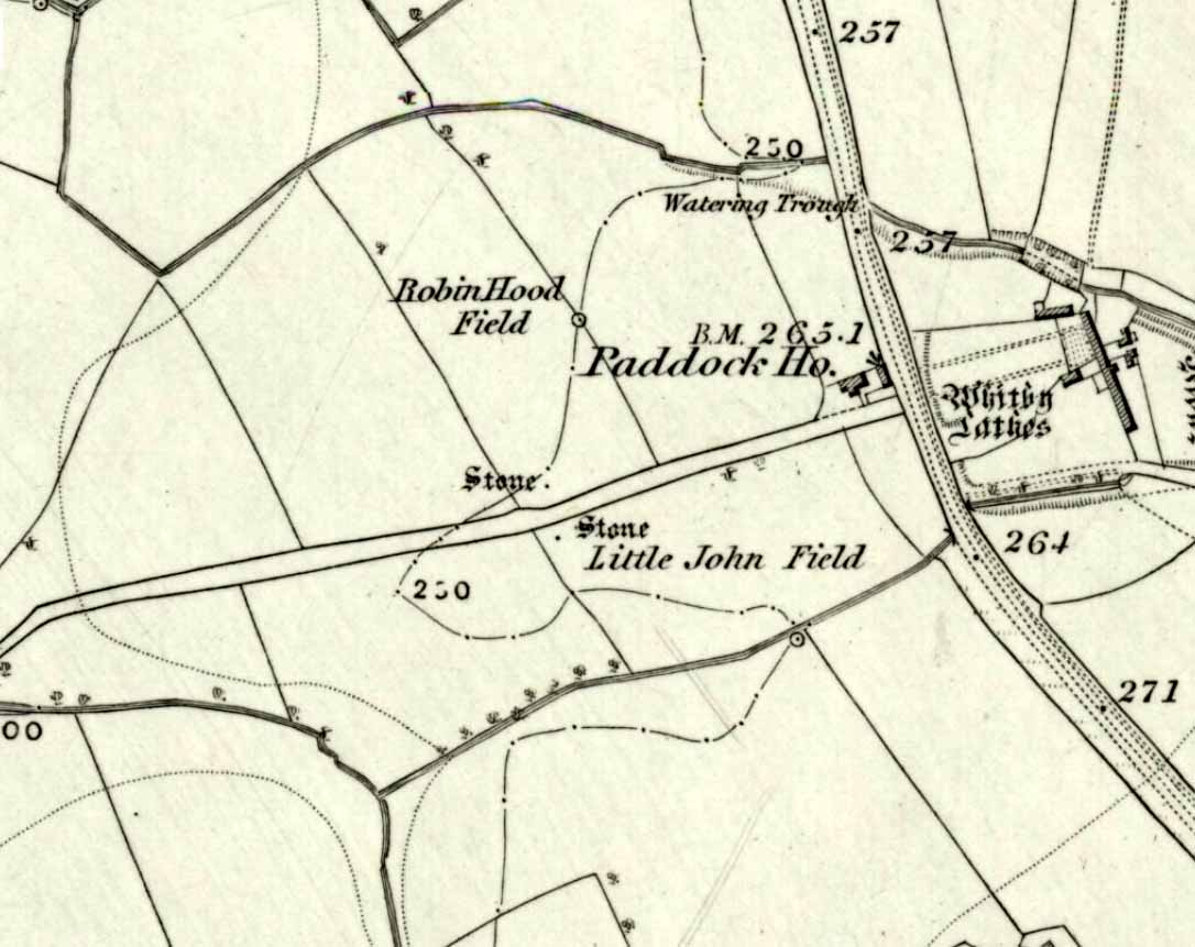
The 2 stones on 1853 map
References to these old standing stones are scarce—at least in archaeology books anyway. Even the usually diligent masters of Burl (1993) and Thom (1990) missed them! But thankfully our folklorists and antiquarians with their keen interest in popular culture have written about these long lost monoliths, which could once be seen in fields just a mile or so south of Whitby town.
The earliest known account of the site is as the “Robyn-Hood-stone” in records dating from 1540 CE cited in the Cartularium Abbathiae de Whiteby (1881). It was later described in land registers in 1713 and the fields in which they stood were—and still are—respectively known as Robin Hood’s Close and Little John’s Close.
These Whitby monoliths—like their namesakes in Northamptonshire— weren’t too big. In Mr Young’s (1817) early description, when the stones were still visible, he told how Robin Hood’s stone was “a stone pillar about a foot square and four feet high”, and Little John’s Stone was “a similar pillar about two-and-a-half feet high.” Mr J.C. Atkinson, the editor of the Cartularium (1881), also told that the two stones were “still in situ in the earlier part of the present century,” continuing:
“Both stones have now been removed, and are, I was informed, set up again near the enclosing fence of the field in which they stood. Almost beyond question , like the other monoliths of the district, they marked the site of ancient British interments.”
So—do the remains of these old stones still exist somewhere close by as J.C. Atkinson said, either in the walling, as a gatepost, or just pushed over and now covered in grass (like the long lost Thief Thorne standing stone near Addingham)? Are any northern antiquarians living close by who might enable their rediscovery?
Folklore
A number of writers exploring the mythic histories of Robin Hood have included this site in their surveys, usually repeating the earlier creation myths about them that could be heard in popular culture. The Whitby historian George Young (1817) told the tale:
“According to tradition, Robin Hood and his trusty mate, Little John, went to dine with one of the Abbots of Whitby, and, being desired by the Abbot to try how far each of them could shoot and arrow, they both shot from the top of the Abbey, and their arrows fell on the west side of Whitby Laithes, beside the lane leading from thence to Stainsacre; that of Robin Hood falling on the north side of the lane and that of Little John about a hundred feet further, on the south side of the lane.”
Whitby folklorist P.S. Jeffrey (1923) took this myth literally, saying how the distance of the arrows fired by the respective folk heroes was “scarcely credible, as the distance in each case is about a mile-and-a-half.” However, the earlier historian Lionel Charlton (1779) thought the incredible feat quite credible!
The distance between the Abbey and the stones is 1.36 miles (2.2km); but it may be that the direction related in the tale was more important than the distance, as the alignment between the two sites runs northwest to southeast—or southeast to northwest, whichever you prefer!—and may relate to an early astro-archaeological alignment. Might…..
References:
Anonymous, “Robin Hood in Yorkshire“, in Yorkshire Folk-Lore Journal – volume 1, T.Harrison: Bingley 1888.
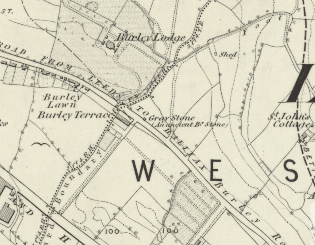
Originally located at SE 28449 34364, the site is now to be found halfway along Westfield Road, where it meets up with Hollis Place, along the footpath at the back of the school, set back against the walling. A plaque by the rock kinda gives the game away!
Archaeology & History
Gray Stone on 1852 map
The large vandalised stone you see here—sprayed-painted quite eloquently it has to be said!—is apparently a replica of the old stone which could once be found about 300 yards northwest of here. Typifying stones of this name—gray, grey and variants thereof—the original Gray Stone was an old boundary marker (Smith 1956), and the last reference to it as an archaeological site was by James Wardell (1853), who even in his day said that it was “almost buried in the ground, on the Burley Road.” It is shown on the first OS-map by the roadside, close to the junction of Woodside View and Burley Road, but was said to have been removed at the beginning of the 20th century and moved to its new and present position. However, somewhere along the line, the original stone has been destroyed and the thing that we see today has taken its place.
The original Gray Stone may have been a standing stone, but we cannot be certain about this. The present boulder stands about four feet tall and is a rather fat-looking standing stone. You can just about squeeze round the back of it, around which is an incised line which cuts around the stone – but this obviously quite modern. A plaque stands in front of the stone, telling its brief history. (if anyone can send us some photos of the site that would be great – I’ve gone and lost mine, somehow!)
Folklore
A creation myth of this site tells it to have been made by a giant, who threw the Gray Stone from the appropriately named Giant’s Hill (a supposed old camp, now destroyed), less than a mile southeast of here: an alignment which corresponds closely to the midsummer sunrise. In throwing it, he was said to have left the indentations of his finger-marks in the rock – thought to have been cup-markings. Examples of other cup-and-ring stones occur a short distance west, at Kirkstall.
References:
Bennett, Paul, The Old Stones of Elmet, Capall Bann: Milverton 2001.
Smith, A.H., English Place-Name Elements – 2 volumes, Cambridge University Press 1956.
Wardell, James, The Antiquities of the Borough of Leeds, John Russell Smith: London 1853.
Holy Well (destroyed): OS Grid Reference – TQ 3096 8106
Archaeology & History
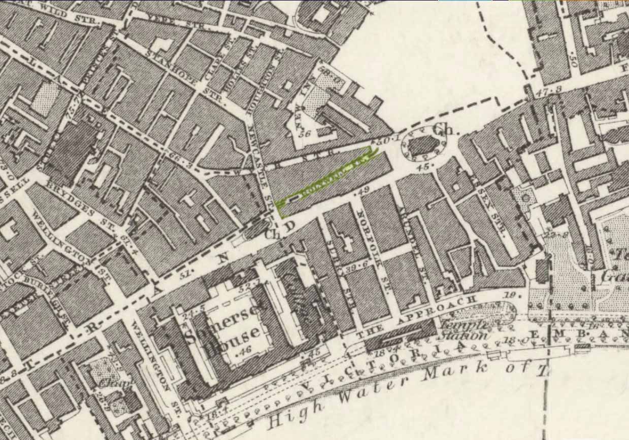
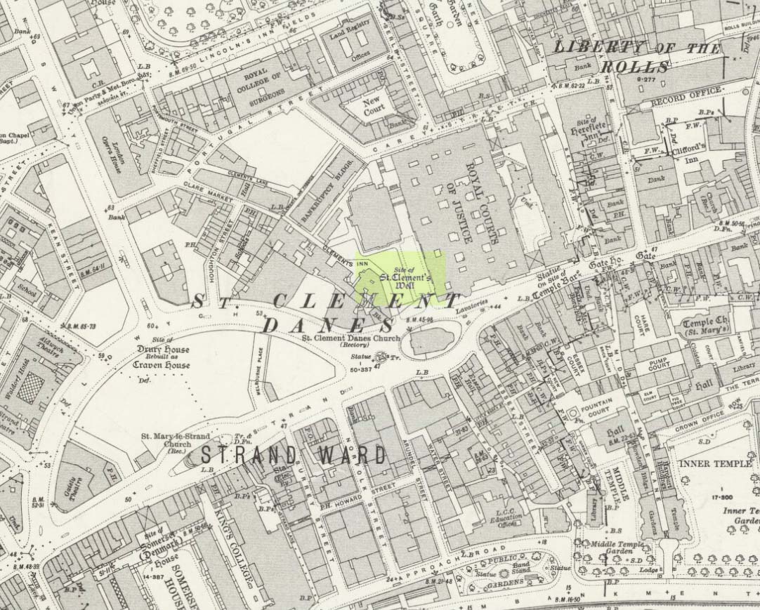
Close to the long-lost Strand Cross and long-lost Strand Maypole, in bygone centuries was also to be found a holy well of great repute, dedicated by early christians to the sea-faring St. Clement. Its presence was recorded in the ‘Holywell Street’ name at far the eastern end of The Strand but, like its compatriot monuments, it too is long-lost… Thankfully we have reasonably good accounts of its existence, although its precise whereabouts has been something of a matter of debate.
Holywell Street on 1868 mapSt Clements Well on 1914 map
The site is certainly of considerable antiquity, as evidenced in the early citations of the street-name ‘Holywell Street’. The earliest reference is found in legal records from 1373, where it was described as “viam regiam que vocatur Holeway“, or “the main road which is called the Holy way.” Several other references name the street as ‘Holwey’ and ‘Holewlane’, before it became shown as ‘Holliwell Street’ on the 1677 “Large and Accurate Map of the city of London” (I can find no copy of this on-line that allows for a reproduction of it on here, sadly). The following year, William Morgan cited it as being ‘Hollowell street’, but curiously the place-name writers Gover, Mawer & Stenton (1942) opted that the name derives from it being a ‘hollow way’ and not relate it to the holy well which we know was located at the far eastern end of the now-missing Holywell Street. I think they gorrit wrong on this occasion!
The best historical narrative of the site is undoubtedly that by Alfred Foord (1910), whose lengthy research waded through all the possible locations of the site, concluding in the Appendix of his work that, “in front of Clement’s Inn Hall…was the far-famed ‘holy well’ of St. Clement.” It’s best leaving Mr Foord to do all the talking on this one:
“The earliest mention of the well of St. Clement was made by the Anglo-Norman chronicler, FitzStephen, in his History of London, prefixed to his Life of Becket (written between the years 1180 and 1182), where in the oft-quoted passage, he describes the water as “sweete, wholesome, and cleere,” and the spot as being ”much frequented by scholars and youths of the Citie in summer evenings, when they walk forth to take the aire.”
“Turning to Stow (1598), a fairly correct idea of the position of the holy well may be formed from his remarks. Referring to Clement’s Inn, he defines it as “an Inne of Chancerie, so called because it standeth near St. Clement’s Church, but nearer to the faire fountain called Clement’s Well.” As to its condition at the time he wrote, he says: “It is yet faire and curbed square with hard stone, and is always kept clean for common use. It is always full and never wanteth water.” Seymour writes of it in his Survey of London (1734-35) as “St. Clement’s pump, or well, of note for its excellent spring water.” Maitland (1756) says of it: “The well is now covered, and a pump placed therein on the east side of Clement’s Inn and lower end of St. Clement’s Lane.” This appears to be the first specific reference to the change from a draw-well to a pump. Hughson (1806-09), and Allen (1827-29) both allude briefly to the well, but the following authors say nothing about it : Northouck, A New History of London (1773); Pennant, Some Account of London (1790 and 1793); Malcolm, Londinium Redivivum (1803-07); and Riley, Memorials of London and London Life in the Thirteenth, Fourteenth, and Fifteenth Centuries (1868).
“Among the more modern writers, John Sanders in his “Strand” article, published in Knight’s London (1842), says: “The well is now covered with a pump, but there still remains the spring, flowing as steadily and freshly as ever.”
“George Emerson (1862), in speaking of the Church, says: ”It stood near a celebrated well, which for centuries was a favourite resort for Londoners. The water was slightly medicinal, and having effected some cures, the name Holy Well was applied.”
“John Diprose, an old inhabitant of the parish of St. Clement Danes, in his account of the parish (published in two volumes in 1868 and 1876), has this passage on the subject: “It has been suggested that the Holy Well was situated on the side of the Churchyard (of St. Clement), facing Temple Bar, for here may be seen a stone-built house, looking like a burial vault above ground, which an inscription informs us was erected in 1839, to prevent people using a pump that the inhabitants had put up in 1807 over a remarkable well, which is 191 feet deep, with 150 feet of water in it. Perhaps this may be the ‘holy well’ of bygone days, that gave the name to a street adjoining.” Timbs says in his Curiosities of London (1853), “the holy well is stated to be that under the ‘Old Dog’ tavern, No. 24, Holywell Street.” Mr. Parry, an optician in that street, and an old inhabitant, held the same opinion. Mr. Diprose, on the other hand, finds “upon examination, no reason for supposing that the holy well was under the Old Dog tavern, there being much older wells near the spot.” Other inhabitants believe that the ancient well was adjacent to Lyon’s Inn, which faced Newcastle Street, between Wych Street and Holywell Street. In the Times of May 1, 1874, may be found the following paragraph, which reads like a requiem: “Another relic of Old London has lately passed away; the holy well of St. Clement, on the north of St. Clement Danes Church, has been filled in and covered over with earth and rubble, in order to form part of the foundation of the Law Courts of the future.” On the 3rd of September of the same year (1874) the Standard refers to this supposed choking up of the old well, and suggests that “there had been a mis-apprehension, for the well, instead of being choked up, was delivering into the main drainage of London something like 30,000 gallons of water daily of exquisite purity. This flow of water which wells up from the low-lying chalk through a fault in the London Clay, will be utilised for the new Law Courts.” A contributor to Notes and Queries (9th series, July 29, 1899) draws attention to the following particulars from a correspondent, a Mr. J. C. Asten, in the Morning Herald of July 5, 1899: “Having lived at No. 273, Strand, for thirty years from 1858, it may interest your readers to know that at the back of No. 274, between that house and Holy Well Street, there exists an old well, which most probably is the ‘Holy Well.’ It is now built over. I and others have frequently drunk the exceedingly cool, bright water. There was an abundance of it, for in the later years a steam-printer used it to fill his boilers.” An interesting account of another well, less likely, however, to be the true well, is given by the late Mr. G. A. Sala in Things I have Seen and People I have Met (1894), who describes the clearing of the well which was not under, but behind the ‘Old Dog,’ in Holy Well Street, where he resided for some months about 1840. One or two interesting things turned up, amongst them being a broken punch bowl, having a William and Mary guinea inserted at the bottom ; a scrap of paper with the words in faded ink, “Oliver Goldsmith, 13s. 10d.,” perhaps a tavern score, and a variety of other articles.
“The erection of the new Law Courts—1874-82—which, with the piece of garden ground on the western side, cover a space of nearly 8 acres, swept away numbers of squalid courts, alleys, and houses, including a portion of Clement’s Inn, where the well was. Further west another large area was denuded of houses, by which Holywell Street—demolished in 1901—and nearly the whole of Wych Street (a few houses on its northern side only being left), have been wiped off the map.
“In order, if possible, to obtain some corroboration of the Standard‘s statement that the spring existed in 1874, the writer applied for information on the point to the Clerk of Works 2 at the Royal Courts of Justice, who wrote that he could find no trace of St. Clement’s Well, so that the report in the Times (quoted above) is probably correct. The water-supply to the Courts of Justice, he adds in his letter of June 13, 1907, is from the Water Board’s mains, and an underground tank, used for the steam-engine boilers, situated between the principal and east blocks, is filled partly from the roofs and partly from shallow wells in the north (Carey Street) area of the building—the overflow running into the drains.
“On the Ordnance Survey Map, published in 1874, a spot is marked on the open space west of the Law Courts with the words “Site of St. Clement’s Well”: this spot is distant about 200 feet north from the Church of St. Clement Danes, and about 90 feet east of Clement’s Inn Hall, which was then standing. The Inn, with the ground attached to it, was disposed of not long after 1884, when the Society of Clement’s Inn had been disestablished.”
On the northeast side of the St. Clement’s church, a metal plaque was erected in 1807 (it’s still there!) which claims to be the position where the holy well existed. It reads:
“The well underneath, 191 feet deep, and containing 150 of water was sunk & this pump erected at the expense of the parish of St Clement Danes.”
In Mr Sunderland’s (1915) account of the Well, he told that it was located “200ft north” of the church, “covered by the Law Courts, built between 1874 and 1882”; and that although the waters here were clear and pure, they were “probably not medicinal”. Its waters, he said, fed the old Roman Spring Bath at No.5, The Strand.
In Edward Walford’s (1878) standard work, he told that,
“Round this holy well, in the early Christian era, newly-baptised converts clad in white robes were wont to assemble to commemorate Ascension Day and Whitsuntide; and in later times, after the murder of Thomas à Becket had made Canterbury the constant resort of pilgrims from all parts of England, the holy well of St. Clement was a favourite halting-place of the pious cavalcades for rest and refreshment.”
Folklore
Although I can find nothing specifically relating St. Clement’s Well with the old customs cited below, a connection seems highly likely, as the events started where Mr Foord (1910) said the holy well was located. The great english folklorist Christina Hole (1950) wrote:
“One of the most charming ceremonies in London is the Oranges and Lemons service at St. Clements Danes. It takes place every year on March 31st, or as near as possible to that date, and is a modified revival of an old custom which has only recently died out. In the lifetime of many elderly people now living, the attendants of Clements Inn used annually to visit all the residents of the Inn and present them with oranges and lemons, receiving some small gift in return. At the March service, the church is decorated with oranges and lemons, and all the children who attend are given fruit as they leave the building, while the bells play the old nursery rhyme. The oranges and lemons are supplied by the Danish colony in London, whose church this has been for many centuries, and are often distributed by Danish children wearing their national colours of red and white.”
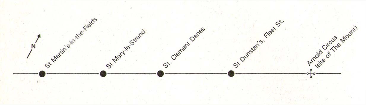
The historian Laurence Gomme (1912) propounded that the ancient stone cross of The Strand nearby, and the Strand maypole, were elements relating to an unbroken line of heathen traditions dating back to the early Saxon period—and the customs here cited would seem to increasingly validate this. A more detailed multidisciplinary analysis of this cluster of sites along The Strand by competent occult historians is long overdue.
The Strand ley (courtesy Paul Devereux)
One final thing: if the position of the Well is indeed the one cited on the 1807 plaque, to the northeast of St. Clement’s church, then it lies bang on the ley-line that was first propounded by Alfred Watkins (1922; 1925; 1927), and subsequently enlarged upon by Devereux & Thompson! (1979)
References:
Devereux, Paul & Thomson, Ian, The Ley Hunter’s Companion, Thames & Hudson: London 1979.
Foord, Alfred Stanley, Springs, Streams and Spas of London: History and Association, T. Fisher Unwin: London 1910.
Gomme, Laurence, The Making of London, Clarendon: Oxford 1912.
Gover, J.E.B., Mawer, Allen & Stenton, F.M., The Place-Names of Middlesex, Cambridge University Press 1942.
Hole, Christina, English Custom and Usage, Batsford: London 1950.
Johnson, Walter, Byways in British Archaeology, Cambridge University Press 1912.
Street, Christopher E., London’s Ley Lines, Earthstars: London 2010.
Sunderland, Septimus, Old London Spas, Baths and Wells, John Bale: London 1915.
Cup-Marked Stone (destroyed): OS Grid Reference – NX 0010 5411
Archaeology & History
Very little is known about this long-lost carving, whose primary information comes from the folklore records. Apparently it was found on a rock a short distance south of the destroyed St. Patrick’s Well and the two sites seem to have had a traditional relationship with each other. The carving had a foot-shaped motif on the rock, and a number of other cup-markings; but I can find no account as to whether the ‘foot’ carving possessed ‘toes’, as seen on the impressive Cochno Stone, north of Glasgow. It may have been little more that the petroglyphic ‘feet’ seen on the recently discovered and aptly-named Footprint Stone, or those on the newly rediscovered Witches Stone; but we cannot discount it being larger, like the Footprint Stone of Dunadd. If we could locate an early sketch of the stone, all would be revealed! Sadly, as E.M.H. M’Kerlie (1916) told us,
“this rock was blasted at the time when the government essayed to make the harbour one of great importance”,
several years after the nearby holy well had been re-routed. Fucking idiots! Any further info on this site would be most welcome.
Folklore
The local story that was told about St. Patrick creating these carvings seems to have been described first of all by Andrew Agnew (1864), who wrote:
“Once, when about to revisit his native land, he crossed the Channel at a stride, leaving the mark of his foot distinctly impressed on one of the rocks of the harbour; unfortunately, in making a new jetty, this interesting memento was destroyed.”
(The mention of the jetty would seem to imply that the carving was closer to the sea than the grid-reference cited above.) In another tale, St. Patrick rested his hand onto the same rock and the marks of his hand and fingers were left there. This folklore motif is found across the world. It relates to cosmological creation myths of indigenous spirits and deities in the tribes and cultures who narrate it. In this instance, the myth of St Patrick replaced a much earlier mythic tale of another giant or deity, whose name we have lost. Unless, of course, such petroglyphs were still being carved in Galloway by local people in the 4th-5th centuries.
A further tale of St Patrick, at Portpatrick, replaced a quite obvious shamanistic tale. When he journeyed back from Ireland to Galloway, Agnew again told us:
“Having preached to an assembly on the borders of Ayrshire, the barbarous people seized him, and, amidst shouts of savage glee, struck his head from his body in Glenapp. The good man submitted meekly to the operation; but no sooner was it over than he picked up his own head, and, passing through the crowd, walked back to Portpatrick, but finding no boat ready to sail he boldly breasted the waves and swam across to the opposite shore, where he safely arrived (according to the unanimous testimony of Irishmen innumerable), holding his head between his teeth!”
Legends such this are found in shamanistic pantheons worldwide. Shamans primary renown is their ability to travel and recover from the Lands of the Dead, always journeying into impossible and inhospitable arenas, with tales of being dismembered, beheaded, dying, and returning to life to help the tribe with whatever it was that required such a task (usually a healing function). This story of St Patrick – and many other saints – are mere glosses onto the earlier animistic stories, then abridged as being better, more spiritually mature, more egocentric. But their roots are essentially animistic.
Royal Commission Ancient & Historical Monuments of Scotland,Inventory of Monuments and Constructions in Galloway – County of Wigtown, HMSO: Edinburgh 1912.
Walker, J. Russel, “‘Holy Wells’ in Scotland,” in Proceedings of the Society of Antiquaries of Scotland, vol.17 (New Series, volume 5), 1883.
")