Maypole (destroyed): OS Grid reference – SD 5161 9212
Archaeology & History
Long since gone, it’s existence was recorded by, amongst others, the Kendal historian Cornelius Nicholson. (1861) He described it in relation to one of the town crosses, that was removed due to it being “an obstruction in the street.” The maypole too, he said,
“was another incumbrance, but indispensable, according to the custom of our forefathers. It stood in Kirkland, opposite the house of the late Thomas Reveley, Esq., and was suffered to remain till within eighty years ago. In the time of our good Queen Katherine, who may fairly be supposed to have partaken of the amusements, countenanced by her royal consort, the original festivity of maying and morris-dancing would be here celebrated, by the annual ceremony of “maying” when, immediately after sunrise, on the 1st of May, processions, entering the town at various inlets, streamed through the streets, with music of horns and flutes; boys with their May-gads (willow-wands twined with cowslips), and girls with their “brats” full of flowers — young and old alike joining in merry laughter, and song, and the customary chorus, “We have brought the summer home.” When the above-named ceremonies became less fashionable, the May Pole was made the rendezvous of all the milkmaids in the neighbourhood, who came and paraded round it on Easter Mondays. On other occasions of rejoicing, afterwards, such for instance, as terminating an apprenticeship, and the like, it became customary for young men to go and dance around it.”
The author then told that this annual village ceremony was still being performed at the beginning of the 19th century, “in the assemblage of young people in the Vicar’s Fields, on Easter Tuesday. After spending the afternoon there, they returned in procession through the streets, threading grandy needles.”
References:
Nicholson, Cornelius, The Annals of Kendal, Whitaker & Co.: London 1861.
Along the A84 road betweeen Callander and Lochearnhead, take the small road west when you reach Balquhidder Station, towards Balquhidder village. Go along here for 1½ miles (2.5km) as if you’re gonna visit the Puidrac Stone; but 200 yards past this, go through the gate on the south-side of the road into the boggy field for about 150 yards towards the River Balvag. You’re looking for several stones, as in the photos. You’ll find ’em. (you may get soaked though!)
Archaeology & History
The stones, looking NW
After many thousands of years, this innocuous-looking group of small stones found in the very boggy field immediately west of the Puidrac Stone looks nothing like it once did. Some modern academics would have you think there was nothing here of prehistoric interest, but oral tradition and earlier writings tell otherwise. Although not shown on the early OS-maps, it was first described in James Gow’s (1887) articulation on the antiquities of the area, in which he told:
“A short distance east from the present (Balquhidder) parish church, in the haugh below the manse, there are seven stones remaining of a circle which appears to have been about 30 feet in diameter; only one stone is in its original upright position, but there are fragments of others lying about; as usual, they are known as “Clachan-Aoraidh,” or worshipping stones, and are not likely to be disturbed during the lease of the present tenant.”
Looking E, with Puidrac Stone just visible left of telegraph post
A few years later when Thomas Ross (1919) visited the area with a Prof Cooper and others, they reported the single standing stone still in position and the anglicized name of the Worshipping Stones was still in evidence amongst locals.
Arc of fallen stones by the trees
Nowadays the site is in ruin. Two of the stones stand out when the rushes aren’t too high, with one earthfast and its companion prostrate; but as you can see in the photo (right), there remains a sunken arc of two other stones laid down, running away from the larger ones, with a fifth overgrown and nearly covered by vegetation and the young trees. In all probability, tradition is probably right here: this is the remains of a stone circle.
Folklore
The field in which these denuded megalithic remains are found, was, wrote Thomas Ross (1919),
“the site of a long-popular market called ‘Feill Aonghais’, i.e., St Angus’ Fair. It was held, according to Mr Campbell, in May; according to Mr Gow, on “the Saint’s Day, the 6th of April.” It was quite the custom…to hold a fair after divine service on the Patronal Feast. The folks came to “kirk and market” on the same day, and mixed good fellowship and manly sport with their worship and their business.”
If you were to hold a fair there nowadays, likelihood is it would get flooded! Christian myths tell of a “St. Angus” taking over whatever the heathen traditions were in this domain, more than a thousand years back.
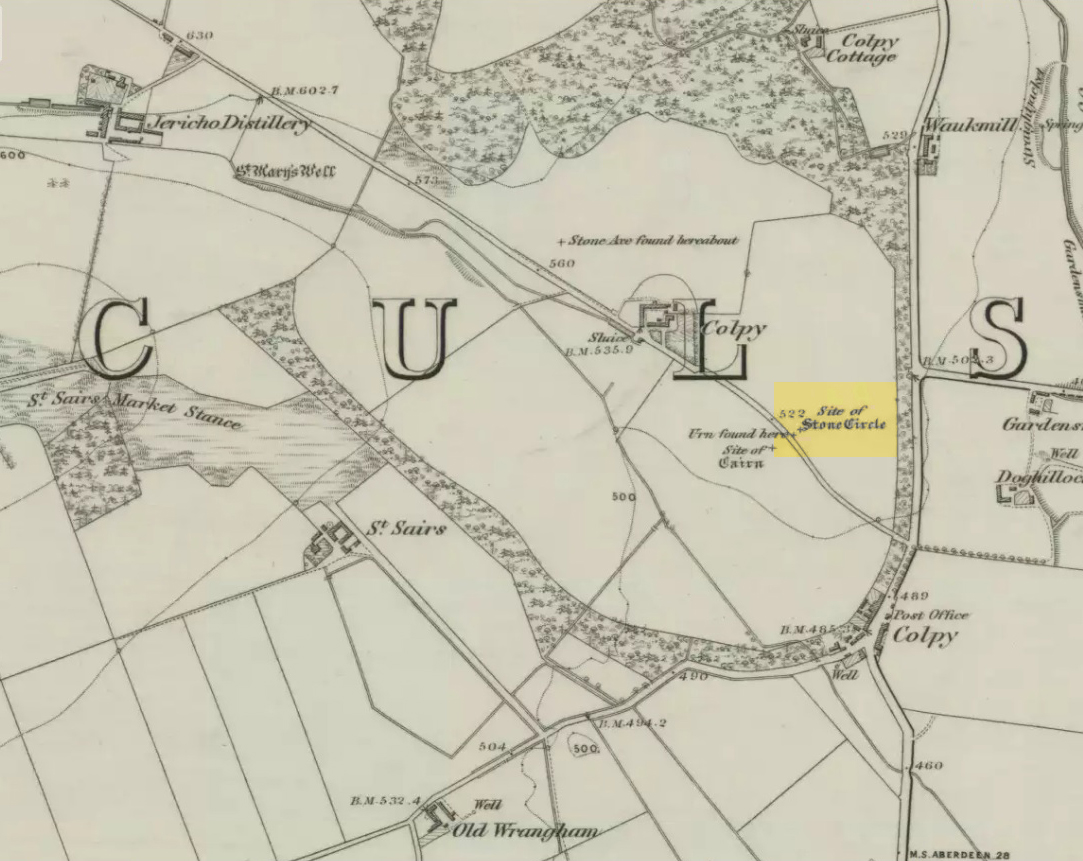
Just like the stone circle a half-mile east at Kirkton of Culsalmond, nothing now remains of this megalithic ring. It was first described very briefly by Rev. F. Ellis (1845) in the New Statistical Account as a “druidical temple”: one of two hereby, “on the farm of Colpie, although now almost obliterated. Several urns were dug up in making a road near one of them”—implying that one of them was a cairn circle or funerary monument of some kind. This was subsequently affirmed on the early OS-map and then described in Fred Coles’ (1902) survey, where he wrote:
“Site of a stone circle, the road going to Jericho Distillery having been made through it, and, on the south side of this road, the site of a cairn. Within the possible diameter of the circle an urn was found.”
Folklore
A few hundred yards west of the circle an ancient fair used to be held, known as St Sair’s Fair, named after St Serf. Although St Serf’s Day is July 1, early records show that the fair—held in a long field with the curious name of ‘St Sairs Market Stance’—was to be held on the Wednesday after the last Tuesday in June. For a stone circle, this is too close to Midsummer to be a coincidence! Early records show that the fair was granted in 1591 and subsequent years thereafter.
St Serf is a very peculiar mythological figure with quite shamanistic traits and tales around him. In truth, many of these early saints were little more than lapsed shamans, utilising natural magick and medicine in the olde traditions, but which became grafted onto the incoming christian mythos. The evidence for this is quite overwhelming!
References:
Barnatt, John, Stone Circles of Britain – volume 2, BAR: Oxford 1989.
Browne, G.F., On Some Antiquities in the Neighbourhood of Dunecht House, Aberdeenshire, Cambridge University Press 1921.
Burl, Aubrey, “The Recumbent Stone Circles of North-East Scotland”, in Proceedings Society of Antiquaries, Scotland, volume 102, 1973.
Burl, Aubrey, The Stone Circles of the British Isles, Yale University Press 1976.
Burl, Aubrey, The Stone Circles of Britain, Ireland and Brittany, Yale University Press 2000.
The second highest of Wiltshire’s prehistoric camps or hillforts, Martinsell Hill was described as early as the 13th century as ‘Mattelsore’ and was known in local dialect and literary forms as variants around the word mattels, until the 16th century, when the title became altered in literature and for the first time became known as ‘Martinshall’ (and variants thereof), which has stuck ever since. As the etymologists Gover, Mawer & Stenton (1939) proclaimed,
“the first element (mattels, PB) must be associated with the old english name for the camp which stands on top of it: the Mætelmesburg of the Pewsey charter” —
A.C. Smith’s old map
Which the authors think derived from “Mætelmesora, i.e., ‘Mæþelhelm’s bank'”, being the name of a tribal leader or elder who gave his name to the hill upon which the fort was built. Margaret Gelling echoes the sentiment in her Place-Names in the Landscape, but we must keep in mind that such derivation is still a quite speculative etymology and one which doesn’t seem to be able to be proven (as yet!).
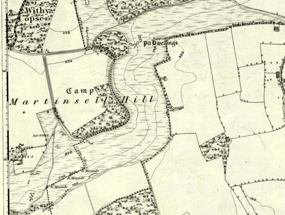
The hillfort and its remains were described in some detail in the second volume of Colt Hoare’s classic Ancient Wiltshire (1819: 107), where he wrote:
“Martin’s Hill or Martinshal Hill is in North Wilts what Long Knoll near Maiden Bradley is in South Wilts, ‘collis longe spectabilis’. This elevated point commands a most advantageous prospect of the rich vale that separates the northern and southern districts of our county, , and is rendered interesting to the antiquary by an extensive earthenwork that crowns the summit of the hill. Its form resembles an oblong square on all sides, except towards the east, where it bends inward in order to humour the natural shape of the hill. Its area, which is in tillage, comprehends thirty-one acres; and as several entrances have been made through the ramparts for the convenience of agriculture, it is difficult to ascertain on which side were the original approaches to the camp. This hill, in its formation, presents a peculiarity rather contrary to the usual system of nature, by rising in height towards the east, where a bold and tremendous precipice of smooth turf shelves down from the summit to the base of the hill. This eminence is more remarkable for the rich and extensive prospect which it affords than for the plan of its entrenchments, which consists of a single vallum and fosse. Not having discovered by digging any certain marks of ancient populations within its area, I am inclined to think that it may be considered as an asylum to which the Britons, who were very numerous in its environs, sent their families and herds in times of danger: the single vallum and ditch prove its British origin, and the great extent of its area seems to warrant this conjecture.”
Hippisley Cox’s ground-plan
This aint a bad assumption for a fella who wrote this 200 years ago without the aid of excavation or modern archaeocentric analysis. But we can see that Hoare was utilizing that dying virtue of common sense here, and find that much of what he said remains the echoed narrative of modern archaeologists who, I believe, still aint done a detailed excavation on the site themselves. (weird for down South!) Later in the 19th century, when the reverend A.C. Smith (1885) visited and wrote about the hillfort, he added little to Hoare’s earlier words. And the descriptive narrative of the site remained roughly the same (Massingham’s intriguing ascriptions aside!) even after a small excavation was undertaken in 1907, which found very little. Hippisley Cox (1927) passed this way in his fine travelogue of ancient roads and trackways in Wessex, describing the enclosed top of this hill as
“the site of a complete neolithic settlement, including dew-ponds, a cattle compound, a flint quarry, lynchetts, dicthes of defence and deep cattle tracks formed by much going and coming of beasts from the valley.”
He may have been right! In more recent times Geoffrey Williams (1993) describes the Martinsell hillfort, which again only gives slightly more info than Colt Hoare’s 1819 narrative. The site covers 32 acres in size, is roughly rectangular in form, measuring roughly 330 yards (302m) across east to west, and 480 yards (439m) north to south. There appears to be at least one entrance on its northeastern edge.
Folklore
What seems to be a survival of prechristian sun lore is found in one or two of the events that used to happen upon and around Martinsell. A number of local history books give varying descriptions of the events here, but Devereux and Thomson (1979) condense the information nicely, telling us that
“The camp seems to have been a focus for curious Palm Sunday ‘games’ in past centuries, one of which involved a line of boys standing at intervals from the base to the summit of the hill. Using hockey sticks, they then proceeded to knock a ball in succession up the hill to the top. Another activity was the throwing of oranges down the hill slopes with boys going headlong after them. Evene more strangely, local youths used to slither down the escarpment on horses skulls.”
Mythographer and writer Michael Dames (1977) thought that such festive activities on and around the hill related to remnants of ancient goddess worship here.
Ley line running from Martinsell (image courtesy Paul Devereux)
In Paul Devereux & Ian Thomson’s (1979) ley hunter’s guide, the Martinsell Hill site stands at the beginning of a ley, which then runs northwest for more than seven miles, eventually ending at the well known causewayed enclosure of Windmill Hill — but not before passing by the Avebury stone circle and several prehistoric tombs on route. This ley is a simple alignment between sites (as the ‘discover’ of leys, Alfred Watkins described them) and has nothing to do with the modern contrivance of energy lines.
…to be continued…
References:
Bradley, A.G., Round about Wiltshire, Methuen: London 1948.
Dames, Michael, The Avebury Cycle, Thames & Hudson: London 1977.
Devereux, Paul & Thomson, Ian, The Ley Hunter’s Companion, Thames & Hudson: London 1979.
Gomme, Alice B., “Folklore Scraps from Several Localities,” in Folklore Journal, 20:1, 1909.
Gover, J.E.B., Mawer, A. & Stenton, F.M., The Place-Names of Wiltshire, Cambridge University Press 1939.
Harding, D.W., The Iron Age in Lowland Britain, RKP: London 1974.
Hoare, Richard Colt, The Ancient History of North Wiltshire, Lackington, Hughes, Mavor & Jones: London 1819.
Massingham, H.J., Downland Man, Jonathan Cape: London 1926.
Partidge, T.B., “Wiltshire Folklore,” in Folklore Journal, 26:2, 1915.
Smith, A.C., A Guide to the British and Roman Antiquities of the North Wiltshire Downs, Wiltshire Archaeological & Natural History Society 1885.
Williams, Geoffrey, The Iron Age Hillforts of England, Horace Books 1993.