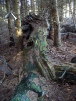
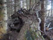
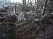
Holy Well, Strathnaver, Farr, Sutherland

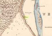
Holy Well (lost):  OS Grid Reference – NC 725 538 (approximation)

Archaeology & History

It would appear that there’s only one literary reference to this seemingly lost holy well, located halfway down megalithic Strathnaver, somewhere close to the legendary Loch ma Naire.  James  Horsburgh’s (1870) essay on the antiquities of this area mentioned it, almost in passing, in his description of the Dun Viden broch.  He told that,

“Close to Dun Viden is Loch Manaar, where dozens of people come twice every year for the cure of diseases.  They come before sunrise, bathe in the loch, walk round it, drink from a holy well (my emphasis), and throw some pieces of money into the loch.  There is a legend about this loch, which I forget; but a woman was chased by a priest, and threw something in it, and called out that it was Loch Manaar—that is, the loch of my shame. “

The holy well is referred to in Historic Scotland’s Canmore entry, citing both the New Statistical Account and Name Books as referrals to the site, yet neither of them include this well in their surveys; it is only through Horbugh that we hear of this site—and we know not where it lived!  In the event that it still exists, we’d expect it to be not more than 2-300 yards from the edge of Loch ma Naire; or perhaps it may be the source of the Loch ma Naire burn itself, nearly a mile to the east….  Seek and thee shalt find, as the old saying goes…

References:

  1. Horsburgh, James, Notes of Cromlechs, Duns, Hut-circles, Chambered Cairns and other Remains, in the County of Sutherland“, in Proceedings Society of Antiquaries, Scotland, volume 7, 1870

© Paul BennettThe Northern Antiquarian


River Barvas, Barvas, Lewis

Sacred River:  OS Grid Reference – NB 351 494

Folklore

As with traditions found all over the world, rivers and lakes had spirits, gods and rituals attached to them.  Despite us believing that no such things ever occurred in Britain and the rest of the so-called ‘civilized’ world, such things were once common.  One of the annual rites performed at the Hebridean river at Barbhas (Barvas)—and described by Alexander Fraser (1878)—is just one such example:

“The natives of Barvas had a peculiar custom on the first day of May, of sending a man across the river at (the) dawn of day to prevent any females from crossing it first, as that would hinder the salmon from ascending the river all the year through.” (Fraser 1878)

The importance of the salmon, both as an important food source and equally as a ‘sacred animal’, is known in myths and legends throughout the British Isles.  To the legendary hero-figure Finn, it played a part of him gaining supernatural wisdom, and this quality is integral to the fish itself who ate the hazelnuts of knowledge and gained such power.  In this same short piece of folklore, the time of year when the ritual should be enacted on the River Barvas is Beltane, which is renowned as the prime period in the annual cycle/calendar relating to fertility.  This element relates to maintaining the fecundity of the river and the salmon where, in this case, men crossing the waters symbolically fertilizes them to ensure the annual return of the fish.  It would be interesting to know when this custom finally died out.

References:

  1. Fraser, Alexander, Northern Folk-lore on Wells and Water, Advertiser Office: Inverness 1878.
  2. Ross, Anne, Pagan Celtic Britain, RKP: London 1967.

© Paul BennettThe Northern Antiquarian

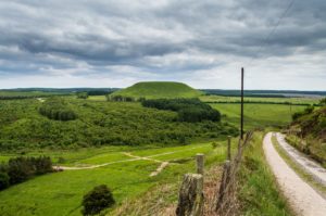
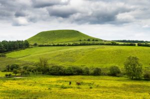
Blakey Topping, Allerston, North Yorkshire

Sacred Hill:  OS Grid Reference – SE 8731 9377

Getting Here

Blakey Topping (James Elkington)

From Pickering, take the A169 towards Whitby. When you get to the Car Park at the ‘Hole-of-Horcum’ – (you can’t miss it), park the car and walk North along the side of the road towards Whitby. After 60 yds, take the track East. Follow this for approximately a mile until the track splits. Take the concrete track left towards the farmhouse of ‘Newgate Foot’. Go through the yard past the house on the right, and you will come to a stream and a gate and there, ahead of you, rises Blakey Topping…

Archaeology & History

The giant hill of Blakey Topping was recorded as early as 1233 CE and in a simplistic style just means the ‘black mound’; but this derivation has additional ingredients, implying it as a ‘black meeting-place’ or moot.  Black in the etymological sense also implies ‘shining’ and it may also relate to the northern airt of black (meaning death, darkness, north, etc), when you’re stood at the ruined stone circle 400 yards to the south. But I’m speculating here…

Several 19th century antiquarians suggested there may have once been a cairn on top of the hill, but others who’ve explored this idea seem to have put it to bed.

Folklore

This great hill is well recognised amongst local people and, to this day, its animistic creation myths and other folklore elements are still spoken.  When the photographer James Elkington recently visited the nearby standing stones, he bumped into the old farmer who told him how his father had seen the faerie-folk on the hill many years back.  And its modern reputation as a gorgeous site adds to such lore, which dates way back.

In Frank & Harriett Elgee’s (1933) archaeology work, they narrated the old creation myth that local people used to tell of this great hill,

“A witch story related by a native 25 years ago attempts to explain two conspicuous natural features two miles apart on Pickering Moor; Blakey Topping, an isolated hill, and the Hole of Horcum, a deep basin-shaped valley. The local witch had sold her soul to the devil on the usual terms, but when he claimed it, she refused to give it up, and flew over the moors, with the devil in hot pursuit. Overtake her he could not, so he grabbed up a handful of earth and flung it at her. he missed his aim and she escaped.  The Hole of Horcum remains to prove where he tore up the earth and Blakey Topping where it fell to the ground.

“From our point of view the significance of this story lies in the fact that between the Hole and the Topping there is a Bronze Age settlement site at Blakey Farm, with its stone circle. The rough trackway leading from the Hole to the circle is known as the Old Wife’s Way, presumably also marking the witch’s flight. This, together with other Old Wife’s Ways, preserves as it were Bronze Age church tracks”.

Looking up from the SW (James Elkington)

A relative variation on this tells that the Hole of Horcum was made by the local giant, Wade. He was having a row with his wife, Bell, and got so angry that he scooped out a lump of earth and threw it at her.  The huge geological feature known as the Hole of Horcum is the dip left where he scooped out the earth, and Blakey topping, the clod itself, resting in situ where it landed.  A christian appropriation of the story replaces Wade and his wife with their ‘devil’: a puerile element unworthy of serious consideration.

In more recent times, the old geomancer Guy Ragland Phillips (1976; 1985) found that a number of alignments, or leys (known as a ‘node’), centred on Blakey Topping: twelve in all, reaching out and crossing numerous holy wells, prehistoric tumuli, standing stones, etc.  The precision of the alignments is questionable, yet the matter of the hill being a centre-point, or omphalos, would seem moreso than not.

References:

  1. Elgee, F. & H.W., The Archaeology of Yorkshire, Methuen: London 1933.
  2. Phillips, Guy Ragland, Brigantia, RKP: London 1976.
  3. Phillips, Guy Ragland, The Unpolluted God, Northern Lights: Pocklington 1987.
  4. Smith, A.H., The Place-Names of the North Riding of Yorkshire, Cambridge University Press 1928.

Links:

  1. Mountains, Myths and Moorlands

Acknowledgements:  Big thanks to the photographer, James Elkington, for use of his photos in this profile. Cheers mate.

© Paul Bennett & James ElkingtonThe Northern Antiquarian


Wife with the Bratty Plaid, Balfron, Stirlingshire

Standing Stone:  OS Grid Reference – NS 60027 91383

Getting Here

The Wife with the Bratty Plaid

The Wife with the Bratty Plaid

Take the same route as if you’re visiting the small Carlin Stone (a few hundred yards further along): along the B822 road between Kippen and Fintry, stop at Balafark farm and cross the road above the farm to take the track into the forest.  1km along, note the small green track, off the main central track, slightly up on the rise on your right, which bends round and then goes (eventually) to the other side of the forest.  Once you reach the gate at its edge, walk left 285 yards (261m) along the fence.

Archaeology & History

The Wife and the Carlin on the 1865 OS-map

The Wife and the Carlin on the 1865 OS-map

Described in the Ordnance Survey’s (1870) Book of Reference (volume 47) as “a flat rock on the boundary between Perth and Stirling,” the rock is certainly not flat—and any geographical relationship it had with Perth has long since gone.  Instead, the stone in question here is an upright one—although it’s not much more than two feet tall.  However, on the other side of the present-day fence there is a small flat stone in the ground; but it is the moss-covered upright that is our ‘Wife with the Bratty Plaid.’  A smaller curious-looking quartz-lined stone also lies next to this old Wife…

The Wife, looking east

The Wife, looking east

The Wife, looking west

The Wife, looking west

Marked on the ancient boundary line, this small but sturdy standing stone probably has a prehistoric pedigree, although we cannot be certain without an excavation.  It is shown on the earliest OS-maps from the 1860s, but we have no notifications from any literary sources telling the tale behind the stone’s fascinating name: meaning simply, the ‘wife wearing the tartan shawl.’  When Marion Woolley and I came here the other day, we tried to see if a simulacrum of such a figure was hiding in the moss-covered upright—but unlike the notable simulacrum at MacBeth’s Stone, we struggled somewhat here.  It was possible, from certain angles (if we didn’t stand on our heads and poke each other in the eyes!) to see this ‘wife in a shawl’, but twas a struggle…

There’s every likelihood that whatever the old tale once was about this petrified ancestral stone, it would have had some mythic relationship with the Old Wife known as the Carlin, or cailleach, a few hundred yards to the west, at the Carlin Stone.  As yet however, their histories remain hidden in the sleep of the Earth…

Links: 

  1. Nataraja’s Foot – The Wife with the Bratty Plaid

Acknowledgements:  Huge thanks to Marion Grace Woolley, for a truly soggy day out and for the photos in this site profile.

© Paul BennettThe Northern Antiquarian


Carlin Stone, Balfron, Stirlingshire

Legendary Stone:  OS Grid Reference – NS 59553 91277

Getting Here

Carling Stone on 1866 map

Carling Stone on 1866 map

Take the B822 road between Kippen and Fintry, stopping at Balafark farm.  On the other side of the road, above the farm, take the track into the forest.  Naathen…. 1120 yards (1.02km) along, note the small green track, off the main central track, slightly up on the rise on your right. It bends round and then goes (eventually) straight to the edge of the forest.  Once you reach the edge, go left all along the fence until it meets the large gate 800 yards WSW.  20 yards past the gate, a small stone is along the fence-line. This is the Carlin!

Archaeology & History

Carling Stone, looking east

Carling Stone, looking east

Found along the same boundary line as another stone with similar mythic virtues (called the ‘Wife with the Bratty Plaid’), when Marion Grace Woolley and I visited the site earlier, we found only a small upright, barely a foot tall, right in line with the ancient boundary along a newly made fence.  Thankfully, whoever built the fence, understood the nature of the stone, and left it in the ground where it belongs.  We know not for sure exactly how old this stone might be, but it its name and position suggest very old – probably prehistoric.

The Carlin is another word for the Cailleach: the prima mater or great Earth goddess in Irish, Scottish and northern English animistic traditions.  Her virtues are immense, representing the cycles of the natural world, a creation giant, healer and a whole host of other elements inherent to the natural world.  Although She tends to be represented as the Winter hag, the Cailleach changes Her faces and attributes as the cloaks of the seasons go by, annually, cyclically, year after year after year.  She’s as much the cloak of the Winter as She is the fertility of Spring, the warmth of the Summer and the fruits of Autumn.

Carling Stone, looking west

Carling Stone, looking west

Whatever traditions there might have been at this small Carlin Stone are now long forgotten it seems.  We find no bodach (Her husband) in immediate attendance.  However, the existence of the small standing stone called the ‘Wife with the Bratty Plaid,’ several hundred yards to the east along the same ancient boundary line, implies there would have been a traditional perambulation along this boundary, and during such annual ritual walks, tales or words may have been said here.  Does anyone know more…?

© Paul BennettThe Northern Antiquarian


Witch Tree, Aberuthven, Perthshire

Sacred Tree:  OS Grid Reference – NN 9621 1587

Getting Here

Witch Tree on 1901 OS-map

Witch Tree on 1901 OS-map

Just off the A9 between Stirling and Perth is Aberuthven village.  Down the Main Street and just south of the village, turn west along Mennieburn Road.  A half-mile on, just past Ballielands farm, you reach the woods.  Keep along the road for another half-mile, close to where the trees end and go through the gate where all the rocks are piled. Walk up to the tree-line 50 yards away and follow it along the line of the fence east, til it turns down the slope.  Naathen – over the barbed fence here, close to the corner, about 10 yards in, is the tree in question…

Archaeology & History

Witch Tree03

Looking along the fallen trunk

Laid down on the peaty earth, fallen perhaps fifty years ago or more, are the dying remains of this all-but forgotten Witch Tree.  To those of you who may strive to locate it—amidst the dense eye-poking branches of the surrounding Pinus monoculture—the curious feature on this dying tree are a number of old iron steps or pegs, from just above the large upturned roots.  About a dozen of them were hammered into the trunk some 100 years or more ago and, were it to stand upright again, reach perhaps 30 feet high or more.  These iron pegs give the impression of them being used to help someone climb the tree when it was upright; but their position on the trunk and the small distance between some of them shows that this was not their intention.  Their purpose on the tree is a puzzle to us (does anyone have any ideas?).

Embedded pieces or iron from roots...

Embedded iron from the roots

Embedded iron 30-40ft along

Embedded iron 30-40ft along

The fallen trunk has broken into two main sections, each with iron pegs in them.  The very top of the tree has almost completely been eaten back into the Earth.  Unfortunately too, all the bark has completely rotted away and so identifying the species of the tree is difficult (though I’m sure there are some hardcore botanists out there who’d be able to enlighten us).  The possibility that the early map-reference related to a Wych-elm (Ulmus glabra) cannot be discounted, although this would be most unusual for Ordnance officers to mistake such a tree species with a ‘witch’.  Local dialect, of course, may have been a contributing factor; but in Wilson’s (1915) detailed analysis of the regional dialect of this very area, “wych elm” for witches does not occur.  Added to this is the fact that the indigenous woodland that remains here is an almost glowing birchwood (Betula pendula) in which profusions of the shaman’s plant, Amanita muscaria, exceed.  There were no wych elms hereby.

The tree was noted by the Ordnance Survey team in 1899 and was published on their maps two years later, but we know nothing more about it.  Hence, we publish it here in the hope that someone might be able top throw some light on this historical site.

Folklore

Looking along the fallen trunk

Halfway along the fallen tree

We can find nothing specific to the tree; but all around the area there are a plethora of tales relating to witches (Hunter 1896; Reid 1899)—some with supposedly ‘factual’ written accounts (though much of them are make-believe projections of a very corrupt Church), whilst others are oral traditions with more realistic tendencies as they are rich in animistic content. One of them talks of the great mythical witch called Kate McNiven, generally of Monzie, nearly 8 miles northwest of here.  She came to possess a magickal ring which ended up being handed to the owners of Aberuthven House, not far from the Witch Tree, as their associates had tried to save her from the crazies in the Church.  This may have been one of the places where she and other witches met in bygone centuries, to avoid the psychiatric prying eyes of christendom.

Until the emergence of the Industrialists, trees possessed a truly fascinating and important history, integral to that of humans: not as ‘commodities’ in the modern depersonalized religion of Economics, but (amongst other things) as moot points—gathering places where tribal meetings, council meetings and courts were held. (Gomme 1880)  The practice occurred all over the world and trees were understood as living creatures, sacred and an integral part of society.  The Witch Tree of Aberuthven may have been just such a site—where the local farmers, peasants, wise women and village people held their traditional gatherings and rites.  It is now all but gone…

References:

  1. Gomme, Laurence, Primitive Folk-Moots, Sampson Lowe: London 1880.
  2. Hunter, John, Chronicles of Strathearn, David Philips: Crieff 1896.
  3. Reid, Alexander George, The Annals of Auchterarder and Memorials of Strathearn, Davdi Philips: Crieff 1899.
  4. Wilson, James, Lowland Scotch as Spoken in the Lower Strathearn District of Scotland, Oxford University Press 1915.

© Paul BennettThe Northern Antiquarian


Beltane Well, Kenmore, Perthshire

Sacred Well:  OS Grid Reference – NN 7867 4725

Also Known as:

  1. An Tobar
  2. Holy Well of Inchadney

Getting Here

An Tobar, or Beltane Well, on the 1867 map

An Tobar, or Beltane Well, on the 1867 map

From Kenmore village on the north-side of the river, over the bridge, take the small road on your right towards Dull.  After a very short distance the road runs alongside the woodland for nearly 1½ miles until, on your left, you’ll reach Drummond Cottage.  Across from here a dirt-track takes you into the trees.  Barely 100 yards along, watch for the overgrown path that runs down the slope on your left.  At the bottom a small stream has several feeds – one of which is surrounded by a ring of bright quartz stones.

Archaeology & History

Shown on the early Ordnance Survey maps as An Tobar (meaing simply “a well”), this somewhat nondescript title betrays a much more colourful folk history, albeit dissolved by those common culprits of Church and disrespectful incomers (which shows little sign of diminishing).

Lara by the Well

Lara by the Well

Close-up of quartz surround

Close-up of quartz surround

In the field immediately south, back up the slope above the well and through the trees, was once an ancient church whose existence has all but vanished.  Hereby was held an ancient fair known as Feill nam Bann Naohm, or the Fair of the Holy Women, named after a group of nuns whose lived here, who William Gillies (1938) and others proclaim were the legendary Nine Maidens, whose dedications at wells, trees and other sites scatter Scotland. But the fair was ended in 1575 and moved to Kenmore; then, several years later in 1579, the church also moved onto Eilean nam Ban Naomh (NN 7664 4536) on Loch Tay.

The old well however, after being left by the descendants of the Holy Women or Nine Maidens, continued to be frequented by local people.  Gillies (1938) wrote:

“The Holy Well of Inchadney is situated at the foot of the terrace, about five hundred yards to the north of the churchyard… Up to the middle of last century the well used to be visited by great numbers of people on the morning of Bealtuinn, the first day of May.”

In Ruth & Frank Morris’ survey (1981) they told how the site had become much overgrown and,

“The well was cleaned out in 1914 and among articles found was a stone 21 inches by 16 inches, with a rude St Andrew’s cross scratched on it, a George III farthing among other copper coins, a rudely made stone cup 2½ inches high and 7 inches in diameter, three metal buttons, a glass bead and six pins.”

No such offerings seemed in evidence when we visited a few weeks ago; but we were told that people are still seen visiting the well.
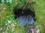
Looking down into the pure waters

Looking into the pure waters

A small stone-laid footpath runs towards the adjacent burn from the circular well, which is almost completely surrounded by large quartz rocks.  In the well itself was a small fish, showing how clean the waters are—or as would be deemed in times of olde: a ‘guardian’ of the waters.

We must also make note of the fact that, just two fields away to the north, according to the antiquarian Fred Coles (1910), a stone circle was once in evidence.  This old well sat neatly between the sites of megalithic ring and church.

Folklore

In the field in front of the well, Hilary Wheather (1982) told that there once lived a legendary water bull, but she lamented on his passing.  With the coming of the modern-folks and their unnatural ways,

“and having great timber lorries rumbling past your home every day is no fun for a peace-loving waterbull living in Poll Tairbh, the Bull’s Pool opposite the Holy Well.  Gone are the days when he was the revered Spirit of the Meadow, passed with trembling and fear by all the young maids of the Parish lest he should jump out and carry them off to his watery lair. Half the calves of the area were sired by him and it was always easily seen which cow had the attentions of the Great Waterbull.  Her calf was always the biggest and the best.  But he hasn’t been seen by his pool for many a year…”

The waters are cited by Geoff Holder (2006) to be good for toothache.

References:

  1. Coles, Fred, “Report on Stone Circles Surveyed in Perthshire (Aberfeldy District),” in Proceedings of the Society of Antiquaries, Scotland, volume 44, 1910.
  2. Gillies, William A., In Famed Breadalbane, Munro Press: Perth 1938.
  3. Holder, Geoff, The Guide to Mysterious Perthshire, History Press 2006.
  4. McHardy, Stuart, The Quest for the Nine Maidens, Luath Press: Edinburgh 2003.
  5. Miller, Joyce, Magic and Witchcraft in Scotland, Goblinshead: Musselburgh 2010.
  6. Morris, Ruth & Frank, Scottish Healing Wells, Alethea: Sandy 1982.
  7. Wheater, Hilary, Kenmore and Loch Tay, Appin Publications: Aberfeldy 1982.

Acknowledgements:  Big thanks to the bunch who got us here:  to Paul Hornby, Nina Harris, Aisha Domleo & Lara Domleo (ooh – and Leo too!).

© Paul BennettThe Northern Antiquarian


Kipps, Linlithgow, West Lothian

Stone Circle (destroyed):  OS Grid Reference – NS 9909 7387

Also Known as:

  1. Canmore ID 47920

Archaeology & History

Site shown on 1856 map

In an Address to the Scottish Society of Antiquaries in the middle of the 19th century, Sir James Simpson (1862) pointed out the outright destruction and vandalism that incoming land-owners (english mainly, and probably christians too) had inflicted on the monuments of the Scottish people.  Stone circles and two cromlechs, he said, that had existed in this part of West Lothian for thousands of years, were recently destroyed when Simpson was alive.  One of them was here at Kipps.  He told:

“In 1813 the cromlech at Kipps was seen by Sir John Dalzell, still standing upright.  In describing it, in the beginning of the last century, Sir Bobert Sibbald states that near this Kipps cromlech was a circle of stones, with a large stone or two in the middle; and he adds, “many such may be seen all over the country.”  They have all disappeared; and latterly the stones of the Kipps circle have been themselves removed and broken up, to build, apparently, some neighbouring field-walls, though there was abundance of stones in the vicinity equally well suited for the purpose.”

Simpson suggested, quite rightly, that efforts should be made to resurrect the old monument.  In his day the fallen remnants of the ‘cromlech’ that had stood inside the circle were still in evidence and it was highlighted on the early OS-map of the region; and when the northern antiquarian Ratcliffe Barnett (1925) came walking here earlier in the 20th century he told he could still see “the remains of an ancient cromlech, which stood within a circle of stones.”  Around the same time, the Royal Commission (1929) lads looked for these remains but seemed to have gone to the wrong site, “a quarter-mile northwest of Kipps Farm”, where they nevertheless found,

“a tumbled mass of boulders containing about thirty stones, one being erect; they vary from 6 by 3 by 1½ feet by 4 by 3 by 2½ feet, and are probably the remains of a cairn.”

When the renowned chambered tomb explorer Audrey Henshall (1972) followed up the directions of the Royal Commission, she was sceptical of giving any prehistoric provenance to the rocks there, describing them simply as geological “erratics.”

The very place-names Kipps may derive from the monument, for as Angus MacDonald (1941) told, “the word seems to come from Gaelic caep, ‘a block’”, but the word can also mean “a sharp-pointing hill, a jutting point, or crag on a hill”, and as the house and castle at Kipps is on an outlying spur, this could be its meaning.

Folklore

Local lore told how lads and lassies would use the stones as a site to promise matrimony with each other, by clasping their hands through a gap on the top boulder.  Using holes in or between stones to make matrimonial bonds, where the stone is the witness to the ceremony, occurs at many other sites and became outlawed by the incoming christian cult, which took people away from the spirits of rock, waters and land.

References:

  1. Barnett T. Ratcliffe, Border By-Ways & Lothian Lore, John Grant: Edinburgh 1925.
  2. Duns, J., “Notes on a Burial Mound at Torphichen, and an Urn found near the ‘Cromlech’ at Kipps, Linlithgowshire”,  in Proceedings of the Society of Antiquaries, Scotland, volume 12, 1878.
  3. Henshall, Audrey S., The Chambered Tombs of Scotland – volume 2, Edinburgh University Press 1972.
  4. Lewis, A.L., “The Stone Circles of Scotland,” in Journal Anthropological Society Great Britain, volume 30, 1900.
  5. MacDonald, Angus, The Place-Names of West Lothian, Oliver & Boyd: Edinburgh 1941.
  6. Royal Commission on the Ancient & Historical Monuments, Scotland, Midlothian and Westlothian, HMSO: Edinburgh 1929.
  7. Simpson, James Y., “Address on Archaeology,” in Proceedings Society of Antiquaries, Scotland, volume 4, 1862.

Acknowledgements:  Accreditation of early OS-map usage, reproduced with the permission of the National Library of Scotland.

© Paul BennettThe Northern Antiquarian


Weeping Stone, Fladaigh Chuain, Skye

Legendary Rock: OS Grid Reference – NG 3638 8091

Getting Here

Unless you’ve got your own boat, forget it!  This one’s miles out on the isolated uninhabited island of Fladda-chuain about 5 miles off the northwest tip from Duntulm, Trotternish.  I wouldn’t mind a coupla weeks alone on the isle though – if anyone can get me there!

Archaeology & History

This little rocky island was allegedly another one of the many visiting places that St. Columba frequented in his copious ventures, trying to sell his new religion to local people wherever he went.  Here he came to the legendary clach known as the Weeping Stone: a place of reverence to the druids and indigenous people.  But St Columba came here to christianize the rituals that were had at the site; and, eventually, he was allowed to build a  small stone chapel close by.

Folklore

In Otta Swire’s (1961) excellent work on the folklore and history of the Isle of Skye, she wrote:

“In Duntulm Bay lies Tulm Island and beyond it, in clear weather, Fladdachuan, Fladda of the Ocean, can be seen. In olden times this was a sacred spot, held by many to be Tir-nan-Og, the Isle of Perpetual Youth, which lay in the west; here it is always summer and the sun never sets. The puffins recognized its sacred nature and never began any venture until they had circled the island three times sunwise; this they did also on arriving in Skye and before leaving it. It was held by some to be the reason why in Skye people used to turn three times sunwise before starting a new enterprise. The Druids held it in veneration and St. Columba caused a chapel to be built there. On its altar lay a black stone which some say was the original altar stone of the Druids and which was known as the Weeping Stone because it was always wet. Until fairly recently fishermen used to land on the island and pour three handfuls of seawater on the stone to procure favourable winds or to stop bad floods. The Weeping Stone no longer exists, or at least is no longer to be found where the altar once stood.”

I can’t find anything more about this place.  Does anyone know owt more about it?

References:

  1. Swire, Otta F., Skye: The Island and its Legends, Blackie & Son: Glasgow 1961.

© Paul BennettThe Northern Antiquarian


Beinn na Caillich cairn, Broadford, Skye

Chambered Cairn:  OS Grid Reference – NG 6291 2377

Getting Here

Henshall’s plan of Beinn na Caillich tomb

From Broadford town, head northwest outta town up the A87 for a mile, turning left and stopping by the electricity station just 100 yards along.  Follow the line of cables down, SE, through the trees, dead straight for about 600 yards (crossing the large stream about halfway) till you notice an open gap through the trees on your right where, 40 yards in, there’s a large circular arena which has been kept aside amidst which a scattered mound is clearly visible.  In this opening in the trees…this is where the tomb/s rest…

Archaeology & History

Sited a mile east on lowlands beneath the shadow of Beinn na Cailleach mountain, with its host of heathen legends and lore, is reputed to be the prehistoric remains of an important ancestral burial site, under dominion of the cailleach’s eye.  In Audrey Henshall’s (1972-2) magnum opus she describes the remains of what may be two separate tombs here as “difficult to interpret”; even “questioning whether they do in fact represent the ruins of a chambered cairn” as has been ascribed.  The site is still included in the Canmore survey, where they cite the same reference as I do here, but add no additional data to Henshall’s query.  There is obviously something to be seen here, but until excavation of the site has been done, the exact nature of what lies here cannot be clarified.  Miss Henshall wrote:

“There is a setting of stones forming about a third of the west side of a circle which would have a diameter of about 30ft if complete; its greatest N to S measurement is 23ft. The stones are thin slabs 4 to 5in thick, up to 3ft 6in long, set on their long sides and projecting up to 2ft above the turf.  The stones have probably been reduced in size due to natural fracturing as the stone readily flakes away. Within this setting, which might be interpreted as the kerb of a cairn, there is a rise of about 1ft above ground level and the grass grows greener, but except for this and a number of boulders lying about the site, there is no sign of cairn material. This is curious as there is no obvious reason for removing it.

“Inside the ‘kerb’ there is a horse-shoe setting of five similar slabs, just visible except for two on the S side which project 1ft 2in due to some peat on their N side having been removed. The enclosed area is 7ft wide by 7ft 6in long, open on the E end.  On this side, 14ft from the W end of the setting, is a larger stone, set on end, 2ft 8in high.  This might be regarded as a portal stone except that it is set opposite the centre of the open end of the horse-shoe setting, and there is a low thin slab projecting westwards from the middle of its W face.  E of this there lie a number of flat slabs and boulders, the larger (some measuring 3ft 8in by 3ft and 4 by 2ft) marked on the plan, but they do not suggest the form of the original structure.

“A stone is set radially to the kerb, 15ft 8in to the N.  It is on its long edge, 4ft 11in long and 2ft 2in high.  Twenty eight feet S of the kerb there is a circular setting of small boulders, 6ft 6in across inside, and part of another concentric setting can be traced 6ft outside these.”

References:

  1. Henshall, Audrey, The Chambered Tombs of Scotland – volume 2, Edinburgh University Press 1972.

© Paul BennettThe Northern Antiquarian