From Pitlochry town centre, walk down the A924 high street as if you’re going to the Blair Atholl Distillery, but just before it take the right-turn and go over the river, and just keeping walking along this road for a third-of-a-mile (0.5km) until your reach a small small on your left that swerves up the hill (there’s a little signpost here saying Cluny Path to Strathtay). Go up and across the main road, then just keeping walking up the dirt-track, which becomes a footpath, and heads further uphill into and through the woodland. Make a bittova daydream from the walk up here, making sure to keep to the path closest to the burn (stream) on your left. Eventually when it levels out, you’re very close. Just keep on the same track and, where it meets up with another, bear left and about 100 yards along, on a small rise in the trees on your right, you’ll see these old stones peeking out. Keep your wits about you!
Archaeology & History
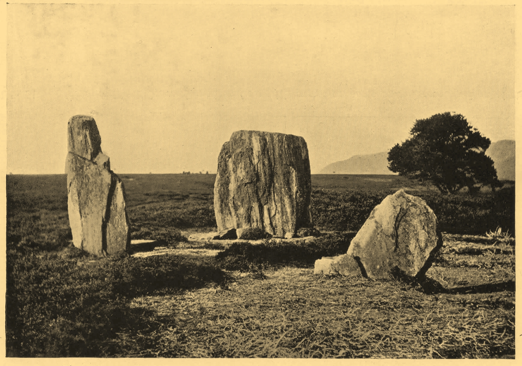
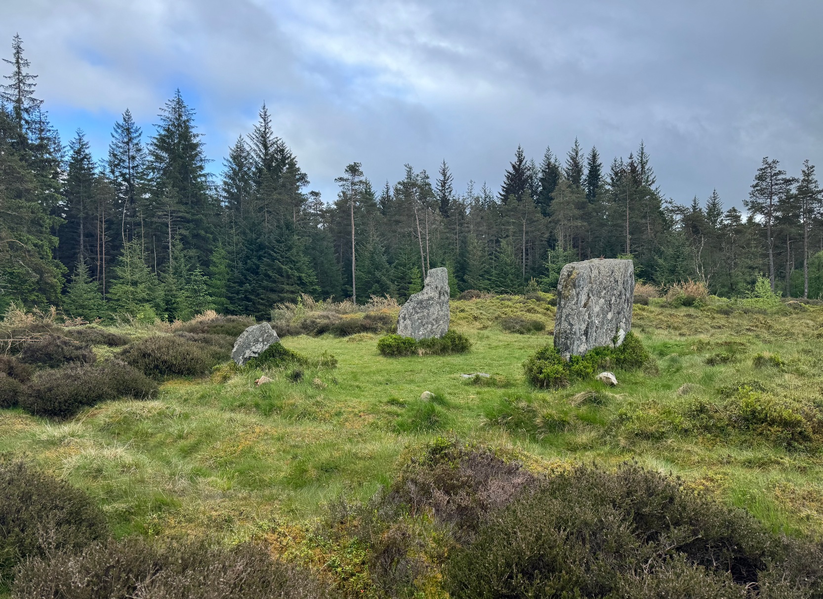
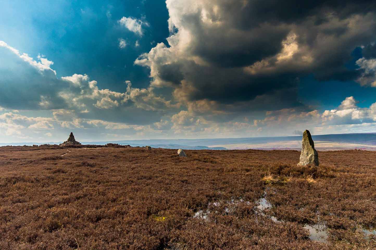
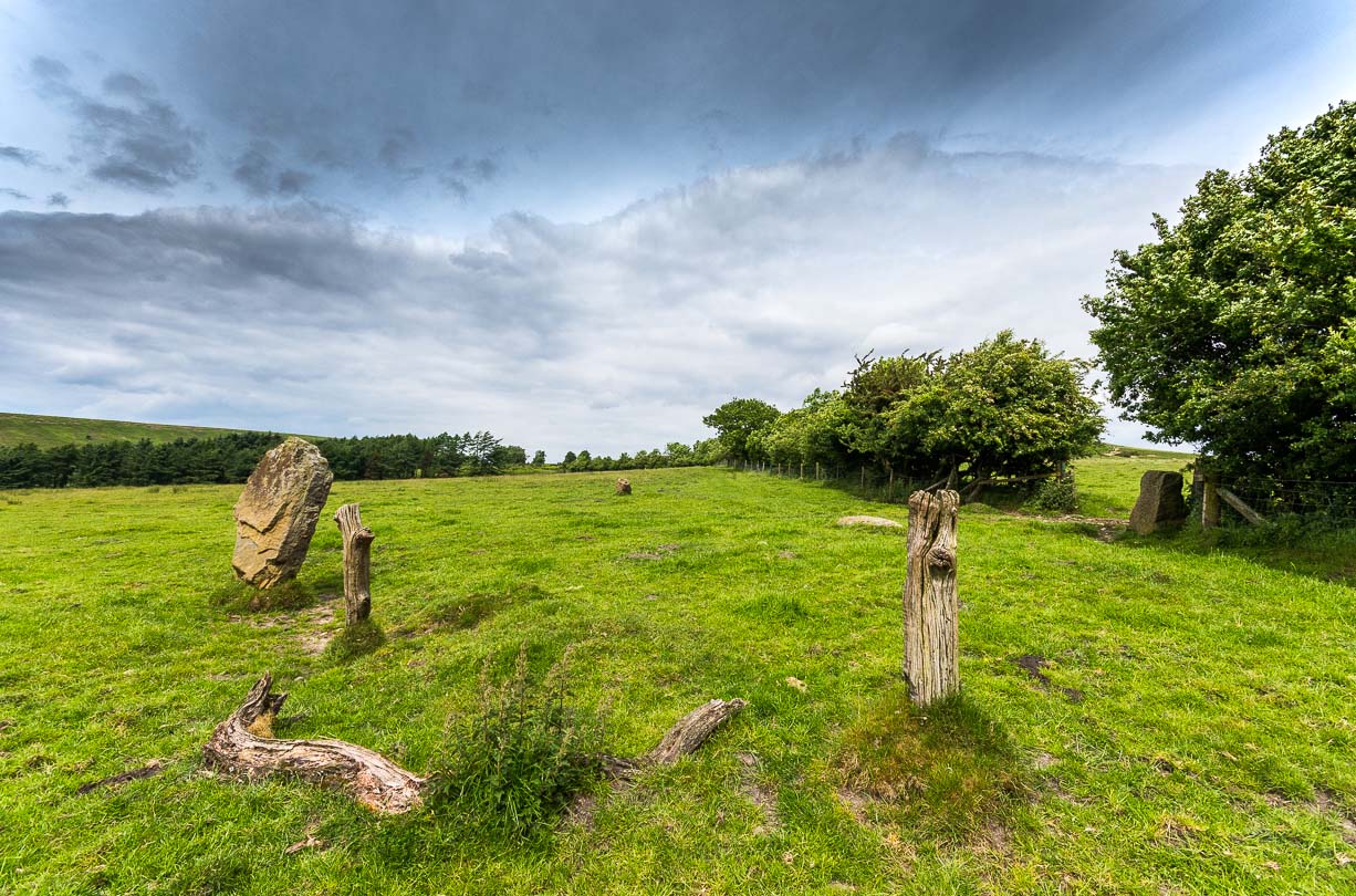
Clachan an Diridh looking E
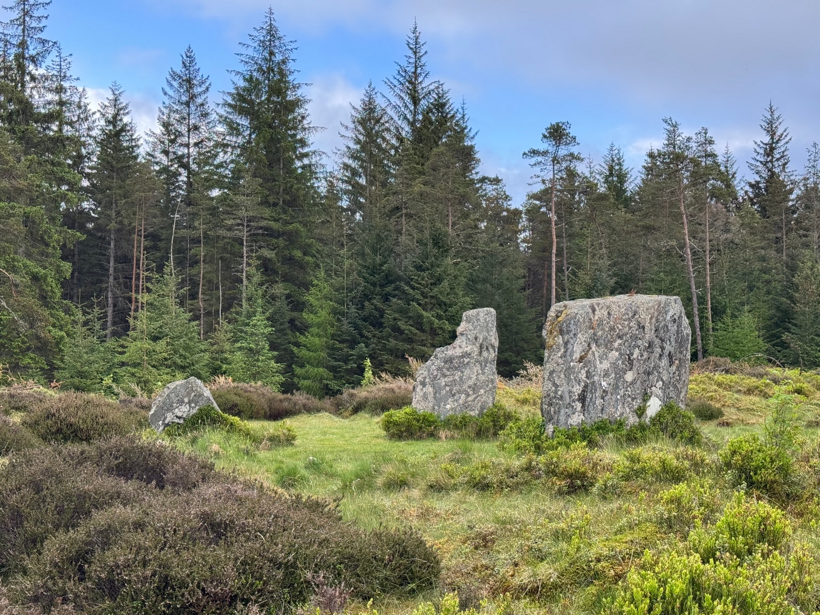
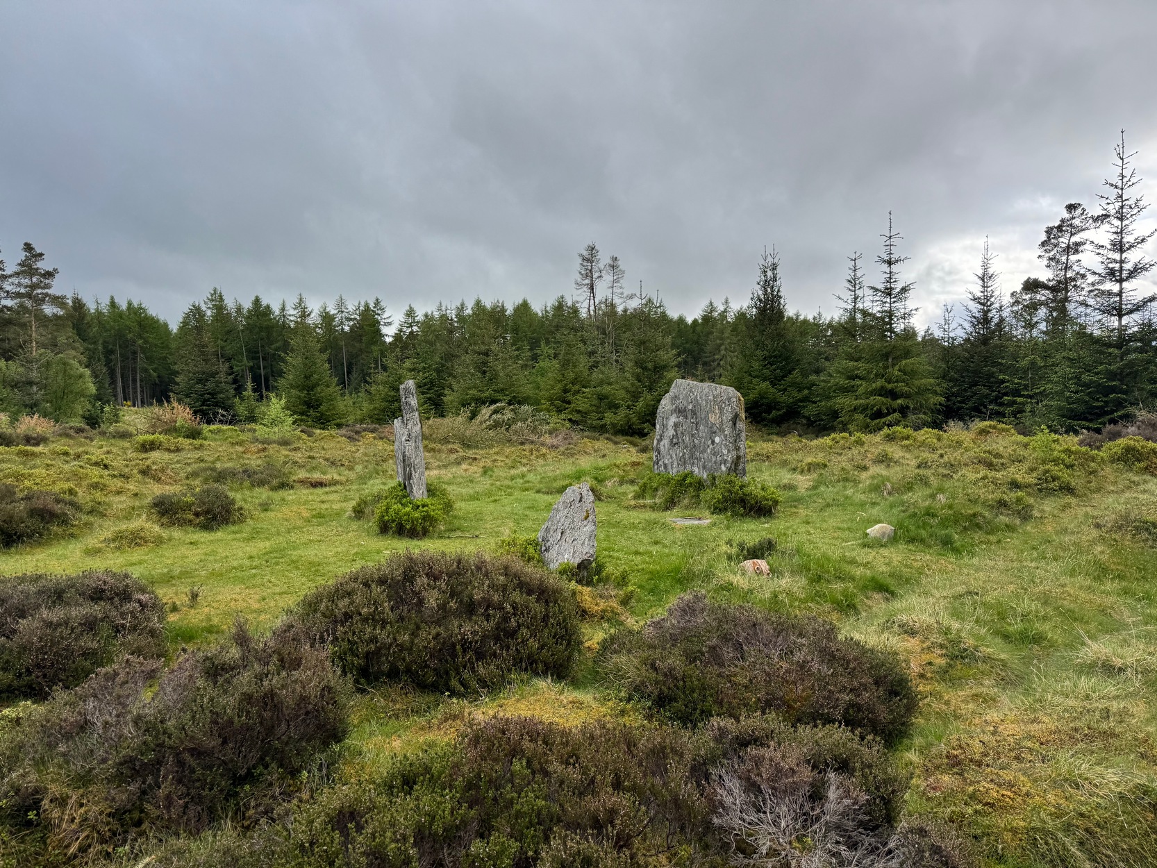
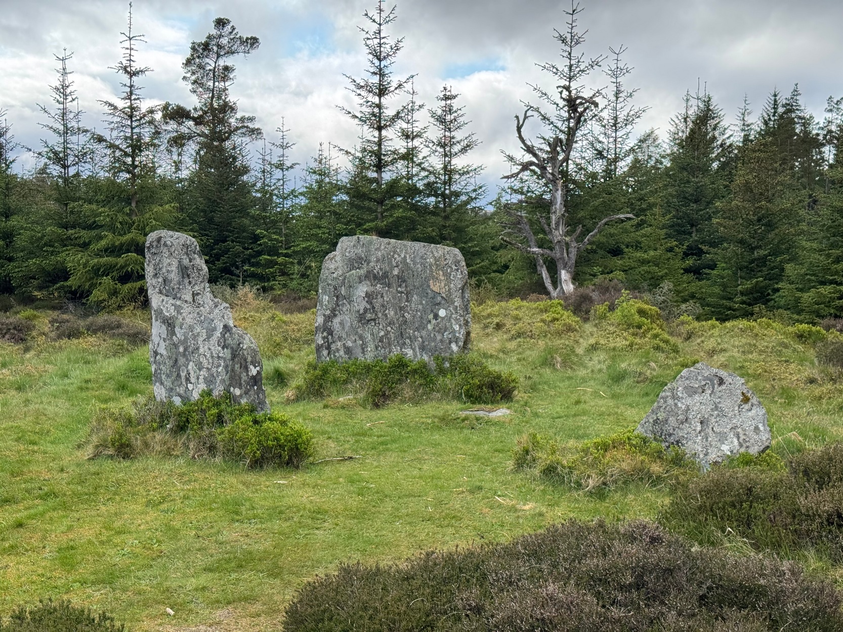
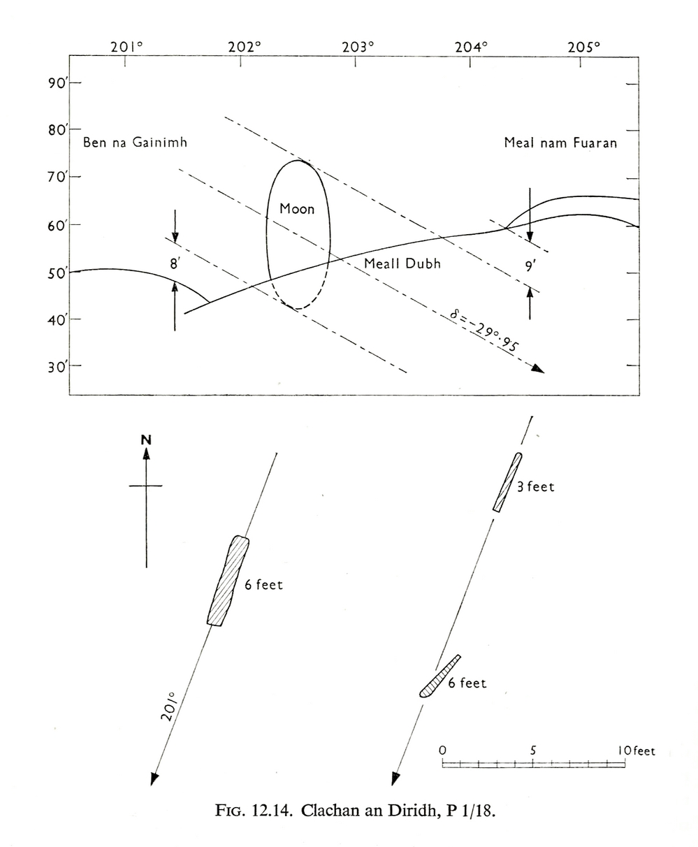
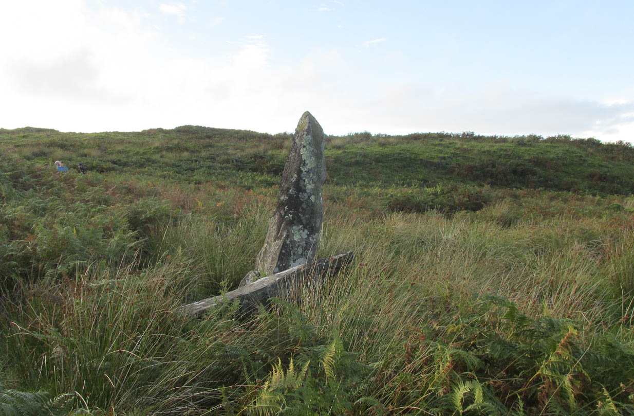
Sat high up on open moorlands with views all round… is what this site used to look like. Sadly, the forestry commission have almost completely enclosed this prehistoric site, making any view of the surrounding landscape all but impossible. I’m not the first and won’t be the last person to be pissed-off by such thoughtlessness. Alexander Thom made mention of it too. After making an initial assessment of the astronomical alignments at these stones in 1967, “when we returned to measure the horizon we found that trees had been planted round the stones and so we failed.” (Thom 1990) Not good.
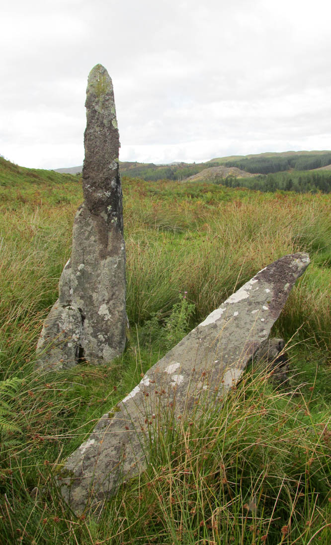
On my first visit here, as I entered this “stone circle” my first impression was that it wasn’t a circle at all, but the remnants of a megalithic stone row! Thom thought the same. It’s the slender thin stature of the stones that do it to you: they almost cut the air and point the enquiring nose dead straight along the same angle that all the stones have been deliberately aligned to. I assume they’ve had a similar effect on other people over the years.
The Clachan an Diridh, or the Stones on the Ascent, were first mentioned in Dan Wilson’s (1851) major survey and who was so impressed by the view from here and its setting in the landscape that he compared its visage to Stonehenge. Were it not for the short-sightedness of the Forestry Commission destroying the view, most would no doubt agree with Wilson’s sentiments. From these olde stones, he told:
“One of the great level Highland moors stretches away beneath the eye, like a dark waveless lake, contrasting with the distant heights, among which Ben Lawers rears its pyramidal summit to an elevation of upwards of 4000 feet above the level of the sea. Amid this wild Highland landscape the huge standing stones, grey with the moss of ages, produce a singularly grand and imposing effect; and from the idea of lofty height which the distant mountains suggest, they convey a stronger impression of gigantic proportions than is produced even by the first sight of the giant monoliths of Salisbury Plain.”
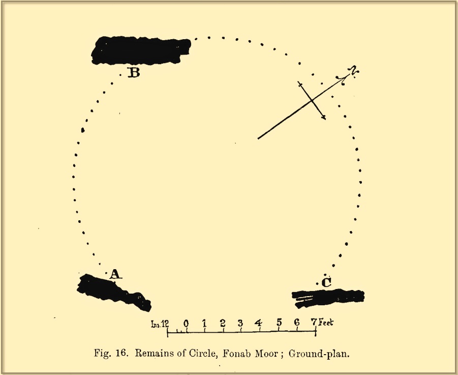
Thom’s initial moonset alignmentThom’s 1980 ground-plan with marker stone
The giant figure of Ben Lawers, if we could see it today, would rise to the southwest 20 miles (32km) from here; and the great pyramidal fairy mountain of Schiehallion would be equinox west, 13 miles (21km) away. Yet curiously when Alexander Thom surveyed the outlying hills, he didn’t think either of these mountains had any worth, astronomically speaking that is. Yet Lawers in particular would be the largest point on the southwestern horizon, rising in the distance, way beyond the wide rolling U-shaped glen of Strathtay to where the landscape changes into more rugged dynamic uplands. And the importance of Lawers as a place in prehistory is shown by the mass of petroglyphs across its slopes—particularly the side you could see from Clachan an Diridh.
Instead, Thom (1967) looked much further to the southwest—south-southwest in fact—where he initially thought that there was an alignment to the major southern moonset ten miles away above the rugged hill of Meall Dubh, framed on either side by the mountain peaks of Meall nam Fuaran and Beinn na Gainimh. Aubrey Burl (1988) told how Thom later discounted this alignment and instead turned his attention a full 180° where a large stone on the hillside to the north-northeast caught his theodolytic eye. This marked an alignment towards the peak of Ben Vrackie:
“There is little doubt,” he wrote, “that this is a lunar site showing perhaps…at the major standstill. Could one side of the southern 6ft high stone possibly have indicated the setting point of the Moon at minor standstill?” (Thom 1990)
Clachan an Diridh in 1851Clachan an Diridh, c.1920
Thom looked at these stones and the landscape with the mind of an astronomer, whereas I’m more in preference of the aborigine who sees the feel of the landscape to discern relationships and meanings. Sometimes, of course, the sky and the landscape come together and that universal mythic union of heaven and Earth finds importance at a site. I have little doubt that such a mythos was once known here, on the moorland plateau, under the clear stars with the darkness reaching to speak with Lawers and other bones of landscape in the solid darkness of mountain silhouettes and fading horizons. Many a sleep at this site would have touched minds with Wonder…
Anyway, all that aside…
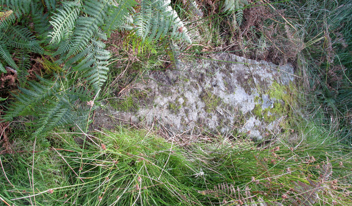
Large fallen stoneSite on the 1899 OS-map
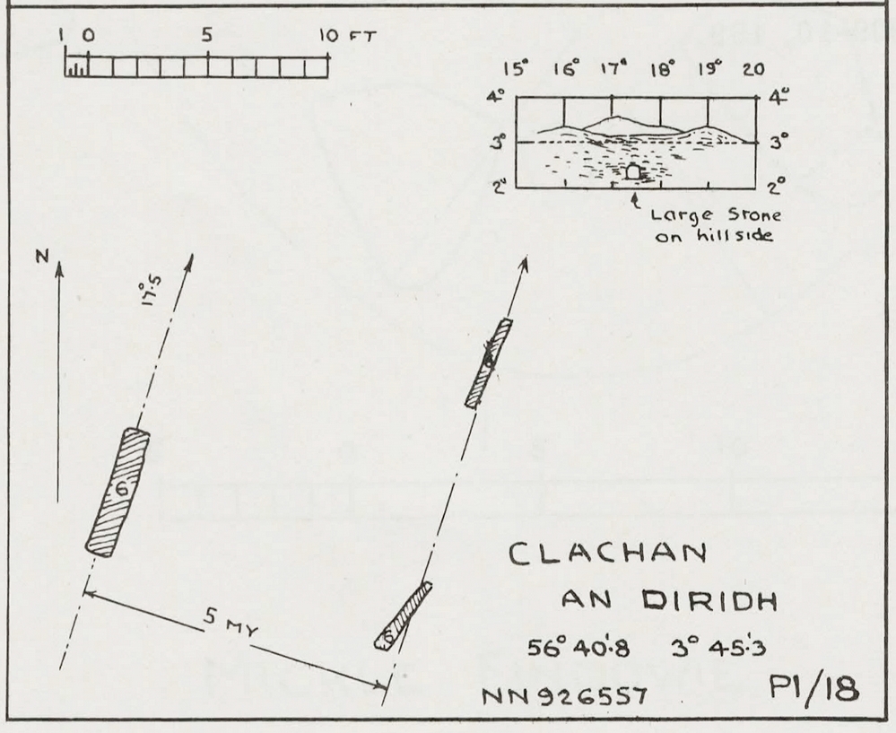
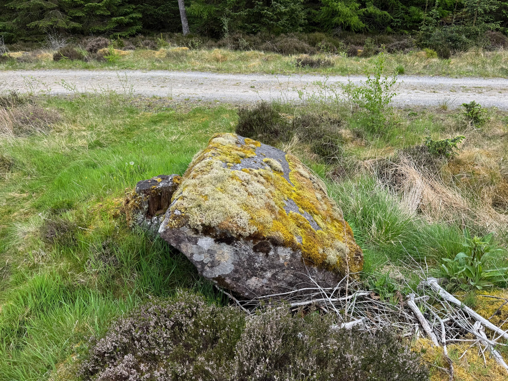
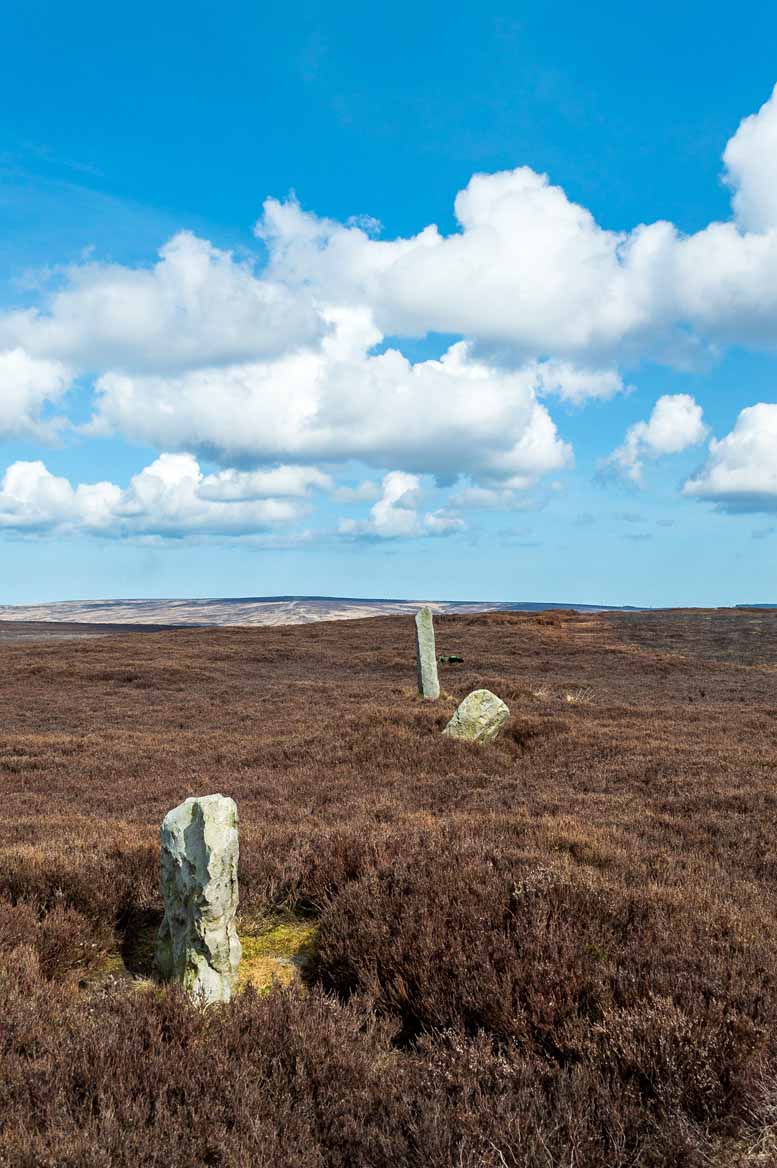
These megaliths have been classified as one of Aubrey Burl’s “four posters”, i.e., a rough square of four megalithic uprights, in spite of there only being three standing stones here. Even when Dan Wilson (1851) wrote about the place there were just three of them. However, down the slope from the stones, just off the recent trackside, there’s a decent contender for the fourth stone lying on its side in the undergrowth, half-covered in moss. It’s certainly fallen or rolled down the slope and its size and shape suggest that it may once have stood upright. Have a thoughtful fondle of it while you’re here.
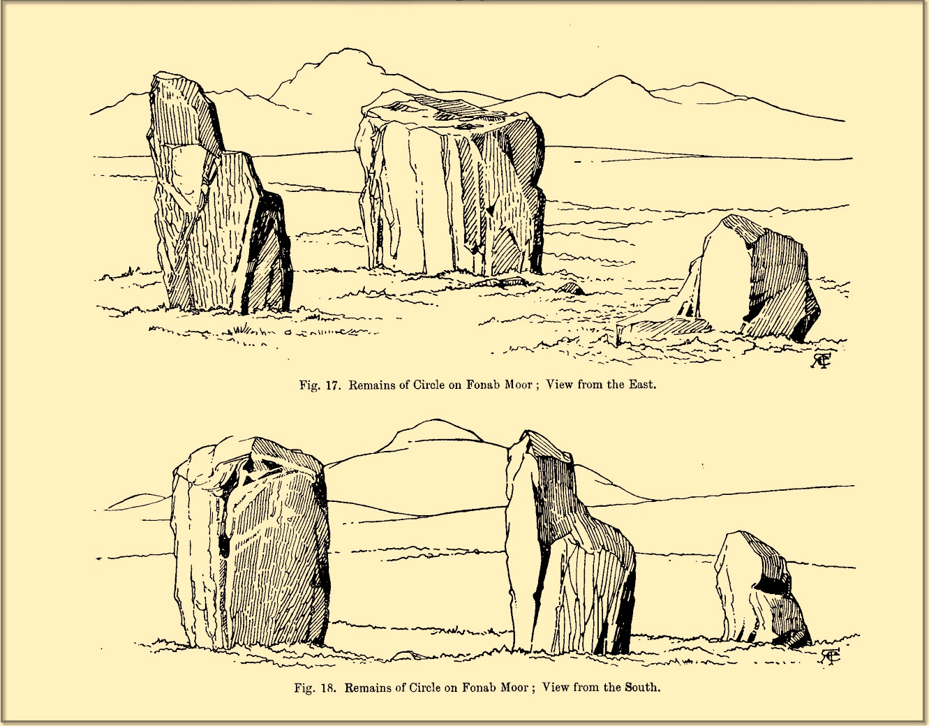
The ‘circle’ was highlighted on the 1899 OS-map and, a few years later, was visited and surveyed by the great Fred Coles (1908) and like Dan Wilson before him, told the view from here to be “very grand.” He continued:
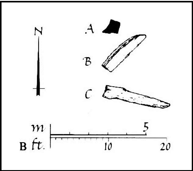
Coles 1906 planColes’ views, from S & E
“In local parlance this group is known as the Four Stones. This must be a fairly old name handed down through some generations; because, for at least fifty-seven years past, only three Standing Stones have remained in situ. These three Stones are arranged as shown in the plan…in a group forming in its now imperfect condition a triangle which, measured from the centres of the Stones, has its SE side 11 feet 6 inches long; its SW side 12 feet 3 inches ; and its north side 16 feet 3 inches. Fragments of the demolished fourth Stone lie about the ground; but there is no clear indication of its original position. The South Stone, A, is 3 feet 7 inches in breadth, 5 feet 10 inches in height, and from 12 to 4 inches in thickness. The West Stone, B, 6 feet in height, measures 5 feet at the back, and 4 feet 10 inches at the front, and is 18 inches in thickness. The East Stone, C, at its outer angle is 3 feet 3 inches above ground, and leans inward. All the blocks are of quartziferous gritty sandstone, the East Stone being particularly rough and fissured. A large fragment lying near it seems to be a portion of it. The Stones are set upon a fairly true Circle with a diameter of 15 feet 4 inches. One feature quickly arrests notice: this is, that the broader faces of these Stones are not set even approximately upon and in line with the circumference, but nearly parallel with each other—an arrangement quite unlike the setting of Stones in the many other Circles hitherto surveyed.”
When Burl (1988) added this site to his Four Posters survey he merely echoed Coles’ early description, adding that, in his view, the standing stones that we see today were probably, originally, “set out on the circumference of a circle 20ft (6.1m) in diameter.”
I think it’s likely that there would have been more prehistoric sites in the vicinity, but a notable oddity is the almost complete absence of other recorded sites anywhere nearby. Of course, if there was anything, those thoughtful Forestry Commission heads would have destroyed it. We are left, simply, with the old but reliable notes of Messrs Dixon (1923) and Mitchell (1925) who told that, in their days, other remains did exist nearby in the form of ancient cairns and hut circles—‘Pictish’ according to tradition. If we’re lucky, some damaged parts of them might still be found at the edges, a short distance to the north west…
Folklore
In Hugh MacMillan’s (1901) gorgeous literary sojourn along Strathtay, he strayed somewhat from his otherwise historical notices by telling that here,
“on the highest part of the moorland…is a group of ‘clachan iobairt’, or stones of worship, where the Druids of old performed their mysterious rites, going round the circle of standing stones from east to west with the sun, or the ‘car deasal’, the lucky side, when they wished to invoke a blessing upon their friends, and going round the circle in the opposite direction, from west to east, the ‘car tuathsel’, or unlucky side, when they wished to pronounce a curse upon their foes.”
Whether this was what Hugh Mitchell (1923) meant when he referred to the traditions surrounding Clachan an Dirirdh we don’t know, but he echoed MacMillan’s account (though made no reference of his words), also adding that it was a site that “was visited on the first of May” or Beltane by some local people….
References:
Burl, Aubrey, Four Posters: Bronze Age Stone Circles of Western Europe, BAR 195: Oxford 1988.
Burl, Aubrey, A Guide to the Stone Circles of Britain, Ireland and Brittany, New Haven & London 1995.
Burl, Aubrey, The Stone Circles of Britain, Ireland and Brittany, Yale University Press 2000.
Dixon, John H., Pitlochry, Past and Present, L. Mackay: Pitlochry 1925.
Kennedy, James, Folklore and Reminiscences of Strathtay and Grandtully, Munro Press: Perth 1927.
Liddell, Colin, Pitlochry – Heritage of a Highland District, PKDL: Perth 1993.
MacMillan, Hugh, The Highland Tay: From its Source to Dunkeld, H. Virtue: London 1901.
Mitchell, Hugh, Pitlochry District: Its Topography, Archaeology and History, L. Mackay: Pitlochry 1923.
Omand, Donald (ed.), The Perthshire Book, Birlinn: Edinburgh 1999.
Stevenson, J., “Prehistory,” in Omand’s The Perthshire Book, Edinburgh 1999.
Thom, Alexander, Megalithic Sites in Britain, Oxford University Press 1967.
Thom, Alexander, Megalithic Lunar Observatories, Oxford University Press 1971.
Thom, A., Thom, A.S. & Burl, H.A.W., Megalithic Rings, BAR: Oxford 1980.
Thom, A., Thom, A.S. & Burl, Aubrey, Stone Rows and Standing Stones – volume 2, BAR: Oxford 1990.
Wilson, Daniel, The Archaeology and Prehistoric Annals of Scotland, Sutherland & Knox: Edinburgh 1851.
Acknowledgements: Huge thanks for use of the Ordnance Survey map in this site profile, reproduced with the kind permission of the National Library of Scotland.
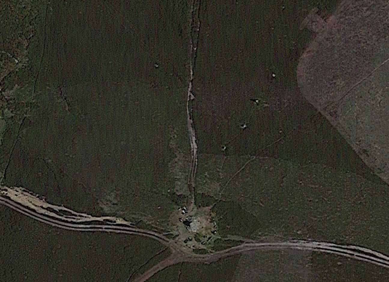
From Pickering take the moor road towards Whitby (A169) for approx. 12 miles. After passing the Fylingdales Early Warning radar on the right (you can’t miss it), the road dips down to cross Eller Beck as a dog leg. After a half mile turn off left (west) towards Goathland (signposted). Follow the road under the North Yorks Moor railway bridge and after a third-of-a-mile the road turns slightly left. Park in the little layby and follow the track onto the moors. Cross the small stream and walk along the narrow track through gorgeous heather for a mile and a half. Ahead you will see Simon Howe prominent on a ridge, with a stone row leading to it.
Archaeology & History
Not included in either of the giant megalithic alignments surveys of Burl or Thom, it seems that the first archaeological reference to this site was made by Raymond Hayes (1988). He visited the site in 1947, shortly after a moorland fire had cleared away all the vegetation, allowing for a clearer view of the stones and, after his brief description of the adjacent Simon Howe tomb, he told that,
“The ridge is also the site of what is an unusual feature for the moors: a stone alignment consisting of three, formerly five upright stones that lead to a low eroded cairn c.65m to the south(west). A moor fire in 1947 revealed the fourth, fallen stone, and I was able to locate the socket of a fifth.”
Raymond Hayes 1947 photoStone row on GoogleEarth
From hereon, Hayes seemed to more interested in seeking out and describing a large number of flints that he found scattered on the ground around Simon Howe and its associated monoliths than the stones themselves. Very sad… The exact position of the missing fifth stone seems to be shown on Hayes’ plan as being closest to the cairn, about 10-15 yards away, but no trace of this remains. However, of the remaining monoliths, they are all clearly visible from the air on Google Earth!
The most southerly of the four stones (SE 83016 98119) stands just over 3 feet tall and the second upright, leaning at an angle, is just slightly taller, with the tallest of the three uprights at the northeastern end, being some 6 feet tall. The fourth fallen stone (SE 83031 98142) lies just beyond this in the heather and which, if resurrected, would stand some 4 feet in height. The length of the row, stone-to-stone, is just over 29 yards (26.6m). I’m not aware if this site has ever been assessed as having an astronomical function, but its angle to the northeast might suggest a lunar rising. Perhaps more pertinent would be another prehistoric cairn that can be seen less than 100 yards away past the northern end of the stone row: as North is the cardinal direction symbolizing Death in traditional lore…
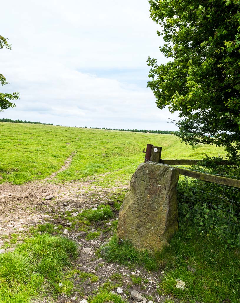
Roughly halfway between the staggering standing stone at Kintraw and the farmhouse of Salachary a coupla miles east along the A816 road to Kilmartin, a small overgrown car park nearly hides on the south-side of the road, just below the forestry. 50 yards west of this, a small track winds uphill. 650 yards (0.6km) up here, once it levels out, a hairpin in the track veers NW; ignore it, instead walking into the marshy grass in front of you (south) for 50-60 yards up and round the small rocky crag. Once you get round the edge of this, immediately east, you’ll see one of the tall monoliths 50 yards ahead of you.
Archaeology & History
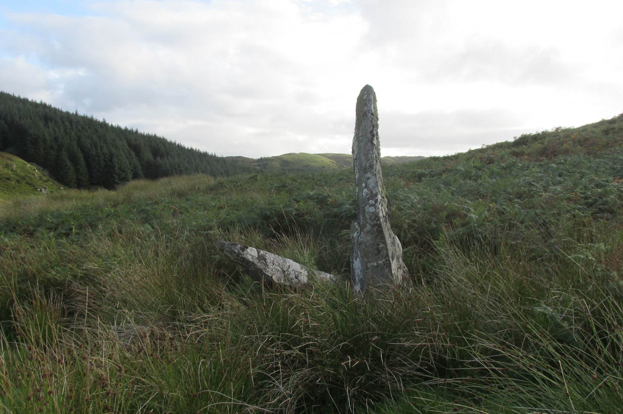
Rediscovered in recent times by Marion Campbell (1962), this damaged row of three tall standing stones is cited in Swarbrick’s (2012) poorly-arranged survey as being “difficult to find in broken ground”; although patience brings the stones clearly into sight for any explorer. They’re big too! Sadly only one of them still remains fully upright—but that one’s nearly 9 feet tall!
In Miss Campbell’s initial description of the site, following their rediscovery, she told how,
“A chance sighting led to the discovery of a group of three monoliths, one erect, one sloping and one prostrate, on the West side of a wide glen leading S from the upper part of the Bealach Mor; the site commands a fine view into the northern hills. The spot is about 550ft above sea level and this is therefore the highest group of standing stones so far recorded in the area.
“The erect stone is 8ft 4in x 2ft x 1 ft, lozenge-shaped in section, with a pointed top. The leaning stone, also lozenge-shaped, is 10ft x 1ft 8in x 1ft, and pointed. The fallen stone is over 11ft x 2ft wide, too deeply buried in turf for the thickness to he measured. The stones appear to have stood in line, the nearest points of the first and third stones 9ft apart and the line joining them running north and south. Along a ridge running S behind the stones are a number of small ruins, oval and rectangular, in old cultivations. No surviving placename has been recovered for the site so far.”
Section of the fallen stoneLooking west
Indeed, no subsequent investigation has led to either an early name nor any traditions about the site, and the stones cannot be found on any early maps of the area. A pity, as they’re quite impressive stones and would have had some old stories known of them in ages gone by.
Twenty years after Miss Campbell’s discovery, in May 1982, the stones were visited and surveyed by the Royal Commission lads. Their description very much tallied with Miss Campbell’s, but it’s worth citing anyway. They told us that:
“On a terrace on the W side of an unnamed valley to the S of Bealach Mor and about 850m SW of Salachary, there is a setting of three large standing stones which is aligned from N to S. Only the N stone is still upright; it measures 0.7m by 0.72m at the base and rises with straight sides to a pointed top at a height of 2.75m. The central stone is of similar proportions, but it now leans to the NE at an angle of about 15° to the horizontal. The S stone, which measures 3.4m by 0.65m has fallen with its top to the SE.”
Royal Commission planAlexander Thom’s plan
Around the same time, Clive Ruggles (1984) assessed the Salachary stones for any potential astronomical alignments and found—as Alexander Thom & Aubrey Burl did in their own survey (1990)—that as they pointed virtually north-south they stood beyond any solar or lunar functions. Thom found the stones align almost perfectly north-south, with a notch in the southern horizon at 178°, and on the northern horizon the hilltop of Meall Reamhar at 2° west of north. This northern line may relate to the airt of death, although no other immediate archaeological remains have been found to fortify this idea (however, other unrecorded standing stones are close by and their relationship with Salachary has yet to be adequately assessed).
Aubrey Burl’s first description of this stone row told us:
“There are three stones in a N-S row situated on a terrace on the W side of a glen. The N stone, with a pointed top, stands 8ft 4 (2.5m) high. The central stone leans dramatically at 20°. It is 10ft (3m) in length. The S stone is prostrate and half-buried. It is 11ft (3.4m) long. The row is about 13ft (4m) long. From the site there is a fine view of the northern hills.”
Looking north
In truth, the main north-south axis relates to the more open geological avenue of the landscape. Both the east and west are all but blocked by crags and hills, and the stones seem to have been positioned to echo the hollowed section of the landscape. The land runs in curious geological folds and has a distinct genius loci which I enjoyed in differing (usually wet) conditions when I used to live nearby. The site is well worth a walkabout if you’re in the area – and there are more unrecorded stones still hiding in Nature’s rocky folds nearby.
References:
Burl, Aubrey, From Carnac to Callanish, Yale University Press 1993.
Campbell, M. & Sandeman, M., “Mid Argyll: An Archaeological Survey,” in Proceedings Society Antiquaries Scotland, volume 95, 1964.
Campbell, Marian, ‘Salachary, Kintraw’, in Discovery & Excavation Scotland, 1962.
Ferguson, Lesley, “A Catalogue of the Alexander Thom Archive Held in the National Monuments Record of Scotland,” in Records in Stone (ed. C. Ruggles), Cambridge University Press 1988.
Royal Commission on the Ancient & Historical Monuments of Scotland, Argyll – volume 6: Mid-Argyll and Cowal, HMSO: Edinburgh 1988.
Ruggles, Clive L.N., Megalithic Astronomy, BAR: Oxford 1984.
Ruggles, Clive L.N., “The Stone Alignments of Argyll,” in Records in Stone (ed. C. Ruggles), Cambridge University Press 1988.
Swarbrick, Olaf, A Gazetteer of Prehistoric Standing Stones in Great Britain, BAR: Oxford 2012.
Thom, A., Thom, A.S. & Burl, Aubrey, Stone Rows and Standing Stones – volume 1, BAR: Oxford 1990.
Weston, Garth, Monuments and Mountains, Ashridge: Bakewell 2007.
Acknowledgements: This site profile could not have been written without the help and of Nina Harris, Paul Hornby, Frank Mercer and Belinda Sales.
From Pickering, take the A169 towards Whitby. When you get to the Car Park at the ‘Hole-of-Horcum’ – (you can’t miss it), park the car and walk North along the side of the road towards Whitby. After 60 yds, take the track East. Follow this for approximately a mile until the track splits. Take the concrete track left towards the farm-house of ‘Newgate Foot’. Go through the yard past the house on the right, and you will come to a stream and a gate. Enter the field on the right and up the track. The stones are in front of you.
Archaeology & History
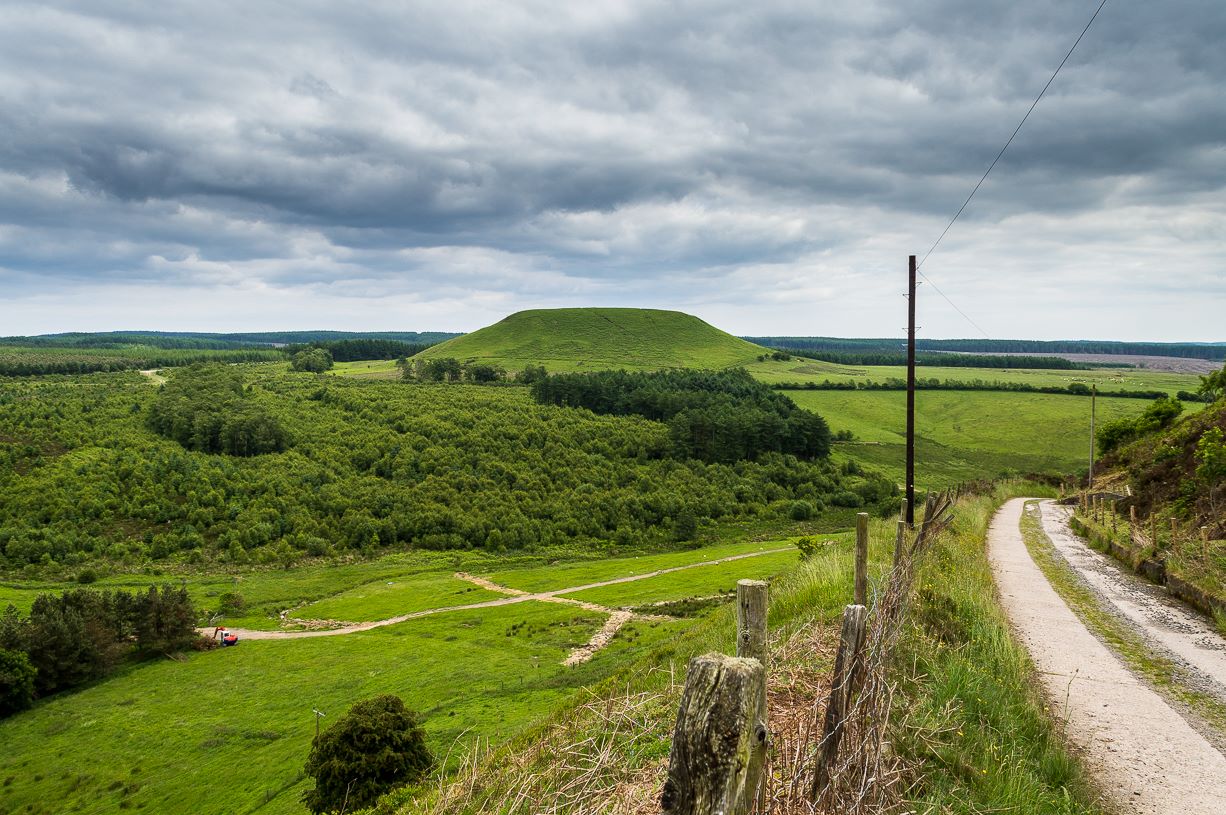
The great rounded hill of Blakey Topping—recorded as early as 1233 CE and meaning the ‘black mound’ or ‘black meeting-place’— has the ruins of a stone circle living several hundred yards to its south, little-known to many. The early writer George Young (1817) seemed to come close here, mentioning the ‘druidic’ standing stones of Blakey Moor and district, but gave no specific indication of the ruinous ring we’re visiting here. Instead, the first real description was penned by Robert Knox (1855) who, at the time of writing, was under the academic spell of druidism: prevalent as it was amongst most universities and places of learning back then. Also, beset by the equally sad plague of Biblical comparitivism—beloved even to this day by halfwits—Knox’s formula about this ancient ring was founded on the druidical reverence of Blakey Topping as a site beneath which our Bronze age tribal ancestors erected their stones with the rounded hill immediately to the north, as signified by its early name, black. (In early place-names, ‘black’ and its variants—dubh, dove, etc—relates to the cardinal direction of ‘north’ and actually means ‘shining’; and white or ban is ‘south’, when both elements are located in relative proximity.) Knox told us:
“At the southwest side of this arch-Druid’s tomb-like hill (Blakey Topping) a far more conspicuous cluster of larger Druid stones occurs; here three pillars form a triangle…and a smaller one…stands one hundred and fifty paces east of these nearer to the farmhouse there. These single stones, possibly, once formed part of a circle… The diameter of a circle formed on this triangle of stones would be about fifty-five feet; but as these pillars form a nearly equilateral triangle, the number of stones in that circle cannot now be correctly ascertained, if, indeed, they ever formed part of a circle…
“These three sandstone pillars, untouched by tools…are much weather-worn; and hence it may be inferred that they are very ancient. I shall only add that the tallest pillar here is nine feet high, from two-and-a-half to three feet wide, and rom fifteen to twenty inches thick, and is the tallest ancient pillar next to the celebrated one in Rudston churchyard, now standing in the eastern part of Yorkshire. When I last visited the Blakey Topping Druid-stones in 1836, I learned that the farmer, on whose ground they stand, “had talked about breaking the three large ones to pieces,” and perhaps nothing but the trouble of doing so has hitherto preserved them, and many others. I told him what had been their use, and begged he would preserve them.”
Stone re-used as gatepost (James Elkington)
And thankfully they remain there to this day! Around the same time of Mr Knox’s visit, the Ordnance Survey lads came here too and, in 1854, highlighted the remaining ‘Druidical Stones’ on the first map of the area. But references to the stones from here onwards are sparse and add nothing pertinent to its archaeomythic status. It was a Mr & Mrs Elgee (1930) who were the next to tell us about the site in their exposition on Yorkshire archaeology. They wrote:
“Three large standing stones about 6 feet high on the south-west side of Blakey Topping…are the remains of a circle about 18 yards in diameter. Two or three hollows in the ground indicate the position of other stones, some of which are serving as gateposts nearby. Others have been broken up to help build a wall. These stones are associated with a large settlement sites similar to (one) on Danby Rigg not very far from the imposing Bridestones and approached by an ancient trackway known as the Old Wife’s Trod.”
The general interpretation by the great megalithic archaeologists Aubrey Burl, John Barnatt and their fellow associates, is that these stones are the remains of a stone circle – which seems apt. But of even greater importance seems to be the great hill of Blakey Topping itself, to which this olde ring no doubt related to. Many other prehsitoric sites once scattered this area, but sadly most of them have been destroyed.
References:
Barnatt, John, Stone Circles of Britain (2 volumes), BAR: Oxford 1989.
Burl, Aubrey, A Guide to the Stone Circles of Britain, Ireland and Brittany, New Haven & London 1995.
Burl, Aubrey, The Stone Circles of Britain, Ireland and Brittany, Yale University Press 2000.
Elgee, F., Early Man in Northeast Yorkshire, Frank Bellows: Gloucester 1930.
Elgee, F. & H.W., The Archaeology of Yorkshire, Methuen: London 1933.
Gutch, Mrs E., Examples of Printed Folklore Concerning the North Riding of Yorkshire, David Nutt: London 1899.
Acknowledgements: Big thanks to the photographer James Elkington, for use of his photos in this profile. Cheers mate. Also, accreditation of early OS-map usage, reproduced with the permission of the National Library of Scotland.
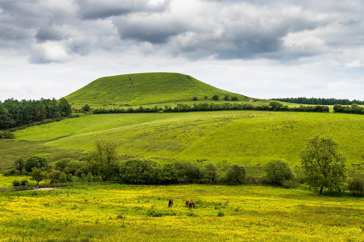
From Pickering, take the A169 towards Whitby. When you get to the Car Park at the ‘Hole-of-Horcum’ – (you can’t miss it), park the car and walk North along the side of the road towards Whitby. After 60 yds, take the track East. Follow this for approximately a mile until the track splits. Take the concrete track left towards the farmhouse of ‘Newgate Foot’. Go through the yard past the house on the right, and you will come to a stream and a gate and there, ahead of you, rises Blakey Topping…
Archaeology & History
The giant hill of Blakey Topping was recorded as early as 1233 CE and in a simplistic style just means the ‘black mound’; but this derivation has additional ingredients, implying it as a ‘black meeting-place’ or moot. Black in the etymological sense also implies ‘shining’ and it may also relate to the northern airt of black (meaning death, darkness, north, etc), when you’re stood at the ruined stone circle 400 yards to the south. But I’m speculating here…
Several 19th century antiquarians suggested there may have once been a cairn on top of the hill, but others who’ve explored this idea seem to have put it to bed.
Folklore
This great hill is well recognised amongst local people and, to this day, its animistic creation myths and other folklore elements are still spoken. When the photographer James Elkington recently visited the nearby standing stones, he bumped into the old farmer who told him how his father had seen the faerie-folk on the hill many years back. And its modern reputation as a gorgeous site adds to such lore, which dates way back.
In Frank & Harriett Elgee’s (1933) archaeology work, they narrated the old creation myth that local people used to tell of this great hill,
“A witch story related by a native 25 years ago attempts to explain two conspicuous natural features two miles apart on Pickering Moor; Blakey Topping, an isolated hill, and the Hole of Horcum, a deep basin-shaped valley. The local witch had sold her soul to the devil on the usual terms, but when he claimed it, she refused to give it up, and flew over the moors, with the devil in hot pursuit. Overtake her he could not, so he grabbed up a handful of earth and flung it at her. he missed his aim and she escaped. The Hole of Horcum remains to prove where he tore up the earth and Blakey Topping where it fell to the ground.
“From our point of view the significance of this story lies in the fact that between the Hole and the Topping there is a Bronze Age settlement site at Blakey Farm, with its stone circle. The rough trackway leading from the Hole to the circle is known as the Old Wife’s Way, presumably also marking the witch’s flight. This, together with other Old Wife’s Ways, preserves as it were Bronze Age church tracks”.
Looking up from the SW (James Elkington)
A relative variation on this tells that the Hole of Horcum was made by the local giant, Wade. He was having a row with his wife, Bell, and got so angry that he scooped out a lump of earth and threw it at her. The huge geological feature known as the Hole of Horcum is the dip left where he scooped out the earth, and Blakey topping, the clod itself, resting in situ where it landed. A christian appropriation of the story replaces Wade and his wife with their ‘devil’: a puerile element unworthy of serious consideration.
In more recent times, the old geomancer Guy Ragland Phillips (1976; 1985) found that a number of alignments, or leys (known as a ‘node’), centred on Blakey Topping: twelve in all, reaching out and crossing numerous holy wells, prehistoric tumuli, standing stones, etc. The precision of the alignments is questionable, yet the matter of the hill being a centre-point, or omphalos, would seem moreso than not.
References:
Elgee, F. & H.W., The Archaeology of Yorkshire, Methuen: London 1933.
Phillips, Guy Ragland, Brigantia, RKP: London 1976.
Phillips, Guy Ragland, The Unpolluted God, Northern Lights: Pocklington 1987.
Smith, A.H., The Place-Names of the North Riding of Yorkshire, Cambridge University Press 1928.
Standing Stone (missing): OS Grid Reference – SE 881 947
Archaeology & History
A number of standing stones were reported by regional historian Robert Knox (1855) in his antiquarian work of this area, but forestry and vandalism has seen the demise of some. This one, however, may possibly still be found, laid down somewhere on the tops, along the ridge aptly-named as Stone Hill Head. Where precisely it might be, we know not—but one of you Yorkshire antiquarian ramblers might be able to find and resurrect it by following old Mr Knox’s notes. Writing extensively of the ancient remains around nearby Blakey Topping this is what he told us of the Stone Hill Head monolith:
“The pillar…standing erect, is five and a half feet high, three broad, and from ten inches to two feet thick. This is much corroded either by natural decomposition, or designedly made so by manual labour; some of the holes in it being circular, as if intended to fit the heads of human beings into them, at the time of their immolation, while laid prostrate on the ground… This stone stands northeast from Blakey Topping, distant about six furlongs, and is the furthest pillar in this collection from that hill.”
If the real explorers amongst you manage to rediscover the stone, please let us know.
References:
Knox, Robert, Descriptions Geological, Topographical and Antiquarian in Eastern Yorkshire, London 1855.
This fascinating looking carving (in my personal Top 10 of all-time favourites cup-and-rings in the UK!) was unfortunately destroyed sometime between 1918 and 1920. A huge pity, as the design on the rock is almost unique in its ‘linear’ system of cups running a considerable length across the surface of the stone (like the similar design found at Old Bewick in Northumberland).
Wilson’s 1851 drawing of the Witches’ StoneSimpson’s 1866 drawing of the Witches Stone
Shown first of all on Kirkwood’s Environs of Edinburgh map in 1817 (above), this legendary rock was found amidst a cluster of other cup-and-ring stones at Tormain (some are still there) and was initially said by Daniel Wilson (1851) to have been the giant capstone of a cromlech that once stood here, but whose structure had fallen away. This idea is implied in the earliest drawing we have of the stone in Wilson’s magnum opus (above); Sir J.Y. Simpson (1867) gave us a similar impression with his drawing a few years later. But upon visiting the Witches Stone just as his book was going to the press, Mr Wilson visited the site and proclaimed that he “altogether doubted if they are the remains of a cromlech”, and what rested here were more probably just fascinating geological remains, with even more fascinating carvings on top!
In the years that followed Wilson’s initial description, the Witches Stone was visited and described by a number of eager antiquarians. Simpson (1867) gave us a quite revealing account, telling:
“On the farm of Bonnington, about a mile beyond the village of Ratho…are the remains of ‘this partially ruined cromlech’…with the capstones partially displaced, as if it had slid backwards upon the oblique plane of the huge stones or stone which still supports it. Two or three large blocks lie in front of the present props. Its site occupies a most commanding view of the valley of the Almond, and of the country and hills beyond. The large capstone is a block of secondary basalt or whinstone, about twelve feet long, ten in breadth and two in thickness. Its upper surface has sculptured along its median line a long row of some twenty-two cup-cuttings; and two more cup-cuttings are placed laterally: one, half a foot to the left of the central row and at its base; the other, two feet to the right of the tenth central cup and near the edge of the block. The largest of the cups are about three inches in diameter and half an inch in depth; but most of them are smaller and shallower than this…”
A few years later another early petroglyph authority, J. Romilly Allen (1882), visited the Witches Stone and found “an Ordnance bench mark (had been) cut on the stone itself”! He then continued with his own description of this once-important megalithic site:
“The Witch’s Stone is a natural boulder of whinstone, rounded and smoothed by glacial action, whoso upper surface slopes at an angle of about 35° with the horizon. The length of the sloping face is 8 feet and at the top is a flat place 2 feet wide. The breadth of the stone is 11 feet 3 inches at the upper end, and 4 feet at the lower end. The thickness varies from 2 to 3 feet. The highest part of the stone is 6 feet 6 inches above the ground, and the lowest 1 foot 6 inches. It rests on what has originally been a portion of the same boulder, but is now a mass of whinstone broken up into several fragments, which serve as supports to prop up the stone above. Viewed from the north side the whole presents the appearance of a cromlech, the upper stone forming the cap, and the disintegrated portion below the supports. This notion, however, will be clearly seen to be erroneous on looking at it from the opposite side, as shown on the accompanying sketch…where the crack separating the two portions of the boulder is very apparent… The sculpturings consist of twenty-four cups varying in diameter from 1½ to 3 inches. Twenty-two of these cups are arranged in an approximately straight line along the sloping face of the stone, and divide it into two almost equal parts. The two remaining cups lie, one 7½ inches to the left of the lowest cup of the central row, and the other 2 feet 3 inches to the right of the ninth cup up the stone… The field in which the Witch’s Stone is situated is called “Knock-about.” The sloping face of the stone has been much polished by the practice of people climbing on to the top and sliding down. Some of the cups are almost obliterated in consequence. The stone forms a very prominent feature in the view, and must always have attracted attention from its peculiar shape.”
Some twenty years after Allen, the megalithomaniac Fred Coles (1903) came and checked the Witches Stone out for himself and, as happens, had a few additional things to say about the place:
“Although this huge boulder and its cup-marks have been more than once figured and described, I found, on a close examination of the broad surface of the Stone, that none of the illustrations showed the cup-marks in their exact relation to each other, nor in their true relation to the contour of the Stone. The drawing shown above…was made after a careful measurement by triangulation of the Stone; and it is claimed to be the first that shows that the cups, two and twenty in number, are not disposed in one continuous line, but that thirteen follow each other from the high south edge of the stone for a distance of exactly 6 feet, and nine others lie a few inches to the west, occupying a space 3 feet long of the overcurving edge of the north end. It is further shown that, at a point 2 feet 3 inches west of the ninth cup-mark, there is another one quite as large as the largest in the rows near the middle of the Stone. The south edge (A B) has slipped a little down from its original height, the boulder being frost-split horizontally; its height there above ground is 8 feet. The northern and narrower end is about 2 feet above ground, and does not touch the ground, as it rests upon its lower portion, beyond which it projects a few inches. The cup-marks run due north.”
Fred Coles 1903 drawing
If the Witches Stone was in fact a natural outcrop stone and not a cromlech, this very last point telling that “the cup-marks run due north” probably had much greater importance than a mere compass-bearing to the people who etched this carving. For in pre-christian religious structures across the northern hemisphere, north is commonly representative of death and the land of the gods. In magickal rites “it is the place of greatest symbolic darkness,” as neither sun nor moon ever rise or set there. Additionally, north is the place where, in shamanic traditions, the heavens are tied to the Earth: the cosmic axis itself that links heaven, Earth and underworld. In early neolithic traditions this mythic structure was probably endemic. Whether its magickal relevance was intended here, at this stone, we will probably never know…
Folklore
Folklore tells that the Witches Stone was one of the sites used in magickal rites by the Scottish occultist, Michael Scot. J.R. Allen’s (1882) description of “the sloping face of the stone has been much polished by the practice of people climbing on to the top and sliding down,” may relate to folk memory of fertility rites once practiced here, as found at similarly carved rocks in the UK and across the world.
McLean, Adam, The Standing Stones of the Lothians, Megalithic Research Publications: Edinburgh no date (c.1978).
Morris, Ronald W.B., The Prehistoric Rock Art of Southern Scotland, BAR: Oxford 1981.
Royal Commission on the Ancient & Historical Monuments of Scotland, Inventory of Monuments and Constructions in the Counties of Midlothian and West Lothian, HMSO: Edinburgh 1929.
Simpson, James, Archaic Sculpturings of Cups, Circles, etc., Upon Stones and Rocks in Scotland, England and other Countries, Edmonston & Douglas: Edinburgh 1867.
Aerial image showing faint outline of Blackheath circle
From Todmorden, take the road to Hebden Bridge (A646) less than half-mile outta town and just as road goes uphill, watch for the left turn up to Cross Stone. This is one helluva superb steep, winding road if you aint been up it before (which, somehow, I used to be able to cycle up without a break!). As you reach the hamlet of Cross Stone, bear uphill again (left) until you reach the top-end of the golf course, where you’ll see a footpath on your left that runs alongside the course. Walk on this until it reaches a stile. Walk up the wallside and onto the course itself – and there, in front of you, in the middle of the damn golf course, you’ll see the very denuded remains of a once fine prehistoric monument (it’s situation, quite frankly, is a disgrace – and any pagans or historians who feel similarly should complain to Calderdale Council about the lack of preservation here; as the more of us who do, the more they’ll have to pay attention and perhaps do something about it).
Archaeology & History
Very little can be seen of this once important site thanks to the important golf course built right on top of this once sacred site. Thankfully we have an extensive description of the place that was done by J. Lawson Russell (1906) from which this profile account — and every other account for that matter! — draws heavily upon. It was included in Aubrey Burl’s magnum opus (2000) as a stone circle, but this isn’t strictly correct and is more accurately a cairn circle or ring cairn monument.
Blackheath Circle’s shallow semicircular bankBlackheath circle, looking SE
It was thought in times past to have been a monument built by the Romans (hence the earlier title of ‘Roman Barrow’), but its origins were much earlier than those scruffy incomers! Its other local folk name, the “Frying Pan Circle” is, like its namesake at Morley, an etymological curiosity relating to the flat ground left in the wake of its shape: flat, circular, with raised edges surrounding it, not unlike a frying pan.
It was accurately described for the first time by Robert Law (1897), who later broadened his account of the site a year later in a paper he wrote for the Yorkshire Geological Society (1899) after an excavation here. Mr Law and others explored the centre of the ring where they believed it most probable to find remains of some form or another — and they weren’t to be disappointed! The following is taken directly from his lengthy article:
“On Thursday, July 7th of this year (1898), a very interesting and important archaeological discovery was made on a portion of land known as Higher Cross Stone Farm, belonging to Mr. Sutcliffe, of Todmorden. In a field on this farm, called Black Heath, a ring circle, made of earth, has long been known to exist, and has gone by the name of the “Frying Pan.” No history or tradition exists as to the origin of this circle, and various speculations have from time to time been indulged in by the residents. Some have called it a Roman Camp, others a fairy circle, others a circus ring, made to break in horses; but the excavations prove it to be a burial place of prehistoric times. Mr. Tattersall Wilkinson, of Burnley, a well-known archaeologist of considerable experience on ring circles, along with the writer of this article, came to the conclusion, on hearing of this circle, that it probably contained human remains, and an excavating party was organised to meet on the spot on the day above mentioned. This party met at the appointed time, and the plan of operations was to find the centre of the circle, by means of a tape, then to dig a circular trench about three feet from the centre, in which space it was thought the remains would lie. The ring was nearly a perfect circle. It was raised conspicuously above the ground. The rim of raised earth was about three feet wide, and the diameter of the whole circle was thirty yards. After the digging had been going on for a short time, burnt soil and charcoal were met with, and the top of an urn was exposed to view. The diggers then went to work with the greatest possible care, and very soon a beautiful urn was laid bare exactly in the centre of the ring. The urn was embedded in charcoal and calcined bones. It was ten inches high and nine inches at the top, tapering to about three inches wide at the bottom. There was a rim or collar in the upper part of the um about three inches deep, which stood out about one inch in relief from the lower part of it. The collar was ornamented, probably by a pointed stick, with the herring-bone pattern. The outer part of the um was plain. In clearing away the debris from the urn another one was discovered, different in pattern and less in size, but in a very perfect state of preservation.
“About two feet from this, on the opposite side of the central urn, another um was discovered and laid bare, by carefully digging round it with a trowel. This urn was also in a good state of preservation, and about the size of the second one, but differently ornamented. These smaller urns were the same shape as the larger central one, but the ornamentations were not so fine, and they were made of inferior clay. On the south side of the circle, about two feet from the centre, another urn was discovered, but it appeared to be insufficiently baked when manufactured, and had decomposed and crumbled into dust. From the inside of this urn a large quantity of calcined human bones and charcoal was dug up, but the bones were very fragmentary, and the sex of the person to whom the bones belonged could not be determined. Several portions of cranium, rib bones, and lower and upper leg bones were found among the debris.
“Within a few inches of this urn two small (so called) incense cups were found. One of them was very perfect and in an excellent state of preservation and was beautifully ornamented all over. These cups were about three inches in height and three and a half inches in diameter, but tapered a little at the bottom. Indications of three other urns were observed, but they were so much decomposed that little or nothing could be made of them. The others seemed to be arranged about the large central urn and about two feet apart. When the earth had been cleared away from the three perfect urns, and before they had been removed, several photographs were taken of them in situ. One of the smaller urns leaned a little to the south. Several pieces of flint and chert were dug out of the excavation. The urns and incense cups being removed were put into baskets and conveyed to Todmorden, where they were re-photographed and placed in the Free Library for their safe keeping.
“On July 13th, six days after the “find,” the urns were opened at the Co-operative Hall, Todmorden, before a very large gathering of scientific ladies and gentlemen drawn from the surrounding districts. Mr Tattersall Wilkinson, Dr. Crump of Burnley, and the author were entrusted with the opening of the urns.
“The largest one, which was of superior make to the other, was the first to be operated upon. The work was tedious and was done in the most careful way possible. Each operator commenced to pick out by means of a small pocket knife the substances deposited in the urns, and the material was closely examined as it fell out on the table. For the first half-hour or so nothing particular was found. The contents which had been so far dug out were portions of broken urns of a similar pattern to the urn that was being examined, but were not portions of it and must have been placed there as filling-in material. Along with these urn fragments there was some dark brown sand, which appeared to have been burnt, quantities of bituminous soil, small fragments of bones, and bits of charcoal. As the examining party dug deeper into the urn human bones became more numerous and in larger fragments and of a more determinable character, and this went on until the urn had been half emptied. The rest of the contents of the urn then showed signs of being almost entirely calcined bones, and bone after bone was picked out, examined, and laid on the table. Among these bones were fragments of various sizes: of cranium, portions of scapula, pelvic bones, femur, tibia and other bones of the legs. Besides these there were fragments of ribs and perfect toe bones.
“Presently a small cup was laid bare inside the urn, and a few pokes with the knife so far emptied it of its contents that an ancient relic could be seen which differed from any that had yet been found. A moment later a piece of metal was picked out of the cup resembling a spear head. It was about 2½ inches long and 1¼ inches wide at one end, and tapered to a point at the other. It was thin and flat and sharp at the sides and point. It contained a rivet at the two extremities and another one about half way up one side. A bronze pin was also found about the same time as this piece of metal, and on careful examination the metal and the pin were made out to be a bronze brooch, the pin having probably been detached in extracting it from the bones in the cup. Besides this brooch about a dozen beads of a necklace were found, which were chiefly of a rounded shape and about half an inch in diameter. Some of the beads seem to have been made of jet, and some of bone, and were more or less rudely carved. A bone pin was next brought to light. It was almost two inches in length and the eighth of an inch in diameter at one end, tapering towards a point at the other. It was cylindrical in form and slightly curved. The fact of all these ornaments having been carefully placed in the cup and buried with the urn point to the cup having been used as a utensil in which to preserve what was considered of great value. Several human teeth were also found in this cup.
“The opening of the two inferior urns proved that they contained nothing more than the sweepings up of the funeral pile which probably took place after the calcined bones had been placed in the more important urn.
“Since this discovery was made a beautifully-formed flint arrowhead of the leaf-shaped pattern has been found in the same hole from which the urns were dug. There have also been two or three more urns discovered within the same circle, but their contents have not yet been disclosed.”
Early 1899 photo of the Blackheath urnsBlackheath urns on display, c.1911
They had to wait a few more years before a more complete account described the contents of the “two or three more urns” at Blackheath’s circle. That duty fell to Mr J. Lawson Russell (1906), who, after further excavations, wrote the most detailed and complete account of the place.
Following the successful discoveries in 1898, Messrs. Russell, Law, Wilkinson and others made a “further systematic examination of the whole circle”, which was then subsequently wrote up in Ling Roth’s Prehistoric Halifax. The following is a detailed account of that second dig:
“The first step in the systematic examination was the breaking up of the circle into quadrants. This we did by running deep trenches north, east, south and west. The turf was then removed and these quadrants dealt with seriatim. The diameter of the circle was as nearly as possible 100ft (30.5m), i.e. measuring from ridge to ridge, but the slight mound which marked the circumference sloped gently further into the general level of the field. Eight or nine deep furrows ran through the circle, from north to south, cutting the vallum up into segments and ploughing the enclosed area with their parallels. The method we followed was to trench till we came to soil which had never been disturbed. Generally about two spade grafts brought us to stiff glacial (?) clay. When we came upon an urn its position was carefully observed with reference to the centre and noted on a plan ; the earth was removed by trenching round the um, which was photographed in situ when sufficiently defined. The urns were not deeply placed, some of them being only six inches from the surface, none deeper than from 18in to 2ft (46 cm to 61 cm), and all of them without exception were set in the ground upright on their bases, not inverted. There was in the centre an urn, and this was surrounded at a radius of 2ft by a ring of deposits; two having urns, the others either having no urn at all or showing signs only of disintegrated pottery. At a distance of about 10 ft. from the centre another series of deposits was radially arranged, but all to the east side of the north to south centre line. It will be seen that, if we leave out of account the urn found in the vallum in the north-west quadrant, all the urns and deposits save one have been placed to the east of the north to south centre line.
“An extensive floor of charcoal, sometimes an inch to two inches in thickness, was defined to the north of the centre, and two deep pits were located about 16ft (4-9 m) from the centre, one in the north-east and one in the south-east quadrant. Close to that deep spot in the south-east quadrant we found a curiously baked surface which we attempted to photograph. A group of urns, one of which was a fine covered specimen, lay in line going due east from the centre ; and this group had placed all round it flat stones of no great size, set on edge, as if to protect the urns or mark them off from others.
“In the northern half of the circle and lying largely in the NE quadrant, was a considerable area showing a closely beaten, hard baked red floor, with pieces of charcoal speckled amongst the general red. Somewhat similar areas occurred at the west and at the east sides of the circle, that at the west being most marked, the whole floor in that quarter looking like disintegrated pottery closely trodden together.
“Lying NW by W, from the centre, we found in the vallum a large stone with an urn set right in its middle. Other stones lay near, as if they might have been set round this urn in kist fashion. All about this spot the ground seemed to be made up of shivers of sand stone and pounded sand. Over-lying this sand for a considerable area going northwards was a thick layer of charcoal. Curious cairns of stone had been placed just inside the vallum, and these, we soon discovered, accurately marked the cardinal points — N, E, S and W., the most curious of these cairns being that which lay exactly south. The stones here were in the form of a semi-circle, having an armchair -like arrangement in its middle, the back of the chair looking due south, i.e., by the sun at mid-day. In the turf over-lying this strange assemblage of stones a portion of the base of an urn was found, and there was abundance of charcoal at the westerly horn of the semi-circle. Many of the stones in the other cairns lay in groups of three pointing in one direction. Some of the groups looked as if they had been upright at one time and thrown down. At the western point the stones lay in an imbricated fashion, inclined at an angle of about 45°, placed in two rows, about 2½ft (76 cm) apart, five in one row, four in the other. A large flat stone lay near, and by it one which probably was the fifth of the second row. Between these rows of stones, and all around them, lay great quantities of what looked like partly baked clay or disintegrated pottery. In the southwest quadrant lay an incomplete ring of stones, which possibly marked an interment. This incompleteness is interesting and may have had some significance t Other large stones were found set into the vallum at more or less regular intervals. Some of these are still in situ, the further examination of the vallum having had to be abandoned. Close by all these stones charcoal was found, and the upper surface of one, at least, that in the SE quadrant, SE of centre, was blackened as if by fire.
“In removing the stones forming the four cairns I examined all of them for signs of markings, but none was seen except one deeply scored line drawn across the large flat stone in the cairn at the eastern point. This line may have been grooved into the stone by the over-passing plough, but I am rather of opinion that it was purposely graved there. What was the purpose of these cairns and large stones in the vallum? The fact of one large um having been found as already stated, on a stone in the vallum, while part of another urn was found near the southern cairn, suggests a probable explanation for some of these arrangements of stones. They may have been rude kists enclosing urns, or at least they may be regarded as stone-marked interments. The presence of charcoal close beside these stones may point to the performance of funeral rites.”
J.L. Russell’s 1906 ground-plan
Mr Russell then went into considerable details describing the urns, flints, carved bones and other objects recovered from the site (those who would like further info, find a copy of H.L. Roth’s Yorkshire Coiners for the full account). It was his opinion that the site was used primarily as a place for the dead. There was no evidence here of domestic activity or settlement of any kind. And particularly intriguing were the four cairns placed inside the circle: each one at the cardinal points north, south, east and west. This would indicate a ritual evocation of the airts, or spirits of the four directions, with obvious correlates in relation to spirits in the land of the dead. This was very obviously an important sacred site to the people who built this… Oh such a pity it’s now in the state it is…
One other point of intrigue here is: according to the archaeological records there are no other prehistoric sites nearby, nor any settlement remains that could account for the existence of this once important ritual site. That doesn’t make sense…
Folklore
Old lore told that this site was once the abode of the fairy folk. The old game of Knurr and Spell used to be played here; which is a game played with a wooden ball (the knurr) which is released by a spring from a small brass cup at the end of a tongue of steel (the spell). When the player touches the spring, the ball flies in the air and is struck with a bat. In J.L.Russell’s (1906) account of the excavations here, he reported finding several very old balls in the circle, indicating that Knurr and Spell or variants of this game had been played here for many centuries.
Even weirder was the UFO encounter here. In 1982, the landowner’s wife reported seeing an earthlight right next to the spot, as she looked from her bedroom window. The next thing she knew, she was laid outside prostrate on the ground right next to this ancient monument.
Holden, Joshua, A Short History of Todmorden, Manchester University Press 1912.
Law, Robert, “Evidences of Prehistoric Man on the Moorlands in and around the Parish of Halifax, in Halifax Naturalist, volume 2, April 1897.
Law, Robert, “The Discovery of Cinerary Urns at Todmorden,” in Halifax Naturalist, volume 3, August 1898.
Law, Robert, “On Recent Prehistoric Finds in the Neighbourhood of Todmorden,” in Proceedings of the Yorkshire Geological & Polytechnic Society, volume 13, 1899.
Roth, H. Ling, The Yorkshire Coiners, 1767-1783; and Notes on Old and Prehistoric Halifax, F.King: Halifax 1906.
Russell, J. Lawson, “The Blackheath Barrow,” in Ling Roth’s Yorkshire Coiners (Halifax 1906).
Watson, Geoffrey G., Early Man in the Halifax District, Halifax Scientific Society: Halifax 1952.
Follow the same directions for getting to the Black Hill Round Cairn. It’s less than 100 yards away – you can’t miss it!
Archaeology & History
This is a superb archaeological site — and it’s bloody huge! It’s big and it’s long and it sticks out a bit – which is pretty unique in this part of the Pennines, as most other giant cairns tend to be of the large round variety. Although the site was originally defined by Arthur Raistrick (1931) as a long barrow, J.J. Keighley (1981) told how, “it was found to be a round cairn imposed on a long cairn.” And it’s an old one aswell…
Near the SE end of the giant cairnClose-up of the main cist
More than 220 feet long and 80 feet in diameter at its widest southeastern end, as we walk along the length of the cairn to its northwestern edge, its main body averages (only!) 45 feet in diameter. Made up of tens of thousands of rocks and reported by Butterfield (1939) to have had an upright stone along its major axis, the “height varies from 4-8ft, but the cairn has been much despoiled and disturbed,” said Cowling in 1946. He also told how,
“Excavation revealed that almost in the centre of the mound were the remains of a cist made of roughly dressed stone flags and dry walling, covered by a large stone. Under a stone slab, laid on the floor of the cist, were fragments of (burnt and unburnt) bone and a small flint chipping.”
This is a very impressive site and deserving of more modern analysis. The alignment of the tomb, SE-NW, was of obvious importance to the builders, believed to be late-neolithic in character. The tomb aligns to two large hills in the far distance in the Forest of Bowland which we were unable to identity for certain. If anyone knows their names, please let us know!
Folklore
The older folk of Bradley village below here, tell of the danger of disturbing this old tomb. In a tale well-known to folklorists, it was said that when the first people went up to open this tomb for the very first time, it was a lovely day. But despite being warned, as the archaeologists began their dig, a great storm of thunder, lightning and hailstones erupted from a previously peaceful sky and disturbed them that much that they took off and left the old tomb alone. (I must check this up in the archaeo-records to see if owt’s mentioned about it.)
References:
Ashbee, Paul, The Earthen Long Barrow in Britain, Geo Books: Norwick 1984.
Butterfield, A., ‘Structural Details of a Long Barrow on Black Hill, Bradley Moor,’ in YAJ 34, 1939.
Cowling, E.T., Rombald’s Way, William Walker: Otley 1946.
Keighley, J.J., ‘The Prehistoric Period,’ in Faull & Moorhouse’s West Yorkshire: An Archaeological Survey, I, WYMCC: Wakefield 1981.
Raistrick, Arthur, ‘Prehistoric Burials at Waddington and Bradley,’ in YAJ 30, 1931.
“One of the great level Highland moors stretches away beneath the eye, like a dark waveless lake, contrasting with the distant heights, among which Ben Lawers rears its pyramidal summit to an elevation of upwards of 4000 feet above the level of the sea. Amid this wild Highland landscape the huge standing stones, grey with the moss of ages, produce a singularly grand and imposing effect; and from the idea of lofty height which the distant mountains suggest, they convey a stronger impression of gigantic proportions than is produced even by the first sight of the giant monoliths of Salisbury Plain.”

 I think it’s likely that there would have been more prehistoric sites in the vicinity, but a notable oddity is the almost complete absence of other recorded sites anywhere nearby. Of course, if there was anything, those thoughtful Forestry Commission heads would have destroyed it. We are left, simply, with the old but reliable notes of Messrs Dixon (1923) and Mitchell (1925) who told that, in their days, other remains did exist nearby in the form of ancient cairns and hut circles—‘Pictish’ according to tradition. If we’re lucky, some damaged parts of them might still be found at the edges, a short distance to the north west…
“on the highest part of the moorland…is a group of ‘clachan iobairt’, or stones of worship, where the Druids of old performed their mysterious rites, going round the circle of standing stones from east to west with the sun, or the ‘car deasal’, the lucky side, when they wished to invoke a blessing upon their friends, and going round the circle in the opposite direction, from west to east, the ‘car tuathsel’, or unlucky side, when they wished to pronounce a curse upon their foes.”


")
")
sm")
")


")

")

