Mauns Stone, New Deer, Aberdeenshire

Legendary Rock (destroyed):  OS Grid Reference – NJ 89397 49502

Also Known as:

  1. Crawey Stone
  2. Crawford Putting Stone
  3. Crawstane
  4. Devils Putting Stone

Archaeology & History

Stone shown on 1874 map

A site whose main claim to fame is its legendary nature.  Seemingly buried or destroyed around the end of the 19th century, there have been suspicions that the stone might have had cup-marks on it (see Folklore below), but we’re not sure.  Modern lore tells that when roadworks were done here in the 1950, a large stone was uncovered.  A local man who was passing by told that he’d seen the Crawey Stone in his youth and that the stone they’d uncovered was one and the same.

Folklore

The story that used to be told amongst local people was thankfully preserved in an article by the pseudonymous “Mormond” (1889) in Scottish Notes & Queries.  He told that:

“In the parish of New Deer, and in a field near the Old Castle of Fedderat, there is a large boulder of ten or twelve tons known as the Crawey Stone.  I am unable to say if it still occupies its old site, or if it has been broken up for building purposes.  The legend connected with this stone used to be well known in the parish, and a version of it appeared in The Aberdeen Magazine some 70 or 80 years ago.  This version is substantially the same as the legend known in the district, and relates how a Crawford, the lord of the castle and lands, one day “as he looked o’er his castle wa’ ” — a phrase which often occurs in old ballads — observed a crunkled carl (old woman or witch, PB) inspecting the stone and afterwards successfully lifting up one end clear of the ground.  Not to be conquered by such a shabby looking stranger, the laird, who was famed for his athletic powers, went out and challenged the carl; but on attempting to lift the boulder, burst a blood vessel; and the carl, who stood by watching him, suddenly disappeared in a flash of fire taking the remains of the laird along with her.  The tradition is that the laird was not mourned for in the district, and the moral drawn was “He couldna hae expected ony ither en’.”  When passing the boulder going to school, the legend was often referred to, and some indentations on it pointed out as the marks of the ill man’s fingers made at the time the superhuman feat was accomplished.”

These finger marks have been taken as possible cup-markings.  They might have been, but we simply don’t know; they may just have been curious natural markings that gave rise to this animistic creation myth.  Another tale told that the markings were due to an old giant in the neighbourhood who used the rock as a putting stone and rolled it to the spot where it used to stand.  Giants are always attached to indigenous creation myths, some of which go back thousands of years.

In the OS Name Book for Aberdeenshire written in the late 1860s, they told how the Maun Stone is,

“a large Stone of a roundish shape, built on an old fence, forming a side of the Public road leading from New Deer to Brocklay.  Tradition asserts that it has been the putting Stone of a Giant in ancient times.  There are Several holes in the Stone said to be the finger marks of the Giant.”

References:

  1. Mormond, A., “Legends and Rhymes Connected with Travelled Boulders“, in Scottish Notes & Queries, volume 2, 1889.

© Paul BennettThe Northern Antiquarian

Hillhead, Forgue, Aberdeenshire

Stone Circle (destroyed):  OS Grid Reference – NJ 638 367

Also Known as:

  1. Canmore ID 18237 
  2. Hillhead of Bogfouton
  3. Wether Hill

Archaeology & History

Described by the early 20th century antiquarian and megalithomaniac Fred Coles (1903) as being situated “about 1¼ mile SE from the church at Ythan Wells,” all trace of this stone circle has long gone, and had already disappeared when Coles was surveying the region, telling merely that it had been here “in open fields.”  All subsequent explorations looking for remains of the site has proven fruitless.

References:

  1. Barnatt, John, Stone Circles of Britain – volume 2, British Archaeological Report: Oxford 1989.
  2. Cole, Fred, “Report on the stone circles of North-Eastern Scotland, chiefly in Auchterless and Forgue,” in Proceedings of the Society of Antiquaries, Scotland, volume 37, 1903.

© Paul BennettThe Northern Antiquarian


Colpy, Culsalmond, Aberdeenshire

Stone Circle (destroyed): OS Grid Reference – NJ 6411 3261

Also Known as:

  1. Canmore ID 18272

Archaeology & History

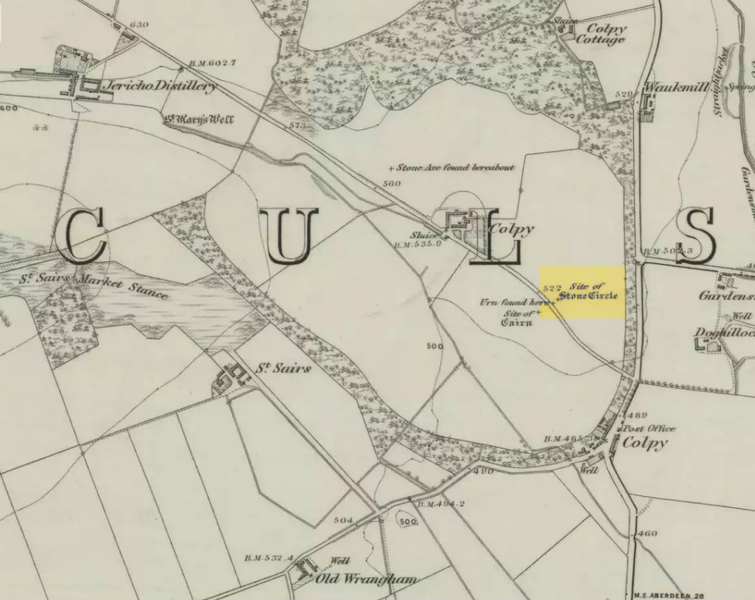
Colpy Circle site on 1868 map

Just like the stone circle a half-mile east at Kirkton of Culsalmond, nothing now remains of this megalithic ring.  It was first described very briefly by Rev. F. Ellis (1845) in the New Statistical Account as a “druidical temple”: one of two hereby, “on the farm of Colpie, although now almost obliterated. Several urns were dug up in making a road near one of them”—implying that one of them was a cairn circle or funerary monument of some kind.  This was subsequently affirmed on the early OS-map and then described in Fred Coles’ (1902) survey, where he wrote:

“Site of a stone circle, the road going to Jericho Distillery having been made through it, and, on the south side of this road, the site of a cairn. Within the possible diameter of the circle an urn was found.”

Folklore

A few hundred yards west of the circle an ancient fair used to be held, known as St Sair’s Fair, named after St Serf.  Although St Serf’s Day is July 1, early records show that the fair—held in a long field with the curious name of ‘St Sairs Market Stance’—was to be held on the Wednesday after the last Tuesday in June.  For a stone circle, this is too close to Midsummer to be a coincidence!  Early records show that the fair was granted in 1591 and subsequent years thereafter.

St Serf is a very peculiar mythological figure with quite shamanistic traits and tales around him.  In truth, many of these early saints were little more than lapsed shamans, utilising natural magick and medicine in the olde traditions, but which became grafted onto the incoming christian mythos.  The evidence for this is quite overwhelming!

References:

  1. Barnatt, John, Stone Circles of Britain – volume 2, BAR: Oxford 1989.
  2. Browne, G.F., On Some Antiquities in the Neighbourhood of Dunecht House, Aberdeenshire, Cambridge University Press 1921.
  3. Burl, Aubrey, “The Recumbent Stone Circles of North-East Scotland”, in Proceedings Society of Antiquaries, Scotland, volume 102, 1973.
  4. Burl, Aubrey, The Stone Circles of the British Isles, Yale University Press 1976.
  5. Burl, Aubrey, The Stone Circles of Britain, Ireland and Brittany, Yale University Press 2000.
  6. Coles, Fred, “Report on Stone Circles in Aberdeenshire (Inverurie, Eastern Parishes, and Insch Districts),” in Proceedings Society Antiquaries, Scotland, volume 36, 1902.
  7. Ellis, F., “Parish of Culsalmond,” in New Statistical Account of Scotland – volume 12: Aberdeen, William Blackwood: Edinburgh 1845.

© Paul Bennett, The Northern Antiquarian 

Kirkton of Culsalmond, Aberdeenshire

Stone Circle (destroyed): OS Grid Reference – NJ 6503 3293

Also Known as:

  1. Canmore ID 18243

Archaeology & History

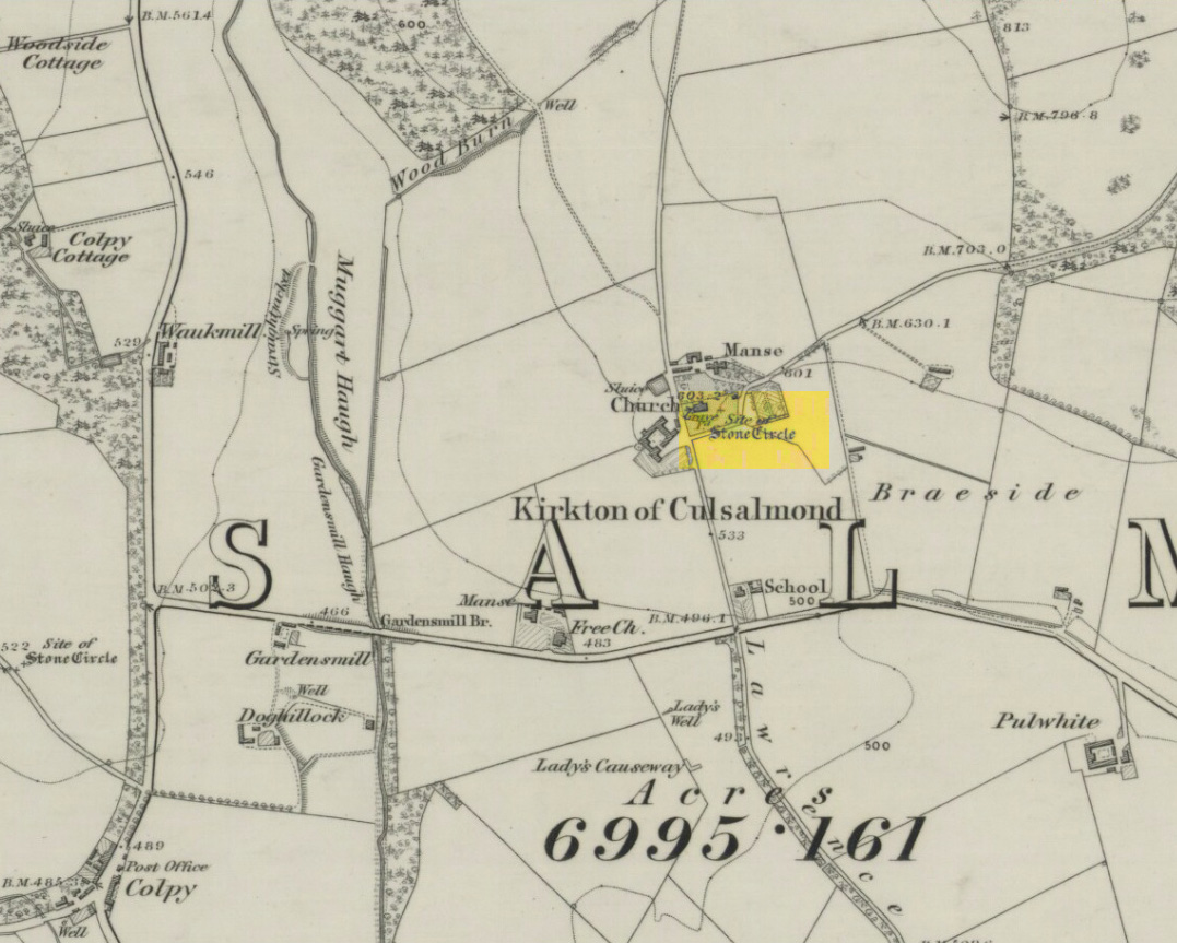
Site of the circle on 1873 map

After standing at the same spot for 3000 years or more, near the beginning of the 19th century this stone circle was destroyed by the self-righteous christian cult that was rampaging its way through cultures far and wide.  After all, they needed to rid the area of local traditions and “improve” the locals, whether they liked it or not!  Thankfully however, one of their creed—a reverend Ferdinand Ellis: minister of the parish for forty years—recorded its destruction in the New Statistical Account between 1834-45. Amongst a variety of important traditional monuments that once existed hereby,

“A Druidical place of worship anciently stood about the middle of the churchyard or burying ground.  It consisted of a circle of twelve upright large granite stones from Benochee, which were overturned when the first Christian temple was erected.  One of these was taken up in 1821 and now remains above ground, near the spot where it was taken up.  The other eleven are still underground.  This is proof that the first christian missionaries, in this country, erected their places of worship as near as possible to the holy hills of the heathens, that the people might be more easily persuaded to assemble there.”

Persuaded‘ being a very broad term indeed when it came to the land confiscation of indigenous folk…

The stone that Ellis said “was taken up in 1821 and now remains above ground” was gone when Fred Coles (1902) surveyed the site, but he told how an earlier antiquarian and writer for the Scottish Society of Antiquaries, J.G. Callander, lived nearby, and who was

“told by the aged sexton, Florance, that he many a time came across a great stone, when preparing graves, and that he had himself blasted these more than once.”

It seems that all trace of this single stone, and the rest of them, either still lay in the ground or were used for local building material.

When John Barnatt (1989) came to add this circle in his corpus, for some reason he postulated that

“the number of stones suggest it was a recumbent stone circle”,

…that is: a stone circle possessing one large stone in the ring that’s laid down with two standing stones either side.  However, there seems no real evidence to show that this was the case.

References:

  1. Barnatt, John, Stone Circles of Britain – volume 2, BAR: Oxford 1989.
  2. Browne, G.F., On Some Antiquities in the Neighbourhood of Dunecht House, Aberdeenshire, Cambridge University Press 1921.
  3. Burl, H.A.W., “The Recumbent Stone Circles of North-East Scotland“, in Proceedings Society of Antiquaries, Scotland, volume 102, 1973.
  4. Burl, H.A.W., The Stone Circles of the British Isles, Yale University Press 1976.
  5. Burl, H.A.W., The Stone Circles of Britain, Ireland and Brittany, Yale University Press 2000.
  6. Coles, Fred R., “Report on Stone Circles in Aberdeenshire (Inverurie, Eastern Parishes, and Insch Districts),” in Proceedings Society of Antiquaries, Scotland, volume 36, 1902.

© Paul Bennett, The Northern Antiquarian

Conwath Stone, Inverkeithny, Banffshire

Standing Stone (destroyed):  OS Grid Reference – NJ 629 452

Also Known as:

  1. Canmore ID 18332
  2. Charter Stone
  3. Charterstone
  4. Conway Stone

Archaeology & History

The standing stone that could once be seen here is long gone.  Its existence was reported in John Stuart’s (1854) short essay on stone circles of the region, in which he told:

“On the summit of the Hill of Balnoon, or rather on its neck towards the east, there was till lately a lofty upright stone called The Conwath or Conway Stone, and by some The Charter Stone.  It was surrounded by a slight ditch.”

A recumbent stone in the field immediately north may relate to Stuart’s old report.

Folklore

In the same article, Mr Stuart told some interesting folklore which strongly implies the stone to have had importance for women. He said:

“It has been said that funerals coming from the west end of the parish were accompanied to this stone by the females of the family, and that the funeral here rested for a time, and the females returned (the stone being in sight of the churchyard). My informant (the minister of the parish) states, that a cairn on the hill of Auchinhamper was used for a similar purpose by funerals coming from the east end of the parish. On visiting the stone, however, I found that the churchyard was not visible from that spot.”

References:

  1. Stuart, John, “Notices of Various Stone Circles in the Parishes of Cairney, Monymusk and Tough, Aberdeenshire; and of Inverkeithny, Banffshire,” in Proceedings of the Society of Antiquaries Scotland, volume 1, 1854.

© Paul Bennett, The Northern Antiquarian

Elphillock, Kildrummy, Aberdeenshire

Cairn:  OS Grid Reference – NJ 4907 1274

Also Known as:

  1. Elf Hillock

  2. Elphhillock

Archaeology & History

There is some confusion as to whether this mound of earth, barely four feet high but some 50 feet across, is actually prehistoric.  But the folklore has that common ring to it, found at olde sites from Cornwall to northern Scotland, speaking of old tombs and ancient ways…

Folklore

In modern times apparently, earthlights have been reported flitting about around this earthen ridge, but the old mound has older, more familiar tales spoken of it.  In Rev. Williams’ (1901) article on the folklore of Stirlingshire, he made a considerable detour to tell of some old faerie-lore he’d heard when he was younger, from the prehistoric tomb on the northern side of Elphillock, a few miles south of Kildrummy.  In talking with some of the local people about old beliefs, one local man told him:

“The fairies of my native parish made their abode in a round knoll, known as Elfhillock.  My friend, James Smith, now no more, was ploughman at Cairncoullie, in the neighbourhood.  Passing the hillock one evening, he heard the sound of music and dancing.  James drew near to the spot and saw the revels.  He waited and enjoyed himself for a short space and then returned to Cairncoullie and went to bed.  He found to his amazement that he had been away a year and a day!  Every field on the farm and the new ploughmen bore evidence to the fact; and Jamie believed till his dying day that he was a year older than he was aware of, and all because he had given heed to matters he had no business with.”

Not only were the little people said to live within this small tomb, but the hillock must also be cared for and never damaged.  Rev. Williams also narrated that the grandfather of the same local man told him that he had,

“pulled some heather from this elf hillock.  He was compelled by the women to replace it, otherwise he would have to encounter the wrath of the fairies.”

Thankfully the old hillock is still here, just off the roadside.  Not far from here are a number of other prehistoric sites with faerie and ghost-lore and mythological place-names, long since fallen into memories old…soon to be lost perhaps…

References:

  1. Williams, George, “Local Superstitions,” in Transactions of the Stirling Natural History and Archaeological Society, 1901.

© Paul Bennett, The Northern Antiquarian

Tobar na Cailleach, Keith, Banffshire

Sacred Well:  OS Grid Reference – NJ 42659 47528 

Also Known as:

  1. Cailleach Well 
  2. Tobar Chailleach 
  3. Well of the Cailleach

Folklore

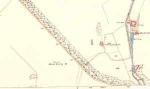
Cailleach Well on 1869 map

Described on the earliest OS-map of the region as Taber Chalaich, this great “well of the old woman, or hag” is found on the northern slopes of Cairds Hill, amidst increasingly dense woodland up the top of the stream which ebbs and flows in strength (depending on the weather).  A water source dedicated the prima mater Herself — i.e., the heathen pre-Celtic female creation deity par excellence — it was once of considerable repute locally as being a great curing well and was described by Ruth and Frank Morris (1981) as being,

“the scene of a pagan ceremony in which the Earth Mother in her old woman phase bathed at the well and returned as a young maiden.”

On the hill at the top we find remains of old tombs (mistakenly ascribed by Mr & Mrs Morris as ‘stone circles’), some of which may have had some mythic relationship with this legendary water source.  Further information and/or any photos of this little-known site would be hugely welcomed!

References:

  1. Morris, Ruth & Frank, Scottish Healing Wells, Alethea Press: Sandy 1982.

© Paul Bennett, The Northern Antiquarian


Kelpie’s Stane, Corgarff, Aberdeenshire

Legendary Rock:  OS Grid Reference – NJ 264 087

Also known as:

  1. Kelpie Stone

Folklore

The old Scottish folklorist, A.A. MacGregor, described this legendary rock, “by the Bridge of Luib, on the River Don,” in his classic Peat Fire Flame. (1937)  One of the numerous ‘holed stones,’ it was one of countless rocks in our isles imbued with animistic spirit essence, akin to similar rocks found in all of the other cultures in the world.  MacGregor told how,

“It happened that a man summoned to the death-bed of a relative came to this crossing-place just after torrential floods had carried away the bridge. When he was on the point of abandoning all hope of reaching the opposite bank, a tall man appeared from nowhere and volunteered to carry him across. The distracted homecomer accepted the assistance proffered. But, when he and his carrier reached mid-river, the latter reverted to the form of the river kelpie and endeavoured to drag him down to the river’s bed. The victim managed to escape. As he scrambled to the bank, the infuriated kelpie hurled after him the huge boulder that to this day goes by the name of the Kelpie’s Stane.”

But the stone was also known to possess healing and magickal properties, as evidenced from MacPherson’s (1929) chronicle, which told:

“Somewhere near Dinnet was the Kelpie Stone. Childless women passed through its 18 inch (46cm) hole to concieve. A noble lady performed the task to no avail; only when she repeated it in the same direction as the river flow did the charm work.”

Close by are several other intriguing place-names which may at some time have had some archaeo-mythic relevance to this legendary rock. On the hill above is the old Carn Lian; the water course nearby is the Allt na Ciste; but most intriguingly we find the Bog of the Old Woman, or the Moine Cailleach a half-mile to the east.

References:

  1. MacGregor, Alisdair Alpin, The Peat-Fire Flame, Ettrick Press: Edinburgh 1937.
  2. McPherson, Joseph M., Primitive Beliefs in the North-East of Scotland, Longmans, Green & Co: London 1929.

© Paul Bennett, The Northern Antiquarian


Haer Stanes, Llanbryde, Banffshire

Stone Circle (destroyed):  OS Grid Reference – NJ 2691 5985

Also Known as:

  1. Haerstanes
  2. Harestones

Archaeology & History

Haer Stanes on the 1871 map

This site had already passed into memory when the Ordnance Survey lads visited the area in 1870, but at least they included it on their early survey.  Fred Coles (1906) described this site in his essay on the megaliths of Banffshire, where once could be found perhaps five stone circles close to each other – but all are now gone!  Bloody disgraceful really.  When Coles explored here, although the site was still shown on maps, little could be seen of the place.

“On the farm,” he wrote, “we heard long-handed-down tradition of the Circle, and the site was, rather vaguely, pointed out.” But there was nothing there. He described one reference to the place written by a Mr James Morrison, who said, “We have remains of two so-called Druid Circles, and during the last half-century three others have been swept away. One of these was in horse-shoe form and was called the Haer Stanes.” The same writer later says, “These stones were unfortunately found to lie in the line of a road then formed (1830) and were ignominiously tumbled down the slope on which for ages they had rested, and buried in a gravel pit by the side of the road.”

References:

  1. Cole, Fred, ‘Report on Stone Circles Surveyed in the North-East of Scotland…’, in Proceedings of the Society of Antiquaries, Scotland, volume 40, Edinburgh 1906.

© Paul Bennett, The Northern Antiquarian


Battle Hill Dolmen, Huntly, Aberdeenshire

Cairn (destroyed):  OS Grid Reference – NJ 542 401

Archaeology & History

In a short article, ‘Dolmens in Scotland’, written by Dr H.O. Forbes in the esteemed Antiquity journal of June 1929, Dr Forbes reported the former existence of a dolmen-like monument that stood,

“some 70 years ago…at the north or northwestern extremity of Battle Hill which looks down on the town of Huntly on the River Bogie in Aberdeenshire.  In walking from Drumblade to the town, about 3 miles off, one usually took a short cut over Battle Hill.  This bypath diverged from the turnpike road leading north to Banff and led to the top of Battle Hil (400ft), close past the edge of the wood, a few yards within which stood this monument.  It was a typical dolmen, of which I retain a perfectly clear recollection, with its large granite capstone supported by three massive, rudely shaped pillars.  On the aspect towards the bypath, there were some blocks of stone on the ground which may have constituted a fourth pillar or the ruins of a dromos, otherwise the dolmen was in excellent preservation.  It stood about 6 to 7 feet high above the ground level, for I remember it took some climbing for me as a small boy to get on top.”

Folklore

Dr Forbes also described several legends attached to this long forgotten old tomb.  He told “that it was a ruined druid’s altar; that the stones were dropped down through a hole in the devil’s apron when on his way to Knock Hill to deposit the cloven-stone there (a large glacial erratic); and that it is the tomb of a great warrior.”  A story that we find at a number of prehistoric tombs in both Britain and abroad.  At some nearby tumuli, legend told that they stood on the site of a great battle.

References:

  1. Forbes, H.O., ‘Dolmens in Scotland,’ in Antiquity journal, volume 3, June 1929.

  2. Grinsell, Leslie, Folklore of Prehistoric Sites in Britain, David & Charles: Newton Abbot 1976.

© Paul Bennett, The Northern Antiquarian