Potlock Cursus, Willington, Derbyshire

Cursus (destroyed):  OS Grid Reference – SK 314 287 to SK 321 289

Also known as:

  1. Findern Cursus
  2. Findern-Willington Cursus
  3. Potlocks Cursus
  4. Twyford Cursus

Archaeology & History

Destroyed by the usual mixture of intensive farming practices and the self-righteous advance of industrialism, this cursus of many names was discovered thanks to aerial survey photographs taken in the early 1960s.  Found only 6½ miles west of the Aston Cursus and constructed on level ground on the north side of the River Trent next to B5009 road between Twyford village and Willington.  I think the site was first described by J.K. St. Joseph (1966) in his notes on air reconnaissance finds, in which he described the site,

“So far the parallel ditches, some 220ft apart, defining the cursus have been identified on an east to west alignment across three fields for a length of some 1800ft.  This may well be only fraction of the total length of the monument, which probably extended westwards towards the new power station at Willington.  Three ring-ditches, one lying within the cursus, and two to the north, as well as a rectangular enclosure, have also been recorded.”

There was probably more to be discovered here, he thought.  And so the following year the first dig into one section of the site was made, and again in 1969.  A synopsis of this and subsequent excavation work have been reported on the PastScape website which tells:

“The cursus has been traced for a distance of at least 1560 metres, lying near the edge of the flood-plain of the Trent. Excavations in 1994-5 in advance of work on a bypass recovered Peterborough Ware sherds close to the bottom of the southern cursus ditch. Charred organic remains were also present, from which radiocarbon dates are to be sought. The excavations also uncovered a causeway between 10.5 and 19 metres in length through the northern ditch. Within this causeway were a cluster of short linear features and a post hole, all presumably evidence for controlling access into the monument. Another break in the northern ditch was shown to have been created to accommodate the course of a stream, which still runs through it. The 1994-5 excavations also confirmed that the 1969 excavations had in fact found a series of natural features which were mistakenly interpreted as representing the cursus ditches… At the south-western limit of the cursus cropmarks the southern ditch appears to have been recut and possibly reused at a later stage as a double ditched trackway…”

References:

  1. St. Joseph, J.K., “Air Reconnaissance: Recent Result, 6,” in Antiquity journal, volume 40, no.157, March 1966.
  2. Wheeler, Hazel, “The Findern Cursus,” in Derbyshire Archaeological Journal, volume 90, 1970.

© Paul Bennett, The Northern Antiquarian

Stanwell Cursus, Heathrow, Surrey

Cursus (destroyed):  OS Grid Reference – TQ 0545 7431 to TQ 0448 7782

Also Known as:

  1. Heathrow Cursus

Archaeology & History

Running roughly north-to-south, this cursus was 2¼ miles long (3600 metres) and comprised of two linear sections from a field in Stanwell up through the western side of Heathrow Airport averaging, curiously, just 24 yards (22m) across.  Of course nothing of it can be seen today as the airport and surrounding industrial crap has destroyed it.  The cursus had a lengthy internal bank along its length. During excavation work done at the Perry Oaks Sludge Works section in Hillingdon, archaeologists found evidence for a short avenue of posts, about 110 feet long, apparently constructed prior to the cutting of the cursus’ ditches, following the same direction/alignment of the subsequent monument.  In Roy Loveday’s (2006) survey of cursus monuments he said this of Heathrow’s cursus:

“This site, striking across land so flat that it has been selected  for Heathrow Airport, extends for some 4km, crosses two rivers and stops by a stream — originally perhaps a more major river.  So straight and apparently narrow is it (20m) that it was originally taken to be a Roman road.  Early excavation seemed to support the idea: vestigal remains areas of gravel between the ditches were scored by shallow gullies resembling cart ruts.  Later excavation, however, demonstrated that the ditches of a Late Bronze Age field system cut across it and several scarps of Peterborough Ware (i.e., pottery – PB) were recovered from its ditches.  Evidence also emerged of a short (50m) ragged, double row of posts, removed before the ditches were dug on the same alignment.  That this was a bank barrow was hinted at by the Charlecote test and by reduction in the depth of field ditches as they crossed the central area.”

Confirmation that an earthen bank of some kind running near the middle of the cursus was confirmed by analysis of early Ministry of Defence aerial photographs.  For those who would like a more detailed description on this site, I refer you to the excellent paper by o’ Connell. (1990)

…to be continued…

References:

  1. Barclay, Alistair, et al, Lines in the Landscape, Oxford Archaeological Unit 2003.
  2. Loveday, Roy, Inscribed Across the Landscape, Tempus: Stroud 2006.
  3. o’ Connell, M., “The Heathrow-Stanwell Cursus,” in Current Archaeology, 9, 1986.
  4. o’ Connell, M., “Excavations during 1979-1985 of a Multi-Period Site at Stanwell,” in Surrey Archaeological Collections, 80, 1990.

© Paul Bennett, The Northern Antiquarian

Salford Cross Cup-Marks, Oxfordshire

Cup-Marked Stone:  OS Grid Reference – SP 28644 28058

Getting Here

Pretty simple this one.  From Chipping Norton, head west on the A44 for a coupla miles till you hit the lovely Salford village.  The church stands out, so head for it and, as you walk towards the building, watch for the small stone cross in front of you.

Archaeology & History

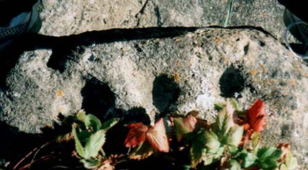
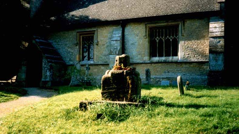
Salford Cross cup-markings

This is curious.  Very curious!  We might expect to find cup-markings occasionally on some of the cross-bases or other early christian monuments in northern England and Scotland, but to find them in the heart of a small Oxfordshire village where the tradition of cup-marked stones is unknown, was something of a surprise when Tom Wilson and I (1999) found it, to say the least!  But this is what we’re looking at here.

Salford Cross remains

On the remains of an old medieval cross, whose broken shaft has seen better days,  as the photo shows — and as a personal viewing shows even clearer — there are 3 simple cup-markings etched on one side of the cross-base in Salford churchyard.   The cups certainly aint natural, but then also they don’t have the archaic looks of the prehistoric carvings from Yorkshire to Scotland.  It would be good if we had a more extensive history of the cross monument itself, perhaps saying precisely where the stones which make it up came from, but local records tell us nothing it seems.  If we could ascertain that parts of it were made up of some remains taken from some local prehistoric ‘pagan’ tomb (and a number of tombs have been found in and around this area), then some sense could be thrown upon its position here.  But until we can ascertain more about the history of the cross, the three clear cup-markings on the cross-base remain somewhat of a mystery.

Folklore

Lovers of ley lore will be intrigued to find this carved cross-base is on a very accurate ley linking the King Stone, Rollright stone circle, Little Rollright church (where a standing stone can be found in the walling just before it), the Salford Cross and the site of another cross on the hill outside the village.

References:

  1. Bennett, Paul & Wilson, Tom, The Old Stones of Rollright and District, Cockley: London 1999.

© Paul Bennett, The Northern Antiquarian

Maxey Cursus, Cambridgeshire

Cursus (destroyed):  OS Grid Reference – TF 125 078

Archaeology & History

Much of this site has unfortunately been completely destroyed.  Thought by Colin Burgess (2001) to be one of the earliest cursus monuments,  it was Paul Devereux (1989) who gave the clearest early description of this site,* telling:

“This site is to be found…between the village of Maxey and the River Welland, south of Market Deeping. When discovered by aerial photography the cursus was already partially destroyed… The northwest segment ‘starts’ almost on the banks of the Welland and goes southeast on a straight course to an obliterated point where a change of alignment occurred, and the cursus continues in a different direction. The total known length is 1930 yards (1.77km), and the width averages 190 feet (58 metres). The ditches themselves display subtly different orientations, but are in straight sections. The investigations of F. Pryor suggests that the northwest length of the cursus was constructed long after the southeast portion, when the latter’s ditches had become silted up (banks do not seem to have been present). The southernmost ditch of the southeastern section bisects two circular sites. Site A is particularly interesting. It occurs just east of the…change in direction, or junction of the two cursuses if such was the case.”

And such is the case, as recent discoveries have found. But before this was known for sure, Devereux wrote, that “a segment of cursus ditch emerges from this vaguely henge-like site, 450 feet in diameter, in the direction of the nearby church” of St. Peter.

The “henge-like site” described here has been defined by Oswald, Dyer and Barber (2001) as one of the enigmatic ’causewayed enclosure’ monuments – out of which emerges the other seperate alignment, the Etton Cursus, heading southeast.

References:

  1. Burgess, Colin, The Age of Stonehenge, Phoenix: London 2001.
  2. Loveday, Colin, Inscribed Across the Landscape, Tempus: Stroud 2006.
  3. Oswald, A., Dyer, C. & Barber, M., The Creation of Monuments, EH: Swindon 2001.
  4. Pennick, N. & Devereux. P., Lines on the Landscape, Hale: London 1989.
  5. Pryor, Francis, Britain BC, Harper-Collins: London 2003.

* The OS-reference for this site is of the northwestern end of the cursus. The southeastern terminal is at TF139063.

© Paul BennettThe Northern Antiquarian


Black Hill Long Cairn, Low Bradley, Skipton, North Yorkshire

Cairn:  OS Grid Reference – SE 0092 4756

Also Known as:

  1. Black Hill Long Barrow
  2. Bradley Moor Long Barrow
  3. Bradley Moor Long Cairn
  4. King’s Cairn

Getting Here

Follow the same directions for getting to the Black Hill Round Cairn.  It’s less than 100 yards away – you can’t miss it!

Archaeology & History

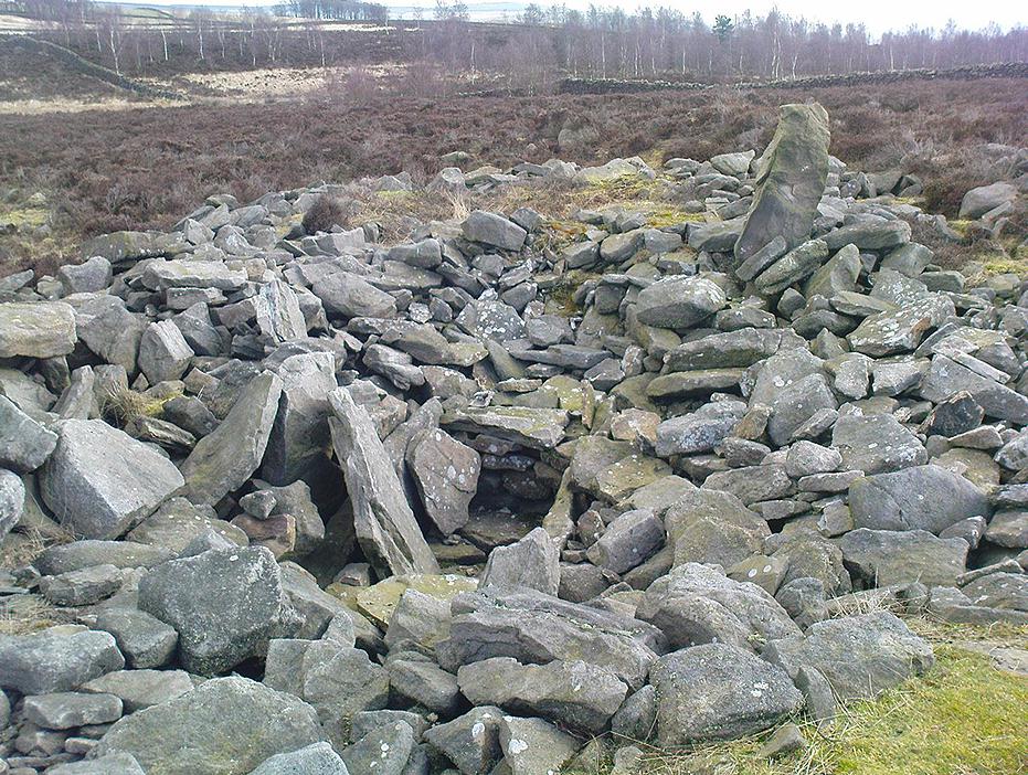
This is a superb archaeological site — and it’s bloody huge! It’s big and it’s long and it sticks out a bit – which is pretty unique in this part of the Pennines, as most other giant cairns tend to be of the large round variety.  Although the site was originally defined by Arthur Raistrick (1931) as a long barrow, J.J. Keighley (1981) told how, “it was found to be a round cairn imposed on a long cairn.”  And it’s an old one aswell…

Near the SE end of the giant cairn
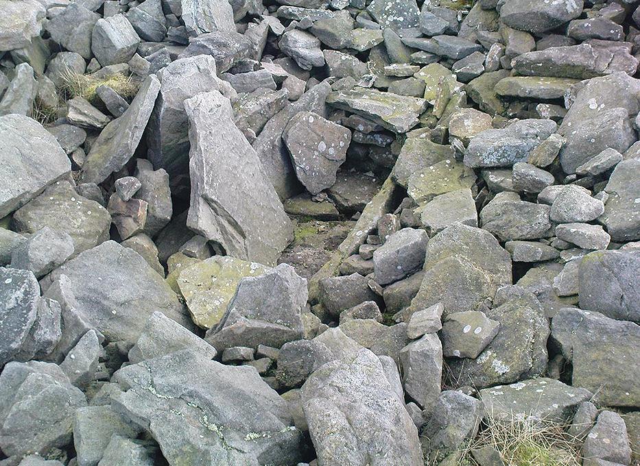
Close-up of the main cist

More than 220 feet long and 80 feet in diameter at its widest southeastern end, as we walk along the length of the cairn to its northwestern edge, its main body averages (only!) 45 feet in diameter.  Made up of tens of thousands of rocks and reported by Butterfield (1939) to have had an upright stone along its major axis, the “height varies from 4-8ft, but the cairn has been much despoiled and disturbed,” said Cowling in 1946. He also told how,

“Excavation revealed that almost in the centre of the mound were the remains of a cist made of roughly dressed stone flags and dry walling, covered by a large stone. Under a stone slab, laid on the floor of the cist, were fragments of (burnt and unburnt) bone and a small flint chipping.”

This is a very impressive site and deserving of more modern analysis. The alignment of the tomb, SE-NW, was of obvious importance to the builders, believed to be late-neolithic in character.  The tomb aligns to two large hills in the far distance in the Forest of Bowland which we were unable to identity for certain.  If anyone knows their names, please let us know!

Folklore

The older folk of Bradley village below here, tell of the danger of disturbing this old tomb. In a tale well-known to folklorists, it was said that when the first people went up to open this tomb for the very first time, it was a lovely day. But despite being warned, as the archaeologists began their dig, a great storm of thunder, lightning and hailstones erupted from a previously peaceful sky and disturbed them that much that they took off and left the old tomb alone. (I must check this up in the archaeo-records to see if owt’s mentioned about it.)

References:

  1. Ashbee, Paul, The Earthen Long Barrow in Britain, Geo Books: Norwick 1984.
  2. Butterfield, A., ‘Structural Details of a Long Barrow on Black Hill, Bradley Moor,’ in YAJ 34, 1939.
  3. Cowling, E.T., Rombald’s Way, William Walker: Otley 1946.
  4. Keighley, J.J., ‘The Prehistoric Period,’ in Faull & Moorhouse’s West Yorkshire: An Archaeological Survey, I, WYMCC: Wakefield 1981.
  5. Raistrick, Arthur, ‘Prehistoric Burials at Waddington and Bradley,’ in YAJ 30, 1931.

© Paul Bennett, The Northern Antiquarian

Long Bredy Cursus, Dorset

Cursus:  OS Grid Reference – SY 5718 9115

Also Known as:

  1. Martin’s Down Cursus

Archaeology & History

Although very little of this cursus can be discerned on the ground, the scar of the monument is clearly visible from the air (as the GoogleEarth image shows, below).  In 1989 the great archaeo-geomancer, Paul Devereux, visited the place hoping to see the monument, but said that no remains were visible at ground level, although noted how its western end is marked by the Long Bredy burial mound.  Sitting amidst a mass of later neolithic and Bronze Age ceremonial remains, this old cursus aligned SE to NW.  Devereux told how,

“the extended axis of the cursus…to the east, goes through a group of round barrows on the crest of a ridge on Black Down about a mile away. If diagrammatic material published by an investigating archaeologist is accurate, the alignment continues to the Nine Stones circle…immediately by the roadside a short distance west of Winterbourne Abbas.”

The monument has been measured at be at least 130 yards (100m) long and 28 yards in diameter at its greatest point.

References:

  1. Pennick, Nigel & Devereux, Paul, Lines on the Landscape, Robert Hale: London 1989.

© Paul Bennett, The Northern Antiquarian

Lechlade Cursus, Gloucestershire

Cursus:  OS Grid Reference – SP 2125 0046

Archaeology & History

In Pennick & Devereux’s (1989) early assessment of our enigmatic cursus monuments, he wrote the following brief notes of this particular site:

“The crop marks of another fragmentary cursus were found in Gloucestershire immediately north of Lechlade, to the west of the River Leach. The crop marks aligned northwest-southeast for 174 yards (160 metres) and were 160 feet (50 metres) wide. Only the square northwest end is known. Excavations were carried out in 1965 in advance of gravel workings. No finds were reported, but two out of three cuttings revealed a post-hole on the inside of the ditch.”

References:

  1. Pennick, Nigel & Devereux, Paul, Lines on the Landscape, Hale: London 1989.

© Paul BennettThe Northern Antiquarian


Hitching Stone, Keighley Moor, West Yorkshire

Legendary Rock:  OS Grid Reference – SD 98665 41698

Getting Here

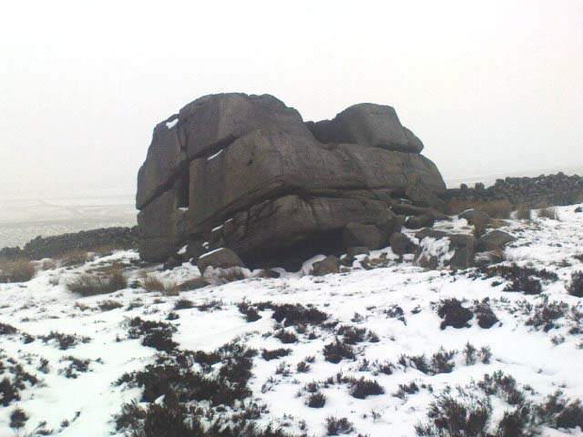
Hitching Stone through fog and snow
Hitching Stone through fog & snow

The easiest way to get here is via Cowling – though you can approach the place via moorland roads from Sutton-in-Craven, Oakworth and Keighley, but Cowling’s the closest place (so we’ll take it from there).  Turn east off the A6068 up Old Lane at the Ickornshaw side of town and go up the steep and winding road until you hit the moors.  Just as the road levels out with walling on either side of the road, there’s some rough ground to your left.  You can park here.  You’ll blatantly see our Hitching Stone on the moorland a few hundred yards above you on the other side of the road.  Walk up the usually boggy footpath straight to it!

Archaeology & History

For me, this is a superb place! Each time I come here the place becomes even more and more attractive — it’s like it’s calling me with greater strength with each visit.  But that aside…

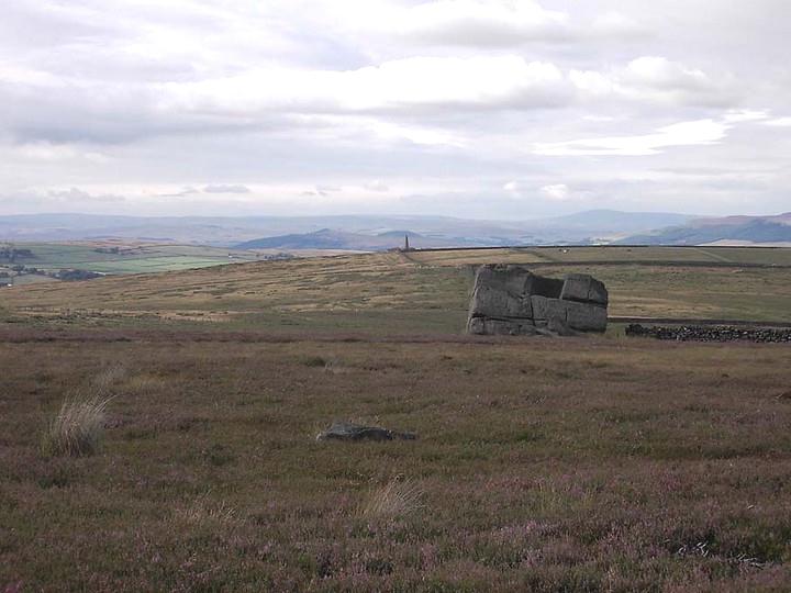
Supposedly the largest single boulder in Yorkshire, it possesses several legends, aligns with the sacred Pendle Hill in Lancashire, is an omphalos (centre of the universe spot) and has other good points too! My first visit here was near the end of the Great Drought of 1995.  All of the streams and springs had dried up on the moors but, on the very top of this huge rock, measuring at least 8 feet by 4 feet across (and 3 feet deep) was a large pool of water, not unlike a bath, in which a couple of you could easily bathe (and do more besides, if the fancy takes you!).  It was surreal!  Water-boatmen and other insects were living in this curious pool on top of the rock.  Yet all other water supplies for miles around had long since dried-up.  It didn’t really seem to make sense.

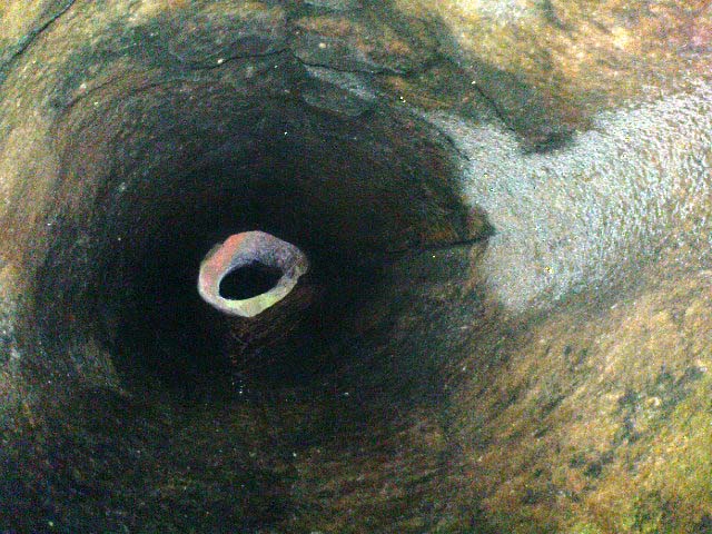
Crystalline tunnel in the Hitching Stone

On the west-facing side of the boulder, about 8 feet up, is a curious deep recess known as the Druid’s or Priest’s Chair, into which initiates were sat (facing Pendle Hill, down which it seems the equinox sun “rolls”) and is believed, said Harry Speight, “to have some connection with Druidical worship, to which tradition assigns a place on these moors.” If you climb up and inside the Priest’s Chair section you’ll notice a curious “tunnel” that runs down through the boulder, about 12 feet long, emerging near the northern base of the rock and out onto the moor itself.  This curious tunnel through the rock is due to the softer rock of a fossilised tree (Lepidodendron) crumbling away — and not, as Will Keighley (1858) believed, “the mould or matrix of a great fish.” When we visited the stone the other day in the snow, we noticed how the inner surface of this tunnel was shimmering throughout its length as if coated in a beautiful crystalline lattice (you can sort-of make this out in the image here, where the numerous bright spots on the photo are where the rock was lit up). Twas gorgeous!

The Hitching Stone, looking north

The boulder lies at the meeting of five boundaries, and was the starting point for horse-racing event until the end of the 19th century.  A short distance away “are two smaller stones, the one on the east called ‘Kidstone’, the other ‘Navaxstone’, which stands at the terminus of the race-course.” (Keighley 1858)  Lammas fairs were also held here, though were stopped in 1870.

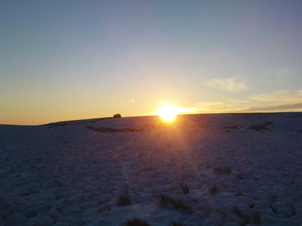
The cup-marked Winter Hill Stone a few hundred yards to the northeast, which I previously thought aligned with this site around winter solstice, but which happens to be a few degrees of arc off-line, would have indicated a very early mythic relationship, but this thought may now have to be put to bed.  I’ve not checked whether the winter solstice alignment shown in the photo below (with the Hitching Stone being shown on the near-horizon as the sun rose on winter solstice, 2010, from Winter Hill Stone) would have been closer in neolithic times or not.  Summat to check out sometime in the future maybe…

This aside, there is little doubt that this was an important sacred site to our ancestors.

Folklore

Winter Solstice sunrise, 2010 (from Winter Hill Stone)

Legend has it that the Hitching Stone used to sit on Ilkley Moor. But it was outside the rocky house of a great witch who, fed up by the constant intrusion the boulder made to her life, tried all sorts of ways to move it, but without success. So one day, using magick, she stuck her wand (or broomstick) into the very rock itself and threw it several miles from one side of the valley to the other until it landed where it still sits, on Keighley Moor.

A variation on the same tale tells that she pushed it up the hill from the Aire valley bottom. The “hole” running through the stone is supposed to be where our old witch shoved her broomstick!

References:

  1. Bennett, Paul, The Old Stones of Elmet, Capall Bann: Milverton 2001.
  2. Gray, Johnnie, Through Airedale form Goole to Malham, G.F. Sewell: Bradford 1891.
  3. Keighley, William, Keighley, Past and Present, R. Aked: Keighley 1858.
  4. Wood, Eric, Cowling: A Moorland Parish, Cowling Local History Society 1980.

© Paul Bennett, The Northern Antiquarian