Fraggle Rock, Hawksworth Moor, West Yorkshire

Cup-and-Ring Stone:  OS Grid Reference — SE 15094 43502

Getting Here

Fraggle Rock, Reva Hill

Probably the easiest (direction wise) is if you’re coming from Dick Hudson’s public house on the southern road surrounding Rombalds Moor. From the pub, head left (east) along Otley Road (passing Weecher reservoir) for 1.9 miles (3.1km) until you reach Reva reservoir where a track leads you to the waters.  A small parking spot is on the left-side of the road. From here, go through the gate and along the footpath across the field for nearly 300 yards to the next gate; go through here and walk to your right for about 60 yards where uyou’ll reach a small straight dyke (keep your eyes peeled!) running NW (to your left): walk along here for nearly 200 yards until it hits another shallow dyke bearing right; follow this dead straight for 35 yards after which it changes direction, but you need to keep walking straight on forward for another 60 yards or so.  Look around!

Archaeology & History

Early photo of the carving
First photo of the carving

This carving is one in a cluster of previously unrecorded petroglyphs, uncovered in the summer of 2011 during a Northern Antiquarian bimble on the northern edge of Rombald’s Moor.  The carvings were found as a bi-product of uncovering a previously undiscovered cairn circle, close to the Twelve Apostles stone circle.  In assessing and exploring the newly-found circle, it was noticed that a small opening in the near horizon highlighted a rise in the landscape barely a mile away.  This ‘opening’ in the land was not visible if you walked 25 yards either side of the cairn circle – but was very notable at the circle itself.

“We need to have a look at that site,” I said.  “It’s position looks to have been relevant to this circle.” (or words to that effect) And a couple of weeks later we met up and walked to the place in question.

Fraggle Rock carving, looking west
Fraggle Rock carving, looking south

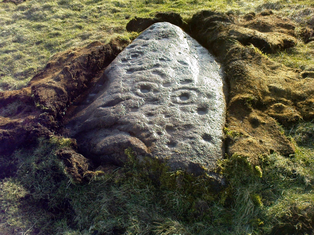
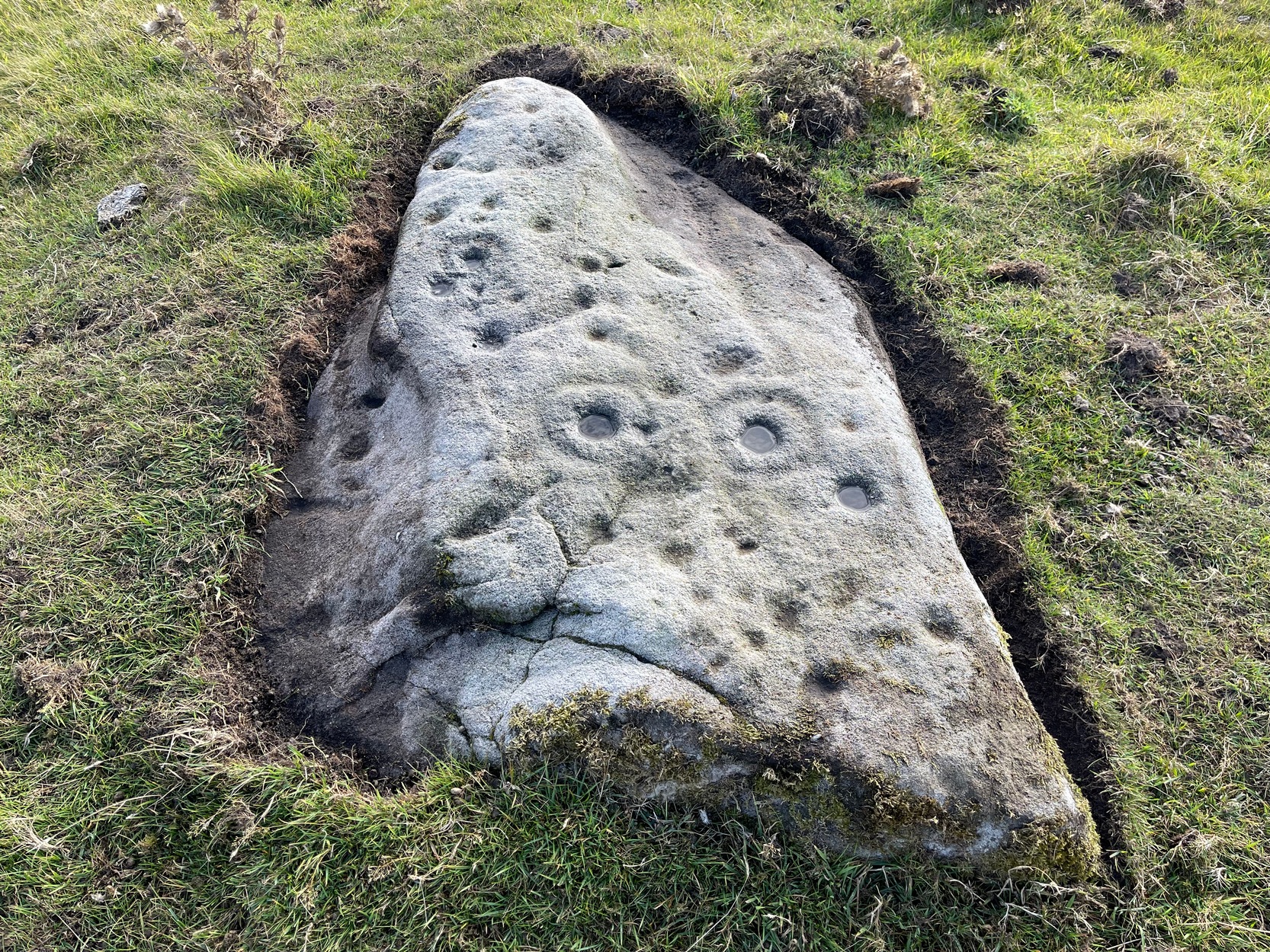
Within five minutes we came across a couple of previously unrecorded cup-marked stones, of simple design, right in line with the cairn circle.  As we walked around this spot, then headed back in the direction of the circle, a cluster of small stones were noticed on the slope.  One had what looked like a single cup-marking near its edge, but the rest of the rock was completely covered in vegetation.  Paul Hornby and Michala Potts had, by now, already found several other previously unrecorded cup-marked stones close by; but as I carefully rolled back the vegetation at the edge of this particular rock, cups-and-rings and carved lines seemed to be covering most of its surface.  It was a good one!

Face on the Fraggle Rock

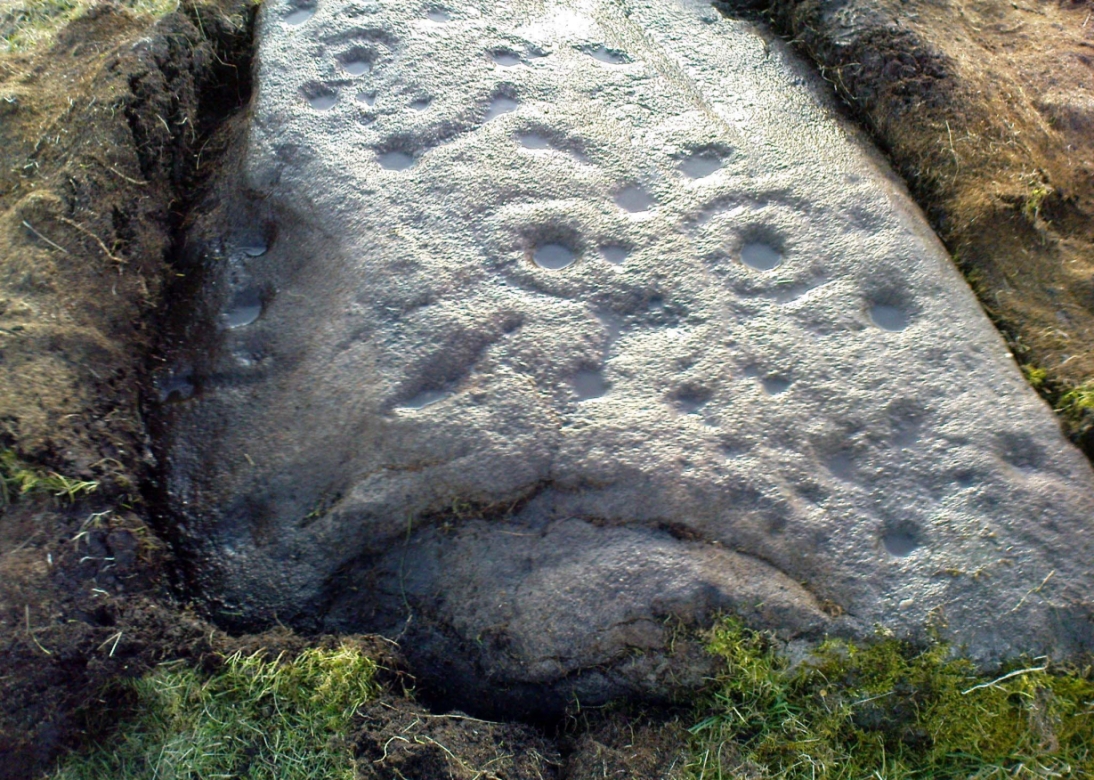
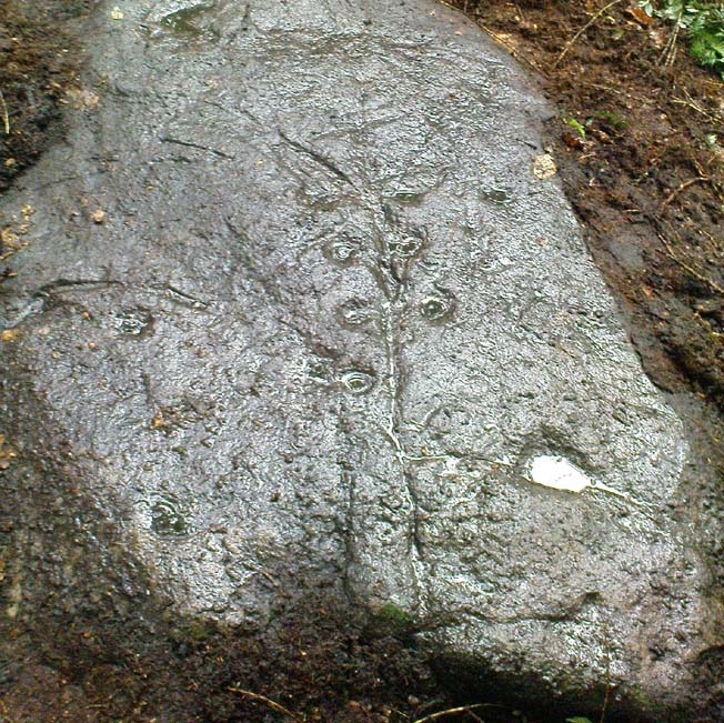
We called it the Fraggle Rock after noticing that when you look at the stone from one end, the two main cup-and-rings are likes two large eyes carved above a large natural down-turning ‘mouth’ feature, similar to some of the creatures’ faces on the muppets or the similar kid’s TV show, Fraggle Rock! (sad aren’t we!?)  The photo here shows you what we mean.

The primary design consists of at least 3 cup-and-rings, 2 partial cup-and-rings, 28 cups and several carved lines along which some cup-markings are linked to others.  The most notable of the carved lines is the longest (barely visible in the photos), running from a single cup-mark at the southernmost rounded end of the stone, almost straight and parallel with a natural ridge or dip along the rock, until it meets the largest of the cup-and-rings (one of the eyes on the Fraggle’s face!).  Don’t ask me why, but for some reason this long faint line seemed the most perplexing element of the carving.

Eastern edge, with cups at ground level
Eastern edge with low cups
Cup-marks on rock edge

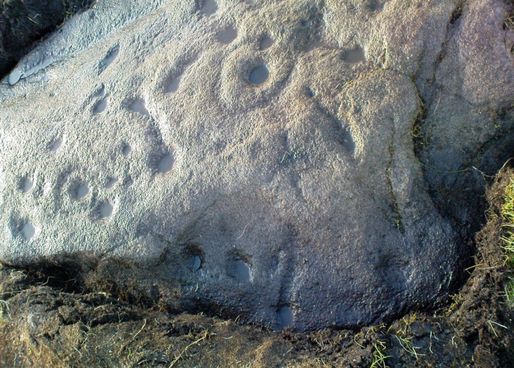
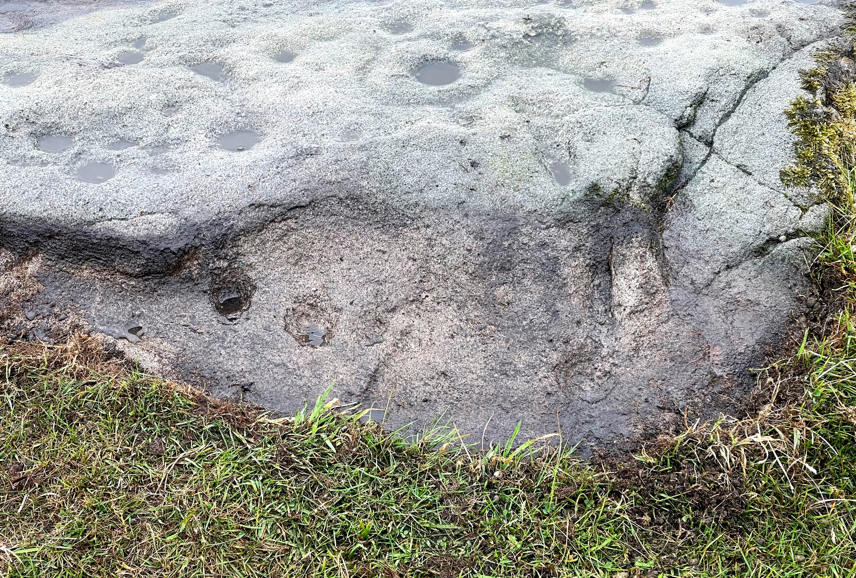
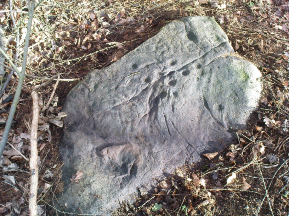
Most of the design is carved on the upper face of the stone, but a small part of the rock dips into the ground on its eastern side and a small group of cups and a single carved line, in a very good state of preservation, are etched right at the edge of the stone.  Unusual.  Another faint cup-and-ring is less than 100 yards west; and a fascinating cup-and-lines stone, with at least four long carved ridges running like hair from the top of the stone into the Earth, is a short distance to the north.  A number of others are in this and adjacent fields.

References:

  1. Jack, Jim, “Old Fraggle Rock is Found on Burley Moor,” in Ilkley Gazette, March 4, 2013.

© Paul Bennett, The Northern Antiquarian 


Tree Stone, Ilkley, West Yorkshire

Cup-Marked Stone:  OS Grid-Reference – SE 1043 4702  

Archaeology & History

One of the first photos, just as the mud had been cleared

This carved stone was rediscovered by Michala Potts on the rainy afternoon of August 26, 2011, on a Northern Antiquarian excursion to explore some of the cup-and-rings on Ilkley Moor.  The entire stone was totally covered in soil and leaves, and Michala spent some considerable time carefully clearing the dead vegetation to unveil the carvings beneath.

Close-up of cups & scars

This carving has at least 12 cup-marks on its slightly inclined surface, with several artificial carved lines and some that are obviously geophysical in origin. (we really could do with a geologist with a cup-and-ring fetish to accompany us on some of our outings!)  But the main feature of this carving — as the photos here illustrate — appears to be the natural crack that runs up through the middle of the stone, either side of which have been etched a number of cup-markings attached by small lines or ‘branches’, giving the distinct impression of a tree.  Whether this was a deliberate artistic feature (a tree), or just another Rorscharch response to non-linear systems on our behalf (more probable), we’ll never know.  On the moors northeast of here on the other side of the Wharfe valley, the Tree of Life Stone acquired a similar association due to its design; but this Ilkley design, sadly, aint quite as good as the one on Askwith Moor.

Tree Stone, showing modern industrial scars

There are some puzzles on this stone aswell.  Other lines scar the rock which are definitely man-made, but they are of a different nature and age.  The marks have been scarred by more modern metal tools, or were caused by heavy metal machinery that have rested on the rock at some time in the not-too-distant past.  You can see the curved deep scratches in the photo here to the right.  It seems likely that when the modern houses were built straight across and above here, this cup-marking was damaged by the workers — although they didn’t know it was here as the stone had not been catalogued by the Ilkley archaeologists.  But there’s also another peculiar feature on this stone.  Someone a century or two ago also carved other fainter features into the stone, seemingly lettering, on the northeast edge of the rock.  They can be seen faintly on the second photo, above.

© Paul BennettThe Northern Antiquarian 


Robin Hood’s Stone, Allerton, Liverpool, Lancashire

Standing Stone:  OS Grid Reference – SJ 3997 8638

Archaeology & History

Robin Hood's Stone (after Alfred Watkins)
Robin Hood’s Stone (after Alfred Watkins)

Similar in size and appearance to one of the cup-marked Tuilyies standing stones in Fife, Scotland, it was our old ley-hunter, Alfred Watkins, who described this stone in his Ley Hunter’s Manual (1927), along with giving us the old photograph taken by one of his mates here, which also showed the cup-and-ring carvings near the base of the stone. Are they still visible? (I’ve not been here, hence mi ignorance!) Watkins thought the cup-markings at the bottom represented some of the local leys—but unfortunately they don’t.

Folklore

Legend says that the deep grooves running down the stone were made by men sharpening arrow-heads on it (like a whetstone).  There was also the usual christian Victorian fable that the stone was used by the druids and that the grooves on the stone were where the blood of their human sacrifices was channelled to the ground!  The stone was also said to have some relationship with the nearby Calder Stones (which seems probable).

References:

  1. Cowell, Ron, The Calderstones – A Prehistoric Tomb in Liverpool, Merseyside Archaeological Trust 1984.
  2. Watkins, Alfred, The Ley Hunter’s Manual, London 1927.

Links:

  1. Mike Royden’s Local History Pages – Robin Hood’s Stone

© Paul Bennett, The Northern Antiquarian


Sweet Willy Well, Wrose, Shipley, West Yorkshire

Healing Well: OS Grid Reference – SE 16561 36440

Also Known as:

  1. Lin Well
  2. Silver Stream
  3. Sugar Stream

Getting Here

Sweet Willy Well, Eccleshill

Whether you’re coming here from Wrose or Eccleshill, go along Wrose Road and turn down Livingstone Road at the traffic lights. Down here, when the road splits, head to your right until you meet with those stupid road-block marks (where you can only get one car through). Just here, walk down the slope and path on your right, and before you hit the bottom of the slope, walk down the small valley for about 20 yards until you see the small stream appear from beneath some overgrown man-made stone lintels. That’s it!

Archaeology & History

When I was a kid I used to play down this tiny valley when the waters here still had small fish swimming away (we used to call them ‘tiddlers’). The fish seem to have gone, but there are still waterboatmen on the surface, indicating that we still have fresh water here – and on my most recent visit, I cautiously tasted the waters and found them OK (the prevalence of broken bottles and beer cans from locals doesn’t inspire you to drink here though).

Initially located on the local boundary line between Eccleshill and Wrose, the waters used to be found running into a trough about 100 yards further up the small valley, but this has been lost and housing now covers its original site.  You can see how the stream has cut the valley further upstream, but now it bubbles up from beneath the rocks shown in the photo.  Bradford historian Robert Allen (1927) described the site in his survey as originally being between North Spring and South Spring Wood.

Although the name Sweet Willy Well remains a mystery, one of its other titles — the Lin Well — relates to the presence of linnets that used to be found in great numbers here.  The ‘Sugar Stream’ name is one we knew it as locally as children, due to the once sweet taste of the waters.  It is likely to have had medicinal properties, but these have been forgotten.  No archaeological survey has ever been done of this site.

References:

  1. Allen, Robert C. (ed.), The History Of Bolton In Bradford-Dale; with Notes on Bradford, Eccleshill, Idle, Undercliffe, Feather Bros: Bradford 1927.

© Paul Bennett, The Northern Antiquarian


Northcliffe Woods, Shipley, West Yorkshire

Cup-and-Ring Stone: OS Grid Reference – SE 13642 36608

Getting Here

Shipley FieldsCR518
Cup-and-ring stone at Northcliffe

Takes a bit of finding this one, and isn’t that impressive, so is probably only of value to the real enthusiasts. From Shipley, head up to Northcliffe and take the walk into the woods. Walk along the valley bottom, past the old train line at the bottom of the valley, and keep going for a few hundred yards until you meet with the small pond or damn on your left. Somehow cross over the stream and walk up the overgrown hill right above the pond. You’ll notice a single rock, on the right-hand side of the tiny stream running down the slope you’re walking up, just on the top of the ridge near the tree-line about 20 yard or so before the golf course. That’s it!

Archaeology & History

NorthcliffCR dr
Drawing of the Northcliff carving

This little-know cup-and-ring stone, seemingly in isolation just over the northern edge of the golf-course about 20 yards into the woods at the top of the ridge, cannot be contextualized with any adjacent monuments as the area has been badly damaged by the industrialists, as usual, with both quarrying and the golf course – much like the damage done at Pennythorn Hill, above Baildon.

This rock has what seems to be at least five cup-markings: two quite prominent, the others smaller and more faded.  Earlier surveys by the likes of Sidney Jackson (1962) saw another two cups on the stone, but these seem to be natural.  A curious large ring runs around the cup near the top of the stone, but this is pretty faint nowadays.  One of the cups along the edge of the stone also looks like it may have had an arc carved around the top of it, but this needs exploring at different times of day and in different lighting conditions to verify or deny this.

References:

  1. Jackson, Sidney, “Cup-Marked Rock, Northcliff Wood,” in Cartwright Hall Archaeology Group Bulletin, 7:6, 1962.

© Paul Bennett, The Northern Antiquarian


Bowling Green Stone, Shipley, West Yorkshire

Cup-Marked Stone:  OS Grid Reference – SE 14505 37525

Also Known as:

  1. Carving no.8 (Boughey & Vickerman)
  2. Shipley Old Hall Carving

Getting Here

Carved stone beside the path

From Shipley town centre open market, take the Kirkgate road up to Saltaire, past the old town hall. On the other side of the road take the little path into the Bowling Club, in the trees (if you hit the church you’ve gone too far).  Once standing in front of the bowling green itself, you need to walk along the left-side path. Two-thirds of the way down, now laid in the ivy-covered area below the old quarry face, you’ll find what you’re looking for.

Archaeology & History

I remember first seeking out this carving when I was still at school and wondering how the hell it got here – and believed it to be a fallen standing stone at the time!  It seems that the stone was cut and readied for use as a gatepost instead, at some time long ago.

Close-up showing cups & lines
In its previous locale

The curious cup-marked stone has travelled about a bit, somehow.  Formerly at the edge of a field in the grounds of Bradford Grammar School 3 miles away (at SE 1523 3583), the fella was then built into the wall of the now-demolished Shipley Old Hall, before reaching its present resting place at the edge of the bowling green.  Consisting of around 16 cup-markings with carved lines seeming to link them here and there, it was first mentioned by the late great Sydney Jackson (1955) in an early edition of the Bradford Archaeology Journal.  The carving was recently included in the Boughey & Vickerman (2003) survey, where they described it as,

“Medium-sized fairly smooth grit rock with coarse line down top, probably natural, evidence of quarrying on edge.  Sixteen or seventeen cups, one with a groove out has a deeper cut within it and twelve of the others are linked in pairs by short grooves.  This has been interpreted as feathering for quarrying, but the grooves are across the line of likely split, rather than along it.”

And for those of you who live nearby: if you check this out, see if you can locate an earthfast boulder near here which I recall having a cluster of distinct cup-marks running on top of the rock along one side. I couldn’t find it when I looked a short while ago, it’s not in the archaeology survey lists, and it remains lost—in the heart of Shipley no less!

References:

  1. Boughey, Keith & Vickerman, E.A., Prehistoric Rock Art of the West Riding, WYAS: Wakefield 2003.
  2. Jackson, Sydney, “Cup-Marked Boulder, Shipley Old Hall,” in Bradford Cartwright Hall Archaeology Group Bulletin, 1:10, 1955.

© Paul Bennett, The Northern Antiquarian


Buck Woods Carving (03), Thackley, Bradford, West Yorkshire

Cup-and-Ring Stone:  OS Grid Reference – SE 17456 39162

Getting Here

A mossy cup-and-ring

Follow the same directions as if you’re visiting the largest and most ornate of the Buck Woods carvings. From here, about 10 yards ahead of you, roughly north, you’ll see another stone, less than half-size of Buck Woods 1, moss-covered and not rising too much out of the Earth.  It’s not difficult to find once you’ve located the largest of the Buck Woods stones.

Archaeology & History

A cup-and-half-ring

Another of the small cluster of little-known prehistoric carved stones in this woodland on the edge of Bradford, not in the Boughey & Vickerman (2003) survey.  This however is possessed of a cup-and-half-ring, with other seemingly carved ingredients fusing onto natural aspects of the rock.  The design is found on the highest part of the stone; and whilst the main cup is easy to make out, the encircling half-ring is slightly troublesome.

…and from another angle

There are two distinct lines running down one side of the rock, both seemingly natural, but they may have been added to—it’s difficult to say with any certainty.  Certainly the one closest to the cup-and-half-ring has the carved line etched to meet the natural geological feature, as you can just make out in the photos here.  There also seems to be other carved features surrounding the central design, with other marks round the main cup, almost suggesting that a complete ring was being made, but never accomplished.  It’s an odd one.  If I’d have stripped the moss from the stone I could have seen the design in greater detail, but I’ve gotta bittova soft spot for mosses and lichens, so left it alone!

© Paul Bennett, The Northern Antiquarian


Buck Woods Carving (04), Thackley, Bradford, West Yorkshire

Cup-Marked Stone:  OS Grid Reference – SE 17418 39163

Getting Here

It’s the moss-covered stone, centre-right

Follow the same directions as if you’re visiting the largest and most ornate of the Buck Woods carvings. From here, walk 10 yards to the Buck Woods 3 carving, then about the same distance forward again until you reach the low lines of (what looks like) Iron Age walling running roughly east-west through the trees.  Walk 10-20 yards east along the walling until a gap or entrance appears – and on the other side where the walling starts again, check the 2nd or 3rd rock along, beneath the mosses.

Archaeology & History

More simple cup-marks

There are no previous references to this small cup-marked stone, whose cups are on the topmost surface of the stone in this ancient stretch of walling (into which some vandal has recently carved his name, ‘Hunt’). It’s another one for the purists amongst you though, as we only have 2 or 3 cupmarks here, as the photos show – with just one which I can say is a certainty.  Curiously the other two look, for all the world, as if they’re mollusc cups!—but considering you’re about 50 miles from the sea, this seems a little unlikely.  Worth having a look at when you’re checking the other four carvings close by.

© Paul Bennett, The Northern Antiquarian


Buck Woods Carving (02), Thackley, Bradford, West Yorkshire

Cup-Marked Stone:  OS Grid Reference – SE 17473 39152

Getting Here

Buck Woods cup-marks

Follow the same directions as if you’re visiting the largest and most ornate of the Buck Woods carvings. Once there, notice the green field on the other side of the wall less than 50 yards away. Walk towards the wall, about 20 yards from the Buck Woods 1 carving, keeping your eyes peeled for a flat mossy stone.  You’ll find it!

Archaeology & History

Close-up of the cups

A nice simple, almost cute cup-marked stone—not included in the Boughey & Vickerman (2003) survey—with three simple cups running almost in a straight line from the middle of this long stone to its outward, eastern edge.  One of the good features of this and its associated carvings is the setting amidst which it’s found. We tend to associate these carvings with open moorland, where many now live, but when they were first carved they were surrounded by woodland and much more: important ingredients relevant to understanding the nature of these curious carvings…

© Paul Bennett, The Northern Antiquarian


Woofa Bank Enclosure, Burley Moor, West Yorkshire

Enclosure:  OS Grid Reference – SE 13890 45516

Getting Here

Aerial view showing enclosure outline

From Ilkley, take the Cowpasture Road up past Cow & Calf rocks, the hotel and along the moorside.  A few hundred yards further, just before the next farm-building on your right, walk up the Rushy Beck path to the top. Crossing the stream at the top, now walk  diagonally south-ish into the heather for some 200 yards, a short distance before the hillside begins to rise up again onto the next ridge.  Remains of this ‘enclosure’ is all around you!

Archaeology & History

When the normal moorland vegetation covers this prehistoric site, you’d barely know there was anything here apart from various rocky rises and undulations in the ground and perhaps, if you were seeking out old stuff, what would seem to be lines of stone walls bending away onto the moor.  But when the heaths have been burnt back, a whole new vista unfolds itself!  You see before you a fantastic, well-preserved, unexcavated prehistoric enclosure, whose origins are probably neolithic, but whose history and use stretched through the Bronze Age and into the Iron Age—and it’s not alone!  East, west and south of this particular enclosure, other prehistoric walled structures are found stretching all across the landscape hereby, structurally similar and also used over very long periods in prehistory.  For antiquarians and historians alike, this is a truly impressive place indeed.  In all honesty, the description I give here does not do the place justice!

Northwestern section of enclosure walling

Things like ‘settlements’ and ‘enclosures’ are traditionally relegated by purist archaeologists to be little more than domestic or utilitarian sites: places where our ancestors kept cattle; or were used for defensive purposes; or lived for long periods of the year.  Of course, these simple ideas are effective and true at some places; but here at Woofa Bank—in this particular enclosure—something more than just domestic activity was enacted, and over the period of many centuries by the look of things.  We surmise this by the incidence of at least fifteen cup-and-ring stones being found within the enclosure itself; and at its very centre is a small standing stone, not previously recorded, that has perhaps five petroglyphs around it.  The presence of such a large cluster of cup-and-ring stones close together within the enclosure would seem to suggest ritual activity.

Carved rock & central stone
Close-up of, dancing anthropomorphic figure?

One of the carvings at the centre of the enclosure (listed in the Boughey & Vickerman survey as Carving 372) has been suggested to represent a dancing human figure (the image here shows the anthropomorphic element), which it may well be.  The incidence of this central stone and its surrounding petroglyphs has important magico-religious implications, relating it as a site used for creation myth narratives and repetitions (transpersonal explorations at this site may prove worthwhile).  The wider extended enclosure with more petroglyphs contained inside it, suggest that additional ritual performances were enacted here; these may have had something to do with the cluster of prehistoric tombs scattered on the moorland plain 100 yards to the west, but we might never know.

Easternmost standing stone

It seems that the walled enclosure itself was constructed around the earlier cup-and-ring stones, probably many centuries later—but we need excavations here to give us more precise details.  Much of the enclosure walling itself has the hallmarks of being late Bronze Age to Iron Age, whilst we know that prehistoric rock art can date back into the neolithic period; and from this period Eric Cowling (1946) reported that, at Woofa Bank, “at the western end of the ridge,” just above this enclosure, a neolithic flint site existed.

Cowling’s 1946 plan

Cowling (1946) himself was one of very few archaeologists to even mention this impressive site, in a section exploring the “Iron Age” sites along Green Crag Slack at the eastern end of Ilkley Moor.  He wrote:

“At the other end of the site under the shadow of Woofa Bank and near the source of the Rushy Beck, is another D-shaped enclosure apparently unfinished.  The plan is of a circle with a flattened side and does not exceed twenty-four yards across in any direction.  Here the enclosing wall shows five or six courses at the lower end side and a simple entrance to the west.”

Western entrance to enclosure
Stone marking eastern entrance

Though Cowling’s measurements are way out!  The enclosure itself is much larger than he describes.  For the most part, three-quarters of it give the impression of it being a large oval shape, but the design and outline of the walling changes on its southeastern side and kinks inward, in an arc, to eventually meet the walling in the middle eastern section.  Its entire circumference measures approximately 220 yards all the way round; it is 65 yards across east-west; and about 61 yards north-south.  The average height of the main walling is between 2-3 feet tall, and is made up of many large rocks, some of them positioned upright as standing stones, all packed together with earth and countless thousands of smaller stones.  The walling itself is between 2-3 yards wide in many places and has two main entrances: one near the middle of the western wall and the other almost opposite to the east.  The eastern entrance is marked by a standing stone between 3-4 feet tall.  No gaps are visible at all on the northern curved section of the enclosure.  On the overgrown southern edges, not all of the walling is visible and much of it is overgrown.  On the whole it’s still very much as Cowling found it, with the arc of walling in this part of the enclosure difficult to make out clearly.  There is also another line of walling that runs off to the east, beyond the main enclosure itself.

Carved rock in western wall

The clearer, more visible western line of walling, running south of the entrance on that side, has a large singular cup-and-ring stone laid right along its axis (carving 366 in the Boughey & Vickerman [2003] survey), a short distance before the walling changes direction east-west and runs along the bottom of the slope.

Folklore

Tradition tells that the tribal people from this site were involved in a battle with the Romans along this moorland plain.

References:

  1. Bennett, Paul, The Old Stones of Elmet, Capall Bann: Chieveley 2001.
  2. Boughey, Keith & Vickerman, E.A., Prehistoric Rock Art of the West Riding, WYAS: Wakefield 2003.
  3. Cowling, Eric T., Rombald’s Way, William Walker: Otley 1946.
  4. Eliade, Mircea, Images and Symbols, Harvill Press: London 1961.
  5. Hedges, John (ed.), The Carved Rocks on Rombalds Moor, WYMCC: Wakefield 1986.
  6. Size, Nicholas, The Haunted Moor, William Walker: Otley 1934.

© Paul Bennett, The Northern Antiquarian