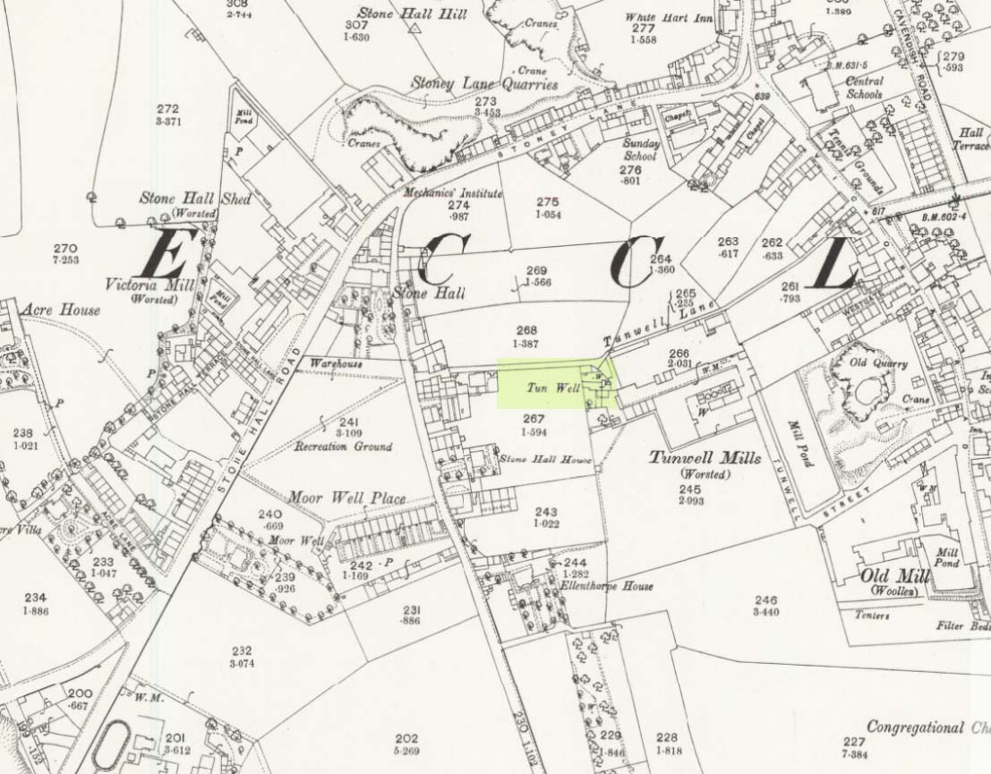
First mentioned in local history accounts from 1618—as the Tunwells—it was highlighted on the first OS-map of Eccleshill in 1851. Located on the aptly-named Tunwell Lane, it was a deep well covered by a large flat slab of stone, at the back-end the old Victorian mill. The stone was put there to prevent children falling into it. Some old locals thought the name of the place derived from a ‘tun’, or hundred, meaning it to be a hundred feet deep; although as A.H. Smith (1961) tells, tun could equally relate it to be one of Eccleshill’s town wells, of which there were several. It used to be one of the principal drinking supplies for the village and was said to rarely run dry. In William Ranger’s (1854) survey, he told this to be one of the sites to which local people relied in times of drought, where the land-owner allowed local folk to collect their supplies.
Folklore
The old cobbled Tunwell Lane was long ago supposed to be the haunt of a phantom black dog: a visionary precursor of death and Underworld guardian. Its spirit came and went into the deep well. I remember hearing tales of this when I was a young lad, as the old women who worked in the adjacent mills spoke of it. The ghost of a so-called ‘white lady’ was also said to walk along Tunwell Lane.
In more recent times, Val Shepherd (2002) included this in her short survey of wells in the area as being on “an alignment” with Eccleshill’s Moor Well and Holy Well. She thought “it may be part of a ley line”, but her alignment is inaccurate and doesn’t hit the spots.
References:
Crapp, H.C. & Whitehead, Thomas, History of the Congregational Church at Eccleshill, Watmoughs: Idle 1938.
Ranger, William, Report to the General Board of Health on a Preliminary Inquiry into the Sewerage, Drainage, and Supply of Water, and the Sanitary Condition of the Inhabitants of the Township of Eccleshill, George Eyre: London 1854.
Shepherd, Val, Holy Wells of West Yorkshire and the Dales, Lepus: Bradford 2002.
Smith, A.H., The Place-Names of the West Riding of Yorkshire – volume 3, Cambridge University Press 1961.
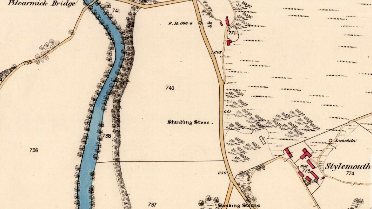
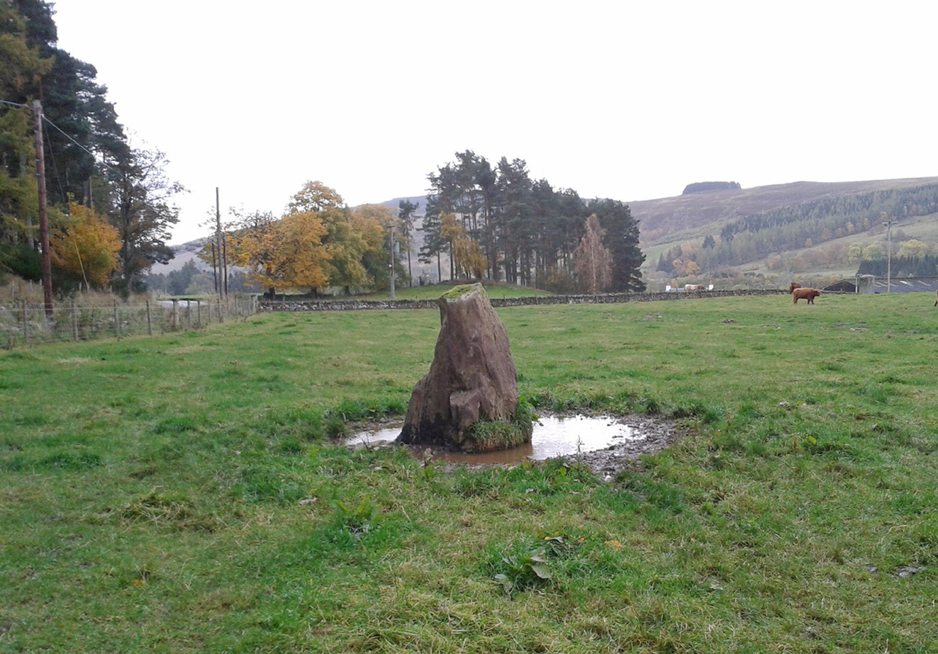
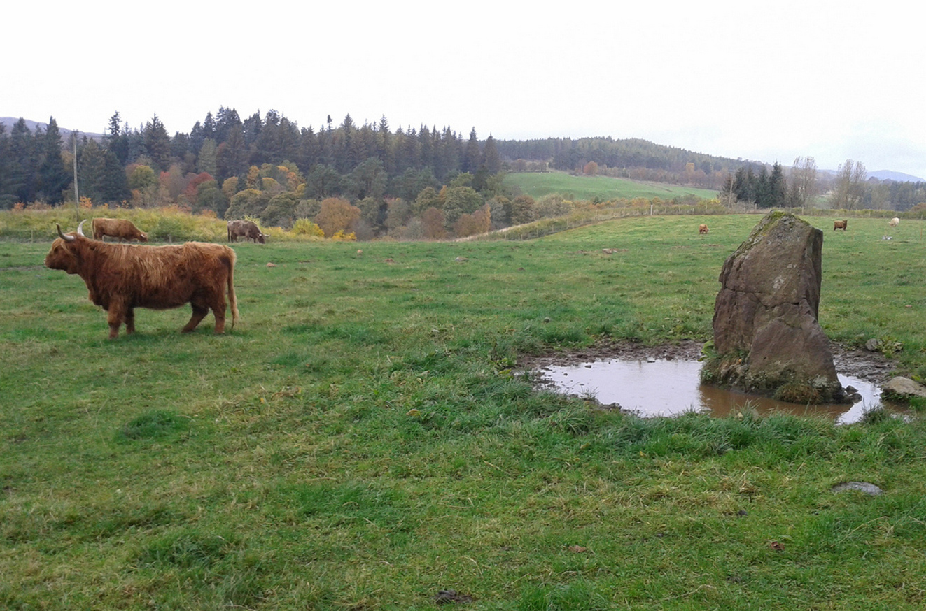
Take the A924 road north of Blairgowrie, between Pitlochry and Bridge of Cally and, about 4.6 miles (7.5km) along, roughly halfway between Ballintuim and Kirkmichael, in the field by the roadside immediately west, you’ll see this conspicuous upright stone standing all alone – unless the cattle are meandering slowly around it! Y’ can’t really miss it.
Archaeology & History
This single monolith that stands today as a cattle rubbing post, may at one time in its distant past have been related to the present pair of standing stones hiding in the small remain of trees 148 yards (135.5m) to the south; although neither Aubrey Burl (1993) nor Alexander Thom (1990) ascribe the stone such an association in their relative tomes on aligned stone rows.
When the great standing stone lover Fred Coles (1908) came here, he was as reliable as ever in his subsequent exposition of the place – and despite getting his measurements slightly out he told us, almost liltingly, like an antiquarian Uncle Monty stroking his megaliths, that
Balnabroich stone, looking SThe old stone, looking NW
“At a point almost 176 yards due north of (the) two stones is a tallish and unshapely monolith standing but a few yards west of the main road. Its most notable feature is the extreme irregularity of its shape. If any proof were needed to show how uncritical were the people who raised such stones, how totally devoid of any regard for symmetry or neatness of contour in the monoliths they set up, surely the ground-plan of this block of rent and riven quartz-veined whinstone, fissured and uncouth in all its parts, would supply it.
“The contour here shown was measured by laying down an irregular rhomboidal figure, and from each of its sides measuring by offsets to the depths 0f the curves which are so prominent on the north, the northwest and the southeast sides. The ground-plan this obtained shows that, taken between their prominent angles, the four sides measure almost exactly 3 feet each, and the main long axis of the stone which lies due east and west and measures 4 feet 6 inches. The monolith stands 5 feet 8 inches above the ground and…appear to have been unconnected with circles, so far at least as it was possible to glean any information.”
Royal Commission on the Ancient & Historical Monuments of Scotland, North-East Perth: An Archaeological Landscape, HMSO: Edinburgh 1990.
Acknowledgements:Huge thanks for use of the Ordnance Survey map in this site profile, reproduced with the kind permission of the National Library of Scotland.
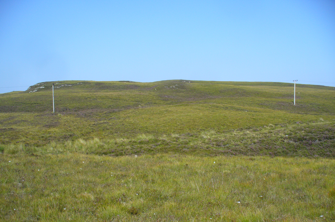
Take the A836 road between Bettyhill and Tongue and, roughly halfway between the two villages, a few hundred yards west of the turning to Borgie, park up at the roadside. Cross the road and through the gate, follow the waters of Allt Loch Tuirslighe for 100 yards and then walk uphill onto the moors. You’re damn close!
Archaeology & History
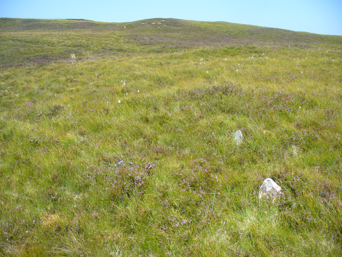
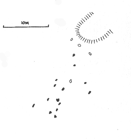
This megalithic stone row was uncovered in the late 1970s – which is no surprise to be honest. It is a very low parallel row of small upright stones, which Freer & Myatt (1982) initially found to consist of two rows of standing stones, twelve in all. When we visited the site a few days ago, I could find only ten of them that could appreciably be termed authentic – and that was stretching it a bit!
Several of the low stones
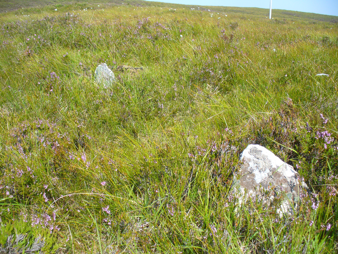
Close-up of the small stones
Of the two stone rows presently visible, the easterly one is easier to see and consists of seven small stones, running almost in a dead straight line NNE. A few yards west we find the second stone row, in which I could only discern three tangible contenders, also running NNE, but slightly fanning outwards and away further north. When standing in the middle of the two rows, they align to a small natural rocky outcrop on the near-horizon 100 yards away, upon which Paul Hornby recently discovered 3 or 4 faint cup-markings. If we turn 180 degrees and look in the opposite direction, the alignment of stones points to the highest peak in the far distance.
Myatt’s 1988 survey
Gourlay’s 1996 survey
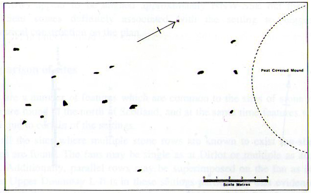
All of the stones are small and difficult to see upon initial exploration. The highest of them stands no more than 1½ feet tall, with their average less than 1 foot. One of the stones in the eastern row is covered completely by vegetation. However, in earlier assessments of this site, quite a few other stones were visible. Its brief history and appearance was described in Leslie Myatt’s (1988) survey of such monuments in this remote region, where he told:
“This very ruinous setting of stone rows was fist recorded by the Archaeology Division of the Ordnance Survey… Peat cutting has taken place in the area and undoubtedly a number of stones have been removed from the site.
“(The illustration) shows the result of a survey carried out by the author showing a total of only 16 stones not more than 20cm above the surface. Because of the small number of stones remaining, it has not been possible to superimpose a geometric construction on the site. The ground slopes upwards to the north-northeast, at which end of the setting is a low peat-covered mound about 10m in diameter. It has no distinctive features, although it does not appear to be natural…”
The site is described in Alexander Thom’s (1990) major survey, but sadly he didn’t turn his direct attention here, so we still have no accurate geometric or astronomical assessment. A few years later Aubrey Burl (1993) gave us details of the larger initial size of the complex and told us that at
“Borgie, near Torrisdale Bay on the north coast of Sutherland, perhaps an early site, has three or four lines with the suspicion of a fifth. The rows narrow from their base 20ft (6.1m) across to 18ft 8in (5.7m) over a distance of 59ft (18m), a contraction as they worm uphill towards a peat-covered mound of hardly a quarter of an inch in a foot (0.6: 31cm).”
The small peat-covered mound which the stone rows lead up to was suggested by Robert Gourlay (1996) as “perhaps a small cairn.”
References:
Burl, Aubrey, From Carnac to Callanish, Yale University Press 1993.
Freer, R. & Myatt, L.J., “The Multiple Stone Rows of Caithness and Sutherland,” in Caithness Field Club Bulletin, 3:3, April 1982.
Gourley, Robert, Sutherland: An Archaeological Guide, Birlinn: Edinburgh 1996.
Myatt, Leslie, “The Stone Rows of Northern Scotland,” in Ruggles 1988.
Ruggles, Clive, Records in Stone: Papers in Memory of Alexander Thom, Cambridge University Press 1988.
Thom, A., Thom, A.S. & Burl, Aubrey, Stone Rows and Standing Stones – 2 volumes, BAR: Oxford 1990.
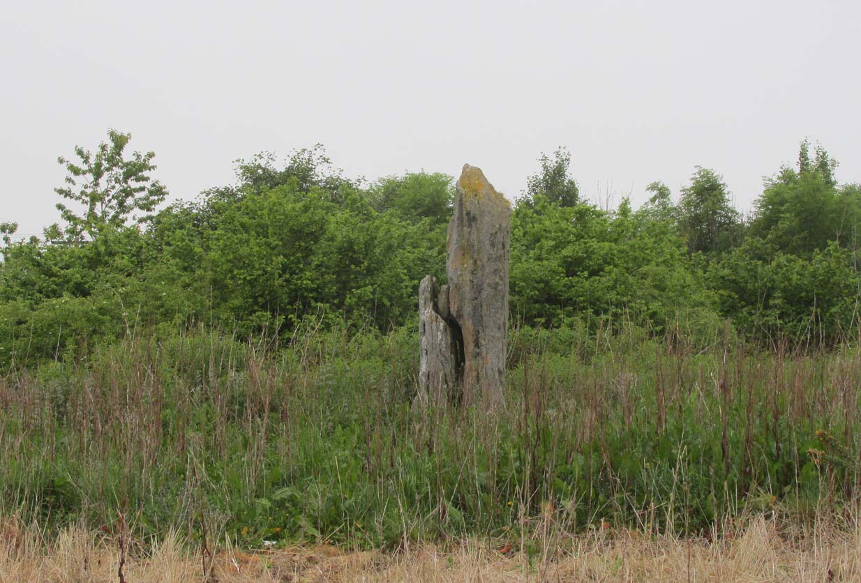
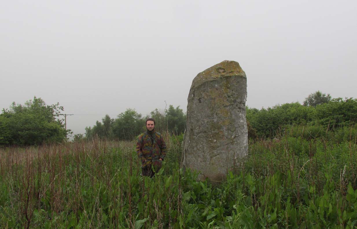
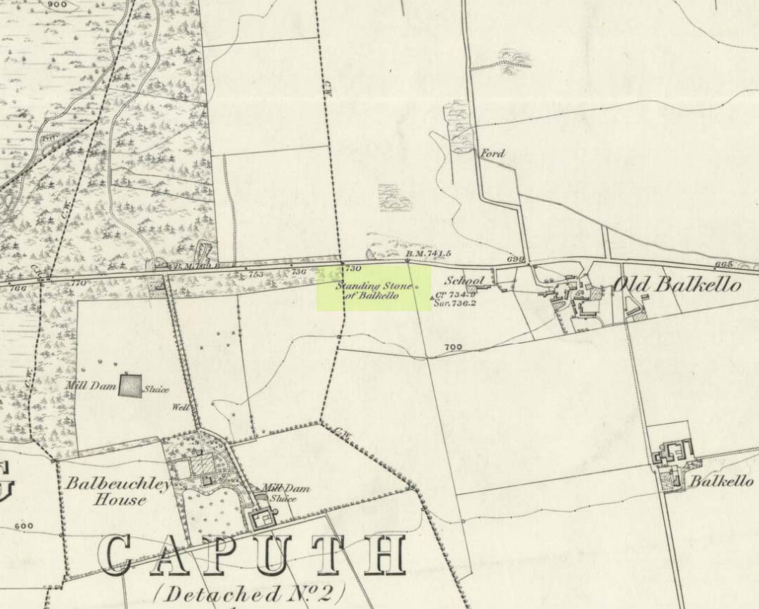
From the little village of Kirkton of Auchterhouse, take the winding road uphill east as if you’re heading to Tealing. About 1⅓ mile along, where the road has straightened out, keep your eyes peeled on your right (to the south) where—if the vegetation isn’t too high—you’ll see a tall upright stone in the field. You’ll have to walk along the roadside until you find a gate into the overgrown field. Good luck!
Archaeology & History
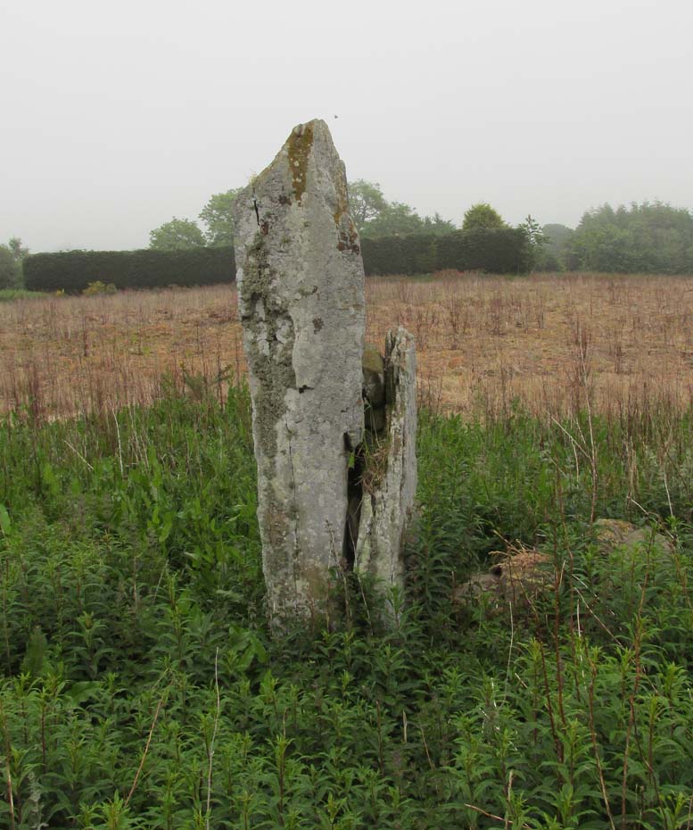
Not to be confused with the legendary Martin’s Stone of Balkello ⅘-mile to the southeast, this is a little-known standing stone hiding above a mass of boscage ‘pon a quiet ridge that fades focus away from the world. It’s a bittova giant, all but forgotten it seems, and with little history to speak of in literary terms at least. When we visited the place a short while ago, summer nettles and willowherbs obstructed our initial contact—but we got to the fella eventually.
This dood lives & sleeps at the stone!
Looking east
Standing more than nine feet high and about five feet across, it’s quite a slender monolith that has seen better days. Its southern face is crumbling away and a large section of it is close to splitting off completely (surely a case for Historic Scotland to fix?). As you can see in the photos, upper portions of the stone have fallen into the widening crack that promises to fell the stone at some time in the not-too-distant future. Let’s get it sorted —before it collapses!
Balkello Stone on 1865 map
It was highlighted on the first OS-map in 1865 as the Standing Stone of Balkello, although without antiquated lettering. But unless there is excellent reason to suggest this was erected in recent times (it wasn’t), its ‘prehistoric’ status needs activating—cos it’s surely prehistoric! We all thought so anyhoo… It’s well worth checking out when you’re in the area!
Folklore
When the Ordnance Survey lads first visited the site in 1861, local people informed them that the stone was said to be,
“in Connection with some others in the Parish (and) are supposed to have (been) used to point out the Roads as they were then, merely beaten paths.”
Alfred Watkins students take note!
Acknowledgements: Huge thanks as always to Paul Hornby, Nina Harris & Frank Mercer for their assistance in our visit here.
Holy Well (destroyed): OS Grid Reference – TQ 3096 8106
Archaeology & History
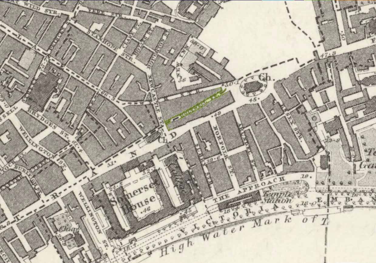
Close to the long-lost Strand Cross and long-lost Strand Maypole, in bygone centuries was also to be found a holy well of great repute, dedicated by early christians to the sea-faring St. Clement. Its presence was recorded in the ‘Holywell Street’ name at far the eastern end of The Strand but, like its compatriot monuments, it too is long-lost… Thankfully we have reasonably good accounts of its existence, although its precise whereabouts has been something of a matter of debate.
Holywell Street on 1868 mapSt Clements Well on 1914 map
The site is certainly of considerable antiquity, as evidenced in the early citations of the street-name ‘Holywell Street’. The earliest reference is found in legal records from 1373, where it was described as “viam regiam que vocatur Holeway“, or “the main road which is called the Holy way.” Several other references name the street as ‘Holwey’ and ‘Holewlane’, before it became shown as ‘Holliwell Street’ on the 1677 “Large and Accurate Map of the city of London” (I can find no copy of this on-line that allows for a reproduction of it on here, sadly). The following year, William Morgan cited it as being ‘Hollowell street’, but curiously the place-name writers Gover, Mawer & Stenton (1942) opted that the name derives from it being a ‘hollow way’ and not relate it to the holy well which we know was located at the far eastern end of the now-missing Holywell Street. I think they gorrit wrong on this occasion!
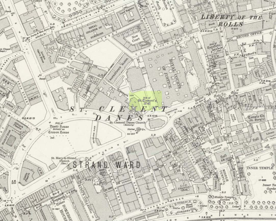
The best historical narrative of the site is undoubtedly that by Alfred Foord (1910), whose lengthy research waded through all the possible locations of the site, concluding in the Appendix of his work that, “in front of Clement’s Inn Hall…was the far-famed ‘holy well’ of St. Clement.” It’s best leaving Mr Foord to do all the talking on this one:
“The earliest mention of the well of St. Clement was made by the Anglo-Norman chronicler, FitzStephen, in his History of London, prefixed to his Life of Becket (written between the years 1180 and 1182), where in the oft-quoted passage, he describes the water as “sweete, wholesome, and cleere,” and the spot as being ”much frequented by scholars and youths of the Citie in summer evenings, when they walk forth to take the aire.”
“Turning to Stow (1598), a fairly correct idea of the position of the holy well may be formed from his remarks. Referring to Clement’s Inn, he defines it as “an Inne of Chancerie, so called because it standeth near St. Clement’s Church, but nearer to the faire fountain called Clement’s Well.” As to its condition at the time he wrote, he says: “It is yet faire and curbed square with hard stone, and is always kept clean for common use. It is always full and never wanteth water.” Seymour writes of it in his Survey of London (1734-35) as “St. Clement’s pump, or well, of note for its excellent spring water.” Maitland (1756) says of it: “The well is now covered, and a pump placed therein on the east side of Clement’s Inn and lower end of St. Clement’s Lane.” This appears to be the first specific reference to the change from a draw-well to a pump. Hughson (1806-09), and Allen (1827-29) both allude briefly to the well, but the following authors say nothing about it : Northouck, A New History of London (1773); Pennant, Some Account of London (1790 and 1793); Malcolm, Londinium Redivivum (1803-07); and Riley, Memorials of London and London Life in the Thirteenth, Fourteenth, and Fifteenth Centuries (1868).
“Among the more modern writers, John Sanders in his “Strand” article, published in Knight’s London (1842), says: “The well is now covered with a pump, but there still remains the spring, flowing as steadily and freshly as ever.”
“George Emerson (1862), in speaking of the Church, says: ”It stood near a celebrated well, which for centuries was a favourite resort for Londoners. The water was slightly medicinal, and having effected some cures, the name Holy Well was applied.”
“John Diprose, an old inhabitant of the parish of St. Clement Danes, in his account of the parish (published in two volumes in 1868 and 1876), has this passage on the subject: “It has been suggested that the Holy Well was situated on the side of the Churchyard (of St. Clement), facing Temple Bar, for here may be seen a stone-built house, looking like a burial vault above ground, which an inscription informs us was erected in 1839, to prevent people using a pump that the inhabitants had put up in 1807 over a remarkable well, which is 191 feet deep, with 150 feet of water in it. Perhaps this may be the ‘holy well’ of bygone days, that gave the name to a street adjoining.” Timbs says in his Curiosities of London (1853), “the holy well is stated to be that under the ‘Old Dog’ tavern, No. 24, Holywell Street.” Mr. Parry, an optician in that street, and an old inhabitant, held the same opinion. Mr. Diprose, on the other hand, finds “upon examination, no reason for supposing that the holy well was under the Old Dog tavern, there being much older wells near the spot.” Other inhabitants believe that the ancient well was adjacent to Lyon’s Inn, which faced Newcastle Street, between Wych Street and Holywell Street. In the Times of May 1, 1874, may be found the following paragraph, which reads like a requiem: “Another relic of Old London has lately passed away; the holy well of St. Clement, on the north of St. Clement Danes Church, has been filled in and covered over with earth and rubble, in order to form part of the foundation of the Law Courts of the future.” On the 3rd of September of the same year (1874) the Standard refers to this supposed choking up of the old well, and suggests that “there had been a mis-apprehension, for the well, instead of being choked up, was delivering into the main drainage of London something like 30,000 gallons of water daily of exquisite purity. This flow of water which wells up from the low-lying chalk through a fault in the London Clay, will be utilised for the new Law Courts.” A contributor to Notes and Queries (9th series, July 29, 1899) draws attention to the following particulars from a correspondent, a Mr. J. C. Asten, in the Morning Herald of July 5, 1899: “Having lived at No. 273, Strand, for thirty years from 1858, it may interest your readers to know that at the back of No. 274, between that house and Holy Well Street, there exists an old well, which most probably is the ‘Holy Well.’ It is now built over. I and others have frequently drunk the exceedingly cool, bright water. There was an abundance of it, for in the later years a steam-printer used it to fill his boilers.” An interesting account of another well, less likely, however, to be the true well, is given by the late Mr. G. A. Sala in Things I have Seen and People I have Met (1894), who describes the clearing of the well which was not under, but behind the ‘Old Dog,’ in Holy Well Street, where he resided for some months about 1840. One or two interesting things turned up, amongst them being a broken punch bowl, having a William and Mary guinea inserted at the bottom ; a scrap of paper with the words in faded ink, “Oliver Goldsmith, 13s. 10d.,” perhaps a tavern score, and a variety of other articles.
“The erection of the new Law Courts—1874-82—which, with the piece of garden ground on the western side, cover a space of nearly 8 acres, swept away numbers of squalid courts, alleys, and houses, including a portion of Clement’s Inn, where the well was. Further west another large area was denuded of houses, by which Holywell Street—demolished in 1901—and nearly the whole of Wych Street (a few houses on its northern side only being left), have been wiped off the map.
“In order, if possible, to obtain some corroboration of the Standard‘s statement that the spring existed in 1874, the writer applied for information on the point to the Clerk of Works 2 at the Royal Courts of Justice, who wrote that he could find no trace of St. Clement’s Well, so that the report in the Times (quoted above) is probably correct. The water-supply to the Courts of Justice, he adds in his letter of June 13, 1907, is from the Water Board’s mains, and an underground tank, used for the steam-engine boilers, situated between the principal and east blocks, is filled partly from the roofs and partly from shallow wells in the north (Carey Street) area of the building—the overflow running into the drains.
“On the Ordnance Survey Map, published in 1874, a spot is marked on the open space west of the Law Courts with the words “Site of St. Clement’s Well”: this spot is distant about 200 feet north from the Church of St. Clement Danes, and about 90 feet east of Clement’s Inn Hall, which was then standing. The Inn, with the ground attached to it, was disposed of not long after 1884, when the Society of Clement’s Inn had been disestablished.”
On the northeast side of the St. Clement’s church, a metal plaque was erected in 1807 (it’s still there!) which claims to be the position where the holy well existed. It reads:
“The well underneath, 191 feet deep, and containing 150 of water was sunk & this pump erected at the expense of the parish of St Clement Danes.”
In Mr Sunderland’s (1915) account of the Well, he told that it was located “200ft north” of the church, “covered by the Law Courts, built between 1874 and 1882”; and that although the waters here were clear and pure, they were “probably not medicinal”. Its waters, he said, fed the old Roman Spring Bath at No.5, The Strand.
In Edward Walford’s (1878) standard work, he told that,
“Round this holy well, in the early Christian era, newly-baptised converts clad in white robes were wont to assemble to commemorate Ascension Day and Whitsuntide; and in later times, after the murder of Thomas à Becket had made Canterbury the constant resort of pilgrims from all parts of England, the holy well of St. Clement was a favourite halting-place of the pious cavalcades for rest and refreshment.”
Folklore
Although I can find nothing specifically relating St. Clement’s Well with the old customs cited below, a connection seems highly likely, as the events started where Mr Foord (1910) said the holy well was located. The great english folklorist Christina Hole (1950) wrote:
“One of the most charming ceremonies in London is the Oranges and Lemons service at St. Clements Danes. It takes place every year on March 31st, or as near as possible to that date, and is a modified revival of an old custom which has only recently died out. In the lifetime of many elderly people now living, the attendants of Clements Inn used annually to visit all the residents of the Inn and present them with oranges and lemons, receiving some small gift in return. At the March service, the church is decorated with oranges and lemons, and all the children who attend are given fruit as they leave the building, while the bells play the old nursery rhyme. The oranges and lemons are supplied by the Danish colony in London, whose church this has been for many centuries, and are often distributed by Danish children wearing their national colours of red and white.”
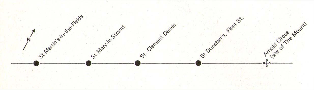
The historian Laurence Gomme (1912) propounded that the ancient stone cross of The Strand nearby, and the Strand maypole, were elements relating to an unbroken line of heathen traditions dating back to the early Saxon period—and the customs here cited would seem to increasingly validate this. A more detailed multidisciplinary analysis of this cluster of sites along The Strand by competent occult historians is long overdue.
The Strand ley (courtesy Paul Devereux)
One final thing: if the position of the Well is indeed the one cited on the 1807 plaque, to the northeast of St. Clement’s church, then it lies bang on the ley-line that was first propounded by Alfred Watkins (1922; 1925; 1927), and subsequently enlarged upon by Devereux & Thompson! (1979)
References:
Devereux, Paul & Thomson, Ian, The Ley Hunter’s Companion, Thames & Hudson: London 1979.
Foord, Alfred Stanley, Springs, Streams and Spas of London: History and Association, T. Fisher Unwin: London 1910.
Gomme, Laurence, The Making of London, Clarendon: Oxford 1912.
Gover, J.E.B., Mawer, Allen & Stenton, F.M., The Place-Names of Middlesex, Cambridge University Press 1942.
Hole, Christina, English Custom and Usage, Batsford: London 1950.
Johnson, Walter, Byways in British Archaeology, Cambridge University Press 1912.
Street, Christopher E., London’s Ley Lines, Earthstars: London 2010.
Sunderland, Septimus, Old London Spas, Baths and Wells, John Bale: London 1915.
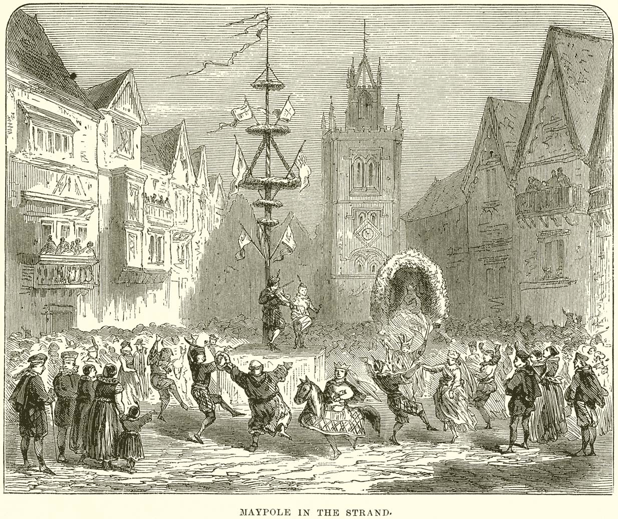
Maypole (destroyed): OS Grid Reference – TQ 3073 8092
Archaeology & History
This huge traditional monument was once a sight to behold! It stood close to where an ancient stone ‘cross’ once lived. But—alas!, with the intrusion of the incoming christians bringing a profane ‘religion’ that belongs to countries far from here, its destruction was imposed. They destroyed so many of our ancient monuments with their hatred and ignorance… But thankfully we have some good accounts of this long-forgotten relic of London’s real history.
In A.R. Wright’s (1938) account of it, he called this “the most famous maypole in England” and it stood taller than even the great maypole that’s still raised at Barwick-in-Elmet, in Yorkshire.
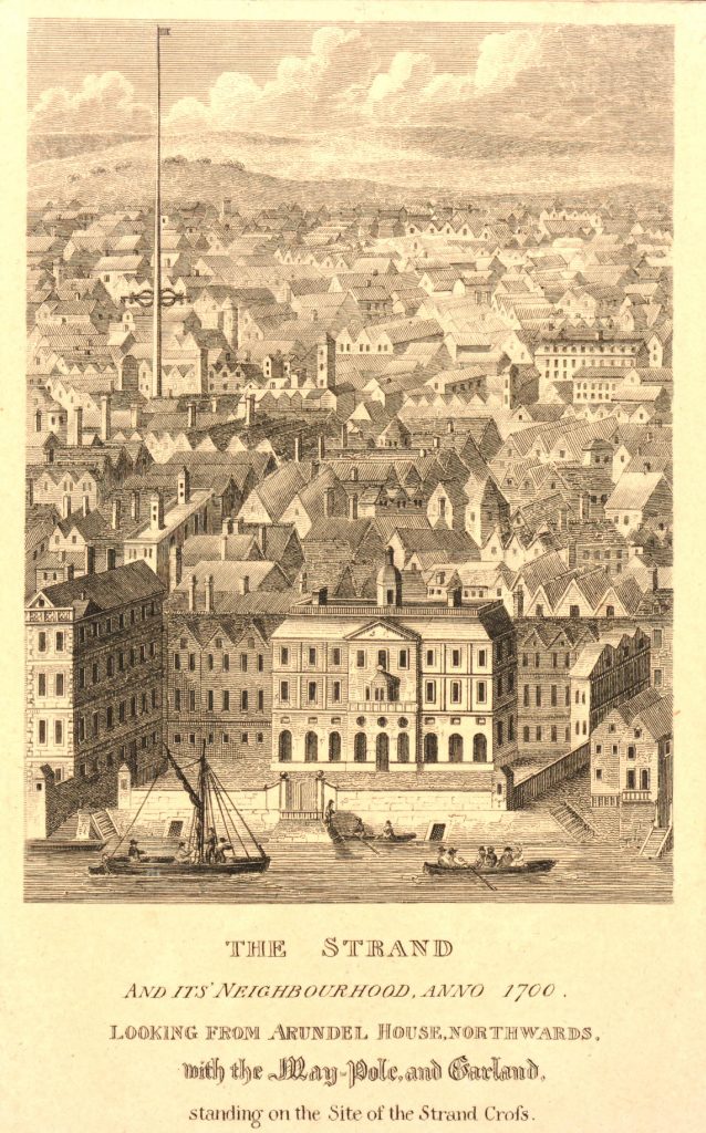
There seems to have been three maypoles on this same site – the first of which was standing before the destruction of Strand’s ancient cross, where local jurisdictions and early village meetings took place. We don’t know the date when the first maypole was erected, but it was shown on a local plan of the area “which Anthony van den Wyngaerde issued in 1543…in front of the old church of St. Mary le Strand, which was demolished in 1549.” According to Mr Hone (1826), it could be found a door or two westward beyond “where Catherine Street descends into the Strand.”
In Edward Walford’s (1878) massive tome, he gave us perhaps the best and most extensive account of the site, telling:
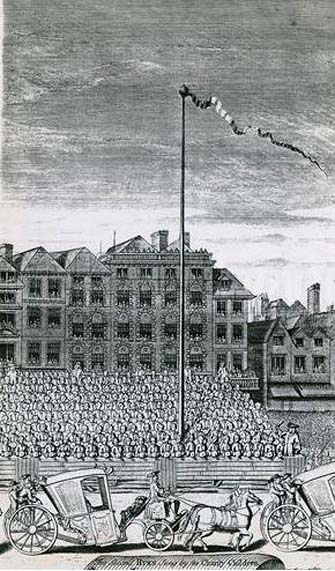
“The Maypole, to which we have already referred as formerly standing on the site of the church of St. Mary-le-Strand, was called by the Puritans one of the “last remnants of vile heathenism, round which people in holiday times used to dance, quite ignorant of its original intent and meaning.” Each May morning, as our readers are doubtless aware, it was customary to deck these poles with wreaths of flowers, round which the people danced pretty nearly the whole day. A severe blow was given to these merry-makings by the Puritans, and in 1644 a Parliamentary ordinance swept them all away, including this very famous one, which, according to old Stow, stood 100 feet high.
On the Restoration, however, a new and loftier one was set up amid much ceremony and rejoicing. From a tract printed at the time, entitled ‘The Citie’s Loyaltie Displayed,’ we learn that this Maypole was 134 feet high, and was erected upon the cost of the parishioners there adjacent, and the gracious consent of his sacred Majesty, with the illustrious Prince the Duke of York:
“This tree was a most choice and remarkable piece; ’twas made below bridge and brought in two parts up to Scotland Yard, near the king’s palace, and from thence it was conveyed, April 14, 1661, to the Strand, to be erected. It was brought with a streamer flourishing before it, drums beating all the way, and other sorts of musick. It was supposed to be so long that landsmen could not possibly raise it. Prince James, Duke of York, Lord High Admiral of England, commanded twelve seamen off aboard ship to come and officiate the business; whereupon they came, and brought their cables, pullies, and other tackling, and six great anchors. After these were brought three crowns, borne by three men bareheaded, and a streamer displaying all the way before them, drums beating and other musick playing, numerous multitudes of people thronging the streets, with great shouts and acclamations, all day long. The Maypole then being joined together and looped about with bands of iron, the crown and cane, with the king’s arms richly gilded, was placed on the head of it; a large hoop, like a balcony, was about the middle of it. Then, amid sounds of trumpets and drums, and loud cheerings, and the shouts of the people, the Maypole, ‘far more glorious, bigger, and higher than ever any one that stood before it,’ was raised upright, which highly did please the Merrie Monarch and the illustrious Prince, Duke of York; and the little children did much rejoice, and ancient people did clap their hands, saying golden days began to appear.”
A party of morris-dancers now came forward, “finely decked with purple scarfs, in their half-shirts, with a tabor and a pipe, the ancient music, and danced round about the Maypole.”
The setting up of this Maypole is said to have been the deed of a blacksmith, John Clarges, who lived hard by, and whose daughter Anne had been so fortunate in her matrimonial career as to secure for her husband no less a celebrated person than General Monk, Duke of Albemarle, in the reign of Charles II., when courtiers and princes did not always look to the highest rank for their wives.
…Newcastle Street, at the north-east corner of the church of St. Mary-le-Strand, was formerly called Maypole Alley, but early in the last century was changed to its present name, after John Holles, Duke of Newcastle, the then owner of the property, and the name has been transferred to another place not far off. At the junction of Drury Lane and Wych Street, on the north side, close to the Olympic Theatre, is a narrow court, which is now known as Maypole Alley, near which stood the forge of John Clarges, the blacksmith, alluded to above as having set up the Maypole at the time of the Restoration.
As all earthly glories are doomed in time to fade, so this gaily-bedecked Maypole, after standing for upwards of fifty years, had become so decayed in the ground, that it was deemed necessary to replace it by a new one. Accordingly, it was removed in 1713, and a new one erected in its place a little further to the west, nearly opposite to Somerset House, where now stands a drinking fountain. It was set up on the 4th of July in that year, with great joy and festivity, but it was destined to be short-lived. When this latter Maypole was taken down in its turn, Sir Isaac Newton, who lived near Leicester Fields, bought it from the parishioners, and sent it as a present to his friend, the Rev. Mr. Pound, at Wanstead in Essex, who obtained leave from his squire, Lord Castlemaine, to erect it in Wanstead Park, for the support of what then was the largest telescope in Europe, being 125 feet in length. It was constructed by Huygens, and presented by him to the Royal Society, of which he was a member. It had not long stood in the park, when one morning some amusing verses were found affixed to the Maypole, alluding to its change of position and employment. They are given by Pennant as follows:
“Once I adorned the Strand,
But now have found
My way to Pound
On Baron Newton’s land;
Where my aspiring head aloft is reared,
T’ observe the motions of th’ ethereal Lord.
Here sometimes raised a machine by my side,
Through which is seen the sparkling milky tide;
Here oft I’m scented with a balmy dew,
A pleasant blessing which the Strand ne’er knew.
There stood I only to receive abuse,
But here converted to a nobler use;
So that with me all passengers will say,
‘I’m better far than when the Pole of May.'”
Along with the Strand Cross, this old maypole would have been on the ancient ley (not one of those ‘energy lines’ invented by New Age fantasists) that was first described first by Alfred Watkins (1925)—running from St. Martins-in-the-Field to St. Dunstan’s in Fleet Street. The alignment and maypole was subsequently described in greater detail in Devereux & Thomson’s (1979) work on the same subject, and again by Chris Street. (2010)
The nature of the maypole (and the nearby cross, it has to be said), may have been representative of an omphalos in early popular culture (before the christians of course)—which would put the original ritual function of the place far far earlier than is generally considered. This is something that Laurence Gomme (1912) propounded in one of his London works and cannot be discounted.
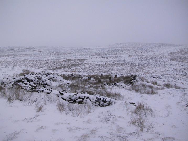
The ruins of Backstone Circle (photo, Richard Stroud)
There are many routes to get here, but this is the one I usually take. From Cow & Calf Rocks, walk up the steep hillside onto the first moorland plain, taking the path right, diagonally, across to the NW as if you’re heading to the Map Stone. From here, looking down at the stream valley below, follow the valley edge up, past the settlement, and then veer down to Backstone Beck and up on the other side till you meet with a footpath and also up in the heather ahead of you, notice the jumbled walling less than 100 yards away. That’s where you need to be!
Archaeology & History
A singular short sentence in Robert Collyer and J.H. Turner’s Ilkley, Ancient and Modern (1885) started it all off, where they told:
“There was still a rude circle of rocks on the reach beyond White Wells fifty years ago, tumbled into such confusion that you had to look once, and again, before you saw what lay under your eyes.”
…..And thankfully this is still what we see today – and in just the area they mentioned.
I’m intrigued to find there’s so much said about this site on the Net and feel I should put my recent feelings about the place to print at last (and after being badgered to gerrit done by James Elkington!). The information about its make-up and the mess it’s in, hasn’t changed since we rediscovered the place on June 3, 1989. Here, amidst the tall grasses and reeds of Juncus effusus and J. conglomeratus, our jumble of megaliths hides within a breakdown of fallen walls, that are thought to have been part of some sheep-fold or a similar animal enclosure (mebbe for the annual sheep-shagging contests that are held, quietly, on these moors each year!).
The name ‘backstone’ itself come from the adjacent beck (slowly depleting as the years pulse by) and is mentioned in the 18th century parish registers. A.H. Smith (1961) informs us that it was the “stream where bakestones were got”, and this was probably a tradition going way way back. The baking stones from the beck may even have been used by the people living in the prehistoric settlements close to the circle.
Stones amidst the reeds
In what looks today like a messy double-ring of stones, it’s likely there was originally just a single ring which has, subsequently, been knocked down and re-used for some form of sheep-fondling sessions—be it agricultural or otherwise! But for the record at least: we have small inner ‘ring’ of four upright stones, re-worked in more recent centuries, between two-and-a-half to three-and-a-half feet tall. Another stone is recumbent. The outer ring is more conspicuous. It consists of at least eight standing stones–seven of which are upright–between three and five feet tall, some of which have been re-worked in more recent times. There are several other stones either recumbent or partly covered by vegetation. The tallest of the stones is 4’11” tall. The outer circle has had at least one of the stones uprooted and used at the base of the dry-stone walling intruding the southwest side of the circle. What appears to be at least two original standing stones are embedded into earthworks on the other side of this wall, one of which was located through dowsing!
The best section of the ring can be seen on its eastern side, where an arc of upright stones between three and four feet high are still clearly in evidence, just inside a raised embankment like that found surrounding the Twelve Apostles stone circle less than a mile away.
A short while after finding the site, we contacted the Ilkley Head of Archaeology Studies, Gavin Edwards, about the circle and he subsequently included the site on one of the tourist-guides to the moors.
Alignments through this circle seem apparent in situ; and although such alignments are intriguing (to me anyhow), it’s the geometric relationship Backstone has with other circles on these moors that is rather notable. It’s position in the landscape plays an essential part in an isosceles triangle formation, 1180 yards [1.08km] from the Twelve Apostles stone circle which, as the centre point, is another 1180 yards from the Roms Law Circle. Odd….
Immediately visible from our ruinous circle across the small valley to the slopes of Green Crag, the Ilkley Archaeology Group spent more than fifteen years excavating the remains of what was initially thought of as a Bronze Age village, but their work here has proved startling, pushing the date of human occupation here into the mesolithic period! Local archaeologist Gavin Edwards opined that the Backstone circle would have been the religious site for the people who lived here. I have to concur. There are also more neolithic and Bronze Age walling, indicative of extended settlements and enclosures, less than 200 yards north of the Backstone Circle, structurally consistent with the remains across the valley at the excavated Green Crag Slack settlement.
Ten yards east of the circle is a small well which only runs following exceptional rainfall. This was probably of some ritual importance to the people who practiced rites here. Geological fault lines run not far away on three sides of the ring and an underground stream is present, quite close to the surface (as indicated by the presence of Juncus conglomeratus and J.effisus), encouraging the preponderance of regular electromagnetic variations: these in particular are likely to have some causative influence on the paranormal events described below….
Fortean History
Since rediscovering this site, a number of bizarre psychophysical anomalies have been experienced and described by more and more people — some of whom were previously very sceptical of such things. Both day and night, no doubt when Moon and water speak their subtle electromagnetic accord, a gathering corpus of all-too-familiar events keep speaking of a most disturbing resident spirit…
We begin on Wednesday, July 12, 1989, sometime around midnight, when an acquaintance and I were spending a few days here to record any possible electromagnetic anomalies at this disturbed ring of stones. We weren’t to be disappointed, as something very untoward raised its peculiar head.
As I sat barely ten yards beyond the tumbled group of stones there suddenly appeared, from nowhere, a host of figures—a dozen at most—walking ever so slowly around the old site. I could discern no physical features other than their height and humanoid shape. It was just too dark to see any details about them—they were, effectively, silhouettes. My acquaintance was terrified—although it was perhaps a minute or so before he even glanced at what I was pointing and exclaiming at, somewhat manically, stuttering and shaking my head in an attempt to make the things disappear back to my unconscious where they surely originated. Didn’t work though!
These were no psychic projections. I literally shook my head, closed my eyes and knocked my head against the walling; looked away, shook my head again, shouting at myself and looked back at the figures in front of us. It still didn’t do a damn thing! By now my friend was staring, aghast and scared shitless if the expression on his face was anything to go by.
“Wot a’ y’ seeing? Wot can y’ see?” I asked.
He murmured and mumbled something about some people he could see, walking round and round the old remains.
He was seeing exactly the same as what I could see. As the minutes passed by, this group of people, who were winding in and out of each and every stone and walking through the intrusive walling as it was not there, slowly but surely, ever so gradually, increased in speed. This was very slow and patient and went on for at least fifteen minutes — by which times they were barely visible as individual figures anymore. All we could see by now was a visual blur and a remarkable vortex that was created in the wake of their ‘dance’.
This spinning vortex of silhouettes seemed to get faster and faster until appearing to reach a sort of critical speed/energy state — and as this “critical state” occurred, what was by now a rapid spinning, energetic blur simply vanished right before our eyes! It was as if someone, somewhere, had flicked a switch and they disappeared. Yet, at the very same moment the blurred vortex vanished, several dead straight lines of orange-red appeared in their place. These were as baffling as the dance we had just watched: very thin, wavering lines of what I can only describe as subtle light, bounced off several of the standing stones. These lines—perhaps four of them—did not originate from the circle but appeared to come from further afield. One in particular seemed to come from the direction of the great boulder known as the Idol Rock, 700 yards [650m] east and continued past our field of vision in the direction of the Swastika Stone.
To be honest these “lines of energy” perturbed me more than the spinning figures which had just disappeared. Not only were these lines two-dimensional [a real screw-up that one!], I was at a loss to explain what these lines really were. The first thought was, of course, leys – but my idea of leys did not, and still does not accord with what I was seeing. Eventually the lines faded back to wherever they came, leaving both of us wondering what the hell we had just experienced.
Several minutes after talking over what had just happened, I stood up and walked into the circle. At this point, please remember it was July 12 and the night was so warm that neither of us had taken sleeping bags or a tent onto the high moors with us. As I got to the circle and took my first step inside, a tremendous shiver hit right through my body, almost like I was walking into a freezer. But I moved another step forward, unperturbed if truth be had by the probable chill wind that made me shiver. As I did so, the chill became more manifest and intense. As I took my third step forward the cold became biting and I collapsed onto my knees. [This is not like me, honest. Give me camping in the Scottish mountains in mid-February with average temperatures of -6 degrees and that’s my idea of a good night out!]
Shivering like hell, I stumbled upright and back onto my feet and virtually ran out of the circle. That, more than anything else that night, truly perturbed me.
The following morning another volunteer joined us. We told him about the events of the previous night and he thought whatever he thought; but he’d brought two thermometers with him and set them on two of the rocks: one of them about 25 yards outside the circle, the other on a stone in the circle. The two of them had the same reading: 73° F. We left them without checking for a good hour or so and then began to take readings. What transpired was bizarre to say the least: the one outside the circle was 62° F, the one in the circle was 72° F. A further reading fifteen minutes later, close to sunset, showed the temperature variations had come a little closer: the inner reading was 70° F, and outer reading still 62° F. Readings were then taken every fifteen minutes and the respective readings closed in on each other until both were the same, exactly when the sun was touching the horizon to set, at 9.05pm. But this was not the end of the anomaly. While the temperature outside the circle dropped naturally with nightfall, finally resting at 57-58° F, the inner circle reading continued falling at nearly twice the background rate! Our final reading after 11pm showed a deviation of nearly 7 degrees between the respective thermometers!
If these elements seem in anyway somewhat unbelievable, what occurred next bends the parameters of reality still further!
No further anomalous Fortean events happened at the circle that night—for us at least. However, a friend in Leeds—the internationally renowned ritual magician and author, Phil Hine—was at home with some friends, chatting.
“On the night in question,” he came to write sometime later, “I was talking to another magickian. He returned from the toilet and informed me that there was an “entity” lurking in the stairwell… This was unusual, but not sufficiently unusual to cause undue concern, and so, picking up my thunderbolt, I went out to see what was what. In the stairwell we both agreed on seeing a black amorphous shape. Since my friend had first noticed this, I asked him if he would be prepared to “open his mind” to it, so that I could question it, using him as an interface [which was one of his particular talents] and a fairly accepted procedure for questioning strange entities. “The entity declared,” I have come from the ancient hills.” It also stated that it had been “awakened” only recently due to activity around a sacred site. It said that it had come to give me “power” with which I could do something, but was reticent about the exact nature of this. When I asked what it would do if I rejected this, it said that it would return “screaming to the hills.” When I asked it to identify itself it gave the name Azathoth—which could well have sprung from the mind of my friend, although he had no particular knowledge of the Cthulu mythos entities.”
Phil continued:
“At the time I found it difficult to credit that such a powerful entity would be hanging politely about in the stairwell waiting to be noticed. Being unable to obtain a direct answer to my questions, I told it to go forth, which it apparently did. I later had to perform an intense banishing ritual on my friend who was suffering from symptoms such as feeling cold, a tight pressure on the chest, personality displacement, and motor spasms… Unbeknownst to me at the time, two friends of mine who were members of the West Yorkshire Earth Mysteries Group had experienced a strange encounter at the then newly-uncovered Backstone Circle on Ilkley Moor… It seems strange, on reflection, that the appearance of the entity claiming to originate from a newly disturbed site seems to relate to their experience.” [Hine 1994, 1997]
Other bizarre experiences at the circle itself have been reported by growing numbers of people—a lot of them quite unpleasant. One lady, Katy from Calderdale, whose interest in megaliths rarely stretched into the obscurities of their folklore or weird tales, will “probably never go there again. It terrified me. I don’t know why, there was nothing to be scared of, but the place just felt awful.”
There have been at least a dozen people who have related the same words to me—and I can empathise. On February 14, 1990, Mick N. and I went to the site for the night with intent to do a bit of sympathetic ritual magick. The night was cold and a slight fall of snow glittered across the moors as far as we could see, invoking quite healthy feelings about the forthcoming rite. But as we turned off the path and approached the stones, it was as if we had walked through an invisible gate or door just yards before the circle itself, screaming quite powerfully with gnarled teeth that we were not wanted there that night! It was overwhelming! We both acted accordingly and spent the night elsewhere, cold and querying over its genius loci. The potency of Azathoth seemed inherent in its silent voice.
This particular feeling, almost of malevolance, has been described by many people at Backstone. It occurs both day and night and is akin to what Prof Thomas Lethbridge (1961) described as ‘ghouls’: place-memories so to speak, or spirits of place. Most of the time there is no such feeling, of course. But when conditions are right, these potent subjective consumations can be quite overwhelming at some spots. They are reported worldwide in the aboriginal traditions of all races and are felt, obviously, even today by explorers, mountaineers and visitors to ancient haunted places like the Backstone Circle.
Strange lights have also been seen over and around here by a number of witnesses. On one occasion a ritual invocation of its spirit-nature brought forth a number of glowing red spheres of light. These were about the size of footballs, appearing for a minute or two, floating in front and around us, then vanishing—only to reappear yards away around the edges of the damaged ring of stones. These were very obviously living things and were examining us with equal bewilderment. Other light-phenomena that people have seen here and on this moor appear to relate to the phases of the Moon.
Although the site is quite ruinous, it is a worthwhile place to visit – just respect, and beware the Old Hag who sometimes comes forth from time to time….
References:
Bennett, Paul., “The Backstone Circle,” Earth 15, 1990.
Bennett, Paul, “Archaeological and Geometrical Applications of the Lost Stone Circle of Ilkley Moor,” Earth 15, 1990.
Bennett, Paul, Circles, Standing Stones and Legendary Rocks of West Yorkshire, Heart of Albion Press: Wymeswold 1994.
Bennett, Paul, “The Strange Case of Backstone Circle,” Right Times 1, 1998.
Bennett, Paul, The Old Stones of Elmet, Capall Bann: Milverton 2001.
Collyer, Robert & Turner, J. Horsfall, Ilkley: Ancient and Modern, William Walker: Otley 1885.
Devereux, Paul, Places of Power, Blandford: London 1990.
Gyrus T., “An Interview with Phil Hine,” Towards 2012 volume 4, 1998.
Hine, Phil, “The Physics of Evocation,” Chaos International 1990.
Roberts, Andy, Ghosts and Legends of Yorkshire, Jarrold: Norwich 1997.
Smith, A.H., The Place-Names of the West Riding of Yorkshire – volume 4, Cambridge University Press 1961.
Acknowledgements: Many thanks to Richard Stroud for his photo of Backstone at winter time; to James Elkington for saying, “Come on Paul – get yer finger out!” + his photos too…
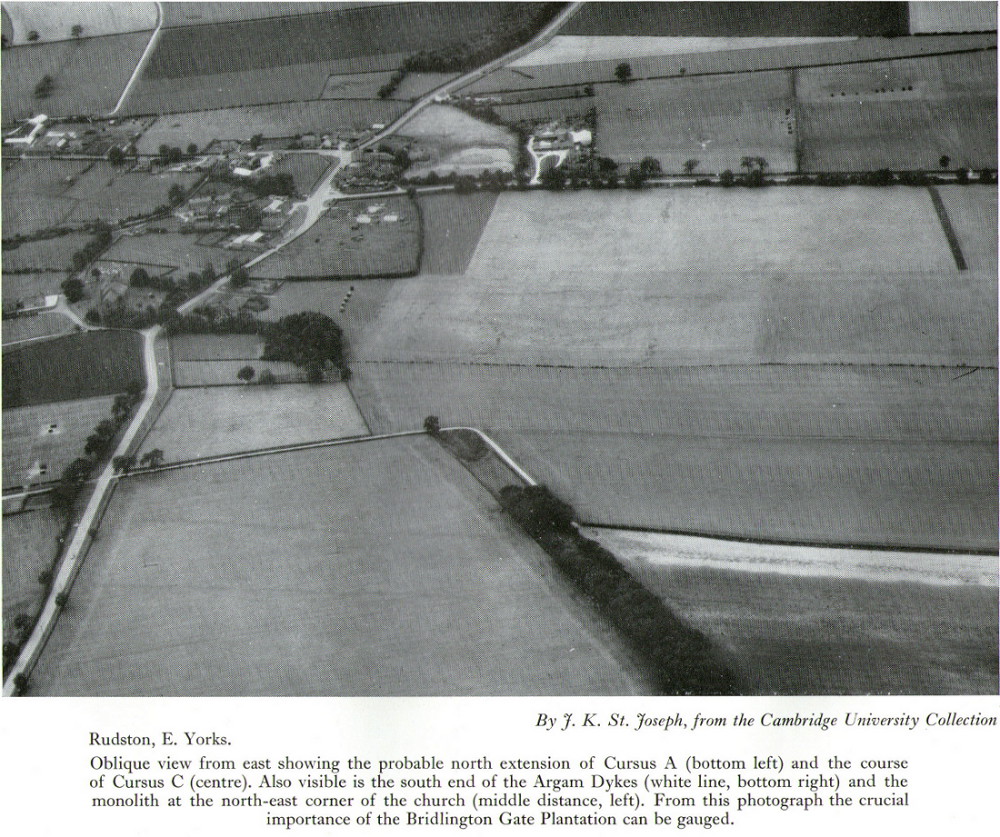
Plan of Rudston D Cursus & associated monuments (after I.M. Stead 1976)
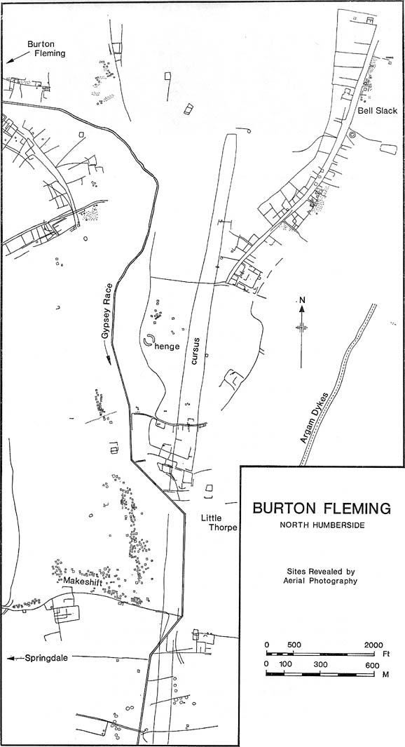
To the north of Rudston village and its giant standing stone, running roughly parallel with the divinatory waters of the Gypsey Race river and passing a mass of prehistoric remains en route, we find one the biggest prehistoric cursus monuments in the British Isles: the Rudston D cursus. More than twice as long as any of the three other cursus monuments nearby, its northern end or ‘terminal’ is flattened in nature (others are rounded) and is due east of the village of Burton Fleming starting at the intriguingly-named Maidens Grave field, just as the land begins to rise at TA 099 717. From here it begins its almost southern trajectory and runs almost dead straight for several hundred yards until edging, ever so slightly in direction, to a slightly more secure southern alignment. Past the site of the Rudston henge, the cursus broadens out slightly and, as it reaches the farmlands of Littlethorpe, edges slightly further to a more decisive direct southern route. The cursus then maintains a dead straight course for another mile, heading straight for, and stopping just short of the Rudston monolith in its modern churchyard. A short distance before we reach its southern end, archaeologists found that a section of the Cursus C monument cut right across it. Altogether, the Rudston D Cursus is more than 4km (2.3 miles) long! At its narrowest width, this monument is a mere 160 feet (50m) across, and at its widest is 280 feet (90m). A giant by anyone’s standard!
Along the entire length of this continuous ditch and inner bank there were just 3 small cuttings on the western side and three on the east, but two of the eastern openings were quite large. Some of these openings were affected by natural elements and others by modern agriculture. Today, much of this gigantic ritual monument (as the archaeologists call them) is not visible at ground level.
In visiting this area, make yourself aware of the other monuments in this class: the Rudston A cursus and Rudston B cursus, southeast and southwest of here respectively. A full multidisciplinary analysis of the antiquities in this region is long overdue. To our ancestors, the mythic terrain and emergent monuments hereby related to each other symbiotically, as both primary aspects (natural) and epiphenomena (man-made) of terra mater: a phenomenon long known to comparative religious students and anthropologists exploring the animistic natural relationship of landscape, tribal groups and monuments.
References:
Burl, Aubrey, Rites of the Gods, J.M. Dent: London 1981.
Harding, Jan, ‘Pathways to New Realms: Cursus Monuments and Symbolic Territories,’ in Barclay & Harding, Pathways and Ceremonies: The Cursus Monuments of Britain and Ireland, Oxbow: Oxford 1999.
Loveday, Roy, Inscribed Across the Landscape: The Cursus Enigma, Tempus: Stroud 2006.
Pennick, Nigel & Devereux, Paul, Lines on the Landscape, Hale: London 1989.
Stead, I.M., ‘La Tene Burials between Burton Fleming and Rudston,’ in Antiquaries Journal, volume LVI Part II, 1976.
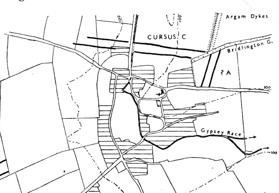
Of the four giant linear cursus monuments that were laid out around the landscape that holds Britain’s largest standing stone—the Rudston monolith—this one, the Rudston ‘C’ cursus, is the one we know the least about. This is mainly due to it receiving the minimum of archaeological attention, which can be forgiven round here as there is so much material to explore! Traces of the cursus at ground level are also quite negligible. Thankfully however, like the other cursus monuments nearby, some of the site can be made out on GoogleEarth.
The alignment of this cursus runs east-to-west, cutting across the Cursus D monument and then running above the northern course of Nature’s curious river known as the Gypsey Race, which local folklore ascribes as being used in animistic divinatory practices. Cursus C was first noticed in aerial photographs taken by Prof. J.K. St. Joseph in 1961 and first described by D.P. Dymond (1966) a few years later, who told us:
“Immediately north of the village (Rudston), two parallel ditches, about 60 yards apart, are visible as crop-marks running east-west for 1000 yards… As they are too far apart to be considered as road-ditches and are similar to the linear ditches (of Rudston A and B), they are best interpreted as a fragment of a third cursus, C. The western end fades out near the York road as it climbs onto high ground, while at the east the ditches disappear into Bridlington Gate Plantation. Like Cursus A, this also crossed the Gypsey Race. Approximately 1½ miles northwest of the last westward point of these ditches is the presumed site of two lost long barrows, joined together at one end. There may, therefore, have been an original connection between Cursus C and these long barrows.”
First faint photo of Cursus C
His final remark is quite a good one! And since Dymond’s initial description (according to the PastScape lads anyhow), Cursus C has been found to be much longer than the initial 1000 yards, growing another 500 yards at least! The final point or ‘terminal’ on the eastern end still remains hidden, as it was intruded upon by the later Argham Dyke and the trees. The start or western terminal also remains unfound, so we don’t know for sure the exact length of this giant neolithic ‘line on the landscape’, as Pennick and Devereux (1989) call them.
References:
Dymond, D.P., “Ritual Monuments at Rudston, E. Yorkshire, England,” in Proceedings of the Prehistoric Society, volume 32, 1966.
Harding, Jan, ‘Pathways to New Realms: Cursus Monuments and Symbolic Territories,’ in Barclay & Harding, Pathways and Ceremonies: The Cursus Monuments of Britain and Ireland, Oxbow: Oxford 1999.
Loveday, Roy, Inscribed Across the Landscape: The Cursus Enigma, Tempus: Stroud 2006.
Manby, T.G., “The Neolithic in Eastern Yorkshire,” in Archaeology in Eastern Yorkshire, University of Sheffield 1988.
Pennick, Nigel & Devereux, Paul, Lines on the Landscape, Hale: London 1989.
Stead, I.M., ‘La Tene Burials between Burton Fleming and Rudston,’ in Antiquaries Journal, volume LVI Part II, 1976.
Looking dead straight from the Hill of Ballunie to Leys.
There seems to be nothing left of the stone circle described in Andrew Jervise’s (1879) immense work which, sadly, only described this stone circle in passing. He told us simply that hereby, “are also the remains of stone circles upon the hill of Ballunie,” which is just a few hundred yards along the road from the magnificent Keillor Pictish symbol stone. When we visited the place not long ago, no trace of any stones were visible hereby. The site is not listed in Burl’s (2000) magnum opus.
However, ley-hunters will love this place. Not only was this lost circle located at the edge of a dead straight road, running from the Keillor standing stone a short distant east, but as it runs downhill it reaches, a couple of miles below, the hamlet called Leys.
References:
Jervise, Andrew, Epitaphs and Inscriptions from Burial Grounds and Old Buildings in the North-East of Scotland – volume 2, Edmonston & Douglas: Edinburgh 1875.