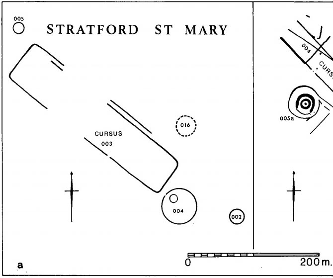
Faint flat outline of SE end + ancient circular enclosure
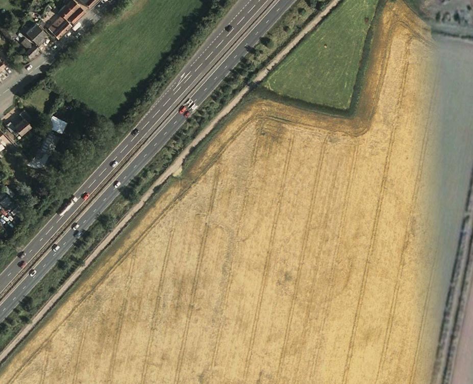
This short and dead straight cursus monument was first described in John Hedges’ (1981) survey, and later mentioned in Harding & Lee’s (1987) corpus on British henges as being in conjunction with a series of circular prehistoric monuments (three circular enclosures existed beyond its southeast and one to its northeast edges, one of which is visible in the aerial image, right).
Cursus ground-plan (courtesy Suffolk Institute Archaeology)
Most of the monument has been completely destroyed by roads and housing, but when complete was said to be 317 yards (290m) long, running from the southeast to the northwest. The flattened southeastern edge measures nearly 63 yards (57.3m) across, and its northernmost width was close to 65 yards (60m) wide.
In Patrick Taylor’s (2015) assessment of this (and other monuments) he thought that the cursus may have served an astronomical function. He may be right. It’s alignment, he told,
“has a very clear orientation 38.5º north of grid west. This represents an amplitude from true west of 40.9º. Allowing for a latitude of 51.97º and altitude of 0.95º, adjusted downwards for refraction to 0.50º, we get from (Alexander) Thom’s table a declination for a body setting to the northwest of 24.15.º This is only 0.23º, just less than half the width of the sun’s disc, more than the sun’s maximum declination in Neolithic times of 23.92º. The alignment thus points rather accurately towards the upper limb or last setting point of the sun.”
Faint remnants of a second cursus monument have been discovered 400 yards to the east.
References:
Harding, A.F. & Lee, G.E.,, Henge Monuments and Related Sites of Great Britain, BAR 175: Oxford 1987.
Hedges, John D. & Buckley, David, Springfield Cursus and the Cursus Problem, ECC 1981.
Last, Jonathan, “Out of Line: Cursuses and Monument Typology in Eastern England,” in Barclay & Harding’s Pathways & Ceremonies, Oxbow: Oxford 1999.
Martin, Edward A., “When is a Henge not a Henge?” in Proceedings of the Suffolk Institute for Archaeology & History, volume 35, 1981.
Acknowledgements: Many thanks to the Suffolk Institute of Archaeology and History, for use of their ground-plan diagram from Edward Armstrong’s article, ‘When is a Henge Not a Henge?’
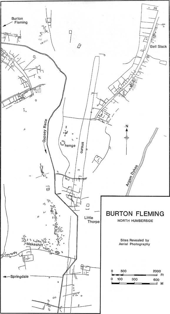
Plan of Rudston D Cursus & associated monuments (after I.M. Stead 1976)
To the north of Rudston village and its giant standing stone, running roughly parallel with the divinatory waters of the Gypsey Race river and passing a mass of prehistoric remains en route, we find one the biggest prehistoric cursus monuments in the British Isles: the Rudston D cursus. More than twice as long as any of the three other cursus monuments nearby, its northern end or ‘terminal’ is flattened in nature (others are rounded) and is due east of the village of Burton Fleming starting at the intriguingly-named Maidens Grave field, just as the land begins to rise at TA 099 717. From here it begins its almost southern trajectory and runs almost dead straight for several hundred yards until edging, ever so slightly in direction, to a slightly more secure southern alignment. Past the site of the Rudston henge, the cursus broadens out slightly and, as it reaches the farmlands of Littlethorpe, edges slightly further to a more decisive direct southern route. The cursus then maintains a dead straight course for another mile, heading straight for, and stopping just short of the Rudston monolith in its modern churchyard. A short distance before we reach its southern end, archaeologists found that a section of the Cursus C monument cut right across it. Altogether, the Rudston D Cursus is more than 4km (2.3 miles) long! At its narrowest width, this monument is a mere 160 feet (50m) across, and at its widest is 280 feet (90m). A giant by anyone’s standard!
Along the entire length of this continuous ditch and inner bank there were just 3 small cuttings on the western side and three on the east, but two of the eastern openings were quite large. Some of these openings were affected by natural elements and others by modern agriculture. Today, much of this gigantic ritual monument (as the archaeologists call them) is not visible at ground level.
In visiting this area, make yourself aware of the other monuments in this class: the Rudston A cursus and Rudston B cursus, southeast and southwest of here respectively. A full multidisciplinary analysis of the antiquities in this region is long overdue. To our ancestors, the mythic terrain and emergent monuments hereby related to each other symbiotically, as both primary aspects (natural) and epiphenomena (man-made) of terra mater: a phenomenon long known to comparative religious students and anthropologists exploring the animistic natural relationship of landscape, tribal groups and monuments.
References:
Burl, Aubrey, Rites of the Gods, J.M. Dent: London 1981.
Harding, Jan, ‘Pathways to New Realms: Cursus Monuments and Symbolic Territories,’ in Barclay & Harding, Pathways and Ceremonies: The Cursus Monuments of Britain and Ireland, Oxbow: Oxford 1999.
Loveday, Roy, Inscribed Across the Landscape: The Cursus Enigma, Tempus: Stroud 2006.
Pennick, Nigel & Devereux, Paul, Lines on the Landscape, Hale: London 1989.
Stead, I.M., ‘La Tene Burials between Burton Fleming and Rudston,’ in Antiquaries Journal, volume LVI Part II, 1976.
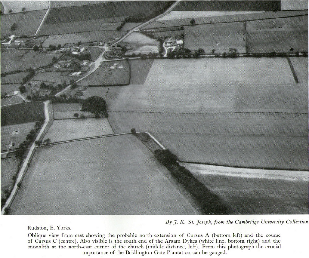
Of the four giant linear cursus monuments that were laid out around the landscape that holds Britain’s largest standing stone—the Rudston monolith—this one, the Rudston ‘C’ cursus, is the one we know the least about. This is mainly due to it receiving the minimum of archaeological attention, which can be forgiven round here as there is so much material to explore! Traces of the cursus at ground level are also quite negligible. Thankfully however, like the other cursus monuments nearby, some of the site can be made out on GoogleEarth.
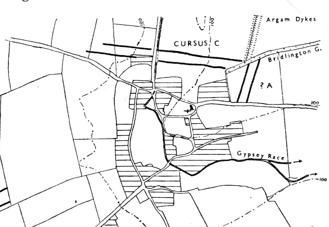
The alignment of this cursus runs east-to-west, cutting across the Cursus D monument and then running above the northern course of Nature’s curious river known as the Gypsey Race, which local folklore ascribes as being used in animistic divinatory practices. Cursus C was first noticed in aerial photographs taken by Prof. J.K. St. Joseph in 1961 and first described by D.P. Dymond (1966) a few years later, who told us:
“Immediately north of the village (Rudston), two parallel ditches, about 60 yards apart, are visible as crop-marks running east-west for 1000 yards… As they are too far apart to be considered as road-ditches and are similar to the linear ditches (of Rudston A and B), they are best interpreted as a fragment of a third cursus, C. The western end fades out near the York road as it climbs onto high ground, while at the east the ditches disappear into Bridlington Gate Plantation. Like Cursus A, this also crossed the Gypsey Race. Approximately 1½ miles northwest of the last westward point of these ditches is the presumed site of two lost long barrows, joined together at one end. There may, therefore, have been an original connection between Cursus C and these long barrows.”
First faint photo of Cursus C
His final remark is quite a good one! And since Dymond’s initial description (according to the PastScape lads anyhow), Cursus C has been found to be much longer than the initial 1000 yards, growing another 500 yards at least! The final point or ‘terminal’ on the eastern end still remains hidden, as it was intruded upon by the later Argham Dyke and the trees. The start or western terminal also remains unfound, so we don’t know for sure the exact length of this giant neolithic ‘line on the landscape’, as Pennick and Devereux (1989) call them.
References:
Dymond, D.P., “Ritual Monuments at Rudston, E. Yorkshire, England,” in Proceedings of the Prehistoric Society, volume 32, 1966.
Harding, Jan, ‘Pathways to New Realms: Cursus Monuments and Symbolic Territories,’ in Barclay & Harding, Pathways and Ceremonies: The Cursus Monuments of Britain and Ireland, Oxbow: Oxford 1999.
Loveday, Roy, Inscribed Across the Landscape: The Cursus Enigma, Tempus: Stroud 2006.
Manby, T.G., “The Neolithic in Eastern Yorkshire,” in Archaeology in Eastern Yorkshire, University of Sheffield 1988.
Pennick, Nigel & Devereux, Paul, Lines on the Landscape, Hale: London 1989.
Stead, I.M., ‘La Tene Burials between Burton Fleming and Rudston,’ in Antiquaries Journal, volume LVI Part II, 1976.
Follow the directions to reach the Rollrights stone circle, from Chipping Norton. Walk past the entrance to the circle along the road for a coupla hundred yards, keeping your eyes peeled looking into the field on your right. You’ll notice the large rocky mass of these Knights a hundred yards down in the field, which can be reached by a footpath running straight along the old hedge from the roadside straight to the collapsed tomb.
Archaeology & History
The Whispering Knights
A brilliant site—albeit nowhere like how it once was—where I slept a few times when I lived in the old hut at the Rollright stone circle down the road. A field-mouse lived here when I slept at the place and, hopefully, its ancestors still reside hereby (Rollright Trust’s poisons notwithstanding!). On my first encounter with the little fella, I felt him running into my waist-side whilst laying, dozing in the old tomb. He nudged into me—then again —and yet again; before I leaned over to see what was going on! And the little mouse looked up at me, without a care in the world, as if to say, “What are you doing lying on my path!? Can I get past please?” (though I’d not had a bath for a good 3 months, so didn’t smell like any modern human, which I think explained his total lack of fear)
Laying there, I smiled at the little fella, who then decided to jump up the side of my waist and walk over the top of me to get to the other side! He jumped down into the grasses and disappeared! However, a few minutes later, I felt another tiny ‘thud’ at my side and looked down to see the same lovely mouse wanting to go back along his obviously traditional route – and looking up at me again, whiskers twitching inquisitively, realised I was still here; and so once again took it upon himself to climb over the scruffy smelly human-sort who was blocking his route!
He was a gorgeous little mouse and we got to know each other quite well over the unwashed springs and summers I slept here….. But anyway, that’s not what you folks are interested in hearing about! Back to the archaeo-shit….
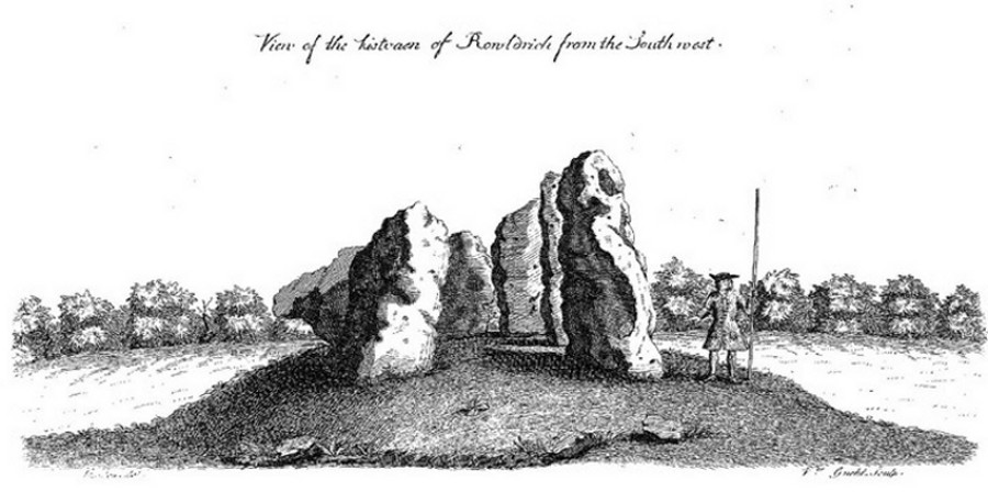
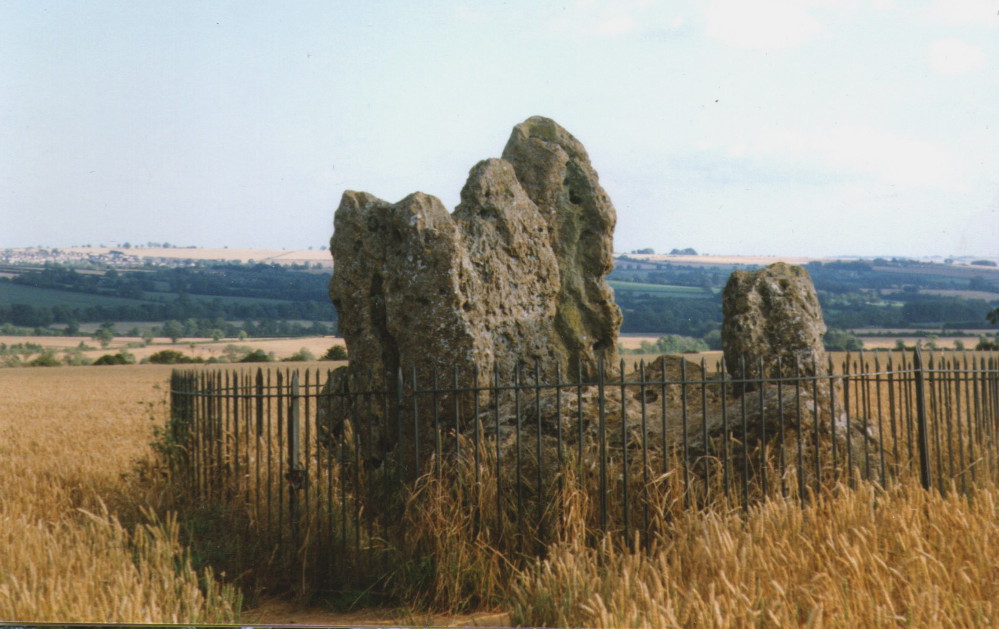
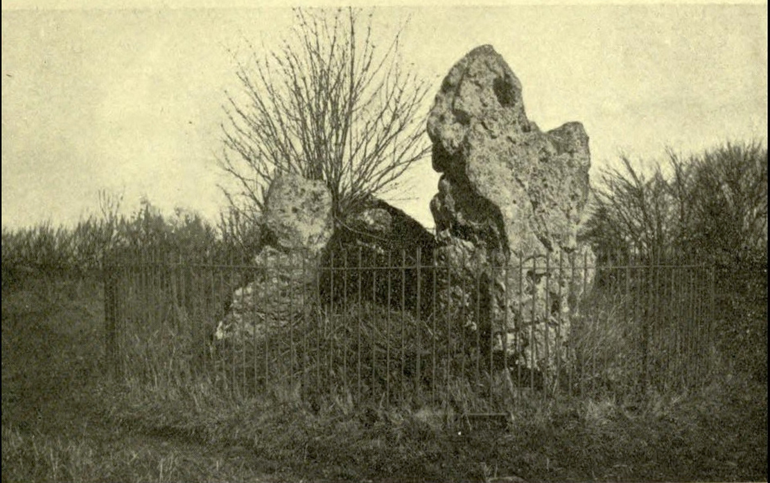
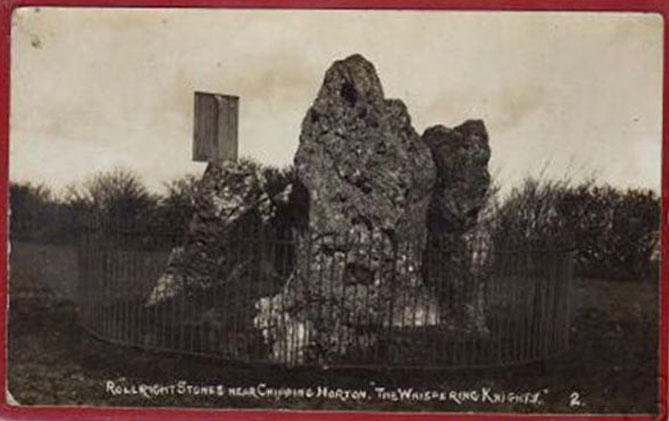
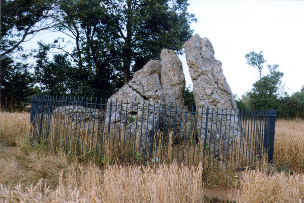
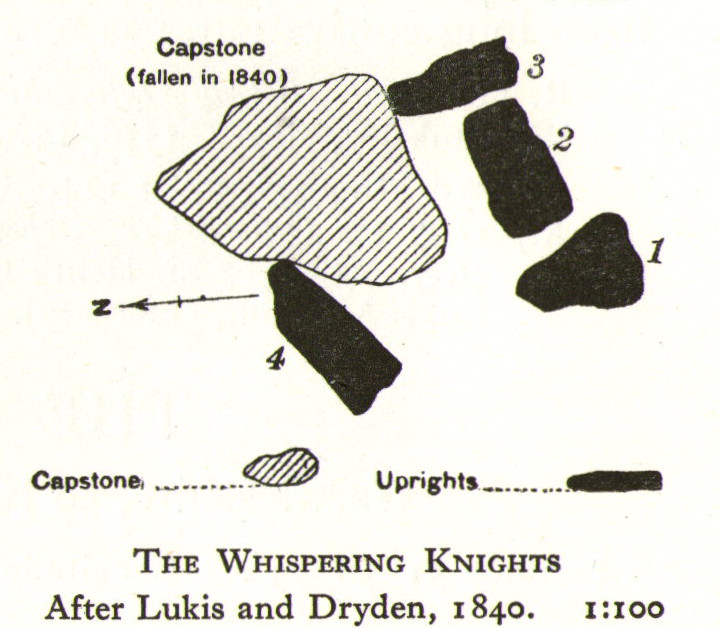
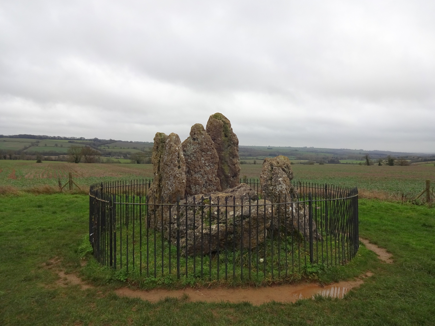
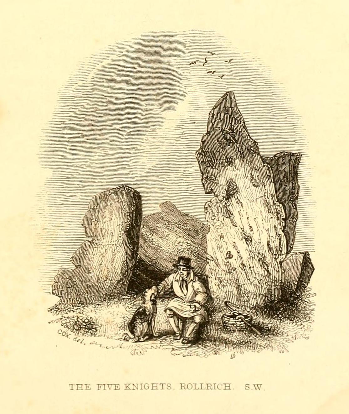
The Whispering Knights is one of the main sites in the cluster known collectively as the Rollright Stones, which also comprises of the standing stone commonly called the King Stone, plus the King’s Men stone circle a coupla hundred yards down the road from the Knights. They all sit atop of the ridge which separates the counties of Oxfordshire and Warwickshire along the edge of the prehistoric road known as the Jurassic Way. The sites are non-contemporaneous having been erected over a period of many centuries. The Whispering- or Five Knights are by far the oldest part of the complex dating from a period never previously anticipated. They comprise of four upright megaliths in close proximity, and a fifth fallen stone which is said to be the capstone on the original monument. This stone alone weighs some 10 tons.
The general archaeological opinion is that the place is a ‘portal dolmen burial chamber’ of which the capstone has fallen. The Oxford archaeologist George Lambrick (1988) postulated the stones to have been covered with a mound of earth, but any evidence supporting this has long since gone.
1920s postcard of the siteThe Knights in 1995
This great monument was initially thought by archaeologists to have been built sometime around 1800 BCE—a favourite date of academics for many an unexcavated site for many decades—until they turned their astute attention to the place in the 1980s. And what they found was astonishing. Well…astonishing for the archaeologists! Affirming the local folk tradition that the Knights were the “oldest monuments in Oxfordshire,” the dates truly went back. Way back! Datable remains at the site gave results from between 3500 and 3800 BCE: two thousand years earlier than anyone had ever expected of them.
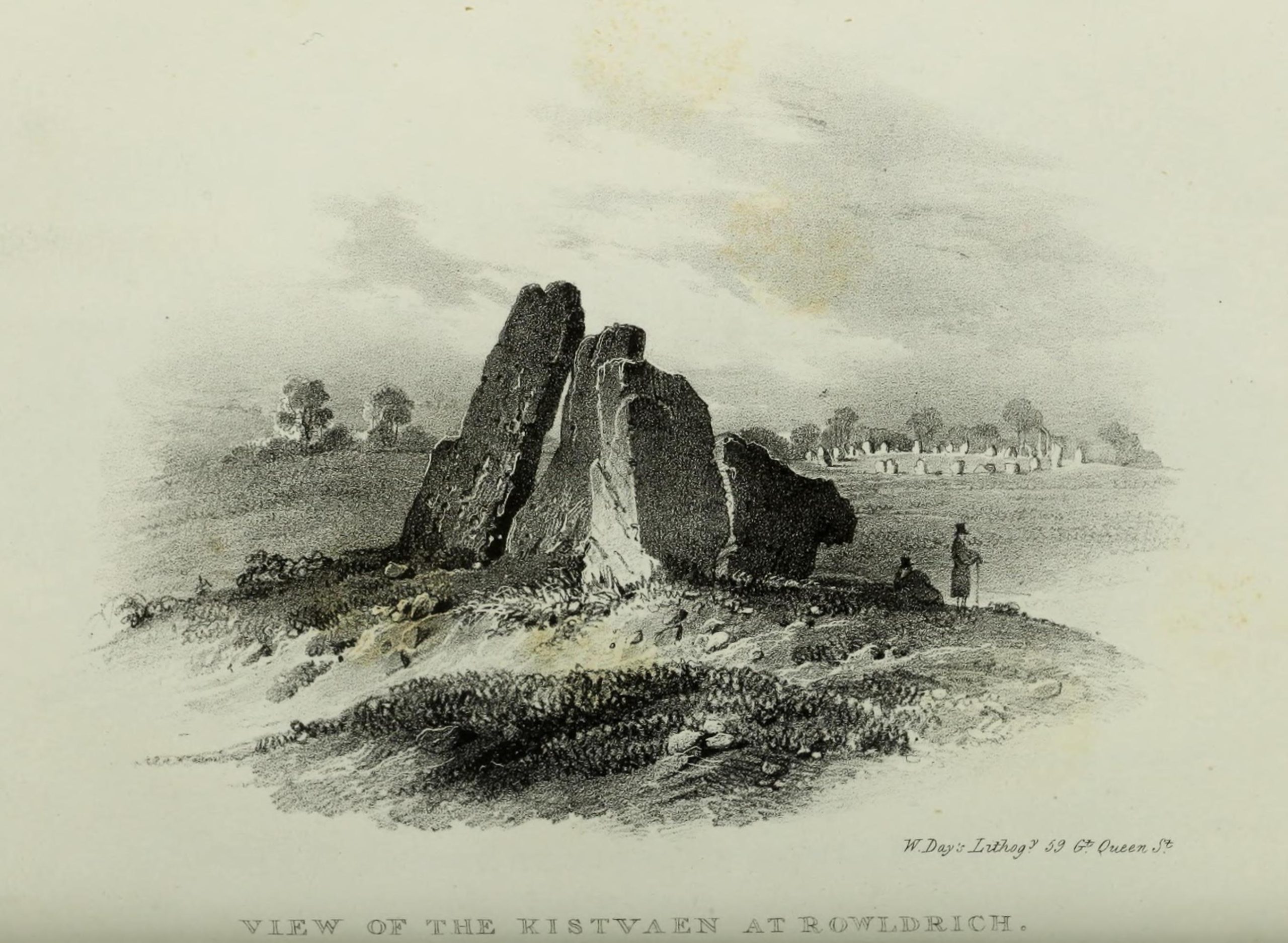
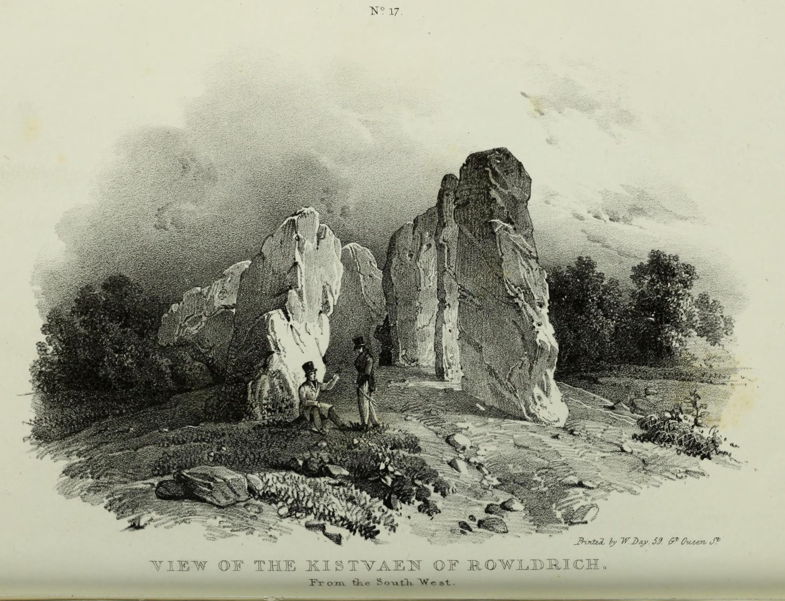
Although five stones remain of the site, when the great William Stukeley (1743) visited the Whispering Knights, he described six of them to be visible with the great stones here to be sat upon a tumulus, saying:
“Tis composed of six stones, one broader for the back part, two and two narrower for the sides, set square to the former; and above all, as a cover, a still larger. The opening is full west to the temple or Rowldrich. It stands on a round tumulus, and has a fine prospect southwestward down the valley, where the head of the Evenlode runs.”
O.G.S. Crawford (1932) told us of a description which Sir Henry Dryden gave of the Knights in 1898, when he wrote:
“About 356 yards E from the (Rollright) circle and S of the road, is the dolmen about to be described, called the Five Whispering Knights. It is in a ruinous state. It now consists of four stones, upright, or nearly so, and one prostrate, all of coarse limestone…
Height, 8ft 3ins (4ft by 2ft 6ins)
” , 7ft 3ins (3ft 6ins by 1ft 10ins)
” , 6ft 7ins (3ft 8ins by 1ft 4ins)
” , 5ft 4ins (4ft 9ins by 2ft)
Capstone (then fallen), 8ft 4ins by 5ft 9ins, by 2ft 4ins
“The chamber appears to have been about 5 feet 6 inches W and E, and the same N and S. If, as usual, there was an entrance, with or without a passage, it was probably to the ENE… There is not, so far as I know, any record of remains having been found in this dolmen. In a small stone pit about 700 feet NE by E from the circle it is stated that 12 skulls were found in 1835. In another stone pit near it was found in 1836 an urn and beads…”
1840 plan by Lukis & Dryden
During the last century, very little has really changed at the Knights. The ring fencing surrounding the stones has kept it pretty much protected, despite it ruining all sense of healthy ambience. But they have gained greater and greater attention the older they have got. Archaeologists are not the only ones exploring the site. Fascinated astronomers, engineers and architects have been and seemingly uncovered other mythic ingredients here.
Whispering Knights, 2016
When the legendary Alexander Thom came here, he used the archaeological data that was being espoused at the time, which said the Knights and the Rollright stones had both been built around 1750 to 1800 BC. With these dates as his guide, he found that someone standing at the centre of the Rollright circle, on the morning of the equinoxes—March 21 and September 21—the sun would rise right above the Whispering Knights. And the effect, he thought, was a notable one: with the light from the rising sun going straight through a hole in one of the stones in the circle as it rose up behind the Knights. It would have looked both spectacular and eerie in the rising mists of first light, like a laser cutting through the still morning air… However, although Thom’s measurements were very accurate, the archaeologists had got their dates wrong. Very wrong! For the Whispering Knights were about 1500 years older than the stone circle—and so the alignments Thom pronounced, based on the archaeologist’s erroneous proclamations, were also incorrect.
There may be other alignments connected to the Rollright complex. In a survey of the site as part of the Dragon Project experiments conducted here in June 1980, Leslie Banks and Christopher Stanley flew over the place and found, adjacent to the Whispering Knights, a quite distinct “trace of two dark green parallel lines in a field of ripening corn” running northwest to the roadside. To this day nobody quite understands the nature of this enigmatic alignment:
“In the absence of excavation we can only speculate,” said Stanley. “But the most likely explanation is that it is what archaeologists refer to as a Cursus. Cursuses are thought to be prehistoric religious processional ways.”
As with many of the alignments described here, the jury is still out on this one!
Folklore
Whispering Knights, 1829
The folklore here is prodigious! The prime story of the neolithic tomb of the Whispering Knights tells that originally they were in fact a group of traitors who moved away from a King and his army in ages past, and who were plotting against him, when the great Witch of Rollright (a southern version of the great cailleach, found in more northern counties, Scotland and Ireland) turned them all to stone (this tale is intimately bound up with the King’s Men stone circle and the associated King Stone).
Whispering Knights, 1841
Another tale tells how the King Stone and the Whispering Knights venture, at midnight, less than half a mile south to drink from a spring in the small woodland at Little Rollright Spinney, although it is difficult to ascertain precisely which of the two springs the stones are supposed to visit. In some accounts, the stones reputedly drink from the well every night, but others tell that they only go there at certain times of the year, or on saint’s days. When Arthur Evans (1895) wrote of these tales he described there being a “gap in the bushes… through which they go down to the water,” but the terrain has altered since his day.
Other accounts imbuing the stones with life tell how they only ‘awaken’ when disturbed by humans. A story well-known to local people is that of when the Knights had its capstone removed one day by a farmer who used it to build a bridge across the stream at Little Rollright. As Evans told us,
“it took a score of horses to drag it down the hill, for at first it would not move, and they had to strain and strain to get it along till every bit of the harness was broken. At last they got it to the brook by Rollright Farm, and with great difficulty laid it across to serve as a bridge. But every night the stone turned over back again and was found in the morning lying on the grass.”
Three nights of this led the farmer to think he should replace the stone which, so the fable goes, took only one horse to move it back uphill and into position. A variation of the same tale was told by T.H. Ravenhill, who wrote:
“The Lord of the Manor of Little Rollright desired to possess the King’s Stone in order to bridge Little Rollright brook. So he dug it up and tried to cart it away, but found that he had not enough horses. He hitched on more, and yet more, and still he found that he could not move the stone. Finally he succeeded and hauled the stone away to the Manor House. The same night he was alarmed by strange sounds about the house, which he attributed to the presence of the King’s Stone, and decided, therefore, to replace it on its mound. No sooner had he harnessed the first horse to the cart than it galloped away up hill with ease, taking with it the stone, which leapt to position on reaching its resting place.”
There are still more variations that are worth mentioning. One from 1876,
“said that a miller in Long Compton, thinking the stone would be useful in damming the water of his mill, carried it away and used it for that purpose, but he found that whatever water was dammed up in the day disappeared in the night, and thinking it was done by the witches (at Long Compton) and that they would punish him for his impertinence in removing the stone, he took it back again; and, though it required three horses to take it to Long Compton, one easily brought it back.”
In yet another version, the stone was wanted by a local farmer for his outhouse. In taking it downhill, the horses that pulled his wagon died and the vehicle itself was irreparably damaged. It got even worse for the poor chap: his crops failed, his family were taken ill and his cattle died. Eventually when all but his last horse remained, he made another cart and it pulled the stone back uphill with ease. Thereafter, so the tale goes, all his adversities stopped and he lived a normal life. In one version of this tale, the great monolith was said to have been taken north-north-west down to the stream at The Hollows, Long Compton. Tales such as these are, once more, found throughout the world.
The truth of these stories was seemingly unquestionable to some local people in the 19th century,
“one man going as far as to say that there were those now living who had spoken to men who had helped to bring the stone down and up again.”
In William Stukeley’s day, one Farmer Baker was so troubled by his actions that he couldn’t rest until he returned the old stone.
The doyen of the early geodelic sciences or Earth Mysteries movement, John Michell, suggested how the legends of megaliths moving of their own accord harked back to ancient days when the people of those times were more attuned to the terrestrial magnetic flows of the Earth.
The Whispering Knights were also a place where “young girls of the neighbourhood (use it as) a kind of primitive oracle.” One local told Arthur Evans that around barley harvest the young women of the district visited the Five Knights to listen to them whisper. One at a time they would rest their ears against the strange shapes of stone and, if fortune and conditions were right, they would hear the future told. This mass of animistic lore is very revealing indeed, telling us much about the way our peasant ancestors viewed the living world around them. (Eliade 1958)
In more recent times, the site has been explored by dowsers and ley hunters, who claim to have found a veritable bags of fascinating lost material around the Knights. Although originally ‘leys’ were described by Alfred Watkins as quite acceptable prehistoric trackways linking site to site to site, in recent years the original theory has been ignored and superceded with a host of almost incredulous fluctuations. Leys these days can run just about anywhere – and do!
One writer who tells about the leys around Whispering Knights is Lawrence Main. (1997) He dowsed and found a ley running south to the famous White Horse at Uffington. Roy Cooper (1979) was the first person to write about this alignment and extended it further north to the impressive and legendary Brailles Hill. That one seems reasonable. However,
“Other leys I dowsed,” said Main, “Linked the King Stone, the stone circle, and the Whispering Knights with each other; the King Stone with Banbury Cross; the Whispering Knights with Hook Norton church; and the stone circle with the churches at Todenham and Stretton-on-Fosse.”
Another dowsing ley hunter is Dennis Wheatley (not The Devil Rides Out dood). He wrote a couple of short works on his lengthy experiments at the Rollright stones and reported how he found a
“tangential aerial energy course…across the country (which) latches on to a solitary standing stone, six miles south, known as the Hawk Stone.”
Perhaps of greater importance here is that Wheatley also discovered how,
“all of the Rollright ring’s stones engage in aerial energetic cross-talk with the King Stone producing a triangulation of energy lines.”
This cross-talk of Wheatley’s involves more than seventy energy lines running between the circle and the King’s Stone. He tells us that a greater “aerial cross-talk” also occurs between the circle and the Knights; and “a lesser energetic triangulation” runs between the King and the Knights.
Along similar lines are the findings of the dowser Reginald Smith. (1980) Beneath the Whispering Knights he claimed to have found,
“a concealed spring which runs underground to the northwest and may betoken a consecrated site; but 100 feet to the east there seems to be another blind spring with issue to the northeast.”
References:
Bennett, Paul & Wilson, Tom, The Old Stones of Rollright and District, Cockley Press: London 1999.
Burl, Aubrey, Great Stone Circles, Yale University Press: New York & London 1999.
Cooper, Roy, ‘Some Oxfordshire Leys,’ in The Ley Hunter 86, 1979.
Crawford, O.G.S., Long Barrows of the Cotswolds, John Bellows: Oxford 1932.
Devereux, Paul, Places of Power, Blandford: London 1990.
Devereux, Paul, The Sacred Place, Cassell: London 2000.
Eliade, Mircea, Patterns in Comparative Religion, Sheed & Ward: London 1958.
Evans, Arthur J., ‘The Rollright Stones and their Folklore (3 parts),’ in Folklore Journal, 1895.
Gelling, Margaret, The Place-Names of Oxfordshire – volume 2, Cambridge University Press 1971.
Graves, Tom, Dowsing: Techniques and Applications, Turnstone: London 1976.
Grinsell, Leslie V., The Ancient Burial Mounds of England, Methuen: London 1936.
Lambrick, George, The Rollright Stones: The Archaeology and Folklore of the Stones and their Surroundings, Oxford Archaeology Review 1983. (Reprinted and updated in 1988.)
Main, Lawrence, Walks in Mysterious Oxfordshire, Sigma: Wilmslow 1997.
Ravenhill, T.H., The Rollright Stones and the Men Who Erected Them, Little Rollright 1926.
Robins, Don, Circles of Silence, Souvenir Press: London 1985.
Smith, Reginald A., ‘Archaeological Dowsing,’ in Graves, Tom (ed.), Dowsing and Archaeology (Turnstone: Wellingborough 1980).
Stanley, Christopher C., ‘A Rollright Processional Way?’ in The Ley Hunter 90, 1981.
Stuart, Sheila, Lifting the Latch, Oxford University Press 1987.
Although ascribed as a wooden ‘henge’ by archaeologist Jean Cook, the site is more accurately a simple timber circle. Cook (1985) described this little-known “Wood Henge” monument, as she called it, sat inside the lower southeastern end of the impressive Dorchester Cursus monument. The site was obviously of some ritual importance, for a variety of reasons. It was excavated in 1981 and,
“it consisted of a ring of large pits enclosing an area some 18m in diameter. The site was situated along the central axis of the (Dorchester) cursus, presumably influenced by the alignment. The pits, which varied in size, had each contained a wooden post, in three instances consisting of an entire trunk of an oak tree. All the posts were burnt in situ, presumably during some form of destruction ceremony.”
Groundplan of site
When Alex Gibson came here a few years afterwards to re-examine the site, his work and that of Richard Bradley (1988) also found the place to have been an elliptical ‘ring’ of once-upright timber posts. Although Gibson (1998) later gave a confused version of where the site actually was (wrong grid-refs), his brief description gave us an outline of what was once here:
“An oval of 12 postholes containing the carbonized remains of 13 posts which had been burnt prior to the placing of cremations in the upper fills of the postholes. The SW posthole contained the remains of two posts in the same socket. There is a possible entranceway, marked by a wider gap between posts, in the NW.”
But this last line appears to be pure speculation. I’ve not read the longer archaeological accounts of this ‘wood henge’ and adjacent sites (Bradley & Chambers, 1988; Gibson 1992), which should give greater details about the site as a whole. The Pastscape site gives the following information:
“A pit circle comprising a sub-circular arrangement of 12 pits was excavated in the early 1980s in advance of work on the Dorchester by-pass. The site lay within the Dorchester Cursus (SU 59 NE 5), circa 400 metres northwest of its southeastern terminal. The long axis of the pit circle was the same as that of the cursus. Each of the pits had held a timber upright, and some if not all had been burnt in situ. An air photograph of the site had suggested the presence of a central pit but this feature proved to be a natural pocket of sand. Six deposits of cremated bone came from various post pipes. Other finds included a handful of potsherds, one possibly of Early Bronze Age date, some animal bone fragments, and a few flints. Radiocarbon dates from cremated bone and charcoal centred on the mid 3rd millennium BC, with one slightly later.”
References:
Bradley, R. & Chambers, R., “A New Study of the Cursus Complex at Dorchester-on-Thames, in Oxford Journal of Archaeology, volume 7, 1988.
Cook, Jean, “The Earliest Evidence,” in Dorchester through the Ages, Oxford University 1985.
Cook, Jean & Rowley, Trevor (eds.), Dorchester through the Ages, Oxford University 1985.
Gibson, Alex, “Possible Timber Circles at Dorchester-on-Thames,” in Oxford Journal of Archaeology, volume 11, 1992.
Gibson, Alex, Stonehenge and Timber Circles, Tempus: Stroud 1998.
Pennick, Nigel & Devereux, Paul, Lines on the Landscape, Hale: London 1989.
Very close to the once impressive Dorchester Cursus, this double-ringed prehistoric monument can no longer be seen thanks to the self-righteous arrogance of modern industrialists who care little for the ancestral monuments of the British people, destroying all traces of the site — an activity which, in this case, astonishingly started in more ancient times, as Jean Cook (1985) told: “The banks and the ditches had been levelled through agricultural activity, possibly in the Iron Age”!
Big Rings ground-plan1938 photo of the Big Rings, by Major George Allen
The destruction of this environment continues to this day, destroying many important archaeological remains with little care. Thankfully we we’ve got a good account of the site due to the archaeological excavations of R.J.C. Atkinson (1951) and his team in the late-1940s, from whom Cook and just about everyone else gets most of their data regarding the site.
The Big Rings Henge was probably built sometime in the middle of the second millenium BC. It was an important prehistoric ritual site and, most likely, had some relevance to the adjacent cursus monument. A number of important mortuary and ritual sites were also built close to the site over a period of nearly two thousand years, showing the importance this landscape had to our ancestors.
Jean Cook (1985) described the Big Rings henge as follows:
“The ditches, of which there were two, had opposed entrances on the NNW and SSE. They were about 7.6m wide and 1.8m deep with flat bottoms. Originally there seems to have been a broad low bank on the inner side of each ditch. The southern entrance incorporated an existing monument, consisting of a ring ditch which enclosed a large four-post setting and contained a cremation and a stone axe. Just outside the north entrance was a round barrow, containing a central oval burial pit which produced a crouched inhumation, together with a well-preserved beaker, two small copper or bronze knives and a rectangular wrist-guard of greenstone. The Big Rings ditches themselves contained pottery belonging to the middle or late Beaker period. Although the area within the ditches was trenched, there was no evidence of internal timber structures.”
References:
Atkinson, R.J.C., “The Henge Monuments of Great Britain,” in Atkinson, Piggott & Sandars’ Excavations at Dorchester, Oxon (Department of Antiquities: Oxford 1951).
Atkinson, R.J.C., Piggott, C.M. & Sandars, N.K., Excavations at Dorchester, Oxon, Department of Antiquities: Oxford 1951.
Cook, Jean, “The Earliest Evidence,” in Dorchester through the Ages, Oxford University 1985.
Harding, A.F., Henge Monuments and Related Sites of Great Britain, BAR 175: Oxford 1987.
Harding, Jan, The Henge Monuments of the British Isles, Tempus: Stroud 2003.
Wainwright, Geoffrey J., The Henge Monuments: Ceremony and Society in Prehistoric Britain, Thames & Hudson: London 1989.
The site has been known about for nearly 150 years, albeit mistakenly as a series of prehistoric barrows that William Greenwell (1877) told were “near the division between the parishes of Rudston and Burton Agnes” near the crest of the hill. He further told the place to be,
“Two long mounds, almost parallel, their northern end gradually losing themselves in the surface-level, but connected together at the southern end by another long mound.”
South end of Cursus A (after D.P. Dymond)Early photo of Cursus A (after J.K.St Joseph)
Then in 1958 when C. & E. Grantham of Driffield did the first modern excavation here across a section of the western ditch, they found that the long embankment went on much further than ever previously anticipated, for more than half-a-mile downhill in the direction of Rudston village. It wasn’t a long barrow or tombs of any sort, they found! Then in 1961 when Dr. J.K. St. Joseph did aerial survey work over the area, he and his colleagues established that this monument consisted of extensive parallel ditches stretching for at least 1½ miles towards and past the eastern side of Rudston village. It’s nature as a cursus monument was rediscovered after several thousand years in the wilderness… (on St. Joseph’s survey, two other cursus monuments were also found in the vicinity, being Rudston Cursus B and Cursus C) Readers will hopefully forgive me for quoting at some length Mr Dymond’s (1966) article on the site (with minimal editing!):
“The southern end of the cursus lies in the western angle of two roads, Woldgate and Burton Agnes Balk. In plan it is square with rounded corners and consists of a bank with outer ditch. Although the bank has been ploughed for many years, it still remains substantial; it stands up to 4 feet high from the outside and 1-2 feet wide from the inside. The east and west banks decline in height northwards and are now at their greatest height where they join the southern end. The profile of each bank is smooth and rounded and merges on the outside with the broad shallow depression of the silted-up ditch. The south bank is now 170 feet long overall, and spread to a width of 60-80 feet. It stands higher at both ends than in the middle. This fact was noted by Greenwell, who also recorded that at the southwest angle “there was the appearance of a round barrow raised upon the surface of the long mound.” There is no surface evidence today to suggest a secondary round barrow, and to some extent at least the greater height at the angles is probably due to the concentration of upcast inside a fairly sharp corner.
“The south arm of the ditch has been largely destroyed by a chalk-pit, but the southeast turn is quite clear on air-photographs. There is no suggestion on the ground or from the air that the cursus had ever extended further to the south.
“The cursus begins its descent in a due northerly direction, and loses its eastern side for approximately 600 feet under the enclosure road, Burton Agnes Balk. The ditch can be traced intermittently on the western and eastern verges. It then swings gently NNW around the head of a small slack draining northwest. Thus far the cursus is traceable on the ground. The ditches are the most consistent feature, showing as broad shallow depressions 20-40 feet wide and 70-80 yards apart, which when in fallow attract a dark coarse vegetation (particularly thistles and nettles. The banks inside the ditches are sometimes visible in relief though considerably spread. Where the banks have been almost entirely ploughed out, a chalk spread usually marks their position.
“There is a suggestion on the ground that the banks and ditches may have been separated by berms, particularly on the east side near the square end. This appears to be confirmed by the silting of the ditch in the excavated section…
“Proceeding further downhill in the direction of Rudston village, the cursus quite suddenly swings north-NNE, finally crosses Burton Agnes Balk, and passes to the west of Pits Plantation. On the west of the road both banks and ditches are still visible in relief, and the ditches produce a firm crop-mark. East of the road no surface traces are discernible, and only the eastern ditch shows intermittently as a crop-mark.
“For ½-mile across the floor of the Great Wold Valley, there is no trace of the cursus. The area has been ploughed since medieval times, and there is in addition a considerable Romano-British settlement. It is worth noting that in this length, the cursus must have crossed the stream of the Gypsey Race, surely a fact of some importance in any discussion of the function of cursuses.
“Two parallel ditches c.60 yards apart, visible on air photographs in a field immediately north of the modern Rudston-Bridlington road, seem to represent the continuation of the cursus. The ditches travel for approximately 300 yards and end at the Bridlington Gate Plantation. There are no surface traces in the field, but a depression in the plantation may represent the eastern ditch. This depression is crossed obliquely by the remains of a low bank and ditch running along the length of the plantation WSW and ENE. This latter (part) is probably part of the supposedly Iron Age entrenchment system, and has certainly been used as a road from Rudston to Bridlington, as the name of the plantation implies.
“The northern end of the cursus cannot be traced. Possibilities are that the end was in the plantation and has been destroyed by the later earthwork, or that the cursus proceeded NNE for an unknown distance. If the latter hypothesis is accepted, the western ditch must be under the Argam Dykes, a double entrenchment which appears to terminate at the northern side of the plantation, and the eastern ditch is indistinguishable from ploughing lines to which it is parallel…
“Cursus A has its southern end at a height of 254 feet OD, on the forward face of a long chalk ridge running WSW and ENE. From this point the course of the cursus is visible, except for that part west of Pits Plantation. The last known part in Bridlington Gate Plantation, 1½ miles off, is clearly visible. Seen against the contours of the area, the cursus has one end resting on a high ridge, crosses a broad valley, and climbs at least in part, the far side. It appears to pass approximately 300 yards east of the monolith in Rudston churchyard.”
Line of Rudston A
The presence of this and three other cursus monuments close by (Rudston B, C and D) indicates that the region was an exceptionally important one in the cosmology of our prehistoric ancestors. Four of these giant linear cursus monuments occur in relative proximity, and there was an excess of ancient tombs and, of course, we have the largest standing stone in the British Isles stood in the middle of it all. A full multidisciplinary analysis of the antiquities in this region is long overdue. To our ancestors, the mythic terrain and emergent monuments hereby related to each other symbiotically, as both primary aspects (natural) and epiphenomena (man-made) of terra mater: a relationship well known to students of comparative religion and anthropology who understand the socio-organic animistic relationship of landscape, tribal groups and monuments.
References:
Dymond, D.P., “Ritual Monuments at Rudston, E. Yorkshire, England,” in Proceedings of the Prehistoric Society, volume 32, 1966.
Eliade, Mircea, The Sacred and the Profane, Harvest: New York 1959.
Greenwell, William, British Barrows, Clarendon Press: Oxford 1877.
Hedges, John & Buckley, David G., The Springfield Cursus and the Cursus Problem, Essex County Council 1981.
Nicholson, John, Beacons of East Yorkshire, A. Brown & Sons: Hull 1887.
Pennick, Nigel & Devereux, Paul, Lines on the Landscape, Hale: London 1989.
One of the four (known) cursus monuments around Rudston: this one stretches between the Ordnance Survey coordinates TA 081669 near Kilham Grange on the southwestern edge of Rudston, then heads northeast towards the village itself at TA 094675. Described briefly in D.P.Dymond’s essay on (mainly) Cursus A, he said how Cursus B was part of,
Early ground-plan (after D.P. Dymond)Early photo of Rudston B (after J.K.St Joseph)
“a large complex of crop marks. The largest feature is the squared, tapering end of Cursus B, which can be traced for 700 yards in a north-easterly direction. No surface remains seem to survive in an area intensively ploughed, except for a swelling under a hedge on the line of the south-eastern bank (at TA 0834 6703). West of the square end and partly overlying it, are several small rectangular enclosures, which are probably part of a later (?Romano-British) settlement and field-system. Also in this tangle of crop-marks there are four roughly circular shapes, which may well be barrow circles associated with the end of the cursus. On certain barrow just south of the end of the cursus has an inner ring of pits. Where the cursus is lat visible to the north-east, it is headed roughly for the monolith ¾-mile away. The width of Cursus B is approximately 90 yards between ditch centres. It has its square end on the forward slope of a ridge (like Cursus A) at a height of 180 feet OD, and descends towards the village, which is visible from the end, through a shallow valley.”
Dymond’s note about the alignment feature of this cursus, towards the gigantic Rudston monolith, was one echoed in the Hedges & Buckley (1981) survey. They noted:
“At Rudston, the B cursus extended eastwards aligns upon the Rudston monolith in Rudston churchyard. Destruction of standing stones elsewhere may have removed similar associations between the stones and cursuses.”
This alignment feature was also confirmed by cognitive archaeologist and alignment specialist, Paul Devereux (Pennick & Devereux 1989) in his survey of cursus monuments.
Typical of these fascinating antiquities, nothing of any worth has been found along the length of the cursus that can give us any clues to its nature and function. However, the presence of this and three others close by indicates that the region was an exceptionally important one in the cosmology of our prehistoric ancestors. Four of these giant linear cursus monuments occur in relative proximity, and there was an excess of ancient tombs and, of course, we have the largest standing stone in the British Isles stood in the middle of it all. A full multidisciplinary analysis of the antiquities in this region is long overdue. To our ancestors, the mythic terrain and emergent monuments hereby related to each other symbiotically, as both primary aspects (natural) and epiphenomena (man-made) of terra mater: a phenomenon long known to comparative religious students and anthropologists exploring the animistic natural relationship of landscape, tribal groups and monuments.
References:
Dymond, D.P., “Ritual Monuments at Rudston, E. Yorkshire, England,” in Proceedings of the Prehistoric Society, volume 32, 1966.
Eliade, Mircea, The Sacred and the Profane, Harvest: New York 1959.
Hedges, John & Buckley, David G., The Springfield Cursus and the Cursus Problem, Essex County Council 1981.
Pennick, Nigel & Devereux, Paul, Lines on the Landscape, Hale: London 1989.
Destroyed by the usual mixture of intensive farming practices and the self-righteous advance of industrialism, this cursus of many names was discovered thanks to aerial survey photographs taken in the early 1960s. Found only 6½ miles west of the Aston Cursus and constructed on level ground on the north side of the River Trent next to B5009 road between Twyford village and Willington. I think the site was first described by J.K. St. Joseph (1966) in his notes on air reconnaissance finds, in which he described the site,
“So far the parallel ditches, some 220ft apart, defining the cursus have been identified on an east to west alignment across three fields for a length of some 1800ft. This may well be only fraction of the total length of the monument, which probably extended westwards towards the new power station at Willington. Three ring-ditches, one lying within the cursus, and two to the north, as well as a rectangular enclosure, have also been recorded.”
There was probably more to be discovered here, he thought. And so the following year the first dig into one section of the site was made, and again in 1969. A synopsis of this and subsequent excavation work have been reported on the PastScape website which tells:
“The cursus has been traced for a distance of at least 1560 metres, lying near the edge of the flood-plain of the Trent. Excavations in 1994-5 in advance of work on a bypass recovered Peterborough Ware sherds close to the bottom of the southern cursus ditch. Charred organic remains were also present, from which radiocarbon dates are to be sought. The excavations also uncovered a causeway between 10.5 and 19 metres in length through the northern ditch. Within this causeway were a cluster of short linear features and a post hole, all presumably evidence for controlling access into the monument. Another break in the northern ditch was shown to have been created to accommodate the course of a stream, which still runs through it. The 1994-5 excavations also confirmed that the 1969 excavations had in fact found a series of natural features which were mistakenly interpreted as representing the cursus ditches… At the south-western limit of the cursus cropmarks the southern ditch appears to have been recut and possibly reused at a later stage as a double ditched trackway…”
References:
St. Joseph, J.K., “Air Reconnaissance: Recent Result, 6,” in Antiquity journal, volume 40, no.157, March 1966.
Wheeler, Hazel, “The Findern Cursus,” in Derbyshire Archaeological Journal, volume 90, 1970.
Running roughly north-to-south, this cursus was 2¼ miles long (3600 metres) and comprised of two linear sections from a field in Stanwell up through the western side of Heathrow Airport averaging, curiously, just 24 yards (22m) across. Of course nothing of it can be seen today as the airport and surrounding industrial crap has destroyed it. The cursus had a lengthy internal bank along its length. During excavation work done at the Perry Oaks Sludge Works section in Hillingdon, archaeologists found evidence for a short avenue of posts, about 110 feet long, apparently constructed prior to the cutting of the cursus’ ditches, following the same direction/alignment of the subsequent monument. In Roy Loveday’s (2006) survey of cursus monuments he said this of Heathrow’s cursus:
“This site, striking across land so flat that it has been selected for Heathrow Airport, extends for some 4km, crosses two rivers and stops by a stream — originally perhaps a more major river. So straight and apparently narrow is it (20m) that it was originally taken to be a Roman road. Early excavation seemed to support the idea: vestigal remains areas of gravel between the ditches were scored by shallow gullies resembling cart ruts. Later excavation, however, demonstrated that the ditches of a Late Bronze Age field system cut across it and several scarps of Peterborough Ware (i.e., pottery – PB) were recovered from its ditches. Evidence also emerged of a short (50m) ragged, double row of posts, removed before the ditches were dug on the same alignment. That this was a bank barrow was hinted at by the Charlecote test and by reduction in the depth of field ditches as they crossed the central area.”
Confirmation that an earthen bank of some kind running near the middle of the cursus was confirmed by analysis of early Ministry of Defence aerial photographs. For those who would like a more detailed description on this site, I refer you to the excellent paper by o’ Connell. (1990)
…to be continued…
References:
Barclay, Alistair, et al, Lines in the Landscape, Oxford Archaeological Unit 2003.
Loveday, Roy, Inscribed Across the Landscape, Tempus: Stroud 2006.
o’ Connell, M., “The Heathrow-Stanwell Cursus,” in Current Archaeology, 9, 1986.
o’ Connell, M., “Excavations during 1979-1985 of a Multi-Period Site at Stanwell,” in Surrey Archaeological Collections, 80, 1990.