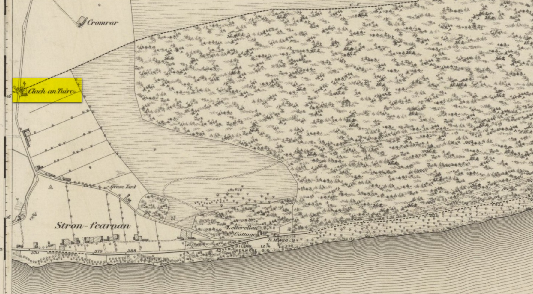
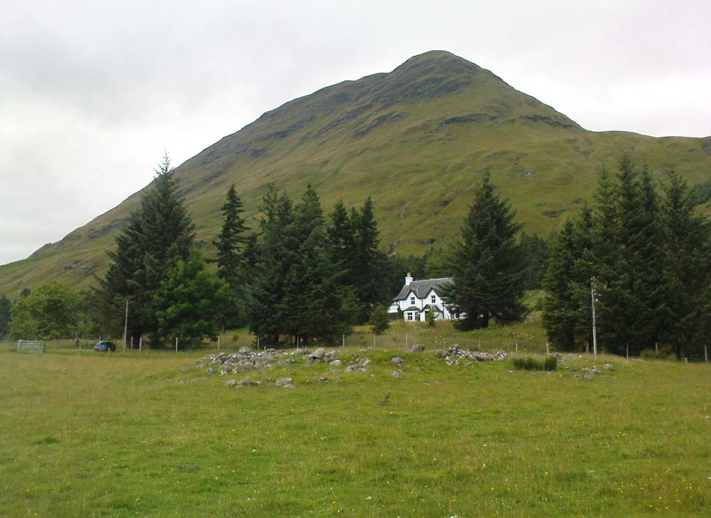
Pretty easy to find unless the vegetation takes over! From Fearnan take the road to Fortingall. Just as you’re going out of Fearnan, in the walling by the very last house on the right-hand side of the road is this large earthfast boulder. Y’ can’t miss it!
Archaeology & History
I first visited the Clach an Tuirc – or the Boar’s Stone – in 1981 when I stayed at Fearnan for a few weeks and, after clambering on top, looked down on the several simple cupmarks. Forty years later, I returned with a camera!
First highlighted on the 1862 OS-map, Fred Coles (1910) made a brief note of the petroglyph in one of his megalithic surveys, but only noticed a single cup, saying:
“Near Cromraor, close to the cottage at Clash na Tuirc, stands the large boulder bearing that name, the Boar Stone. Its highest point is about six feet above the road, and bears one very distinct cup-mark.”
But there are several cup-markings on top of the stone, just as William Gillies (1938) described.
Folklore
Not far from here tradition tells of a legendary figure who is known today only as the Lady of Lawers (whom tradition asserts to have been a member of the Stewart family, from Appin, Argyll – they of the daemonic Red Book of Appin). She made various prophecies, one of which said “that when Clach an Tuirc, the Boar’s Stone at Fearnan, would topple over, a strange heir would come to Balloch.” Though as the stone still aint toppled, we’re still waiting… (let’s just hope this doesn’t augur more of those selfish tories into our mountains who bring with them their mantras of “gerrof mah land”)
References:
Coles, Fred, “Report on Stone Circles Surveyed in Perthshire (Aberfeldy District),” in Proceedings Society Antiquaries, Scotland, volume 44, 1910.
Gillies, William A., In Famed Breadalbane, Munro Press: Perth 1938.
MacMillan, Hugh, ‘Notice of Two Boulders having Rain-Filled Cavities on the Shores of Loch Tay, Formerly Associated with the Cure of Disease,’ in PSAS 18, 1884. ???
Yellowlees, Walter, Cupmarked Stones in Strathtay, Scotland Magazine: Edinburgh 2004.
Acknowledgements: Huge thanks for use of the 1st edition OS-map in this site profile, Reproduced with the kind permission of the National Library of Scotland.
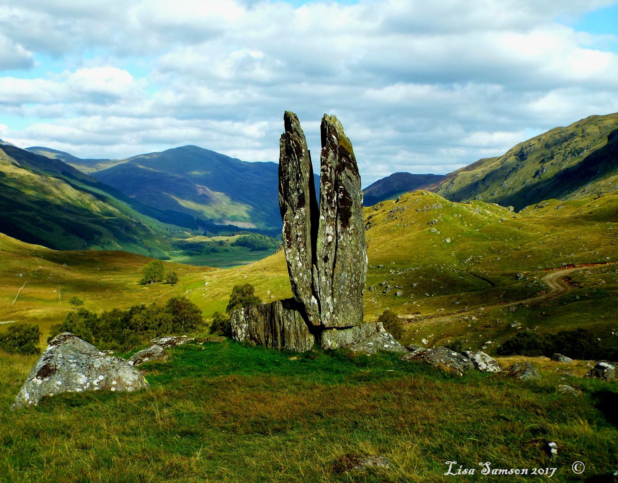
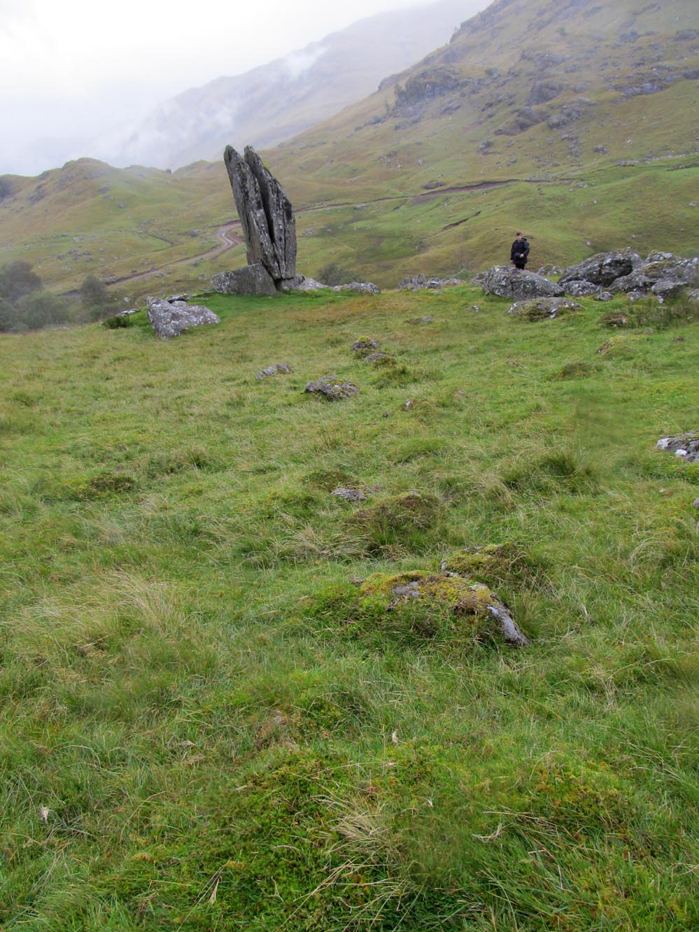
Clach na Sgoltadh, Glen Lyon (photo – Lisa Samson)
From Fortingall take the road into the legendary Glen Lyon. About 8 miles along, a short distance past the Adamnan’s Cross standing stone, you reach the tiny hamlet of Camusvrachan. On your left is a singular dirt-track, past some cottages. Go along here and over the river bridge until you reach the junction on the other side. From here, turn right and a half-mile on when you reach the farm and manor-house on your right, park up. From here you’ll see a track going uphill. Walk straight up and after a half-mile or so, keep your eyes peeled to your right. You cannot fail to see this impressive giant on the slopes above you!
Archaeology & History
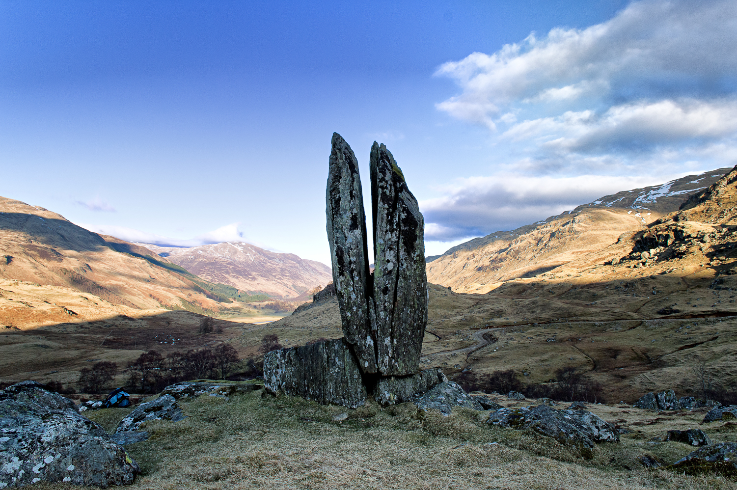
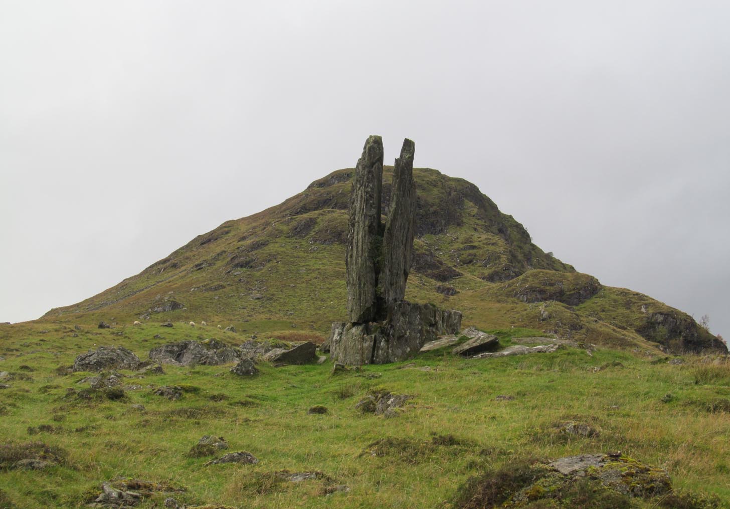
This is a truly mighty monolith! — a beauty no less! Standing upon a rocky ridge nearly halfway along the glen, the landscape it looks across is, without doubt, some of the finest in the British Isles. To our ancestors who, until just two hundred years ago peopled this and nearby glens in great numbers, this great stone would have been well known and had old myths told of it. Today we have only bare fragments.
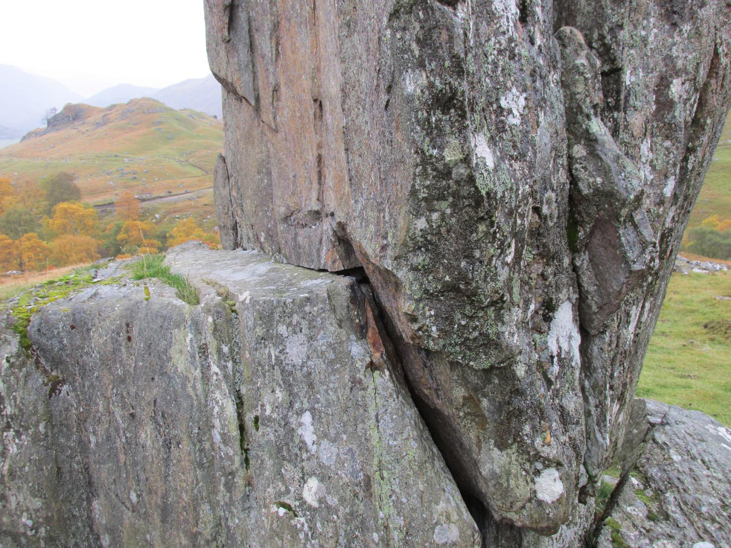
To give an ‘archaeological survey’ of any kind to this site would seem somewhat of an anathema, as it is generally deemed to be little other than one of Nature’s incredible creations. We’ll come to that in a minute. But what is quite certain is that a line of very old and very low-lying walling runs from up the slope and almost straight down to Clach na Sgoltadh. You can see it pretty clearly in the photograph below. The walling stops at the giant stone and continues no further downhill from the other side of the giant upright.
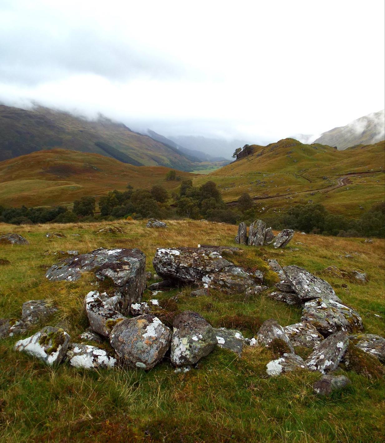
Walk diagonally down the slope about 30 yards south-east from the stone and you’ll find a small but distinctly man-made ring of stones, low to the ground, with an entrance on its northeastern side. It’s somewhat of a puzzle as it’s too small for a hut circle (I laid down in it in various ways and found you’d have to lie foetal all night if you were to use it as your own little abode), and it equally too small as an animal pen – unless it was for just one animal, which is most unlikely. The small circular construction wouldn’t seem to be prehistoric, but it would be good to know what it is.
So, we do have some very slight archaeological association with the site, albeit minimal, with the very ancient walling that leads to the stone being the most intriguing.
Small stone ‘hut’Low line of walling
The stone is generally attributed to be a geological creation. I certainly cannot say, as I have no expertise in the subject. However, in the opinion of just about everyone with whom I’ve visited this stone, I seem to be the only one who doesn’t think it’s man-made. A number of people have each insisted to me that it’s been stood upright by humans due to the quite distinct ‘squaring’ of the upright stone, particularly at the north-facing base. —and been seemingly bemused at my own lack of conviction. It does look as if it could have been cut and squared just as they all say but, let me repeat, I’m no expert at geology, and so all I can say is that I simply don’t know one way or the other. (useless prick that I am!)
“Perhaps a stone mason might know?” someone suggested—which seemed to be a good idea. Certainly a stone mason would surely be able to tell if it had been cut and dressed at the base, where it fits into the large earthfast rock….
Cue Chris Swales: a reputable stone mason from near Skipton, North Yorkshire. Chris and his friends took a week long whistle-stop tour in and around the Loch Tay region and thought they’d visit Glen Lyon. I heard about this and so asked him if he’d have the time to visit this stone giant and, if possible, let us know his opinion: is is a natural obelisk, or does it look to have been erected by humans? I told him my opinion and that of the geologists who give it an entirely natural provenance.
It was a few weeks later when he got back in touch and I asked him if he’d been up to Clach na Sgoltadh.
“I did,” he said. “it’s bloody impressive Paul. And what a gorgeous landscape too. I’d love to go there again.”
“Aye, it is Chris. And what did you think of the giant stone then? In your opinion is it man-made or natural?”
“Well I don’t know for certain Paul,” he said, “but in my opinion I’m 95% sure that it’s man-made.” He said it plain as day, just like a typical daan-to-Earth Yorkshireman. Chris isn’t into any the energy ley-line stuff, so his words carry more weight than those who wanna spice-up a site by projecting their own beliefs onto a place. As a result, I was somewhat taken aback by his words.
“What—are you sure Chris?!” I asked.
Cut & dressed stone?
“Like I said – I’m not 100% sure Paul. I can’t really say it 100% – but I’m 95% certain that people cut and dressed the base of that stone and put it there. If it’s natural, then I’d like to know how they think that’s the case. I’m willing to be shown otherwise, but in my opinion, on the whole, it’s man-made. People stuck that stone there!”
It would be great to get another stone mason’s opinion about this site; and it would definitely be good to read a geological viewpoint, but I’m not aware of any papers regarding this stone. (does anyone know of any?) For my part: I can only reiterate that I’m ‘unsure’ whether or not this is man-made. I’m simply not qualified to give an objective opinion.
The curious thing is: if this isNature’s handiwork, then it would have been held in greater reverence to our ancestors than if it had been erected by people. Impressive creations of Nature were always deemed to be inhabited by genius loci of truly archaic potency. And in these deep impressive mountains, where the names of nature spirits still abound, this—without doubt!—would have been a place of considerable awe and sanctity. May it remain as such…
Folklore
Looking to the west immediately uphill and behind Clach na Sgoltadh is the rising rounded hill of Creag nan Eildeag. Legend has it that the great Celtic hero Fionn stood atop of this crag and fired one of his arrows at the stone, splitting it in half and leaving the stone as we see it today.
In a small cleft in the stone, quartz deposits can be seen along with an effigy of the Virgin Mary. However, the title of the Praying Hands of Mary is a modern attribution and has no historical or mythic veracity.
References:
Stewart, Alexander, A Highland Parish; or, The History of Fortingall, Alex MacLaren: Glasgow 1928.
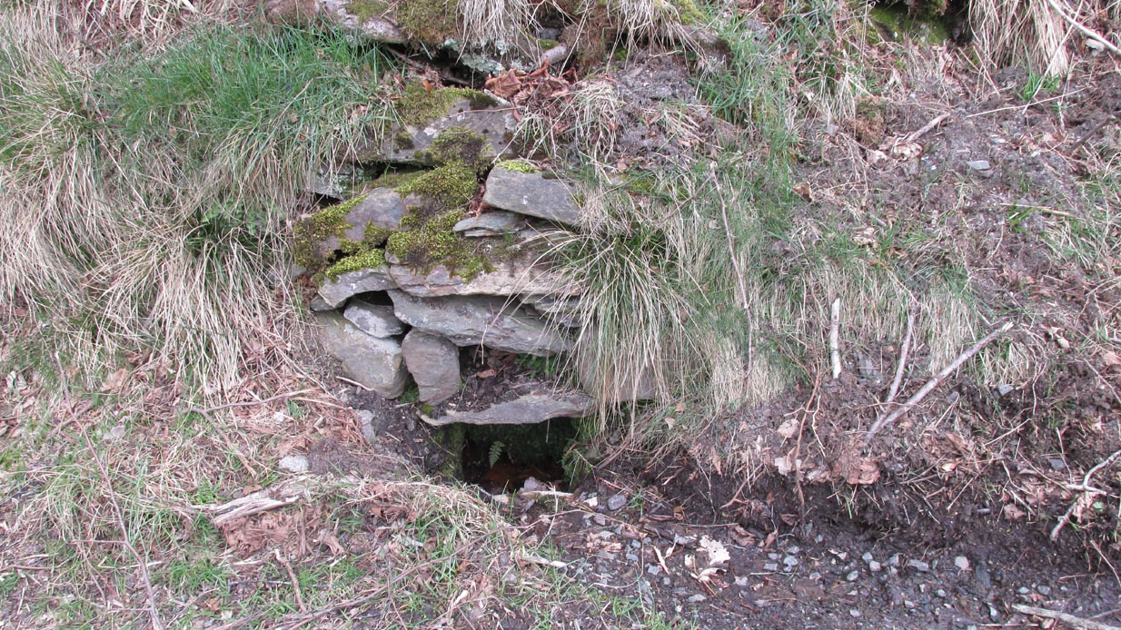
From Fortingall village, head west and turn down into the incredible beauty that is Glen Lyon. As you enter the trees, a half-mile along you pass the small gorge of MacGregor’s Leap in the river below. 2-300 yards pass this, keep your eyes peeled for an old small overgrown walled structure on the left-hand side of the road, barely above the road itself. A large tree grows up above the tiny walled enclosure, within which are the unclear waters that trickle gently….
Archaeology & History
In previous centuries, this all-but-forgotten spring of water wasn’t just a medicinal spring, but was one of the countless sites where sympathetic magick was practised. The old Highlanders would have had a name for the spirit residing at these waters, but it seems to have been lost. The site is described in Alexander Stewart’s (1928) magnum opus on this stunning glen, where he wrote:
“Still a few yards more and Glenlyon’s famous mineral wishing well is seen gushing up, surrounded by its wall of rough stones now sadly in need of repair. It has a stone shelf to receive the offerings of those who still retain a trace of superstition or like to uphold old customs as they partake of its waters. The offerings usually consist of small pebbles, but occasionally something more valuable is found among them. The roadmen may clear that shelf as often as they like, but it is seldom empty for long.”
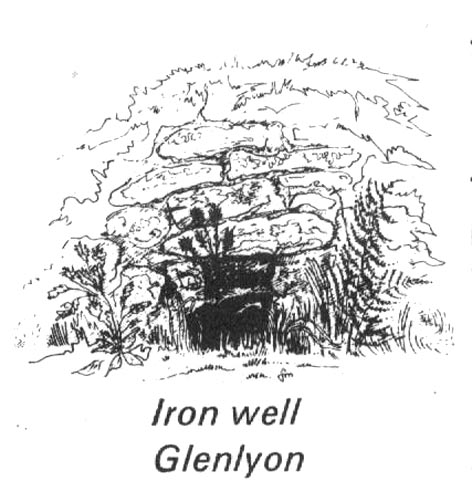
A local lady from Killin told us that she remembers the stone above the well still having offerings left on it 20-30 years ago. Hilary Wheater (1981) sketched it and called it the Iron Well.
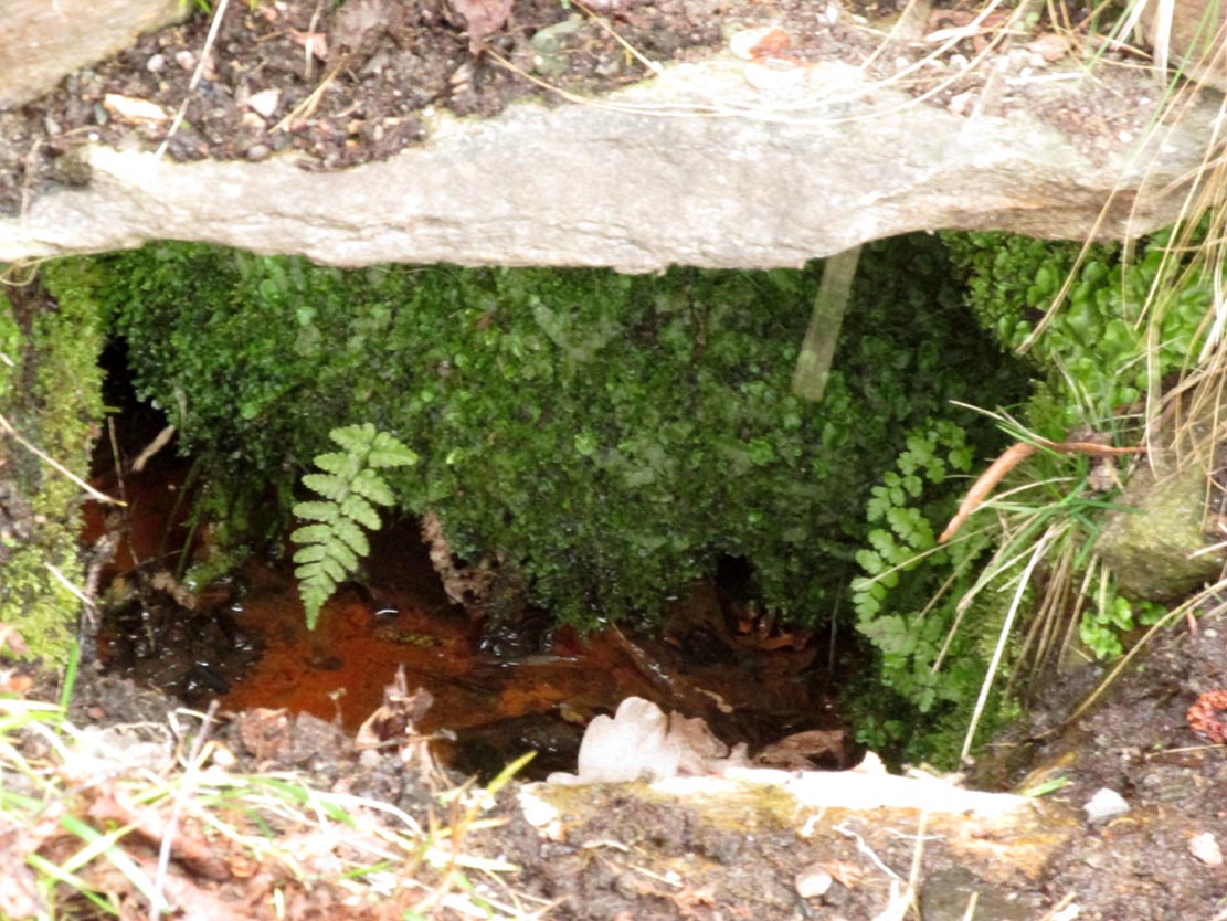
Close-up of the waters (photo by Paul Hornby)Hilary Wheater’s sketch
The waters in this small roadside well-house actually emerge some 50 yards up the steep hillside (recently deforested) and in parts have that distinct oily surface that typifies chalybeates, or iron-bearing springs – which this site is an example of. Its medicinal properties would help to people with anaemia; to heal women just after childbirth; to aid those who’d been injured and lost blood; as well as to fortify the blood and stimulate the system.
Across the road from the well, Stewart (1928) told of a giant lime tree that was long known to be the meeting place for lovers (perhaps relating to the well?), and the name of the River Lyon here is the Poll-a-Chlaidheamh, or ‘the pool of the sword’, whose history and folklore fell prey to the ethnic cleansing of the english.
References:
Stewart, Alexander, A Highland Parish, Alexander Maclaren: Glasgow 1928.
Wheater, Hilary, Aberfeldy to Glenlyon, Appin Publications: Aberfeldy 1981.
In a discussion about the ancient chapel to St. Eonan (the local name in these parts for Adamnan) that once existed near the Bridge of Balgie in Glen Lyon, the local historian Duncan Campbell (1886) informed us that,
“St. Eonan built his chapel near the only stone circle in Glenlyon. The stones of this circle have been removed within my memory. The place is called Clachaig.”
The same writer (Campbell 1888) later told how its remains were still visible around 1848 CE. Campbell’s (1910) later memoirs also mentioned his childhood recollections when the stone circle was in situ, telling that the
“place above the churchyard to Clachaig, named so, the Place of Stones, (was) because the old Druidic stone circle was there.”
We don’t know exactly where the megalithic ring stood; and although modern analysts think the site may have been underneath the invading forestry commission plantation, local lore puts it closer to the graveyard above Kerrowmore.
Enhanced image of curious near-circular form close by
A local dowser thinks that the upright slab in the graveyard at Kerrowmore may be the one remaining stone left here after the circle’s destruction. A quick meander back and forth on a rainy day here, on the geological ridge at the back (south) of Kerrowmore, found only a curious near-circular earthwork that might have been the original site, but it may be fortuitous. A nearby rock outcrop known as “Coill a’ Bhaird” may have been related to the circle.
Folklore
A local man (thanks Tom) said how tradition tells that some of the stones from this circle were taken and used in making the drive to Meggernie Castle last century.
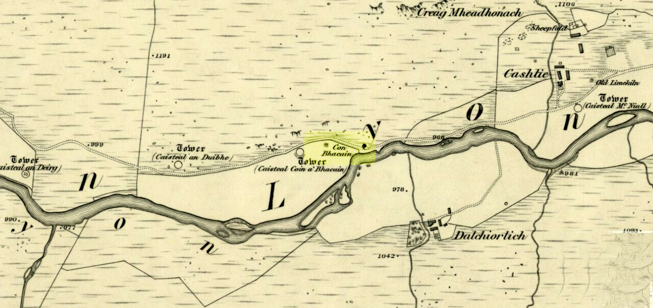
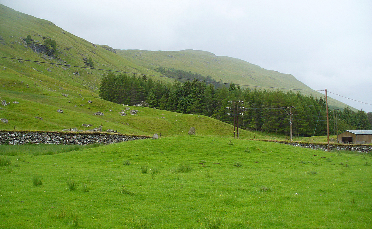
Whether you take the road west from Fortingall, or over the heights from Loch Tay, when you reach Meggernie Castle just keep going west for a few more miles. Keep going past the large Stronuich reservoir on your left and you’re getting close. Go past Caisteal Mhic Neill and the trees at Cashlie House for another 5-600 yards and where the track crosses the river Lyon, park up just past it. Ahead of you in the field on the left of the road, nearer the riverside, is where you need to look.
Archaeology & History
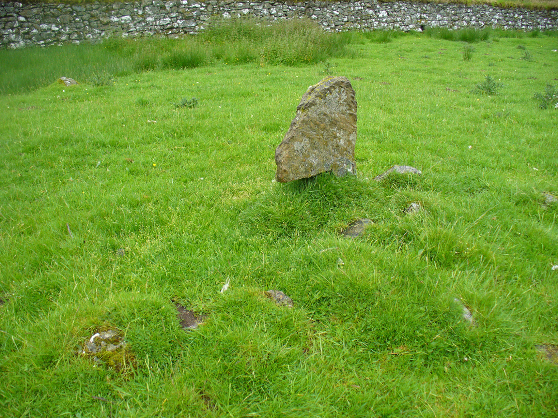
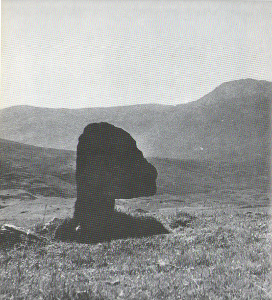
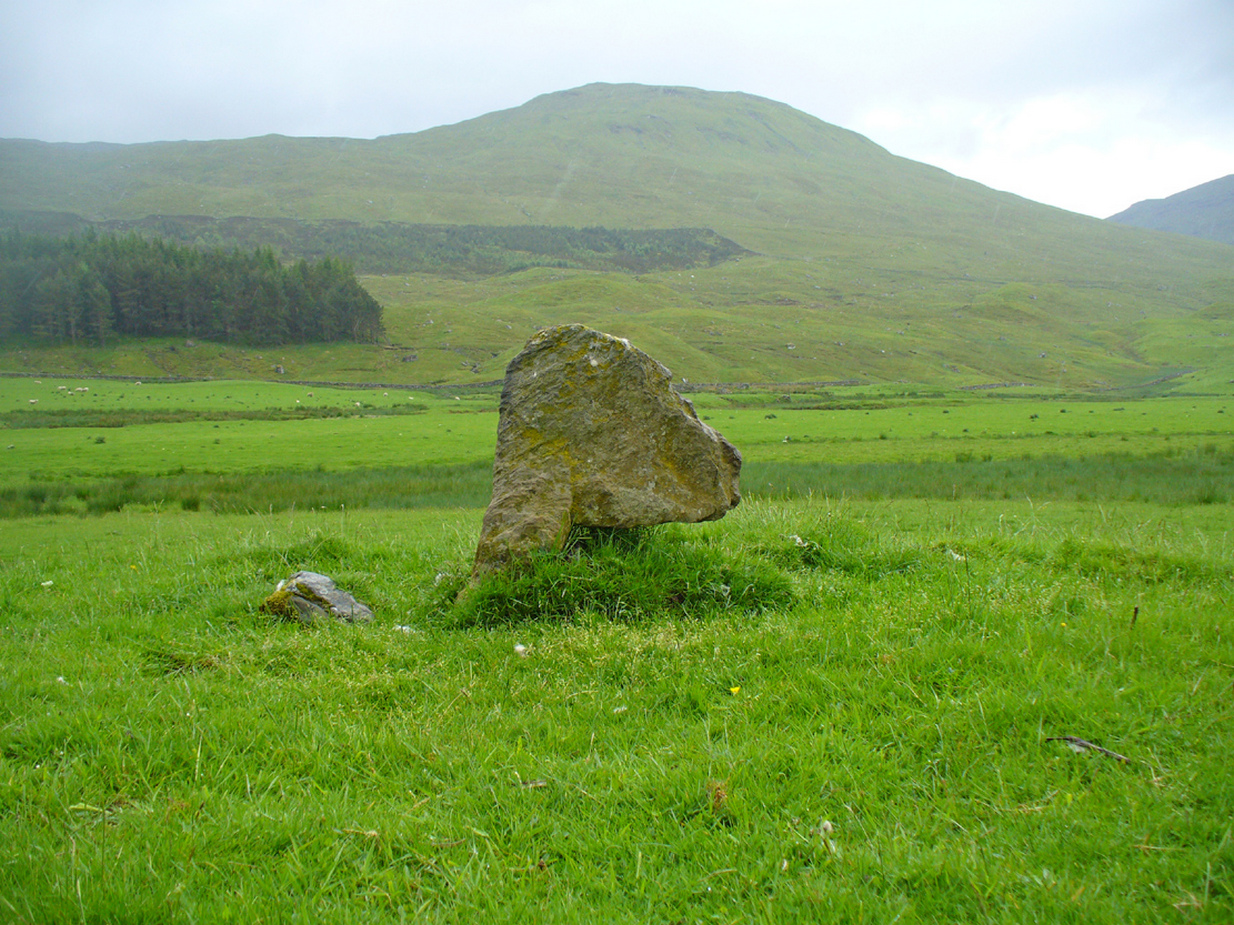
One of the most peculiar and unique sites in the British Isles is this remote small upright stone, known locally as The Bhacain. Standing upon a small mound in the field immediately east of one of Finn’s legendary ‘forts’ (a dun or a broch) called Caisteal Cona Bhacain, this curious monolith, less than two feet tall, has a thin upright stem with a much enlarged rounded end to it. Some might even ascribe it as phallic—although local traditions of the stone relate it as a truth-sayer of a young girl’s virginity!
The Bhacain on 1867 mapMound of The Bhacain
Its position on top of the small mound is intriguing, giving it the impression of being atop of a tumulus; and there is also the scatter of small stones surrounding the upright just beneath the surface (as evidenced in one of the photos), making it possible that the stone is an ancient burial marker. If this is ever shown to be true, the likelihood is that the stone marks the grave of a hound, as the tradition of this spot implies. No excavation has ever occurred here, so the precise nature of the stone (and the mound) has yet to be ascertained; but knowing the longevity of some oral traditions in these Highland glens, the idea of it being the burial-place of a dog is anything but far-fetched.
If the stone is contemporaneous with the associated ‘duns’ close by, this would be a late standing stone, probably erected in the Iron Age. We can certainly see, quite plainly from the erosion on the stone, that this is not neolithic or Bronze Age in origin. A decent examination of the important sites hereby is long overdue…
Folklore
The Bhacain & its stony pile
The folklore and traditions attached to this site are numerous when you consider how small it is. Much of this relates to the fact that animistic cosmologies in the Highlands were retained until very recently, stretching way back. Accounts from the 19th and 20th centuries tell of people still frequenting this and other sites, at sunrise, or full moons, as such things were still very much integral parts of rural life. When the local historian Duncan Fraser (1973) wrote about The Bhacain in his fine work on this area, he told much about the traditions of the great warrior King Fionn and his activities hereby:
Duncan Fraser’s old photoThe Bhacain, looking S
“Another traditional link with the warrior King is the Bhacain, on a mound beside the road, far up the glen. Only a stone’s throw from one of the forts, it is about two feet high and shaped like the head of a dog. This is said to have been the stake to which the Fians tethered their staghounds with leather thongs, when they returned from the chase. And there were times, no doubt, when Fionn’s own dog, Bran was among them, with its yellow paws and its black flanks and its chain of pure gold. It was the best hunting dog that ever lived. And there was its brother, the dreaded Grey Hound, that used to roam on its own in the Great Glen, tearing its victims limb from limb, until it too abandoned its wildness and became one of the hounds of the Fians. They say that the dogs’ food was thrown to them from the top of Caisteal Coin-a-bhacain, the castle of the dog’s stake, upwards of seventy yards to the west. And any dog that failed to catch its supper was turned out of the pack.
“Time did not allow the Bhacain to become inanimate like other stones. Even in comparatively recent times it was still regarded with superstitious awe. A retired schoolmaster of Fortingall recorded eighty years ago that it was said to have a mysterious effect on those who crept under its head. And old folk in the glen will tell you that those who did so were girls. It had become the glen folk’s yardstick of virginity. In the late eighteenth century, when the girls returned from gathering the harvest in the ungodly Lowlands, under the stone they went. It was better than all your modern pills.”
In Hilary Wheater’s (1981) fine work on the history of the region, he told that “no youth was permitted into the fighting body of the Clan until he could lift the Bodach Stone onto the boulder beside it.” This tradition gave the Bhacain another name, the Testing Stone of the Fianna.
References:
Burke, Peter, Popular Culture in Early Modern Europe, Scolar Press: Aldershot 1994.
Fraser, Duncan, Highland Perthshire, Standard Press: Montrose 1973.
McKerracher, Archie, Perthshire in History and Legend, John Donald: Edinburgh 1988.
Stewart, Alexander, A Highland Parish; or, The History of Fortingall, Alex MacLaren: Glasgow 1928.
Wheater, Hilary, Aberfeldy to Glenlyon, Appin Publications: Aberfeldy 1981.
Get to Pubil at the top of Glen Lyon, then walk on the track on the north side of Loch Lyon. Several miles along you turn up Glen Meurain. When you reach the crossing of the stream, follow the waters up Allt Meurain for about 3-400 yards until you find a small flat section of marshland right by the streamside. You’ll notice rocky undulations of human remains here, and a distinct small cairn of rocks near the top of this section. Have a good rest here (and I’d advise avoiding the place in the summer months).
Archaeology & History
Remote indeed is this small cairn—less than 3 feet high and 4 feet across—sitting by the burn-side in a place many miles from any human habitation. It is found amidst a small cluster of other archaeological remains close to each other, as if indicating a settlement of sorts, abandoned probably around the time of the Highland Clearances. Although it is highlighted on modern OS-maps in antiquated lettering, the cairn here looks like it is only a few centuries old. A larger mass of rubble stone is found adjacent to the small pile of rocks, from which it may originally have been taken. Without archaeological analysis we will not know for certain the real age of this old tomb.
MacRee’s Cairn & adjacent rubble
Folklore
The small grassy hillside immediately across the trout stream here is known as Sith Trom’aidh – the Sad Fairy mound, whose history appears to have been lost. Alexander Stewart (1928) told that this cairn was the burial place of one of Colin Campbell’s dairymaids, found and slain here during a skirmish with cattle raiders in the 16th century.
References:
Stewart, Alexander, A Highland Parish; or, The History of Fortingall, Alex MacLaren & Sons: Glasgow 1928.
From Fortingall, get to the standing stone of Adamnan’s Cross a few miles down the stunning Glen Lyon. Barely 100 yards before you reach the stone, notice the overgrown gorse-covered rocky rise across the road, just past Craigianie Farm. As you climb to the top of this small rocky rise, you’ll see a cairn of stones on its top. Just below it, into the solid rock, you’ll see a footprint-shaped hollow etched into the stone. If it seems hidden, just keep looking – you’ll find it…
Archaeology & History
St. Palladius Stone, Glen Lyon
When Ratcliffe Barnatt (1944) visited Glen Lyon in the 1940s, this legendary rock was one of his stopping points. “When we have passed by Ruskich and Slatich,” he wrote, “we come to that sacred spot, Craig Dianaidh, the Rock of Safety, where, until about 1480, solemn and judicial meetings were held.” The old rock was known through recent ages, “as a preaching hill, a motehill and a justiciary court,” said Hilary Wheater (1981), and upon its top is the curious ‘footprint’ which Nature’s blood would fill on all but the hottest of summers. It is this geological feature that gave the stone is name, long ago.
Of known historical events here, Wheater further told:
“It was on this rock…that the Baron Courts of Glenlyon were held. Law and order was kept by regular courts held by the Chief or Landowner. The Baron-Bailiary of each area was appointed by Royal Charter. Fifteen men were chosen as a jury and the laird or his baile presided. To this court were brought all the problems and grievances of the people. Here the miller accused several men of refusing to take part in the compulsory ‘hamganging’ of a new millstone; here a man was fined for brewing ale without a license; here a neighbour was accused of putting the ‘evil eye’ on the cow of the croft next door so it produced no milk; and here a man was prosecuted for ‘taking of ane sore horse of his to Rannoch in the summer of 1629 and putting on him ane great burder of timber, and letting him go through the wood where he stuck between two trees all night and the timber on his back.’ However, he was acquitted when he was able to prove that the horse was fit enough after this for another man to be able to take it to Edinburgh soon after.”
St Palladius Footprint
As well as being a moot site, it is more than probable that this footprint, like the one near the top of Dunadd in Argyll—and others scattering the Highlands and beyond—was an initiation stone, perhaps for local tribal elders or ancient kings. Janet Bord (2004) writes about them as places of ritual inauguration in her survey of such places.
Folklore
The legendary site, looking south
This legendary rock would probably have had earlier mythic association than the one ascribing it to St. Palladius—but as yet I have found no written lore telling the nature of such a spirit, so would only perhaps discern the original genius loci by lengthy encounters with the rock in question, through mist and storm and wintry months, alone. It is known in local folklore that Palladius was in fact an urisk: a solitary spirit of steep streams that few humans encounter due to their lonely habits amidst hidden abodes in dark and ancient gorges. Such urisks dwelt in numbers amongst many of the steep falls in this landscape — and still do, if the words of old locals are to be believed. Here,
“St Palladius was a goblin saint, an urisk that dwelt in a mountain burn and was sanctified by the people.”
…and some rocks by the stream up the mountain immediately above this “footprint” was one of the places the urisk was known to dwell.
…to be continued…
References:
Barnatt, T. Ratcliffe, The Road to Rannoch and the Summer Isles, John Grant: Edinburgh 1944.
Bord, Janet, Footprints in Stone, Heart of Albion Press 2004.
Fraser, Duncan, Highland Perthshire, Standard Press: Montrose 1969.
Wheater, Hilary, Aberfeldy to Glenlyon, Appin Publications: Aberfeldy 1981.
Dun (lost): OS Grid Reference – NN 539 386 (approximation)
Looking towards Laraig Bhreislich, from the south
Also Known as:
Dun croisgh
Lairig Breisleich
Laraig Bhreislich
Archaeology & History
Although this site doesn’t appear in the modern records, the remote situation of the place suggests that some remains of the site could remain and be uncovered by diligent explorers and students. It is one of several lost “circular forts” that were described in William Gillies’ (1938) detailed historical text, that were first highlighted on a map of 1769. His brief description of this old fort told,
“The name ‘Duncroisg’ in Glenlochay, bears witness to the fort that once stood at the southern entrance to Laraig Bhreislich, the pass leading over the mountain to Glenlyon.”
There is is the possibility that some of the remote shielings clustered on the level at Airigh Allt an Eilein and Riabhaich used stones from this ancient site for their construction. On the level to the south of here are the overgrown remains of a prehistoric cairn, not included in archaeological surveys.
Note – Huge sections of prehistoric man-made walling have been located in the area, comprised of gigantic boulders, more reminiscent of enclosure walling. The remains are extensive and huge, but severely overgrown in this remote landscape. Watch This Space!
Folklore
Although not named specifically, this site would have been another of the Forts of the Fiann, or tribes of the hero-figure, Finn. The valley immediately adjacent to the location of the fort is still known as Fionn Ghleann, with the waters of Allt Fionn Ghleann strongly flowing through.
References:
Gillies, William A., In Famed Breadalbane, Munro Press: Perth 1938.
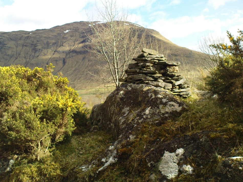
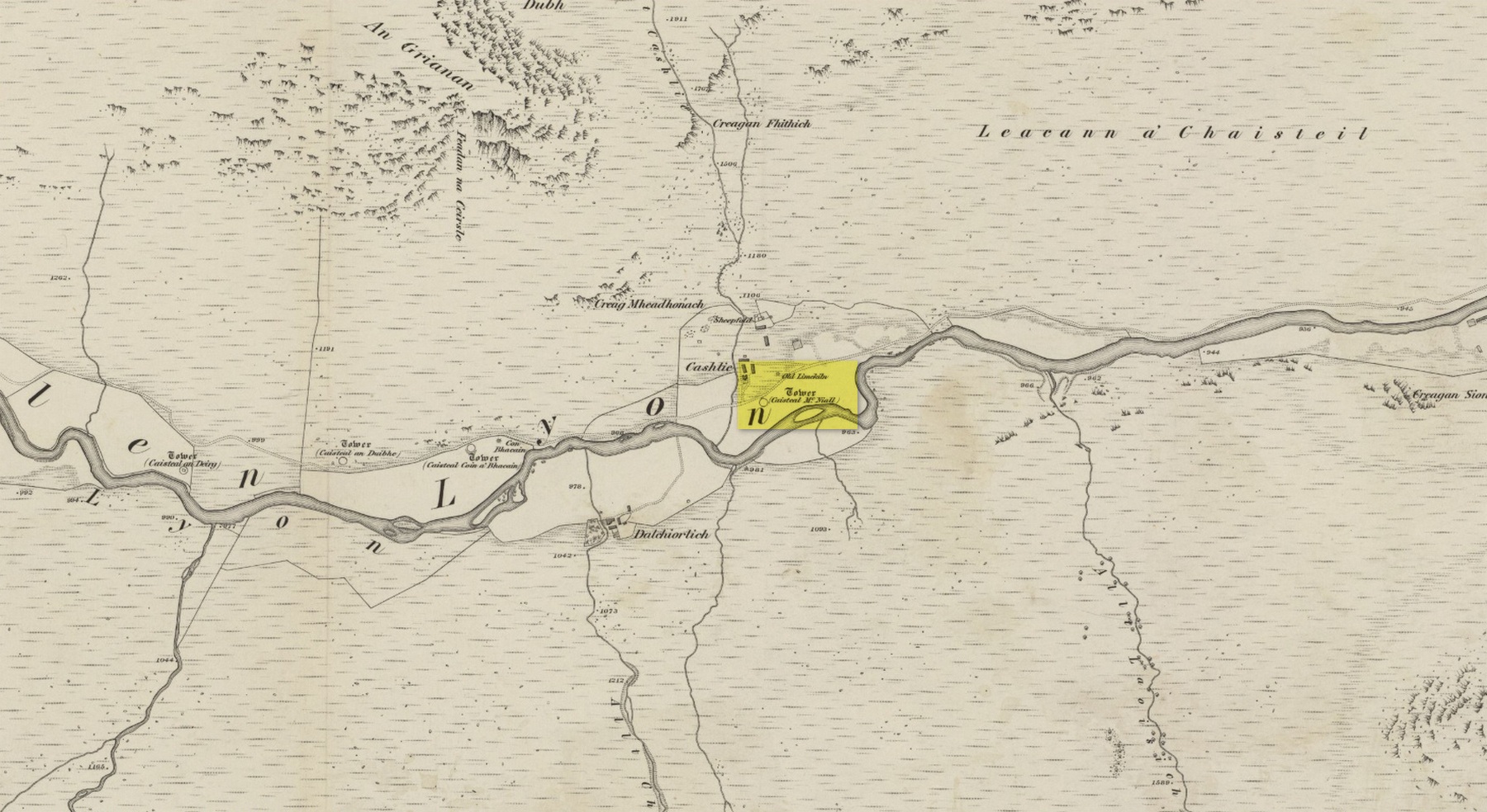
Truly remote, but easy to find once you’re nearing the western end of Glen Lyon. Going upstream, past Cashlie Dam, watch out for the well-preserved stone kiln on the left-hand side of the road, just before Cashlie house. 50 yards or further along, cross the road and in the field by the riverside, the circular mass of stones sorta gives the game away.
Archaeology & History
Shown on modern OS-maps as a ‘homestead’ and described variously by archaeologists and historians as a fort or a round-house, this is just one example of around twenty large prehistoric constructions that scatter the stunning mountainous Glen Lyon region which legend tells were the forts of the great hero-figure, Finn. Three other constructions of the same nature are found just a few hundred yards further up the Glen from here. Each is of roughly the same age and nature by the look of things. Their walls are extremely wide and made up of very large rocks, which would have taken huge efforts to construct.
Caisteal Mhic Neill ruins, looking eastCaisteal Mhic Neill, with An Grianan behind
Highlighted on the 1867 OS-map as a “Tower”, the exact nature of this and its adjacent sites has yet to be academically ascertained, with the Canmore website ascribing the monument as a “settlement” – although, tradition tells them to be Scottish forts or duns, so we’ll stick with that until excavations tell otherwise!
The great Gaelic place-name master W.J. Watson (1912) told that:
“The fourth of the Cashlie towers is a few yards south of the road, right in front of Cashlie farmhouse, now a shooting lodge. Though a quantity of large stones marks the site, the structure has been so badly knocked about that we found it impossible to take measurements sufficient for a plan. It was, however, apparently not circular, but rather oval. Its walls appeared to vary from about 9 feet to 12 feet 6 inches in thickness.”
Close-up of Caisteal walling
This is one of several other duns (or homesteads as the OS-map calls them) close to each other.
Folklore
Ascribed as one of Glen Lyon’s Caisteilean nam Fiann, or “castles of the Fiann”, Mr Watson (1912) again told how “there is a widely known saying, the earliest notice of which occurs in Pennant, who got it doubtless from the Rev. J. Stewart:
‘…Twelve castles had Fionn,
In the dark Bent-glen of the stones.'”
References:
Gillies, William A., In Famed Breadalbane, Munro Press: Perth 1938.
Watson, W.J., “The Circular Forts of North Perthshire,” in Proceedings of the Society of Antiquaries, Scotland, volume 47, 1912.
ACKNOWLEDGEMENTS: Many thanks to Andy Sweet of Stravaiging Around Scotland, for pointing me to the W.J. Watson article. And of course, a huge thanks to Marion—”I don’t have a clue where I am!”—Woolley, for getting us here….
Take the road from Fortingall into the Glen. About 4 miles down, past the farmhouse of Slatich, then Craigianie, watch carefully as you round the small bend in the road, where you’ll see a small standing stone on top of a rounded mound, right by the south side of the road, just over the fence. Go through the gate to enter the field less than 100 yards further on and walk back onto the hillock.
Archaeology & History
In this magnificent landscape down the longest of Scotland’s glens, standing atop of a knoll known as Tom a’ Mhoid, or “the moot hill” (Watson 1926), is this small standing stone about 4 feet tall which has long been ascribed as an important relic of the early christian period. They may be right – but it could as much be a more archaic monolith, onto which the carved crosses on either side of the stone were later etched, in the light of the myths of St. Adamnan whose name scatters this great glen and after the legend cited below was ascribed to him.
Close-up, showing large cross
The stone ‘cross’ stands atop of what at first sight seems a natural knoll; but all round it we find an excess of man-made remains and walling, all but constituting the hill itself. These are clearly visible on the aerial imagery of GoogleEarth. Antiquarian dogs here would be invaluable to ascertain the correct age and nature of the structures around this ‘cross’.
Faint cross near top of stone
Of the crosses carved onto the stone: the one on the southern face is a small faint one near the top of the upright; whilst the other is much larger and is easily visible, cutting right across the northern face of the monolith. They are clearly of differing styles and would seem to have been carved by different people, perhaps a few centuries apart. Curiously—as Marion Woolley pointed out—the smaller, fainter cross is carved above a ridge on the upright stone, mimicking the position of the stone on the knoll in its landscape setting. Whether this is just a coincidence, or has been done on purpose, we might never know.
In Duncan Fraser’s (1969) excellent local history work, he names the stone here Eonan’s Cross and he too strongly suspects “the stone itself was probably erected at least a thousand years earlier” than the coming of the saint, making this a christianized standing stone – which it certainly looks like. Mr Fraser said that,
“His cross stone, we can be fairly sure, was a Bronze Age standing stone long before it acquired its unusual cross.”
He may well be right…
Folklore
The mythic history of this cross-marked standing stone was told eloquently in one of Hilary Wheater’s (1981) fine short works. After giving a brief story of the tale of St. Adamnan, she went on to tell:
“A terrible plague swept through Scotland in the seventh century. It reached the Vale of Fortingall and so violent was its ravages that all the inhabitants were wiped out. Slowly the sickness began to infiltrate the Glen and in a panic the people of Glenlyon went to their preacher and beseeched him, “Eonan of the ruddy cheeks, rise and check the plague of thy people. Save us from the death and let it not come upon us east or west.”
“Adamnan rose to the occasion and gathered the people of the Glen to a hillock where he usually preached to them. In a house not forty yards away it is said that a child was already dying of ‘the Death.’
“There on the rock, with the people gathered round him, Adamnan prayed. When he was finished he raised his right arm, exhorted the devil body of the pestilence to come to him and, pointing to a large round rock lying on the ground, ordered the plague to enter it. A large circular hole appeared in the rock as the plague bored into it and Adamnan followed up this apparent miracle by the very sensible act of sending all the healthy people of the Glen up to the shielings until all signs of the pestilence disappeared…
“Thus were the people of the Glen saved from the plague. When they came back from their mountain retreat they erected a stone slab with two crosses on it to commemorate their deliverance. The rock itself they called Craig-diannaidh, the ‘rock of safety’, and the round stone with the hole through which the plague descended into the bowels of the Earth lies to this day at the side of the road near the stone slab.”
Adamnan’s Cross
The rocky slope immediately above the stone, on the other side of the road, was once the home of an old urisk who, sadly, long-since left the area – though his spirit can still be felt there. Accounts of many other supernatural creatures are found scattering this part of Glen Lyon…
References:
Barnett, T. Ratcliffe, The Road to Rannoch and the Summer Isles, Robert Grant: Edinburgh 1924.
Fraser, Duncan, Highland Perthshire, Standard Press: Montrose 1969.
Watson, W.J., The history of the Celtic Place-Names of Scotland, Edinburgh 1926.
Wheater, Hilary, Aberfeldy to Glenlyon, Appin: Aberfeldy 1981.
ACKNOWLEDGEMENTS: Massive thanks to Marion—”I don’t have a clue where I am!”—Woolley, for getting us here….and for her photo of the faint cross, above.