The best/easiest way to approach this and the Rivock carvings as a whole is to reach the Silsden Road that curves round the southern edge of Rombalds Moor (whether it’s via East Morton, Riddlesden, Keighley or Silsden) and keep your eyes peeled for the singular large windmill. About 200 yards east of this is a small parking spot, big enough for a half-dozen vehicles. From here walk 450 yards east along the road till you hit the dirt-track/footpath up towards the moor. Follow the track up for about 400 yards and you’ll see the crags a half-mile ahead of you. Get up there to the Wondjina Stone and follow the walling east for about 175 yards where you’ll see a track-cum-clearing in the woods. Walk along and the first large stone on your left is what you’re after.
Archaeology & History
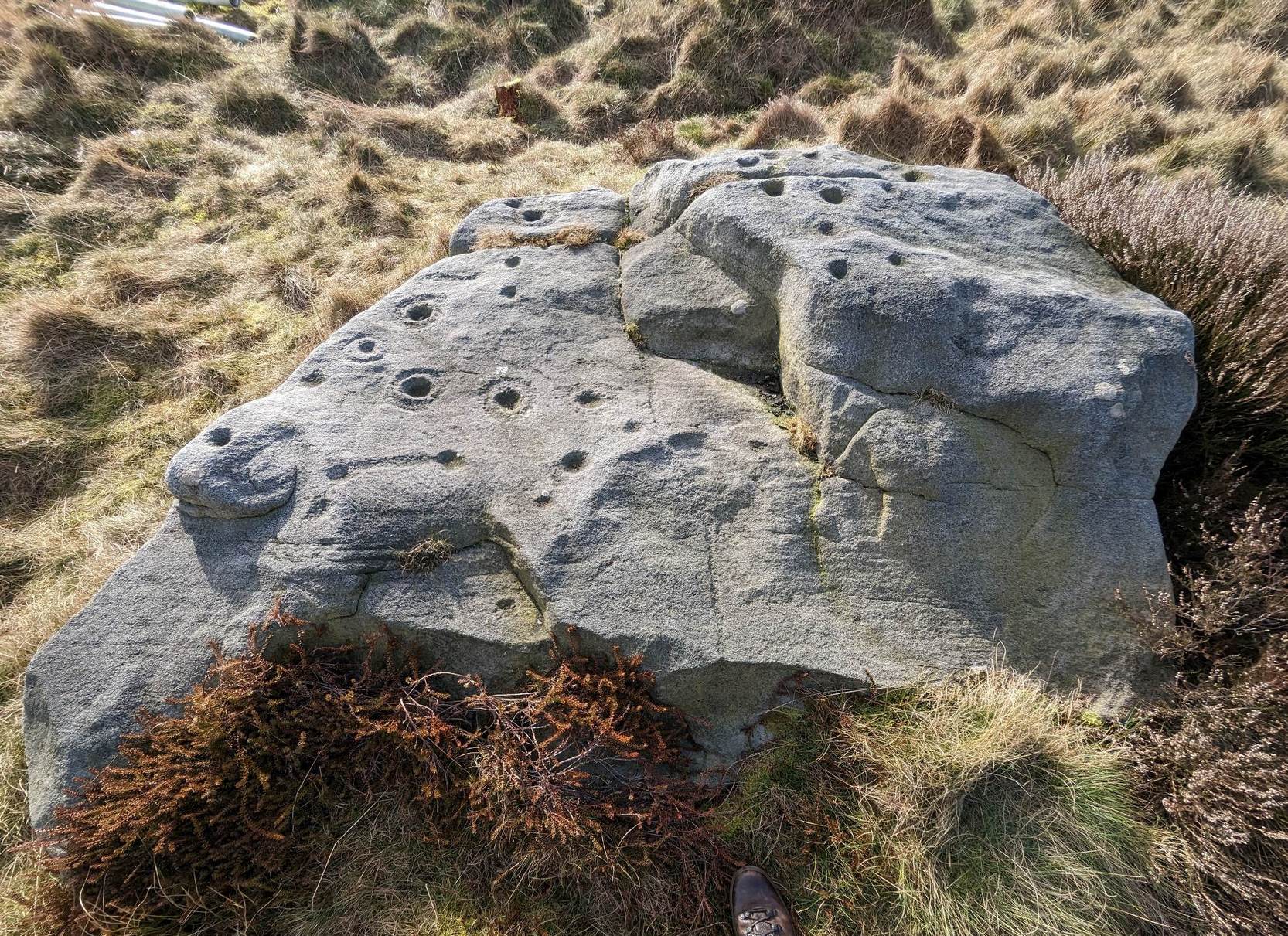
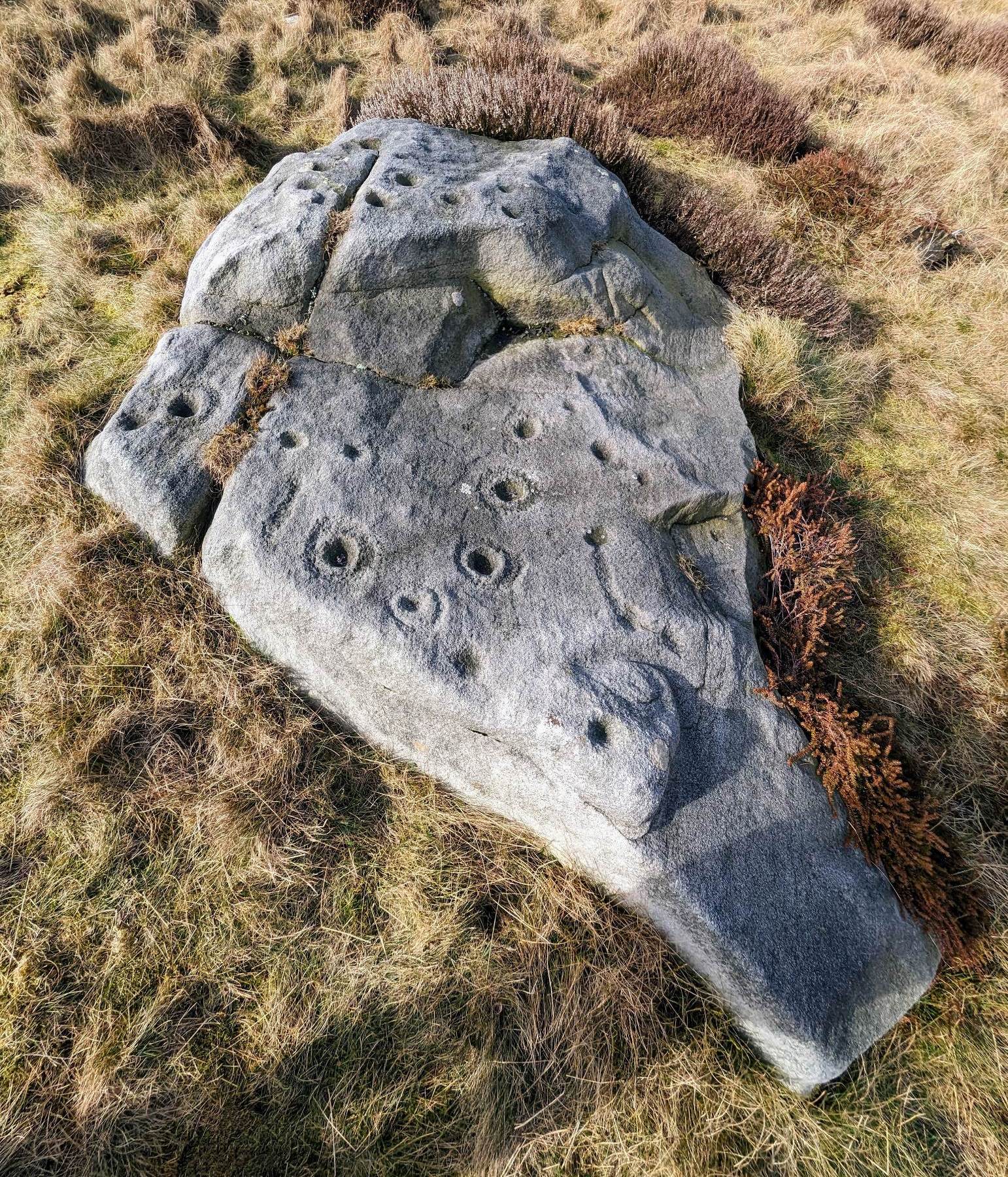
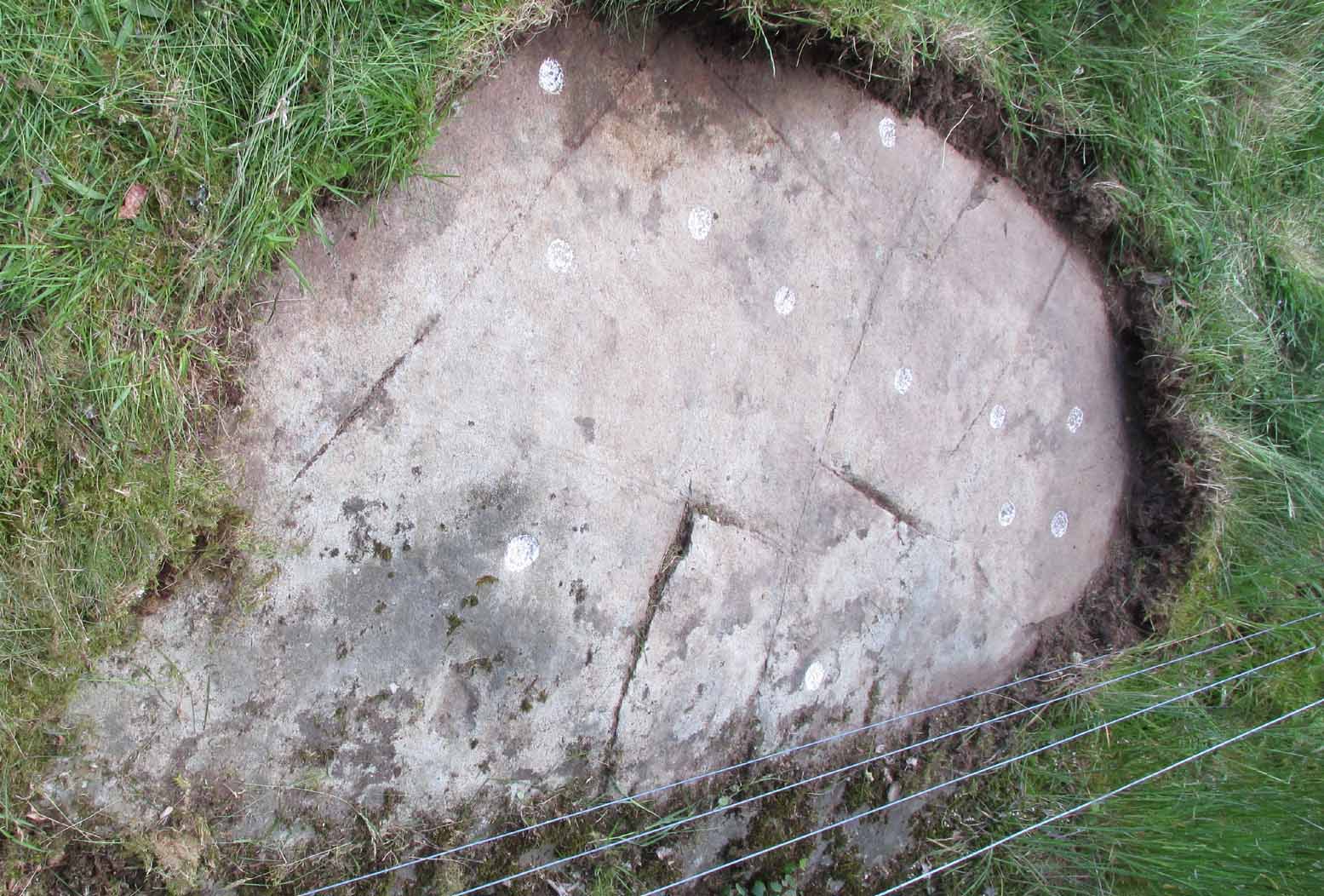
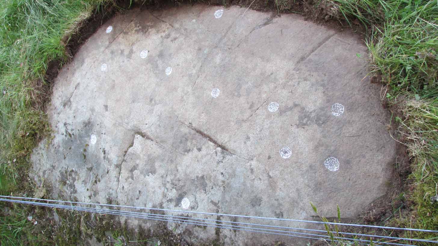
I first visited this carving in my teenage years in the 1970s, before the intrusive so-called “private” forest covered this landscape and when its petroglyphic compatriots were easier to find. Thankfully this one’s still pretty accessible and possesses a damn good clear design. It was rediscovered in the 1960s by Stuart Feather and his gang, zigzagging their way across the open moors, pulling back the heather to see what they might find. His description of it told how the stone,
“has two roughly level areas, one 18ins and the other 2 feet above ground level. Both (levels) have several well-preserved cup-and-ring markings on them. There are eight single cup-and-rings and 18 cups, two of the latter being joined by a clear channel seven inches long and 1½ inches wide. Nearly all the markings are unusually well preserved and the pocking marks are very clear.”
Note the line running down
He also had “the impression that all the markings on this stone and possibly one other similar stone in the Rivock area have been carved by the same hand, as all the symbols are nearly identical in in type, size and execution.” (this other carving he’s referring to seems to be one about 170 yards to the north, where occasionally “offerings” have been found)
The design from E-W
When John Hedges (1986) and his team checked the stone out he could only make out “seven cups with single rings, twenty two other cups”; whilst the ever descriptive Boughey & Vickerman (2003) saw “twenty-nine cups, eight with single rings.” Eight cup-and-rings is what most people see when the light’s right. There’s also a long, bent carved line on the lower level of the rock, running from near the middle of the stone out to the very edge. It seems to be man-made (although I may be wrong) – and I draw attention to it as this same feature exists on at least three of the other large and very ornamental cup-and-rings hereby within 300 yards of each other – and on these other carvings the long “line” is definitely artificial. Tis an intriguing characteristic…
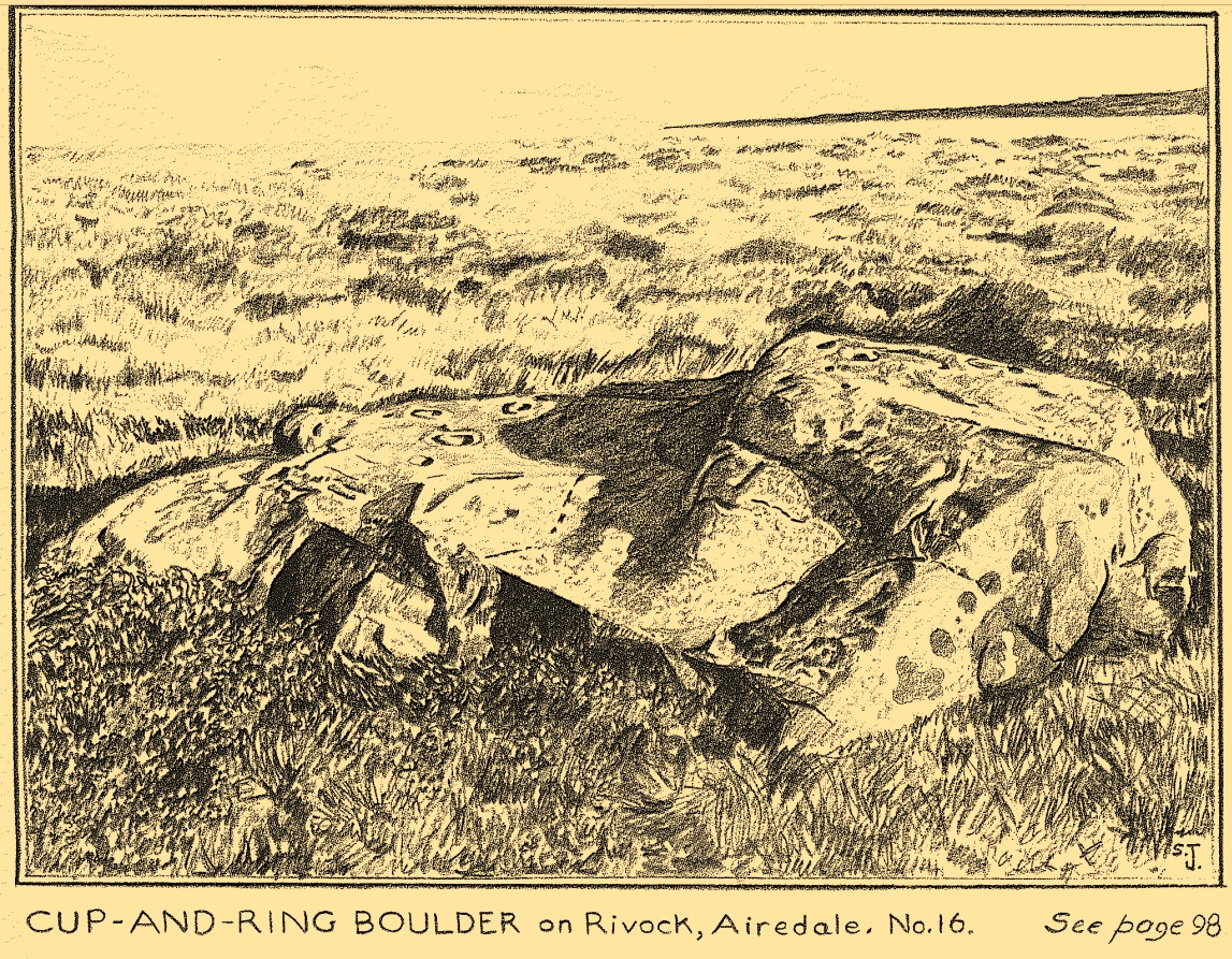
Stuart Feather’s old sketch
When visiting this petroglyph you’ll notice how some of the carved elements on top of the stone are more eroded than those on the lower section. This is due to the fact that the lower section was only revealed by Feather and his team in the mid-20th century, after it had been covered in soil for countless centuries. As a result you can still see the peck-marks left by the implements that were used to make the carving, perhaps 5000 years ago!
The name of the stone was inspired by a local lady who saw an astronomical function in the design (I quite like it as well). Examples of petroglyphs representing myths of heavenly bodies have been described first-hand in some tribal cultures and, nowadays, even a number of archaeologists are making allusions about potential celestial features in some carvings in the British Isles. That doesn’t mean to say that it’s correct, but the idea’s far from unreasonable…
Anyhow – check this one out when you’re next up here. You’ll like it!
References:
Bennett, Paul, “The Prehistoric Rock Art and Megalithic Remains of Rivock & District (parts 1 & 2),” in Earth, 3-4, 1986.
Boughey, Keith & Vickerman, E.A., Prehistoric Rock Art of the West Riding, WYAS 2003.
Deacon, Vivien, The Rock Art Landscapes of Rombalds Moor, West Yorkshire, ArchaeoPress: Oxford 2020.
Feather, Stuart, “Mid-Wharfedale Cup-and-Ring Markings – no.16 – Rivock,” in Cartwright Hall Archaeology Group Bulletin, volume 8, no.10, 1963.
Hedges, John (ed.), The Carved Rocks on Rombalds Moor, WYMCC: Wakefield 1986.
Morris, Ronald W.B., “The Prehistoric Rock Art of Great Britain: A Survey of All Sites Bearing Motifs more Complex than Simple Cup-marks,” in Proceedings of the Prehistoric Society, volume 55, 1989.
Acknowledgments: Huge thanks to Collette Walsh for use of her photos.
Out of Aberfeldy, take the A826 road as if you’re going up Glen Cochill. Not far up, just where the housing of Aberfeldy itself ends and the green fields open up either side of you, keep on the road for a half-mile where you meet a small copse of trees on your left, with a dirt-track that runs down the slope. Go down the track, bending to the right, then the left and then on for a quarter of a mile until the lines of trees appear either side of you. Barely 200 yards along, the track swerves slowly to your right, and the field above you slopes uphill. Keep your eyes peeled at the fencing on your right and you’ll see a stone sloping towards you right by the fence with faint cup-marks on it. You’ll find it!
Archaeology & History
A truly fascinating cup-marked stone recently uncovered by Paul Hornby on another one of our TNA meanderings. Fascinating because of the curious arrangement of the cups on the stone. Often, cup-marked stones have little to interest the causal visitor – but this one’s different. As can be seen quite clearly, the cups are arranged in the shape of the constellation of the Great Bear, or Ursa Major – albeit with an extra ‘star’ in this design. But it’s damn close! In all likelihood (he says with his sceptical head on 😉 ), the design is fortuitous when it comes to the Ursa Major. I know from many years experience how easy it is to see meaningful shapes and designs in the almost entirely abstract British petroglyphs, but the design is very close to the constellation we all got to know when we were kids.
Looking along the stoneGazing down at Ursa Major
The stone itself slopes upwards at an angle of about 60º, before starting to level out as it rises. All of the cup-marks have been pecked onto this sloping surface (the vast majority of carvings are found on top of stones). Altogether, at least twelve faint and shallow cups were exposed when we looked at it—measuring the usual inch to inch-and-half across—but it is likely that more of them are hidden beneath the turf at the top of the stone. We could discern no rings or other features in the design.
This is just one carving amidst a good cluster of petroglyphs within a few hundred yards of each other (the Quartz Stone being one of the nearest) that are well worth checking out if you like your rock art. It may also be of interest to astronomy students, or those exploring archaeo-astronomy.
References:
Yellowlees, Sonia, Cupmarked Stones in Strathtay, RCHAMS 2004.
You can either find your way to Duntreath Castle on the western edges of Strathblane and walk SW straight up the steep grassy slope next to the wooded Dumgoyach Hill; or… From Carbeth, north along the A809, turn right up the B821 Ballachalairy Yett road for 1km and park where the path of the West Highland Way runs onto the hills. Follow this path for nearly ½-mile and where the path splits, bear left. Keep walking downhill for a few hundred yards, then go off-track towards the copse of trees. Climb over the gate and onto the grassy plain between this copse and the huge rounded Dumgoyach Hill. The stones are very close indeed…
Archaeology & History
This is a truly stunning site – not as much for the megaliths that are here, but for the setting in which they’re held. “Magnificent” is the word that rolled out of my mouth a number of times; whilst respected activist and ‘Organic Scotland’ creator Nina Harris said, quite accurately, “it’s Caras Galadhon in Lothlorien!” (or words to that effect) – and she hit the nail much better than I did!
Royal Commission 1963 sketch
Dumgoyach Stones (by Nina Harris)
A short line of large standing stones remains here, both upright and leaning, running NE-SW for 7 yards: seemingly a part of some other much larger monument in times long past—although very little else remains. The stones are set upon a rise of land, quite deliberately in front of Dumgoyach Hill (or Lothlorien, as Nina called it) almost as a temple or site of reverence. You’ve gotta see it to appreciate what I’m saying! Like some gigantic tree-covered Silbury Hill, the standing stones on this ridge possess an undoubted geomantic relationship with this rounded pyramid, all but lost in the sleep of local myths and land. A few yards away from the line of stones there is a slight rise in the land, seemingly giving weight to the idea that something else was living here: an architectural feature that Aubrey Burl (1993) thinks might have been “the facade of a chambered tomb” (neolithic in origin) and not merely a megalithic alignment. He may be right…
Close-up of the megaliths
Described briefly in J.G. Smith’s (1886) magnum opus on the Strathblane parish, antiquarian accounts of this impressive site seem curiously rare. One of the earliest recognised accounts was done by the Royal Commission (1963) lads who measured the site up with their usual diligence. Although getting the alignment of the stones wrong, the rest of their survey seems pretty accurate. They told that,
“There are five standing stones (A-E) arranged in a straight line… Three of the stones (A, B and C) are earthfast, while the other two (D and E) are recumbent. Stone A is of irregular shape and leans steeply towards the N. The exposed portion measures 4ft in height, 2ft 6in in breadth and 1ft 2in in thickness. Stone B stands upright, 6ft NE of A. It is a pillar of roughly rectangular section with an irregularly pointed top, and measures 5ft in height by about 2ft 6in in thickness. Stone C, also irregular in shape, 11ft 6in NE of B, is inclined so steeply to the NNE that it is almost recumbent. It measures 4ft 4in in height, 2ft 6in in breadth and 1ft in thickness. The remaining two stones lie on the ground between B and C. Stone D measures 5ft 5in in length, 3ft in breadth and 1ft 6in in thickness while stone E, which rests partly on D, measures 7ft 10in in length, 3ft 9in in breadth and 3ft in thickness.”
Aubrey Burl’s (1993) description of the site—which he called Blanefield—is another good synopsis of what is known historically and astronomically about the site. Assessing them in his detailed work on megalithic alignments, he said that,
“At Blanefield near Strathblane in Stirling a big stone, its longer sides aligned east-west, stands at an angle amongst a southwest-northeast line of four others, fallen, of which one just off the line seems to have been added this century. The setting has been presumed a collapsed four-stone row. Known also as Duntreath and Dumgoyach, the setting is slightly concave.
“‘This ruinous alignment indicates notches to the northeast and these show approximately the midsummer rising sun.’ ‘The standing stone has a flat face exactly aligned on a hill notch to the east,’ quite neatly in line with the equinoctial sunrises. These astronomical analyses would seem to confirm that Blanefield was undoubtedly a row set up by prehistoric observers to record two important solar events.
“Excavation in 1972 discovered signs of burning, flints and charcoal that yielded a C-14 assay of 2860±270 BC (GX-2781), c. 3650 BC, a time in the Middle Neolithic when chambered tombs were still in vogue, but an extremely early date for any stone row. This, coupled with Blanefield’s isolated position for a row in central Scotland, raises doubts about its origins.
“It is a lonely megalithic line, those nearest to it being over forty miles (64km) to the west in Argyll. Straddling a ridge overlooking the Blane Water it is arguable that the stones are relics of the crescent facade of a Clyde chambered long cairn with an entrance facing the southeast….”
Dumgoyach Stones, with Dumgoyne to the North
However, there was once another stone row close by, known as the old Stones of Mugdock. Burl then cites the proximity of four nearby neolithic long cairns not too far away, with the Auchneck tomb just 3½ miles (5.6km) to the west; although it seems that Nina Harris may have discovered another one, much closer still.
Folklore
Local legend reputes that King Arthur was up and about in this part of the world, fighting in a battle nearby. And in J.G. Smith’s (1886) excellent work on the parish of Strathblane, he told that,
“The standing stones to the south-east of Dungoyach probably mark the burial place of Cymric or Pictish warriors who fell in the bloody battle of Mugdock.”
References:
Burl, Aubrey, From Carnac to Callanish, Yale University Press 1993.
Feachem, Richard, Guide to Prehistoric Scotland, Batsford: London 1977.
Heggie, Douglas C., Megalithic Science: Ancient Mathematics and Astronomy in Northwest Europe, Thames & Hudson: London 1981.
MacKie, Euan W., Scotland: An Archaeological Guide, Faber: London 1975.
Ritchie, J.N.G., “Archaeology and Astronomy,” in Heggie, D.C., Archaeoastronomy in the Old World, Cambridge University Press 1982.
Royal Commission on the Ancient & Historical Monuments Scotland, Stirling – volume 1, HMSO: Edinburgh 1963.
Smith, John G., The Parish of Strathblane, James Maclehose: Glasgow 1886.
Thom, Alexander, Megalithic Sites in Britain, Oxford University Press 1967.
Thom, A., Thom, A.S. & Burl, Aubrey, Stone Rows and Standing Stones – volume 1, BAR: Oxford 1990.
Acknowledgements: A huge thanks to Nina Harris, of Organic Scotland, for both taking me to these stones and sharing her photos for this site profile. Cheers Nina!
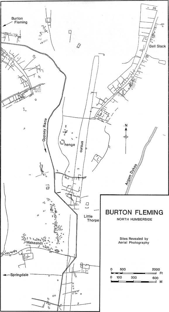
Faint flat outline of SE end + ancient circular enclosure
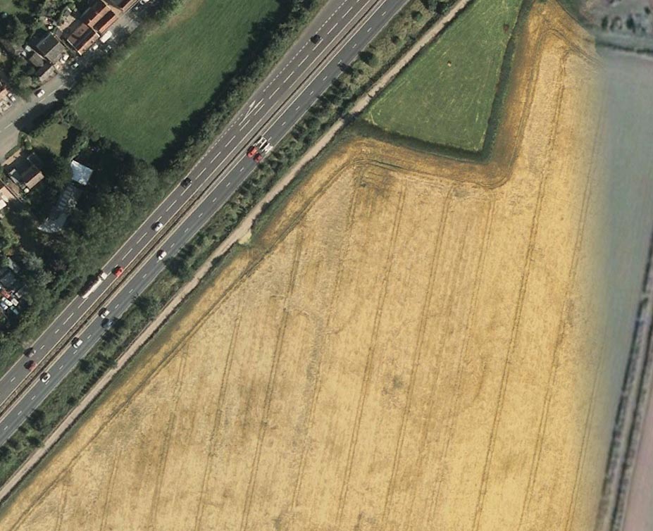
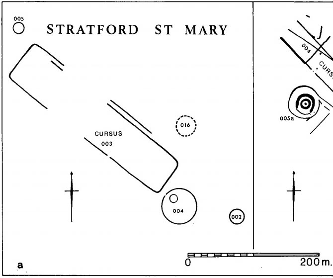
This short and dead straight cursus monument was first described in John Hedges’ (1981) survey, and later mentioned in Harding & Lee’s (1987) corpus on British henges as being in conjunction with a series of circular prehistoric monuments (three circular enclosures existed beyond its southeast and one to its northeast edges, one of which is visible in the aerial image, right).
Cursus ground-plan (courtesy Suffolk Institute Archaeology)
Most of the monument has been completely destroyed by roads and housing, but when complete was said to be 317 yards (290m) long, running from the southeast to the northwest. The flattened southeastern edge measures nearly 63 yards (57.3m) across, and its northernmost width was close to 65 yards (60m) wide.
In Patrick Taylor’s (2015) assessment of this (and other monuments) he thought that the cursus may have served an astronomical function. He may be right. It’s alignment, he told,
“has a very clear orientation 38.5º north of grid west. This represents an amplitude from true west of 40.9º. Allowing for a latitude of 51.97º and altitude of 0.95º, adjusted downwards for refraction to 0.50º, we get from (Alexander) Thom’s table a declination for a body setting to the northwest of 24.15.º This is only 0.23º, just less than half the width of the sun’s disc, more than the sun’s maximum declination in Neolithic times of 23.92º. The alignment thus points rather accurately towards the upper limb or last setting point of the sun.”
Faint remnants of a second cursus monument have been discovered 400 yards to the east.
References:
Harding, A.F. & Lee, G.E.,, Henge Monuments and Related Sites of Great Britain, BAR 175: Oxford 1987.
Hedges, John D. & Buckley, David, Springfield Cursus and the Cursus Problem, ECC 1981.
Last, Jonathan, “Out of Line: Cursuses and Monument Typology in Eastern England,” in Barclay & Harding’s Pathways & Ceremonies, Oxbow: Oxford 1999.
Martin, Edward A., “When is a Henge not a Henge?” in Proceedings of the Suffolk Institute for Archaeology & History, volume 35, 1981.
Acknowledgements: Many thanks to the Suffolk Institute of Archaeology and History, for use of their ground-plan diagram from Edward Armstrong’s article, ‘When is a Henge Not a Henge?’
Standing Stone (lost): OS Grid Reference – SE 2522 5010
Archaeology & History
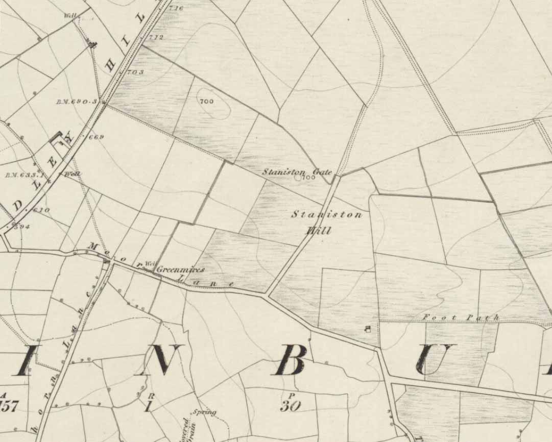
Staniston Hill on 1851 map
This long-lost standing stone gave its name to the small hill between the geological giants of Little Almscliffe and Almscliffe Crags, ‘Staniston Hill.’ Described as early as the 13th century in the Cartulary of Fountains Abbey as ‘Standandestan’, its precise whereabouts is unknown—but it’s damn close to the grid-reference cited here. As the early OS-map shows, a small rounded hill occurs a short distance northwest of the small copse of trees now growing. The monolith may have been felled by some grumpy christian, or it could be standing in some nearby walling. Local antiquarians, dowsers or archaeologists may or may not find a search for it worthwhile…
Its position between the two Almscliffe Crags makes it very close to marking the midway point of a natural solstice marker: the Winter sunrise from Little Almscliffe and summer sunset from the greater Almscliffe.
References:
Bennett, Paul, The Old Stones of Elmet, Capall Bann: Milverton 2001.
Smith, A.H., The Place-Names of the West Riding of Yorkshire – volume 5, Cambridge University Press 1961.
Plan of Rudston D Cursus & associated monuments (after I.M. Stead 1976)
To the north of Rudston village and its giant standing stone, running roughly parallel with the divinatory waters of the Gypsey Race river and passing a mass of prehistoric remains en route, we find one the biggest prehistoric cursus monuments in the British Isles: the Rudston D cursus. More than twice as long as any of the three other cursus monuments nearby, its northern end or ‘terminal’ is flattened in nature (others are rounded) and is due east of the village of Burton Fleming starting at the intriguingly-named Maidens Grave field, just as the land begins to rise at TA 099 717. From here it begins its almost southern trajectory and runs almost dead straight for several hundred yards until edging, ever so slightly in direction, to a slightly more secure southern alignment. Past the site of the Rudston henge, the cursus broadens out slightly and, as it reaches the farmlands of Littlethorpe, edges slightly further to a more decisive direct southern route. The cursus then maintains a dead straight course for another mile, heading straight for, and stopping just short of the Rudston monolith in its modern churchyard. A short distance before we reach its southern end, archaeologists found that a section of the Cursus C monument cut right across it. Altogether, the Rudston D Cursus is more than 4km (2.3 miles) long! At its narrowest width, this monument is a mere 160 feet (50m) across, and at its widest is 280 feet (90m). A giant by anyone’s standard!
Along the entire length of this continuous ditch and inner bank there were just 3 small cuttings on the western side and three on the east, but two of the eastern openings were quite large. Some of these openings were affected by natural elements and others by modern agriculture. Today, much of this gigantic ritual monument (as the archaeologists call them) is not visible at ground level.
In visiting this area, make yourself aware of the other monuments in this class: the Rudston A cursus and Rudston B cursus, southeast and southwest of here respectively. A full multidisciplinary analysis of the antiquities in this region is long overdue. To our ancestors, the mythic terrain and emergent monuments hereby related to each other symbiotically, as both primary aspects (natural) and epiphenomena (man-made) of terra mater: a phenomenon long known to comparative religious students and anthropologists exploring the animistic natural relationship of landscape, tribal groups and monuments.
References:
Burl, Aubrey, Rites of the Gods, J.M. Dent: London 1981.
Harding, Jan, ‘Pathways to New Realms: Cursus Monuments and Symbolic Territories,’ in Barclay & Harding, Pathways and Ceremonies: The Cursus Monuments of Britain and Ireland, Oxbow: Oxford 1999.
Loveday, Roy, Inscribed Across the Landscape: The Cursus Enigma, Tempus: Stroud 2006.
Pennick, Nigel & Devereux, Paul, Lines on the Landscape, Hale: London 1989.
Stead, I.M., ‘La Tene Burials between Burton Fleming and Rudston,’ in Antiquaries Journal, volume LVI Part II, 1976.
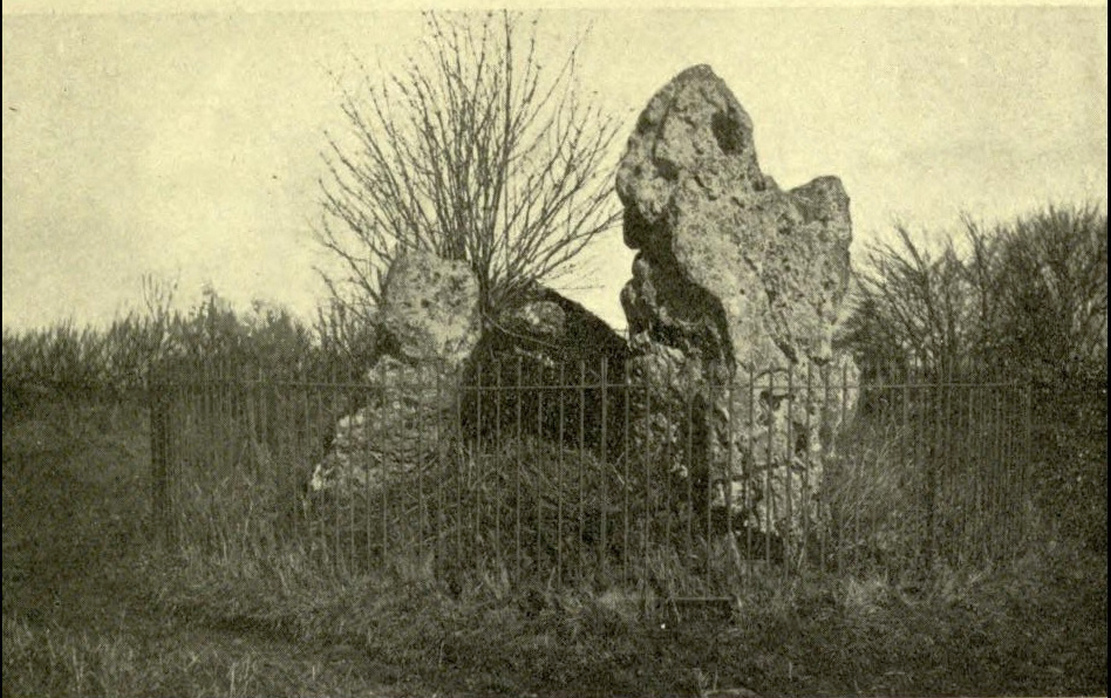
Follow the directions to reach the Rollrights stone circle, from Chipping Norton. Walk past the entrance to the circle along the road for a coupla hundred yards, keeping your eyes peeled looking into the field on your right. You’ll notice the large rocky mass of these Knights a hundred yards down in the field, which can be reached by a footpath running straight along the old hedge from the roadside straight to the collapsed tomb.
Archaeology & History
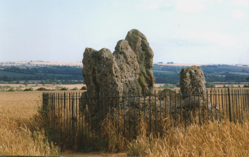
The Whispering Knights
A brilliant site—albeit nowhere like how it once was—where I slept a few times when I lived in the old hut at the Rollright stone circle down the road. A field-mouse lived here when I slept at the place and, hopefully, its ancestors still reside hereby (Rollright Trust’s poisons notwithstanding!). On my first encounter with the little fella, I felt him running into my waist-side whilst laying, dozing in the old tomb. He nudged into me—then again —and yet again; before I leaned over to see what was going on! And the little mouse looked up at me, without a care in the world, as if to say, “What are you doing lying on my path!? Can I get past please?” (though I’d not had a bath for a good 3 months, so didn’t smell like any modern human, which I think explained his total lack of fear)
Laying there, I smiled at the little fella, who then decided to jump up the side of my waist and walk over the top of me to get to the other side! He jumped down into the grasses and disappeared! However, a few minutes later, I felt another tiny ‘thud’ at my side and looked down to see the same lovely mouse wanting to go back along his obviously traditional route – and looking up at me again, whiskers twitching inquisitively, realised I was still here; and so once again took it upon himself to climb over the scruffy smelly human-sort who was blocking his route!
He was a gorgeous little mouse and we got to know each other quite well over the unwashed springs and summers I slept here….. But anyway, that’s not what you folks are interested in hearing about! Back to the archaeo-shit….
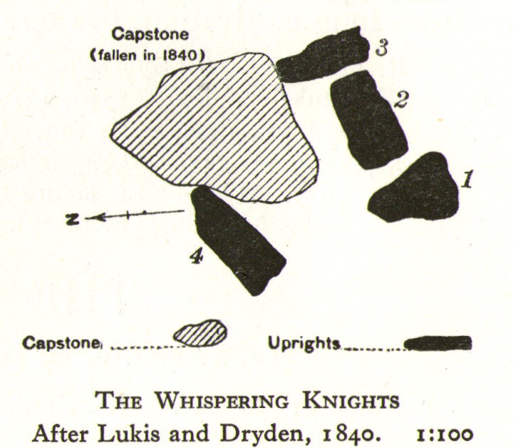
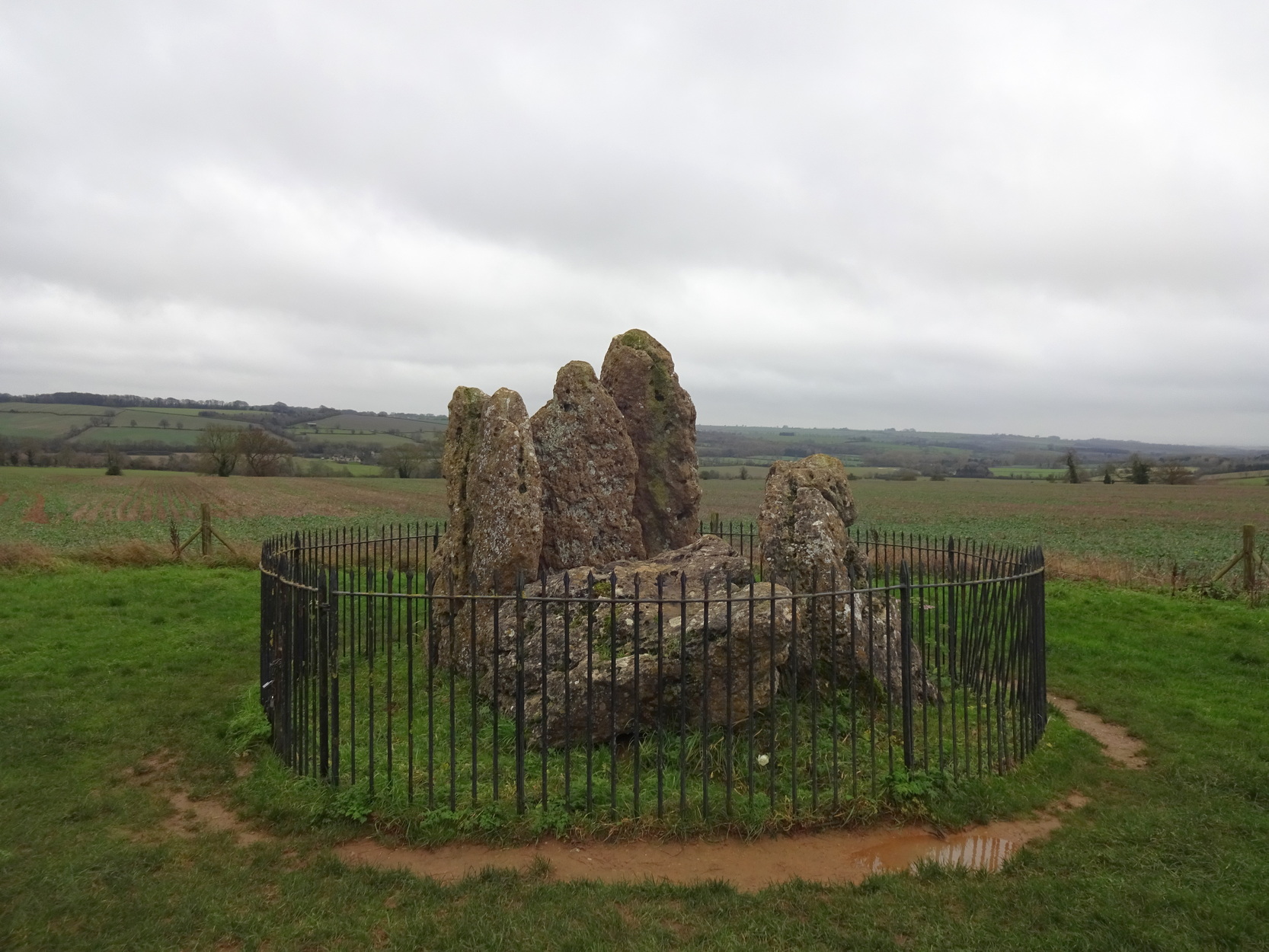
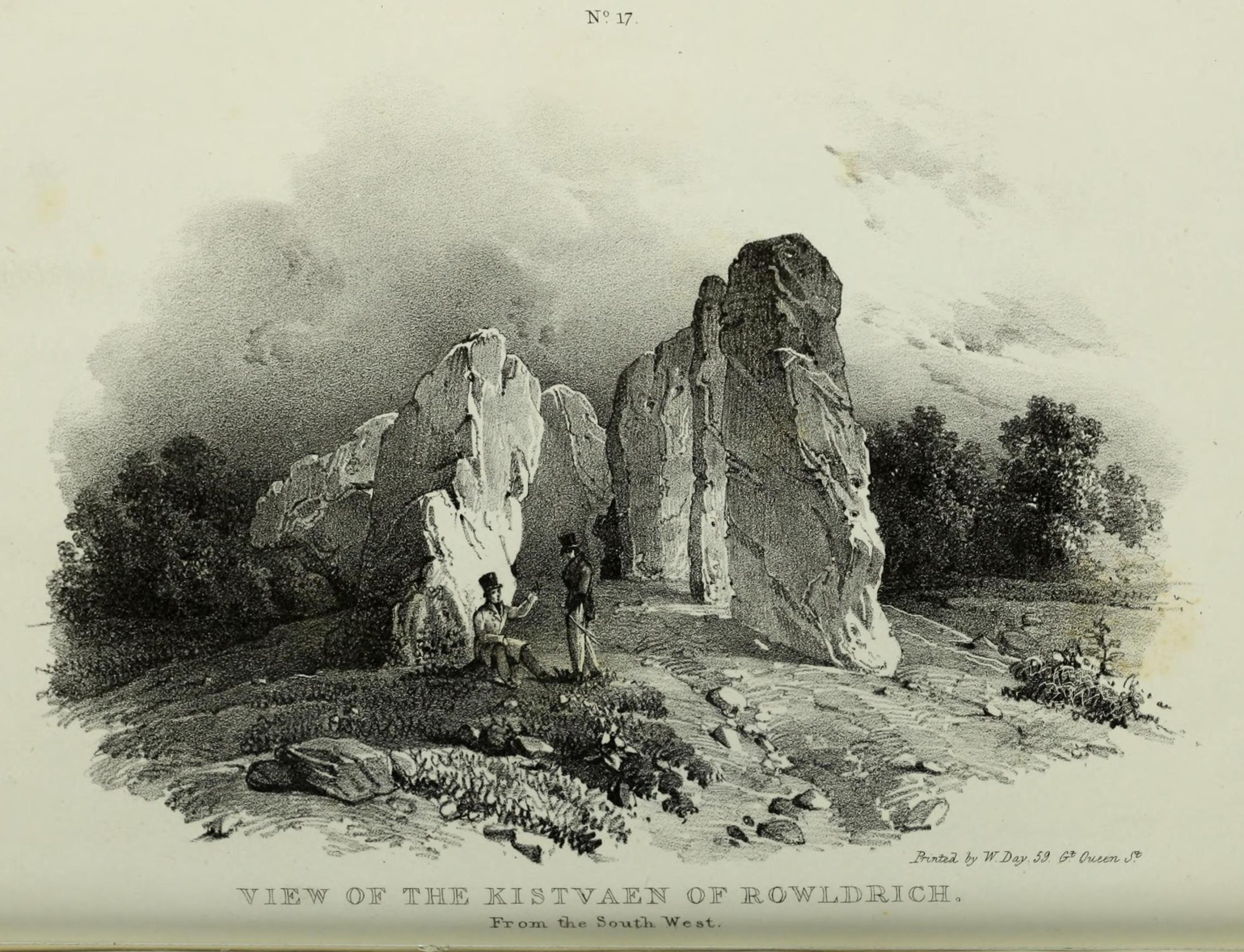
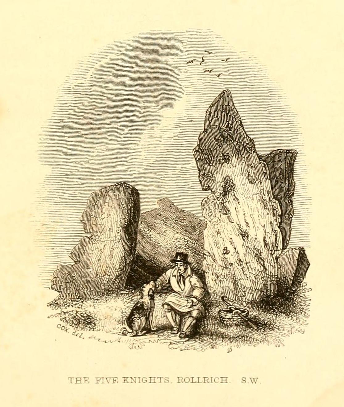
The Whispering Knights is one of the main sites in the cluster known collectively as the Rollright Stones, which also comprises of the standing stone commonly called the King Stone, plus the King’s Men stone circle a coupla hundred yards down the road from the Knights. They all sit atop of the ridge which separates the counties of Oxfordshire and Warwickshire along the edge of the prehistoric road known as the Jurassic Way. The sites are non-contemporaneous having been erected over a period of many centuries. The Whispering- or Five Knights are by far the oldest part of the complex dating from a period never previously anticipated. They comprise of four upright megaliths in close proximity, and a fifth fallen stone which is said to be the capstone on the original monument. This stone alone weighs some 10 tons.
The general archaeological opinion is that the place is a ‘portal dolmen burial chamber’ of which the capstone has fallen. The Oxford archaeologist George Lambrick (1988) postulated the stones to have been covered with a mound of earth, but any evidence supporting this has long since gone.
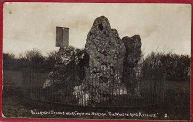
1920s postcard of the siteThe Knights in 1995
This great monument was initially thought by archaeologists to have been built sometime around 1800 BCE—a favourite date of academics for many an unexcavated site for many decades—until they turned their astute attention to the place in the 1980s. And what they found was astonishing. Well…astonishing for the archaeologists! Affirming the local folk tradition that the Knights were the “oldest monuments in Oxfordshire,” the dates truly went back. Way back! Datable remains at the site gave results from between 3500 and 3800 BCE: two thousand years earlier than anyone had ever expected of them.
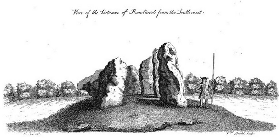
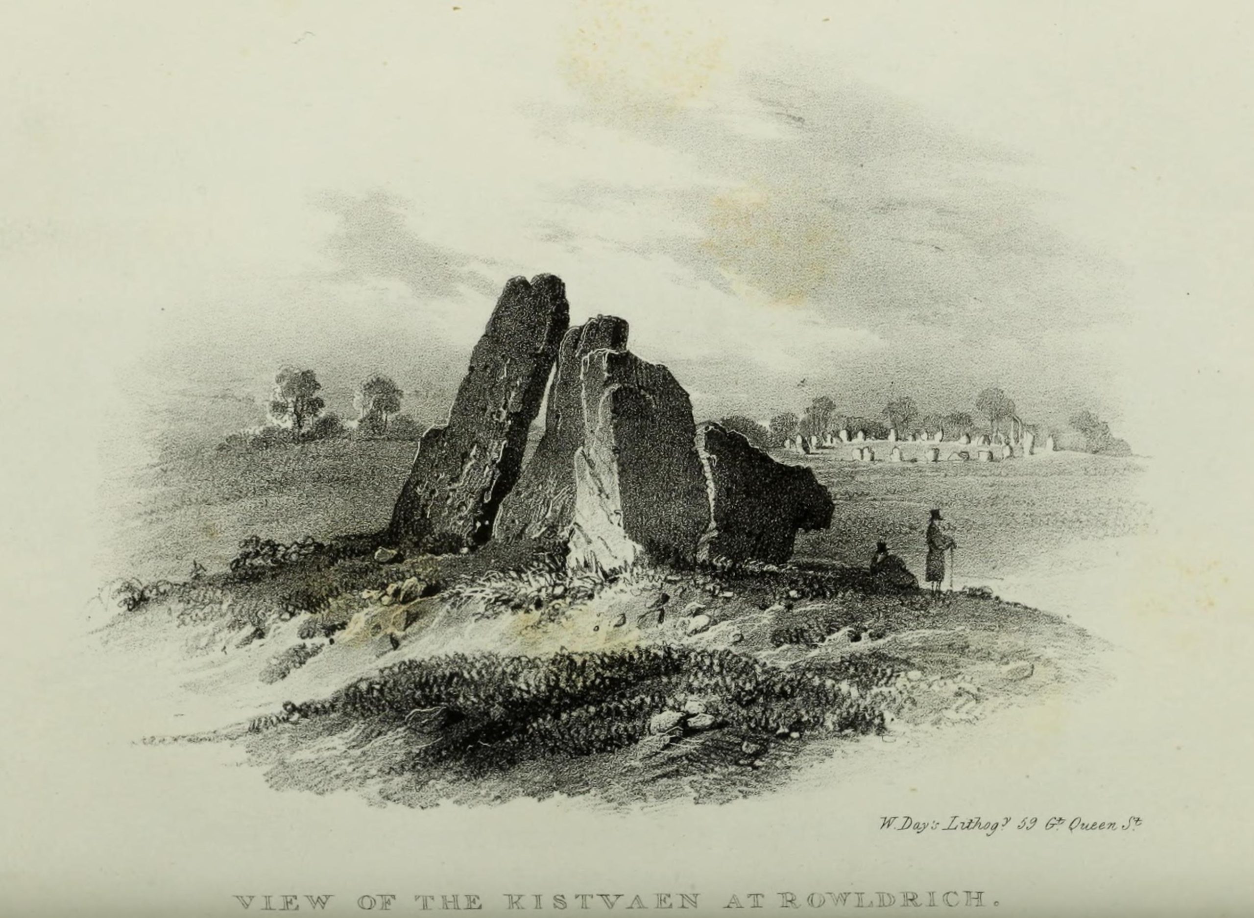
Although five stones remain of the site, when the great William Stukeley (1743) visited the Whispering Knights, he described six of them to be visible with the great stones here to be sat upon a tumulus, saying:
“Tis composed of six stones, one broader for the back part, two and two narrower for the sides, set square to the former; and above all, as a cover, a still larger. The opening is full west to the temple or Rowldrich. It stands on a round tumulus, and has a fine prospect southwestward down the valley, where the head of the Evenlode runs.”
O.G.S. Crawford (1932) told us of a description which Sir Henry Dryden gave of the Knights in 1898, when he wrote:
“About 356 yards E from the (Rollright) circle and S of the road, is the dolmen about to be described, called the Five Whispering Knights. It is in a ruinous state. It now consists of four stones, upright, or nearly so, and one prostrate, all of coarse limestone…
Height, 8ft 3ins (4ft by 2ft 6ins)
” , 7ft 3ins (3ft 6ins by 1ft 10ins)
” , 6ft 7ins (3ft 8ins by 1ft 4ins)
” , 5ft 4ins (4ft 9ins by 2ft)
Capstone (then fallen), 8ft 4ins by 5ft 9ins, by 2ft 4ins
“The chamber appears to have been about 5 feet 6 inches W and E, and the same N and S. If, as usual, there was an entrance, with or without a passage, it was probably to the ENE… There is not, so far as I know, any record of remains having been found in this dolmen. In a small stone pit about 700 feet NE by E from the circle it is stated that 12 skulls were found in 1835. In another stone pit near it was found in 1836 an urn and beads…”
1840 plan by Lukis & Dryden
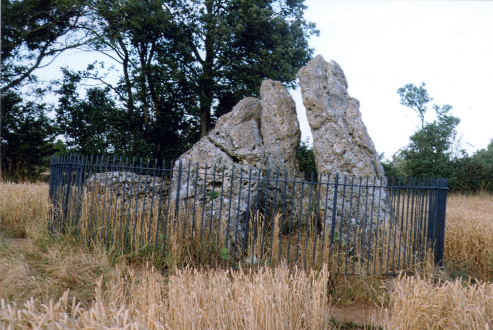
During the last century, very little has really changed at the Knights. The ring fencing surrounding the stones has kept it pretty much protected, despite it ruining all sense of healthy ambience. But they have gained greater and greater attention the older they have got. Archaeologists are not the only ones exploring the site. Fascinated astronomers, engineers and architects have been and seemingly uncovered other mythic ingredients here.
Whispering Knights, 2016
When the legendary Alexander Thom came here, he used the archaeological data that was being espoused at the time, which said the Knights and the Rollright stones had both been built around 1750 to 1800 BC. With these dates as his guide, he found that someone standing at the centre of the Rollright circle, on the morning of the equinoxes—March 21 and September 21—the sun would rise right above the Whispering Knights. And the effect, he thought, was a notable one: with the light from the rising sun going straight through a hole in one of the stones in the circle as it rose up behind the Knights. It would have looked both spectacular and eerie in the rising mists of first light, like a laser cutting through the still morning air… However, although Thom’s measurements were very accurate, the archaeologists had got their dates wrong. Very wrong! For the Whispering Knights were about 1500 years older than the stone circle—and so the alignments Thom pronounced, based on the archaeologist’s erroneous proclamations, were also incorrect.
There may be other alignments connected to the Rollright complex. In a survey of the site as part of the Dragon Project experiments conducted here in June 1980, Leslie Banks and Christopher Stanley flew over the place and found, adjacent to the Whispering Knights, a quite distinct “trace of two dark green parallel lines in a field of ripening corn” running northwest to the roadside. To this day nobody quite understands the nature of this enigmatic alignment:
“In the absence of excavation we can only speculate,” said Stanley. “But the most likely explanation is that it is what archaeologists refer to as a Cursus. Cursuses are thought to be prehistoric religious processional ways.”
As with many of the alignments described here, the jury is still out on this one!
Folklore
Whispering Knights, 1829
The folklore here is prodigious! The prime story of the neolithic tomb of the Whispering Knights tells that originally they were in fact a group of traitors who moved away from a King and his army in ages past, and who were plotting against him, when the great Witch of Rollright (a southern version of the great cailleach, found in more northern counties, Scotland and Ireland) turned them all to stone (this tale is intimately bound up with the King’s Men stone circle and the associated King Stone).
Whispering Knights, 1841
Another tale tells how the King Stone and the Whispering Knights venture, at midnight, less than half a mile south to drink from a spring in the small woodland at Little Rollright Spinney, although it is difficult to ascertain precisely which of the two springs the stones are supposed to visit. In some accounts, the stones reputedly drink from the well every night, but others tell that they only go there at certain times of the year, or on saint’s days. When Arthur Evans (1895) wrote of these tales he described there being a “gap in the bushes… through which they go down to the water,” but the terrain has altered since his day.
Other accounts imbuing the stones with life tell how they only ‘awaken’ when disturbed by humans. A story well-known to local people is that of when the Knights had its capstone removed one day by a farmer who used it to build a bridge across the stream at Little Rollright. As Evans told us,
“it took a score of horses to drag it down the hill, for at first it would not move, and they had to strain and strain to get it along till every bit of the harness was broken. At last they got it to the brook by Rollright Farm, and with great difficulty laid it across to serve as a bridge. But every night the stone turned over back again and was found in the morning lying on the grass.”
Three nights of this led the farmer to think he should replace the stone which, so the fable goes, took only one horse to move it back uphill and into position. A variation of the same tale was told by T.H. Ravenhill, who wrote:
“The Lord of the Manor of Little Rollright desired to possess the King’s Stone in order to bridge Little Rollright brook. So he dug it up and tried to cart it away, but found that he had not enough horses. He hitched on more, and yet more, and still he found that he could not move the stone. Finally he succeeded and hauled the stone away to the Manor House. The same night he was alarmed by strange sounds about the house, which he attributed to the presence of the King’s Stone, and decided, therefore, to replace it on its mound. No sooner had he harnessed the first horse to the cart than it galloped away up hill with ease, taking with it the stone, which leapt to position on reaching its resting place.”
There are still more variations that are worth mentioning. One from 1876,
“said that a miller in Long Compton, thinking the stone would be useful in damming the water of his mill, carried it away and used it for that purpose, but he found that whatever water was dammed up in the day disappeared in the night, and thinking it was done by the witches (at Long Compton) and that they would punish him for his impertinence in removing the stone, he took it back again; and, though it required three horses to take it to Long Compton, one easily brought it back.”
In yet another version, the stone was wanted by a local farmer for his outhouse. In taking it downhill, the horses that pulled his wagon died and the vehicle itself was irreparably damaged. It got even worse for the poor chap: his crops failed, his family were taken ill and his cattle died. Eventually when all but his last horse remained, he made another cart and it pulled the stone back uphill with ease. Thereafter, so the tale goes, all his adversities stopped and he lived a normal life. In one version of this tale, the great monolith was said to have been taken north-north-west down to the stream at The Hollows, Long Compton. Tales such as these are, once more, found throughout the world.
The truth of these stories was seemingly unquestionable to some local people in the 19th century,
“one man going as far as to say that there were those now living who had spoken to men who had helped to bring the stone down and up again.”
In William Stukeley’s day, one Farmer Baker was so troubled by his actions that he couldn’t rest until he returned the old stone.
The doyen of the early geodelic sciences or Earth Mysteries movement, John Michell, suggested how the legends of megaliths moving of their own accord harked back to ancient days when the people of those times were more attuned to the terrestrial magnetic flows of the Earth.
The Whispering Knights were also a place where “young girls of the neighbourhood (use it as) a kind of primitive oracle.” One local told Arthur Evans that around barley harvest the young women of the district visited the Five Knights to listen to them whisper. One at a time they would rest their ears against the strange shapes of stone and, if fortune and conditions were right, they would hear the future told. This mass of animistic lore is very revealing indeed, telling us much about the way our peasant ancestors viewed the living world around them. (Eliade 1958)
In more recent times, the site has been explored by dowsers and ley hunters, who claim to have found a veritable bags of fascinating lost material around the Knights. Although originally ‘leys’ were described by Alfred Watkins as quite acceptable prehistoric trackways linking site to site to site, in recent years the original theory has been ignored and superceded with a host of almost incredulous fluctuations. Leys these days can run just about anywhere – and do!
One writer who tells about the leys around Whispering Knights is Lawrence Main. (1997) He dowsed and found a ley running south to the famous White Horse at Uffington. Roy Cooper (1979) was the first person to write about this alignment and extended it further north to the impressive and legendary Brailles Hill. That one seems reasonable. However,
“Other leys I dowsed,” said Main, “Linked the King Stone, the stone circle, and the Whispering Knights with each other; the King Stone with Banbury Cross; the Whispering Knights with Hook Norton church; and the stone circle with the churches at Todenham and Stretton-on-Fosse.”
Another dowsing ley hunter is Dennis Wheatley (not The Devil Rides Out dood). He wrote a couple of short works on his lengthy experiments at the Rollright stones and reported how he found a
“tangential aerial energy course…across the country (which) latches on to a solitary standing stone, six miles south, known as the Hawk Stone.”
Perhaps of greater importance here is that Wheatley also discovered how,
“all of the Rollright ring’s stones engage in aerial energetic cross-talk with the King Stone producing a triangulation of energy lines.”
This cross-talk of Wheatley’s involves more than seventy energy lines running between the circle and the King’s Stone. He tells us that a greater “aerial cross-talk” also occurs between the circle and the Knights; and “a lesser energetic triangulation” runs between the King and the Knights.
Along similar lines are the findings of the dowser Reginald Smith. (1980) Beneath the Whispering Knights he claimed to have found,
“a concealed spring which runs underground to the northwest and may betoken a consecrated site; but 100 feet to the east there seems to be another blind spring with issue to the northeast.”
References:
Bennett, Paul & Wilson, Tom, The Old Stones of Rollright and District, Cockley Press: London 1999.
Burl, Aubrey, Great Stone Circles, Yale University Press: New York & London 1999.
Cooper, Roy, ‘Some Oxfordshire Leys,’ in The Ley Hunter 86, 1979.
Crawford, O.G.S., Long Barrows of the Cotswolds, John Bellows: Oxford 1932.
Devereux, Paul, Places of Power, Blandford: London 1990.
Devereux, Paul, The Sacred Place, Cassell: London 2000.
Eliade, Mircea, Patterns in Comparative Religion, Sheed & Ward: London 1958.
Evans, Arthur J., ‘The Rollright Stones and their Folklore (3 parts),’ in Folklore Journal, 1895.
Gelling, Margaret, The Place-Names of Oxfordshire – volume 2, Cambridge University Press 1971.
Graves, Tom, Dowsing: Techniques and Applications, Turnstone: London 1976.
Grinsell, Leslie V., The Ancient Burial Mounds of England, Methuen: London 1936.
Lambrick, George, The Rollright Stones: The Archaeology and Folklore of the Stones and their Surroundings, Oxford Archaeology Review 1983. (Reprinted and updated in 1988.)
Main, Lawrence, Walks in Mysterious Oxfordshire, Sigma: Wilmslow 1997.
Ravenhill, T.H., The Rollright Stones and the Men Who Erected Them, Little Rollright 1926.
Robins, Don, Circles of Silence, Souvenir Press: London 1985.
Smith, Reginald A., ‘Archaeological Dowsing,’ in Graves, Tom (ed.), Dowsing and Archaeology (Turnstone: Wellingborough 1980).
Stanley, Christopher C., ‘A Rollright Processional Way?’ in The Ley Hunter 90, 1981.
Stuart, Sheila, Lifting the Latch, Oxford University Press 1987.
Bittova journey this — but well worth it! From Broughton-in-Furness take the A595 road west, past Duddon Bridge for about another 1½ miles, turning right up the small single-track country lane beloved of city-mind drivers, up the fertile scruffy road, past Broadgate and stopping just before Cragg Hall Farm. There’s a dirt-track running up the back of Cragg Hall. Go up here and keep walking for a mile or so until, as you approach Swinside Farm and the fields open up in front of you, the stones begin to appear.
Archaeology & History
Swinside, looking east
The Swinside stone circle is Aubrey Burl’s favourite. And for good reason! Like other impressive megalithic rings of the region, the stones are large, well set, and the landscape holds the stones finely in the hills. Without the landscape here, Swinside (like Castlerigg and elsewhere) would not have such grandeur. When you sit in the ring, or walk round it, Knott Hill to the south was of obvious mythic relevance to the people who built this stone circle four or five thousand years ago. But this can be said of many of the surrounding crags. A few miles southwest we see the top of the haunted Black Combe rising into clouds, still speaking to some with spirits from animistic realms, long known to our ancestors. Following the skyline west and past the small falls of Whicham stream, whose name speaks of long past trees, we reach the near-west skyline with the cairn-looking pap of the Raven Crag, symptomatic of magickal rites calling to and beyond the circle. To the north is the symbolic ridge of Lath Rigg. Along the craggy eastern ridges from here you get the impression that you’re more in Argyll than Cumbria; and the break in the hills to the southeast reaches to the distant pinnacle of Kirkby Moor, where the midwinter sunrise emerged to tell of solar calendrical motions and the coming of the dark season to our megalithic tribes. But enough of the landscape!
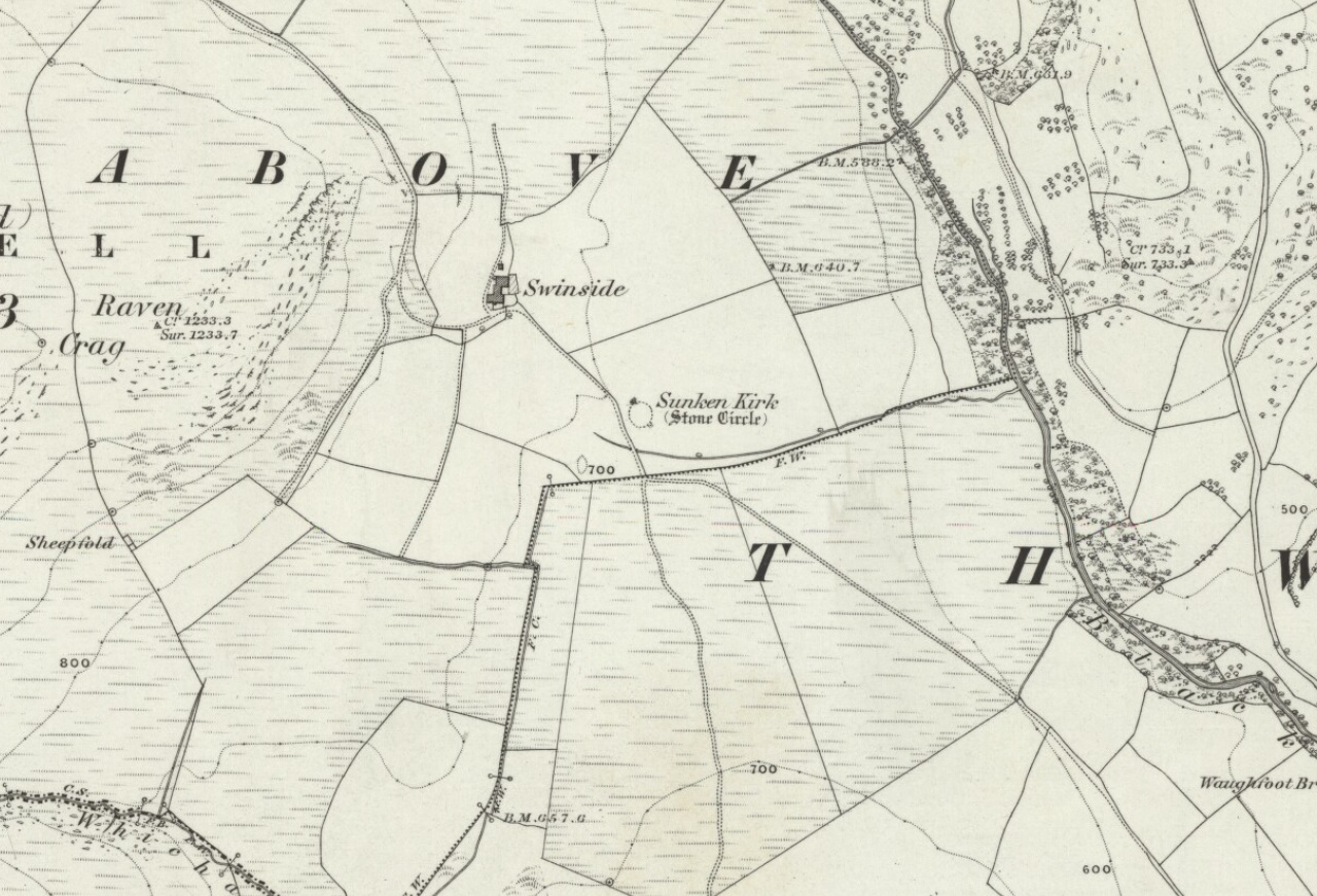
Swinside on 1867 OS-map
Although the name Swinside can be traced back to the 13th century, the local folk-name of the circle—Sunken Kirk—was mentioned for the first time as “the Chapell Suke” in Parish Registers of 1624. No earlier literary source has yet been identified, probably because of the isolation of the site and the lack of people writing about the area. Swinside stone circle is, just about, a perfect circle, give or take a foot here and there, holding the circular dome of the heavens within its domain. Yet despite its almost regal appearance, early references to the site seem scant. It seems to have been first described in William Hutchinson’s huge History of Cumberland (1794), where he told:
“In the neighbourhood of Millum, at a place called Swinside, in the estate of William Lewthwaite Esq., of Whitehaven, is a small but beautiful druidical monument; it is circular, about twenty eight yards in diameter; the stones of which it is composed are from six to eight feet high, all standing and complete. A little to the south, is another of larger dimensions, but not in so perfect a state: the neighbouring people call those places by the emphatical names of Sunken Kirks.”
A few years later, William Camden’s legendary text Britannia was edited and reprinted again, this time by Richard Gough (1806), who told:
“At Swineshead, a very high hill…is a druidical temple, which the country folk call Sunken Kirk, i.e., a church sunk into the Earth. It is nearly a circle of very large stones, pretty entire. No situation could be more agreeable to the Druids than this; mountains almost encircle it, not a tree is to be seen in the neighbourhood, nor a house, except a shepherd’s cot at the foot of a mountain surrounded by a few barren pastures. At the entrance are four large stones, two placed on each side at the distance of six feet. The largest on the left hand side is five feet six inches in height, and ten feet in circumference. Through this you enter into a circular area, 29 yards by 30. This entrance is nearly southeast. On the north or right-hand side is a huge stone of conical form, in height nearly nine feet. Opposite the entrance is another large stone which has once been erect, but is now fallen within the area: its length is eight feet. The left hand or southwest is one, in height seven feet, in circumference 11 feet nine inches. The altar probably stood in the middle, as there are some stones still to be seen, though sunk deep in the earth. The circle is nearly complete, except on the western side some stones are wanting. The largest stones are about thirty one or two in number. The outwards part of the circle upon the sloping ground is surrounded with a buttress or rude pavement of smaller stones raised about half a yard from the surface of the Earth… This monument of antiquity, when viewed within the circle, strikes you with astonishment, how the massy stones could be placed in such regular order either by human strength or mechanical power.”
Tall, northernmost stone to centreNortheast section of the ring
It seems he was impressed! Yet despite this, in the 19th century not many folk strayed this far into the western edges of Lakeland to look upon Swinside. There were occasional descriptions from travellers and antiquarians such as J.T. Blight (1843) and Edwin Waugh (1861), each speaking of the site’s visual magnitude, but it wasn’t until archaeologist C.W. Dymond came here, first in 1872 and then again in 1877, that a fuller account of the site came into being. In his essay on a “Group of Cumberland Megaliths,” he said how the stones were still in excellent condition and that,
“few of the stones seem to have been removed — probably because plenty of material for walling and road-making could be collected from the neighbouring hillside.” (Dymond 1881)
When Mr Dymond first came here he told of the remains of a rowan tree which had split one of the stones, but this has long gone. More than twenty years after the archaeologist’s first visit, he returned with R.G. Collingwood to make a more detailed evaluation of the ring. He measured and planned Swinside like it had never been done before and his ground-plan (below) is still very accurate indeed. Aubrey Burl (1999) takes up the story:
“The ring was partly excavated by Dymond, Collingwood and three men from midday Tuesday, 26 March 1901, until the close of the following evening. They dug two long, intersecting 46cm-wide trenches, NW-SE, NE-SW, across the ring with a curious zigzagging pattern of others between southeast and southwest: an investigation of some 51m² of the central area. Within the circle the trenches represented less than a thirteenth of the 642m² of the interior.
“Below the grass and turf was a thin layer of soil under which yellowish marl or ‘pinnel’ varied from 15cm to 75cm in depth, being deepest at the entrance which had been dug into earlier around 1850. Wherever it was uncovered the gravelly marl was wavily uneven, presumably the result of ploughing. The bases of the circle-stones rested on the pinnel, held firmly in their holes by small cobbles with others heavily packed around the sides. The only finds were a nut-sized lump of charcoal just northeast of the centre with others near the entrance; a minute splinter of decayed bone near the first bit of charcoal and two pieces of red stone. There were also some contemporary glass sherds and a Lancaster halfpenny dated between 1789 and 1794 lying in the uppermost turf layer.”
Dymond’s 1881 plan of Swinside
Since these early archaeological digs, Swinside has given up little else. Much like other stone circles in the British Isles, few real clues as to exactly what went on here have been forthcoming. But in the 1960s, investigations into megalithic sites made a bit of a quantum leap and some old ideas about astronomical ingredients were resurrected.
Alexander Thom’s plan of Swinside
Swinside was one of the places explored by engineer and megalith enthusiast, Alexander Thom. Thom was one of the prime figures instrumental in the resurgence of interest in megalithic sites — and his finds of megalithic astronomy and prehistoric mathematics had a lot to do with it. Although we know today that some of Thom’s work isn’t correct, his explorations and research stand him far ahead of most archaeologists who pretended to represent this area of research. He left us with the most detailed ground-plans of megalithic sites to date and, of course, showed some fascinating alignments.
Thom listed Swinside as site “L1/3” and made the most detailed and accurate ground-plan of this and 18 other megalithic rings in Cumbria. He found it to be 94 feet in diameter, with an internal area measuring 6940 square feet. The one major alignment Thom found at Swinside was of the winter solstice sunrise, lining up just on the edge of the ‘entrance’ to the circle’s southeastern side.
Folklore
Like a number of other stone circles, folklore told that you couldn’t count the stones. Janet and Colin Bord (1997) also told that people once tried to build a church here in early christian days, but once the builders went home in the evening, the Devil pulled down what they’d built during the day. A motif found at Ilkley’s Hanging Stones cup-and-ring carvings and many other prehistoric sacred sites in the country.
References:
Armstrong, A.M. et al., The Place-Names of Cumberland – volume 2, Cambridge University Press 1950.
Bord, Janet & Colin, Prehistoric Britain from the Air, Weidenfeld & Nicolson: London 1999.
Burl, Aubrey, “‘Without Sharp North…’ – Alexander Thom and the Great Stone Circle of Cumbria”, in Ruggles, Clive, Records in Stone, Cambridge University Press, 1988.
Burl, Aubrey, A Guide to the Stone Circles of Britain, Ireland and Brittany, New Haven & London 1995.
Burl, Aubrey, Great Stone Circles, Yale University Press: New York & London 1999.
Burl, Aubrey, The Stone Circles of Britain, Ireland and Brittany, Yale University Press 2000.
Dymond, C.W., “A Group of Cumberland Megaliths,” in Transactions of the Cumberland and Westmorland Antiquarian and Archaeological Society, volume 5, 1881.
Dymond, C.W., “An exploration at the Megalithic Circle called Sunken Kirk at Swinside, in the Parish of Millom, Cumberland,” in Transactions of the Cumberland and Westmorland Antiquarian and Archaeological Society, New Series volume 2, 1902.
Gough, Richard (ed.), Camden’s Britannia, J. Nichols and Son: London 1806.
Hutchinson, William, The History of the County of Cumberland – volume 1, F. Jollie: Carlisle 1794.
Seton, Ray, The Reason for the Stone Circles in Cumbria, R. Seton: Morecambe 1995.
Thom, Alexander, Megalithic Sites in Britain, Oxford University Press 1967.
Thom, A., Thom, A.S. & Burl, H.A.W., Megalithic Rings, BAR: Oxford 1980.
Waterhouse, John, The Stone Circles of Cumbria, Phillimore: Chichester 1985.
Waugh, Edwin, Seaside Lakes and Mountains of Cumberland, Alexander Ireland: Manchester 1861.
ACKNOWLEDGEMENTS:
Huge thanks to Brian Else for his photos. And to Paul and Tricia for taking us here, in awesome downpour weather!
One of the four (known) cursus monuments around Rudston: this one stretches between the Ordnance Survey coordinates TA 081669 near Kilham Grange on the southwestern edge of Rudston, then heads northeast towards the village itself at TA 094675. Described briefly in D.P.Dymond’s essay on (mainly) Cursus A, he said how Cursus B was part of,
Early ground-plan (after D.P. Dymond)Early photo of Rudston B (after J.K.St Joseph)
“a large complex of crop marks. The largest feature is the squared, tapering end of Cursus B, which can be traced for 700 yards in a north-easterly direction. No surface remains seem to survive in an area intensively ploughed, except for a swelling under a hedge on the line of the south-eastern bank (at TA 0834 6703). West of the square end and partly overlying it, are several small rectangular enclosures, which are probably part of a later (?Romano-British) settlement and field-system. Also in this tangle of crop-marks there are four roughly circular shapes, which may well be barrow circles associated with the end of the cursus. On certain barrow just south of the end of the cursus has an inner ring of pits. Where the cursus is lat visible to the north-east, it is headed roughly for the monolith ¾-mile away. The width of Cursus B is approximately 90 yards between ditch centres. It has its square end on the forward slope of a ridge (like Cursus A) at a height of 180 feet OD, and descends towards the village, which is visible from the end, through a shallow valley.”
Dymond’s note about the alignment feature of this cursus, towards the gigantic Rudston monolith, was one echoed in the Hedges & Buckley (1981) survey. They noted:
“At Rudston, the B cursus extended eastwards aligns upon the Rudston monolith in Rudston churchyard. Destruction of standing stones elsewhere may have removed similar associations between the stones and cursuses.”
This alignment feature was also confirmed by cognitive archaeologist and alignment specialist, Paul Devereux (Pennick & Devereux 1989) in his survey of cursus monuments.
Typical of these fascinating antiquities, nothing of any worth has been found along the length of the cursus that can give us any clues to its nature and function. However, the presence of this and three others close by indicates that the region was an exceptionally important one in the cosmology of our prehistoric ancestors. Four of these giant linear cursus monuments occur in relative proximity, and there was an excess of ancient tombs and, of course, we have the largest standing stone in the British Isles stood in the middle of it all. A full multidisciplinary analysis of the antiquities in this region is long overdue. To our ancestors, the mythic terrain and emergent monuments hereby related to each other symbiotically, as both primary aspects (natural) and epiphenomena (man-made) of terra mater: a phenomenon long known to comparative religious students and anthropologists exploring the animistic natural relationship of landscape, tribal groups and monuments.
References:
Dymond, D.P., “Ritual Monuments at Rudston, E. Yorkshire, England,” in Proceedings of the Prehistoric Society, volume 32, 1966.
Eliade, Mircea, The Sacred and the Profane, Harvest: New York 1959.
Hedges, John & Buckley, David G., The Springfield Cursus and the Cursus Problem, Essex County Council 1981.
Pennick, Nigel & Devereux, Paul, Lines on the Landscape, Hale: London 1989.
From Port Ellen take the A846 road east to Laphroaig, and on the far side of the village, past the small forested part on your left, walk up the slightly sloping hill alongside the small River Kilbride. Over a couple of walls on your way up, look up the small hill to your right (north) and you’ll see these large standing stones.
Archaeology & History
A triple-stone row no less! Although only two of these stones are upright, a third central prostrate stone is included in archaeological surveys as an original upright. And it seems likely. Although passed over in Alexander Thom’s astroarchaeological analyses, Clive Ruggles (1984) looked at this stone row and found the alignment here to possess no solar or lunar function. But if it aligns north the mythic relationship obviously relates to death, as North “is the place of greatest symbolic darkness” where neither sun nor moon ever rise nor set. There may have been an early association with Alpha Draconis, or Thuban in the constellation of the Dragon: the Pole Star in early neolithic times around which the heavens were seen to revolve by our ancestors and hold the pillar of the sky in place. But we may never know. Perhaps by the time these monoliths were erected, the mythos relating to A.Draconis may have faded…
The stones are found amidst a scatter of other neolithic and Bronze Age remains. In the Royal Commission (1984) report on the stones they described the respective monoliths as follows:
“The north stone, measuring 1.28m by 0.35m at the base and 2.70m in height, rises with a gradual taper, the top curving gently to its highest point at the top of the south side. The centre stone, now prone, has fallen onto its E face and lies embedded in the ground with its upper surface (originally the west face) flush with turf; it is 3m long and up to 0.9m broad. The south stone measures 0.80m by 0.40m at the foot and 2.85m in height. It leans towards the west and the top slopes down sharply from the south to a shoulder 2.1m above ground level on the north side.”
…to be continued…
References:
Burl, Aubrey, From Carnac to Callanish, Yale University Press 1993.
Royal Commission on the Ancient & Historical Monuments of Scotland, Argyll – volume 5: Islay, Jura, Colonsay and Oronsay, HMSO: Edinburgh 1984.
Ruggles, C.L.N., Megalithic Astronomy: A New Archaeological and Statistical Study of 300 Western Scottish Sites, BAR: Oxford 1984.


")
")

