The site can be approached by going up the almost hidden long steep winding lane off the A646 in Cornholme; but if you don’t know the area it’s probably best approached from the well known Bride Stones, above Todmorden. From here, go west along the road running 100 yards or so above the Bride Stones, past the old pub, past Hawk Stones farm, and turning left downhill about a quarter-mile on. A coupla 100 yards down, there’s a track to your left. As you start walking along you’ll see a standing stone on the grassy rise in front of you on your left. That’s it!
Archaeology & History
Mount Cross on 1848 map
Said by local writer Geoff Boswell (1986) to be “the oldest religious memorial in Todmorden,” this old stone, more than 4-feet tall, is still in good condition and can be found beside the Old Causeway: a prehistoric trackway running between Lancashire and Yorkshire which is said by archaeologists to have been an old, but established trade route. It was suggested by some to have been erected as a cross as early as the 7th century. Generally known as the Mount Cross, it is also known as the Idol Cross, as legend reputes it to have been the site of pagan practices; hence its repute as being haunted. Its alleged heathen history is probably true (history records describe an old “rude stone” that was once found beneath the legendary Bride Stones nearby, which was moved many centuries back).
The Calderdale Council website tells that,
“Towards the bottom of the shaft on the NE side are what appears to be extremely faint traces of vine-scroll decoration which would suggest a fairly early date for the cross, possibly tenth or eleventh century. The irregularity of the carving overall tends to indicate that the cross is no earlier.”
Folklore
Said to have stood upon or beside a small tumulus until the 20th century. Jessica Lofthouse (1976) reported that a local farmer said of this stone. “Queer things happened here long since. They worshipped idols here.” Locally attributed to be haunted, the old stone was said to have a history of “uncanny happenings.”
References:
Bennett, P., The Old Stone Crosses of West Yorkshire, unpublished MS, 1995.
Boswell, Geoff, On the Tops around Todmorden, Delta G: Todmorden 1986.
Lofthouse, Jessica, North Country Folklore, Hale: London 1976.
ON the A59 Harrogate to Skipton road, right on top where it crosses the barren moors, get to the parking spot right near where the road levels out at the highest point (2-300 yards past the turning to the derelict Dovestones Quarry). From here, go thru the gate onto the moor for about 100 yard. Then turn straight east (left) for another few hundred yards till y’ reach the spot marked as Gill Head Peat Moor on the OS-map. This small standing stone (right) is where you need to start – the other remains continue east of here.
Archaeology & History
Richard’s original photo, with walling clearly visible
The discovery of this site began in April 2005, when rock art student Richard Stroud and I were exploring the moors here and he called our attention to what seemed like a singular upright standing stone, some 3 feet high, with a debatable cup-marking on top, standing amidst a scatter of smaller stones running north and south from here, implying that the stone may have been a part of some much denuded walling from our ancient past. But we weren’t sure—and simply noted its location (at SE 13378 54924) and carried on our way. But in revisiting this site after looking at some old archaeology papers, Paul Hornby and I chanced to find a lot more on the burnt heathland running east of here.
The upright stone found by Mr Stroud is certainly part of some ancient walling, but it is much denuded and falls back into the peat after only a short distance. A short distance west of this stone is a small cairn which seems of more recent origin; but due east, along the flat plain on the moorland itself, the burnt heathland showed a scattering of extensive human remains, comprising mainly of walling, hut circles and possible cairns—lots of it!
One issue we have to contend with on this moorland is the evidence of considerable peat-cutting in places, which was being done on a large scale into the Victorian period. Scatterings of medieval work are also found across this moor, in places directly interfering with little-known Bronze Age monuments in the middle of the remote uplands. There is no doubt that some of these medieval and later workings have destroyed some of the uncatalogued prehistoric archaeological remains on this moor. But thankfully, on the ridge running west to east along Gill Head to above the source of the Black Dike, scattered remains of human habitation and activity are still in evidence. The only problem with what we’ve found, is the date…
Two rows of straight walling, with stone scatter all roundAnother overgrown curve of walling
In 1960, Mr J. Davies first mentioned finding good evidence of flint-workings at a site close by; then described his discoveries in greater detail in the Yorkshire Archaeological Journal (1963) a few years later — but contended that the remains were of mesolithic origin. A few years earlier, Mr D. Walker described a similar mesolithic “microlith site” a bit further north at Stump Cross. Earlier still, Eric Cowling (1946) and others had made similar finds on these and adjacent moors. Yet all of them missed this scatter of habitation sites, perched near the edge of the ridge running east-west atop of the ridge above the A59 road. It’s quite extensive and, from the state of the walled remains, seems very early, probably neolithic in origin.
A number of small hut circles, 2-3 yards across, are scattered amidst the heather, with lines of walling—some straight, some not—broken here and there by people who came to gather their peat for fuel. The walling and hut circle remains are very low to the ground, having themselves been robbed for stone it would seem. The area initially appeared to be little more than a mass of stones scattered across the Earth (and much of it is), but amidst this are very clear lines of walls and circles, although they proved difficult to photograph because of the excessive growth of Calluna vulgaris.
Curious man-made structure in dried peat-bog
A couple of hundred yards south there are remains of one of the many dried black peat-bogs—with one large section that has been tampered with by humans at some point in the ancient past. Over one section of it there has been built a small stone path, or possible fish-trap; plus elsewhere is a most curious rectangular walled structure (right) obviously made by people a long time ago. Also amidst this dried peat-bog are the truly ancient remains of prehistoric tree-roots emerging from the Earth, a few thousand years old at least – and perhaps the last remnants of the ancient forests that once covered these moors.
How far back in time do all these walled remains take us? Iron Age? Bronze Age? Or much much further…? Excavations anyone!?
References:
Cowling, Eric T., Rombald’s Way, William Walker: Otley 1946.
Davies, J., “A Mesolithic Workshop in Upper Wharfedale,” in Bradford’s Cartwright Hall Archaeology Group Bulletin, 5:1, 1960.
Davies, J., “A Mesolithic Site on Blubberhouses Moor, Wharfedale,” in Yorkshire Archaeological Journal, part 161 (volume 41), 1963.
Walker, D., “A Site at Stump Cross, near Grassington, Yorkshire, and the Age of the Pennine Microlith Industry,” in Proceedings of the Prehistoric Society, volume 22, 1956.
From the bus station in town, walk across the road and to your right, as if you’re heading into the town centre. Barely 100 yards on where you turn left, you’ll see the Blue Stane Hotel across the road right in front of you. The stone in question sits in a small forecourt on the other side of the metal fence (as the plaque describing the stone tells).
Archaeology & History
Although the Blue Stane is well known to local people in the ancient coastal town of St. Andrews, outside of the area little seems to be known of the place. Even the Royal Commission (1933) report for Fife didn’t include the stone in its survey – and the site is east enough to miss it if you walk past too quickly and don’t have an eye for all things megalithic! When Paul Hornby and I came here, it was pretty easy to find. It helps with there being a small plaque in front of the aptly-named hotel, giving a small history of the stone.
The plaque that tells the taleThe Blue Stane
Standing—or rather, resting—in front of the Blue Stane Hotel, the stone has obviously seen better days. Cut in half from its original size, the small upright block certainly has a very blue haze to it and was probably a prehistoric memorial stone, perhaps attached to a long forgotten tomb somewhere close by. Nowadays the little fella is only 2 feet high … and is somewhat reminiscent of a petrified Tyrion Lannister: proudly assertive despite his shortcomings! And long may he reign…
Folklore
The historian and folkorist, A. Lindsay Mitchell (1992) told that the stone here was “more of a reddish sandstone colour”, which passed me by, as I’m brilliantly colourblind! But the fine lady also gave us one of the little known creation myths of the stone, saying:
“Legend has it that an angry giant threw this substantial block of whinstone at the missionary, St. Rule, who had usurped the giant’s influence. However, legend also records that the giant was not one of life’s bolder characters. He made sure that he remained far enough away frm this upstart, St. Rule, and threw the stone from the safe vantage point of Blebo Craigs, about 5 miles away.”
In Robertson’s (1973) fine work on the history of St. Andrews, he tells how the Blue Stane,
“comes down in the annals as having been a stone altar of pagan times. It was used for long as a meeting or trysting place, and was regarded with superstitious awe by passers-by. Men would give it placatory pat and women a cautious curtsey in the way-going. It is said that the pikemen of St. Andrews touched it assurance before departing in 1314 for (the battle of) Bannockburn.”
References:
Mitchell, A. Lindsay, Hidden Scotland, Lochar: Moffat 1992.
Robertson, James K., About St. Andrews – and About, J. & G. Innes: St Andrews 1973.
Acknowledgments: Huge thanks to Paul Hornby for use of his photos for this site-profile.
Standing Stone (destroyed?): OS Grid Reference – SE 282 402
Archaeology & History
Idol Rock, Adel (Simpson 1879)
Difficult to know what to think about this one. It seems to have been described just once in the latter half of the 19th century by that real Bible-thumping nutcase, Henry Simpson (1879), who gave us the only known picture of the place. Simpson said that it was, “the remains of supposed Idol Rock on the moor near Adel reformatory, under the Alwoodley Crags. About six foot high.” It is believed to have been destroyed, but having not checked the region thoroughly, it could still be there somewhere (the grid reference cited here is an approximation). Does anyone know owt else about it?
References:
Simpson, Henry T., Archaeologia Adelensis, W.H. Allen: London 1879.
Standing Stone (destroyed): OS Grid Reference – SO 117 544
Also Known as:
Hundred House Standing Stone
Archaeology & History
Position of the old stone (on one of Alf’s leys)
In a field less than 200 yards north of an old medieval mound known as The Mount, the great ley-hunter Alfred Watkins (1925) described a standing stone that used to be here along one of his leys, but which, even then, had been “inexplicably blown into several pieces by a quarrymen’s charge.”
The stone was said to have originally come from an adjacent field and then moved next to yet another monolith, which was also broken up. Can any remnants of these poor fellas still to be seen anywhere nearby? Or is it a case of yet another one bites the dust?
References:
Watkins, Alfred, The Old Straight Track: Its Mounds, Beacons, Moats, Sites and Mark Stones, Methuen: London 1925.
Standing Stone (destroyed): OS Grid Reference – TM 052 809
Folklore
This slab of sandstone apparently used to stand upright in one of the fields of Oxfootstone Farm and on its surface is supposed to be the burnt impression of a cow’s hoof-print. Legend tells that there was a fairy cow which would come into the area when times of hardship occurred. During such periods she would freely give her milk to the people, but when the drought was over she stamped down on the stone upon which she stood, burning the imprint of her hoof onto it and magically vanished back from whence she came. A variation of the tale tells of a normal cow whose milk normally supplied the local villagers. But one night a drunken man (in another tale it is a witch) milked the cow dry through a sieve, until only blood came from her udders. At this point, the cow cried out in pain and kicked the stone so hard that she left the mark of her hoof-print on it.
Another tale tells that an ox got a large thorn stuck in its foot and rampaged through the local village, eventually stamping its hoof onto the stone so hard that it left the imprint of its foot here.
Now this might sound presumptious of me — but this tale has all the hallmarks of it being an old folk-remnant telling the origin of some cup-and-ring marked stone. We find a number of cup-and-rings with creation tales similar to this. Are there any local archaeologists or enthusiasts in Norfolk who might be able to locate any remains of this possible carved stone?
References:
Burgess, Michael W., The Standing Stones of Norfolk and Suffolk, ESNA 1: Lowestoft 1978.
Dutt, W.A., The Ancient Mark-Stones of East Anglia, Flood & Sons: Lowestoft, 1926.
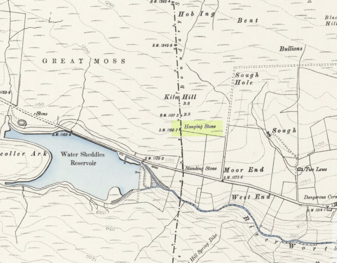
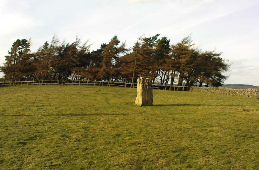
Pretty easy to find. Go along the Oakworth-Wycoller road, between Keighley and Colne, high up on the moors. When you get to the Water Sheddles Reservoir right by the roadside (y’ can’t miss it), stop! On the other side of the road walk onto the moor, heading for the walling a coupla hundred yards to your east (right). Where the corner edge of the walling ends, your standing stone is right in front of you! If for some reason you can’t see it, wander about – though beware the very boggy ground all round here.
Archaeology & History
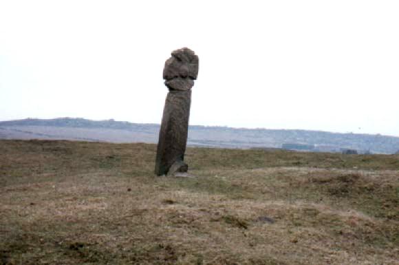
This seven-foot tall monolith, leaning to one side thanks to the regularly water-logged peat beneath its feet, stands on the Yorkshire-Lancashire. It is locally known as the Hanging Stone and the Standing Stone, but the name ‘Water Sheddles’ is a bittova puzzle. The place-names authority, A.H. Smith (1961) thinks it may derive from the middle-english word, shadel, being a ‘parting of the waters’ – which is pretty good in terms of its position in the landscape and the boggy situation around it. But ‘sheddle’ was also a well-used local dialect word, though it had several meanings and it’s difficult to say whether any of them would apply to this old stone. Invariably relating to pedlars, swindling or dodgy dealings, it was also used to mean a singer, or someone who rang bells, or a schedule, aswell as to shuffle when walking. Perhaps one or more of these meanings tells of events that might have secretly have been done here by local people, but no records say as such — so for the time being I’ll stick with Mr Smith’s interpretation of the word! Up until the year 1618 it was known simply as just a ‘standing stone’, when it seems that the words “Hanging Stone or Water Sheddles Cross” were thereafter carved on its west-face, as the photo below shows.
Cross carved on top of the stoneThe old stone, with its names carved for all to see
Whether or not this stone is prehistoric has been open to conjecture from various quarter over the years. Is it not just an old boundary stone, erected in early medieval times? Or perhaps a primitive christian relic? Certainly the stone was referred to as “le Waterschedles crosse”, as well as “crucem”, in an early record describing the boundaries of the parish of Whalley, dating from around the 15th century. This has led some historians to think that the monolith we see today is simply a primitive cross. However, sticking crosses on moortops or along old boundaries tended to be a policy which the Church adopted as a means to ‘convert’ or christianize the more ancient heathen sites. It seems probable in this case that an old wooden cross represented the ‘crucem‘ which the monks described in the early Whalley parish records.
Site marked on 1892 map
This monolith likely predates any christian relic that might once have stood nearby; although the carving of a ‘cross’ on the head of the stone may have supplemented the loss of the earlier wooden one. But it seems likely that this carved ‘cross’ was done at a later date than the description of the ‘crucem‘ in the parish records — probably a couple of centuries later, when a boundary dispute was opened, in 1614, about a query on the precise whereabouts of the Yorkshire-Lancashire boundary. After several years, as John Thornhill (1989) wrote,
“the matter was resolved on the grounds that the vast Lancastrian parish of Whalley had claimed territorial jurisdiction as far east as the Hanging Stone, thus the county boundary was fixed on the Watersheddles Cross.”
Water Sheddles stone looking SW
Certainly the stone hasn’t changed in the last hundred years, as we can tell from a description of it by Henry Taylor (1906), who said:
“The remains consist of a rough block of stone, leaning at an angle of about forty-five degrees against a projecting rock. The top end has been shaped into the form of an octagon, on the face of which a raised cross is to be seen. The stone is about six feet long and two feet wide, tapering to eleven inches square at the upper end, and appears once to have stood upright. Some local authorities have cut on it the words, ‘Hanging Stone or Waterscheddles Cross.'”
So is it an authentic prehistoric standing stone? Tis hard to say for certain I’m afraid. It seems probable – but perhaps no more probable than the smaller Great Moss Standing Stone found just a couple of hundred yards away in the heather to the west, on the Lancashire side of the boundary. Tis a lovely bitta moorland though, with a host of lost folktales and forgotten archaeologies…
The best way to get here it is to head from the Cow and Calf Hotel up the hillside to where the great rock is sticking out (the Pancake Stone). From here, head straight onto the moor toward the Idol Stone — close to the Idol Rock which you can see 400 yards south in front of you. From here, follow the footpath up the hill before you and keep on the path towards Lanshaw Lass. About 100 yards on, turn straight west into the heather and keep your eye towards the south. About 250 yards on, about 100 yards away from the Green Crag Top cup-marked boulder, you’ll see it!
Archaeology & History
One of very few solitary standing stones on Ilkley Moor, and one which I relocated after The Old Stones of Elmet (2001) had gone to press — which was a great pity. Nearly four feet tall, this is a good chunky monolith which stands close to being on line with the summer solstice alignment from the nearby Twelve Apostles stone circle. (I was gonna call it the Summer Stone, but thought better of it!)
There’s another recumbent stone, more than five feet tall when erected, 200 yards northwest of here. (This is also very close to being in line with with our chunky monolith, plus the Twelve Apostles. Anyone out there with a GPS who can check if this possible alignment is the last remnant of a summer solstice stone row? It probably isn’t, but it’d be good to find out.) On the same moorland level, heading back down, when the heather’s burnt back you’ll find a number of prehistoric tombs along the edge of the ridge. These don’t appear to be in the archaeological registers.
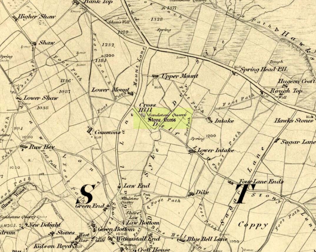
A half-mile south of the superb Brimham Rocks complex, take the straight road south until you hit the second farmhouse (and accompanying caravans). Go up the public footpath past Highfield Farm and just check with the landowner’s permission to wander his land if you want to see the stone. They’re OK about it if you ask. The lady there is very amiable and will tell you what’s what, giving directions right to it, telling us it was off the footpath in the middle of one of his fields.
Archaeology & History
Archaeology texts are, once more, silent about this stone (and other monuments in the region), making you wonder just what the hell some of them are paid for! The stone appears to have given its name to the land upon which it stands which, as the locals tell, “has always been known as standing stone hill.” And no wonder — it’s a bloody decent standing stone! On its northern face we find well-eroded lines running down the stone, similar to the weathering found on the Devil’s Arrows a few miles to the east.
Standing Stone Hill stoneLooking south
Although just over 6-feet tall, this is a solid bulky old fella. But the spot he presently occupies isn’t his original standing place. He was found knocked over and lying on the ground in the middle of the 20th century, slightly out of position. But he was thankfully stood back upright by the local land-owners sometime in the 1960s, where he’s been stood ever since. It must have been one helluva job! And making it more difficult was the intriguing geological nature of the Earth right beneath this field. As the lady who now own the land told us,
“When the fields were tilled we found that all of them were easy to turn over, except the one with the stone in it! There’s virtually no soil of any depth to write home about,” she said. “It stands on only a few inches of soil and then you hit solid rock right underneath it. All the other fields are OK – but this one’s the odd one out.”
And before the fields were farmed, just over a hundred years ago, all this land was covered in moorland heather. Then the land was enclosed, the Earth’s heathland stripped out of existence and turned over to agriculture. But thankfully the standing stone was left here. It makes you wonder what else was destroyed when the moorlands were industrialised…
The stone does get a brief mention in Boughey & Vickerman’s (2003) Prehistoric Rock Art of the West Riding, where they mention there being “three possible cups in (a) line on one side” of the standing stone, but these are little more than Nature’s handiwork and nowt else. There are a couple of other cup-and-rings nearby which are the real thing – but the ‘cups’ on this stone aint man-made.
From Keighley town centre, head north towards Cliffe Castle, but turn left beforehand and along Hollins Lane. Go past Hollins Hall for a few hundred yards and then through the gate on your left, then straight up the steep hill to the small woodland at the top. On the OS-map it’s shown as ‘Great Snowden.’ You’re here!
Archaeology & History
A standing stone found recently by Lindsay Lockwood to the west of Keighley, albeit on supposedly private—ahem!—land (a number of old locals tell you, quite rightly, to ignore this selfishness; but be careful of the land-owners here, who can be quite miserable). Tis less than four-feet tall but with a very noticeable female genital carving on its top western face. This carving however, is perhaps 200 years old at the very most. It’s in a quite beautiful setting aswell…
The Yoni or Cunt Stone, UtleyBuddhist scholar Steve Hart fondling the stone
What may be the remains of an old hut circle, or an old drained-out pond (a big difference, I know!), can be found about 100 yards northwest, and one – possibly two – ‘cairns’ can also be found in the scattered trees immediately to the northeast. An old ‘druid’s bowl’ (natural cup-marking into which rain-water collects) can also be seen on an adjacent earthfast boulder. Some folk might wanna allege a bullaun, but it’d be pushing it a bit I think. More recent walling and what appears to be stonework from more recent centuries (medieval) appears evident close by. Whilst below the hill we have the recently discovered Dragon Stone cup-and-ring carving just a few hundred yards away.
The setting is not unlike the beautiful little standing stone of Tirai on the slopes of Glen Lochay, where amidst the recently deserted village the short squat standing stone is found. You get the same sorta feeling of more recent going-on with this site aswell.
The carved ‘cunt’ gives an even more intriguing thought as to what the stone was used for, around Beltane perhaps, by folk like misself and other straightforward doods!
I wasn’t sure exactly what to call the stone after Lindsay had found it. However, due to the carved minge near the top, it seemed right to give the stone a name relative to the carving — and as we have a Devil’s Cunt in the Netherlands, I opted to call it something similar.* Although ‘cunt’ is an old European word for ladies’ lovely parts, the word ‘Yoni’ is an eastern title, which has become very acceptable in Western parlance. In recent years there has emerged a distinct aversion to using our own, old word for female genitals (indicating how detached people have become from even their own roots).
* of the name ‘cunt stone’: the word cunt itself, as explored eloquently in the fine study by Peter Fryer, Mrs Grundy: Studies in English Prudery (Corgi: London 1965), was the acceptable term for ladies’ genitals in the days when this carving was evidently done, so thought it a most applicable title.


")
")