From Pitlochry town centre, walk down the A924 high street as if you’re going to the Blair Atholl Distillery, but just before it take the right-turn and go over the river, and just keeping walking along this road for a third-of-a-mile (0.5km) until your reach a small small on your left that swerves up the hill (there’s a little signpost here saying Cluny Path to Strathtay). Go up and across the main road, then just keeping walking up the dirt-track, which becomes a footpath, and heads further uphill into and through the woodland. Make a bittova daydream from the walk up here, making sure to keep to the path closest to the burn (stream) on your left. Eventually when it levels out, you’re very close. Just keep on the same track and, where it meets up with another, bear left and about 100 yards along, on a small rise in the trees on your right, you’ll see these old stones peeking out. Keep your wits about you!
Archaeology & History
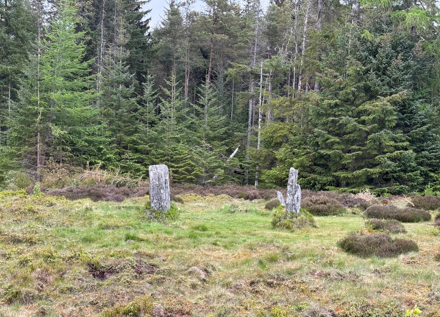
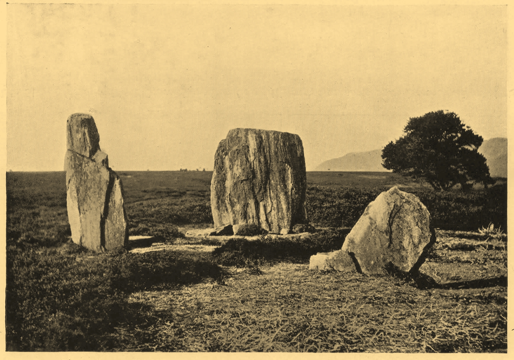
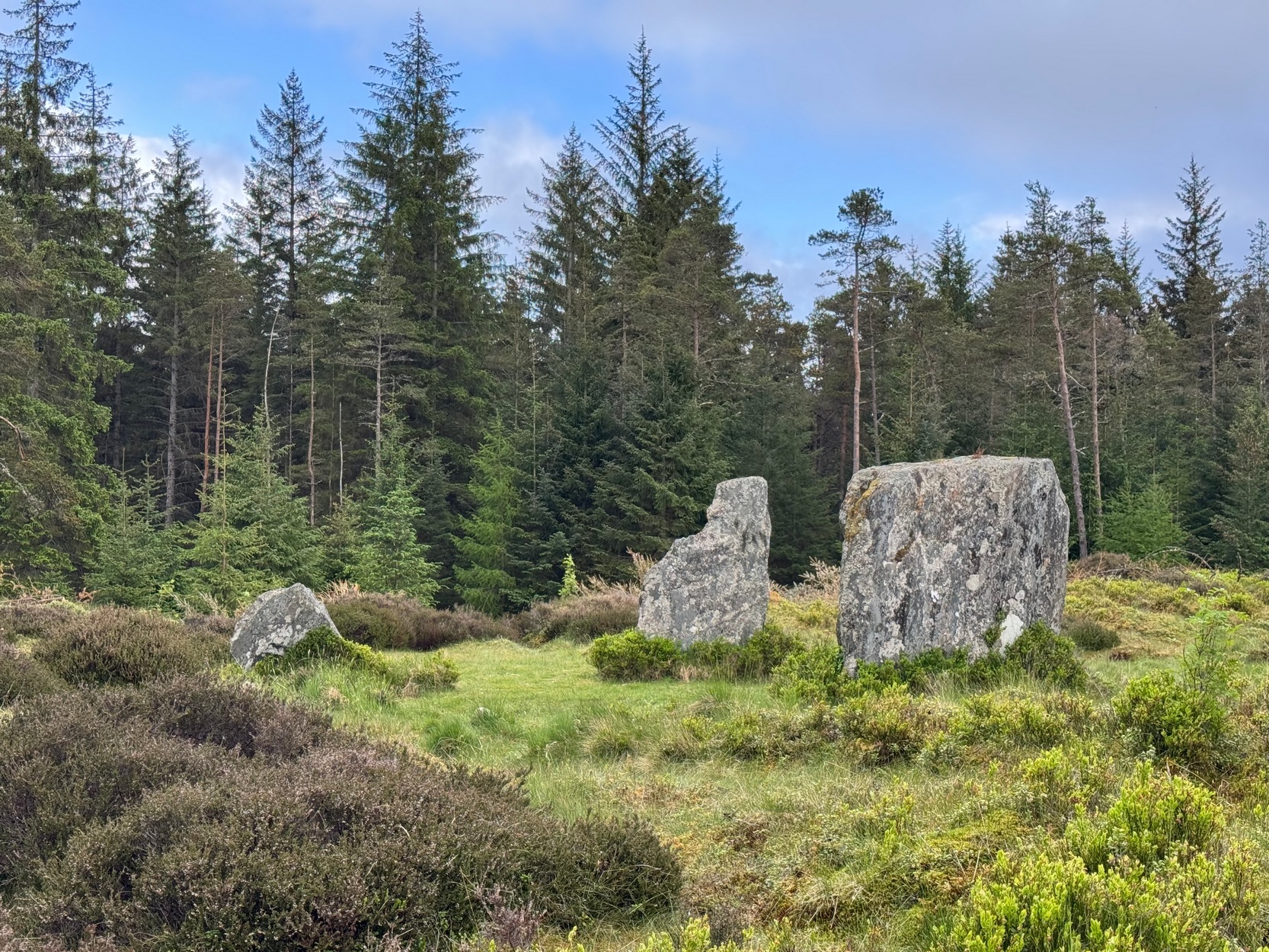
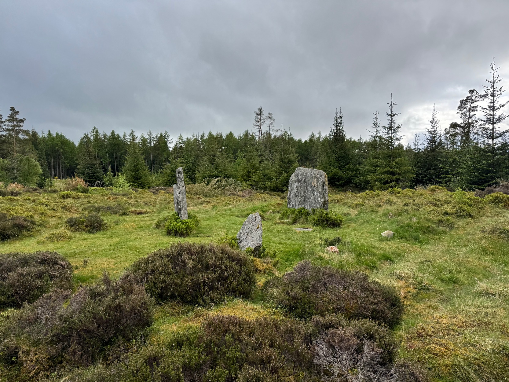
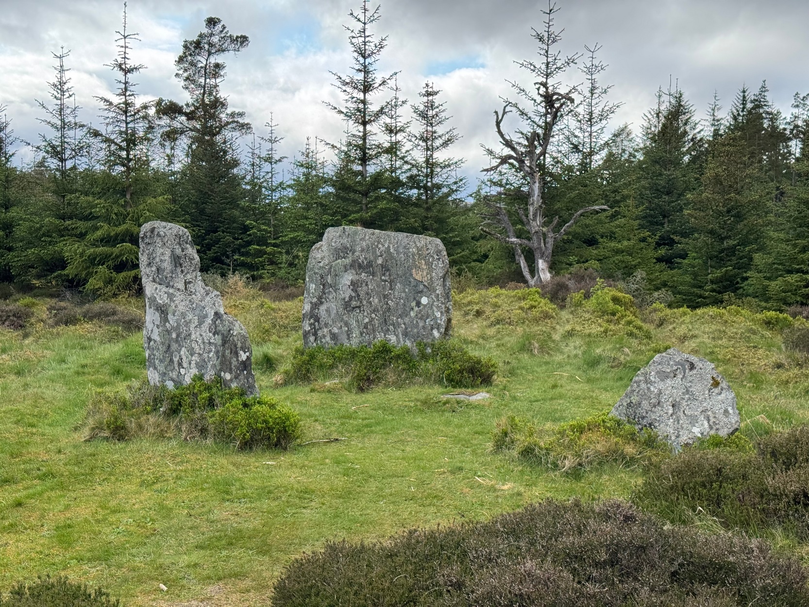
Clachan an Diridh looking E
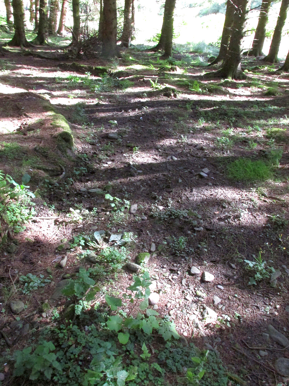
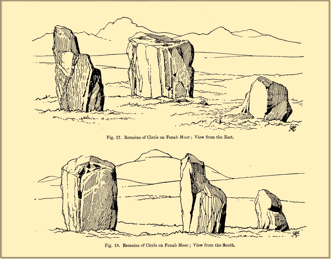
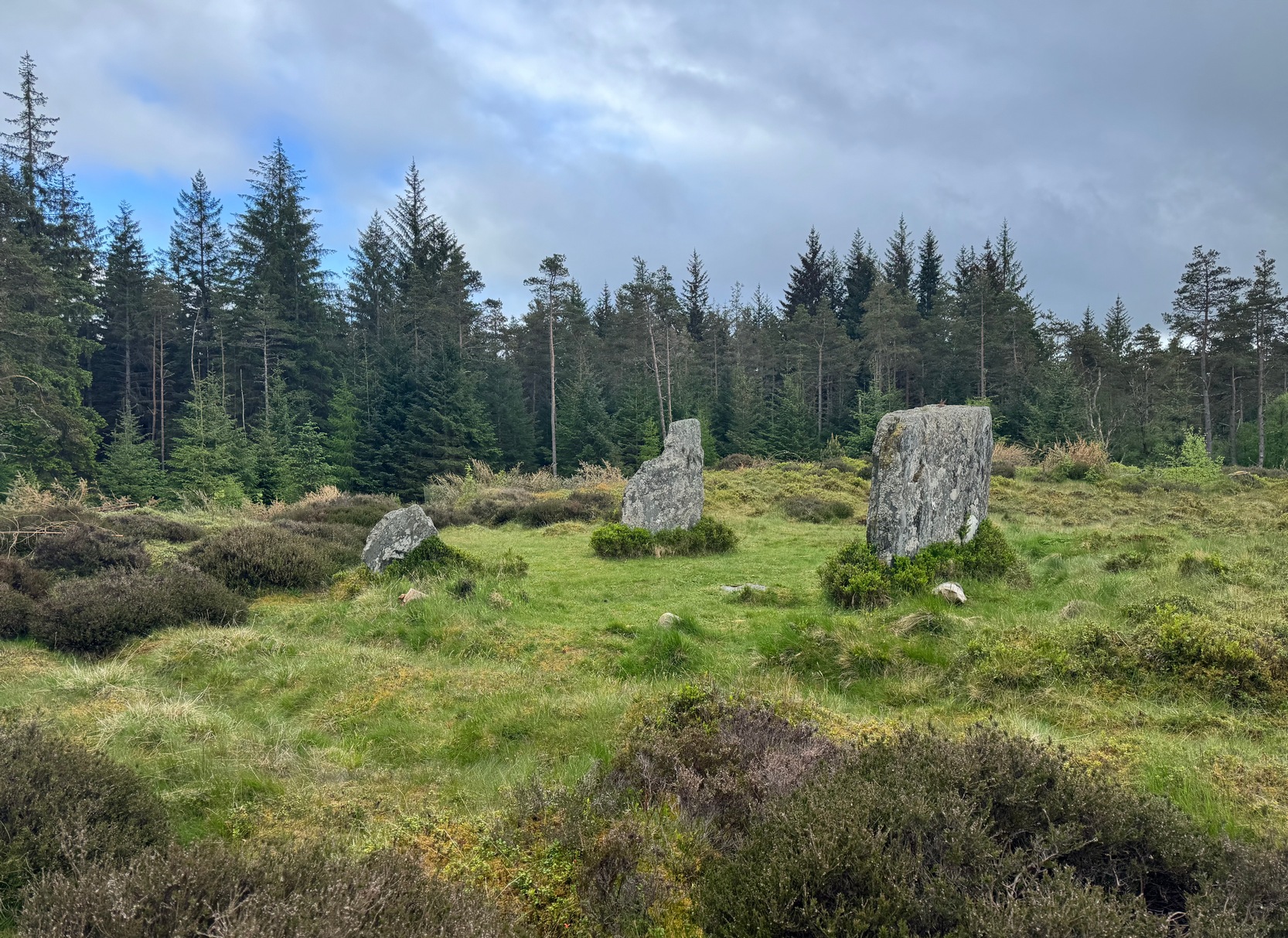
Sat high up on open moorlands with views all round… is what this site used to look like. Sadly, the forestry commission have almost completely enclosed this prehistoric site, making any view of the surrounding landscape all but impossible. I’m not the first and won’t be the last person to be pissed-off by such thoughtlessness. Alexander Thom made mention of it too. After making an initial assessment of the astronomical alignments at these stones in 1967, “when we returned to measure the horizon we found that trees had been planted round the stones and so we failed.” (Thom 1990) Not good.
On my first visit here, as I entered this “stone circle” my first impression was that it wasn’t a circle at all, but the remnants of a megalithic stone row! Thom thought the same. It’s the slender thin stature of the stones that do it to you: they almost cut the air and point the enquiring nose dead straight along the same angle that all the stones have been deliberately aligned to. I assume they’ve had a similar effect on other people over the years.
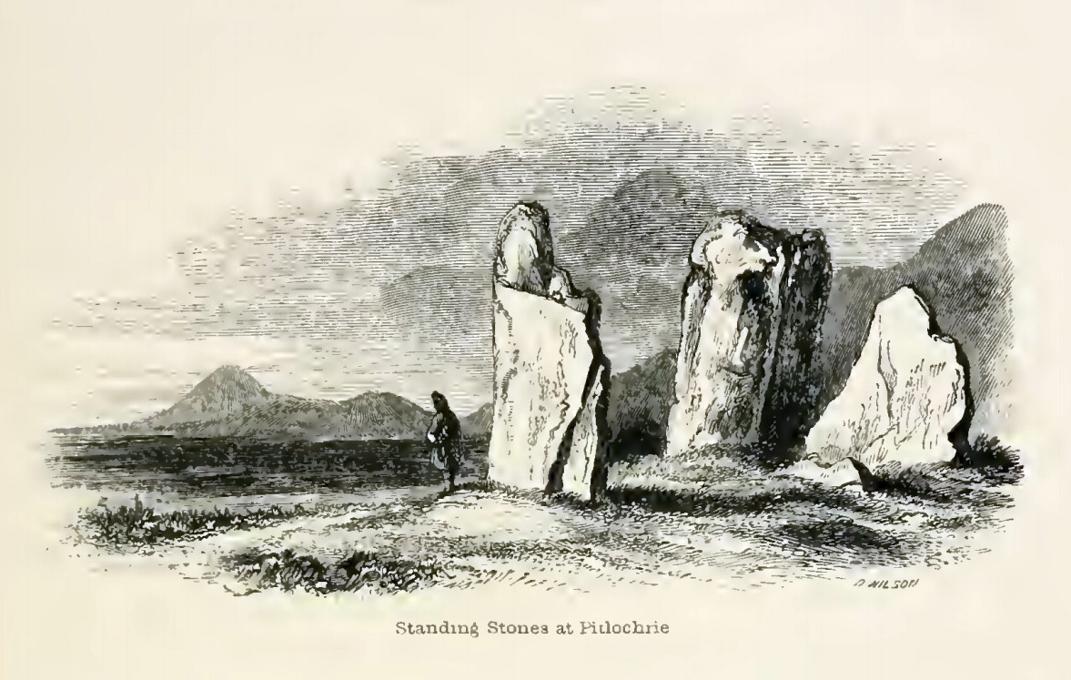
The Clachan an Diridh, or the Stones on the Ascent, were first mentioned in Dan Wilson’s (1851) major survey and who was so impressed by the view from here and its setting in the landscape that he compared its visage to Stonehenge. Were it not for the short-sightedness of the Forestry Commission destroying the view, most would no doubt agree with Wilson’s sentiments. From these olde stones, he told:
“One of the great level Highland moors stretches away beneath the eye, like a dark waveless lake, contrasting with the distant heights, among which Ben Lawers rears its pyramidal summit to an elevation of upwards of 4000 feet above the level of the sea. Amid this wild Highland landscape the huge standing stones, grey with the moss of ages, produce a singularly grand and imposing effect; and from the idea of lofty height which the distant mountains suggest, they convey a stronger impression of gigantic proportions than is produced even by the first sight of the giant monoliths of Salisbury Plain.”
Thom’s initial moonset alignmentThom’s 1980 ground-plan with marker stone
The giant figure of Ben Lawers, if we could see it today, would rise to the southwest 20 miles (32km) from here; and the great pyramidal fairy mountain of Schiehallion would be equinox west, 13 miles (21km) away. Yet curiously when Alexander Thom surveyed the outlying hills, he didn’t think either of these mountains had any worth, astronomically speaking that is. Yet Lawers in particular would be the largest point on the southwestern horizon, rising in the distance, way beyond the wide rolling U-shaped glen of Strathtay to where the landscape changes into more rugged dynamic uplands. And the importance of Lawers as a place in prehistory is shown by the mass of petroglyphs across its slopes—particularly the side you could see from Clachan an Diridh.
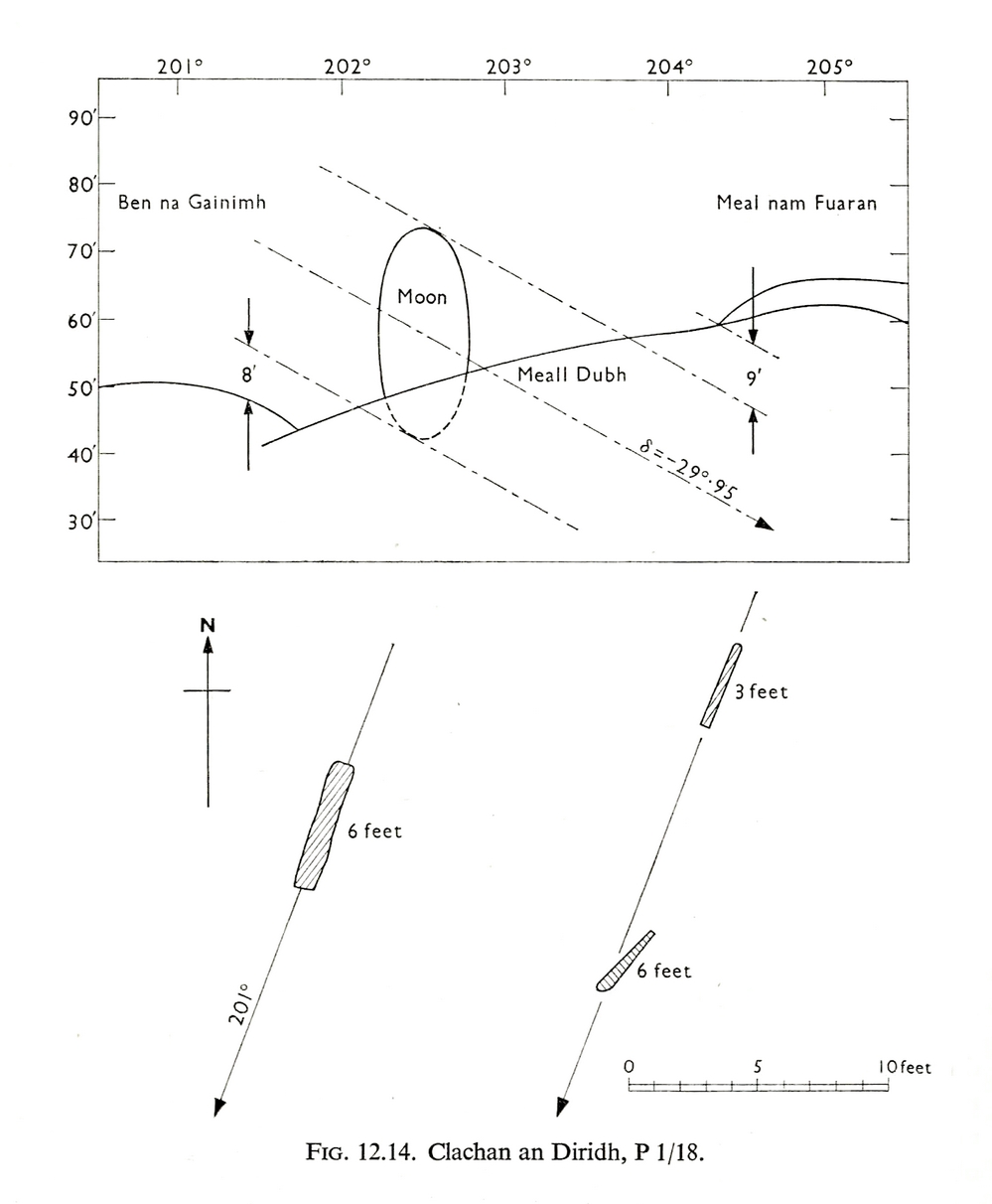
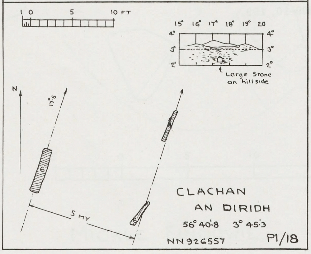
Instead, Thom (1967) looked much further to the southwest—south-southwest in fact—where he initially thought that there was an alignment to the major southern moonset ten miles away above the rugged hill of Meall Dubh, framed on either side by the mountain peaks of Meall nam Fuaran and Beinn na Gainimh. Aubrey Burl (1988) told how Thom later discounted this alignment and instead turned his attention a full 180° where a large stone on the hillside to the north-northeast caught his theodolytic eye. This marked an alignment towards the peak of Ben Vrackie:
“There is little doubt,” he wrote, “that this is a lunar site showing perhaps…at the major standstill. Could one side of the southern 6ft high stone possibly have indicated the setting point of the Moon at minor standstill?” (Thom 1990)
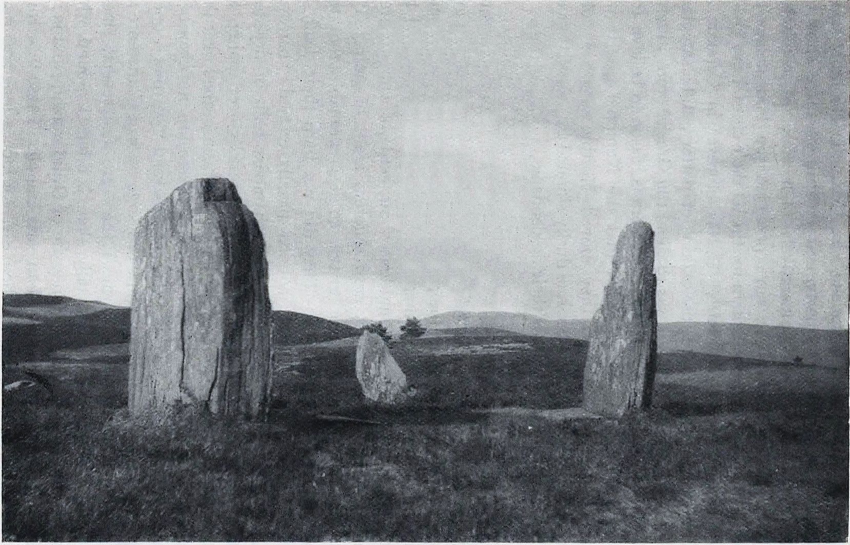
Clachan an Diridh in 1851Clachan an Diridh, c.1920
Thom looked at these stones and the landscape with the mind of an astronomer, whereas I’m more in preference of the aborigine who sees the feel of the landscape to discern relationships and meanings. Sometimes, of course, the sky and the landscape come together and that universal mythic union of heaven and Earth finds importance at a site. I have little doubt that such a mythos was once known here, on the moorland plateau, under the clear stars with the darkness reaching to speak with Lawers and other bones of landscape in the solid darkness of mountain silhouettes and fading horizons. Many a sleep at this site would have touched minds with Wonder…
Anyway, all that aside…
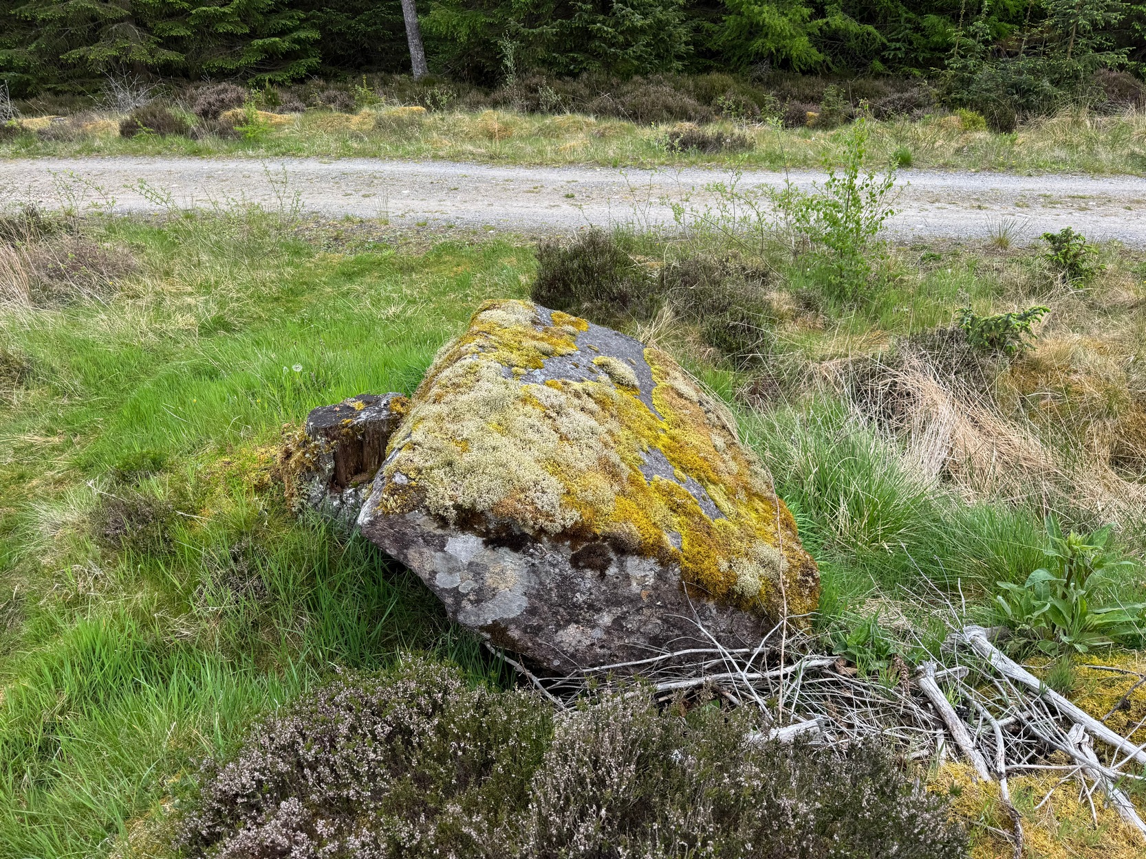
Large fallen stoneSite on the 1899 OS-map
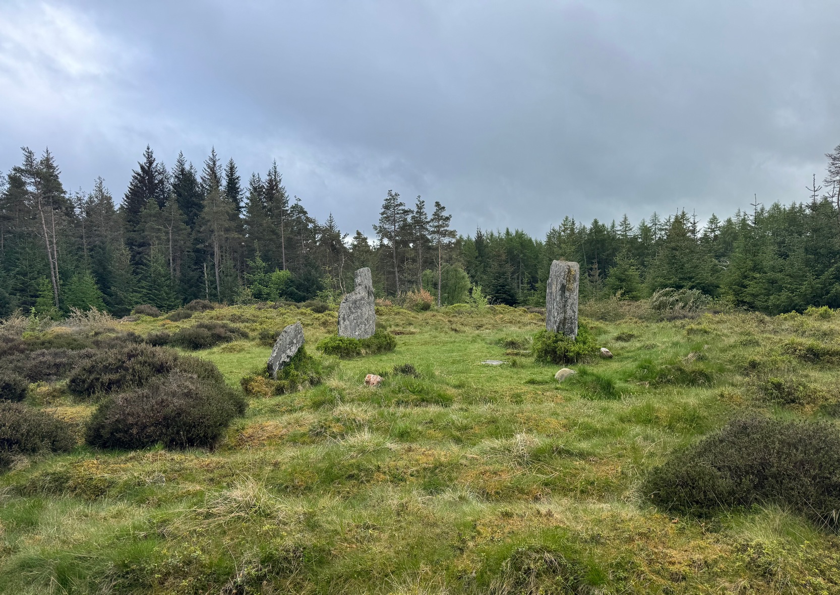
These megaliths have been classified as one of Aubrey Burl’s “four posters”, i.e., a rough square of four megalithic uprights, in spite of there only being three standing stones here. Even when Dan Wilson (1851) wrote about the place there were just three of them. However, down the slope from the stones, just off the recent trackside, there’s a decent contender for the fourth stone lying on its side in the undergrowth, half-covered in moss. It’s certainly fallen or rolled down the slope and its size and shape suggest that it may once have stood upright. Have a thoughtful fondle of it while you’re here.
The ‘circle’ was highlighted on the 1899 OS-map and, a few years later, was visited and surveyed by the great Fred Coles (1908) and like Dan Wilson before him, told the view from here to be “very grand.” He continued:
Coles 1906 planColes’ views, from S & E
“In local parlance this group is known as the Four Stones. This must be a fairly old name handed down through some generations; because, for at least fifty-seven years past, only three Standing Stones have remained in situ. These three Stones are arranged as shown in the plan…in a group forming in its now imperfect condition a triangle which, measured from the centres of the Stones, has its SE side 11 feet 6 inches long; its SW side 12 feet 3 inches ; and its north side 16 feet 3 inches. Fragments of the demolished fourth Stone lie about the ground; but there is no clear indication of its original position. The South Stone, A, is 3 feet 7 inches in breadth, 5 feet 10 inches in height, and from 12 to 4 inches in thickness. The West Stone, B, 6 feet in height, measures 5 feet at the back, and 4 feet 10 inches at the front, and is 18 inches in thickness. The East Stone, C, at its outer angle is 3 feet 3 inches above ground, and leans inward. All the blocks are of quartziferous gritty sandstone, the East Stone being particularly rough and fissured. A large fragment lying near it seems to be a portion of it. The Stones are set upon a fairly true Circle with a diameter of 15 feet 4 inches. One feature quickly arrests notice: this is, that the broader faces of these Stones are not set even approximately upon and in line with the circumference, but nearly parallel with each other—an arrangement quite unlike the setting of Stones in the many other Circles hitherto surveyed.”
When Burl (1988) added this site to his Four Posters survey he merely echoed Coles’ early description, adding that, in his view, the standing stones that we see today were probably, originally, “set out on the circumference of a circle 20ft (6.1m) in diameter.”
I think it’s likely that there would have been more prehistoric sites in the vicinity, but a notable oddity is the almost complete absence of other recorded sites anywhere nearby. Of course, if there was anything, those thoughtful Forestry Commission heads would have destroyed it. We are left, simply, with the old but reliable notes of Messrs Dixon (1923) and Mitchell (1925) who told that, in their days, other remains did exist nearby in the form of ancient cairns and hut circles—‘Pictish’ according to tradition. If we’re lucky, some damaged parts of them might still be found at the edges, a short distance to the north west…
Folklore
In Hugh MacMillan’s (1901) gorgeous literary sojourn along Strathtay, he strayed somewhat from his otherwise historical notices by telling that here,
“on the highest part of the moorland…is a group of ‘clachan iobairt’, or stones of worship, where the Druids of old performed their mysterious rites, going round the circle of standing stones from east to west with the sun, or the ‘car deasal’, the lucky side, when they wished to invoke a blessing upon their friends, and going round the circle in the opposite direction, from west to east, the ‘car tuathsel’, or unlucky side, when they wished to pronounce a curse upon their foes.”
Whether this was what Hugh Mitchell (1923) meant when he referred to the traditions surrounding Clachan an Dirirdh we don’t know, but he echoed MacMillan’s account (though made no reference of his words), also adding that it was a site that “was visited on the first of May” or Beltane by some local people….
References:
Burl, Aubrey, Four Posters: Bronze Age Stone Circles of Western Europe, BAR 195: Oxford 1988.
Burl, Aubrey, A Guide to the Stone Circles of Britain, Ireland and Brittany, New Haven & London 1995.
Burl, Aubrey, The Stone Circles of Britain, Ireland and Brittany, Yale University Press 2000.
Dixon, John H., Pitlochry, Past and Present, L. Mackay: Pitlochry 1925.
Kennedy, James, Folklore and Reminiscences of Strathtay and Grandtully, Munro Press: Perth 1927.
Liddell, Colin, Pitlochry – Heritage of a Highland District, PKDL: Perth 1993.
MacMillan, Hugh, The Highland Tay: From its Source to Dunkeld, H. Virtue: London 1901.
Mitchell, Hugh, Pitlochry District: Its Topography, Archaeology and History, L. Mackay: Pitlochry 1923.
Omand, Donald (ed.), The Perthshire Book, Birlinn: Edinburgh 1999.
Stevenson, J., “Prehistory,” in Omand’s The Perthshire Book, Edinburgh 1999.
Thom, Alexander, Megalithic Sites in Britain, Oxford University Press 1967.
Thom, Alexander, Megalithic Lunar Observatories, Oxford University Press 1971.
Thom, A., Thom, A.S. & Burl, H.A.W., Megalithic Rings, BAR: Oxford 1980.
Thom, A., Thom, A.S. & Burl, Aubrey, Stone Rows and Standing Stones – volume 2, BAR: Oxford 1990.
Wilson, Daniel, The Archaeology and Prehistoric Annals of Scotland, Sutherland & Knox: Edinburgh 1851.
Acknowledgements: Huge thanks for use of the Ordnance Survey map in this site profile, reproduced with the kind permission of the National Library of Scotland.
On the west-side of the River Spey from Fochabers, follow the road-signs taking you south on the B9015, and near Inchberry is a tiny road on your right (careful not to miss it). Go along here to the end of the long straight road and turn right, down the track. When you reach the trees, bear left along the track to St Mary’s, Orton, marked “Private road”. 🙂 Parking is limited to one car only but very quiet.
Archaeology & History
St Mary’s Well, Inchberry (21st Century Pict)
Set in a stunning location next to the river Spey with a magnificent view of Ben Aigan to the south, St Mary’s Holy Well and Pool is easy to find behind the Chapel / Mausoleum wall, dedicated to the Duff Family. There is a small stone basin in the wall which may have been the Chapel font. At the time of my visit the weather has been dry and sunny for some time. The pool below the iron grate has been recently cleared of leaves before my visit, with no standing water but the stones on the bottom of the pool looked damp. And with the cemetery above and behind the wall, perhaps it was for the better.
It was clear and running, said J.F.S. Gordon (1880) at the end of the 1700s, but when he came to write about it the flow “has ceased for many years, and is now only a feeble, filthy, stagnant Driblet for the use of cattle.” Pilgrimages were made here on the first Sunday in May, and water collected from the site was kept for a year, in return for an offering (usually a stone or other inanimate object) that enabled the magickal spirit of the well to enact cures.
Folklore
A site described by Watson (1868) as being “long held in superstitious reverence”, the well was said to cure whooping cough, eye problems and joint conditions. It had thoroughly un-christian shennanigans practised here by local folk, much to the consternation of the usual culprits! Visited extensively by people from far and wide, Mr & Mrs Morris (1981) told,
(21st Century Pict)
“The visits displeased the Kirk and there were various summonses to the Session for “going supersticiously to a Vell at Speyside” and of persons who “kneillit about the chappell and drank the water.” The minister at Ruthven reported that a large number had gone to the chapel well “thrie Saturdays before Lambas and thrie efter called the six silie Saturdayes, and that the conventions wer on the night or before day in the morning.” And “quhairas zierlie about Lambnes, the ignorantes repaired to ane wel at this kirk, called Our Ladie Wel, superstitiouslie, and kneeled about the said kirk, it is reportit that the evil is removed.” This may be the well associated with the White Witch, Dame Aliset, who cured a fairy child with simples and the well water.”
References:
Bord, Janet, Holy Wells in Britain – A Guide, HOAP: Wymeswold 2008.
Watson, J.& W., Morayshire Described, Russell & Watson: Elgin 1868.
Acknowledgements:Huge thanks for use of the Ordnance Survey map in this site profile, reproduced with the kind permission of the National Library of Scotland.
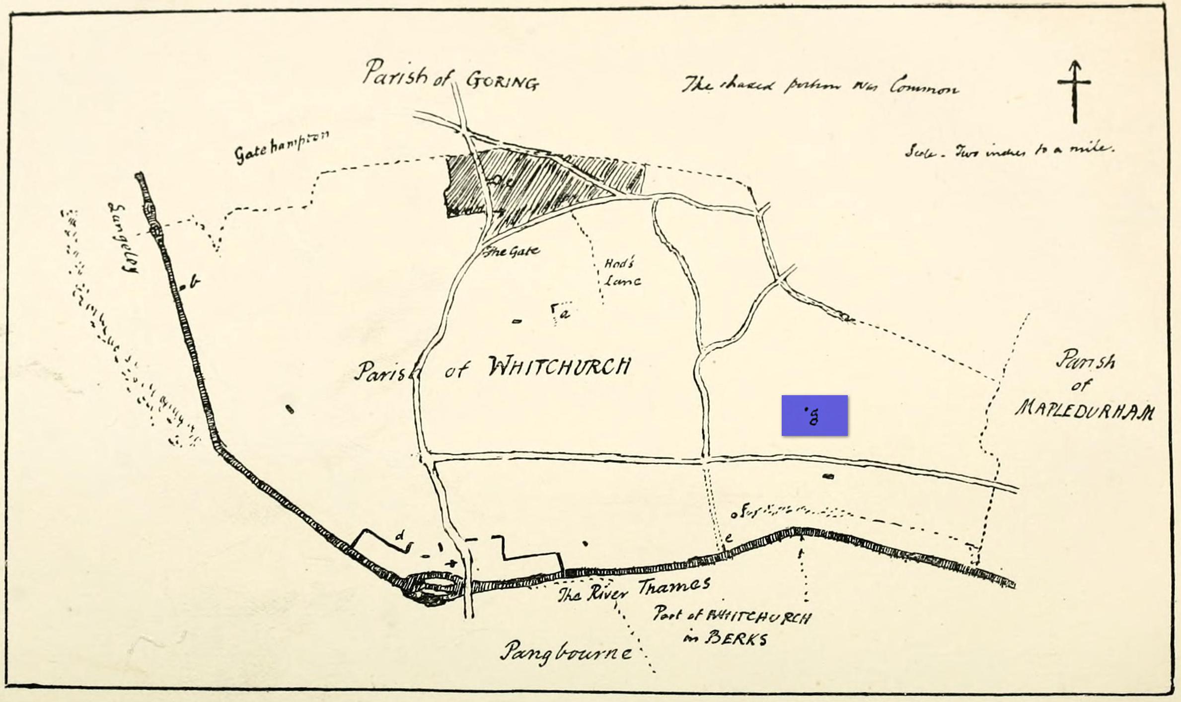
Maypole (destroyed): OS Grid Reference – SU 655 781
Archaeology & History
“g” marks the spot!
Very little is known about the history surrounding Whitchurch’s maypole that once stood more than a mile east of the village, somewhere in the woods immediately south of the present-day cannabis-growing Hempem Organics. (damn those hippies!) Mentioned in the Enclosure Acts of 1806 and 1813 as the “May Pole Ground”, the monument was mentioned in the Rev. John Slatter’s (1895) local history work and its approximate location was shown on a hand-drawn map he did of the area, in the grounds north of Hardwick House. He told us that it stood on “an elevated site” and conjectured that it might once have been a place of druidical worship!
“In the centre of the Hardwick property is a plot of ground called the Maypole Piece…. It is an open space, with a tree standing alone, where we may suppose the maypole formerly stood. There is a memorandum made by the last Mrs. Lybbe (nee Isabella Twysden) to this effect:
1713: A maypole set up on ye hill in ye straight way to Collinsend.”
In the event that you manage to discover anything else about the history of this maypole, let us know on our Facebook group.
References:
Gelling, Margaret, The Place-Names of Oxfordshire – volume 1, Cambridge University Press 1953.
Slattter, John, Notes on the History of the Parish of Whitchurch, Elliot Stock: London 1895.
Maypole (destroyed): OS Grid reference – SD 5161 9212
Archaeology & History
Long since gone, it’s existence was recorded by, amongst others, the Kendal historian Cornelius Nicholson. (1861) He described it in relation to one of the town crosses, that was removed due to it being “an obstruction in the street.” The maypole too, he said,
“was another incumbrance, but indispensable, according to the custom of our forefathers. It stood in Kirkland, opposite the house of the late Thomas Reveley, Esq., and was suffered to remain till within eighty years ago. In the time of our good Queen Katherine, who may fairly be supposed to have partaken of the amusements, countenanced by her royal consort, the original festivity of maying and morris-dancing would be here celebrated, by the annual ceremony of “maying” when, immediately after sunrise, on the 1st of May, processions, entering the town at various inlets, streamed through the streets, with music of horns and flutes; boys with their May-gads (willow-wands twined with cowslips), and girls with their “brats” full of flowers — young and old alike joining in merry laughter, and song, and the customary chorus, “We have brought the summer home.” When the above-named ceremonies became less fashionable, the May Pole was made the rendezvous of all the milkmaids in the neighbourhood, who came and paraded round it on Easter Mondays. On other occasions of rejoicing, afterwards, such for instance, as terminating an apprenticeship, and the like, it became customary for young men to go and dance around it.”
The author then told that this annual village ceremony was still being performed at the beginning of the 19th century, “in the assemblage of young people in the Vicar’s Fields, on Easter Tuesday. After spending the afternoon there, they returned in procession through the streets, threading grandy needles.”
References:
Nicholson, Cornelius, The Annals of Kendal, Whitaker & Co.: London 1861.
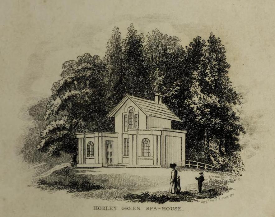
The historian William Addison (1951), in his history on the subject, told how “the spas began as holy wells”; and although no direct accounts are left of early dedications here, the remnants of Mayday traditions tell us there were more archaic goings-on before the waters were taken by the aristocrats. Once it had been designated as a spa, the waters were covered and a typical Spa House constructed over them. From hereon, for more than a century, the waters were accessible only to those with money who wished their ailments to be treated.
Between the end of the 18th to the end of the 19th century, the Horley Green Spa was a very prominent ingredient in the history of Calderdale. A chalybeate or iron-bearing spring, its waters were directed into a large underground cistern covered by metal. Thomas Garnett (1790) was the first to write about it, telling us:
“The Horley Green water is quite pellucid—sparkles when poured out of one glass into another—and has a sharp, aluminous, styptic taste, not unlike ink. The taste is not unpleasant when the water is taken from the springhead and drank immediately.”
He went on to espouse the waters to be good in healing bone and rheumatic diseases, giving many first-hand accounts from people in Yorkshire and beyond who used the waters here with apparent success, including one case of curing diabetes! Its reputation was later reinforced in a book by William Alexander (1840), who told us how,
“I unhesitatingly affirm that the Horley Green Spa possesses a very strong claim to be regarded as a powerful tonic and chalybeate.”
By the time those words were written, it had already gained a considerable reputation and many were those who’d received treatment.
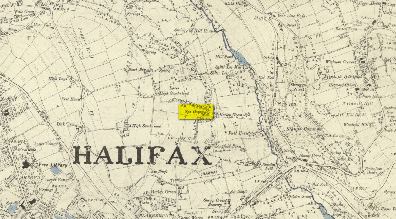
Spa House on 1894 map
A years after Alexander, the roving doctor A.B. Granville (1841) visited Horley Green—who described it as “a renowned steel-water Spa”. But at the same time he reported how its popularity had started to decline. But, via one Mr West, he did leave us with a greater chemical analysis of the Horley Green waters in an attempt, once more, to certify and prove its curative properties. Their results found the waters to possess, in varying quantities, lime, magnesia, silica, iron oxide, sulphur and silica—all of which further attributed the science of its medicinal actions. A number of case histories of the people cured here can be found in the works of Granville, Garnett and Alexander.
The well-house that stood here eventually fell into disuse. When it was eventually restored as someone’s home in the the late 20th century, the disused spring was found beneath the foundations, filled with stones.
Folklore
Horley Green’s spa well came about as a result of local people visiting the site around Beltane, probably for centuries before the aristocrats and early pharmacists took their hand to the place. But once the spa became renowned, people could only gather here “on the first Sundays in the month of May,” with Sunday being that legendary ‘day of the lord’ crap, to which the people would abide to save them from prosecution. It is obvious though that it had been used as a place of magick thanks to the snippets of lore which have found their way into local history books. We read how, at 6am, people gathered here, to such an extent that the roads were completely crowded. Those who arrived first were given bags of nuts: an archaic traditional motif found at many pre-christian wells in Britain. Occultists and ritual magickians amongst you will note the time when folk frequented the well, at 6am: the time when many nature-spirits are invoked for full effects. We find this time echoed in the ritual gatherings at Lady or St. Anne’s Well in Morley, just a few miles to the east.
References:
Addison, William, English Spas, Batsford: London 1951.
Alderson, Frederick, The Inland Resorts and Spas of Britain, David & Charles: Newton Abbot 1973.
Alexander, William, “On the Mineral Springs of the Parish of Halifax,” in Proceedings Geological & Polytechnic Society, West Riding, Yorkshire, volume 1, Edward Baines: Leeds 1849.
Crabtree, John, Concise History of the Parish and Vicarage of Halifax, Hartley & Walker: Halifax 1836.
Granville, A.B., Spas of England, Henry Colburn: London 1841.
Hembry, Phyllis, The English Spa 1560-1815, Athlone Press: London 1990.
Short, Thomas, The Natural, Experimental and Medicinal History of the Mineral Waters of Derbyshire, Lincolnshire and Yorkshire, privately printed: London 1724.
Short, Thomas, A General Treatise on Various Cold Mineral Waters in England, privately printed: London 1765.
As with traditions found all over the world, rivers and lakes had spirits, gods and rituals attached to them. Despite us believing that no such things ever occurred in Britain and the rest of the so-called ‘civilized’ world, such things were once common. One of the annual rites performed at the Hebridean river at Barbhas (Barvas)—and described by Alexander Fraser (1878)—is just one such example:
“The natives of Barvas had a peculiar custom on the first day of May, of sending a man across the river at (the) dawn of day to prevent any females from crossing it first, as that would hinder the salmon from ascending the river all the year through.” (Fraser 1878)
The importance of the salmon, both as an important food source and equally as a ‘sacred animal’, is known in myths and legends throughout the British Isles. To the legendary hero-figure Finn, it played a part of him gaining supernatural wisdom, and this quality is integral to the fish itself who ate the hazelnuts of knowledge and gained such power. In this same short piece of folklore, the time of year when the ritual should be enacted on the River Barvas is Beltane, which is renowned as the prime period in the annual cycle/calendar relating to fertility. This element relates to maintaining the fecundity of the river and the salmon where, in this case, men crossing the waters symbolically fertilizes them to ensure the annual return of the fish. It would be interesting to know when this custom finally died out.
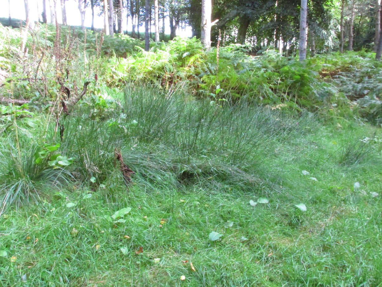
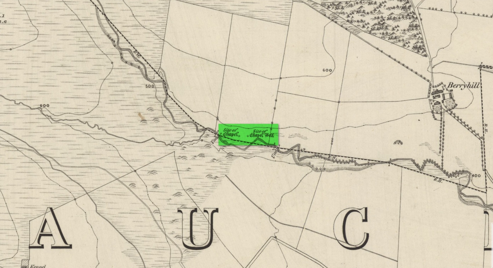
I accessed the site by parking up at Little Tullybelton, walking up the hill and crossing into the field on the left just north of the wood, then walking due west (crossing barbed wire fences) until dropping down into the valley of the Ordie Burn and following the track into the wood, then, noting where the burn crosses south of the old stone wall. The site of the well is marked by some tussocks of cotton grass. Don’t confuse with a patch of nettles and docks 2-300 hundred yards east where you enter the wood.
Archaeology & History
This well was destroyed about 170 years ago and the site of it is quite hard to find as the land has been turned over to forestry. It was near a chapel and burial ground that were also destroyed by the farmer of the time. The old wall formed part of the boundary of the detached portion or enclave of the neighbouring parish of Methven.
The Reverend Thomas Nelson, Minister of the Parish of Auchtergaven, has this to say in the New Statistical Account of 1845:
‘Superstition formerly invested St Bryde’s, and Chapel Well, and perhaps some others, with a sacred character, and made then places of resort for pious purposes.
‘On the south march of Berryhill Farm, in the same lands of Tullybeagles, there is the site of.. a chapel, where there was a burying-place, where human bones have been recently dug up; and, till of late, the people in the neighbourhood used, on the first Sabbath of May, to drink out of the Holy Well there. This sacred place is on the banks of the Ordie.’
The OS Name Book has the following entry regarding the Well:
‘The site of a Holy Well which has been traditionally associated with the adjacent chapel. The water of this well is now carried by a covered drain into the adjacent stream, and the well filled in‘.
And this regarding the Chapel:
‘The site of an ancient chapel on the north bank of the Ordie Burn, the chapel was demolished and the graveyard rooted up some years ago by the present tenant of the farm, who has pointed out the site, the dedicatory name is not known‘.
Site shown on 1867 mapAncient track to chapel & well
I could find no evidence of the culvert which discharges the waters of the Well into the Burn. What does seem to have been missed is the survival of part of the ancient sunken roadway or pilgrim path to the site, which is still clearly visible. The fact that it was visited by locals on the first Sabbath in May would point to it having originally been a Beltane well, and therefore of pre-Christian origin.
References:
The New Statistical Account for Auchtergaven, Perthshire, 1845
From Kenmore village on the north-side of the river, over the bridge, take the small road on your right towards Dull. After a very short distance the road runs alongside the woodland for nearly 1½ miles until, on your left, you’ll reach Drummond Cottage. Across from here a dirt-track takes you into the trees. Barely 100 yards along, watch for the overgrown path that runs down the slope on your left. At the bottom a small stream has several feeds – one of which is surrounded by a ring of bright quartz stones.
Archaeology & History
Shown on the early Ordnance Survey maps as An Tobar (meaing simply “a well”), this somewhat nondescript title betrays a much more colourful folk history, albeit dissolved by those common culprits of Church and disrespectful incomers (which shows little sign of diminishing).
Lara by the Well
Close-up of quartz surround
In the field immediately south, back up the slope above the well and through the trees, was once an ancient church whose existence has all but vanished. Hereby was held an ancient fair known as Feill nam Bann Naohm, or the Fair of the Holy Women, named after a group of nuns whose lived here, who William Gillies (1938) and others proclaim were the legendary Nine Maidens, whose dedications at wells, trees and other sites scatter Scotland. But the fair was ended in 1575 and moved to Kenmore; then, several years later in 1579, the church also moved onto Eilean nam Ban Naomh (NN 7664 4536) on Loch Tay.
The old well however, after being left by the descendants of the Holy Women or Nine Maidens, continued to be frequented by local people. Gillies (1938) wrote:
“The Holy Well of Inchadney is situated at the foot of the terrace, about five hundred yards to the north of the churchyard… Up to the middle of last century the well used to be visited by great numbers of people on the morning of Bealtuinn, the first day of May.”
In Ruth & Frank Morris’ survey (1981) they told how the site had become much overgrown and,
“The well was cleaned out in 1914 and among articles found was a stone 21 inches by 16 inches, with a rude St Andrew’s cross scratched on it, a George III farthing among other copper coins, a rudely made stone cup 2½ inches high and 7 inches in diameter, three metal buttons, a glass bead and six pins.”
No such offerings seemed in evidence when we visited a few weeks ago; but we were told that people are still seen visiting the well.
Looking into the pure waters
A small stone-laid footpath runs towards the adjacent burn from the circular well, which is almost completely surrounded by large quartz rocks. In the well itself was a small fish, showing how clean the waters are—or as would be deemed in times of olde: a ‘guardian’ of the waters.
We must also make note of the fact that, just two fields away to the north, according to the antiquarian Fred Coles (1910), a stone circle was once in evidence. This old well sat neatly between the sites of megalithic ring and church.
Folklore
In the field in front of the well, Hilary Wheather (1982) told that there once lived a legendary water bull, but she lamented on his passing. With the coming of the modern-folks and their unnatural ways,
“and having great timber lorries rumbling past your home every day is no fun for a peace-loving waterbull living in Poll Tairbh, the Bull’s Pool opposite the Holy Well. Gone are the days when he was the revered Spirit of the Meadow, passed with trembling and fear by all the young maids of the Parish lest he should jump out and carry them off to his watery lair. Half the calves of the area were sired by him and it was always easily seen which cow had the attentions of the Great Waterbull. Her calf was always the biggest and the best. But he hasn’t been seen by his pool for many a year…”
The waters are cited by Geoff Holder (2006) to be good for toothache.
On the east side of Warrengate Road, approached from Welham Green via Dixons Hill Road, or from Brookmans Park via Bradmore Lane.
Archaeology & History
1920 photo of the Public House. The Maypole is thought to have been in the grounds to the rear
The exact position of the pole is not marked on the 1896 25″ OS map, as it is probable that it had been removed by the middle of the nineteenth century (like the majority of the permanent Hertfordshire maypoles), but local belief in the 1950s and 60s was that it had been in the garden of the Old Maypole (originally known as ‘The Maypole’) public house, which adjoined the smithy in Warrengate Road, Water End. The public house is stated to have been built around 1520, with later additions, but is now a private house.
The population of Water End and nearby Welham Green was predominantly employed in agriculture, domestic service and straw plaiting, but the area’s proximity to London probably speeded the demise of the ancient traditions like maypole dancing .
The 1896 OS-map showing the grounds to the rear of the pub
Doris Jones-Baker writes: “The old Hertfordshire maypoles, on May Day decorated with ribbons and a bunch of spring flowers at the top, were described as being ‘as high as the mast of a vessel of a hundred tons, painted often in a diagonal or spiral pattern from bottom to top in yellow and black, or often in vertical stripes of red, white and blue’”
Interestingly, the rear of the public house garden adjoins the Swallow Holes, a geological feature where the intermittent flowing waters of the Mimmshall Brook disappear into the chalk in as many as 15 sink holes. Hertfordshire has an ancient tradition of ‘woe-waters’ related to the local geology, where the flowing or not of a stream or spring was seen to herald ‘sorrow to come’. From personal memory the Mimmshall Brook is normally a dry stream bed which can in winter suddenly turn into a raging torrent, flooding the land behind The Old Maypole. Any tradition of it having been a woe-water has though been lost. But it is just possible that long ago the coming of May Day was also seen to herald the end of flooding of the Mimmshall Brook and may explain the siting of the pole.
The last year that people danced is not recorded, but the local maypole tradition continued; this writer remembers ribbon dancing as a very small child to a fiddle accompaniment around a maypole erected at the nearby, but long demolished Waterend C.E. Primary School, which closed in 1960.
Folklore
As well as Maypole dancing, Hertfordshire had a rich tradition of May day ritual and song, which despite the county’s proximity to London, survived long enough for some of it to be recorded for posterity. While there does not seem to be any ritual recorded for North Mymms, the following was recorded at nearby Hatfield. “On may morning, dressed in white and holding bunches of Hawthorn or, in late seasons, blackthorn blossoms the children sang door to door a local version of the May song, which began:
‘A bunch of May I bring unto you
And at your door I stand,
Come pull out your purse,
You’ll be none the worse
And give the poor Mayers some money….’”
References:
North Mymms Local History Society, North MymmsPictures From The Past, Welham Green, 2002
Jones-Baker, Doris, The Folklore of Hertfordshire, B.T.Batsford, London, 1977
Kingsford, Peter, North Mymms People in Victorian Times, Brookmans Park, Hertfordshire, Privately Published, 1986
Maypole (destroyed): OS Grid Reference – SE 2068 2672
Archaeology & History
As in countless villages and towns across the British Isles, Gomersal also once had its maypole near or at the village centre. We don’t know when the first maypole was erected in the village and many local sites were openly destroyed by rampant christian puritans and similar idiots. It stood not far from the Moor Lane Well and was described by the regional historian H.A. Cadman (1930), who told:
“The Maypole was at the top of Moor Lane and one can imagine the welkin echoing to the very old song:
‘Come lasses and lads take leave of your dads
And away to the maypole hie.
For every fair has a sweetheart there
And the fiddlers standing by.
For Willy shall dance with Jane
And Johnny has got his Joan.
To trip it, trip it, trip it, trip it,
Trip it up and down.’
Yet as with maypoles up and down the land, testosterone-fuelled Springtime fall-outs happened. Mr Cadman told:
“Very often May Day gatherings ended up with fights. Great jealousy always existed between the inhabitants of Great Gomersal, Little Gomersal and Spen. There is a tradition which has been handed down that the last Maypole in this district stood on Liversedge Green. This Maypole was demolished in a fight by the Gomersalians and there is a similar tradition about the Maypole on Cleckheaton Green, so as Mr Frank Peel says, “It is evident that ancient inhabitants of Gomersal were more pugnacious than their neighbours.” I have no evidence when the Gomersal Maypole ceased to exist, but there is abundant evidence to prove that there was one in Gomersal, the proof being that the vane is now in Batley Museum. It is in the form of a fish.”
If anyone has any further information on this important relic, or its history, please let us know.
References:
Cadman, H. Ashwell, Gomersal, Past and Present, Hunters Armley: Leeds 1930.
“One of the great level Highland moors stretches away beneath the eye, like a dark waveless lake, contrasting with the distant heights, among which Ben Lawers rears its pyramidal summit to an elevation of upwards of 4000 feet above the level of the sea. Amid this wild Highland landscape the huge standing stones, grey with the moss of ages, produce a singularly grand and imposing effect; and from the idea of lofty height which the distant mountains suggest, they convey a stronger impression of gigantic proportions than is produced even by the first sight of the giant monoliths of Salisbury Plain.”

 I think it’s likely that there would have been more prehistoric sites in the vicinity, but a notable oddity is the almost complete absence of other recorded sites anywhere nearby. Of course, if there was anything, those thoughtful Forestry Commission heads would have destroyed it. We are left, simply, with the old but reliable notes of Messrs Dixon (1923) and Mitchell (1925) who told that, in their days, other remains did exist nearby in the form of ancient cairns and hut circles—‘Pictish’ according to tradition. If we’re lucky, some damaged parts of them might still be found at the edges, a short distance to the north west…
“on the highest part of the moorland…is a group of ‘clachan iobairt’, or stones of worship, where the Druids of old performed their mysterious rites, going round the circle of standing stones from east to west with the sun, or the ‘car deasal’, the lucky side, when they wished to invoke a blessing upon their friends, and going round the circle in the opposite direction, from west to east, the ‘car tuathsel’, or unlucky side, when they wished to pronounce a curse upon their foes.”