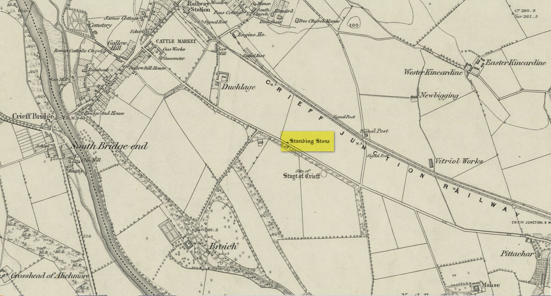
Standing Stone (destroyed): OS Grid Reference – NN 8655 2079
Archaeology & History
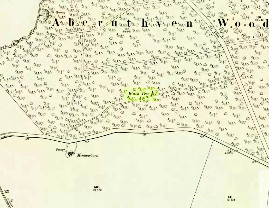
Site on the 1866 map
There is seemingly no trace left of this once impressive tall, slender standing stone that had lived for thousands of years on the south-side of Crieff. It was destroyed by some retard in the middle of the 20th century (anyone know their name?). Highlighted on the 1866 Ordnance Survey map of the area, it was visited and described by the late great Fred Coles (1911) when it still stood at the side of the road. He told that it was,
“In shape a narrow rhomboid at the base, this Stone rises to an acute angle at a height of 6 feet. Its longer axis is E.S.E. 52° by W.N.W. 52°, and in basal girth it measures 8 feet 11 inches.”
Coles’ 1911 sketch
Some 200 yards to the south-east there used to be the curiously-named Stayt of Crieff burial mound which had been used as a court hill for many centuries. This outlying standing stone may have been the “witness” on which oaths were sworn before the court. Sadly the history of the Stayt of Crieff mound is also somewhat sparse and it too has, appallingly, been destroyed. The destruction of these antiquities and their ancient traditions is nothing short of a fucking disgrace.
Finlayson, Andrew, The Stones of Strathearn, One Tree Island: Comrie 2010.
Acknowledgements:Huge thanks for use of the Ordnance Survey map in this site profile, reproduced with the kind permission of the National Library of Scotland.
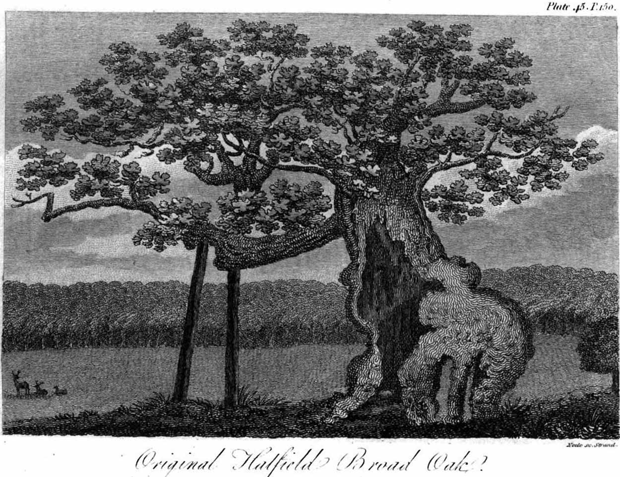
Erroneously ascribed by the reverend Winsland (1952) as being the ‘Doodle Oak’, the ancient and giant tree called the Broad Oak was, as records show, always known by this name, but was subsequently replaced by another after its demise. It was this second tree that became known as the Doodle Oak. Winsland described it as “an immense and famous oak tree”, under whose “spreading branches in olden days the Lord of the Manor probably held his court and dispensed justice.”
The tree was described as early as 1136 AD and was probably an early tribal meeting site, or moot spot. In Philip Morant’s (1763) work, he described it as,
“A tree of extraordinary bigness. There has been another since…called Doodle Oak.”
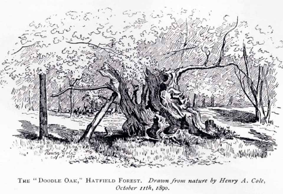
The old Oak in 1890
The Doodle Oak was thought to date from around 10-11th century and its predecessor may have been upwards of a thousand years old before this one took its place. In 1949, one patient botanist, Maynard Greville, investigated the Doodle Oak tree-rings and found it to be 850 years old. Other estimates suggest it was a hundred years older than that! Whichever was the correct one, a measurement of its trunk found it to be some 19 yards in circumference – one of the largest trees ever recorded in Britain!
Sketches of its dying body were thankfully made near the beginning and the end of the 19th century: one in Mr Vancouver’s (1807) Agriculture of Essex, and the other by Henry Cole of the Essex Naturalist journal.
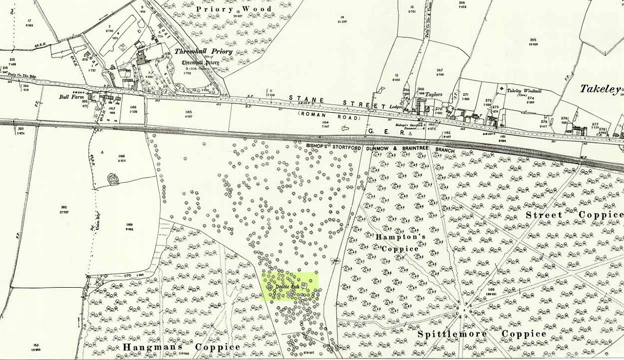
Doodle Oak on 1896 map
Some speculate that the Broad Oak of ancient times and the subsequent Doodle Oak were at very different places in the parish, but without hard evidence this idea is purely hypothetical. And whilst the name ‘broad’ oak is easily explained, the name ‘doodle’ is slightly more troublesome. However, a seemingly likely etymology is found in the Essex dialect word dool, which Edward Gepp (1920) told,
“seems to mean, (1) a landmark; (2) a path between plots in a common field.”
The former of the two would seem to be the most likely. This is echoed to a greater degree in Wright’s (1900) magnum opus, where he found the dialect word dool all over the southeast, meaning,
“a boundary mark in an unenclosed field.”
Giant trees on ancient boundaries, like the Broad Oak of earlier times, would seem to be the most probable reason for its name. Today, all that’s left of the site is a small plaque on a small tree-stump, telling us what once stood here…
Just off the A9 between Stirling and Perth is Aberuthven village. Down the Main Street and just south of the village, turn west along Mennieburn Road. A half-mile on, just past Ballielands farm, you reach the woods. Keep along the road for another half-mile, close to where the trees end and go through the gate where all the rocks are piled. Walk up to the tree-line 50 yards away and follow it along the line of the fence east, til it turns down the slope. Naathen – over the barbed fence here, close to the corner, about 10 yards in, is the tree in question…
Archaeology & History
Looking along the fallen trunk
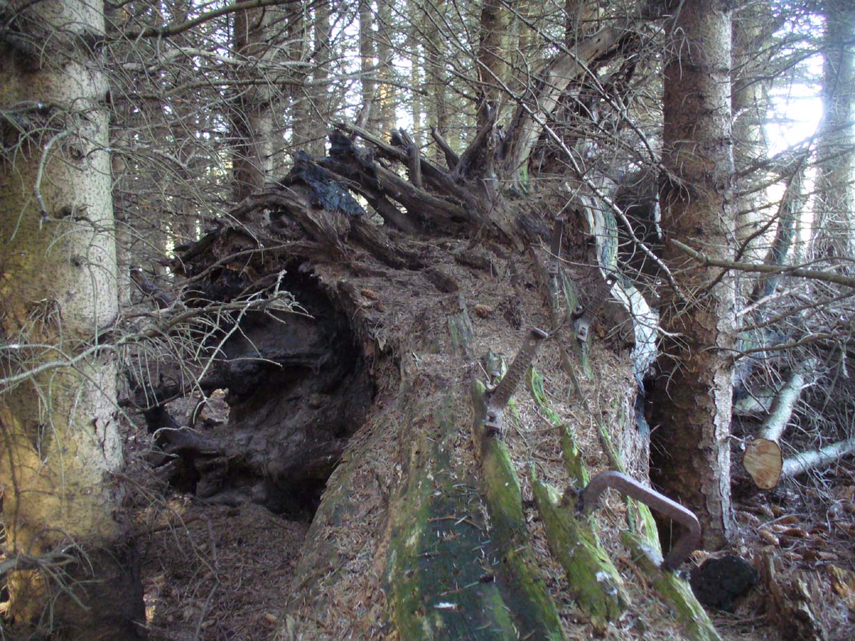
Laid down on the peaty earth, fallen perhaps fifty years ago or more, are the dying remains of this all-but forgotten Witch Tree. To those of you who may strive to locate it—amidst the dense eye-poking branches of the surrounding Pinus monoculture—the curious feature on this dying tree are a number of old iron steps or pegs, from just above the large upturned roots. About a dozen of them were hammered into the trunk some 100 years or more ago and, were it to stand upright again, reach perhaps 30 feet high or more. These iron pegs give the impression of them being used to help someone climb the tree when it was upright; but their position on the trunk and the small distance between some of them shows that this was not their intention. Their purpose on the tree is a puzzle to us (does anyone have any ideas?).
Embedded iron from the roots
Embedded iron 30-40ft along
The fallen trunk has broken into two main sections, each with iron pegs in them. The very top of the tree has almost completely been eaten back into the Earth. Unfortunately too, all the bark has completely rotted away and so identifying the species of the tree is difficult (though I’m sure there are some hardcore botanists out there who’d be able to enlighten us). The possibility that the early map-reference related to a Wych-elm (Ulmus glabra) cannot be discounted, although this would be most unusual for Ordnance officers to mistake such a tree species with a ‘witch’. Local dialect, of course, may have been a contributing factor; but in Wilson’s (1915) detailed analysis of the regional dialect of this very area, “wych elm” for witches does not occur. Added to this is the fact that the indigenous woodland that remains here is an almost glowing birchwood (Betula pendula) in which profusions of the shaman’s plant, Amanita muscaria, exceed. There were no wych elms hereby.
The tree was noted by the Ordnance Survey team in 1899 and was published on their maps two years later, but we know nothing more about it. Hence, we publish it here in the hope that someone might be able top throw some light on this historical site.
Folklore
Halfway along the fallen tree
We can find nothing specific to the tree; but all around the area there are a plethora of tales relating to witches (Hunter 1896; Reid 1899)—some with supposedly ‘factual’ written accounts (though much of them are make-believe projections of a very corrupt Church), whilst others are oral traditions with more realistic tendencies as they are rich in animistic content. One of them talks of the great mythical witch called Kate McNiven, generally of Monzie, nearly 8 miles northwest of here. She came to possess a magickal ring which ended up being handed to the owners of Aberuthven House, not far from the Witch Tree, as their associates had tried to save her from the crazies in the Church. This may have been one of the places where she and other witches met in bygone centuries, to avoid the psychiatric prying eyes of christendom.
Until the emergence of the Industrialists, trees possessed a truly fascinating and important history, integral to that of humans: not as ‘commodities’ in the modern depersonalized religion of Economics, but (amongst other things) as moot points—gathering places where tribal meetings, council meetings and courts were held. (Gomme 1880) The practice occurred all over the world and trees were understood as living creatures, sacred and an integral part of society. The Witch Tree of Aberuthven may have been just such a site—where the local farmers, peasants, wise women and village people held their traditional gatherings and rites. It is now all but gone…
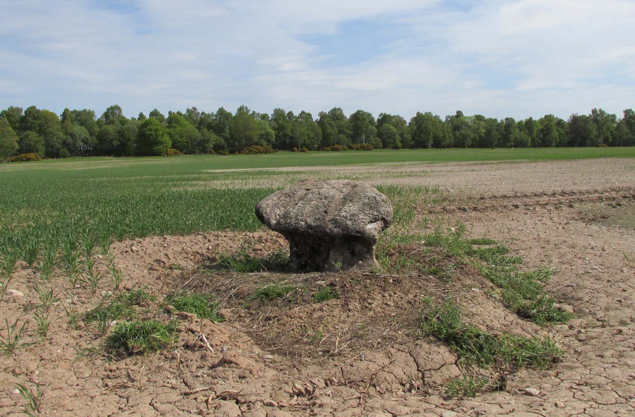
Going north-eastish from the city of Perth, take either the A93 or A94, turning west along the A93 a mile south of Guildtown, or east at Balbeggie on the A94, until you reach St. Martin’s hamlet and park up just below the church opposite the old cottages. Walk up the track below the cottages (not the one above them!) for ⅘-mile (1.35km) [past the ruined Cupar Stone Circle], and where the land has levelled out and in the huge flat field on your left, you’ll eventually reach a gate and see the odd-looking ‘rock’ about 250 yards away in the middle.
Archaeology & History
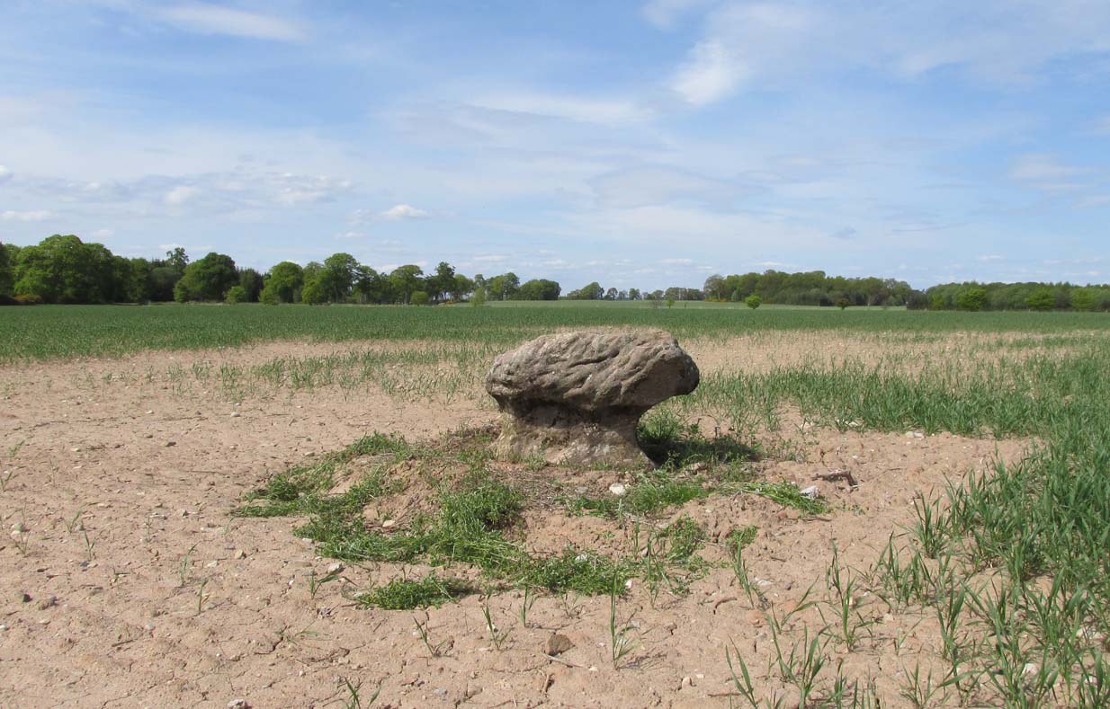
A fungal morel turned to stone
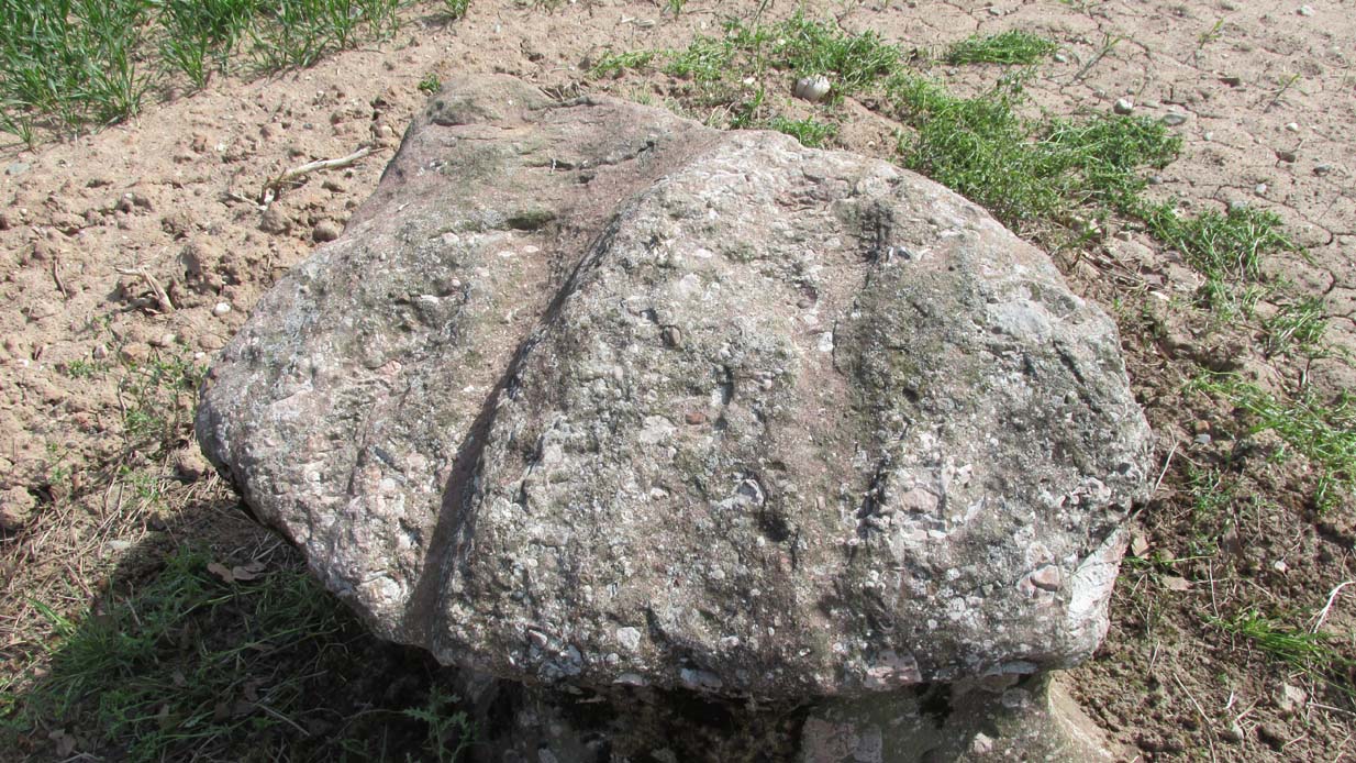
In a quiet and little-known parish that was once littered with about a dozen stone circles, there remains a most curious and fascinating stone which, in earlier days, was to be seen on the open moorlands at this spot. The area was then forested and then the agriculturalists came with their farming and destroyed the forests, leaving the old stone as it presently stands, isolated, above the hamlet of St. Martin’s to the south. Although it was described in the 19th century as being “four feet high”, it stands barely three feet tall, is very curiously-shaped—just like a morel mushroom from some angles—and in the middle of an extensive piece of flatland where the crops barely grow.
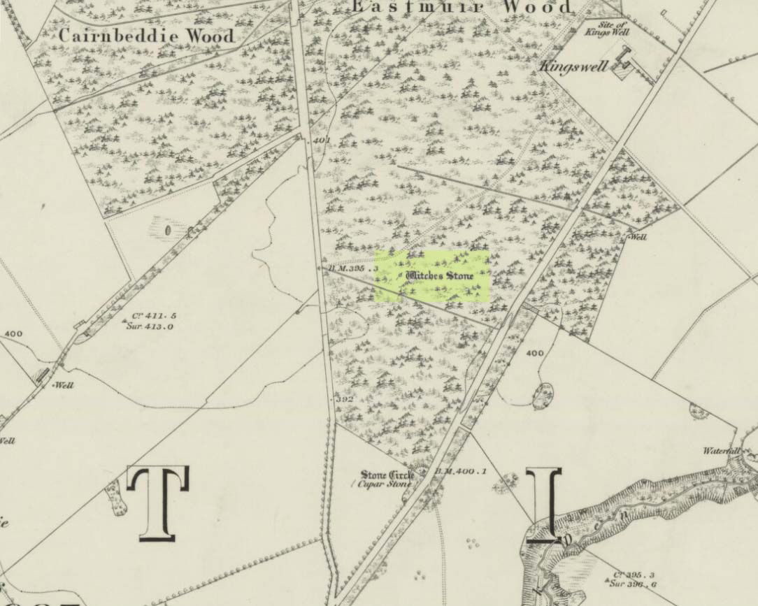
Witches Stone on 1866 map
Witches Stone, looking west
The stone was highlighted on the first OS-map of the parish in 1866, showing it in the woodland plantation of Eastmuir. It may have been some sort of northern outlier related to the now-destroyed stone circle of Cupar 400 yards south; and if this was the case, its position in the landscape relative to the circle would give the Witches Stone an airt (virtue ascribed to cardinal directions) in the cycle of the year that relates to darkness and death. (Perhaps oddly—perhaps not—the name of parish St. Martin’s relates to that dark period in the calendar, as St. Martin’s day in the old calendar was Samhain or Halloween: old New Year’s Day, when the spirits of the dead moved across both land and skies.)
It was erroneously described by the Canmore lads as being little more than “a glacial erratic”, but the stone here is quite earthfast; and their idea that “its peculiar shape has probably been caused by wind erosion”, is also somewhat dubious considering the shape of other monoliths and megalithic rings in the region. The stone has an appearance similar to some Bull Stones, where the animal was chained to rocks such as this and then baited by dogs, although I can find no such lore here. Indeed, the history and archaeology of the stone seems all but silent. Its folklore however, would have the Shakespearian romanciers amongst you flocking to the place…
Deep grooves atop of the stone
The top of the stone has some very distinct and deep-cut lines running across it at angles, and has the appearance of being cut into at some time in the dim and distant past. By whom, and for what reason, we cannot say.
Folklore
William Richie (1845) told us that in the 11th Century when Scotland was having to deal with the english disease of stealing land and spreading its violence, King MacBeth—whose castle stood within this parish at Cairnbeddie (NO 1498 3082)—took that advice of two witches, and that
“they met him one night at a place still called ‘the Witch Stane’ (where a remarkable stone still stands), about a mile from his old residence, and warned him to beware, ‘Till Birnam forest come to Dunsinane.’”
The 1860 Name Book told us that,
“The Moor where the witches met, which is in St. Martins Parish is yet pointed out by the country people, and there is a stone still preserved, which is called the Witches Stone.”
References:
Scott, Aleander, St. Martin’s and Cambusmichael, Perth 1911.
Richie, William, “St. Martins and Cambusmichael,” in New Statistical Account of Scotland – volume 10: Perthshire, William Blackwood: Edinburgh 1845.
Acknowledgements: Huge thanks to Prof Paul Hornby for showing me this site. Cheers matey!
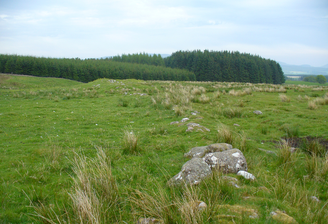
Along the A820 road between Dunblane and Doune, from the Dunblane-side, take the very first minor road on your right a few hundred yards after you’ve come off (or over) the A9 dual-carriageway. Go all the way to the very top of this long and winding road for several miles, until you reach the gate which prevents you going any further. Walk up the slope on your left (west) and you’ll see the large grassy mound a coupla hundred yards ahead of you. That’s it!
Archaeology & History
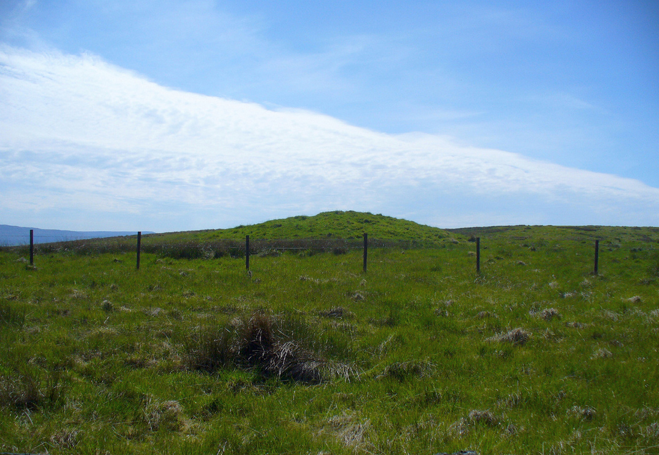
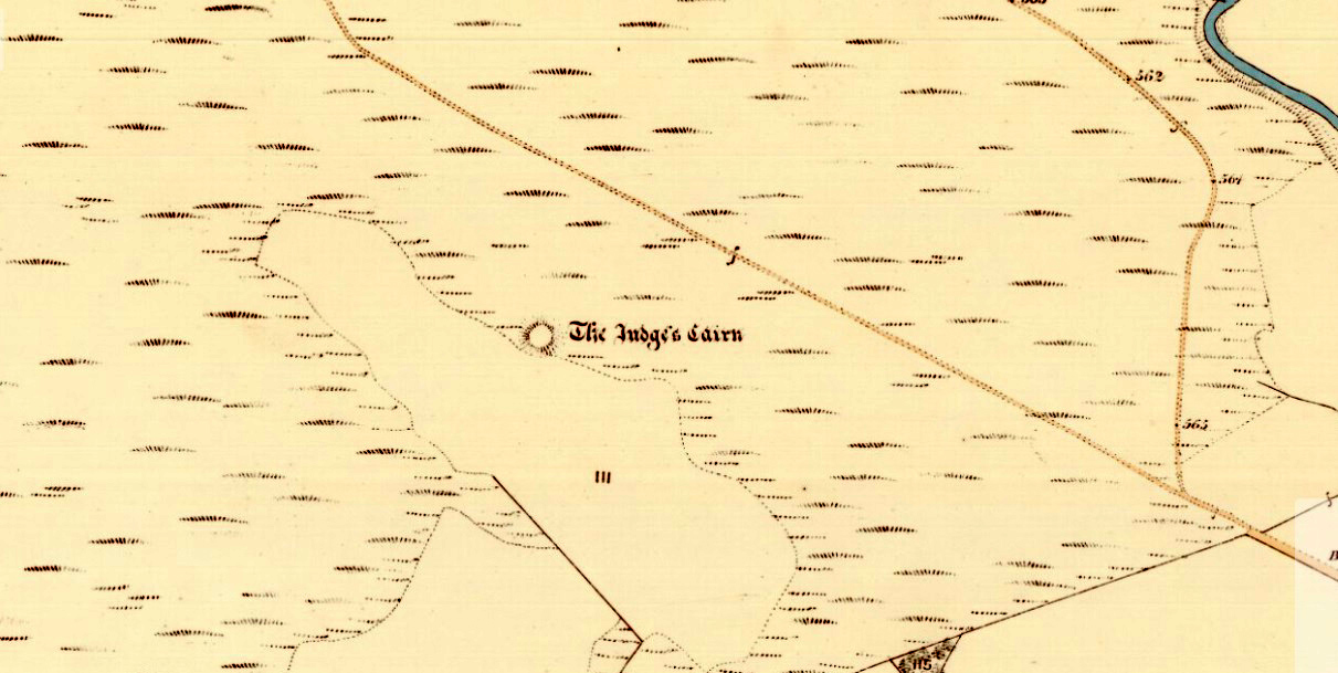
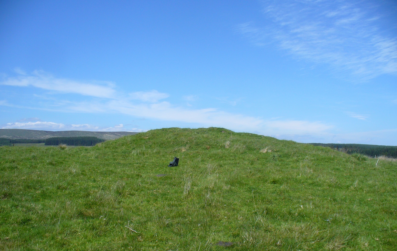
Highlighted on the first Ordnance Survey map of the area in 1862, this is a large rounded prehistoric cairn of some considerable size, whose position in the landscape allows for an impressive 360° view way into the distance in several directions—a deliberate ingredient, no doubt, when it came to building this probable tomb. I say “probable”, as there has never been a dig (not an ‘official’ one anyway) into the heart of this overgrown rocky mound.
Looking SE into the OchilsJudges Cairn on 1862 map
More than 60 feet in diameter at its greatest and 6 feet high, with a circumference of 67 yards (61m), the top of the mound has been disturbed and, clearly, has been dug into at some time in the distant past—but archaeohistorical accounts are silent on this matter. The first description of the Judge’s Cairn seems to have been in Peter Stewart’s (1839) notes on the local antiquities of Dunblane, where he described it most simply as:
“The Judges Cairn, yet undispersed, a circular heap of rough mountains stones covered with furze, on the farm of Bowie, barony of Kilbride.”
Along with the Ordnance Survey lads who came here in 1862, all subsequent visits gave rise to only short notes about the place. Odd, considering its size and distinct vantage point. And yet it remains hidden from view unless you come from the north, from whence that archetype of a fairy mound raises itself above Nature’s fair body into the eyes of any ambling wanderer…. A wonderful place to sit and dream for a while…
Folklore
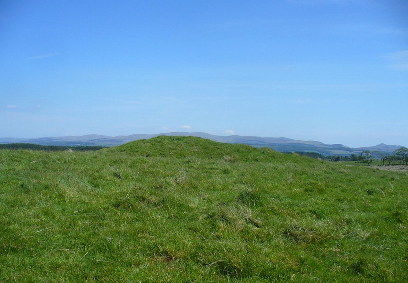
Judges Cairn, looking NE
We enquired with a local whose family had been resident here since the mid-18th century about the name and folklore of the site, but he said he knew of nothing. However, in earlier times it was said to be a place where the local sheriff held court and dispensed justice. Mr Mackay (1984) told that the site “has been connected with the Judge’s Seat at Severie” nearby. It seems possible that, as “it is just outside the parish boundary” between Doune and Dunblane, this may have been a moot site in ancient times, from whence laws were dispensed. Old perambulation records may, perhaps, prove fruitful…
References:
Barty, Alexander, The History of Dunblane, Eneas MacKay: Stirling 1944.
Royal Commission on the Ancient & Historical Monuments of Scotland, Archaeological Sites and Monuments of Stirling District, Central Region, Society of Antiquaries of Scotland 1979.
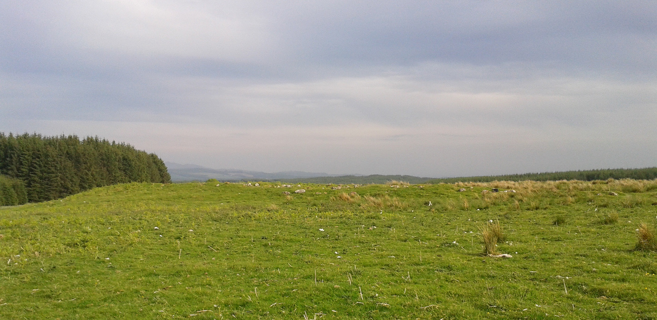
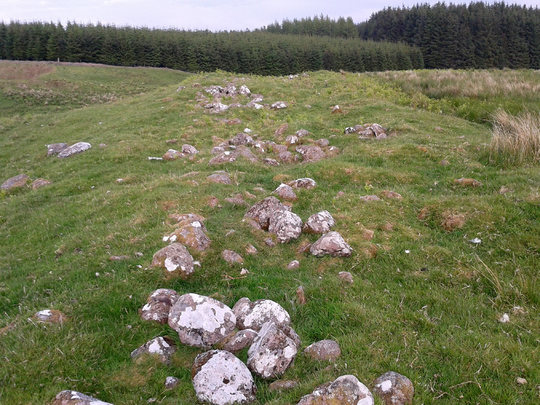
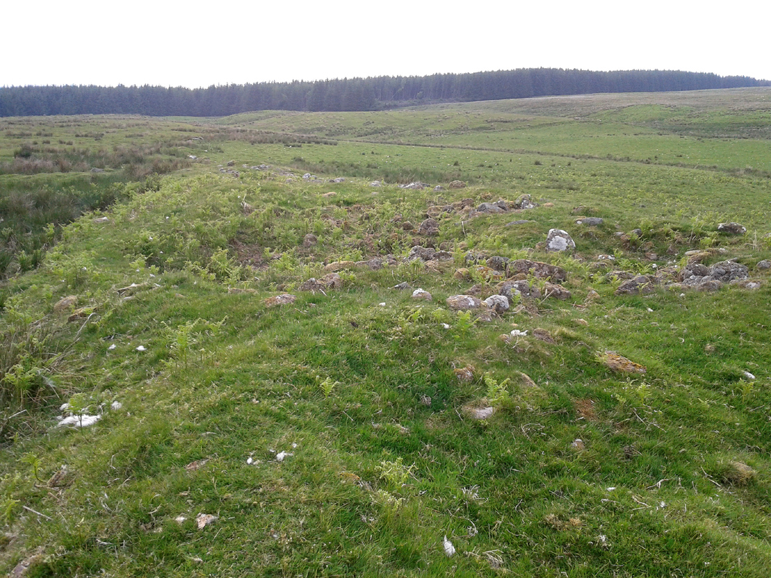
Take the B8033 north out of Dunblane and, immediately out the other side of Kinbuck, as you cross the river, take the first track on your left to Cromlix. Keep right along here to Cullings and beyond, till you reach the edge of the forestry plantation. Go left instead of going into the trees and, instead, follow the edge of the woodland for about 750 yards. You’ll see the land rise up on the other side of the stream and the huge length of stones thereby. That’s it!
Archaeology & History
Main axis of the cairn
Not included in any major archaeology tomes, this giant long prehistoric pile of rocks—probably constructed in neolithic times—sits along the edge of a natural ridge, out of sight of all but the lone wanderer and the birds. Aligned ESE to WNW, this huge monument measures more than 61 yards (56m) in length and is 12 yards across at its present widest section. Much of the tomb has been severely robbed for stone in making the local walling: two of which emerge out of the structure itself—one running directly downhill from its larger eastern edge, and a more extensive wide line of walling running west and northwest for quite some distance. This western section of walling has the hallmarks of being constructed as far back as the Iron Age, which may be when the initial destruction of the chambered cairn first started. But, until we get an excavation here, we won’t know for sure.
Portion of the central mass of stones
Western wall leads to the cairn
The next closest tomb of any great size is the Judge’s Cairn, 1½ miles (2.4km) to the southwest. Clusters of smaller single cairns exist about nearly a mile northwest, with prehistoric settlement traces accompanying them—but nothing seems in immediate attendance to this Cromlix giant.
Other sites, obviously, await discovery in this area. We know that a spring of water roughly 50 yards east of here was used by so-called ‘witches’ in earlier centuries, for both healing and sympathetic magick. Whether this tradition ever had any relationship with the cairn is difficult to say.
References:
Royal Commission Ancient & Historical Monuments of Scotland, Braes of Doune: An Archaeological Survey, Edinburgh 1994.
Tumulus (destroyed): OS Grid Reference – NT 3076 7177
Archaeology & History
Long since gone, this little-known burial mound could once be seen not far from the old mansion of Niddrie House. The only reference I’ve found of it is in Thomas Whyte’s (1792) early essay on the parish of Liberton, where he told:
“East from the house and plantations, and on the north side of the public road, is a rising ground, or tumulus, called the Law Know, where, in more early times, judgment was dispensed, and where, probably, certain acknowledgments were made, by those who held of the baron or family. It is of a circular form. And this is the cafe with all places of the same kind. For they were considered as emblems of the sun, that great object of Druidical worship.”
The site appears to have been destroyed when the Industrialists blasted their quarry here and, as historians well know, quarrymen are dreadful when it comes to making notes of anything! Any additional info on this place would be good….
Cross (destroyed): OS Grid Reference – TQ 3077 8093
Also Known as
Stone Cross of the Strand
Archaeology & History
First mentioned in Latin manuscripts from 1274 CE, the best description of this long lost monument, curiously, appears to be in Gover’s Place Names tome. In a slightly edited format he told us the following:
“There was a stone cross “without the bar of the New Temple” traditionally supposed to have been erected by William Rufus “in devotion to the Holy Cross and for the health of the souls of himself and his mother, Queen Maud… It was in the Strand, possibly on the site of the present church of St. Mary. It is referred to as crucem lap’ in 1274; la Crois de Piere in 1293; …Stonecrouch in 1337; crucem fractum in 1342…”
In subsequent notes Gover et al (1942) tell of a man they found in historical records to be Thomas le Barber, “described alternatively as being Thomas le Barber atte Stonecourche” in the Calendar of Rolls records of 1337, and again in the 1339 accounts.
Of the cross itself, information is minimal and scattered. It was destroyed several centuries ago but is mentioned in a number of old books on the history of the city. The historian Thomas Allen (1829), for example, told that
“opposite to Chester Inn stood an ancient cross. On this cross in the year 1294, the judges sat to administer justice, without the City.”
It was also a site where legal pleas for the county of Middlesex were to be held, at “the Stone Cross of lad Straund” as it was then known. Due to the early administrative function delivered from this cross, it strongly implies the place to have been a moot site prior to the erection of the cross, probably dating from the period in which tribal elders met here.
A Mr Newton tells in his London in the Olden Time that the top of the cross was damaged and knocked off by the crazy christians around the time of the Reformation and that for many years stood headless. When Vallance (1920) came to describe it, he told merely that,
“the Strand Cross, near Covent Garden. This cross was hexagonal on plan, and comprised four stages. It was standing in 1547, but was ultimately removed, its site being occupied by the Maypole, which was spoken of in 1700 as new.”
The Strand Cross would have been on the ancient ley (not one of those ‘energy lines’ invented by New Age fantasists) described first of all by Alfred Watkins (1925)—running from St. Martins-in-the-Field to St. Dunstan’s in Fleet Street—but he seems to have been unaware that the monolith ever existed. The alignment was subsequently described in more detail in Devereux & Thomson’s (1979) work on the same subject, but its existence seems to have evaded them too! Chris Street (2010) did include it in his much more detailed walk down the same ley. A maypole was also known to exist close to the site of the cross; with one account showing that the two monuments existed at the same time in 1543.
As the site seemed to have been an early moot spot, the Strand Cross may have been an omphalos in early popular culture (before the christians of course), or at the very least, a site of popular animistic tradition.
In truly that most unholy of places in England—Westminster, London—there was, in bygone times, a slightly more sacred site which, earlier still, might have been where a standing stone stood…. Might…. But such days are long gone down there. A gathering place of local people in very early times, the Broken Cross was, according to Vallance (1920),
“erected by the Earl of Gloucester in the reign of Henry III (1216-1272), but it did not stand very long. Its site is said to have been ‘the place of the meeting of the Folkmote…near St. Martin’s-le-Grand, about midway between the Northgate of the precinct (of St. Paul’s) and the church of St. Vedast.’ On 5th September 1379, agreements were drawn up for letting the stations about the Broken Cross to five divers persons. The cross was bodily taken down in 1390.”
Yet its name was maintained in street-names for many years later, simply as ‘Broken Cross’. Its position would have been very close to Cheapside.
George Gomme (1880) pointed out that such early folk moots were the development of tribal gatherings grafted from megalithic meetings onto early christian assemblies, pointing out how such assemblies for laws and councils were made at nearby St. Paul’s as early as 973 AD.
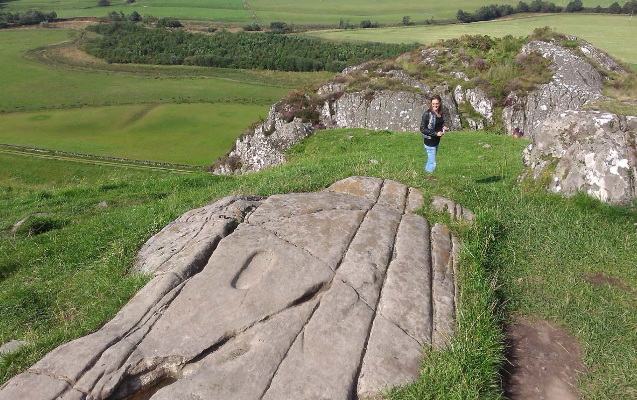
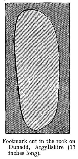
From Lochgilphead, take the A816 road north for several miles (towards the megalithic paradise of Kilmartin), keeping your eyes peeled for the road-signs saying “Dunadd.” Turn left and park-up a few hundred yards down. Go through the gate and walk up Dunadd. Just before the flattened plateau at the top, a length of smooth stone is accompanied to its side by the deep cup-and-ring of the Dunadd Basin. Three or four yards away, you’ll see the long ‘footprint’.
Archaeology & History
Near the top of Dunadd’s Iron Age ‘fortress’ and overlooking the megalithic paradise of the Kilmartin valley, several man-made carvings are in evidence very close to each other, all with seemingly differing mythic content. This one—the footprint—stands out; but it’s not alone! Faint etchings of at least one other ‘foot’ is clearly visible. The first literary account of it was by Ardrishaig historian R.J. Mapleton (1860), who told,
“There is on the top of Dunadd a mark that strikes me as interesting; it is like a large axe-head, or a rough outline of a foot. My impression is that it may have been the spot on which the chief would place his foot when succeeding to the headship of his tribe. The footmark was always considered among the people here as a mould for an axe-head, and I was rather laughed at for suggesting an inaugurating stone.”
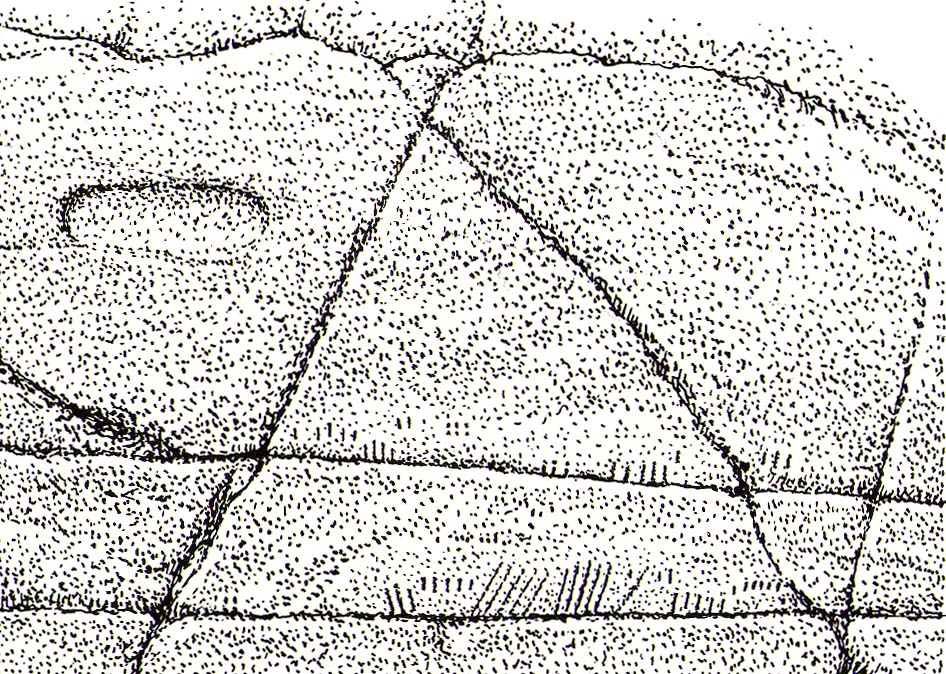
Dunadd Footprint (after Royal Commission 1988)F.W.K. Thomas’ 1879 sketch
Be that as it may, a few years later the carving had caught the attention of the Scottish Society of Antiquaries. In his article exploring the potential for ritual inaugurations at Dunadd, Captain F.W.L. Thomas (1879) explored, not only the footprint, but the mythic functions of this symbol, looking at parallels with petroglyphs elsewhere in the world where the ‘foot’ was known to be a ritual inauguration symbol (amongst other things). He gave us the first real detailed account of the carving:
“About 10 or 12 feet below, and to the northward of the highest point, the living rock is smooth, flat and bear of sward, and in it is engraved an impression of a footmark, not of a naked foot, but such as would be made when the foot is clothed by a thick stocking or cuaran… The engravure is for the right foot; and it exactly fitted my right boot. The footmark is sunk half-an-inch deep, with perpendicular sides, the surface is smoothed or polished, and the outline is regular… It has probably been sheltered by the turf until recently. The footmark is 11 inches long, nearly 4½ inches broad where broadest, and 3½ inches across at the heel. When a person stands with his foot in the depression, he looks a little easterly of north.”
A century or so later when the Royal Commission (1988) boys got here, they found not one, but two ‘feet’ carved into the rock! A few feet away, near to the carved boar,
“At the south end of the main rock surface there is the lightly-pecked outline of a shod right foot. 0.24m long and 0.1m in maximum width, with a pronounced taper to the heel. There are further peck marks within the outline, and a sunken footmark was intended but not completed. This print is on almost the same alignment as the more prominent footprint some 2m to the north, which measures 0.27m from NNE to SSW, by 0.1m in maximum width and 25mm in depth. It is somewhat broader at the heel than the incomplete mark, and its sides are straighter.”
Close-up of the carving
They then emphasize how we’re unable to date the footprints, although point out how such carvings are “found in Britain from the Iron Age onwards.” But footprints have be found on other petroglyphs in Scotland (much less in England) and date between the neolithic and Bronze Age periods—but whether Dunadd’s example goes that far back, we cannot say. Extensive excavations occurred at Dunadd between 1980-81 and most of the finds were Iron Age and early medieval in nature (this carving and the cup-and-ring barely got a mention in Lane & Campbell’s [2000] extensive summation). But we may be looking at an evolutionary developmental relationship in symbolism and form, if the traditions of the place have any substance. This is something I’ll return to when writing of the Boar Carving, just a few feet away…
Folklore
The legends behind this seemingly insignificant mark near the top of Dunadd ostensibly echo and relate to the huge cup-and-ring of Dunadd Basin four yards away. I can only repeat what I said in that site profile.
R.J. Mapleton (1860) said that Dunadd was known by local people to be a meeting place of witches and the hill of the fairies, whose amblings in this wondrous landscape are legion. Legends and history intermingle upon and around Dunadd. Separating one from the other can be troublesome as Irish and Scottish Kings, their families and the druids were here. One such character was the ever-present Ossian. Mapleton told:
“From these ancient tales we turn to a much later period of romance, when Finn and his companions had developed into extraordinary and magical proportions; a story is current that when Ossian abode at Dunadd, he was on a day hunting by Lochfyneside; a stag, which his dogs had brought to bay, charged him; Ossian turned and fled. On coming to the hill above Kilmichael village, he leapt clean across the valley to the top of Rudal hill, and a second spring brought him to the top of Dunadd. But on landing on Dunadd he fell on his knee, and stretched out his hands to prevent himself from falling backwards. ‘The mark of a right foot is still pointed out on Rudal hill, and that of the left is quite visible on Dunadd, with impressions of the knee and fingers.’”
As Mr Thomas (1879) clarified:
“The footmark is that of the right foot, and the adjacent rock-basin is the fabulous impression of a knee.”
References:
Bord, Janet, Footprints in Stone, Heart of Albion Press 2004.
Campbell, Marion, Mid-Argyll: An Archaeological Guide, Dolphin Press: Glenrothes 1984.
Campbell, M. & Sanderman, M., “Mid-Argyll: An Archaeological Survey,” in Proceedings of the Society Antiquaries, Scotland, volume 95, 1962.
Craw, J.H. “Excavations at Dunadd and other Sites,” in Proceedings of the Society Antiquaries, Scotland, volume 64, 1930.
Lane, Alan & Campbell, Ewan, Dunadd: An Early Dalriadic Capital, Oxbow: Oxford 2000.
Mapleton, R.J., Handbook for Ardrishaig Crinan Loch Awe and Pass of Brandir, n.p. 1860.
Morris, Ronald W.B., The Prehistoric Rock Art of Argyll, Dolphin Press: Poole 1977.
Royal Commission on the Ancient & Historical Monuments of Scotland, Argyll – Volume 6: Mid-Argyll and Cowal, HMSO: Edinburgh 1988.