Stone Circle (destroyed): OS Grid Reference – NY 88542 74175
Archaeology & History
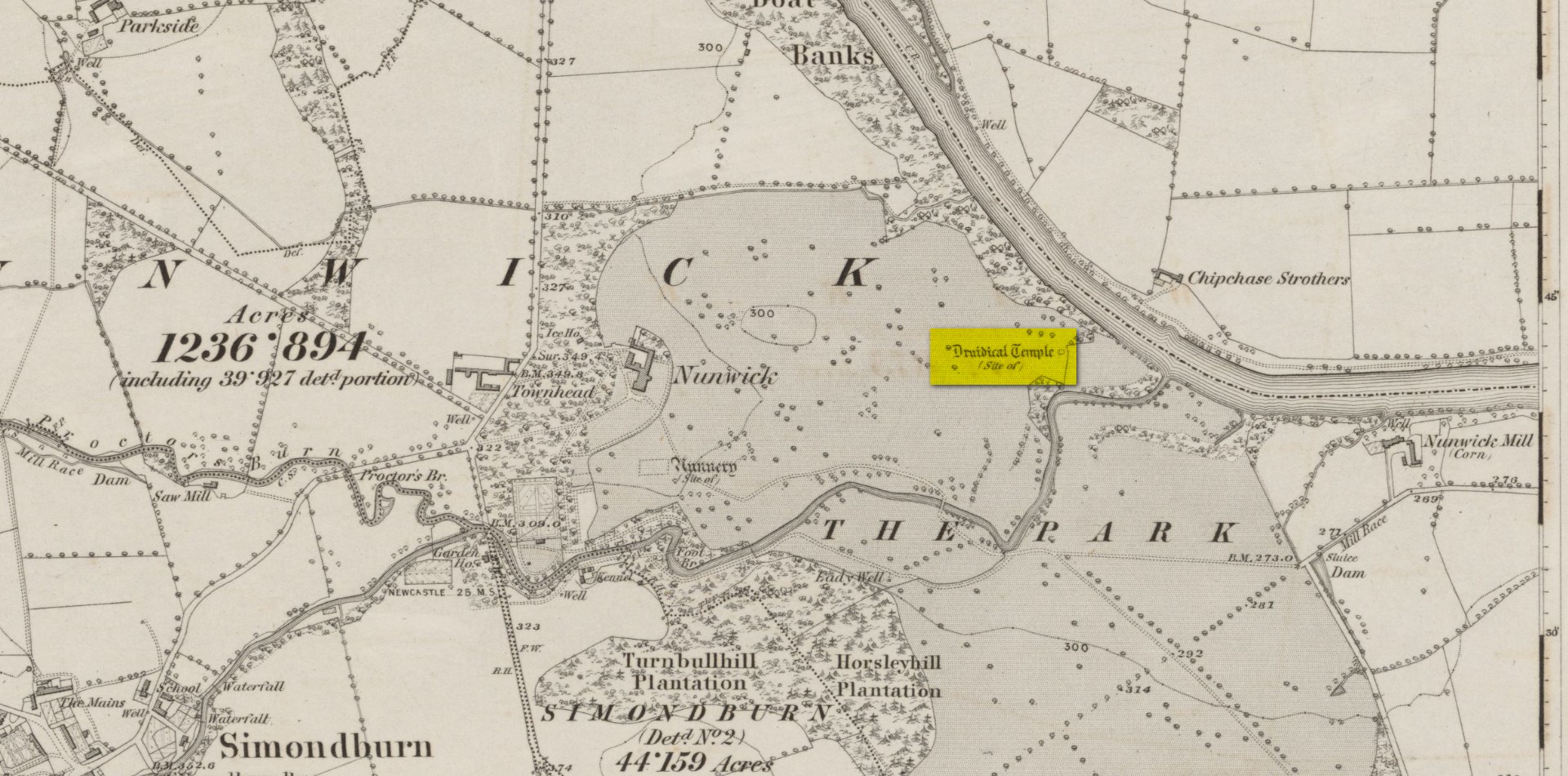
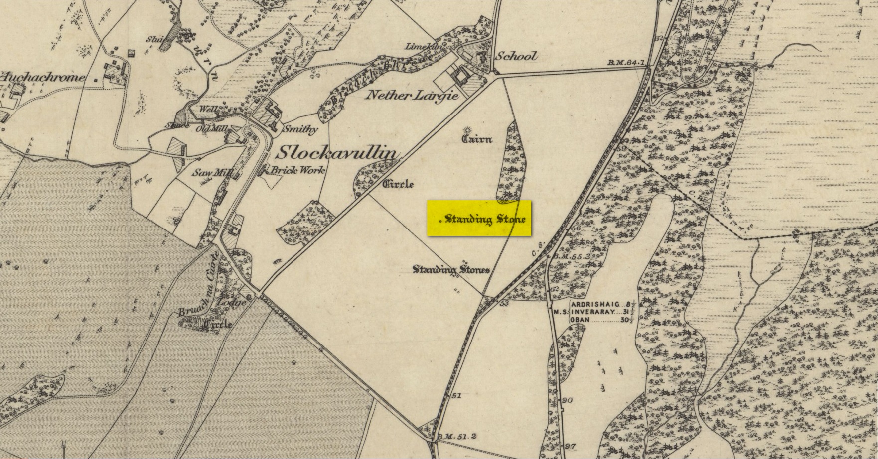
Site location on 1866 map
Highlighted, albeit in the past tense, as a “Druidical Temple” on the first Ordnance Survey map of the area in 1866, these megalithic remains were seen by earlier antiquarians, but seemingly met their demise sometime in the early 19th century. Some halfwit land-owners no doubt wanted their little garden extended to where local folk would have traditionally met at certain times each year—so in getting rid of the stones, it would help to keep the riff-raff away. (many of these elitists still think this way) It had certainly gone when the Northumbrian historian John Bates (1895) wrote about it, where he told simply:
“The fine circle at Nunwick, on North Tyne, described by Bishop Gibson, has long since disappeared.”
It was still standing in the 17th century, three or four thousand years after our ancestors put it there. We know this because the remains of the stone circle were told about in Gibson’s (1695) edition of Camden’s Britannia, where mention is made of “large stones erected at several places” in Northumberland, including this place where,
“near Ninwick in the Parish of Simondburn, four such stand still erected, and a fifth lies fall’n to the ground.”
The situation hadn’t changed when John Wallis (1769) visited Nunwick. On his trip to these megaliths he told that,
“In an adjoining field, called, Nunwick-east-field, were five upright stone-pillars, in a circular order; four of them perfect and entire in 1714, the other broken; the perfect ones eight feet high, and nine feet and an half over; the circumference of the area in which they stood, ninety feet.”
It was obvisouly a decent-sized circle! The great megalithic archaeologists Barnatt (1989) and Burl (2000) included the site in their respective catalogues, but could add no further details apart from saying there was a drawing made of the stones sometime around 1715 which, apparently, is in volume 15 of the History of Northumberland. Has anyone got a copy…? 🙂
References:
Barnatt, John, Stone Circles of Britain– volume 2, BAR: Oxford 1989.
Bates, John C., The History of Northumberland, Elliot Stock: London 1895.
Burl, Aubrey, The Stone Circles of Britain, Ireland and Brittany, Yale University Press 2000.
Dodds, M.H. (ed.), A History of Northumberland – volume 15: Simonburn, Rothbury, Alwinton, etc, Andrew Reid: Newcastle-upon-Tyne, 1935.
Gibson, Edmund (ed.), Camden’s Britannia, F. Collins: London 1695.
Wallis, John, The Natural History and Antiquities of Northumberland – volume 2, W. & W. Strahan: London 1769.
Acknowledgements: Huge thanks for use of the Ordnance Survey map in this site profile, reproduced with the kind permission of the National Library of Scotland.
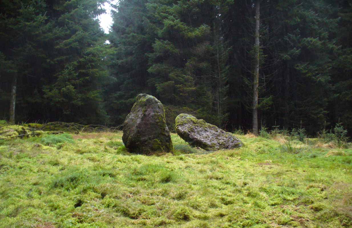
From Pitlochry town centre, walk down the A924 high street as if you’re going to the Blair Atholl Distillery, but just before it take the right-turn and go over the river, and just keeping walking along this road for a third-of-a-mile (0.5km) until your reach a small small on your left that swerves up the hill (there’s a little signpost here saying Cluny Path to Strathtay). Go up and across the main road, then just keeping walking up the dirt-track, which becomes a footpath, and heads further uphill into and through the woodland. Make a bittova daydream from the walk up here, making sure to keep to the path closest to the burn (stream) on your left. Eventually when it levels out, you’re very close. Just keep on the same track and, where it meets up with another, bear left and about 100 yards along, on a small rise in the trees on your right, you’ll see these old stones peeking out. Keep your wits about you!
Archaeology & History
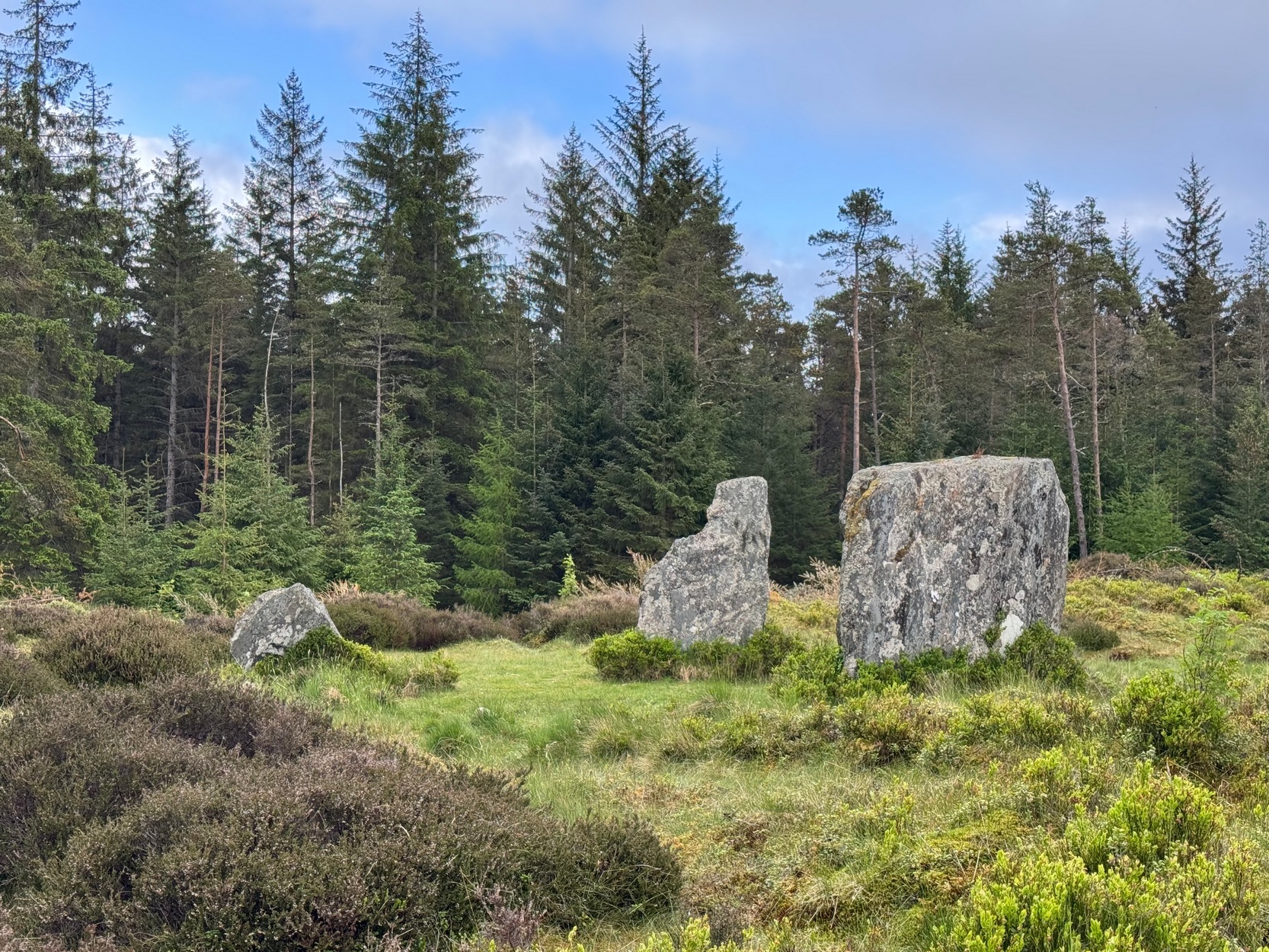
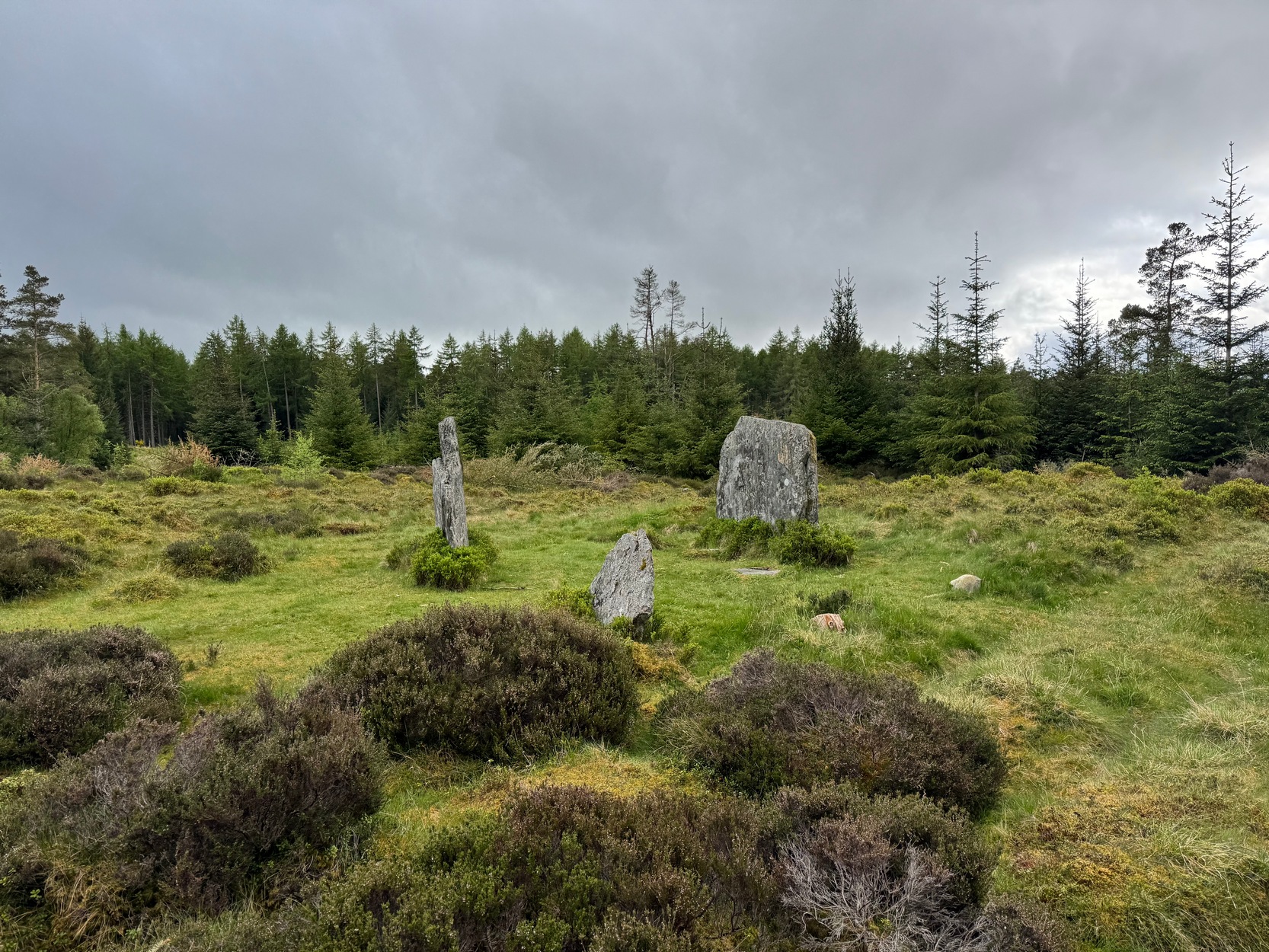
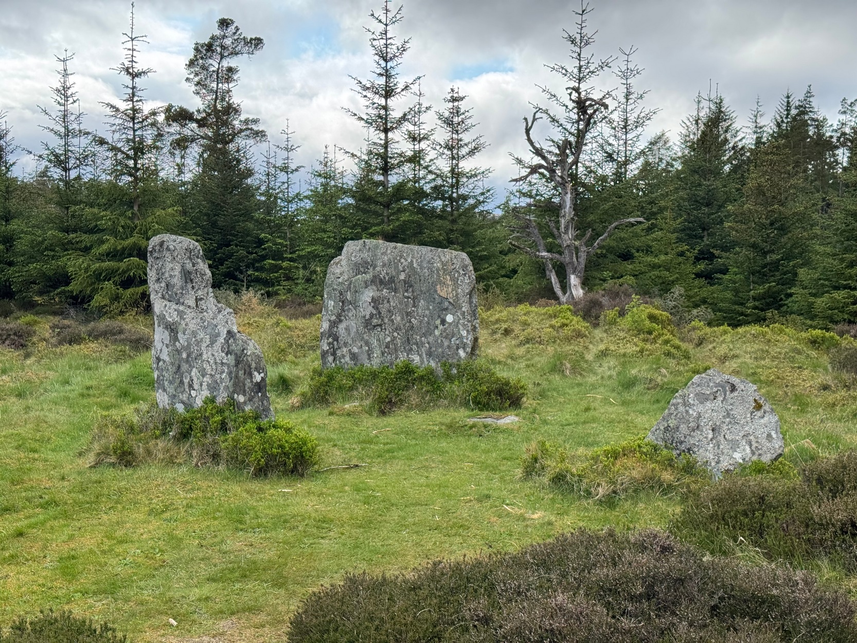
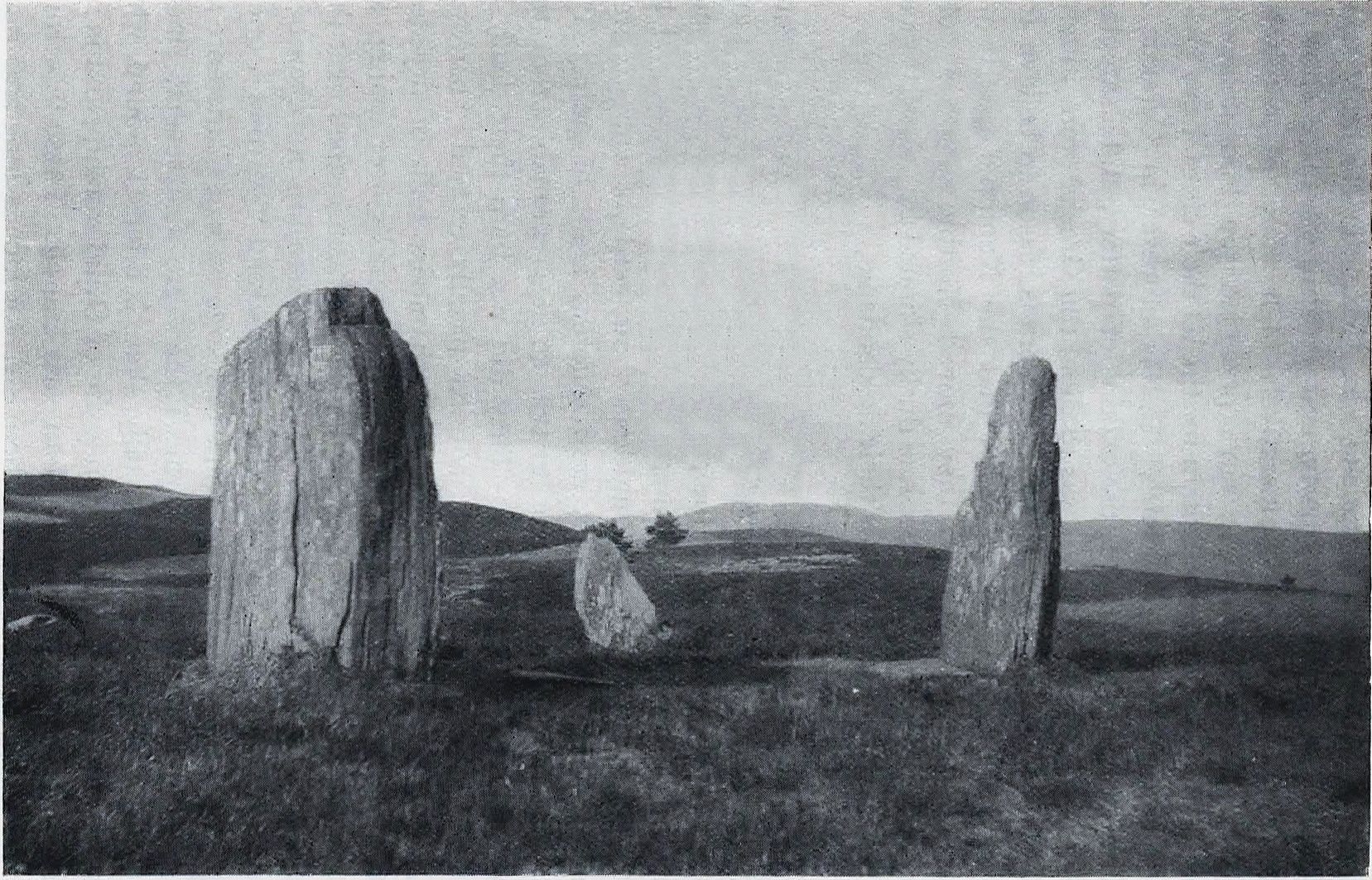
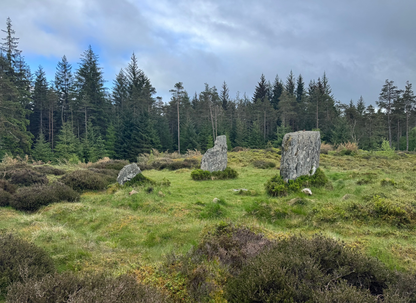
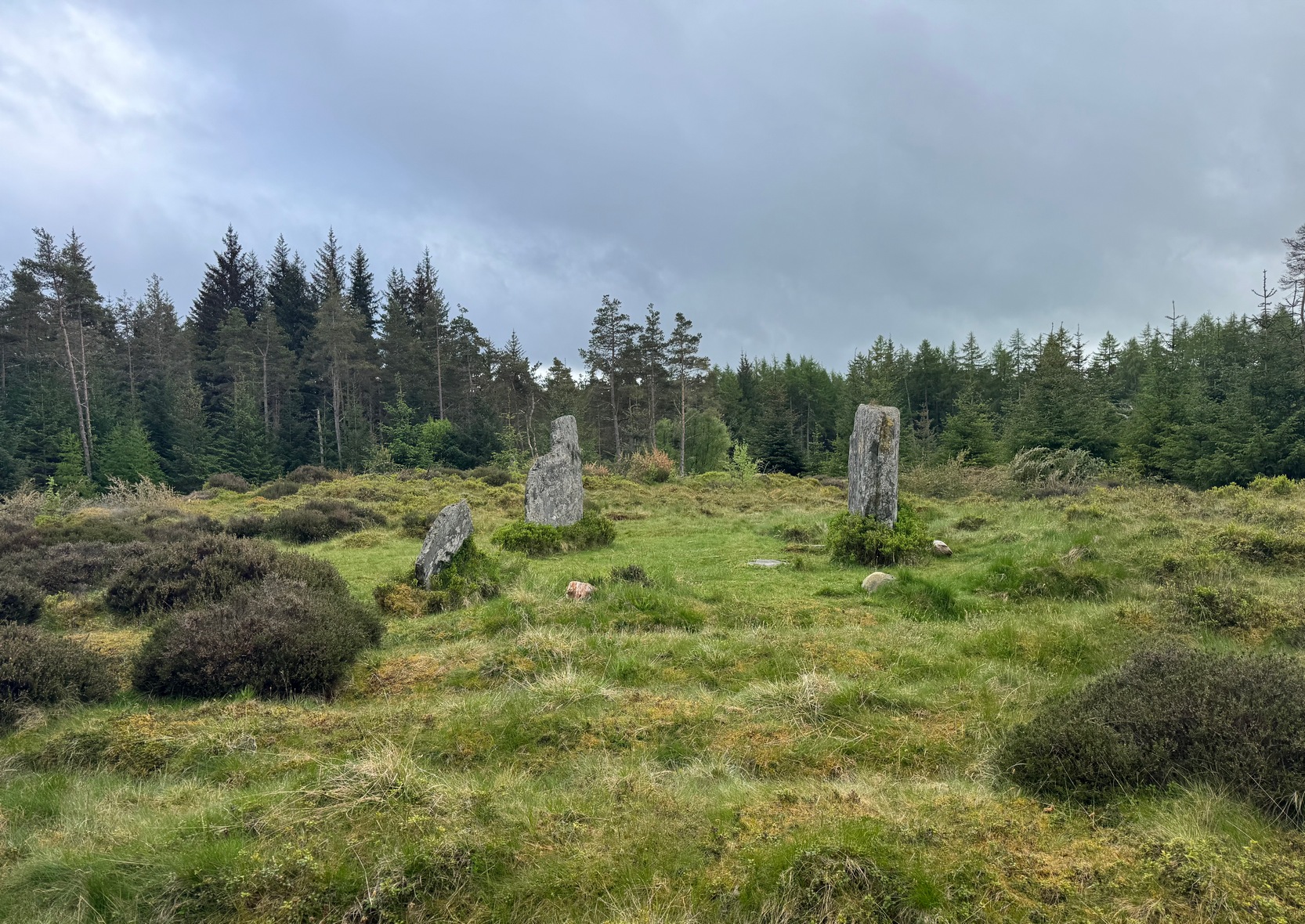
Clachan an Diridh looking E
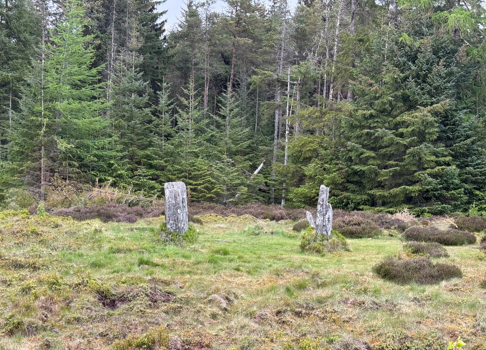
Sat high up on open moorlands with views all round… is what this site used to look like. Sadly, the forestry commission have almost completely enclosed this prehistoric site, making any view of the surrounding landscape all but impossible. I’m not the first and won’t be the last person to be pissed-off by such thoughtlessness. Alexander Thom made mention of it too. After making an initial assessment of the astronomical alignments at these stones in 1967, “when we returned to measure the horizon we found that trees had been planted round the stones and so we failed.” (Thom 1990) Not good.
On my first visit here, as I entered this “stone circle” my first impression was that it wasn’t a circle at all, but the remnants of a megalithic stone row! Thom thought the same. It’s the slender thin stature of the stones that do it to you: they almost cut the air and point the enquiring nose dead straight along the same angle that all the stones have been deliberately aligned to. I assume they’ve had a similar effect on other people over the years.
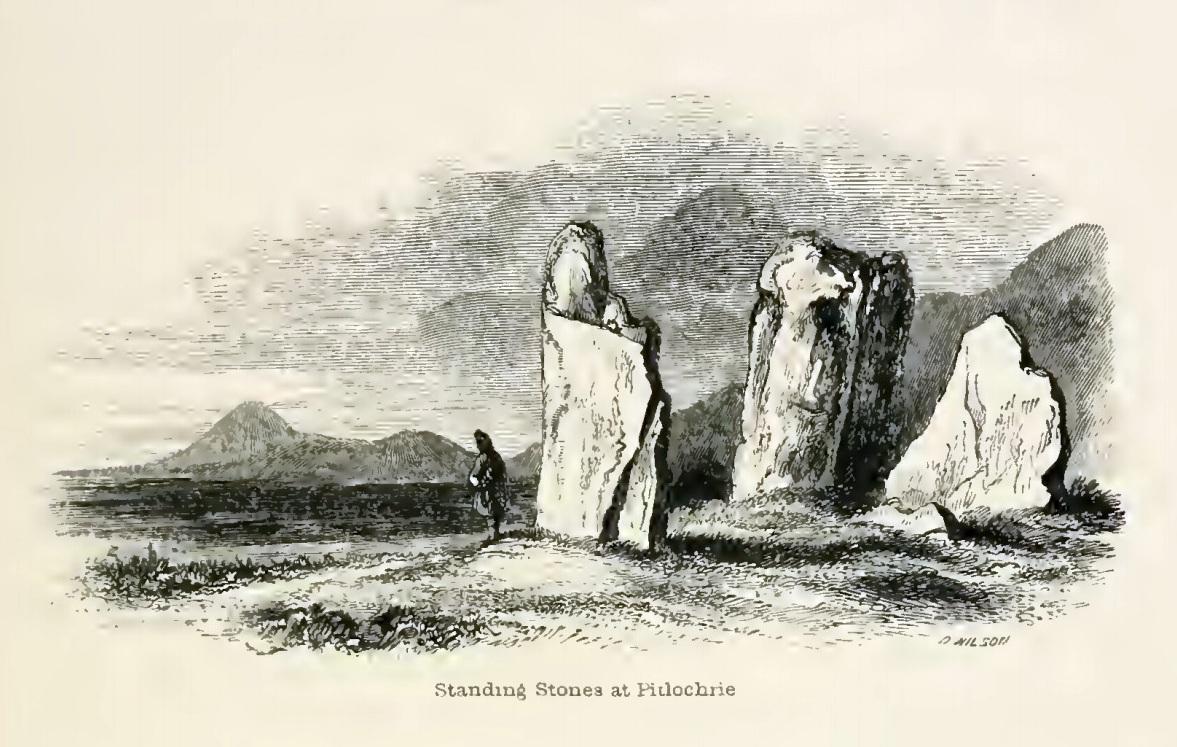
The Clachan an Diridh, or the Stones on the Ascent, were first mentioned in Dan Wilson’s (1851) major survey and who was so impressed by the view from here and its setting in the landscape that he compared its visage to Stonehenge. Were it not for the short-sightedness of the Forestry Commission destroying the view, most would no doubt agree with Wilson’s sentiments. From these olde stones, he told:
“One of the great level Highland moors stretches away beneath the eye, like a dark waveless lake, contrasting with the distant heights, among which Ben Lawers rears its pyramidal summit to an elevation of upwards of 4000 feet above the level of the sea. Amid this wild Highland landscape the huge standing stones, grey with the moss of ages, produce a singularly grand and imposing effect; and from the idea of lofty height which the distant mountains suggest, they convey a stronger impression of gigantic proportions than is produced even by the first sight of the giant monoliths of Salisbury Plain.”
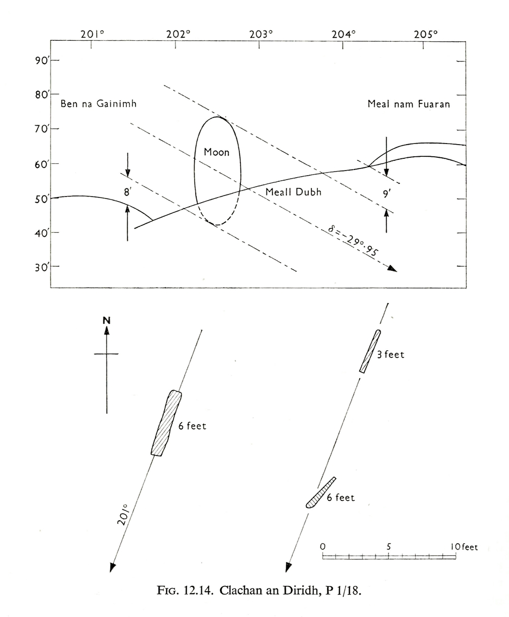
Thom’s initial moonset alignmentThom’s 1980 ground-plan with marker stone
The giant figure of Ben Lawers, if we could see it today, would rise to the southwest 20 miles (32km) from here; and the great pyramidal fairy mountain of Schiehallion would be equinox west, 13 miles (21km) away. Yet curiously when Alexander Thom surveyed the outlying hills, he didn’t think either of these mountains had any worth, astronomically speaking that is. Yet Lawers in particular would be the largest point on the southwestern horizon, rising in the distance, way beyond the wide rolling U-shaped glen of Strathtay to where the landscape changes into more rugged dynamic uplands. And the importance of Lawers as a place in prehistory is shown by the mass of petroglyphs across its slopes—particularly the side you could see from Clachan an Diridh.
Instead, Thom (1967) looked much further to the southwest—south-southwest in fact—where he initially thought that there was an alignment to the major southern moonset ten miles away above the rugged hill of Meall Dubh, framed on either side by the mountain peaks of Meall nam Fuaran and Beinn na Gainimh. Aubrey Burl (1988) told how Thom later discounted this alignment and instead turned his attention a full 180° where a large stone on the hillside to the north-northeast caught his theodolytic eye. This marked an alignment towards the peak of Ben Vrackie:
“There is little doubt,” he wrote, “that this is a lunar site showing perhaps…at the major standstill. Could one side of the southern 6ft high stone possibly have indicated the setting point of the Moon at minor standstill?” (Thom 1990)
Clachan an Diridh in 1851Clachan an Diridh, c.1920
Thom looked at these stones and the landscape with the mind of an astronomer, whereas I’m more in preference of the aborigine who sees the feel of the landscape to discern relationships and meanings. Sometimes, of course, the sky and the landscape come together and that universal mythic union of heaven and Earth finds importance at a site. I have little doubt that such a mythos was once known here, on the moorland plateau, under the clear stars with the darkness reaching to speak with Lawers and other bones of landscape in the solid darkness of mountain silhouettes and fading horizons. Many a sleep at this site would have touched minds with Wonder…
Anyway, all that aside…
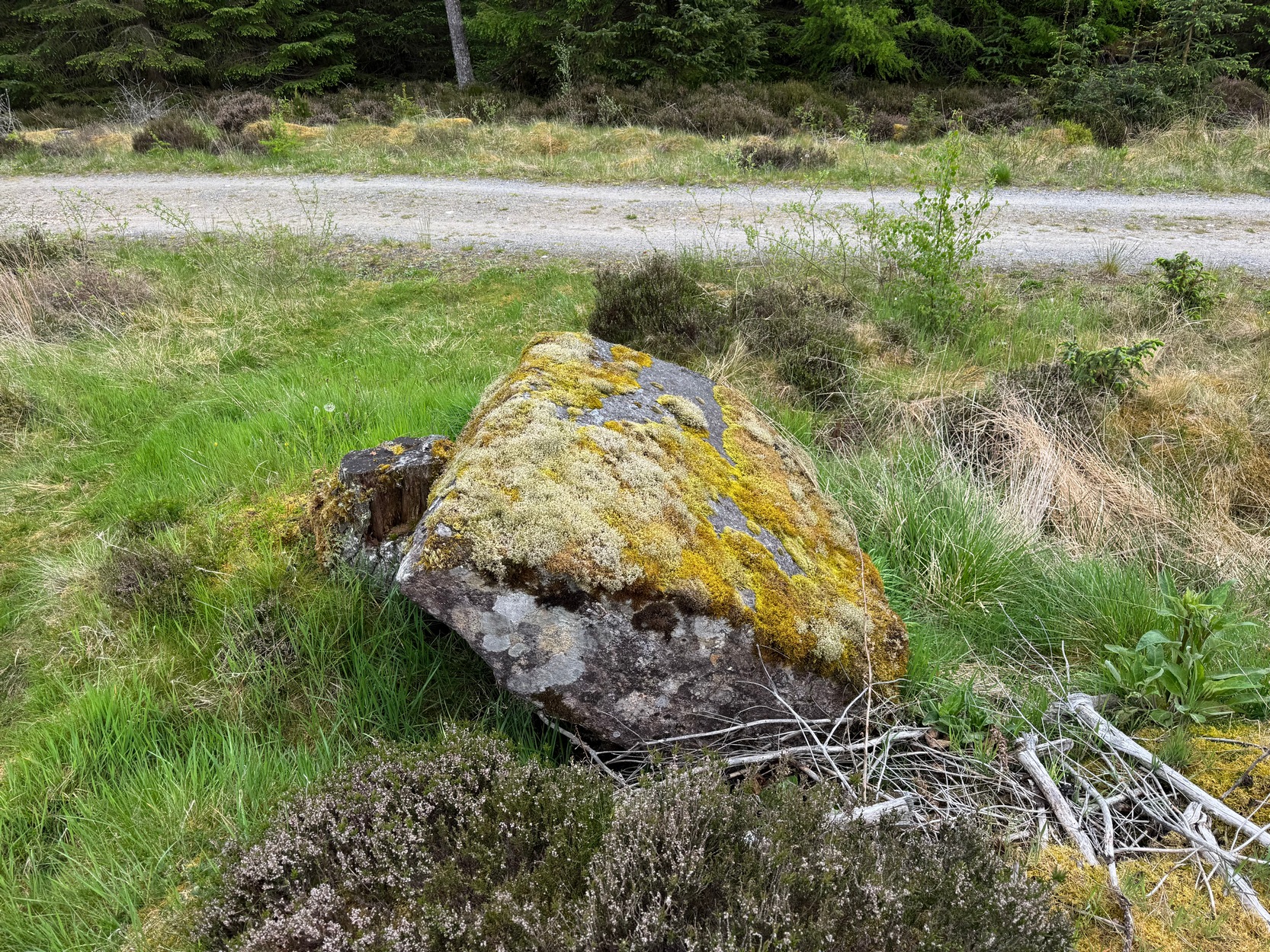
Large fallen stoneSite on the 1899 OS-map
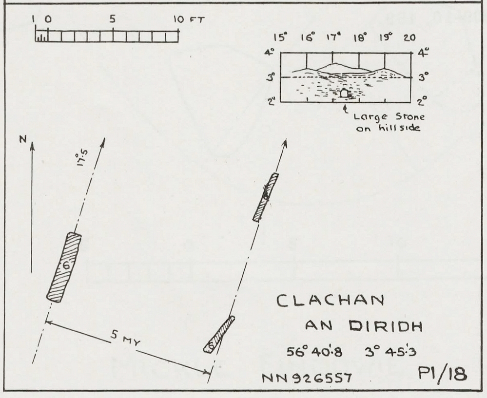
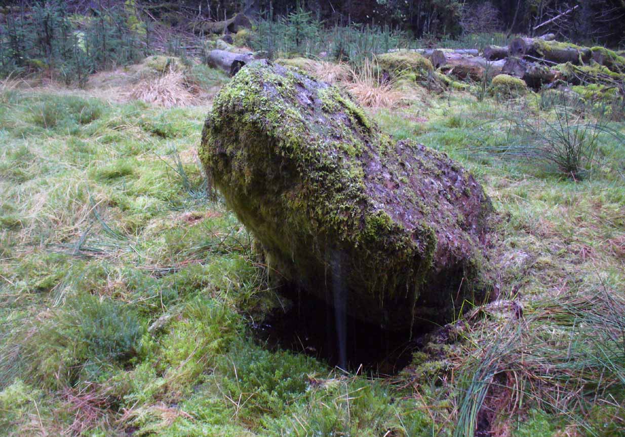
These megaliths have been classified as one of Aubrey Burl’s “four posters”, i.e., a rough square of four megalithic uprights, in spite of there only being three standing stones here. Even when Dan Wilson (1851) wrote about the place there were just three of them. However, down the slope from the stones, just off the recent trackside, there’s a decent contender for the fourth stone lying on its side in the undergrowth, half-covered in moss. It’s certainly fallen or rolled down the slope and its size and shape suggest that it may once have stood upright. Have a thoughtful fondle of it while you’re here.
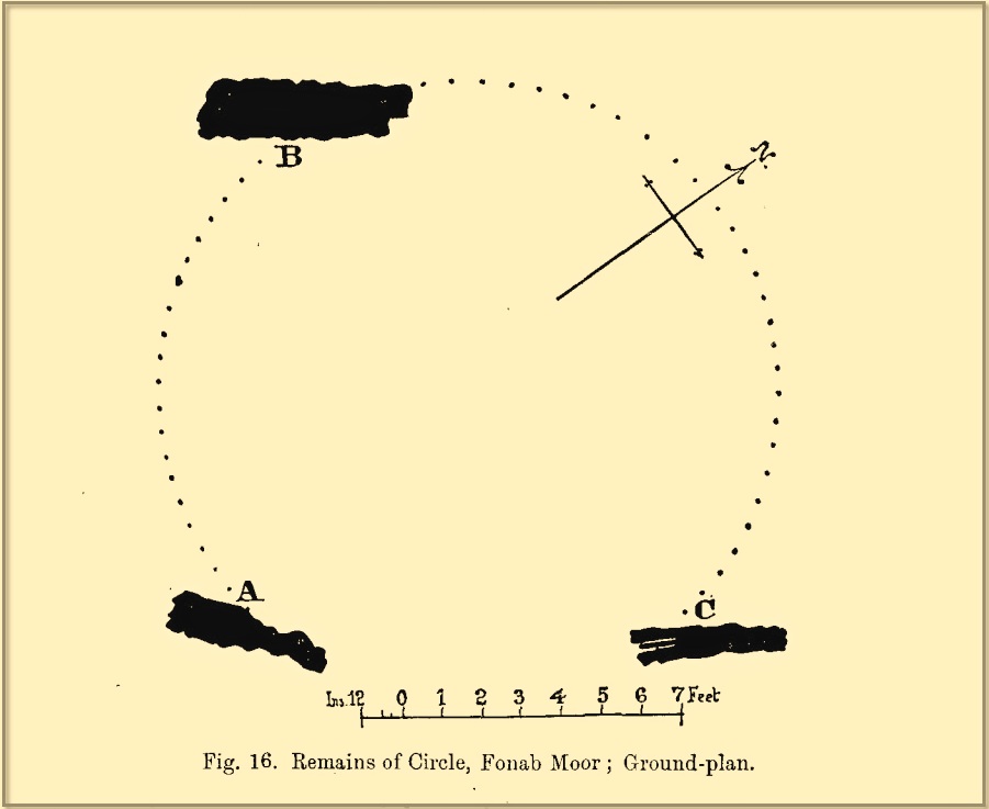
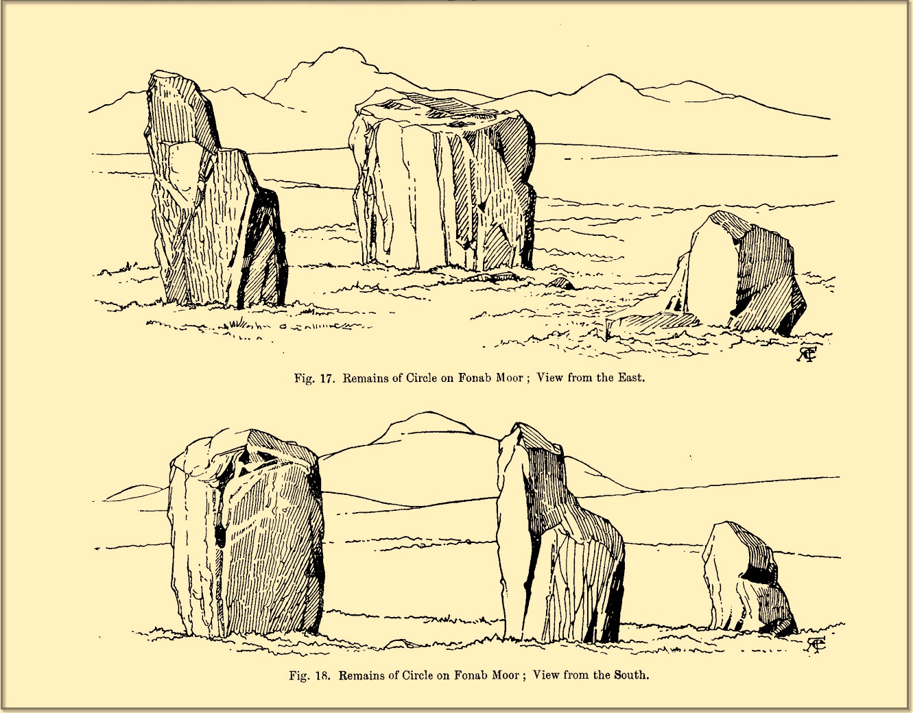
The ‘circle’ was highlighted on the 1899 OS-map and, a few years later, was visited and surveyed by the great Fred Coles (1908) and like Dan Wilson before him, told the view from here to be “very grand.” He continued:
Coles 1906 planColes’ views, from S & E
“In local parlance this group is known as the Four Stones. This must be a fairly old name handed down through some generations; because, for at least fifty-seven years past, only three Standing Stones have remained in situ. These three Stones are arranged as shown in the plan…in a group forming in its now imperfect condition a triangle which, measured from the centres of the Stones, has its SE side 11 feet 6 inches long; its SW side 12 feet 3 inches ; and its north side 16 feet 3 inches. Fragments of the demolished fourth Stone lie about the ground; but there is no clear indication of its original position. The South Stone, A, is 3 feet 7 inches in breadth, 5 feet 10 inches in height, and from 12 to 4 inches in thickness. The West Stone, B, 6 feet in height, measures 5 feet at the back, and 4 feet 10 inches at the front, and is 18 inches in thickness. The East Stone, C, at its outer angle is 3 feet 3 inches above ground, and leans inward. All the blocks are of quartziferous gritty sandstone, the East Stone being particularly rough and fissured. A large fragment lying near it seems to be a portion of it. The Stones are set upon a fairly true Circle with a diameter of 15 feet 4 inches. One feature quickly arrests notice: this is, that the broader faces of these Stones are not set even approximately upon and in line with the circumference, but nearly parallel with each other—an arrangement quite unlike the setting of Stones in the many other Circles hitherto surveyed.”
When Burl (1988) added this site to his Four Posters survey he merely echoed Coles’ early description, adding that, in his view, the standing stones that we see today were probably, originally, “set out on the circumference of a circle 20ft (6.1m) in diameter.”
I think it’s likely that there would have been more prehistoric sites in the vicinity, but a notable oddity is the almost complete absence of other recorded sites anywhere nearby. Of course, if there was anything, those thoughtful Forestry Commission heads would have destroyed it. We are left, simply, with the old but reliable notes of Messrs Dixon (1923) and Mitchell (1925) who told that, in their days, other remains did exist nearby in the form of ancient cairns and hut circles—‘Pictish’ according to tradition. If we’re lucky, some damaged parts of them might still be found at the edges, a short distance to the north west…
Folklore
In Hugh MacMillan’s (1901) gorgeous literary sojourn along Strathtay, he strayed somewhat from his otherwise historical notices by telling that here,
“on the highest part of the moorland…is a group of ‘clachan iobairt’, or stones of worship, where the Druids of old performed their mysterious rites, going round the circle of standing stones from east to west with the sun, or the ‘car deasal’, the lucky side, when they wished to invoke a blessing upon their friends, and going round the circle in the opposite direction, from west to east, the ‘car tuathsel’, or unlucky side, when they wished to pronounce a curse upon their foes.”
Whether this was what Hugh Mitchell (1923) meant when he referred to the traditions surrounding Clachan an Dirirdh we don’t know, but he echoed MacMillan’s account (though made no reference of his words), also adding that it was a site that “was visited on the first of May” or Beltane by some local people….
References:
Burl, Aubrey, Four Posters: Bronze Age Stone Circles of Western Europe, BAR 195: Oxford 1988.
Burl, Aubrey, A Guide to the Stone Circles of Britain, Ireland and Brittany, New Haven & London 1995.
Burl, Aubrey, The Stone Circles of Britain, Ireland and Brittany, Yale University Press 2000.
Dixon, John H., Pitlochry, Past and Present, L. Mackay: Pitlochry 1925.
Kennedy, James, Folklore and Reminiscences of Strathtay and Grandtully, Munro Press: Perth 1927.
Liddell, Colin, Pitlochry – Heritage of a Highland District, PKDL: Perth 1993.
MacMillan, Hugh, The Highland Tay: From its Source to Dunkeld, H. Virtue: London 1901.
Mitchell, Hugh, Pitlochry District: Its Topography, Archaeology and History, L. Mackay: Pitlochry 1923.
Omand, Donald (ed.), The Perthshire Book, Birlinn: Edinburgh 1999.
Stevenson, J., “Prehistory,” in Omand’s The Perthshire Book, Edinburgh 1999.
Thom, Alexander, Megalithic Sites in Britain, Oxford University Press 1967.
Thom, Alexander, Megalithic Lunar Observatories, Oxford University Press 1971.
Thom, A., Thom, A.S. & Burl, H.A.W., Megalithic Rings, BAR: Oxford 1980.
Thom, A., Thom, A.S. & Burl, Aubrey, Stone Rows and Standing Stones – volume 2, BAR: Oxford 1990.
Wilson, Daniel, The Archaeology and Prehistoric Annals of Scotland, Sutherland & Knox: Edinburgh 1851.
Acknowledgements: Huge thanks for use of the Ordnance Survey map in this site profile, reproduced with the kind permission of the National Library of Scotland.
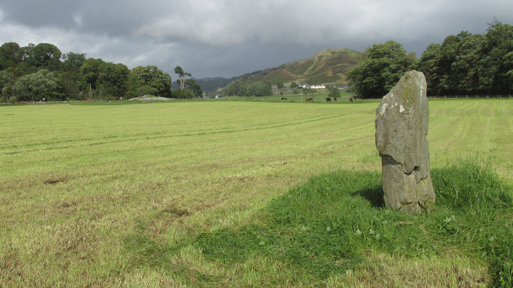
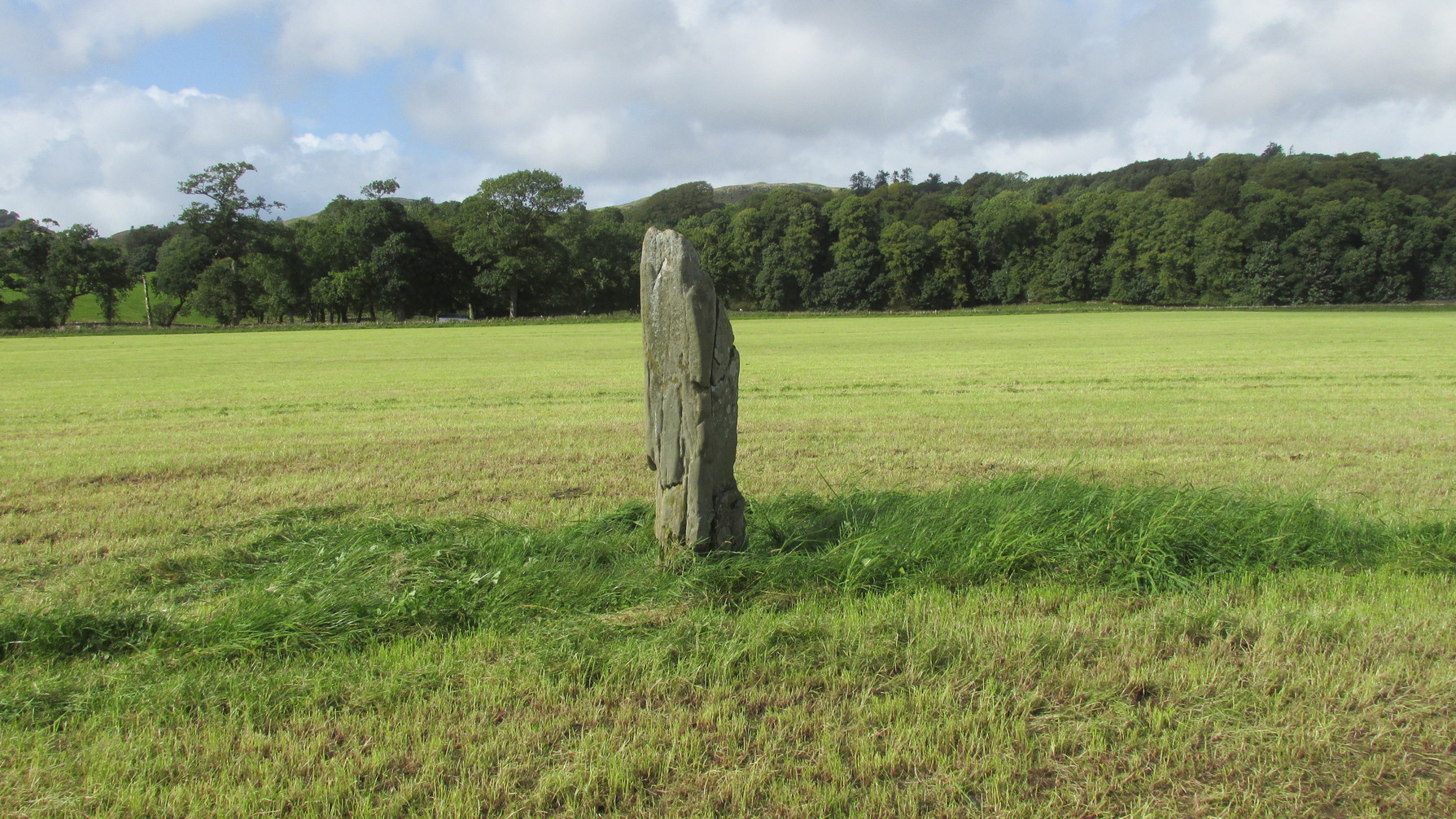
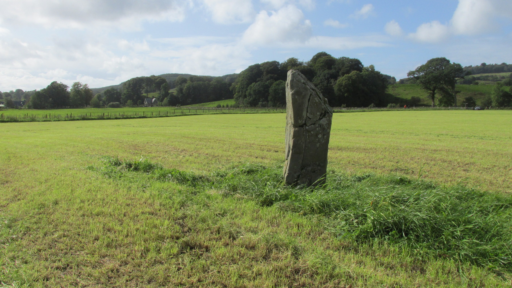
Along the A816 road, just less than a mile south of Kilmartin, take the right-turn on the B8025 Tayvallich road. Barely 50 yards along here, park up on the left-side of the road. Cross the road and walk along the well-marked footpath to the mighty megalithic Kilmartin ‘X’. The path continues to Temple Wood but you’ll see, in the field to your right, this single standing stone. (you’ll see the mighty Netherlargie South cairn in the field beyond)
Archaeology & History
Stone on the 1874 OS-map
First illustrated on the 1874 Ordnance Survey map, this solitary stone (though it may once have had companions) stands some 200 yards south-east of the Temple Wood circle and 355 feet north-west of the northernmost stone in the Kilmartin ‘X’ megalithic complex. When Alexander Thom surveyed this area, despite finding astronomical alignments at many of the standing stones nearby, he could find no heavenly association at this solitary monolith. Its function remains hidden for the time being, although everyone assumes it had some relationship with the giant tombs close by. It makes sense.
Looking W to Temple WoodLooking to the southwest
Despite being referenced in a number of prehistoric surveys, archaeological circles say very little about it. When the Royal Commission lads (1988) visited here they told how it was, at the time, leaning to the south-east. It fell over a few years afterwards but has thankfully been resurrected. When the archaeologists fondled around the base of where it had stood, apart from a few packing stones at one side of the monolith, nothing was found.
Pearson, Jane, Kilmartin – The Stones of History, Famedram: Alexandria 1975.
Ritchie, Graham, The Archaeology of Argyll, Edinburgh University Press 1997.
Royal Commission on the Ancient & Historical Monuments of Scotland, Argyll – Volume 6: Mid-Argyll and Cowal, HMSO: Edinburgh 1988.
Ruggles, Clive, “The Stone Alignments of Argyll and Mull,” in Records in Stone (ed. C.L.N. Ruggles), Cambridge University Press 1988.
Thom, Alexander, Megalithic Lunar Observatories, Oxford University Press 1971.
Acknowledgements:Huge thanks for use of the Ordnance Survey map in this site profile, reproduced with the kind permission of the National Library of Scotland.
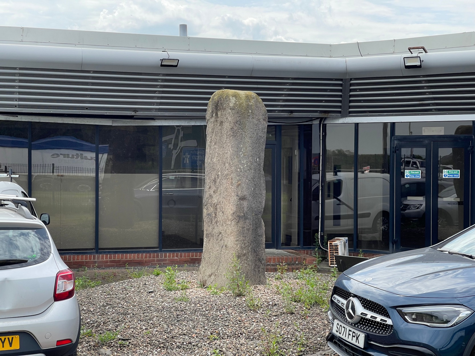
Coming out of Edinburgh along the main A8 Glasgow road, literally yards before you join the M9 near Ratho Station, on the left-side of the road where the last building stands (a company called Element), you need to look through their high metal fence. Just in front of the large windows, you’ll see this tall standing stone (if you’re coming here via public transport, there’s a bus-stop less than 100 yards away on both sides of the dual carriageway). Y’ can’t really miss it!
Archaeology & History
A prehistoric site which, today, has lost all value in terms of its original ambience. The traffic and aircraft noise here is non-stop and prevents all forms of quietude and refection. Added to this is the fact that it’s behind the high fencing of the warehouse, stopping you getting close to it. But, I suppose, at least it’s still standing after all these centuries. In many other parts of Britain, it would have been destroyed long ago…
It seems to have been mentioned for the first time, albeit briefly in John Smith’s (1862) early survey of the local prehistoric sites. He told it to be a,
“large standing stone…of coarse greenstone,” which “bears no inscription or sculpturing of any kind, and measures about 10 feet in height from the surface of the ground.”
Old stone, new home
Many years later when the Royal Commission (1929) this way ventured, they weren’t much more descriptive, but postulated, not unreasonably I might say, that it functioned as a deliberate outlier from the impressive Newbridge megalithic complex 350 yards to the west. They may be right. “In shape it is an irregular four-sided prism,” they wrote, “measuring 9 feet 3 inches in height and 10 feet 6 inches in girth.” The local megalith surveyor Adam MacLean (1977) pointed out that, relative to the prehistoric complex 350 yards away, “it is in the right position to act as an equinox sunrise marker.”
References:
MacLean, Adam, The Standing Stones of the Lothians, Megalithic Research Publications: Edinburgh 1977.
Royal Commission Ancient & Historical Monuments of Scotland, Inventory of Monuments and Constructions in the Counties of Midlothian and West Lothian, HMSO: Edinburgh 1929.
Swarbrick, Olaf, A Gazetteer of Prehistoric Standing Stones in Great Britain, BAR: Oxford 2012.
Acknowledgements:Huge thanks for use of the Ordnance Survey map in this site profile, reproduced with the kind permission of the National Library of Scotland.
Ardoch (2) carving, with Milquhanzie hillfort behind
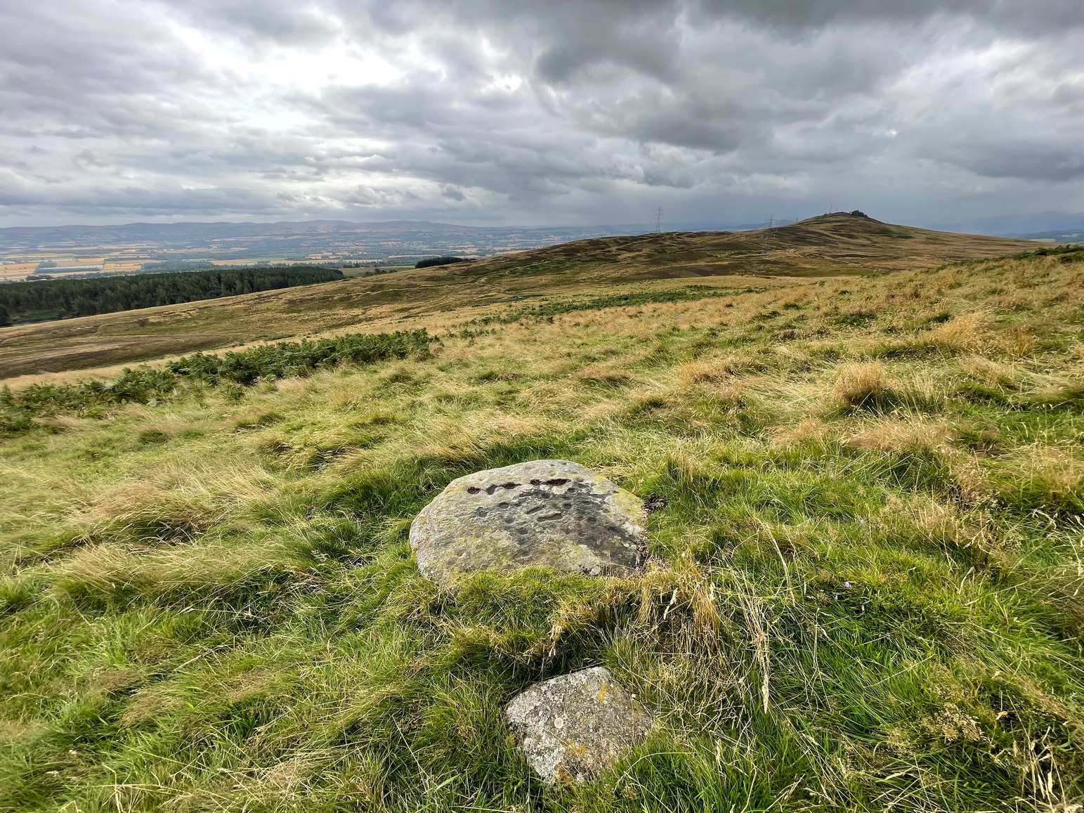
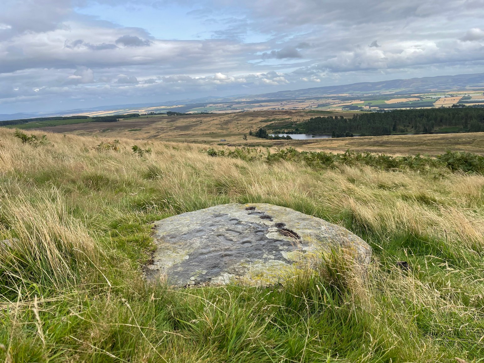
We took the long route to get here, via Fowlis Wester village, up to the car-park near the standing stones, then walk for 1¾ miles along the track: past the stones, veering right to go downhill then uphill, past the Ardoch (1) petroglyph and bearing right at the next split in the track, then right again at the next split. Then, crossing a small burn and curving round the next bend, keep your eyes peeled for the track-cum-footpath that reaches uphill on your right (NE). A shorter route is via the Foulford golf course (found along the A822 roughly halfway between Gilmerton and the entrance to the Sma’ Glen): take the track from there, eastwards into the hills, and literally ¾-mile along you reach the pylon; keep walking along the track for another 200 yards and on your left watch out for the same track-cum-footpath. Walk up there for about 400 yards and, 35 yards to the right of the fence, you’ll see a large flat stone.
Archaeology & History
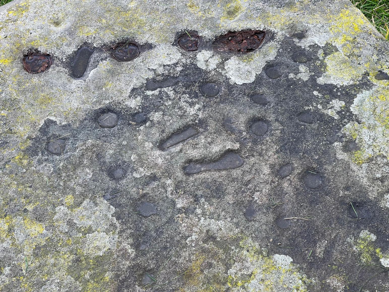
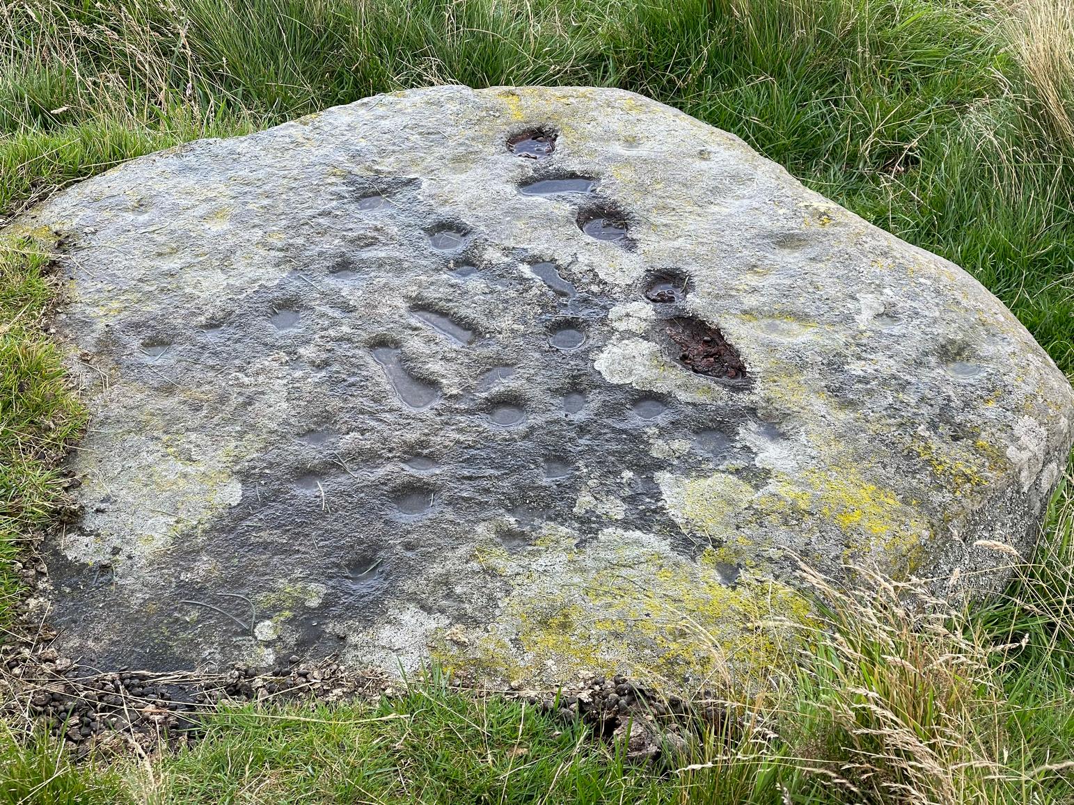
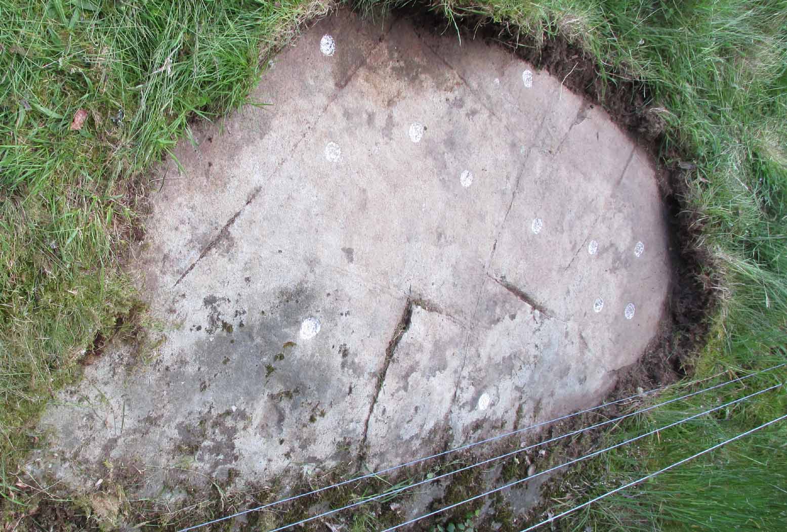
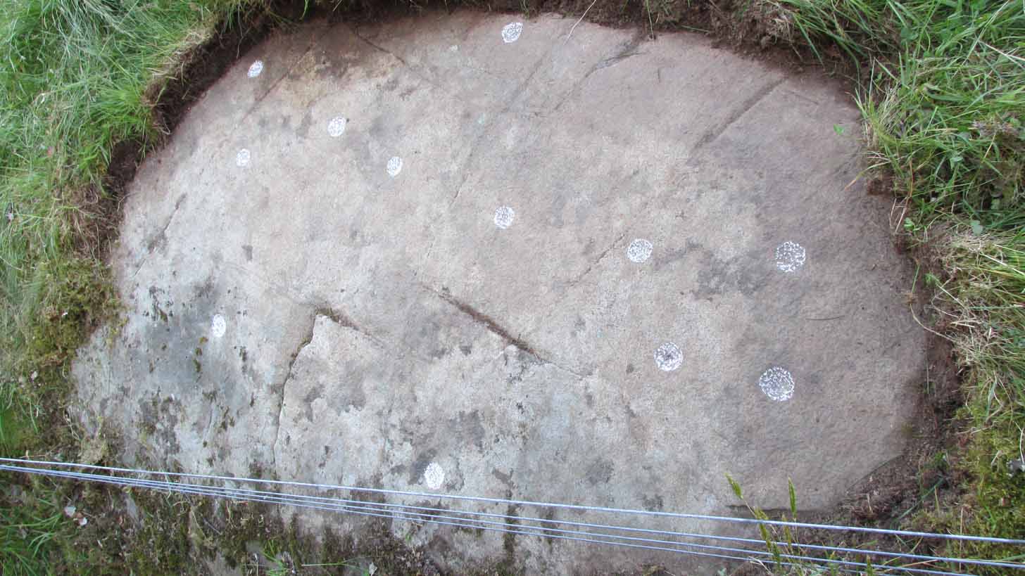
This is a most curious design, sitting way up near the top of this unnamed hill on its western face. It’s curious as there are number of odd elongated cup-marks which, to me at least, should be described as footprints. We find such designs on a few carvings (such as the one at Dunadd, and St. Columba’s Stone, etc), but they’re pretty rare. The best can be found on the Cochno Stone a few miles north of Glasgow, with additional toes on the design… but that’s for another site profile – and an essay, perhaps, should I ever get round to writing it! Anyhow…
It was first described, albeit briefly, by a Mr Comrie in 1972, who told us that,
“On a south-west facing slope of Buchanty Hill at 950ft is a boulder measuring 1.60m x 1.40m with 22 cups and 11 dumb-bells, 6 of which are distorted by a fault of quartz in the stone.”
Central “footprints”“Footprints” & cup-marks
But his description of what he saw as eleven “dumb-bells” is somewhat extravagant. Six, perhaps seven would seem the more probable. I was hoping to find that the Scottish Rock Art Project doods might have spent some of their million quid in doing a computer enhancement of this carving in order to confirm it one way or the other, but this was one of hundreds that they never looked at. Very poor… (and they only described two so-called dumb-bells here!) The only other mention I’ve found of the place is in Finlayson’s (2010) fine survey of local megaliths, but only in passing.
The dumb-bells or “footprints” on this carving are small: fairy footprints, one might say. The main ones are seen near the middle of the stone on its flat smooth surface. Another—perhaps two—occur along a curious geological cut that runs in a straight line, north-south (roughly) over the rock. This curious line has a series of deeply cut elements, mainly cup-marks, which give the impression of being enhanced or worked upon in much more recent centuries, looking almost as if they possessed some utilitarian function. They’re most odd and are certainly much younger than the very worn cup-marks that are scattered across the stone in no particular order. One of them seems to have a very faint ring around it. You can just make it out in one of the photos.
Looking southeastA nice close-up
So we’re looking at a multi-period carving done (probably) over several centuries. Some of the cup-marks are barely visible unless the light is just right. On my first visit here, the day was grey and overcast and some elements of the design were all but invisible; but on my second visit, on a beautiful evening, when wetting the rock, it shone out in all its splendour…. Well – as good as could be expected considering it may be five thousand years old! But the footprints are the stand-out features of the design.
In a lengthy essay on this motif that’s found on numerous European petroglyphs, Miroslav Verner (1973) points out several traditional and theoretical meanings ascribed to the symbol, which may be relevant to the stone here. The footprints may mark the rock as a pilgrimage site; or a representation of the location of a theophany, or genius loci. In some places it can be a signature of the so-called artist; or a symbol of victory; and even a symbol which possesses the power to cure fevers and other ailments. This latter tradition was known to have been practiced at the mightily impressive Blarnaboard (3) carving near Aberfoyle.
Another important feature of this carving its position in the landscape: more than a thousand feet above sea level, you sit here and the vista ahead of you reaches far far away into the distance from east to south to west. The skies above and around it are open and seemingly endless from here. It’s impressive and, most likely, these attributes are mythically significant to its meaning. Have a look at the place: take a day out and sit here for a while and get your own impression of the place. You’ll like it…
The best/easiest way to approach this and the Rivock carvings as a whole is to reach the Silsden Road that curves round the southern edge of Rombalds Moor (whether it’s via East Morton, Riddlesden, Keighley or Silsden) and keep your eyes peeled for the singular large windmill. About 200 yards east of this is a small parking spot, big enough for a half-dozen vehicles. From here walk 450 yards east along the road till you hit the dirt-track/footpath up towards the moor. Follow the track up for about 400 yards and you’ll see the crags a half-mile ahead of you. Get up there to the Wondjina Stone and follow the walling east for about 175 yards where you’ll see a track-cum-clearing in the woods. Walk along and the first large stone on your left is what you’re after.
Archaeology & History
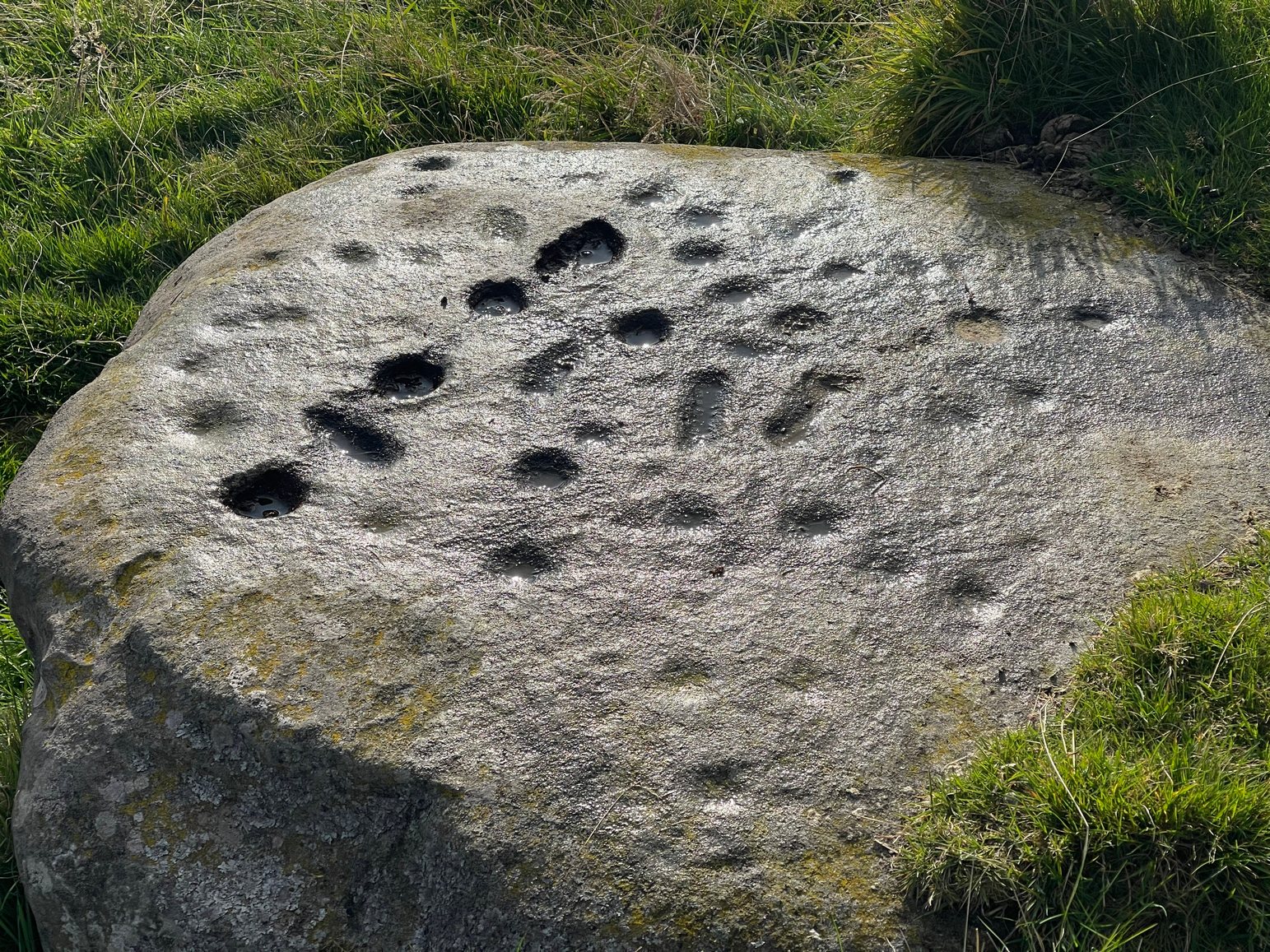
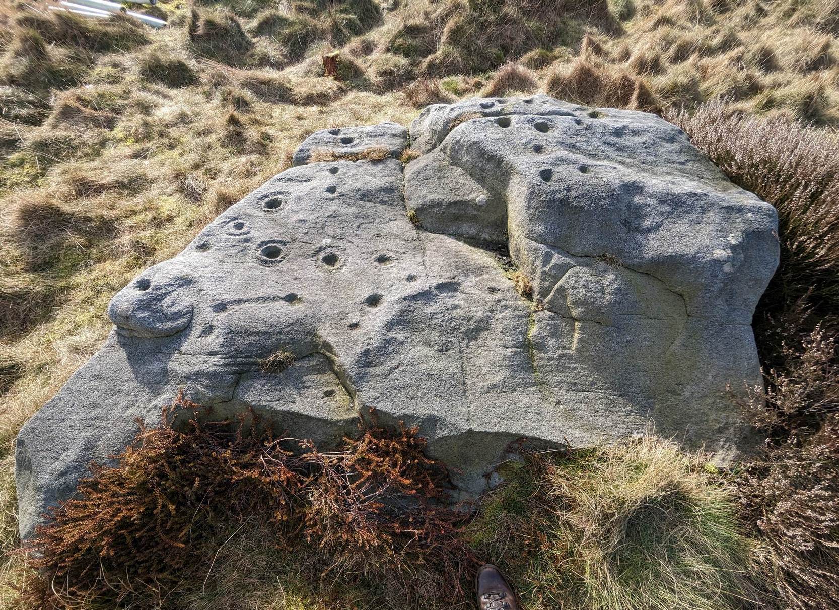
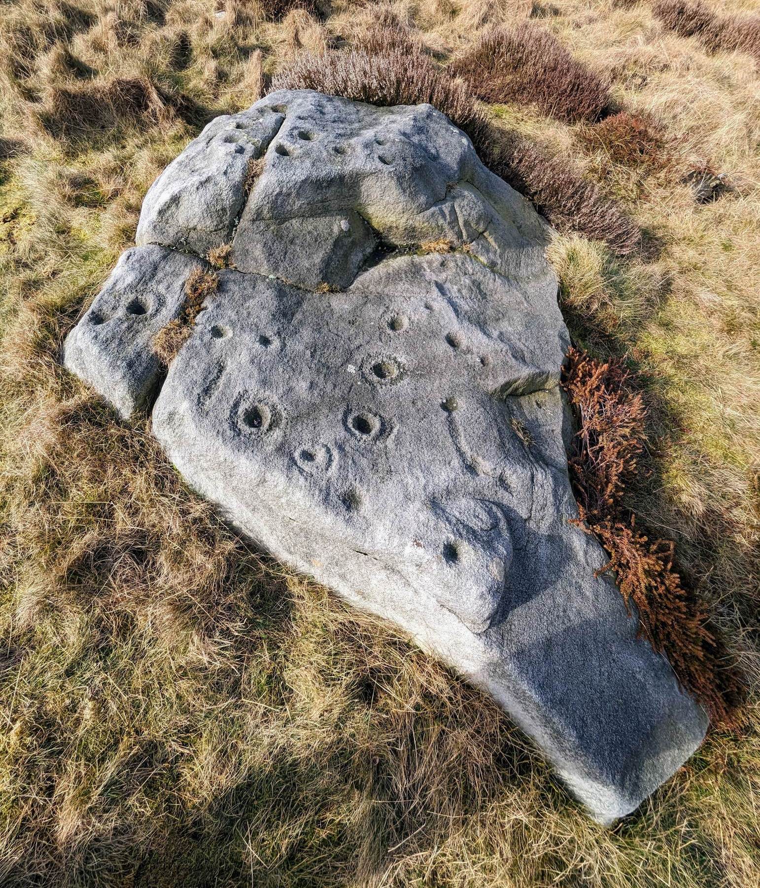
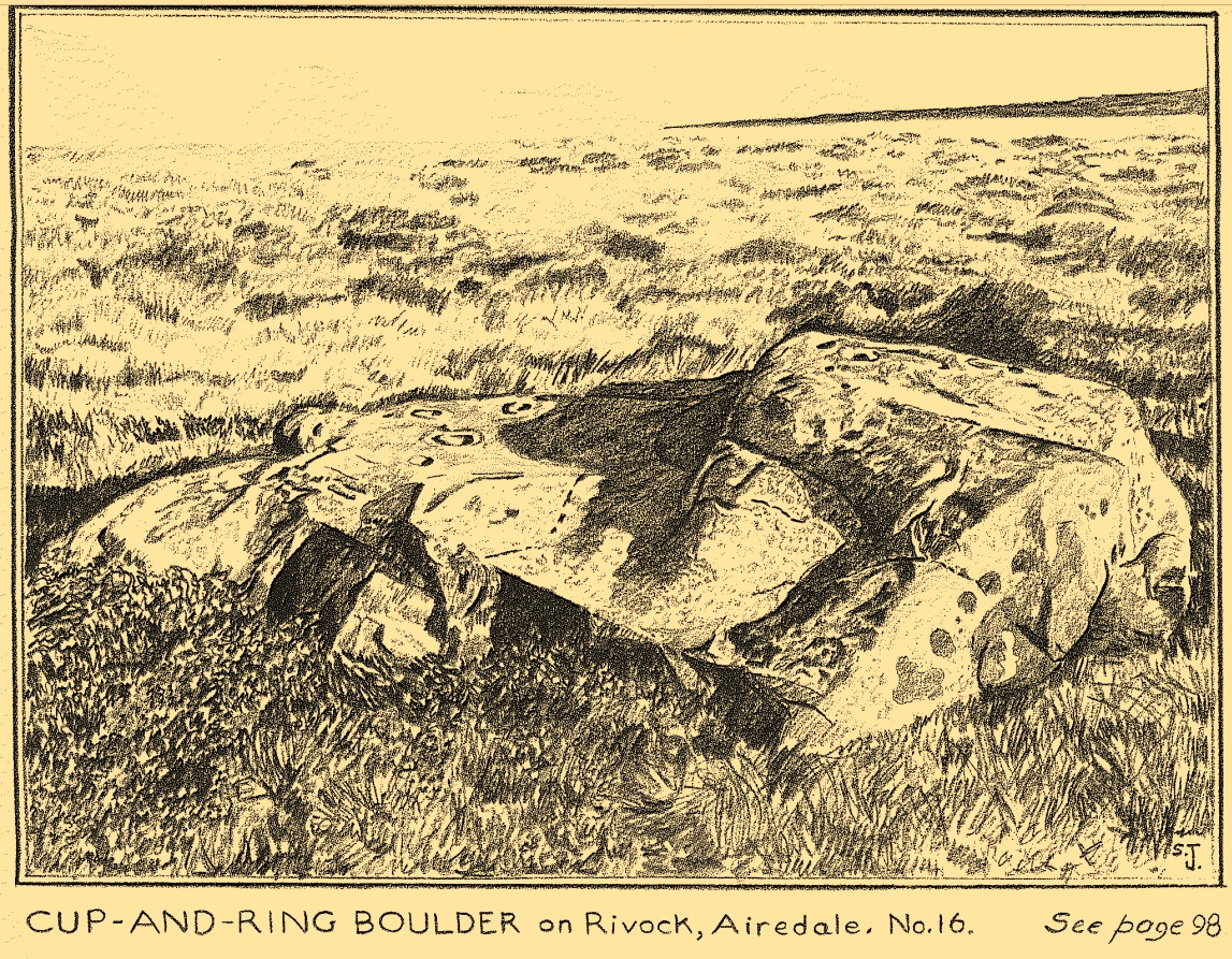
I first visited this carving in my teenage years in the 1970s, before the intrusive so-called “private” forest covered this landscape and when its petroglyphic compatriots were easier to find. Thankfully this one’s still pretty accessible and possesses a damn good clear design. It was rediscovered in the 1960s by Stuart Feather and his gang, zigzagging their way across the open moors, pulling back the heather to see what they might find. His description of it told how the stone,
“has two roughly level areas, one 18ins and the other 2 feet above ground level. Both (levels) have several well-preserved cup-and-ring markings on them. There are eight single cup-and-rings and 18 cups, two of the latter being joined by a clear channel seven inches long and 1½ inches wide. Nearly all the markings are unusually well preserved and the pocking marks are very clear.”
Note the line running down
He also had “the impression that all the markings on this stone and possibly one other similar stone in the Rivock area have been carved by the same hand, as all the symbols are nearly identical in in type, size and execution.” (this other carving he’s referring to seems to be one about 170 yards to the north, where occasionally “offerings” have been found)
The design from E-W
When John Hedges (1986) and his team checked the stone out he could only make out “seven cups with single rings, twenty two other cups”; whilst the ever descriptive Boughey & Vickerman (2003) saw “twenty-nine cups, eight with single rings.” Eight cup-and-rings is what most people see when the light’s right. There’s also a long, bent carved line on the lower level of the rock, running from near the middle of the stone out to the very edge. It seems to be man-made (although I may be wrong) – and I draw attention to it as this same feature exists on at least three of the other large and very ornamental cup-and-rings hereby within 300 yards of each other – and on these other carvings the long “line” is definitely artificial. Tis an intriguing characteristic…
Stuart Feather’s old sketch
When visiting this petroglyph you’ll notice how some of the carved elements on top of the stone are more eroded than those on the lower section. This is due to the fact that the lower section was only revealed by Feather and his team in the mid-20th century, after it had been covered in soil for countless centuries. As a result you can still see the peck-marks left by the implements that were used to make the carving, perhaps 5000 years ago!
The name of the stone was inspired by a local lady who saw an astronomical function in the design (I quite like it as well). Examples of petroglyphs representing myths of heavenly bodies have been described first-hand in some tribal cultures and, nowadays, even a number of archaeologists are making allusions about potential celestial features in some carvings in the British Isles. That doesn’t mean to say that it’s correct, but the idea’s far from unreasonable…
Anyhow – check this one out when you’re next up here. You’ll like it!
References:
Bennett, Paul, “The Prehistoric Rock Art and Megalithic Remains of Rivock & District (parts 1 & 2),” in Earth, 3-4, 1986.
Boughey, Keith & Vickerman, E.A., Prehistoric Rock Art of the West Riding, WYAS 2003.
Deacon, Vivien, The Rock Art Landscapes of Rombalds Moor, West Yorkshire, ArchaeoPress: Oxford 2020.
Feather, Stuart, “Mid-Wharfedale Cup-and-Ring Markings – no.16 – Rivock,” in Cartwright Hall Archaeology Group Bulletin, volume 8, no.10, 1963.
Hedges, John (ed.), The Carved Rocks on Rombalds Moor, WYMCC: Wakefield 1986.
Morris, Ronald W.B., “The Prehistoric Rock Art of Great Britain: A Survey of All Sites Bearing Motifs more Complex than Simple Cup-marks,” in Proceedings of the Prehistoric Society, volume 55, 1989.
Acknowledgments: Huge thanks to Collette Walsh for use of her photos.
Out of Aberfeldy, take the A826 road as if you’re going up Glen Cochill. Not far up, just where the housing of Aberfeldy itself ends and the green fields open up either side of you, keep on the road for a half-mile where you meet a small copse of trees on your left, with a dirt-track that runs down the slope. Go down here and follow the slightly meandering track for 0.8 miles (1.3km), a short distance past the Ursa Major Stone where the track splits. Take the track to the left and there, less than 100 yards on you’ll hit a large boulder on your left. That’s it!
Archaeology & History
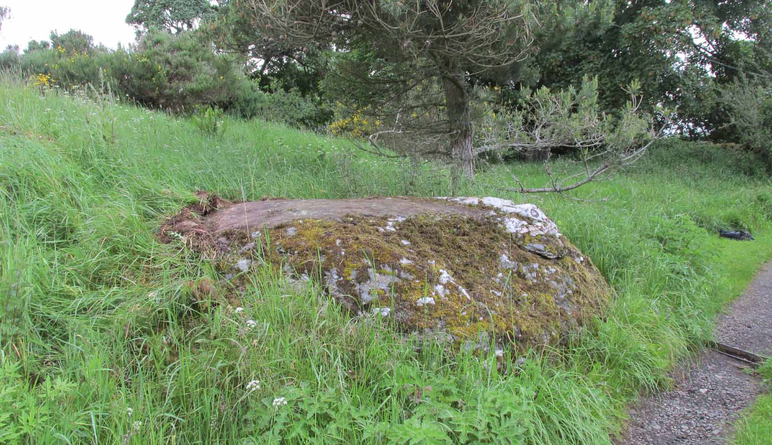
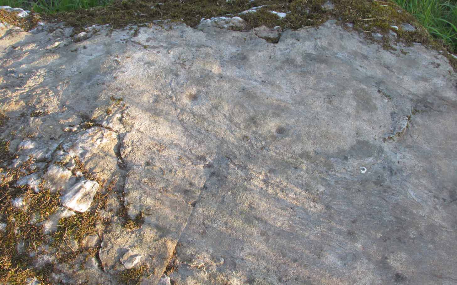
Not previously recorded, this simple cup-marked stone will probably only be of interest to petroglyph aficionados, or those folk who are into ‘energies’ at sites. This latter aspect is due entirely to the carving being etched onto a huge rock, much of which is composed of quartz—which isn’t too unusual in this part of the world. But that aside…
Looking down at the cupsThe cupmarks highlighted
It is one in a group of carvings within a few hundred yards of each other, with its nearest neighbour 20 yards to the north. That one’s covered in cups—but on this large Quartz Stone, only two of them exist, on the top near the centre. Just a couple of inches across and half-an-inch deep, they’re pretty clear once you see them. The raised piece of ground behind the stone is artificial and has variously been described by antiquarians and archaeologist alike, as either a prehistoric dun, or a stone circle. Whatever it may be, some of it is certainly man-made. Check it out – and mebbe ask the friendly fat fella who lives nearby and what he thinks.
Out of Aberfeldy, take the A826 road as if you’re going up Glen Cochill. Not far up, just where the housing of Aberfeldy itself ends and the green fields open up either side of you, keep on the road for a half-mile where you meet a small copse of trees on your left, with a dirt-track that runs down the slope. Go down the track, bending to the right, then the left and then on for a quarter of a mile until the lines of trees appear either side of you. Barely 200 yards along, the track swerves slowly to your right, and the field above you slopes uphill. Keep your eyes peeled at the fencing on your right and you’ll see a stone sloping towards you right by the fence with faint cup-marks on it. You’ll find it!
Archaeology & History
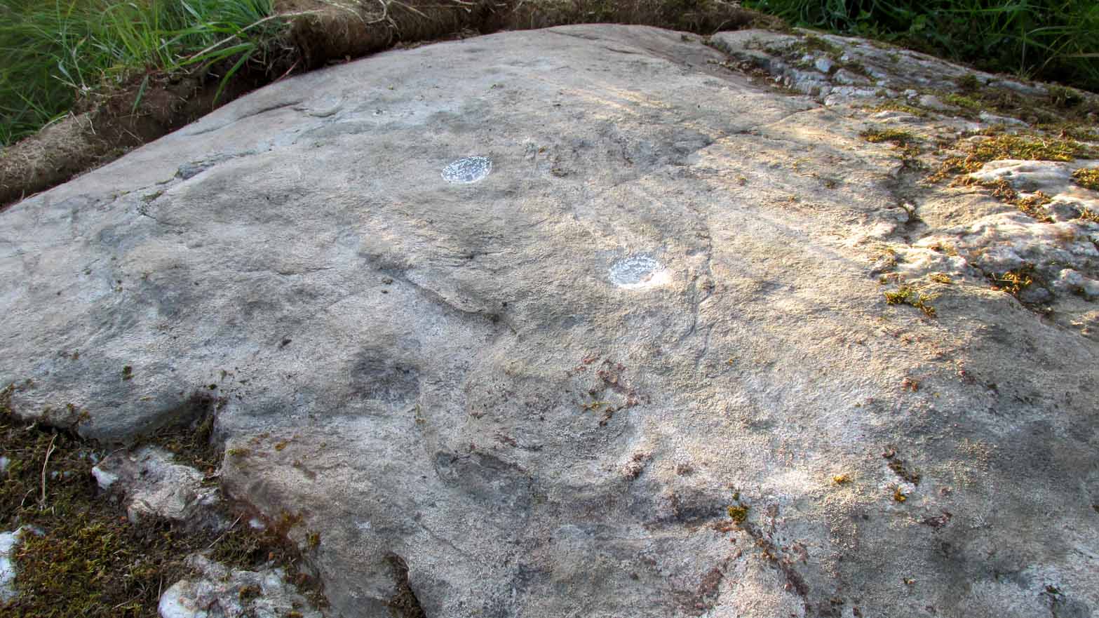
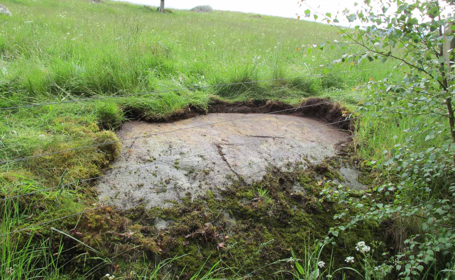
A truly fascinating cup-marked stone recently uncovered by Paul Hornby on another one of our TNA meanderings. Fascinating because of the curious arrangement of the cups on the stone. Often, cup-marked stones have little to interest the causal visitor – but this one’s different. As can be seen quite clearly, the cups are arranged in the shape of the constellation of the Great Bear, or Ursa Major – albeit with an extra ‘star’ in this design. But it’s damn close! In all likelihood (he says with his sceptical head on 😉 ), the design is fortuitous when it comes to the Ursa Major. I know from many years experience how easy it is to see meaningful shapes and designs in the almost entirely abstract British petroglyphs, but the design is very close to the constellation we all got to know when we were kids.
Looking along the stoneGazing down at Ursa Major
The stone itself slopes upwards at an angle of about 60º, before starting to level out as it rises. All of the cup-marks have been pecked onto this sloping surface (the vast majority of carvings are found on top of stones). Altogether, at least twelve faint and shallow cups were exposed when we looked at it—measuring the usual inch to inch-and-half across—but it is likely that more of them are hidden beneath the turf at the top of the stone. We could discern no rings or other features in the design.
This is just one carving amidst a good cluster of petroglyphs within a few hundred yards of each other (the Quartz Stone being one of the nearest) that are well worth checking out if you like your rock art. It may also be of interest to astronomy students, or those exploring archaeo-astronomy.
References:
Yellowlees, Sonia, Cupmarked Stones in Strathtay, RCHAMS 2004.
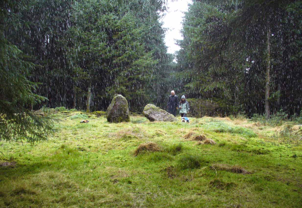
Of the 2 ways to reach here: one via the Crow Road, up to Waterhead Farm and then meandering through the forest—we took the other one! From the car park at the western end of Carron Reservoir, take the track into the forest. Stick to the track closest to the loch until, after crossing the small river bridge, veer right at the next junction 200 yards on. Another 600 yards (0.5km) along, take the right turn and walk all along this track to the very end. From here, take your feet down into the opening along the small burn and stick to this gap in the trees for 100 yards or so, where the gap in the trees veers left. Keep walking for another 200 yards.
Archaeology & History
These stones might take some finding, but they’re worth the effort if you like your megaliths. When Nina, Paul and I visited them yesterday, the meander turned into what have become known as Barmy Bennett Bimbles as we ventured off-path and into the forest, wading through marshland and getting our eyes poked out in the dense trees! And then the snow came. Twas gorgeous to be honest…
Machar Stones, looking SE
Machar Stones, looking west
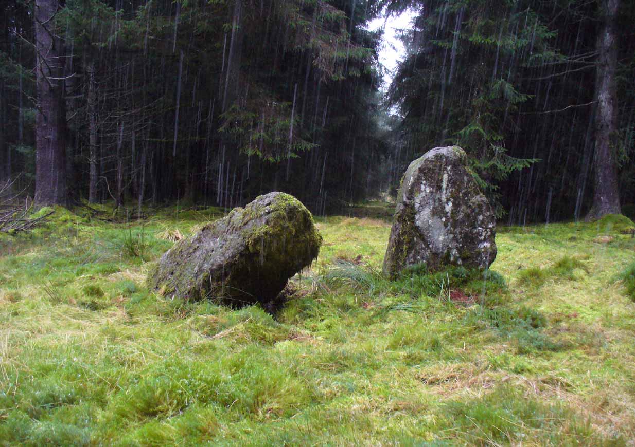
Probably neolithic in origin, the Machar Stones are set upon an elevated rise above the confluence of the Bin Burn and the River Carron on what seems to be an enhanced artificial platform, akin to those which some stone circles and ring cairns are mounted upon. Around the edges of the stones themselves, the earth has been dug into at some point in the past, as evidenced by the distinct oval dip in the ground surrounding the stones; although I can find no antiquarian accounts describing such a dig. There is the possibility that these stones may once have marked the site of a prehistoric tomb.
Once you walk ten yards away from the stones in any direction, you begin to walk downhill. Sadly the trees presently obscure any view from the stones, completely silencing the panorama that quite intentionally awoke from here in centuries gone by, disabling any immediate visual landscape analysis or geomancy. The proximity of the two rivers was probably relevant in the construction of the stones; as may be the ridge between the Little and Meikle Bin to the southeast.
First described in Nimmo’s Stirlingshire (1817) as “a druidical remain…in the parish of Fintry, about the middle of the moor towards Campsie and northwest of the Meikle Bin”, another early account of these megaliths was in H.G. Smith’s (1896) work on the parish of Strathendrick, before the imposition of the modern ‘forest’ occurred and the views from the stones were unrestricted. After describing their geographical position, he told:
“On a comparatively level part of the muirland between the two rivers and under Meikle Bin, there are two old standing stones known locally as the Machar Stones, this name being derived from the Gaelic magh, a plain. The more northerly stones measures 8 feet in height, and the other is 5 feet 7 inches high. Little…is known of the origin of these standing stones… They were apparently in some way connected with the religious worship of the prehistoric inhabitants of the land. The general uniform direction in which they point, which is to the north of east, looking as nearly as possible to the quarter of sunrise at the summer solstice, seems to point to their having been erected by a race of sun worshippers.”
Machar Stones, looking NW
Around the same time, A.F. Hutchison (1893) gave a lecture on these and other Stirlingshire megaliths, giving slight variants on the heights of the monoliths, adding that “the two stones are standing in a line pointing to 220°.” Sadly, even the great authorities of Aubrey Burl (1993) and Alexander Thom (1990), in their respective tomes on the subject, were unable to define any astronomical alignments here. Hutchison puzzled about the seeming artificiality of the platform upon which the stones appear to have been set, though wrote how “geological authority pronounces it to be a quite natural formation.”
As to the name of the site, William Grant (1963) ascribes the word ‘Machar’ and its variants to mean “a stretch of low-lying land adjacent to the sand” or “low-lying fertile plain”—which doesn’t seem relevant here, unless it was so named by people living on the higher grounds. It seems odd… As does the alignment of the stones. When Nina Harris stood between the stones with a compass to work out the cardinal points, the stone that was leaning was due north of the upright stone. When she walked several yards away from them, the compass deviated and we were given a more northeast-southwest alignment from stone to stone. This isn’t too unusual as we find similar magnetic anomalies at other megalithic sites in Britain (see Devereux 1989), due to a variety of geophysical ingredients.
Royal Commission 1954 photo
Not that your bog standard archaeo-tomes ever mention magnetic anomalies, as basic physics is too complex a subject for your standard archaeo-types! Instead however, we just get the usual measurements and data-sets, much as the Royal Commission (1963) lads gave us after their visit here in 1954—but at least there was no forest when they came here! They were fortunate. “These two stones,” they told us,
“stand on a slight eminence in open moorland, half a mile ENE of Waterhead farmhouse and at an elevation of 850ft… Described by Nimmo’s editor as “a Druidical remain”, they have also been nown as the Machar Stones. The more northerly stone, a four-sided pillar of irregular section, has fallen almost prostrate and its whole length, 7ft 6in, is revealed. At the centre it measures 3ft in width by 2ft 6in in breadth. The other stone stands 4ft 6in further S. It is a slab…standing to a height of 5ft and measuring about 2ft in thickness. Its width is 2ft 8in at ground level, 3ft 8in at a point 2ft above this, and 2ft at the top.”
They posit the idea that the reason the taller stone is leaning at such an angle was due to there being a prehistoric cist nearby which had been ‘excavated’ by peoples unknown, who then took it upon themselves to explore the Machar Stones with similar venture.
The ‘cup-marked’ stone
In recent years it has been said that there are cup-markings on the leaning stone, seven of them apparently. When we visited yesterday they were difficult to make out. There were a number of ‘cups’ on the stone, but these were debatable and seemed more the result of conglomerate disintegration than man-made. A couple of them were perhaps ‘possibles’. However, the light was poor and I’d prefer another visit before making my mind up!
The Machar Stones are quite evocative megaliths, despite their lack of grandeur. Maybe it was the snow. Maybe it was the trees. Maybe it was me. Or probably a mix of all three and more; but this had a real feel to the place. Well hidden, miles from human touch or visits, awaiting just the occasional visitor—and in this weather (of floods, downpours, cold and snow) saturated humans would be the only sorts of crazy people whose spirits would risk getting completely lost to find them. And my god were they worth the effort! Paul, Nina and I thought so anyway!
References:
Burl, Aubrey, From Carnac to Callanish, Yale University Press 1993.
Devereux, Paul, Places of Power, Blandford: London 1990.
Feachem, Richard, Guide to Prehistoric Scotland, Batsford: London 1977.
Grant, William (ed.), Scottish National Dictionary– volume 6, SNDA: Edinburgh 1963.
Royal Commission on the Ancient & Historical Monuments Scotland, Stirlingshire – volume 1, HMSO: Edinburgh 1963.
Royal Commission on the Ancient & Historical Monuments of Scotland, Archaeological Sites and Monuments of Stirling District, Central Region, Society of Antiquaries of Scotland 1979.
Thom, A., Thom, A.S. & Burl, Aubrey, Stone Rows and Standing Stones – 2 volumes, BAR: Oxford 1990.
Acknowledgements: Huge thanks to Nina Harris and Paul Hornby for their endurance and endeavor in locating these great old stones, in attendance with the great rain, snow and deep muddy bogs!
You can either find your way to Duntreath Castle on the western edges of Strathblane and walk SW straight up the steep grassy slope next to the wooded Dumgoyach Hill; or… From Carbeth, north along the A809, turn right up the B821 Ballachalairy Yett road for 1km and park where the path of the West Highland Way runs onto the hills. Follow this path for nearly ½-mile and where the path splits, bear left. Keep walking downhill for a few hundred yards, then go off-track towards the copse of trees. Climb over the gate and onto the grassy plain between this copse and the huge rounded Dumgoyach Hill. The stones are very close indeed…
Archaeology & History
This is a truly stunning site – not as much for the megaliths that are here, but for the setting in which they’re held. “Magnificent” is the word that rolled out of my mouth a number of times; whilst respected activist and ‘Organic Scotland’ creator Nina Harris said, quite accurately, “it’s Caras Galadhon in Lothlorien!” (or words to that effect) – and she hit the nail much better than I did!
Royal Commission 1963 sketch
Dumgoyach Stones (by Nina Harris)
A short line of large standing stones remains here, both upright and leaning, running NE-SW for 7 yards: seemingly a part of some other much larger monument in times long past—although very little else remains. The stones are set upon a rise of land, quite deliberately in front of Dumgoyach Hill (or Lothlorien, as Nina called it) almost as a temple or site of reverence. You’ve gotta see it to appreciate what I’m saying! Like some gigantic tree-covered Silbury Hill, the standing stones on this ridge possess an undoubted geomantic relationship with this rounded pyramid, all but lost in the sleep of local myths and land. A few yards away from the line of stones there is a slight rise in the land, seemingly giving weight to the idea that something else was living here: an architectural feature that Aubrey Burl (1993) thinks might have been “the facade of a chambered tomb” (neolithic in origin) and not merely a megalithic alignment. He may be right…
Close-up of the megaliths
Described briefly in J.G. Smith’s (1886) magnum opus on the Strathblane parish, antiquarian accounts of this impressive site seem curiously rare. One of the earliest recognised accounts was done by the Royal Commission (1963) lads who measured the site up with their usual diligence. Although getting the alignment of the stones wrong, the rest of their survey seems pretty accurate. They told that,
“There are five standing stones (A-E) arranged in a straight line… Three of the stones (A, B and C) are earthfast, while the other two (D and E) are recumbent. Stone A is of irregular shape and leans steeply towards the N. The exposed portion measures 4ft in height, 2ft 6in in breadth and 1ft 2in in thickness. Stone B stands upright, 6ft NE of A. It is a pillar of roughly rectangular section with an irregularly pointed top, and measures 5ft in height by about 2ft 6in in thickness. Stone C, also irregular in shape, 11ft 6in NE of B, is inclined so steeply to the NNE that it is almost recumbent. It measures 4ft 4in in height, 2ft 6in in breadth and 1ft in thickness. The remaining two stones lie on the ground between B and C. Stone D measures 5ft 5in in length, 3ft in breadth and 1ft 6in in thickness while stone E, which rests partly on D, measures 7ft 10in in length, 3ft 9in in breadth and 3ft in thickness.”
Aubrey Burl’s (1993) description of the site—which he called Blanefield—is another good synopsis of what is known historically and astronomically about the site. Assessing them in his detailed work on megalithic alignments, he said that,
“At Blanefield near Strathblane in Stirling a big stone, its longer sides aligned east-west, stands at an angle amongst a southwest-northeast line of four others, fallen, of which one just off the line seems to have been added this century. The setting has been presumed a collapsed four-stone row. Known also as Duntreath and Dumgoyach, the setting is slightly concave.
“‘This ruinous alignment indicates notches to the northeast and these show approximately the midsummer rising sun.’ ‘The standing stone has a flat face exactly aligned on a hill notch to the east,’ quite neatly in line with the equinoctial sunrises. These astronomical analyses would seem to confirm that Blanefield was undoubtedly a row set up by prehistoric observers to record two important solar events.
“Excavation in 1972 discovered signs of burning, flints and charcoal that yielded a C-14 assay of 2860±270 BC (GX-2781), c. 3650 BC, a time in the Middle Neolithic when chambered tombs were still in vogue, but an extremely early date for any stone row. This, coupled with Blanefield’s isolated position for a row in central Scotland, raises doubts about its origins.
“It is a lonely megalithic line, those nearest to it being over forty miles (64km) to the west in Argyll. Straddling a ridge overlooking the Blane Water it is arguable that the stones are relics of the crescent facade of a Clyde chambered long cairn with an entrance facing the southeast….”
Dumgoyach Stones, with Dumgoyne to the North
However, there was once another stone row close by, known as the old Stones of Mugdock. Burl then cites the proximity of four nearby neolithic long cairns not too far away, with the Auchneck tomb just 3½ miles (5.6km) to the west; although it seems that Nina Harris may have discovered another one, much closer still.
Folklore
Local legend reputes that King Arthur was up and about in this part of the world, fighting in a battle nearby. And in J.G. Smith’s (1886) excellent work on the parish of Strathblane, he told that,
“The standing stones to the south-east of Dungoyach probably mark the burial place of Cymric or Pictish warriors who fell in the bloody battle of Mugdock.”
References:
Burl, Aubrey, From Carnac to Callanish, Yale University Press 1993.
Feachem, Richard, Guide to Prehistoric Scotland, Batsford: London 1977.
Heggie, Douglas C., Megalithic Science: Ancient Mathematics and Astronomy in Northwest Europe, Thames & Hudson: London 1981.
MacKie, Euan W., Scotland: An Archaeological Guide, Faber: London 1975.
Ritchie, J.N.G., “Archaeology and Astronomy,” in Heggie, D.C., Archaeoastronomy in the Old World, Cambridge University Press 1982.
Royal Commission on the Ancient & Historical Monuments Scotland, Stirling – volume 1, HMSO: Edinburgh 1963.
Smith, John G., The Parish of Strathblane, James Maclehose: Glasgow 1886.
Thom, Alexander, Megalithic Sites in Britain, Oxford University Press 1967.
Thom, A., Thom, A.S. & Burl, Aubrey, Stone Rows and Standing Stones – volume 1, BAR: Oxford 1990.
Acknowledgements: A huge thanks to Nina Harris, of Organic Scotland, for both taking me to these stones and sharing her photos for this site profile. Cheers Nina!