Triangulation & cairn atop of Rye Loaf Hill on a truly foggy eve
Best way is to take the Settle to Kirkby Malham road: a tiny little thing running steep from Settle up and around the hills, making sure you don’t miss the turn-off to Kirkby and head down to Airton instead. About 100 yards along from the road-junction to Kirkby, there’s a small copse of trees and a gate just before it. Walk up through that and head right to the top of the nice hill a mile or so ahead of you to the north. It can be boggy, slippy and well good! A decent Barmy Bennett expedition this way lies! Get to the top of the hill and you can’t miss the cairn!
Archaeology & History
First shown on the 1771 Greenwood map, this is another intriguing little-known antiquity in our Yorkshire hills. It’s intriguing as the precise age and nature of the site doesn’t appear to have been ascertained. On top of this lovely rounded hill is not only a stunning view for many miles in all directions (unless you climb it on a very cloudy foggy day, like we did!), but the rock-pile which someone in recent years has turned into a wind-break has been taken from a much larger, and much older rock-pile on the very summit.
The cairn stands about a yard tall at the highest and measures roughly 12 yards in diameter, but the edges of the site seem to disappear further beneath the peat and vegetation on the hilltop. A section in the middle of the cairn has obviously been dug into, probably to create the stone shelter on its southern side, but it also gives the impression of having been dug into by treasure-seekers in the past — similar to the trenches found in the Snowden Crags cairn circle, the Great Skirtful of Stones and other prehistoric tombs.
The site has been marked on Ordnance Survey maps as a simple marker cairn (non-antiquated writing on the maps), but I have strong suspicions after visiting this peak that the cairn in question is a lot older than has previously been assumed. So I contacted local archaeologist Robert White and asked if he knew of any archaeological data about the cairn, but he said there was nothing that he knew. However, an additional piece of information that adds potential to the antiquity of the cairn came from the awesome pen of Harry Speight (1895) who told that,
“The original name of this eminence is Inglehow, which suggests like Ingleborough and ancient look-out post or beacon hill.”
The suffix how or howe is well-known to place-name students in northern England and beyond as a burial mound or tumulus. We must be cautious however, for as Gelling (1988) says, the word “is frequently applied to a tumulus, but it can refer to a natural hill.” But Speight’s idea that the name may have had something to do with beacons was mentioned — albeit without reference to Rye Loaf Hill, whose history and features he ignored — in Thomas Whitaker’s (1878) huge survey, where he wrote:
“In this parish was an immemorial custom, continued within the memory of many persons yet alive, of kindling fires on the tops of the surrounding hills on St. Laurence’s Eve, the 9th of August. This night was called the Kennel or Kennelk night; and the tradition of the place is, that the fires were intended as a memorial of the beacons kindled by the Saxons to alarm their countrymen on the sudden approach of the Danes.”
The parish in question that Whitaker described was Giggleswick, which is right next door to Settle, in whose parish Rye Loaf Hill lives.
On the southern edge of Rye Loaf are a couple of other archaeological place-names that need looking at. We have a couple of ‘Stone Haws’, which are probably cairns, close to which we find extensive evidence of human activity at some time in the past. But close to one of these piles of stones is another, far more fabled rock whose history appears to have long since been neglected: the Dragon Stone of Scosthrop Moor. Never heard of it? That’s not surprising…
References:
Gelling, Margaret, Signposts to the Past, Phillimore: Chichester 1988.
Smith, A.H., English Place-Name Elements – volume 1, Cambridge University Press 1956.
Speight, Harry, Tramps and Drives in the Craven Highlands, Elliot Stock: London 1895.
Whitaker, Thomas Dunham, The History and Antiquities of the Deanery of Craven in the County of York, (3rd edition) Joseph Dodgson: Leeds 1878.
Early photo of holy well site (Henry Taylor, 1906)
To get here you have to travel right to the end of the road, then walk a short distance until you hit the horrible coastal waters where there’s a natural rock arch. Just before here, on the west-facing side, is this famous holy well.
Archaeology & History
Just before this little-known sacred well is a cavity in the limestone rock which is called the Fairy Church, and a couple of hundred yards below here is another one which was known as the Fairy Chapel. This region was obviously of sacred importance to our ancestors – and should still be to those of us with ecological concerns. The waters from this well were said to cure poisons from the body. It was written about at some length in Mr Taylor’s (1906) superb survey, where he collated material from a series of other early tracts describing the well. He wrote:
“This celebrated medicinal well is said to have been used by lead miners from the time of the Romans. The patients come for a two or three days’ stay to “get the poison out of their systems.” The site is three and a half miles nearly due south from Cartmel. The water, which has a very peculiar taste, comes down from the hillside and flows into a small artificial basin or grotto. The key of the door is kept at a neighbouring farmhouse. Close to the well is an untenanted building formerly used by indigent sufferers. The wooded cliff forming ‘The Head’ is of singular beauty, overlooking the waters and sands of Morecambe Bay. On Hennet’s map of Lancashire (1828) the well is called ‘Spa Holy Well.’
“…Mr. W. O. Roper, in his Churches, Castles, and Ancient Halls of North Lancashire, writes: “One other appendage to the Priory of Cartmel should be mentioned, and that is the well known as the Holy Well. On the sea-shore, close under the towering cliffs of Humphrey Head, and almost immediately below the natural arch of rock which leads to the recess known as the Fairy Chapel, bubbles the well to which in former days the Priors journeyed in state from their neighbouring Priory, and to which in more recent times large numbers of people resorted, hoping to derive benefit from its medicinal qualities.”
“Mr. James Stockdale, in Annals of Cartmel, writes: “Near to this holy well (Humphrey Head) are two cavities in the mountain limestone rock called the ‘Fairy Church’ and the ‘Fairy Chapel,’ and about three hundred yards to the north there used to be another well, called ‘Pin Well’, into which in superstitious times it was thought indispensiable that all who sought healing by drinking the waters of the holy well should, on passing it, drop a pin; nor was this custom entirely given up till about the year 1804, when the Cartmel Commoners’ Enclosure Commissioners, on making a road to Rougham, covered up this ‘Pin Well’. I have myself long ago seen pins in this well, the offerings, no doubt, of the devotees of that day.”
“Mr. Hope, in his Holy Wells of England, says that “this is a brackish spring celebrated as a remedy for stone, gout, and cutaneous complaints. The water issues from a projecting rock of limestone, called Humphrey Head and its medicinal qualities occasion a considerable influx of company to Cartmel, Flookborough, Kent’s Bank and Grange during the summer months…”
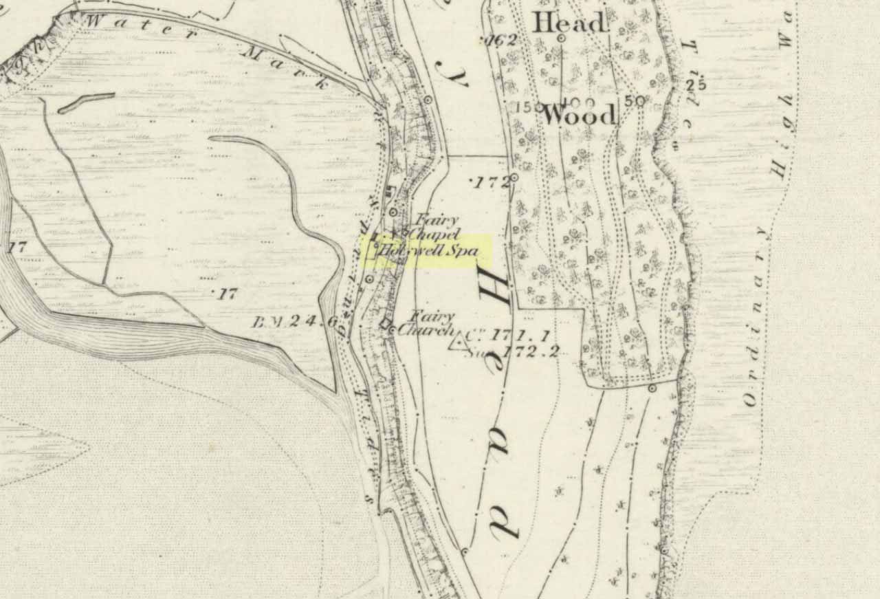
Holy Well on 1851 map
The site was clearly marked in 1851 on the first OS-map of the area as the Holywell Spa, and the attendant Fairy Chapel and Fairy Church shown as two distinctly separate places, very close by.
References:
Hope, Robert Charles, Legendary Lore of the Holy Wells of England, Elliott Stock: London 1893.
Taylor, Henry, The Ancient Crosses and Holy Wells of Lancashire, Sherratt & Hughes: Manchester 1906.
Carlie Craig is the tree- covered cliff, centre of photo
If you’re coming from Blairlogie, a half-mile west of the village, take the B998 road to the university, but turn right up the first road that runs uphill into the trees. But if you’re coming from Stirling or Bridge of Allan, keep your eyes peeled for the barely visible B998 at the crossroads and go up the hill, and along, for a good mile, below the Uni, past the factory, then up the small road on your left. Up this road go past the church another 100 yards and you’ll see the derelict ruins of Logie Kirk on your right. Right above the ruin you’ll see the tree-lined cliff immediately behind. This is the Carlie Craig!
Folklore
Carlie Craig on the 1862 map
The tree-covered Carlie Crags above the old ruined church and graveyard of Logie Kirk immediately below (thought to have been built in 1684) has long been associated with legends of old witches. Deriving its name from ‘carlin’, a witch or old woman (cailleach), the Crags were traditionally the place of heathen rites (authentic ones, not your plastic pagan types). In David Morris’ (1935) essay on the local township, he told the common story that “an elder in Logie Kirk was of the opinion that the Carla’ Craig…was haunted.” At the end of the 19th century, Morris remembered a local lady known as ‘Ailie’, who was said by many old folk to be the traditional “witch of Logie.”
“Sickly children were brought to her for her blessing. Occasionally people came from as far as Stirling on this errand. Her method of giving the blessing was to blow her breath on the child, and this was supposed to ward off evil. It was also said that anyone buried in Logie Kirkyard on the first day of May, Hallowe’en, or other days of that kind, without her blessing, would not rest in his grave…”
Another legend told that,
“around 1720 witches were believed to rendezvous with the Evil One (i.e. the devil) who would appear in the form of a large black dog.”
A lengthier account of the belief in witchcraft and animistic pre-christian rites above the crags was told by Charles Rogers (1853):
“About the second decade of last century, there lived in the parish of Logie several ill-favoured old women, to whom the reputation of witchcraft was confidently attached. They were believed to hold nocturnal dialogues and midnight revels with the Evil One, and Carlie Crag was regarded as one of their places of rendezvous. Satan, though he was believed to appear to them in various forms, was understood, in his interviews with the dreaded sisterhood, to appear most frequently in the aspect of a large shaggy dog, in which form it was alleged he had repeatedly been seen by the minister. An elder of the kirk had been returning of an evening from a shooting excursion among the hills, with a trusty musket, which he had picked up some years before on the field of Sheriffmuir, and discovering on the top of Carlie an animal realizing the description of the Satanic mastiff, resolved to try upon it the effects of a shot. He knelt down cautiously near the foot of the crag, and after ejaculating a short prayer, and slipping into his musket a silver coin, fired with trembling heart but steady aim. His victim, evidently shot dead, tumbled to the base, and the delighted and astonished elder lost no time in personally communicating to the minister the success of his wonderful adventure. Though not a little superstitious, the minister was somewhat sceptical as to the mysterious dog being really dead. He however agreed to accompany his elder next morning to the foot of the crag to inspect the carcase; but on reaching the spot, they found the remains of no shaggy dog or evil genius, but the lifeless form of the beautiful pet goat of a poor and aged woman, a much respected parishioner. The minister and elder both shed tears. The wicked dog still lived, the innocent goat had perished. The elder however took credit to himself for his good intentions and valorous intrepidity ; and the minister deemed it proper to improve the subject in his pulpit prelections on the following Sabbath. Discoursing on the subject of resistance to the Devil, he remarked, that the Evil One might assume numerous shapes and forms; that he went about as a roaring lion was declared in the Word, but he might take to himself various other aspects. He might even appear as a black colley dog.” But whatever form he may assume,” added the minister, ” he cannot be overcome or destroyed by powder and shot. There is a gun, however, that will shoot him, and it is this — it is the Bible. Shoot him then, every one of you, with this gun, and he shall be shot.”
Whether the vicar’s biblical superstitions were adopted by local people—who were so much more used to the living animism of landscape and natural cycles—is questionable. The crag is a fine site for ritual magick and its associative devil-lore probably derives from Pictish shamanistic practices, remains of which are evident across the Scottish hillls and northern England, where they survived for some considerable time…
References:
Morris, David, B., “Causewayhead a Hundred Years Ago”, in Transactions of the Stirling Natural History and Archaeological Society, 1935.
Roger, Charles, A Week at Bridge of Allan, Adam & Charles Black: Edinburgh 1853.
Watson, Angus, The Ochils – Placenames, History, Tradition, Perth & Kinross District Libraries 1995.
Legendary Stone (destroyed): OS Grid Reference – NT 058 865
Archaeology & History
Travelling along the old road between Crossford and towards Cairneyhill, on the right-hand (north) side, there was until recently a huge boulder, described by the folklorist J.E. Simpkins (1914),
“Its horizontal dimensions above ground are diagonally 18 feet by 21 feet; its vertical height above ground 5 feet… I estimate its weight at nearly 200 tons.”
The stone was proclaimed by 19th century geologists to be a glacial deposit from the upper region of the Forth (the nearest mountain region possessed of this type of stone); although our old petroglyph writer, Sir James Simpson, postulated the Witch’s Stone to be “of meteoric origin.”
But like oh so many old sites with heathen tales attached, the stone was destroyed by a local farmer on 7 February, 1972. The following interesting notes were made in a Crossford & Cairneyhill School log-book, describing its destruction:
“The local farmer blasted the “Witch’s Stone”, situated about 300m East of school at 2.30 this afternoon. Children vacated both buildings and sheltered at West End of main building. All windows were opened. Police informed that further operations of this nature will be carried out at weekend.”
A week later on February 14, all “remains of “Witch’s Stone” removed by blasting at 3pm today.”
On the other side of the road from our Witch’s Stone was another boulder, this time known as the Cadger’s Stone, said by Beveridge (1888) to have got its name,
“from the circumstance of its having formed a landmark for the ‘cadgers’, or itinerant merchants, who were wont to rest themselves and their ponies whilst they deposited for a short while their burdens on the stone.”
The earliest OS-map of the region in 1856 shows neither of these stones, but does highlight a Capel Stane, or Stone of the Horse, very close by.
Folklore
The stone was obviously of some traditional importance to local people in pre-christian times. David Beveridge (1888) described the position and creation myth of the Witch’s Stone as follows:
“On our right a singular-looking stone of blue limestone appears in a field, and is known as the Witch’s Stone, the popular legend being that a notable witch in this neighbourhood found it on the seashore, and that after she carried it some distance in her apron, the string of the latter broke, and the stone has since continued to lie in the place where it fell. “
A few years after this, the folklorist J.E. Simpkins (1914) wrote:
“The legend connected with this boulder is, that a witch wishing to bestow a valuable gift on the Pitfirrane family, resolved to present to them a cheese-press. With that view, she lifted this boulder and carried it some distance in her apron, but owing to its excessive weight the apron-strings broke and the stone fell to the ground, where it has remained ever since.”
If anyone knows anything more about this old stone, or has any old photos of the fella, please let us know!
References:
Beveridge, David, Between the Ochils and Forth, William Blackwood: Edinburgh 1888.
Simpkins, John Ewart, Examples of Printed Folk-lore Concerning Fife, with some Notes on Clackmannan and Kinross-shires, Sidgwick & Jackson: London 1914.
Standing Stone (destroyed?): OS Grid Reference – SE 282 402
Archaeology & History
Idol Rock, Adel (Simpson 1879)
Difficult to know what to think about this one. It seems to have been described just once in the latter half of the 19th century by that real Bible-thumping nutcase, Henry Simpson (1879), who gave us the only known picture of the place. Simpson said that it was, “the remains of supposed Idol Rock on the moor near Adel reformatory, under the Alwoodley Crags. About six foot high.” It is believed to have been destroyed, but having not checked the region thoroughly, it could still be there somewhere (the grid reference cited here is an approximation). Does anyone know owt else about it?
References:
Simpson, Henry T., Archaeologia Adelensis, W.H. Allen: London 1879.
Bittova journey this — but well worth it! From Broughton-in-Furness take the A595 road west, past Duddon Bridge for about another 1½ miles, turning right up the small single-track country lane beloved of city-mind drivers, up the fertile scruffy road, past Broadgate and stopping just before Cragg Hall Farm. There’s a dirt-track running up the back of Cragg Hall. Go up here and keep walking for a mile or so until, as you approach Swinside Farm and the fields open up in front of you, the stones begin to appear.
Archaeology & History
Swinside, looking east
The Swinside stone circle is Aubrey Burl’s favourite. And for good reason! Like other impressive megalithic rings of the region, the stones are large, well set, and the landscape holds the stones finely in the hills. Without the landscape here, Swinside (like Castlerigg and elsewhere) would not have such grandeur. When you sit in the ring, or walk round it, Knott Hill to the south was of obvious mythic relevance to the people who built this stone circle four or five thousand years ago. But this can be said of many of the surrounding crags. A few miles southwest we see the top of the haunted Black Combe rising into clouds, still speaking to some with spirits from animistic realms, long known to our ancestors. Following the skyline west and past the small falls of Whicham stream, whose name speaks of long past trees, we reach the near-west skyline with the cairn-looking pap of the Raven Crag, symptomatic of magickal rites calling to and beyond the circle. To the north is the symbolic ridge of Lath Rigg. Along the craggy eastern ridges from here you get the impression that you’re more in Argyll than Cumbria; and the break in the hills to the southeast reaches to the distant pinnacle of Kirkby Moor, where the midwinter sunrise emerged to tell of solar calendrical motions and the coming of the dark season to our megalithic tribes. But enough of the landscape!
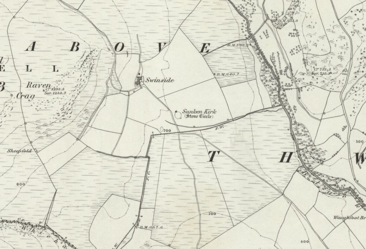
Swinside on 1867 OS-map
Although the name Swinside can be traced back to the 13th century, the local folk-name of the circle—Sunken Kirk—was mentioned for the first time as “the Chapell Suke” in Parish Registers of 1624. No earlier literary source has yet been identified, probably because of the isolation of the site and the lack of people writing about the area. Swinside stone circle is, just about, a perfect circle, give or take a foot here and there, holding the circular dome of the heavens within its domain. Yet despite its almost regal appearance, early references to the site seem scant. It seems to have been first described in William Hutchinson’s huge History of Cumberland (1794), where he told:
“In the neighbourhood of Millum, at a place called Swinside, in the estate of William Lewthwaite Esq., of Whitehaven, is a small but beautiful druidical monument; it is circular, about twenty eight yards in diameter; the stones of which it is composed are from six to eight feet high, all standing and complete. A little to the south, is another of larger dimensions, but not in so perfect a state: the neighbouring people call those places by the emphatical names of Sunken Kirks.”
A few years later, William Camden’s legendary text Britannia was edited and reprinted again, this time by Richard Gough (1806), who told:
“At Swineshead, a very high hill…is a druidical temple, which the country folk call Sunken Kirk, i.e., a church sunk into the Earth. It is nearly a circle of very large stones, pretty entire. No situation could be more agreeable to the Druids than this; mountains almost encircle it, not a tree is to be seen in the neighbourhood, nor a house, except a shepherd’s cot at the foot of a mountain surrounded by a few barren pastures. At the entrance are four large stones, two placed on each side at the distance of six feet. The largest on the left hand side is five feet six inches in height, and ten feet in circumference. Through this you enter into a circular area, 29 yards by 30. This entrance is nearly southeast. On the north or right-hand side is a huge stone of conical form, in height nearly nine feet. Opposite the entrance is another large stone which has once been erect, but is now fallen within the area: its length is eight feet. The left hand or southwest is one, in height seven feet, in circumference 11 feet nine inches. The altar probably stood in the middle, as there are some stones still to be seen, though sunk deep in the earth. The circle is nearly complete, except on the western side some stones are wanting. The largest stones are about thirty one or two in number. The outwards part of the circle upon the sloping ground is surrounded with a buttress or rude pavement of smaller stones raised about half a yard from the surface of the Earth… This monument of antiquity, when viewed within the circle, strikes you with astonishment, how the massy stones could be placed in such regular order either by human strength or mechanical power.”
Tall, northernmost stone to centreNortheast section of the ring
It seems he was impressed! Yet despite this, in the 19th century not many folk strayed this far into the western edges of Lakeland to look upon Swinside. There were occasional descriptions from travellers and antiquarians such as J.T. Blight (1843) and Edwin Waugh (1861), each speaking of the site’s visual magnitude, but it wasn’t until archaeologist C.W. Dymond came here, first in 1872 and then again in 1877, that a fuller account of the site came into being. In his essay on a “Group of Cumberland Megaliths,” he said how the stones were still in excellent condition and that,
“few of the stones seem to have been removed — probably because plenty of material for walling and road-making could be collected from the neighbouring hillside.” (Dymond 1881)
When Mr Dymond first came here he told of the remains of a rowan tree which had split one of the stones, but this has long gone. More than twenty years after the archaeologist’s first visit, he returned with R.G. Collingwood to make a more detailed evaluation of the ring. He measured and planned Swinside like it had never been done before and his ground-plan (below) is still very accurate indeed. Aubrey Burl (1999) takes up the story:
“The ring was partly excavated by Dymond, Collingwood and three men from midday Tuesday, 26 March 1901, until the close of the following evening. They dug two long, intersecting 46cm-wide trenches, NW-SE, NE-SW, across the ring with a curious zigzagging pattern of others between southeast and southwest: an investigation of some 51m² of the central area. Within the circle the trenches represented less than a thirteenth of the 642m² of the interior.
“Below the grass and turf was a thin layer of soil under which yellowish marl or ‘pinnel’ varied from 15cm to 75cm in depth, being deepest at the entrance which had been dug into earlier around 1850. Wherever it was uncovered the gravelly marl was wavily uneven, presumably the result of ploughing. The bases of the circle-stones rested on the pinnel, held firmly in their holes by small cobbles with others heavily packed around the sides. The only finds were a nut-sized lump of charcoal just northeast of the centre with others near the entrance; a minute splinter of decayed bone near the first bit of charcoal and two pieces of red stone. There were also some contemporary glass sherds and a Lancaster halfpenny dated between 1789 and 1794 lying in the uppermost turf layer.”
Dymond’s 1881 plan of Swinside
Since these early archaeological digs, Swinside has given up little else. Much like other stone circles in the British Isles, few real clues as to exactly what went on here have been forthcoming. But in the 1960s, investigations into megalithic sites made a bit of a quantum leap and some old ideas about astronomical ingredients were resurrected.
Alexander Thom’s plan of Swinside
Swinside was one of the places explored by engineer and megalith enthusiast, Alexander Thom. Thom was one of the prime figures instrumental in the resurgence of interest in megalithic sites — and his finds of megalithic astronomy and prehistoric mathematics had a lot to do with it. Although we know today that some of Thom’s work isn’t correct, his explorations and research stand him far ahead of most archaeologists who pretended to represent this area of research. He left us with the most detailed ground-plans of megalithic sites to date and, of course, showed some fascinating alignments.
Thom listed Swinside as site “L1/3” and made the most detailed and accurate ground-plan of this and 18 other megalithic rings in Cumbria. He found it to be 94 feet in diameter, with an internal area measuring 6940 square feet. The one major alignment Thom found at Swinside was of the winter solstice sunrise, lining up just on the edge of the ‘entrance’ to the circle’s southeastern side.
Folklore
Like a number of other stone circles, folklore told that you couldn’t count the stones. Janet and Colin Bord (1997) also told that people once tried to build a church here in early christian days, but once the builders went home in the evening, the Devil pulled down what they’d built during the day. A motif found at Ilkley’s Hanging Stones cup-and-ring carvings and many other prehistoric sacred sites in the country.
References:
Armstrong, A.M. et al., The Place-Names of Cumberland – volume 2, Cambridge University Press 1950.
Bord, Janet & Colin, Prehistoric Britain from the Air, Weidenfeld & Nicolson: London 1999.
Burl, Aubrey, “‘Without Sharp North…’ – Alexander Thom and the Great Stone Circle of Cumbria”, in Ruggles, Clive, Records in Stone, Cambridge University Press, 1988.
Burl, Aubrey, A Guide to the Stone Circles of Britain, Ireland and Brittany, New Haven & London 1995.
Burl, Aubrey, Great Stone Circles, Yale University Press: New York & London 1999.
Burl, Aubrey, The Stone Circles of Britain, Ireland and Brittany, Yale University Press 2000.
Dymond, C.W., “A Group of Cumberland Megaliths,” in Transactions of the Cumberland and Westmorland Antiquarian and Archaeological Society, volume 5, 1881.
Dymond, C.W., “An exploration at the Megalithic Circle called Sunken Kirk at Swinside, in the Parish of Millom, Cumberland,” in Transactions of the Cumberland and Westmorland Antiquarian and Archaeological Society, New Series volume 2, 1902.
Gough, Richard (ed.), Camden’s Britannia, J. Nichols and Son: London 1806.
Hutchinson, William, The History of the County of Cumberland – volume 1, F. Jollie: Carlisle 1794.
Seton, Ray, The Reason for the Stone Circles in Cumbria, R. Seton: Morecambe 1995.
Thom, Alexander, Megalithic Sites in Britain, Oxford University Press 1967.
Thom, A., Thom, A.S. & Burl, H.A.W., Megalithic Rings, BAR: Oxford 1980.
Waterhouse, John, The Stone Circles of Cumbria, Phillimore: Chichester 1985.
Waugh, Edwin, Seaside Lakes and Mountains of Cumberland, Alexander Ireland: Manchester 1861.
ACKNOWLEDGEMENTS:
Huge thanks to Brian Else for his photos. And to Paul and Tricia for taking us here, in awesome downpour weather!
Take the same directions as if you’re visiting the Eastwoods Cross base and cup-marked stone, but at Eastwoods Farm itself, walk downhill following the field-wall, past the large house, then through the first gate you come to. (it’s got a ‘private’ sign on it and has some handy bulls in the field – but ask at the house and the folks there are friendly) Following the footpath along the top of the field, cross the small stream, then head across the next field to the gap in the wall. You’re here!
Archaeology & History
Boughey & Vickerman’s sketch
One of a cluster of cup-and-ring stones around the Bryan’s Wood and Eastwoods area, this carving is well worth a visit, but can be covered in shit and muck as the bulls pass through the gap here on their daily amble. If the daylight isn’t good here, it can be difficult to see the carving – and when we visited the place the other day, the cloud was low and the heavens were ready to open, so our luck was out for a change! There are a number of cup-and-rings plus a double-ring, fading their ways around the more defined cup-markings. The stone appears to have been found in the 1990s, but records of it are scant. Boughey & Vickerman (2003) fail to tell the origin of the name, nor when or who rediscovered the site. Their description of the carving tells simply:
“Large flat smooth rock sloping slightly to E. Thirteen possible cups, one with partial double ring and four with partial single-rings; three ringed cups have grooves leading from them.”
Several other excellent cup-and-ring carvings can be found around here. The hugely impressive Morphing Stone and a prehistoric lightning-carving can be found three fields away to the south, past the trees on the other side of the stream.
Folklore
Close-up of the stone
The title of ‘fertility stone’ seems a modern one, although word has it that it relates to Beltane fertility rites. However, I can find no documentary information relating to this, and the people at Eastwoods Farm and adjacent house know nothing to account for it.
References:
Boughey, Keith & Vickerman, E.A., Prehistoric Rock Art of the West Riding, WYAS 2003.
From Mytholmroyd, go up the Cragg Vale Road, then 2 miles up take the road steep on your right down and round St. John’s Church, then keep going along the road up to Withens. About a mile up, a road turns sharply right. Go up here for a few hundred yards, past the trees, and 100 yards on the road splits in a ‘V’. Stop here. Go into the field on your left which slopes downhill and less than 100 yards down you’ll see the large long stone laid in the grass. That’s it!
Archaeology & History
The fallen stone, with Teddy! (image courtesy ‘QDanT’)
Included in the Addenda of The Old Stones of Elmet (p.222), here is a recumbent monolith more than 8 feet long and 6 feet across which really needs to be resurrected as it would be an impressive sight! Found halfway up Withens Clough, a local land-owner told me it was one in a row of several such stones, though no trace of the others can be found. Found in the appropriately called Standing Stone Fields, it was last shown on the 1850 OS-map, as the attached illustration shows and is positioned just above the “S” of the smaller highlighted “standing stone”, just where the little blob is! The small valley to its immediate west is called Rudstoop, from which I give the stone its name.
A description of the site is given in F.A. Leyland’s scarce commentary on the History of Halifax (c.1867), where he wrote:
“Standing Stone Fields: Not far distant from Hill Top, in this township (Erringden), there is a rough piece of ground known by this name. It is situated on the slope of the same hill as the remain last described and commands a view of the northern side of Sowerby, with the outlines and rocks of Langfield and the Withens. The locality was anciently the site of a number of upright single stones: most of these have been broken up and used in the construction of the adjoining fences. But one, the last of the series, which the quarrying operations on the spot respected during the whole time they were carried on, was undermined and overthrown a few years ago, by a number of mischievous boys. The rock is a slab of millstone grit, measuring upwards of 9 feet in length, 7 feet 8 inches in width, at the base, and 4 feet 9 inches at the top: at the latter point it is 9 inches thick, and is 1 foot 6 thick at the base. The remain has, originally, been pyramidal in form, but the apex has been either broken off by violence or reduced to its present dimensions by decay.”
An impression of the land here indicates the other, lost monoliths, were in a row which headed east from here, towards the cup-and ring-marked ‘Upper Lumb Stone’. There is also the possibility that these monoliths were aligned with the enigmatic Two Lads cairns less than a mile SW of here.
Well worth checking out!
References:
Bennett, Paul, The Old Stones of Elmet, Capall Bann: Milveton 2001.
Leyland, F.A., The History and Antiquities of the Parish of Halifax, by the Reverend John Watson, M.A., R.Leyland: Halifax n.d. (c.1867)
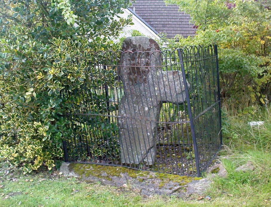
From Aberfeldy, take the B846 road over the river bridge, past Weem, a couple of miles down the valley until you see the small road on the right which leads up to the ancient hamlet of Dull. Go up and round the corner until you reach the centre of the village; and here the road turns back downhill. At this point, right by the roadside, entrapped within old railings, you’ll see the Cross of Dull.
Archaeology & History
Dull Cross behind bars
Standing more than three feet tall, the remains of this old cross with one of its extended arms broke off in previous centuries, was one of three such monuments that used to stand in the valley. This and its associates were, according to christian legend, placed as markers at an ancient centre of christian learning at Dull around the time of Adamnam (who died in Glen Lyon in 704 AD). The area was said to be an early druid college, which was later incorporated into early christian teachings. Hilary Wheater (1981) also told that in previous centuries, if anyone fell foul of the law,
“Within the boundaries of these crosses debtors, offenders or miscreants were protected from retribution. One of the crosses stands in the centre of Dull village to this day, having been used as a market cross in more recent times, and the other two, having been stolen for use as gateposts during the (19th) century, were placed in the old kirk at Weem for safety.”
References:
Stuart, John, The Sculptured Stones of Scotland, Aberdeen 1856.
Wheater, Hilary, Aberfeldy to Glenlyon, Appin Publications: Aberfeldy 1981.
Follow the same directions to get to the cup-marked stone on the slope behind Duncroisk Farm. Once here, look up the hillside and about 100 yards above you there’s the fence, and a gate in the fence. Go through that gate and walk uphill for some 20 yards where you’ll meet with a large sheet of flat sloping rock with a stream by its side. The crosses are on this rock sheet at the top left-hand side.
Archaeology & History
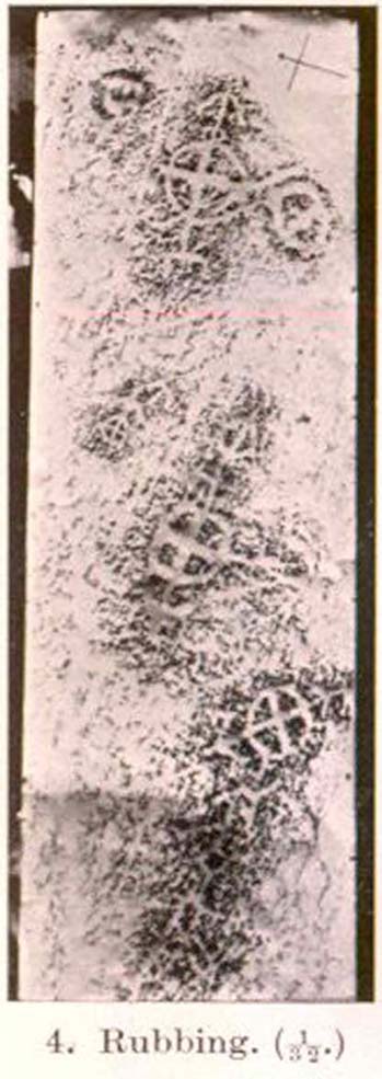
Although the stone here is pretty easy to find, the insignia carved on the rock itself can be troublesome to see. The accounts by both Cormack (1952) and Morris (1981) each recommend visiting the site around sunrise, but an hour before sunset is also profitable if you wanna see the design with any clarity. And of course, if you keep the rock-face wet (the adjacent stream is handy here) the carvings stand out even better!
Main section of carvingSolar cross & arrow?
It’s a quite superb carving in a truly superb setting, come rain, shine or mist — but for the cup-and-ring aficionado’s amongst you this one might not get y’ going, as we’re looking at a carving that was probably born of the more recent mythic period. Although there are between two and four faded cup-markings here, the principal designs do not echo the more usual neolithic and Bronze Age carvings scattering this part of Perthshire. Instead we find very worn examples of what have been variously called “solar wheels”, “Greek crosses”, Celtic crosses, etc. We also find simple carved ‘arrows’ at the ends of both natural and man-made lines in the rock; along with very distinct ‘eye’ or vulva symbolism. (Crawford 1957) Added to this is the possibility of human figurines discernible in the carving, very similar indeed to those found in Spain (Kuhn 1956) and elsewhere.
The site was first described by E.A. Cormack (1952) who wrote the following, (slightly edited) piece:
“Examination of the rough and sloping rock surface revealed an interesting group of inscribed figures, confined to an area of about 8 by 2½ feet, four of which included a cross within a circle. The figures are difficult to discern, except when thrown into relief by early morning sunlight, but are clearly demonstrated on a rubbing.
Cormack’s 1952 rubbing of the carving
“The crosses may be described in three groups:
“Group 1 — a) Near the upper edge of the rock is a cross within a circle of 8-inch diameter. The vertical axis of the cross is extended below the circle for 4 inches, resting on an ill-defined rectangular base, and upwards for 5 inches to form an arrow-head with 3-inch barbs. At the junction of the shaft of the arrow with the top of the circle is a pair of contiguous rings of about 1-inch diameter. The cross is deeply cut, to about a half-inch depth, with equal arms 4 inches long and 1 inch broad. The left arm of the cross extends beyond the circle, but this may be due to the circle being slightly excentric in relation to the cross. The lower right quadrant of the circle is marred by a natural crevice in the rock, but careful examination shows that the circle does not cut the right arm of the cross.
b) On each side of this figure is a roughly circular marking, one about 4 inches above and to the left, of 3-inch diameter, and the other 2 inches to the right, of about 5-inch diameter. In each there is an indefinite depression across the centre.
“Group 2 — a) About a foot below and to the right of Group 1 there is a boldly cut cross within a 7-inch circle. Again the vertical arm of the cross is extended above and below the circle, downwards for 5 inches to a curved arrow-head with 4-inch barbs, and upwards as an equal armed 5-inch crosslet above which is a 4-inch circle with the central axis continued through it. (The junction of this axis through the circle with the top of the small cross is slightly angled.) The main cross and circle are cut to fully half an inch in depth and one inch in breadth, but the upper part of the figure is much less distinct.
b) About 8 inches to the left of the upper part of the above figure is a very faintly incised cross within a 2½-inch circle. It is difficult to discern on the rock, but can be seen in the photograph and is very clear on the rubbing. It also appears to have an arrow-head above it.
“Group 3 — a) A foot below and to the right of Group 2 is a clearly cut cross within a 6½-inch circle. A natural cleft in the rock has been used for one axis of the cross, which lies obliquely to the others already described, and this axis terminates in an arrow-head 3 inches below the circle, and another slightly smaller arrow-head is cut 2 inches above the circle; in each case the angle formed by the arrow being towards the circle.
b) Immediately below the last cross is a curious hieroglyph not easy to make out on the rubbing, but clear in the photograph. On an 18-inch vertical axis can be seen from above downwards an arrow-head, an oblique line to the left, a faint 2-inch circle, a transverse stroke, and finally two oblique lines to the right. A natural crevice to the left of the figure rather confuses the picture.”
Ron Morris’ (1981) description wasn’t as detailed and he was initially hesitant about using the site in his rock art survey of the area, as he thought it “most likely to be early christian” in nature and period. He changed his view after talking with an associate at Bergen University, who pointed out that the symbols found here up Glen Lochay were “exactly the same as Norway’s second commonest symbol, the ‘Cross-ring’, which is contemporary with their cup-and-ring series.” Morris described the carvings here as:
“3 ‘cross-rings’ and 7 other rings, some of which have traces of crosses within them. There are also grooves, some extending from a ‘cross’-line to form an ‘arrowhead’, and one group, with ring above, rather resembles a ‘man.’ Largest ring diameter, 20cm (8in) and greatest carving depth, 1cm (½in).”
Examples of the artistic symbolism found at this ‘Duncroisk Crosses Stone’ are scattered throughout western Europe from the Bronze Age period onwards: notably at Dowth and Clonfinloch in Ireland (Brennan 1983; Coffey 1912); Jonathan’s Cave, Fife (Simpson 1867); Valcamonica, Italy (Anati 1961); and all over Norway and Sweden (Coles 2005; Gelling & Davidson 1969; Janson 1966). In more recent times we find these curious symbols etched inside the prehistoric chamber of Ty Illtud (Grinsell 1981) — but these are thought to be later additions. However, the universal nature given to such interconnecting symbols such as those found here is, simply, ritual magick. We find it across the Himalayas, Africa, north and south America – just about everywhere. It would be quite wrong to believe that the presence of an encircled ‘cross’ on this stone relates it to a christian belief system, as such a motif is found in many non- and pre-christian societies with a mythic nature akin to that of the swastika, i.e., of a world unfolding or emerging from a centre-point and the arms of the ‘cross’ outwards defining the directions and boundaries of any specified cosmology: be it landscape, heavens, spirit worlds, pregnant belly, etc.
Solar cross? Eye? Vulva?…or dancing human figure?
As Cormack (1952) described, the respective groups of carvings are integrally linked by an interconnecting line that joins the symbols in the respective groups to the other symbols. The fact that the connecting ‘lines’ are natural is meaningful in the relationship between humans and Nature; but moreover, the connecting line linking the symbols strongly implies sequential reasoning and magickal import. Indeed, these three distinct clusters (see Cormack’s rubbing) are functionally akin to magickal sigils, examples of which are found across the ancient and modern world. This is a notion that must be given serious consideration as a function in the carved stone of ‘Duncroisk 4’. Equally we can see in one section of the carving what may be a dancing human figurine, very much like rock carvings found elsewhere in Europe and beyond.
Both Erich Neumann (1973) and Alex Marshack (1972), for slightly different reasons, would also see the images carved here as early expressions of human development: either through i) the emergence of archetypal patterns and the interpretative interplay of the ego, or ii) the intellectual evolution of magickal appliance, whereby imagery and human action are recognized as meaningful in a wider natural sense. In the case of Duncroisk 4 it would more likely possess magickal import, as symbols were much more than ‘art’ and possessed meaning on several interconnecting levels, one of which being ritual function — an element that modern archaeology is slowly learning to incorporate into its analyses.
Dancing Siberian ShamanDancing shaman figure?
A more in-depth comparative essay is really needed to give a clearer exposition defining the nature of this carving… My personal view is that the carving represents, not some solar design, but one of Britain’s earliest artistic examples of human beings, in this case dancing and beating a drum or bodhran. It may indeed be the earliest pictorial example of a bodhran in the country. I’d say so. There is also the distinct possibility that the dancing figure is a shaman. We have many petroglyphs from all over the world that highlight such a character, integral to all early cultures—and this is as likely a contender as any for such a figure. (see Gough 1999; Whitley 2000, etc) It may however, be a warrior with a shield. You see the problems we can have with these damn carvings! 🙂
Folklore
This carved rock is said by local people to have been where a ‘Celtic’ saint delivered sermons to the heathen populace. The saint concerned is likely to be the one who tradition tells gave his name to the small glen immediately across the track from here: St. Charmaig. Halfway up the small glen is a small cave, barely accessible, with untouched remains of dried roots and other elements of human habitation therein. A few hundred yards to the north in old Finn’s Glen, is the forgotten Waterfall of the Oracle which sometimes isn’t even there!
References:
Anati, Emmanuel, Camonica Valley, Alfred Knopf: New York 1961.
Brennan, Martin, The Stars and the Stones: Ancient Art and Astronomy in Ireland, Thames & Hudson: London 1983.
Coffey, George, New Grange and other Incised Tumuli in Ireland, Dolphin: Poole 1977.
Coles, John, Shadows of a Northern Past: Rock Carvings of Bohuslan and Ostfold, Oxbow: Oxford 2005.
Grinsell, Leslie V., “The Later History of Ty Illtud,” in Archaeologia Cambrensis, 131, 1981.
Janson, Sverker & Westman, David, Rock-Carvings at Fiskeby, Esselte AB: Stockholm 1966.
Kuhn, Herbert, The Rock Pictures of Europe, Sidgwick & Jackson: London 1956.
Marshack, Alexander, The Roots of Civilization: The Cognitive Beginnings of Man’s First Art, Symbol and Notation, Weidenfeld & Nicolson: London 1972.
Morris, Ronald W.B., The Prehistoric Rock Art of Southern Scotland, BAR 86: Oxford 1981.Neumann, Erich, The Origins and History of Consciousness, Bollingen Princeton University Press: New York 1973.
Royal Commission on the Ancient & Historical Monuments of Scotland, Archaeological Sites and Monuments of Stirling District, Central Region, Society of Antiquaries of Scotland 1979.
Simpson, James, Archaic Sculpturings of Cups, Circles, etc., Upon Stones and Rocks in Scotland, England and other Countries, Edmonston & Douglas: Edinburgh 1867.
Whitley, D.S., The Art of the Shaman: Rock Art of California, University of Utah Press 2000.


")


")
")