Cup-and-Ring Stone (lost): OS Grid Reference – NY 5019 2776
Also Known as:
Archaeology & History
Taylor’s 1883 sketch
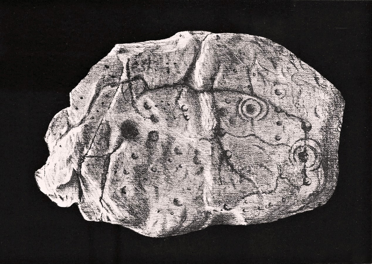
The geographical position of this site was shown on the 1897 Ordnance Survey map, albeit in the past tense as it had been destroyed not long after after being uncovered. Thankfully however, local antiquarian Mick Taylor (1882; 1883) did a damn good job recording what had been found here, and although he had remains of the stone in his possession shortly after it had been found, the carving has subsequently been lost. Thankfully Mr Taylor left us with a good drawing of the design (right).
Located a short distance west of the grand henges of Mayburgh and King Arthur’s Round Table, the carving was found some ten inches below the ground during work that was being done to lay some new fencing. The lads doing the work hit some stone and found it to be covered with a number of standard cup-and-ring motifs facing downwards. This carved stone, wrote Taylor (1882), was in fact “the cover of a kist-vaen”, a.k.a, prehistoric stone burial cist. He then proceeded to give a lengthy account of the site and the carving, telling:
Site shown on 1897 map
“There are traces of ancient occupancy, and vestiges of cairn structure still to be discerned on the hill-side on which it was found, but no barrow nor mound covered this particular grave. A space had been excavated for the interment dipping into the limestone rock to a depth of about 3 feet; the length of the grave was 4 feet, and the breadth about 3 feet 6 inches. Cobble stones had been used partially to line the cavity, but there was no flagging at the sides or bottom. The space was filled with blackish soil, amid which was a quantity of burnt bones, all in a fragmentary state. No implement nor shreds of pottery could be found, but there were several pieces of charcoal. It had evidently been an interment of cremated remains.
“The massive stone which formed the cover of the kistvaen I saw in situ immediately after its discovery.
Beckensall’s impression of the design
“This stone is a natural slab of white freestone; it is of a broadish ovoid form, 5 feet 4 inches long, and at the centre 3 feet 6 inches broad, tapering towards each end; and it varies from 8 inches to 13 inches in thickness. The superior surface is rough and irregular, and scored in many places with marks of the ploughshare and harrows, which have passed over it in frequent cultivation. The interior surface, which was presented towards the grave, shows a fairly smooth cleavage, and on it were carved the sculptured markings which I shall describe.
“The slab, which is in my possession, was unfortunately broken in three or four pieces by the hammer of the workman, but I have put it together, and when viewed with a certain light when the shadows are deep, the sculpturings may be well made out, and appear to be arranged as follows: near the bottom there is a central cup deeply carved, about 3 inches in diameter; around this there are two concentric rings, somewhat faintly incised, the outermost of which has a diameter of 6 inches. From this central cup proceed two grooves 6 inches long, which bisect the concentric circles, and traverse in a straight line to join a similar cup on each side of the central one. From this line of cups three gutters meander upwards over the surface of the slab; the main channel takes a direction upwards on the right side of the stone, and receives a number of branches like the tributaries of a river from each side, and terminates on the free margin of the upper part of the stone. On the lowest quarter of the stone to the right there is a large hollow cup 3 inches in diameter, around which also there are two well-executed concentric rings, the largest with a diameter of 6 inches. These rings are cut by a radial groove which joins a gutter in the centre of the stone, and in the opposite direction, at a point in their circumference, they fall into and are subtended by the larger side channel. These are the only two cuttings on the stone which present this annular arrangement; on the other hand, the simple cup markings are numerous, in fact, twenty-four may be counted. One of these cups is greatly larger than any of the rest. It is situated in the centre of the upper half of the slab, and on first view forms the most strikingly characteristic feature of the tablet. This cup is 6 inches in diameter, and is carved out to the depth of 3 inches. The chisel marks are distinct and fresh, as if done yesterday; and there is a smoothness and regularity of execution about it, which evinces that more pains have been taken with it than with some of the other incisions. The other cup-markings vary from 1 inch to 3 inches in measurement. A number of them (about twelve of them may be counted) are associated with the furrowed lines, either forming the beginning of a gutter, or joining or being included in the line of the channel itself. These form the series of the larger cup-markings, and are an inch or more in depth. On the other hand, others of these cups are isolated, and scattered singly, and apparently without regular order over the surface, and unconnected with the branch-like lines; these for the most part are mere shallow depressions, and with less defined margins. Again, there is another class of markings on the stone; they are very numerous, and are dispersed apparently irregularly over all the surface; these are little pits or pick marks, small irregular holes picked into the stone, evidently done with some pointed tool.”
Taylor thought that these “small irregular holes” had been made with a flat-edged chisel whacked with a hammer, and the cup-marks “by a flint or harder stone.” In examples I’ve found in Perthshire where the tools have been left at the site, both a harder stone was found at one (for some reason actually laid within the cup-mark and left there before it had been finished), whilst a flint was laid in the cup-mark of another carving (although that example seemed to be more a deliberate deposit rather than being the tool that made the carving).
Anyhow, considering the poor condition of the carving when Taylor described it—”broken in three or four pieces”—there’s little likelihood of it having survived. But, on the off-chance that someone’s mum or granny has it hiding in the rockery at the back of the garden somewhere, give us a shout….
References:
Beckensall, Stan, Cumbrian Prehistoric Rock Art, Abbey Press: Hexham 1992.
Beckensall, Stan, Prehistoric Rock Art in Cumbria, Tempus: Stroud 2002.
Taylor, Michael W., “On a Sculptured Stone with Cup and Ring-Markings, found at Redhills, near Penrith,” in Proceedings Society of Antiquaries Scotland, volume 16, 1882.
Taylor, Michael W., “On a Cup-marked Stone found at Redhills, near Penrith,” in Transactions Cumberland & Westmorland Antiquarian & Archaeological Society, volume 6, 1883.
Acknowledgements: Huge thanks for use of the Ordnance Survey map in this site profile, reproduced with the kind permission of the National Library of Scotland.
Stone Circle (destroyed): OS Grid Reference – NY 549 182
Archaeology & History
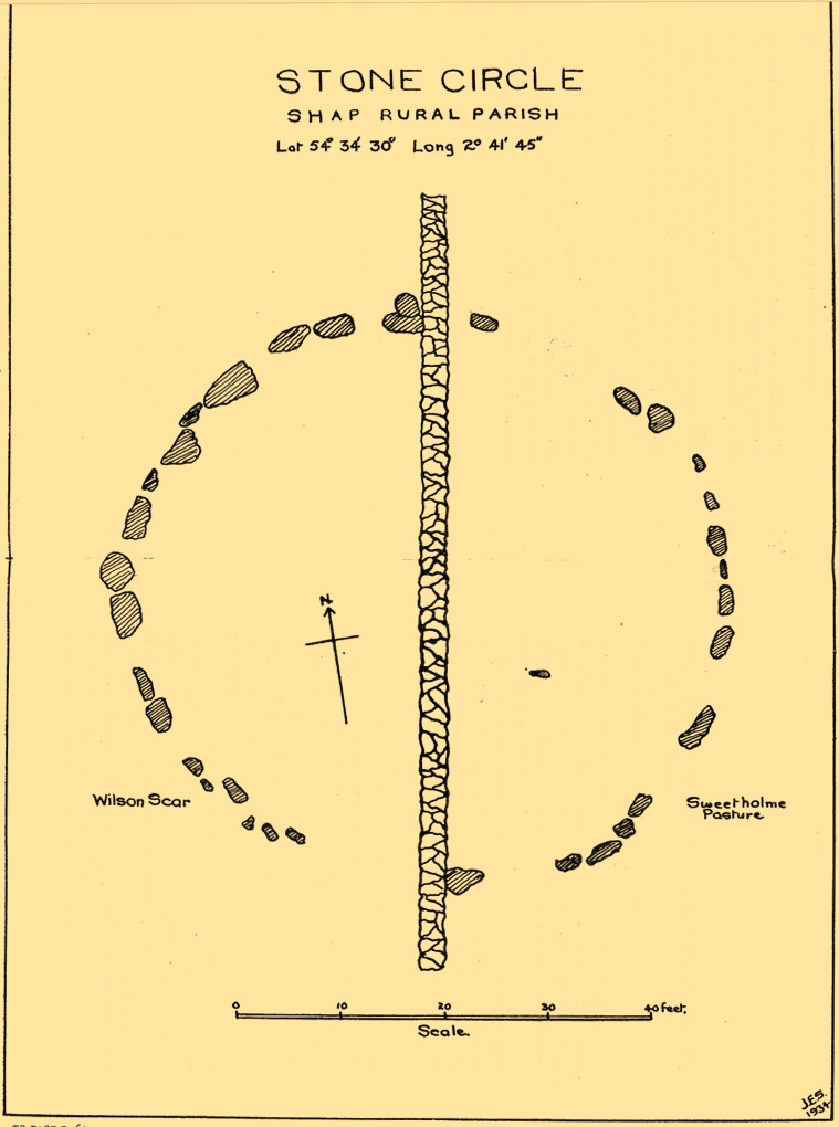
This site has been completely destroyed by the huge eyesore of a quarry that we all see when we’re travelling up the M6 north, above Shap. John Waterhouse (1985) told that “a rescue excavation” was carried out here with help from the kids at Penrith Queen Elizabeth School, shortly before its destruction in 1952, but now there is no trace left of it. When it was first described by J.E. Spence (1935), the circle had already been damaged by a wall that cut right through its centre. He told:
Spence’s 1935 plan
“The circle, which is 6o feet in diameter, is composed of 35 stones, 20 being on the west and 15 on the east side of the boundary wall running through the circle from north to south. The stones of which the circle is composed are Borrowdale erratics, a large number of which are scattered over the adjoining ground on both sides of the wall but more thickly in Sweet Holme Pasture. The stones, which vary up to 5 feet 9 inches by 3 feet, are larger and more numerous in the north-west quadrant where the tallest stands 1 foot 8 inches above the level of the turf. The ground within the circle is level, but to the south and west it slopes gently down from the edge of the circle in such a manner as to suggest that the area within the circle has been levelled.”
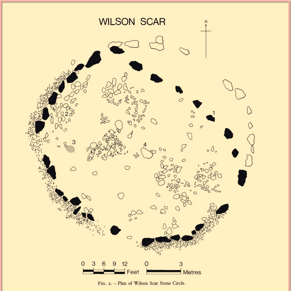
1952 plan laid over Spence’s 1935 plan
Spence told that an ancient “sunken trackway” led outwards from the circle to the south-west in the direction of Rosgill, but when the 1952 excavation occurred, no remains of such a track were found; nor was the wall that had cut through it; and the north-easterly section of the circle had been cut into and re-laid, presumably by the quarrymen. It was quite plain, wrote G.G. Sieveking (1984), “that this portion of the monument was encroached upon in the summer of 1952, and hastily reconstructed for the benefit of the archaeologists.”
Their excavation found that some internal sections of this ring had been paved with thin limestone slabs and they also uncovered two small cairns, neither of which possessed anything. However, they did find four funerary deposits within the monument: one at the northeastern section of the circle (no.1); another near the centre (no.4); and remains of a cremation west of centre (no.3); but the most complete find was at the western side of the ring, where a “disarticulated inhumation burial was lying immediately beneath the turf line in a shallow grave 1.35 m long, surrounded by a setting of small boulders.” It was a near complete human skeleton. This place was obviously, at times, used in ceremonies for the dead.
Shortly after the archaeological examination of the site, it was blasted away by quarrying. Gone!
References:
Barnatt, John, Stone Circles of Britain– volume 2, BAR: Oxford 1989.
Burl, Aubrey, The Stone Circles of Britain, Ireland and Brittany, Yale University Press 2000.
Farrah, Robert W.E., A Guide to the Stone Circles of Cumbria, Hayloft: Kirkby Stephen 2008.
Seton, Ray, The Reason for the Stone Circles in Cumbria, privately published: Morecambe 1995
Sieveking, G.G., “Excavation of a Stone Circle at Wilson Scar, Shap North 1952,” in Transactions Cumberland & Westmorland Antiquarian & Archaeological Society, volume 84, 1984.
Spence, J.E., “A Stone Circle in Shap Rural Parish,” in Transactions Cumberland & Westmorland Antiquarian & Archaeological Society, volume 35, 1935.
Waterhouse, John, The Stone Circles of Cumbria, Phillimore: Chichester 1985.
Holy Well (lost): OS Grid Reference – NY 0562 0303
Archaeology & History
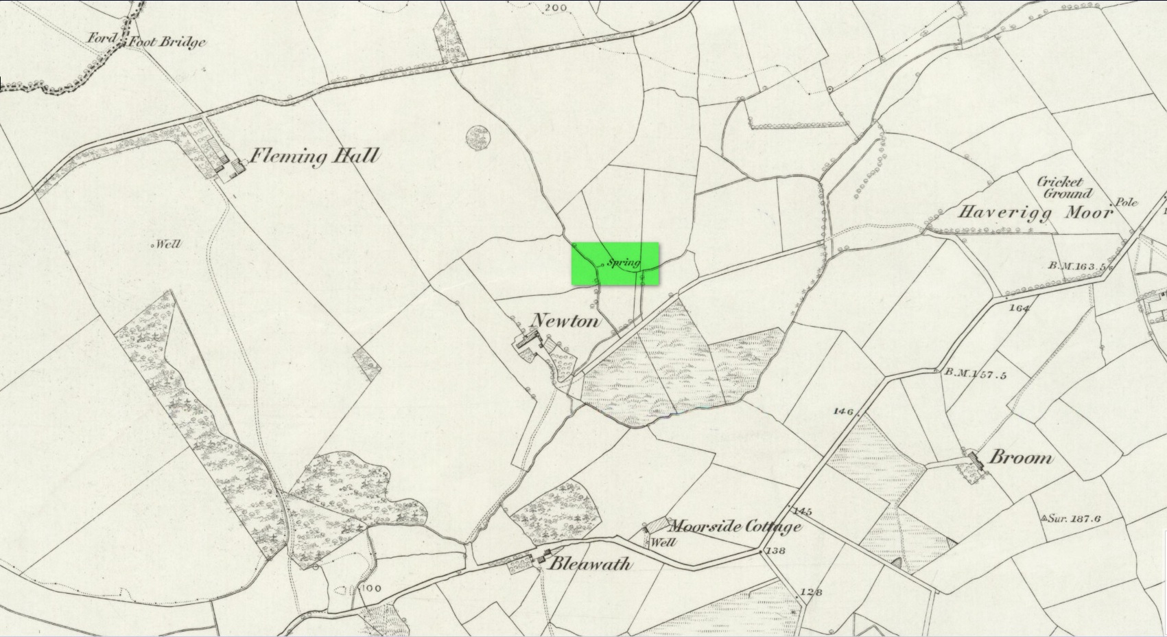
Described as being “lost” in John Musther’s (2015) relatively recent survey, very little has been written about this site but, by the look of things, it may still exist—albeit in a boggy state of affairs! It was mentioned in Parker’s (1926) classic history book of the area:
“Near to Newton is a very plentiful spring which is known to have been moved further from the house than it was. Adam de Newton, son of Richard, mentions in one of his grants, “St. Helen’s Well, which is at the corner of my garden, the outfall going into Grucokesgile beck.”
Possible site of the Well
Parker found it to have been described in a local property charter in St Bee’s Register (Wilson 1915) as far back as 1220 CE. On the earliest OS-map of the area, a “Spring” is shown just above Newton, which may mark the very spot! Not far from the holy well was also a cross-marked stone called the Grey Stone (grey stones are usually boundary stones, but can also be standing stones—of which there were a lot in this neck o’ the woods).
Folklore
St. Helen’s Day was celebrated on August 18, but there seem to be no accounts of traditional customs recorded here.
References:
Harte, Jeremy, English Holy Wells – volume 2, Heart of Albion press: Wymeswold 2008.
Musther, John, Springs of Living Waters, privately printed: Keswick 2015.
Page, Jim Taylor, Cumbrian Holy Wells, North West Catholic History Society: Ormskirk 1990.
Parker, C.A. The Gosforth District: Its Antiquities and Places of Interest, Thomas Wilson: Kendal 1926.
Cross (destroyed): OS Grid reference – SD 5152 9280
Also Known as:
Cold Stone
Market Cross
Archaeology & History
Not to be confused with the carved cross fragments held in the local church, this old town cross has long since gone. It’s existence was recorded by the great Kendal historian Cornelius Nicholson (1861), but even in his day, this “obstruction” as he called it, was no longer standing. Known as the local Market Cross where all the wheeling and dealing took place—official ones, as well as the not-so-official works of local folks—it stood just off Stricklandgate,
“opposite the Covered Market, and was an obstruction in the street. There still remains a remnant of it in a stone at the corner, vulgarly called “cold stone,” where the charters and so forth were usually proclaimed. Cold stone is a corruption of “call stone;” an appendage common to most ancient towns, where all public matters were “called” prior to the “institution” of belman.”
This folk etymology of “cold” needs to kept in mind when we come across other stones of this name. …The earliest record of a market held at Kendal is from 1402, but written records of the Market Cross are scant until 1714. Such edifices tend to be architecturally ornate, but we have neither sketches nor descriptions of this lost site and must await the work of fellow researchers who may hopefully find out more.
References:
Nicholson, Cornelius, The Annals of Kendal, Whitaker & Co.: London 1861.
Smith, A.H., The Place-Names of Westmorland – volume 1, Cambridge University Press 1967.
Maypole (destroyed): OS Grid reference – SD 5161 9212
Archaeology & History
Long since gone, it’s existence was recorded by, amongst others, the Kendal historian Cornelius Nicholson. (1861) He described it in relation to one of the town crosses, that was removed due to it being “an obstruction in the street.” The maypole too, he said,
“was another incumbrance, but indispensable, according to the custom of our forefathers. It stood in Kirkland, opposite the house of the late Thomas Reveley, Esq., and was suffered to remain till within eighty years ago. In the time of our good Queen Katherine, who may fairly be supposed to have partaken of the amusements, countenanced by her royal consort, the original festivity of maying and morris-dancing would be here celebrated, by the annual ceremony of “maying” when, immediately after sunrise, on the 1st of May, processions, entering the town at various inlets, streamed through the streets, with music of horns and flutes; boys with their May-gads (willow-wands twined with cowslips), and girls with their “brats” full of flowers — young and old alike joining in merry laughter, and song, and the customary chorus, “We have brought the summer home.” When the above-named ceremonies became less fashionable, the May Pole was made the rendezvous of all the milkmaids in the neighbourhood, who came and paraded round it on Easter Mondays. On other occasions of rejoicing, afterwards, such for instance, as terminating an apprenticeship, and the like, it became customary for young men to go and dance around it.”
The author then told that this annual village ceremony was still being performed at the beginning of the 19th century, “in the assemblage of young people in the Vicar’s Fields, on Easter Tuesday. After spending the afternoon there, they returned in procession through the streets, threading grandy needles.”
References:
Nicholson, Cornelius, The Annals of Kendal, Whitaker & Co.: London 1861.
Early photo of holy well site (Henry Taylor, 1906)
To get here you have to travel right to the end of the road, then walk a short distance until you hit the horrible coastal waters where there’s a natural rock arch. Just before here, on the west-facing side, is this famous holy well.
Archaeology & History
Just before this little-known sacred well is a cavity in the limestone rock which is called the Fairy Church, and a couple of hundred yards below here is another one which was known as the Fairy Chapel. This region was obviously of sacred importance to our ancestors – and should still be to those of us with ecological concerns. The waters from this well were said to cure poisons from the body. It was written about at some length in Mr Taylor’s (1906) superb survey, where he collated material from a series of other early tracts describing the well. He wrote:
“This celebrated medicinal well is said to have been used by lead miners from the time of the Romans. The patients come for a two or three days’ stay to “get the poison out of their systems.” The site is three and a half miles nearly due south from Cartmel. The water, which has a very peculiar taste, comes down from the hillside and flows into a small artificial basin or grotto. The key of the door is kept at a neighbouring farmhouse. Close to the well is an untenanted building formerly used by indigent sufferers. The wooded cliff forming ‘The Head’ is of singular beauty, overlooking the waters and sands of Morecambe Bay. On Hennet’s map of Lancashire (1828) the well is called ‘Spa Holy Well.’
“…Mr. W. O. Roper, in his Churches, Castles, and Ancient Halls of North Lancashire, writes: “One other appendage to the Priory of Cartmel should be mentioned, and that is the well known as the Holy Well. On the sea-shore, close under the towering cliffs of Humphrey Head, and almost immediately below the natural arch of rock which leads to the recess known as the Fairy Chapel, bubbles the well to which in former days the Priors journeyed in state from their neighbouring Priory, and to which in more recent times large numbers of people resorted, hoping to derive benefit from its medicinal qualities.”
“Mr. James Stockdale, in Annals of Cartmel, writes: “Near to this holy well (Humphrey Head) are two cavities in the mountain limestone rock called the ‘Fairy Church’ and the ‘Fairy Chapel,’ and about three hundred yards to the north there used to be another well, called ‘Pin Well’, into which in superstitious times it was thought indispensiable that all who sought healing by drinking the waters of the holy well should, on passing it, drop a pin; nor was this custom entirely given up till about the year 1804, when the Cartmel Commoners’ Enclosure Commissioners, on making a road to Rougham, covered up this ‘Pin Well’. I have myself long ago seen pins in this well, the offerings, no doubt, of the devotees of that day.”
“Mr. Hope, in his Holy Wells of England, says that “this is a brackish spring celebrated as a remedy for stone, gout, and cutaneous complaints. The water issues from a projecting rock of limestone, called Humphrey Head and its medicinal qualities occasion a considerable influx of company to Cartmel, Flookborough, Kent’s Bank and Grange during the summer months…”
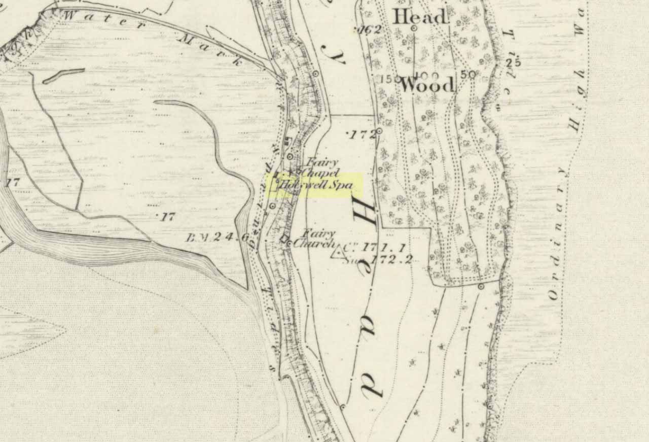
Holy Well on 1851 map
The site was clearly marked in 1851 on the first OS-map of the area as the Holywell Spa, and the attendant Fairy Chapel and Fairy Church shown as two distinctly separate places, very close by.
References:
Hope, Robert Charles, Legendary Lore of the Holy Wells of England, Elliott Stock: London 1893.
Taylor, Henry, The Ancient Crosses and Holy Wells of Lancashire, Sherratt & Hughes: Manchester 1906.
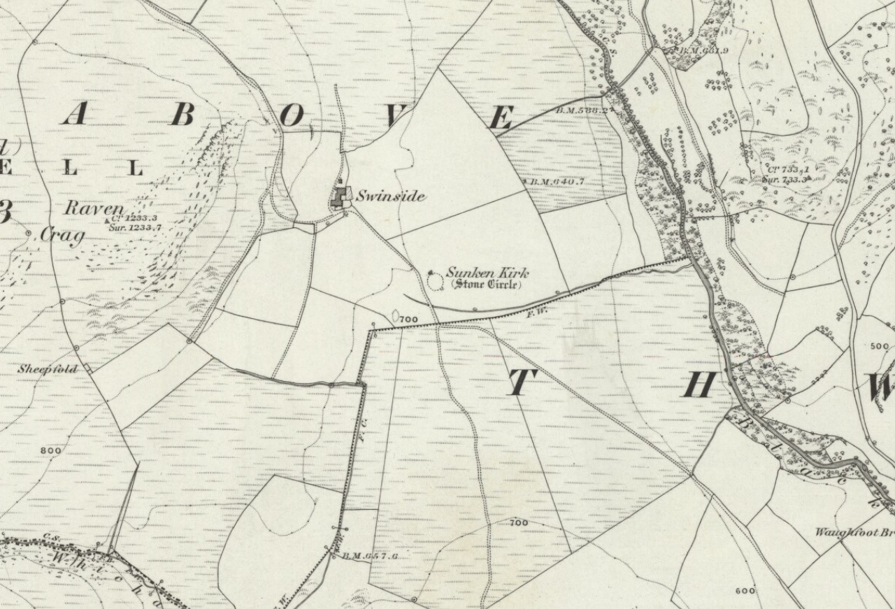
Bittova journey this — but well worth it! From Broughton-in-Furness take the A595 road west, past Duddon Bridge for about another 1½ miles, turning right up the small single-track country lane beloved of city-mind drivers, up the fertile scruffy road, past Broadgate and stopping just before Cragg Hall Farm. There’s a dirt-track running up the back of Cragg Hall. Go up here and keep walking for a mile or so until, as you approach Swinside Farm and the fields open up in front of you, the stones begin to appear.
Archaeology & History
Swinside, looking east
The Swinside stone circle is Aubrey Burl’s favourite. And for good reason! Like other impressive megalithic rings of the region, the stones are large, well set, and the landscape holds the stones finely in the hills. Without the landscape here, Swinside (like Castlerigg and elsewhere) would not have such grandeur. When you sit in the ring, or walk round it, Knott Hill to the south was of obvious mythic relevance to the people who built this stone circle four or five thousand years ago. But this can be said of many of the surrounding crags. A few miles southwest we see the top of the haunted Black Combe rising into clouds, still speaking to some with spirits from animistic realms, long known to our ancestors. Following the skyline west and past the small falls of Whicham stream, whose name speaks of long past trees, we reach the near-west skyline with the cairn-looking pap of the Raven Crag, symptomatic of magickal rites calling to and beyond the circle. To the north is the symbolic ridge of Lath Rigg. Along the craggy eastern ridges from here you get the impression that you’re more in Argyll than Cumbria; and the break in the hills to the southeast reaches to the distant pinnacle of Kirkby Moor, where the midwinter sunrise emerged to tell of solar calendrical motions and the coming of the dark season to our megalithic tribes. But enough of the landscape!
Swinside on 1867 OS-map
Although the name Swinside can be traced back to the 13th century, the local folk-name of the circle—Sunken Kirk—was mentioned for the first time as “the Chapell Suke” in Parish Registers of 1624. No earlier literary source has yet been identified, probably because of the isolation of the site and the lack of people writing about the area. Swinside stone circle is, just about, a perfect circle, give or take a foot here and there, holding the circular dome of the heavens within its domain. Yet despite its almost regal appearance, early references to the site seem scant. It seems to have been first described in William Hutchinson’s huge History of Cumberland (1794), where he told:
“In the neighbourhood of Millum, at a place called Swinside, in the estate of William Lewthwaite Esq., of Whitehaven, is a small but beautiful druidical monument; it is circular, about twenty eight yards in diameter; the stones of which it is composed are from six to eight feet high, all standing and complete. A little to the south, is another of larger dimensions, but not in so perfect a state: the neighbouring people call those places by the emphatical names of Sunken Kirks.”
A few years later, William Camden’s legendary text Britannia was edited and reprinted again, this time by Richard Gough (1806), who told:
“At Swineshead, a very high hill…is a druidical temple, which the country folk call Sunken Kirk, i.e., a church sunk into the Earth. It is nearly a circle of very large stones, pretty entire. No situation could be more agreeable to the Druids than this; mountains almost encircle it, not a tree is to be seen in the neighbourhood, nor a house, except a shepherd’s cot at the foot of a mountain surrounded by a few barren pastures. At the entrance are four large stones, two placed on each side at the distance of six feet. The largest on the left hand side is five feet six inches in height, and ten feet in circumference. Through this you enter into a circular area, 29 yards by 30. This entrance is nearly southeast. On the north or right-hand side is a huge stone of conical form, in height nearly nine feet. Opposite the entrance is another large stone which has once been erect, but is now fallen within the area: its length is eight feet. The left hand or southwest is one, in height seven feet, in circumference 11 feet nine inches. The altar probably stood in the middle, as there are some stones still to be seen, though sunk deep in the earth. The circle is nearly complete, except on the western side some stones are wanting. The largest stones are about thirty one or two in number. The outwards part of the circle upon the sloping ground is surrounded with a buttress or rude pavement of smaller stones raised about half a yard from the surface of the Earth… This monument of antiquity, when viewed within the circle, strikes you with astonishment, how the massy stones could be placed in such regular order either by human strength or mechanical power.”
Tall, northernmost stone to centreNortheast section of the ring
It seems he was impressed! Yet despite this, in the 19th century not many folk strayed this far into the western edges of Lakeland to look upon Swinside. There were occasional descriptions from travellers and antiquarians such as J.T. Blight (1843) and Edwin Waugh (1861), each speaking of the site’s visual magnitude, but it wasn’t until archaeologist C.W. Dymond came here, first in 1872 and then again in 1877, that a fuller account of the site came into being. In his essay on a “Group of Cumberland Megaliths,” he said how the stones were still in excellent condition and that,
“few of the stones seem to have been removed — probably because plenty of material for walling and road-making could be collected from the neighbouring hillside.” (Dymond 1881)
When Mr Dymond first came here he told of the remains of a rowan tree which had split one of the stones, but this has long gone. More than twenty years after the archaeologist’s first visit, he returned with R.G. Collingwood to make a more detailed evaluation of the ring. He measured and planned Swinside like it had never been done before and his ground-plan (below) is still very accurate indeed. Aubrey Burl (1999) takes up the story:
“The ring was partly excavated by Dymond, Collingwood and three men from midday Tuesday, 26 March 1901, until the close of the following evening. They dug two long, intersecting 46cm-wide trenches, NW-SE, NE-SW, across the ring with a curious zigzagging pattern of others between southeast and southwest: an investigation of some 51m² of the central area. Within the circle the trenches represented less than a thirteenth of the 642m² of the interior.
“Below the grass and turf was a thin layer of soil under which yellowish marl or ‘pinnel’ varied from 15cm to 75cm in depth, being deepest at the entrance which had been dug into earlier around 1850. Wherever it was uncovered the gravelly marl was wavily uneven, presumably the result of ploughing. The bases of the circle-stones rested on the pinnel, held firmly in their holes by small cobbles with others heavily packed around the sides. The only finds were a nut-sized lump of charcoal just northeast of the centre with others near the entrance; a minute splinter of decayed bone near the first bit of charcoal and two pieces of red stone. There were also some contemporary glass sherds and a Lancaster halfpenny dated between 1789 and 1794 lying in the uppermost turf layer.”
Dymond’s 1881 plan of Swinside
Since these early archaeological digs, Swinside has given up little else. Much like other stone circles in the British Isles, few real clues as to exactly what went on here have been forthcoming. But in the 1960s, investigations into megalithic sites made a bit of a quantum leap and some old ideas about astronomical ingredients were resurrected.
Alexander Thom’s plan of Swinside
Swinside was one of the places explored by engineer and megalith enthusiast, Alexander Thom. Thom was one of the prime figures instrumental in the resurgence of interest in megalithic sites — and his finds of megalithic astronomy and prehistoric mathematics had a lot to do with it. Although we know today that some of Thom’s work isn’t correct, his explorations and research stand him far ahead of most archaeologists who pretended to represent this area of research. He left us with the most detailed ground-plans of megalithic sites to date and, of course, showed some fascinating alignments.
Thom listed Swinside as site “L1/3” and made the most detailed and accurate ground-plan of this and 18 other megalithic rings in Cumbria. He found it to be 94 feet in diameter, with an internal area measuring 6940 square feet. The one major alignment Thom found at Swinside was of the winter solstice sunrise, lining up just on the edge of the ‘entrance’ to the circle’s southeastern side.
Folklore
Like a number of other stone circles, folklore told that you couldn’t count the stones. Janet and Colin Bord (1997) also told that people once tried to build a church here in early christian days, but once the builders went home in the evening, the Devil pulled down what they’d built during the day. A motif found at Ilkley’s Hanging Stones cup-and-ring carvings and many other prehistoric sacred sites in the country.
References:
Armstrong, A.M. et al., The Place-Names of Cumberland – volume 2, Cambridge University Press 1950.
Bord, Janet & Colin, Prehistoric Britain from the Air, Weidenfeld & Nicolson: London 1999.
Burl, Aubrey, “‘Without Sharp North…’ – Alexander Thom and the Great Stone Circle of Cumbria”, in Ruggles, Clive, Records in Stone, Cambridge University Press, 1988.
Burl, Aubrey, A Guide to the Stone Circles of Britain, Ireland and Brittany, New Haven & London 1995.
Burl, Aubrey, Great Stone Circles, Yale University Press: New York & London 1999.
Burl, Aubrey, The Stone Circles of Britain, Ireland and Brittany, Yale University Press 2000.
Dymond, C.W., “A Group of Cumberland Megaliths,” in Transactions of the Cumberland and Westmorland Antiquarian and Archaeological Society, volume 5, 1881.
Dymond, C.W., “An exploration at the Megalithic Circle called Sunken Kirk at Swinside, in the Parish of Millom, Cumberland,” in Transactions of the Cumberland and Westmorland Antiquarian and Archaeological Society, New Series volume 2, 1902.
Gough, Richard (ed.), Camden’s Britannia, J. Nichols and Son: London 1806.
Hutchinson, William, The History of the County of Cumberland – volume 1, F. Jollie: Carlisle 1794.
Seton, Ray, The Reason for the Stone Circles in Cumbria, R. Seton: Morecambe 1995.
Thom, Alexander, Megalithic Sites in Britain, Oxford University Press 1967.
Thom, A., Thom, A.S. & Burl, H.A.W., Megalithic Rings, BAR: Oxford 1980.
Waterhouse, John, The Stone Circles of Cumbria, Phillimore: Chichester 1985.
Waugh, Edwin, Seaside Lakes and Mountains of Cumberland, Alexander Ireland: Manchester 1861.
ACKNOWLEDGEMENTS:
Huge thanks to Brian Else for his photos. And to Paul and Tricia for taking us here, in awesome downpour weather!
As with many old churches, St. James’ at the northern side of the village has remains of old cross fragments that can be seen inside. They were described at some length in W.S. Calverley’s (1899) excellent work on such monuments. Mr Langham (1972) also gave a good account of the respective cross fragments in his short work on this history of the church, listing the sections as a, b, c, d and e. He wrote:
“a) the greater part of a wheel-head, the reverse side of which has a sunk centre instead of a raised boss, making it a five hole cross. Calverley remarks, “a rarity in the district.”
“b) probably the top of a shaft having on its face a panel with a defaced figure, and conventional ornaments on the side.
“c) probably the lower part of a shaft with figures in two panels, and with incised interlacing designs on the reverse side “of late Scandinavian type, resembling fibulae of the Viking Age.” On the face, the lower panel is Christ risen or rising from the tomb. He is trampling on a serpent and carries a palm of victory in his left hand. The panel above has two figures, suggested by Calverley to be “either John or Mary, or two angels.”
“d) the neck of a cross. Calverley notes that the execution of the wheel-head and the shaft-fragments was by a hacking not a chiselling method, and he makes the comment: “The shafts and head at Burton are similar in workmanship to those at Halton. The Halton crosses and not Norse in style, but are like late pre-Norman work in Yorkshire, where the Danes lived.”
“e) a part of a second shaft with a zigzag pattern. Calverley says that “it is neatly chiselled, and the designs suggests a Norman date, although it seems to belong to a cross of Saxon type.” The Royal Commission volume dates it as the 10th or 11th century.”
St James church cross (by M.D.S. Brown-Smith)
The Royal Commission volume dates the cross shafts as “probably late 10th century.” Sir Nikolaus Pevsner in a recent book, Guide to Cumberland and Westmorland states specifically that, “Christ, the Virgin and St. John are on the Burton-in-Kendale cross.” This is too explicit a statement in view of the deterioration in the detail.
Nearby to the northeast used found to be the remains of a holy well dedicated to St. Helen. Does anyone have further information about it?
References:
Calverley, W.S., Notes on the Early Sculptured Crosses, Shrines and Monuments in the Early in the Present Diocese of Carlisle, T. Wilson: Kendal 1899.
Langham, John G., Parish Church of St. James, Burton-in-Kendal, Mayoh Press: Carnforth 1972.
Cup-and-Ring Stone: OS Grid Reference – NY 0708 2536
Getting Here
Photo & drawing of Dean’s cup-and-ring (after Beckensall 1992)
St Oswald’s church stands at the western edge of the village of Dean beside the road to Branthwaite. The village is located some 5 miles due south-west of Cockermouth and about 6 miles to the south-east of Workington.
Archaeology & History
In the nave of St Oswald’s church there is now housed a small sandstone boulder that has a well-defined central cup-mark around which are two large concentric rings, a third ring being left open – perhaps indicating a portal (gateway), and three other well defined cup-marks at the side of that, one of which has become almost adjoined to the other through erosion.
The boulder was ploughed up in a field at nearby Park Hill to the south-west of the village in 1918. It was then placed in the churchyard but, in recent times it was brought into the church for safety reasons.
References:
Beckensall, Stan, Cumbrian Prehistoric Rock Art, Abbey Press: Hexham 1992.
Beckensall, Stan, British Prehistoric Rock Art,Tempus: Stroud 1999.
Beckensall, Stan, Prehistoric Rock Art in Cumbria, Tempus: Stroud 2002.
Stone Circle (destroyed): OS Grid Reference – NY 37 50
Archaeology & History
Listed in Burl’s (2000) magnum opus, this is another long-lost megalithic ring, whose exact location seems to have been forgotten. An early description of the site by William Whellan (1860) told us that,
“There was formerly a circle of rude stones, ten yards in diameter, near the village, supposed to have been the remains of a Druidical temple; and a little distance from it, was a tumulus, three yards high and eight in diameter.”
More than a hundred years later in Waterhouse’s (1985) fine survey, he described the circle, saying:
“It lay near the village of Dalton…near the River Caldew… An 18th century account describes it as consisting of ‘rude’ stones…set in a circle of diameter about 27m. East of the the centre of the circle were four large stones lying on top of each other. They may have been the remains of a cist, or possibly a tumbled cove, like that inside the circle-henge of Arbor Low in Derbyshire. A tumulus may have stood nearby.”
There are however some discrepancies in the descriptions between Whellan and Waterhouse. In the former, the site of Chapel Flat is talked of separately as being the abode of a hermit in the lost chapel of St. Wynemius, “in a deep and romantic part of the vale of Caldew.” The description of the stone circle immediately follows this, but is spoken of as merely being “near the village.”
Does anyone know anything further about this once important site? Did the lost hermitage on Chapel Flat actually have anything to do with the stone circle?
References:
Burl, Aubrey, The Stone Circles of Britain, Ireland and Brittany, Yale University Press 2000.
Waterhouse, John, The Stone Circles of Cumbria, Phillimore: Chichester 1985.
Whellan, William, The History and Topography of the Counties of Cumberland and Westmoreland, Comprising their Ancient and Modern History, W.Whellan: Pontefract 1860.


")
")