Town Cross, Kendal, Westmorland

Cross (destroyed):  OS Grid reference – SD 5152 9280

Also Known as:

  1. Cold Stone
  2. Market Cross

Archaeology & History

Not to be confused with the carved cross fragments held in the local church, this old town cross has long since gone.  It’s existence was recorded by the great Kendal historian Cornelius Nicholson (1861), but even in his day, this “obstruction” as he called it, was no longer standing.  Known as the local Market Cross where all the wheeling and dealing took place—official ones, as well as the not-so-official works of local folks—it stood just off Stricklandgate,

“opposite the Covered Market, and was an obstruction in the street.  There still remains a remnant of it in a stone at the corner, vulgarly called “cold stone,” where the charters and so forth were usually proclaimed.  Cold stone is a corruption of “call stone;” an appendage common to most ancient towns, where all public matters were “called” prior to the “institution” of belman.”

This folk etymology of “cold” needs to kept in mind when we come across other stones of this name.  …The earliest record of a market held at Kendal is from 1402, but written records of the Market Cross are scant until 1714. Such edifices tend to be architecturally ornate, but we have neither sketches nor descriptions of this lost site and must await the work of fellow researchers who may hopefully find out more.

References:

  1. Nicholson, Cornelius, The Annals of Kendal, Whitaker & Co.: London 1861.
  2. Smith, A.H., The Place-Names of Westmorland – volume 1, Cambridge University Press 1967.

© Paul BennettThe Northern Antiquarian

Kendal Maypole, Kendal, Westmorland

Maypole (destroyed):  OS Grid reference – SD 5161 9212

Archaeology & History

Long since gone, it’s existence was recorded by, amongst others, the Kendal historian Cornelius Nicholson. (1861)  He described it in relation to one of the town crosses, that was removed due to it being “an obstruction in the street.”  The maypole too, he said,

“was another incumbrance, but indispensable, according to the custom of our forefathers.  It stood in Kirkland, opposite the house of the late Thomas Reveley, Esq., and was suffered to remain till within eighty years ago.  In the time of our good Queen Katherine, who may fairly be supposed to have partaken of the amusements, countenanced by her royal consort, the original festivity of maying and morris-dancing would be here celebrated, by the annual ceremony of “maying” when, immediately after sunrise, on the 1st of May, processions, entering the town at various inlets, streamed through the streets, with music of horns and flutes; boys with their May-gads (willow-wands twined with cowslips), and girls with their “brats” full of flowers — young and old alike joining in merry laughter, and song, and the customary chorus, “We have brought the summer home.”  When the above-named ceremonies became less fashionable, the May Pole was made the rendezvous of all the milkmaids in the neighbourhood, who came and paraded round it on Easter Mondays.  On other occasions of rejoicing, afterwards, such for instance, as terminating an apprenticeship, and the like, it became customary for young men to go and dance around it.”

The author then told that this annual village ceremony was still being performed at the beginning of the 19th century, “in the assemblage of young people in the Vicar’s Fields, on Easter Tuesday.  After spending the afternoon there, they returned in procession through the streets, threading grandy needles.”

References:

  1. Nicholson, Cornelius, The Annals of Kendal, Whitaker & Co.: London 1861.

© Paul BennettThe Northern Antiquarian

St. James Church cross, Burton-in-Kendal, Cumbria

Cross:  OS Grid Reference – SD 5305 7692

Archaeology & History

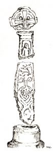
As with many old churches, St. James’ at the northern side of the village has remains of old cross fragments that can be seen inside.  They were described at some length in W.S. Calverley’s (1899) excellent work on such monuments.  Mr Langham (1972) also gave a good account of the respective cross fragments in his short work on this history of the church, listing the sections as a, b, c, d and e.  He wrote:

“a) the greater part of a wheel-head, the reverse side of which has a sunk centre instead of a raised boss, making it a five hole cross.  Calverley remarks, “a rarity in the district.”

“b) probably the top of a shaft having on its face a panel with a defaced figure, and conventional ornaments on the side.

“c) probably the lower part of a shaft with figures in two panels, and with incised interlacing designs on the reverse side “of late Scandinavian type, resembling fibulae of the Viking Age.”  On the face, the lower panel is Christ risen or rising from the tomb. He is trampling on a serpent and carries a palm of victory in his left hand.  The panel above has two figures, suggested by Calverley to be “either John or Mary, or two angels.”

“d) the neck of a cross. Calverley notes that the execution of the wheel-head and the shaft-fragments was by a hacking not a chiselling method, and he makes the comment: “The shafts and head at Burton are similar in workmanship to those at Halton.  The Halton crosses and not Norse in style, but are like late pre-Norman work in Yorkshire, where the Danes lived.”

“e) a part of a second shaft with a zigzag pattern.  Calverley says that “it is neatly chiselled, and the designs suggests a Norman date, although it seems to belong to a cross of Saxon type.”  The Royal Commission volume dates it as the 10th or 11th century.”

St James church cross (by M.D.S. Brown-Smith)

The Royal Commission volume dates the cross shafts as “probably late 10th century.”  Sir Nikolaus Pevsner in a recent book,  Guide to Cumberland and Westmorland states specifically that, “Christ, the Virgin and St. John are on the Burton-in-Kendale cross.” This is too explicit a statement in view of the deterioration in the detail.

Nearby to the northeast used found to be the remains of a holy well dedicated to St. Helen.  Does anyone have further information about it?

References:

  1. Calverley, W.S., Notes on the Early Sculptured Crosses, Shrines and Monuments in the Early in the Present Diocese of Carlisle, T. Wilson: Kendal 1899.
  2. Langham, John G., Parish Church of St. James, Burton-in-Kendal, Mayoh Press: Carnforth 1972.

© Paul Bennett, The Northern Antiquarian

Dean Church, Cumbria

Cup-and-Ring Stone:  OS Grid Reference – NY 0708 2536

Getting Here

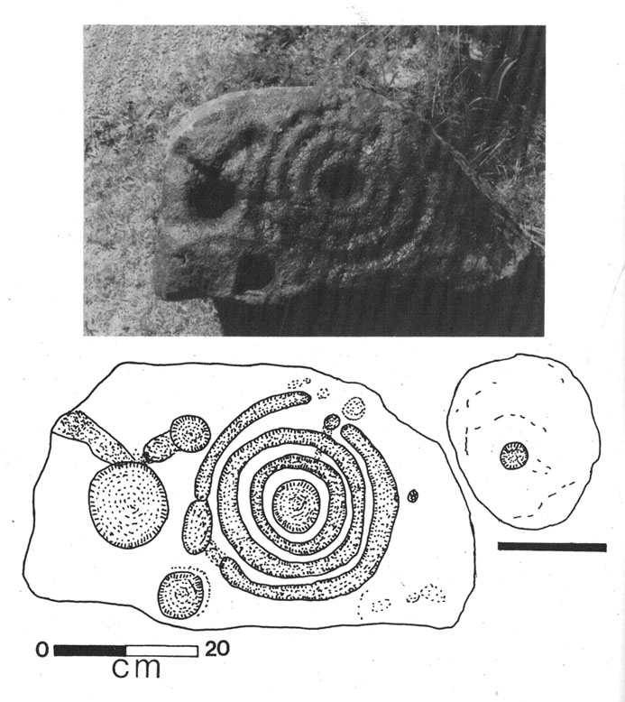
Photo & drawing of Dean’s cup-and-ring (after Beckensall, 1992)

St Oswald’s church stands at the western edge of the village of Dean beside the road to Branthwaite. The village is located some 5 miles due south-west of Cockermouth and about 6 miles to the south-east of Workington.

Archaeology & History

In the nave of St Oswald’s church there is now housed a small sandstone boulder that has a well-defined central cup-mark around which are two large concentric rings, a third ring being left open – perhaps indicating a portal (gateway), and three other well defined cup-marks at the side of that, one of which has become almost adjoined to the other through erosion.

The boulder was ploughed up in a field at nearby Park Hill to the south-west of the village in 1918. It was then placed in the churchyard but, in recent times it was brought into the church for safety reasons.

References:

  1. Beckensall, Stan, Cumbrian Prehistoric Rock Art, Abbey Press: Hexham 1992.
  2. Beckensall, Stan, British Prehistoric Rock Art,Tempus: Stroud 1999.
  3. Beckensall, Stan, Prehistoric Rock Art in Cumbria, Tempus: Stroud 2002.

© Ray Spencer, 2011


Chapel Flat, Dalston, Cumbria

Stone Circle (destroyed):  OS Grid Reference – NY 37 50

Archaeology & History

Listed in Burl’s (2000) magnum opus, this is another long-lost megalithic ring, whose exact location seems to have been forgotten.  An early description of the site by William Whellan (1860) told us that,

“There was formerly a circle of rude stones, ten yards in diameter, near the village, supposed to have been the remains of a Druidical temple; and a little distance from it, was a tumulus, three yards high and eight in diameter.”

More than a hundred years later in Waterhouse’s (1985) fine survey, he described the circle, saying:

“It lay near the village of Dalton…near the River Caldew… An 18th century account describes it as consisting of ‘rude’ stones…set in a circle of diameter about 27m.  East of the the centre of the circle were four large stones lying on top of each other.  They may have been the remains of a cist, or possibly a tumbled cove, like that inside the circle-henge of Arbor Low in Derbyshire.  A tumulus may have stood nearby.”

There are however some discrepancies in the descriptions between Whellan and Waterhouse.  In the former, the site of Chapel Flat is talked of separately as being the abode of a hermit in the lost chapel of St. Wynemius, “in a deep and romantic part of the vale of Caldew.”  The description of the stone circle immediately follows this, but is spoken of as merely being “near the village.”

Does anyone know anything further about this once important site?  Did the lost hermitage on Chapel Flat actually have anything to do with the stone circle?

References:

  1. Burl, Aubrey, The Stone Circles of Britain, Ireland and Brittany, Yale University Press 2000.
  2. Waterhouse, John, The Stone Circles of Cumbria, Phillimore: Chichester 1985.
  3. Whellan, William, The History and Topography of the Counties of Cumberland and Westmoreland, Comprising their Ancient and Modern History, W.Whellan: Pontefract 1860.

© Paul Bennett, The Northern Antiquarian

Old Market Cross, Sedbergh, Cumbria

Cross (destroyed):  OS Grid Reference – SD 6573 9212

Archaeology & History

More than 150 years ago outside St. Andrew’s Church in Sedbergh, A.E. Platt wrote (1876) that,

“there was a cross standing in the Market Place adjoining the churchyard on the north, but the last remains of it, and the stone steps it stood on, were taken away some years since by private persons, and may now be seen used as gateposts to a farmyard, some ten miles from their original position.”

Intriguing stuff!  Does anyone know which farmyard might still possess these old relics?  When the legendary Harry Speight (1892: 443) ventured by here fifteen years later he knew little about their new location, but simply echoed what Platt had previously written.  It would be good to know what has become of them…

References:

  1. Platt, A.E., The History of the Parish and Grammar School of Sedbergh, Yorkshire, Atkinson & Pollitt: Kendal 1876.
  2. Speight, Harry, The Craven and Northwest District Highlands, Elliot Stock: London 1892.

© Paul Bennett, The Northern Antiquarian

St. Cuthbert’s Well, Waverbridge, Cumbria

Holy Well:  OS Grid Reference – NY 21479 48615

Also Known as:

  1. Haly Well
  2. Helly Well

Getting Here

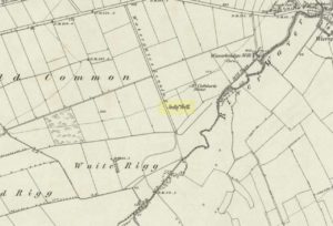
St Cuthberts Well on 1868 map

A mile east of Waverbridge, turn down the track called Watergates Lonning. Before you reach the bottom, on the left side of the straight track is a spring of water. This is the old holy well.

Archaeology & History

Although much used in bygone times, very little of it can be seen nowadays.  When John Musther (2015) wrote about it recently, he told that although it was

“Once known for its copious amount of remarkably pure and sweet water, it is now only a trickle by a tree.”

Nearly three hundred yards away across the fields northeast of this small spring of water, was once seen “a pretty large rock of granite, called St. Cuthbert’s Stone“, whose mythic history will have been intimately tied to the holy well.

Folklore

In the second volume of William Hutchinson’s History of the County of Cumberland (1794), he tells that the St. Cuthbert’s Well,

“is a fine copious spring of remarkably pure and sweet water which…is called Helly-well, i.e. Haly or Holy Well. It formerly was the custom for the youth of all the neighbouring villages to assemble at this well early in the afternoon of the second Sunday in May, and there to join in a variety of rural sports. It was the village wake, and took place here, it is possible, when the keeping of wakes and fairs in the churchyard was discontinued. And it differed from the wakes of later times chiefly in this, that though it was a meeting entirely devoted to festivity and mirth, no strong drink of any kind was ever seen there, nor anything ever drunk but the beverage furnished by the Naiad of the place. A curate of the parish, about twenty years ago (c.1774), on the idea that it was a profanation of the Sabbath, saw fit to set his face against it; and having deservedly great influence in the parish, the meetings at Helly-well have ever since been discontinued.”

References:

  1. Hutchinson, William, The History and Antiquities of the County of Cumberland, volume 2, F. Jollie: Carlisle 1794.
  2. Musther, John, Springs of Living Waters: The Holy Wells of North Cumbria, J.Musther: Keswick 2015.

© Paul Bennett, The Northern Antiquarian


Rawthey Bridge, Fell End, Ravenstonedale, Cumbria

Stone Circle (destroyed):  OS Grid Reference – SD 714 978

Archaeology & History

This is yet another stone circle that’s been destroyed. It seems to have been described first by Nicolson & Burn (1777) — as “a circle of large stones, supposed to be a monument of druid worship” — but a century later when Reverend Nicholls (1877) came to describe it, he was talking of it in the past tense, saying:

“Fifty years ago there was a circle of stones on the high road leading from Kirkby Stephen to Sedbergh, near Rawthey Bridge, supposed to be a monument of Druid worship.  These stones, I have been informed by Mr. William Alderson of Brigg, were blocks of limestone, about three feet high, and were inconsiderably removed for the purpose of helping to build the abutment on the Ravenstonedale side of the present bridge which spans the Rawthey, and bears (the) date 1822.  The holes in which the stones stood are, however, yet visible, although overgrown with grass.  Collectively they form a circle.”

One writer later (1967) told that the site “seems to have stood on the moor to the left of the road opposite the confluence of the Sally Beck with the Rawthey.”  As far as I’m aware, little more is known of the site. Omitted from Burl’s magnum opus, it was included in Waterhouse’s (1985) fine survey of Cumbrian megaliths, but with no further details.  But another Victorian writer (Thompson 1892) thought it more likely that the ‘circle’ here was, in fact, more likely a barrow or grave-mound.  Sadly, we’ll probably never know…

References:

  1. Anon., Sedbergh, Garsdale and Dent, Reeds: Penrith 1967.
  2. Nicholls, Rev. W., The History and Traditions of Ravenstonedale, John Heywood: Manchester 1877.
  3. Nicolson, J. & Burn, R., The History and Antiquities of the Counties of Westmorland and Cumberland, London 1777.
  4. Thompson, Rev. W., Sedbergh, Garsdale and Dent, Richard Jackson: Leeds 1892.
  5. Waterhouse, John, The Stone Circles of Cumbria, Phillimore: Chichester 1985.

© Paul Bennett, The Northern Antiquarian