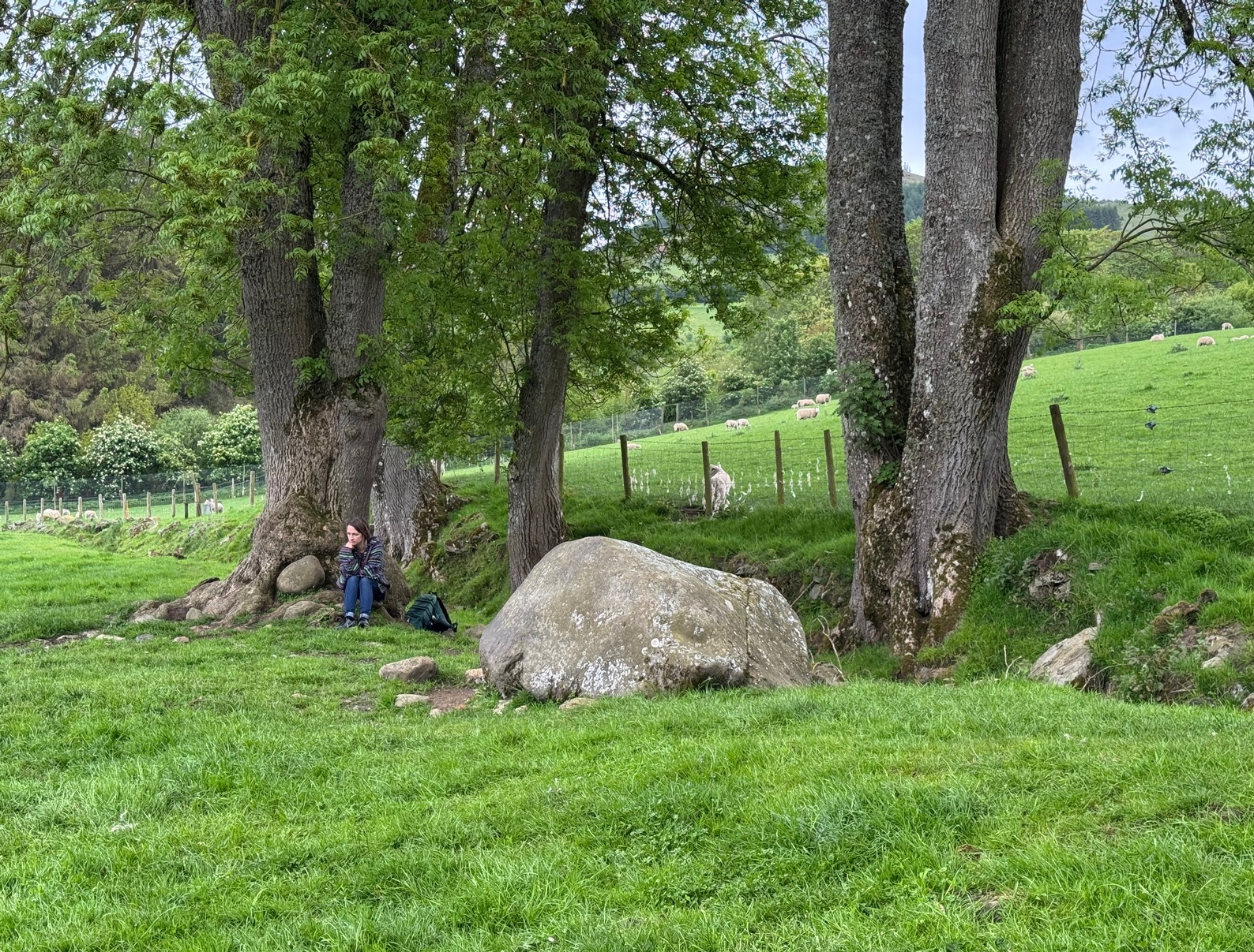
Various ways to get here, but it’s probably easiest if you’re coming via Aberfeldy. From here, go over the river bridge to Castle Menzies and Weem, but turn right once you’ve crossed the bridge and follow the road parallel to the river for just over 3 miles (4.9km) where you’ll reach a tiny road on your left, going uphill. You can park the car 150 yards up, on your right – then walk uphill (don’t drive any further). Walk up the road for just over half-a-mile (0.95km) and take the right turn; go along here for 300 yards where the pond appears and keep walking along the same road for another 250 yards till you reach a cottage by a small crossroads. From here, walk up (left) for another 300 yards where, near the top of the field, a large boulder sits close to the fence. You’ve arrived!.
Archaeology & History
Drumchanachan carving
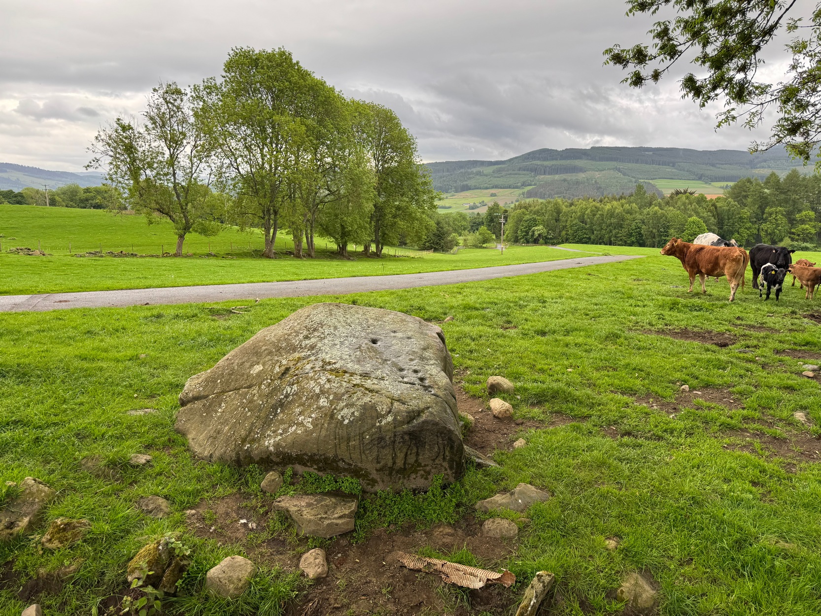
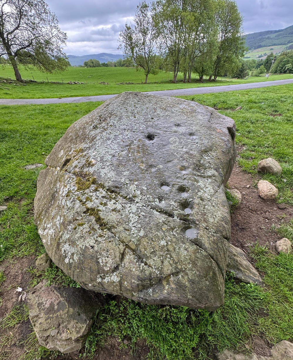
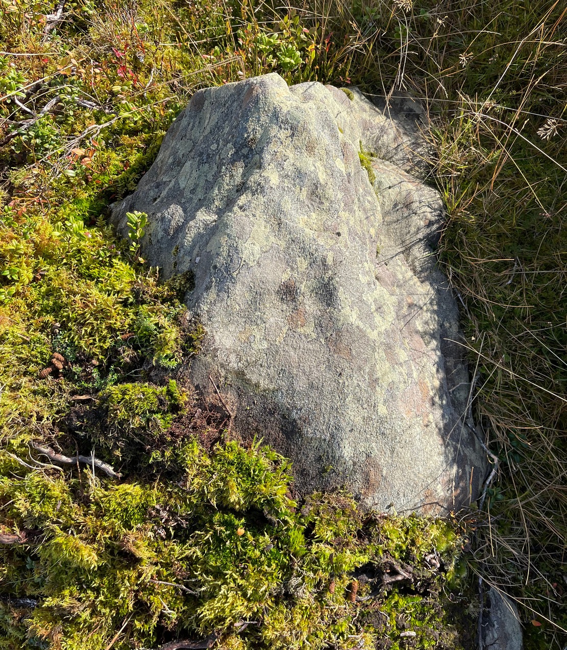
On the way back down from a bimble to the beautiful and haunted Loch Derculich, Naomi and I stumbled upon this large stone just off the track below Lurgan farmhouse and found there to be a number of cup-marks on its sloping upper surface. Naomi was really truly excited! 🙂
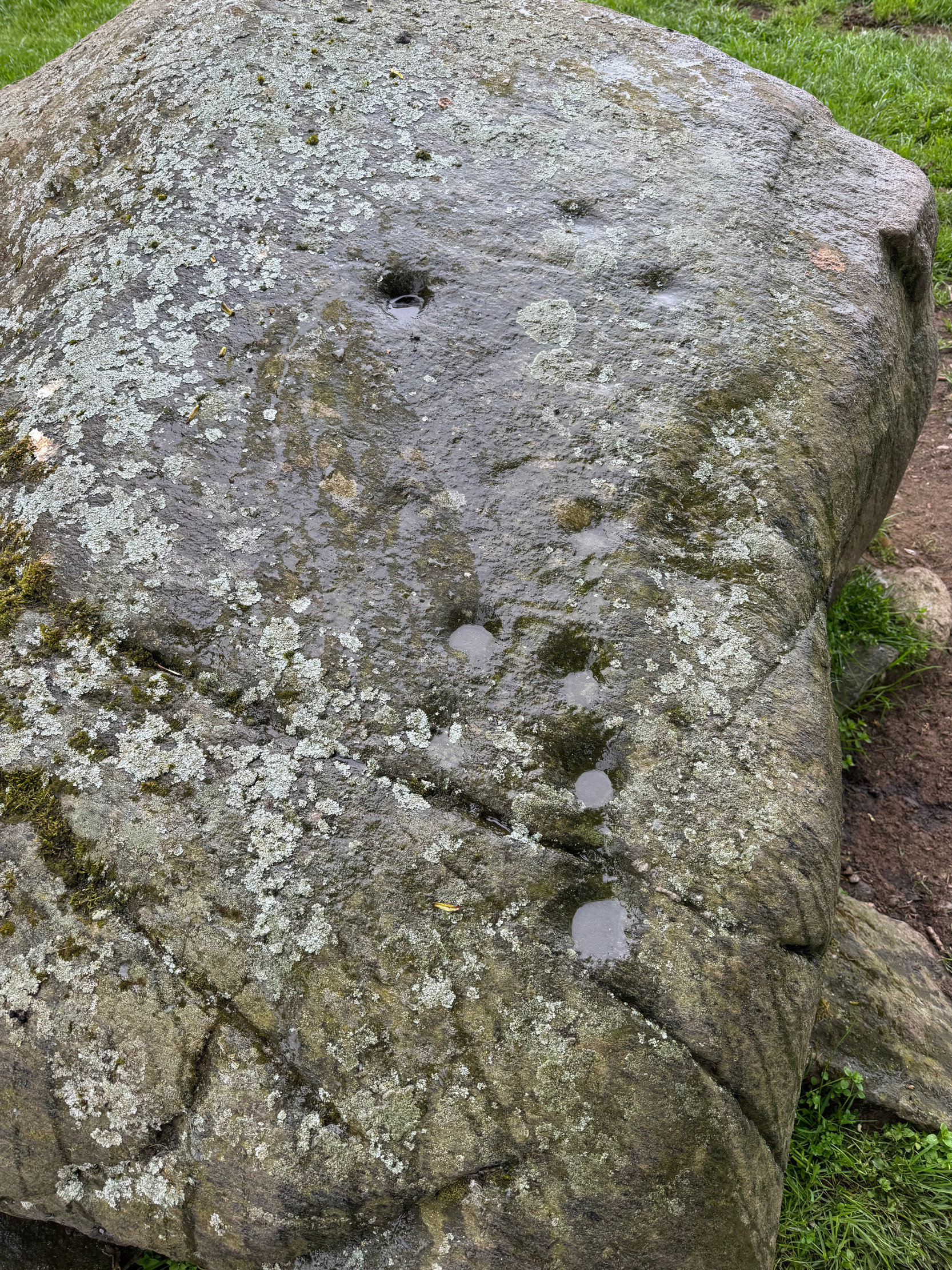
On its northwestern surface there’s is a distinct scattering of cup-marks: one in particular near the middle of the stone that’s been deepened in more recent times, as if it was ready to be blown-up and destroyed but, once realised it was a stone of the fairy folk, the operation was terminated and the stone left here to live! Thankfully…
Close-up of cupsDeep lines of cups
It’s a pretty basic design, consisting of at least eleven cup-marks, mainly running in a line upwards along its westernmost side, following the edge of a natural ridged contour. Of the two topmost cups, one of them may have a carved line running to it with a faint semi-circle then emerging from the line around the edge of the cup. But it’s faint—if it’s real—and the daylight was fading when we came here so this and any other design elements that may exist weren’t too easy to see. Hopefully I’ll get back up here pretty soon and see if there’s anything else hiding beneath the aged shadows.
It’s a wonderful arena above Edradynate, with countless other ancient sites peppered across the landscape hereby…
Cup-and-Ring Stone (lost): OS Grid Reference – NY 5019 2776
Also Known as:
Archaeology & History
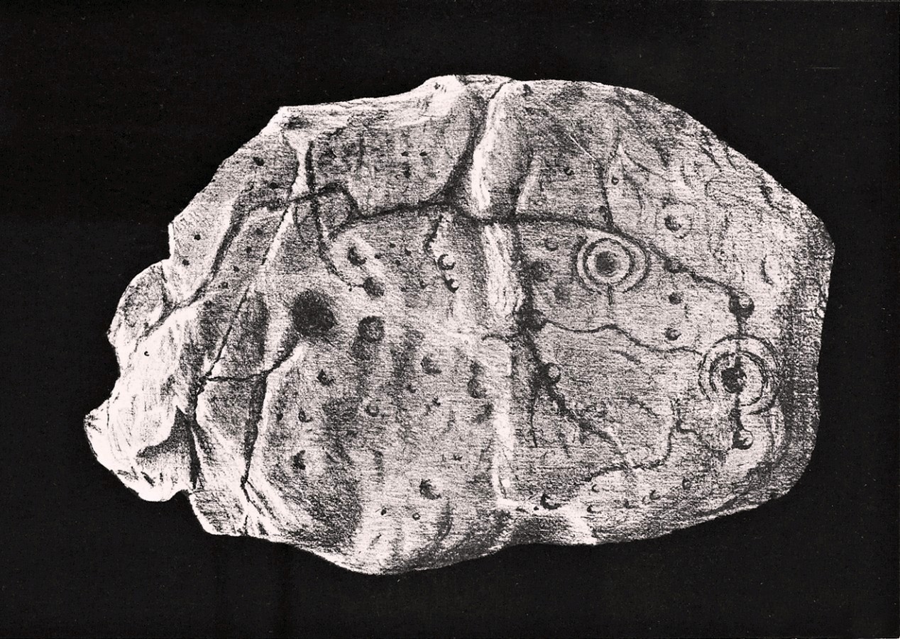
Taylor’s 1883 sketch
The geographical position of this site was shown on the 1897 Ordnance Survey map, albeit in the past tense as it had been destroyed not long after after being uncovered. Thankfully however, local antiquarian Mick Taylor (1882; 1883) did a damn good job recording what had been found here, and although he had remains of the stone in his possession shortly after it had been found, the carving has subsequently been lost. Thankfully Mr Taylor left us with a good drawing of the design (right).
Located a short distance west of the grand henges of Mayburgh and King Arthur’s Round Table, the carving was found some ten inches below the ground during work that was being done to lay some new fencing. The lads doing the work hit some stone and found it to be covered with a number of standard cup-and-ring motifs facing downwards. This carved stone, wrote Taylor (1882), was in fact “the cover of a kist-vaen”, a.k.a, prehistoric stone burial cist. He then proceeded to give a lengthy account of the site and the carving, telling:
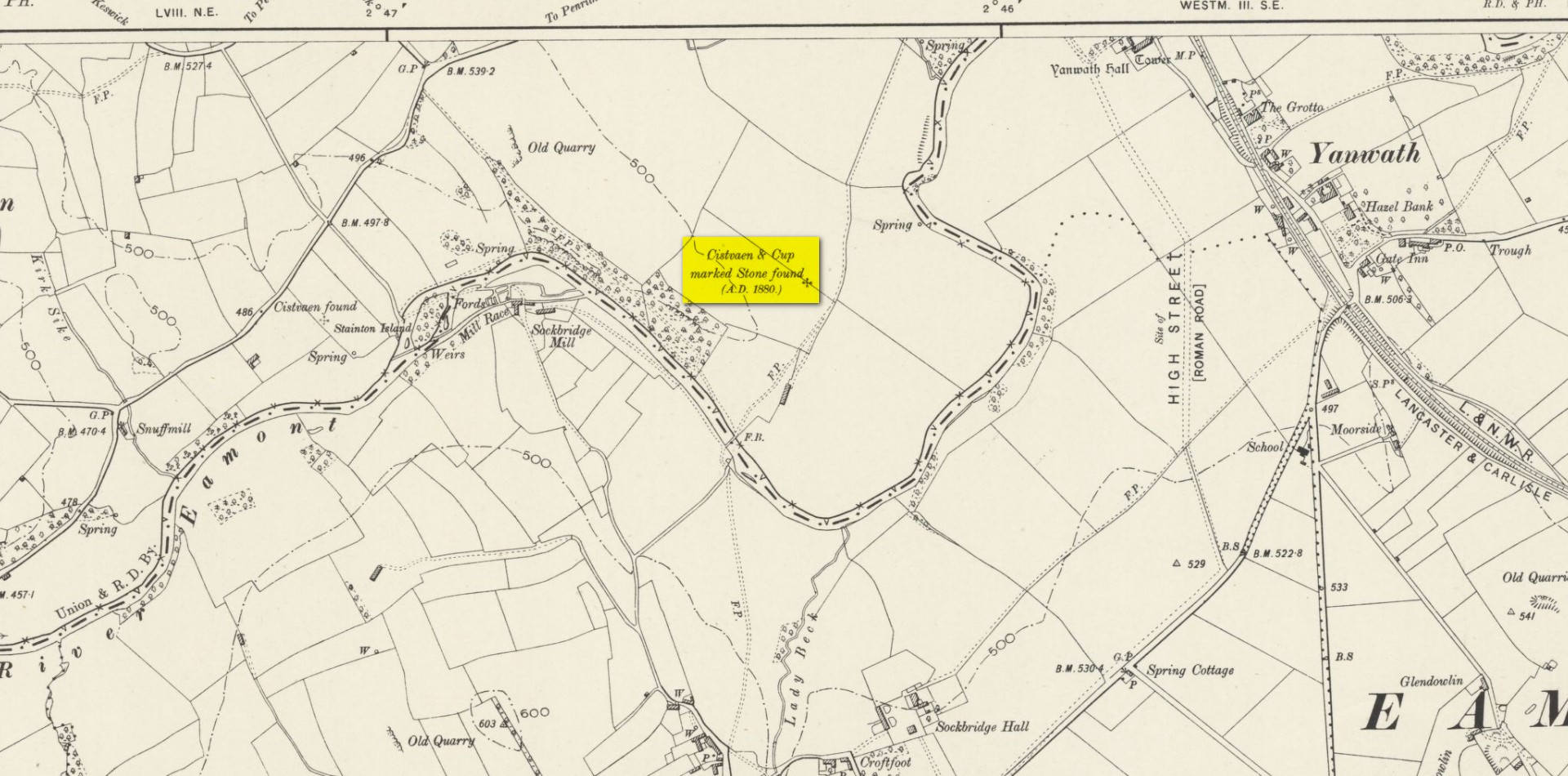
Site shown on 1897 map
“There are traces of ancient occupancy, and vestiges of cairn structure still to be discerned on the hill-side on which it was found, but no barrow nor mound covered this particular grave. A space had been excavated for the interment dipping into the limestone rock to a depth of about 3 feet; the length of the grave was 4 feet, and the breadth about 3 feet 6 inches. Cobble stones had been used partially to line the cavity, but there was no flagging at the sides or bottom. The space was filled with blackish soil, amid which was a quantity of burnt bones, all in a fragmentary state. No implement nor shreds of pottery could be found, but there were several pieces of charcoal. It had evidently been an interment of cremated remains.
“The massive stone which formed the cover of the kistvaen I saw in situ immediately after its discovery.
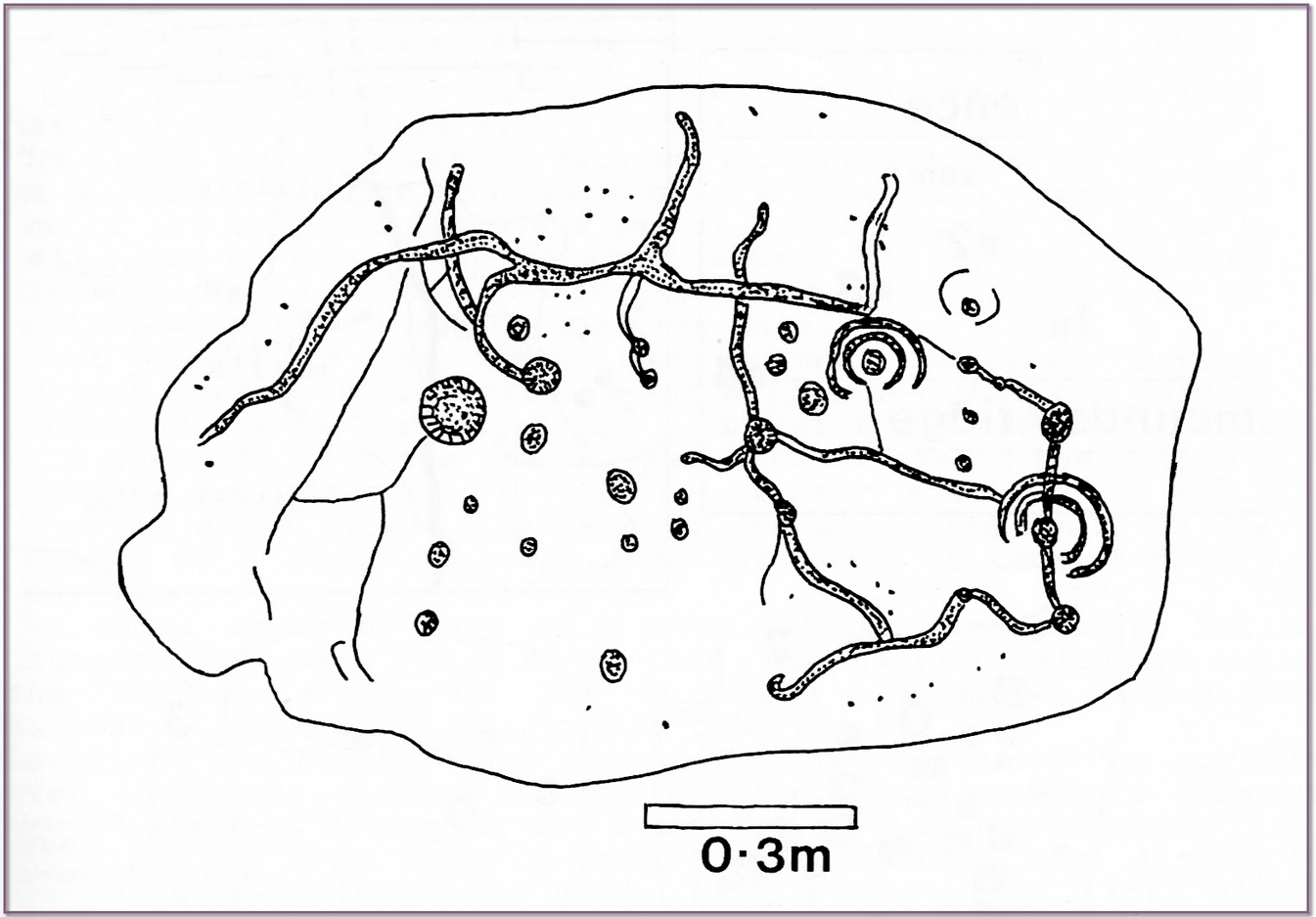
Beckensall’s impression of the design
“This stone is a natural slab of white freestone; it is of a broadish ovoid form, 5 feet 4 inches long, and at the centre 3 feet 6 inches broad, tapering towards each end; and it varies from 8 inches to 13 inches in thickness. The superior surface is rough and irregular, and scored in many places with marks of the ploughshare and harrows, which have passed over it in frequent cultivation. The interior surface, which was presented towards the grave, shows a fairly smooth cleavage, and on it were carved the sculptured markings which I shall describe.
“The slab, which is in my possession, was unfortunately broken in three or four pieces by the hammer of the workman, but I have put it together, and when viewed with a certain light when the shadows are deep, the sculpturings may be well made out, and appear to be arranged as follows: near the bottom there is a central cup deeply carved, about 3 inches in diameter; around this there are two concentric rings, somewhat faintly incised, the outermost of which has a diameter of 6 inches. From this central cup proceed two grooves 6 inches long, which bisect the concentric circles, and traverse in a straight line to join a similar cup on each side of the central one. From this line of cups three gutters meander upwards over the surface of the slab; the main channel takes a direction upwards on the right side of the stone, and receives a number of branches like the tributaries of a river from each side, and terminates on the free margin of the upper part of the stone. On the lowest quarter of the stone to the right there is a large hollow cup 3 inches in diameter, around which also there are two well-executed concentric rings, the largest with a diameter of 6 inches. These rings are cut by a radial groove which joins a gutter in the centre of the stone, and in the opposite direction, at a point in their circumference, they fall into and are subtended by the larger side channel. These are the only two cuttings on the stone which present this annular arrangement; on the other hand, the simple cup markings are numerous, in fact, twenty-four may be counted. One of these cups is greatly larger than any of the rest. It is situated in the centre of the upper half of the slab, and on first view forms the most strikingly characteristic feature of the tablet. This cup is 6 inches in diameter, and is carved out to the depth of 3 inches. The chisel marks are distinct and fresh, as if done yesterday; and there is a smoothness and regularity of execution about it, which evinces that more pains have been taken with it than with some of the other incisions. The other cup-markings vary from 1 inch to 3 inches in measurement. A number of them (about twelve of them may be counted) are associated with the furrowed lines, either forming the beginning of a gutter, or joining or being included in the line of the channel itself. These form the series of the larger cup-markings, and are an inch or more in depth. On the other hand, others of these cups are isolated, and scattered singly, and apparently without regular order over the surface, and unconnected with the branch-like lines; these for the most part are mere shallow depressions, and with less defined margins. Again, there is another class of markings on the stone; they are very numerous, and are dispersed apparently irregularly over all the surface; these are little pits or pick marks, small irregular holes picked into the stone, evidently done with some pointed tool.”
Taylor thought that these “small irregular holes” had been made with a flat-edged chisel whacked with a hammer, and the cup-marks “by a flint or harder stone.” In examples I’ve found in Perthshire where the tools have been left at the site, both a harder stone was found at one (for some reason actually laid within the cup-mark and left there before it had been finished), whilst a flint was laid in the cup-mark of another carving (although that example seemed to be more a deliberate deposit rather than being the tool that made the carving).
Anyhow, considering the poor condition of the carving when Taylor described it—”broken in three or four pieces”—there’s little likelihood of it having survived. But, on the off-chance that someone’s mum or granny has it hiding in the rockery at the back of the garden somewhere, give us a shout….
References:
Beckensall, Stan, Cumbrian Prehistoric Rock Art, Abbey Press: Hexham 1992.
Beckensall, Stan, Prehistoric Rock Art in Cumbria, Tempus: Stroud 2002.
Taylor, Michael W., “On a Sculptured Stone with Cup and Ring-Markings, found at Redhills, near Penrith,” in Proceedings Society of Antiquaries Scotland, volume 16, 1882.
Taylor, Michael W., “On a Cup-marked Stone found at Redhills, near Penrith,” in Transactions Cumberland & Westmorland Antiquarian & Archaeological Society, volume 6, 1883.
Acknowledgements: Huge thanks for use of the Ordnance Survey map in this site profile, reproduced with the kind permission of the National Library of Scotland.
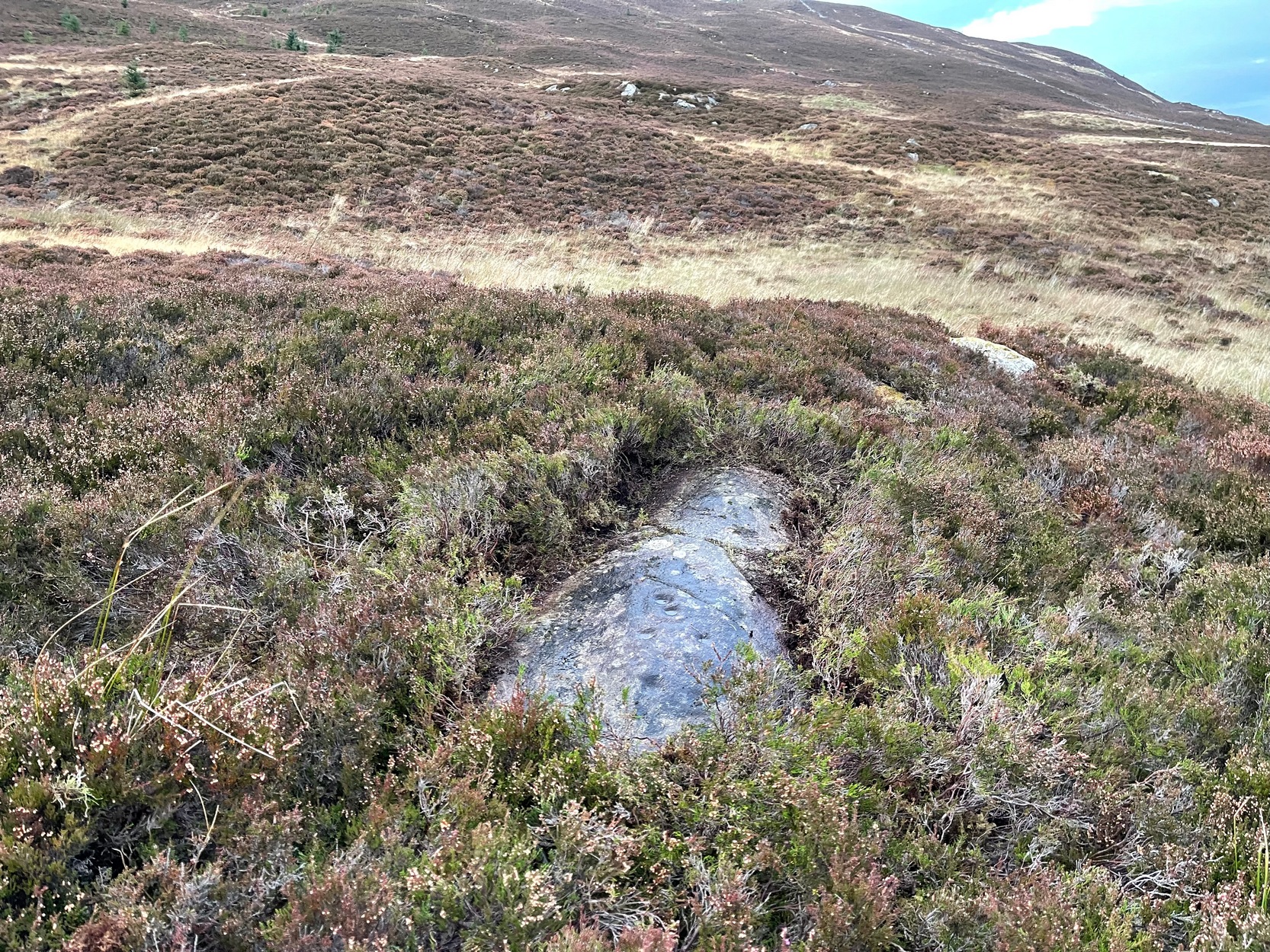
Like many of the Craig Hill carvings, this takes some finding when the heather’s deep… If you can locate the Craig Hill hut circle (there are actually several of them close to each other), face uphill (looking at the trees) and then from the hut circle walk diagonally to your right (northeast) and walk up the slope for 30-40 yards. A large boulder is in front of you and, just past it at the edge of a small rock-face, a fallen tree is your marker. Just a few yards above and past this is an earthfast elongated stretch of rock. You’ll find it…
Archaeology & History
Some cups & 2-in-a-ring
On my visit to this carving I arrived near the end of the day. Within the hour, beneath an already cloudy grey sky, night had fallen; and so, obviously, my assessment of this carvings design was somewhat hampered…
It’s one of several quite separate petroglyphs that almost collide with each other on adjacent rock faces. Etched across this, an elongated slightly convex stone, we find a series of cup-marks in no particular order, mainly running along the topmost section of the stone. Others fall away at the edges, with what seemed like one or two at the more northeastern end of the stone. However, due to the poor lighting when I came here, I struggled to make out the full design and so probably missed some important elements. I’ll update this if/when I visit it again – or if a fellow antiquarian visits the spot and sends in some good images.
From Kenmore village, just as you’re going out of the village towards Aberfeldy (A827 road), turn right as if you’re going on the minor road on the south-side of Loch Tay. Almost immediately on this road, turn left and take the tiny, steep road uphill towards Amulree. After 2½ miles uphill, the road begins to level out and a small loch is on your left (north). Just past it, on the same side, a track runs onto the moors. Walk along here for nearly a mile where the track splits: keep to your left and the track follows the line of walling. Now’s the hard bit: after literally ⅔-mile, walk downhill and cross the burn (stream), then less than 50 yards up the slope on the other side, zigzag around…
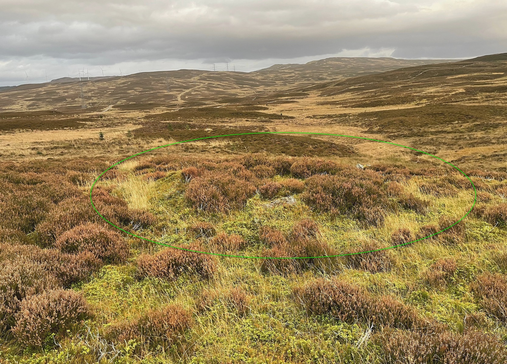
Archaeology & History
Craig Hill circle looking SW
Overlooking a small (unnamed) burn immediately to the right and a large wide marshy hollow to the front, is this small and seemingly singular hut circle, in a good state of preservation, surrounded by the scattered mass of cup-and-ring stones—some complex, some very plain—all over this moorland slope. It’s a very long journey to take just to visit a single hut circle, but I’d assume that you’d be wanting to see the petroglyphs surrounding it too—so mebbe have a look at this whilst you’re fondling the rock art!
Internally this is quite a small circle, measuring barely 5 yards (east-west) by 6 yards (north-south), seemingly with its entrance on the north. Its small size suggests it was constructed for the use of just one person; two at the very most. The structure is still in very good condition considering its age (possibly Bronze Age), with minimal damage apart from Nature’s wind and weathering. The circle is made up primarily of a number of large rocks with many filling stones, with the walling being a yard or so wide all round. In all likelihood, the rest of the building would have been made of timber, with a typical tented roof. It’s an excellent spot to base yourself to explore all the cup-and-ring stones on these slopes. Perhaps, just perhaps, this might have been a shaman’s hut, looking over the ancestral images on the rocks hereby…. ♥
Take the long steep zigzag road from Kenmore to Amulree, and just where the road begins to level out, park up near the isolated hut by the roadside at the side of the lochan. Just past here, a track on your left takes you onto the moors, past the lochan. Nearly a mile along the track splits: bear to the right, uphill slightly, then it’ll wind downhill and you’ll pass another track on your right. Ignore it, keep walking along and where you find a grassy little passing-place on your right—stop! Now walk uphill, onto the moor, through the heather for 175 yards and the land has levelled out. Look around!
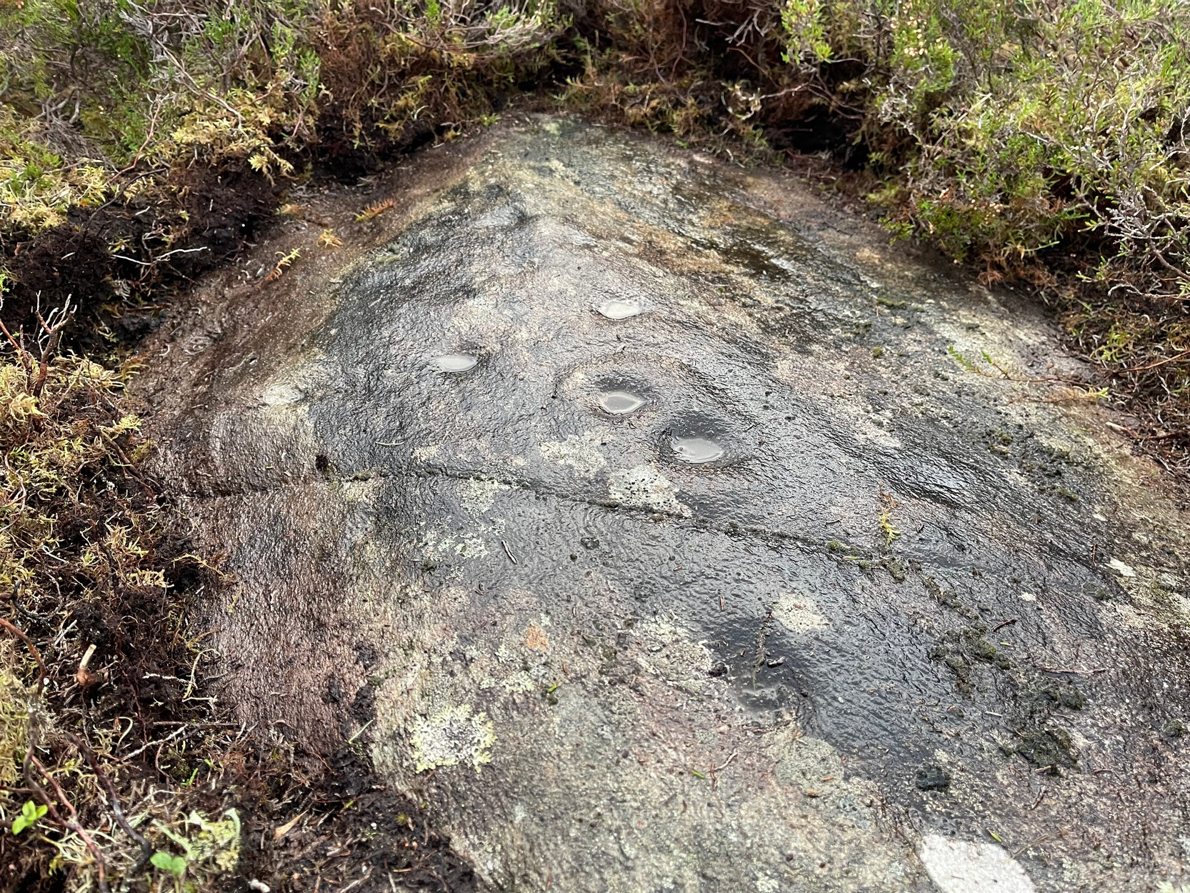
Archaeology & History
Cupmarks from above
I came across this very basic carving when checking out a couple of others close by and found that it hadn’t been recorded before. It’s nothing special to look at, but is an outlier of the main Craig Hill cluster of carvings a few hundred yards to the west. The design consists of at least two cup-marks that have been etched near the top of the rock, although when I wet the stone it seemed as if a third one was next to the other two, as if in a line. The sun was at its peak when I found it, which meant that I couldn’t get any decent photographs to illustrate this—even when I watered the olde thing! It’s another carving that will only be of interest to the real petroglyph fanatics amongst you.
Cup-Marked Stone (destroyed?): OS Grid Reference – NN 8575 4901
Also Known as:
Clachmore
Archaeology & History
The Clach Mhor, or the Big Stone, is all but forgotten as an antiquarian relic in Aberfeldy. It’s history is somewhat piecemeal. First described in Hugh MacMillan (1884)’s essay on local cup-and-ring stones, he told that:
“A short distance above the village of Aberfeldy, where General Wade’s old road emerges from the houses, a huge stone, called the Clach Mhor, lies on the left-hand side in a slanting position half erect, as if supported by the garden wall of which it forms a part. …In all likelihood it originally stood erect, and formed one of a group of similar stones, its companions having been broken up in the formation of the road. …On the upper face there are some small cup-markings, not quite so well formed as usual, owing to the hardness of the material… The fact that they occur on only one side of the stone, and are scattered indiscriminately all over its surface, are sufficient to convince any one who is skilled in the subject that they are genuine specimens of prehistoric sculpture.”
Nearly thirty years after this initial description, MacMillan (1901) found that it had previously been a part of The Tullich stone circle, and following its destruction the Clach Mhor was moved and used as “part of a garden wall on the old military road passing along its base.”
More than fifty years later, the Aberfeldy historian N.D. Mackay (1954) told that up to 1910 the Clach Mhor was a conspicuous object, standing “as it were overlooking and to some extent overhanging the roadway down near the Square.” However, it
“was blasted and broken up in 1910 in the course of road widening operations, but a considable part of it was built into, and still forms the lower corner of, the garden boundary wall, nearest The Square, of the house which bears its name, ‘Clachmhor’. Its present position is slightly east of the site it occupied when I first knew it and, unless Wade’s men did actually move it, the site it occupied for centuries.”
Mackay also mentioned what he called the “indentations” on the stone which MacMillam deemed as cup-marks, but he pointed out that one Rev. John MacLean “believed they were made by the levers, jacks, etc, of (General) Wade’s men” when they cut the road into Aberfeldy in the 18th century, whilst
“A third solution was given by the son of a one-time local strong man called Big Robert, “What a strong man my father was,” he said, “he lifted that stone. Don’t you see the marks of his fingers on it?””
It’s not known what became of the Clach Mhor and whether it remains hiding in some walling, or whether it has met its demise….
References:
Mackay, N.D., Aberfeldy Past and Present, Town Council: Aberfeldy 1954.
Cup-Marked Stone (lost): OS Grid reference – NN 918 524
Archaeology & History
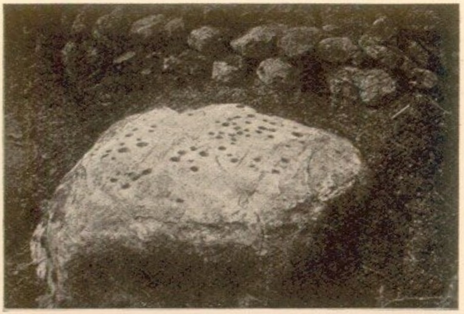
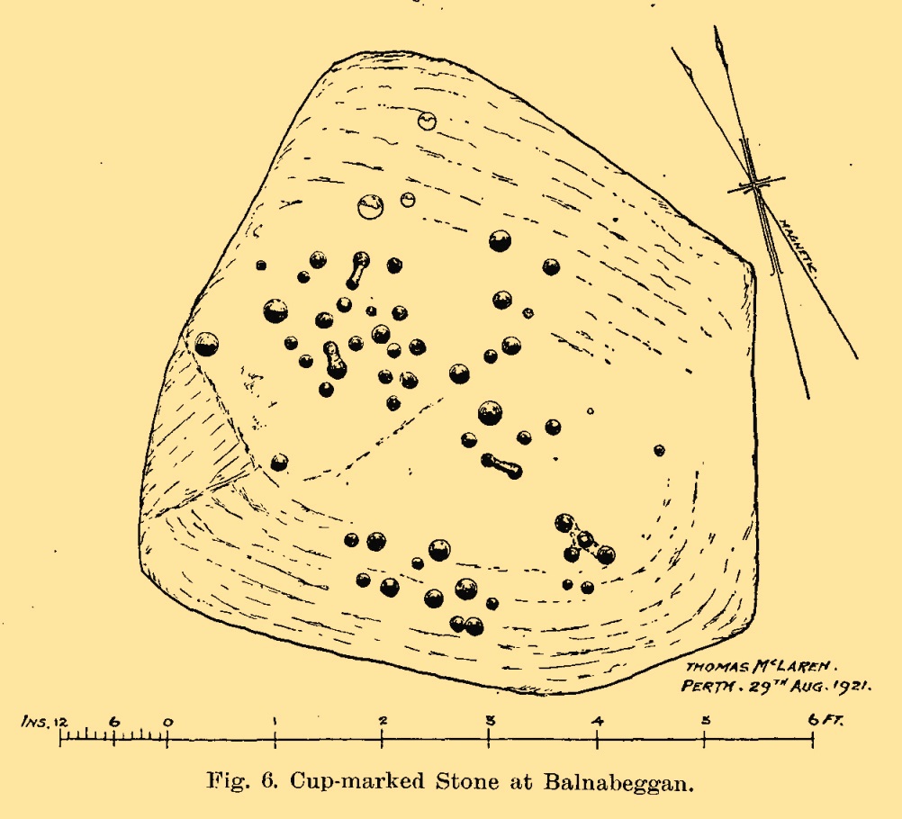
On the hillside a short distance (probably) south of old Balnabeggan farmhouse, up against some walling at the edge of some natural birch wood, could once be seen—some fifty or sixty years ago—a large, ornately inscribed, quartz-enriched cup-marked stone. And, although seemingly lost, it shouldn’t be too hard to uncover with a little bit of bimbling and dedication. It was described in some considerable detail in John Dixon’s (1922) survey of the Strathtay petroglyphs as being,
Balnabeggan stone, c.19201921 sketch of the stone
“roughly hexagonal in shape, but one side is partly hidden by an old dry-stone wall built above it. The greatest width is 7 feet, whilst a diameter at right angles measures 6 feet. The thickness or depth of the stone is at least 2 feet, but it may be more underneath, as the stone stands in a wet place in which it may have settled down.
“On the upper surface of the stone are fifty-nine cups of various sizes, the largest measuring 2½ inches in diameter, and from 1 inch to ½ inch, or less, in depth. A special feature is that four equidistant cups (three in a row and the fourth at a right angle to the centre of the row) are connected by grooves slightly less broad and deep than the cups. Three pairs of cups are also similarly connected. The cups connected as described are discernible, but the group of four cups on the low left side of the stone does not appear in the photograph to have its fourth cup (the lowest) connected, as it really is, with the central cup of the group.”
Mr Dixon’s additional clue as to its whereabouts is that it’s “about 500 feet above sea level.” So what, pray, has become of it…?
References:
Dixon, John H., “Cup-Marked Stones in Strathtay, Perthshire,” in Proceedings Society Antiquaries, Scotland, volume 56, 1922.
Kennedy, James, Folklore and Reminiscences of Strathtay and Grandtully, Munro Press: Perth 1927.
Cup-Marked Stone (lost): OS Grid reference – NN 8866 5320
Also Known as:
Sunday Well
Tobar an Donich
Archaeology & History
Tobairandonaich stone, c.1920
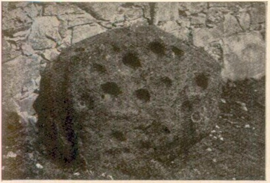
Located some 30 yards south of a holy well known (in English language) as the Sunday Well, this carving was rediscovered shortly before John Dixon (1922) wrote his survey of petroglyphs in the Strathtay region. It would seem to have been a large “portable” cup-marked stone that had been placed, face-downward, into an old doorstep at the stable at Easter Tobairandonaich and forgotten about, long long ago. Then, at the beginning of the 20th century when the people living here had to clear a drain beneath the stable, the stone was moved and the cup-markings were noticed. The carving was a pretty simplistic design, as you can see, which was described by Mr Dixon as follows:
“The stone…has nineteen cups all on the same face. The largest cup is 3¾ inches in diameter and 2 inches deep. The next largest has the same diameter, but is 1½ inch deep. Other five of the cups are very nearly the same size. The smallest cup is 1¾ inch in diameter and ½ inch deep, but weathering has effected much towards almost obliterating some of the smaller cups. The stone is of whinstone with slight veins of quartz. It is oval in form and varies in thickness from 2½ inches to 4 inches. Its greatest diameter is 3 feet 2 inches, and its least diameter 2 feet 8 inches.”
Tom MacLaren’s 1921 sketch
The stone would seem to have disappeared as no one has seen it for fifty years or more. It may (hopefully) be in one of the walls, or perhaps buried somewhere under the soil. Or maybe, tragically, some fuckwit has destroyed it. Twouldst be good to find out one way or the other. The photograph above, taken by Mr Dixon sometime around 1920, is the only thing that remains of the carving.
In this small part of Strathtay we are fortunate in finding a cluster of petroglyphs with folklore about them relating to our faerie and witch folk. Some larger man-made stone “bowls” in the area were also used as “praying stones.” I have little doubt that the people who originally used this carving as a doorstep were fully aware of the cup-marks—and I’d suggest that they even put it here on purpose, probably as a form of protection from the fairies who might have stolen or caused sickness to the horses.
References:
Dixon, John H., “Cup-Marked Stones in Strathtay, Perthshire,” in Proceedings Society Antiquaries, Scotland, volume 56, 1922.
Kennedy, James, Folklore and Reminiscences of Strathtay and Grandtully, Munro Press: Perth 1927.
Yellowlees, Walter, Cupmarked Stones in Strathtay, Scotland Magazine: Edinburgh 2004.
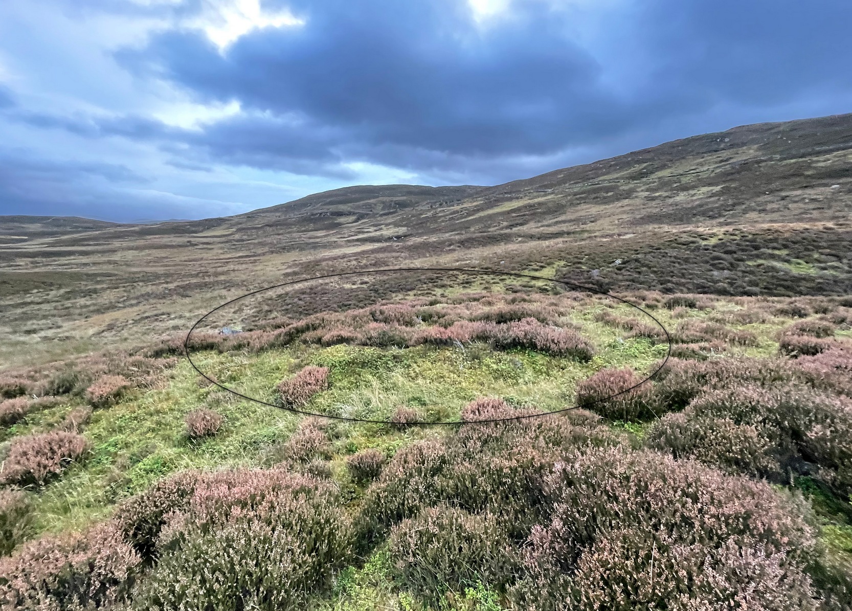
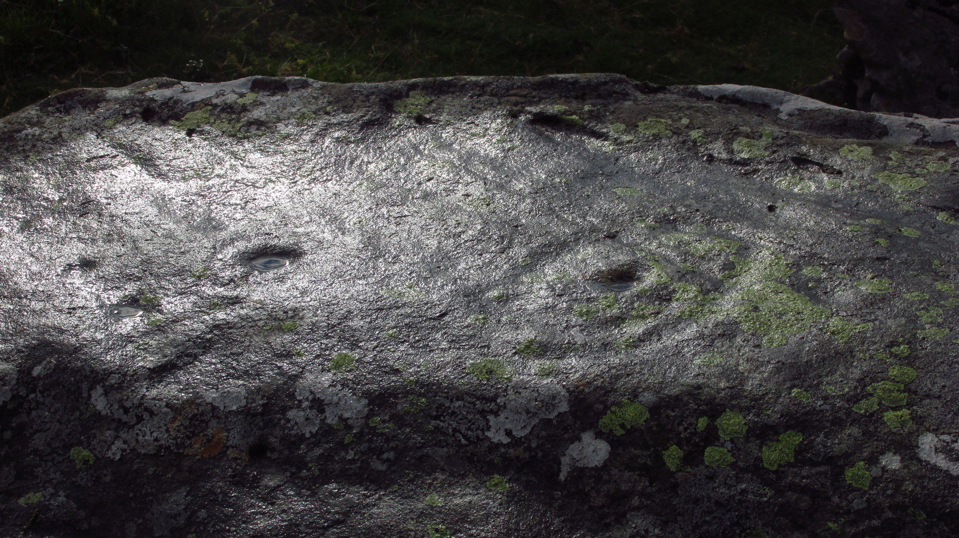
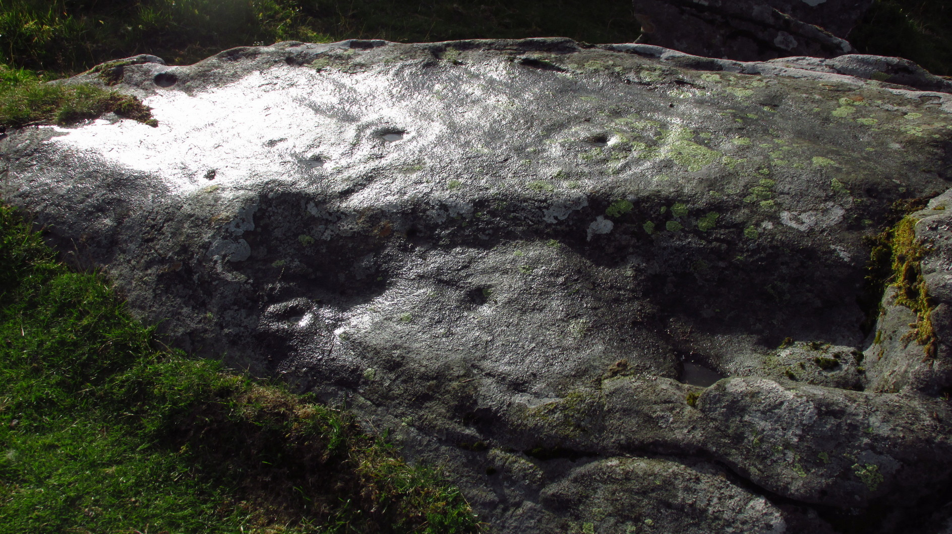
From Kenmore go east up the steep mountain road towards Glen Quaich, or if you’re coming from Amulree, go west along the same glen. After 2½ miles (4km) up the Kenmore route (nearly 9 miles on the Amulree route) you’ll reach a small lochan on your left (you’ve got a very small parking spot a coupla hundred yards before the loch). A gate and stile past the loch takes you east along a track into the moors. More than a mile on, the track splits, but you need to keep to the left and follow the track along the wall-side for another 400 yards or so, where you’ll see a small crag of rocks 100 yards down the slope on your right. Once here, the deformed triangle-shaped stone to the left-side of the cluster is the one you’re looking for.
Archaeology & History
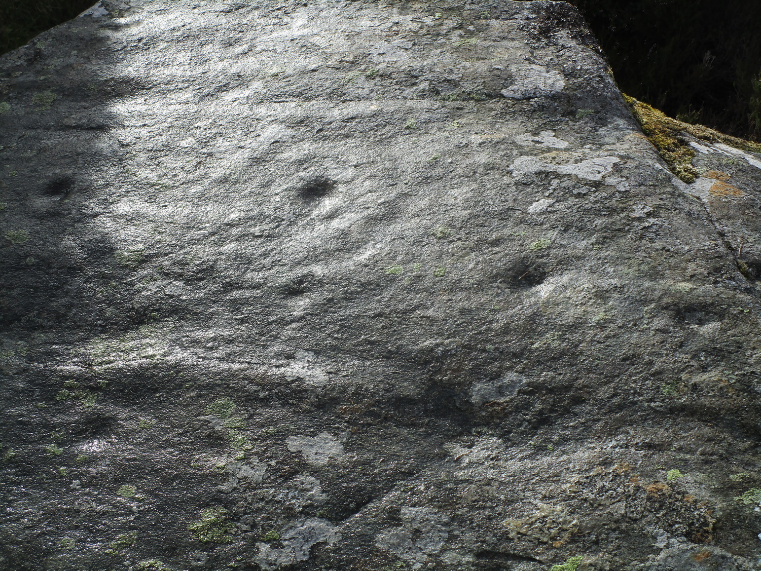
About four yards west of the Craig Hill cluster (3) carving, this gently smooth sloping rock was initially noted to have between six and seven cup-marks on it. Under the grey skies it was difficult to see any of this clearly, and so we wet the surface when Nature gave us some short bursts of light through the clouds which then enabled us to get a much better look at the design—but it’s still far from clear.
Curious eye motifCentral elements of carving
We found at least eight cups on here, two of which had single rings: the one near the top of the stone seems to be complete, whilst the other nearest the bottom of the stone looks to be incomplete. Another cup had a curious double ring; whilst the one nearest the middle of the stone has what may be three rings, with what could be a carved line running from its centre—but it’s very difficult to say with certainty until we’ve made another visit. I have little doubt that there’s more to this petroglyph than we could make out beneath the grey skies. On the west-side of the stone, the “curious” double-ring has, as its outer surround, an “eye” motif, or lozenge, which is also found on the Craig Hill cluster (3) stone a few steps away. The eye motif on both stones have the same levels of erosion and, I would suggest, were carved within a century or two of each other; perhaps even around the same time.
This one’s well worth checking out!
Acknowledgements: Huge thanks to Prof Paul Hornby for use of his photos in this site profile; and to Myrna Hurley for getting us up there. Cheers doods. 😉
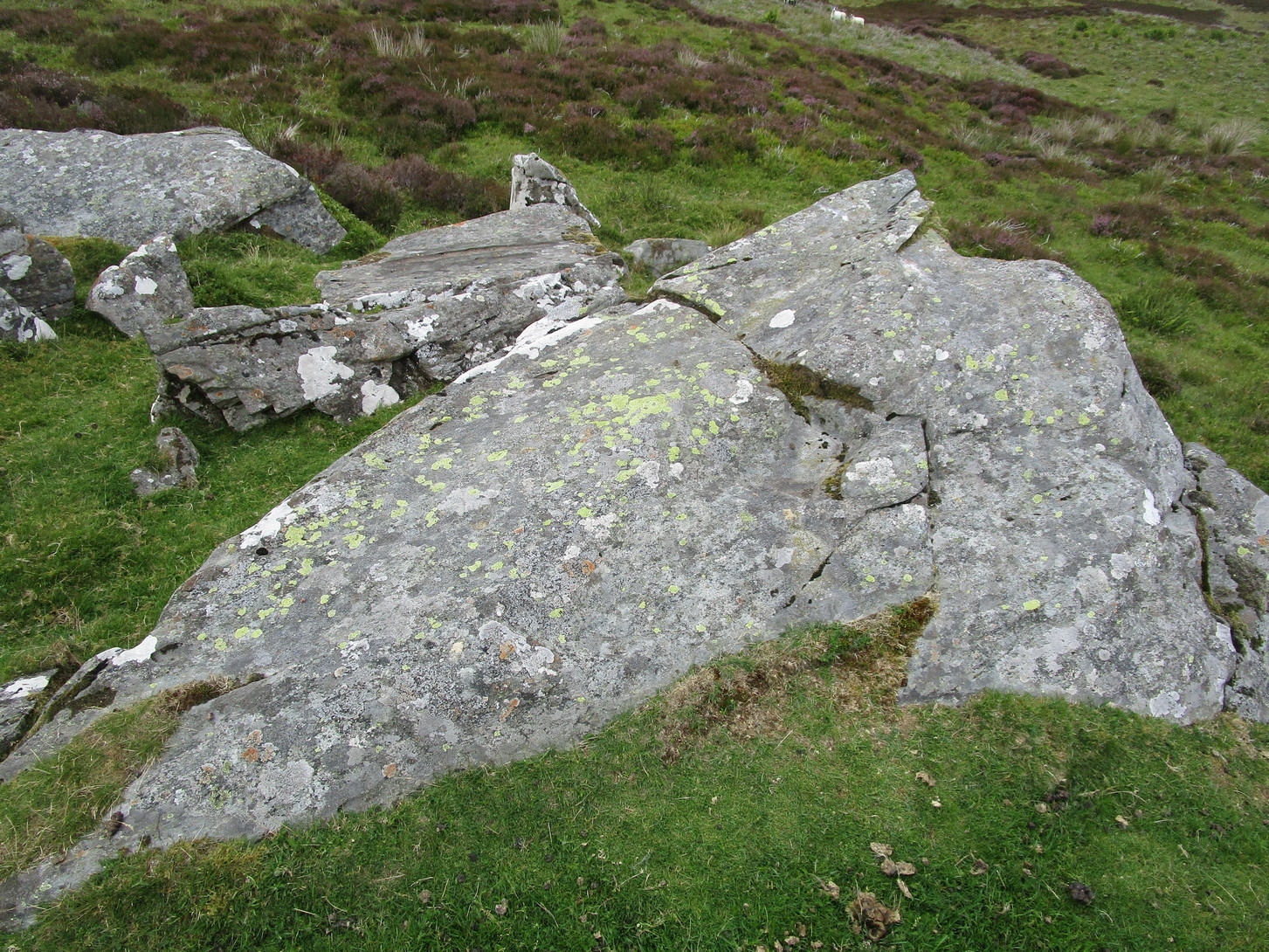
From Kenmore go east up the steep mountain road towards Glen Quaich, or if you’re coming from Amulree, go west along the same glen. After 2½ miles (4km) up the Kenmore route (nearly 9 miles on the Amulree route) you’ll reach a small lochan on your left (you’ve got a very small parking spot a coupla hundred yards before the loch). A gate and stile past the loch takes you east along a track into the moors. More than a mile on, the track splits, but you need to keep to the left and follow the track along the wallside for another 400 yards or so, where you’ll see a small crag of rocks 100 yards down the slope on your right. That’s your target!
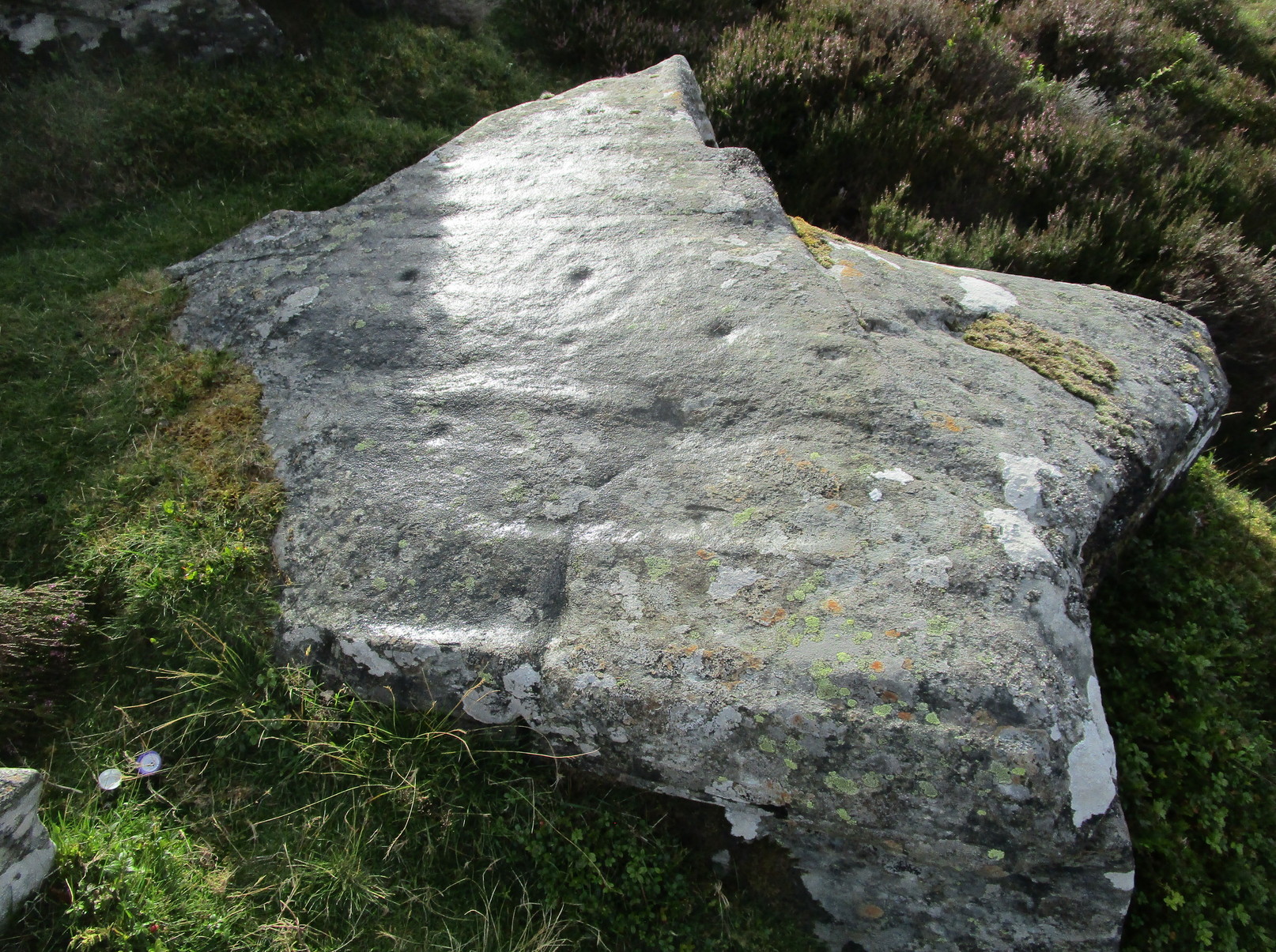
Archaeology & History
The stone in question
One of at least six rocks next to each other that possess cup-and-rings, this is the most notable of the bunch inasmuch as it’s the one that stands out above all the others. At first sight it doesn’t look impressive: a shallow scatter of nine or ten cup-marks can be seen when the light’s alright, but that’s about it. This is what George Currie (2005) noticed when he first came across it in 2004, describing it simply as “a boulder with 10 cups” a few yards away from one of it’s fellow petroglyphs (CR19, or the Craig Hill cluster-2 carving). But there’s much more to it than that. Unfortunately when we visited here, we weren’t blessed with good daylight, so were unable to get a decent appraisal of the entire design and have most probably missed some elements.
Curious double-ringed eyeGeneral overview of design
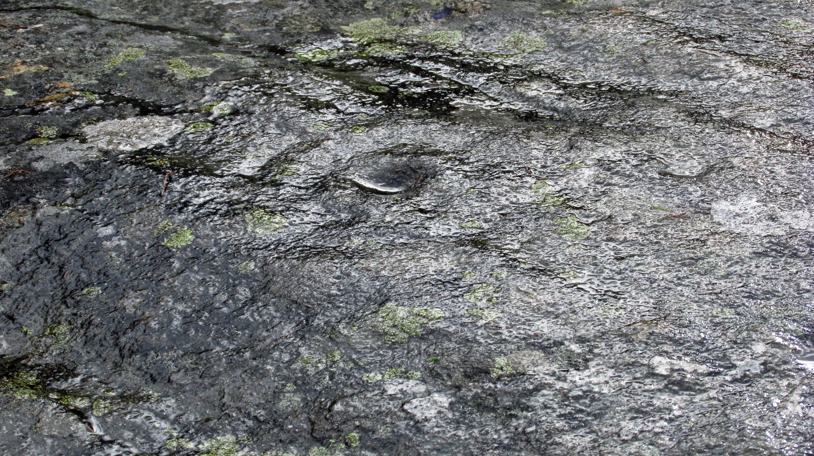
On the top sloping surface are six or seven cup-marks; another two or three are on a secondary lower level of the stone. Of those on the top, at least two of them have surrounding rings: one with a carved line coming out to the south-east; the other having a more extravagant appearance, surrounded by what looks like a secondary outer “oval”, or eye-shaped design. It’s unusual. Other lines intersect these cup-and-rings, but it was difficult to say with any certainty whether they were Nature’s handiwork, or had been modified by humans. Below these on a slightly lower level are two or three single cup-marks, one of which, close to the edge of the rock, appears to have an incomplete ring round it—but this might have just been a trick of the light. Another visit is required for a better appraisal…
Acknowledgements: Huge thanks to Prof Paul Hornby for use of his photos in this site profile; and to Myrna Hurley for getting us up there. Cheers doods. 😉