Follow the same directions as if you’re going to the excellent Morphing Stone cup-and-ring carving. From the carving, look up the field to the where the dirt-track is and, by the closest gate with a tree near it, walk straight towards it. Roughly halfway between the Morphing Stone and the gate you’ll find — eventually — the small stone in the photo with well-defined cups on it. You might need to wander back and forth until you find it, as there’s many rocks to check out here!
Archaeology & History
Possible cup-marked rock
This small cup-marked stone was rediscovered by Danny Tiernan in the late afternoon of Thursday, August 18, 2011, just as the heavens opened and the rains poured down! With at least one well-defined cup-mark and another two near the edge of the stone where the grasses had grown, this stone probably needs another look at it, as there may be more beneath the surface, much like when we first found at Morphing Stone.
Danny also found and photographed another larger boulder, a bit further up the field closer to the fence, where what may be a single cup-mark is clearly seen living on top of the rock. It’s one of those dodgy English Heritage ones though, so I’ll let those ‘qualified’ chaps check this one out and give it their expertise! It could well be another unrecorded cup-marked stone though…
Takes a bitta finding this one – especially a this time of year when the bracken’s high – but it’s worth the walk. You’re probably best finding your way to the open-air carving on the slopes above Westcliff Farm, the Guisecliff Wood 626 carving (it’s pretty easy to find). From here, walk eastwards across the top of the two fields until you hit the old gate that take you back into the woods. Now it gets difficult! Walk less than 100 yards in the same direction, if you’re lucky, along the small footpath that runs pretty level through the trees, keeping your eyes peeled for a large sloping rock above you. I’d say that it’s probably best to start checking the relevant rocks (large ones) after 50 yards in the trees, just to be on the safe side. If you aint been here before it’s probably best to check it out at the end of Winter or during Spring time. Good luck!
Archaeology & History
As noted by several people in our visit here the other day, some aspects of this carving are similar in design to the Tree of Life Stone on the eastern edge of Askwith Moor, 10 miles south of here. But the features on this large carved rock have intriguing elements of their own here: not least of which is the large square ‘box’ into which a cluster of otherwise normal cup-and-rings are enclosed. It’s a unique feature in prehistoric carvings in this part of the world — although such ‘box’ motifs can be seen further north at Dod Law in Northumberland.
The fainter cup-and-ringsBoughey & Vickerman’s 2003 drawing
There are two distinct sections of carvings on the stone, both of which have a similar tree-motif patterns, but the boxed one grabs your attention more once you’ve sat with the stone for a while. The other small cluster of cups are a little more difficult to notice, but once you see them they almost grow into life! You can just make out the surrounding rings and lines around some of these fainter cups, which I tried to capture in the photos (but without much success).
Our visit here didn’t pass without some voicing the thought that ‘box’ section could have been added at a much later date — perhaps a Victorian addition? But we could be way off the mark with that one!
There’s every likelihood of other carvings being found in and above the woodlands here, though any further exploratory excursions here can wait till winter time, as the Nature’s summer growth here is considerable and covers most of the rocks in green. The carving was first described in Boughey & Vickerman’s (2003) text as a
“Very large rock with extensive flat surface on which there seems to be two separate designs. Seven cups are joined in a branch-like pattern, the whole within a square groove from which the ‘stem’ of the branch just protrudes; away from this is an approximately linear feature with three cups enclosed by linked rings at one end and then six more cups with a partial ring.”
If you’re a rock art enthusiast, or a real healthy heathen, this site is well worth checking out!
References:
Boughey, Keith & Vickerman, E.A., Prehistoric Rock Art of the West Riding, WYAS 2003.
Take the same directions as if you’re visiting the Eastwoods Cross base and cup-marked stone, but at Eastwoods Farm itself, walk downhill following the field-wall, past the large house, then through the first gate you come to. (it’s got a ‘private’ sign on it and has some handy bulls in the field – but ask at the house and the folks there are friendly) Following the footpath along the top of the field, cross the small stream, then head across the next field to the gap in the wall. You’re here!
Archaeology & History
Boughey & Vickerman’s sketch
One of a cluster of cup-and-ring stones around the Bryan’s Wood and Eastwoods area, this carving is well worth a visit, but can be covered in shit and muck as the bulls pass through the gap here on their daily amble. If the daylight isn’t good here, it can be difficult to see the carving – and when we visited the place the other day, the cloud was low and the heavens were ready to open, so our luck was out for a change! There are a number of cup-and-rings plus a double-ring, fading their ways around the more defined cup-markings. The stone appears to have been found in the 1990s, but records of it are scant. Boughey & Vickerman (2003) fail to tell the origin of the name, nor when or who rediscovered the site. Their description of the carving tells simply:
“Large flat smooth rock sloping slightly to E. Thirteen possible cups, one with partial double ring and four with partial single-rings; three ringed cups have grooves leading from them.”
Several other excellent cup-and-ring carvings can be found around here. The hugely impressive Morphing Stone and a prehistoric lightning-carving can be found three fields away to the south, past the trees on the other side of the stream.
Folklore
Close-up of the stone
The title of ‘fertility stone’ seems a modern one, although word has it that it relates to Beltane fertility rites. However, I can find no documentary information relating to this, and the people at Eastwoods Farm and adjacent house know nothing to account for it.
References:
Boughey, Keith & Vickerman, E.A., Prehistoric Rock Art of the West Riding, WYAS 2003.
From Pateley Bridge take the B6265 road towards Grassington, turning left just a coupla hundred yards over the river bridge, towards Bewerley. Go through the hamlet and take the second on the right, up the steep zigzagging lane. A half-mile up the hill, watch out for the track onto Westcliff Farm. Go along here and onto the footpath, then as you walk through the field, look uphill where the long wall runs into the trees, and you’ll see a rock in the walling near the top. That’s it!
Archaeology & History
Just over the edge of the northern section of The Intakes at the western end of Guisecliff Wood, on a large rock in the walling near the very top of the field above Westcliff Farm, we find this little-known but very impressive cup-and-ring stone.
Close-up of some cupsBoughey & Vickerman’s sketch
Upon first sight the rock was aptly described by Danny Tierney as being like a Viking Hogback Stone with cup-markings along the sloping side of the long rock as it grew into the drystone walling. He had a point! It’s a curious carving (how many times do I say that!?), with the majority of the cup-marks and lines etched into the south-sloping face of the rock. Other cups found further down the stone stretch along the eastern side towards ground level; and we have a small line of cups etched onto the normal horizontal face halfway along the stone.
The carving was rediscovered by Stuart Feather in the ‘Sixties and was all-but-forgotten until Boughey & Vickerman (2003) rejuvenated it in their catalogue. They told it to be:
“Large rock of coarse grit lying with long uneven surface E to W, at ground level to S and E, but with high N and W faces. Up to eighty cups but some may be due to pebbles or other natural causes; one cup has two half-rings which, like some grooves visible, suggest a now incomplete design.”
The fascinating ‘boxed’ cup-and-ring stone of Guisecliff Woods 629 can be found less than 200 yards east of here, in the trees, and is certainly worth seeking out!
References:
Boughey, Keith & Vickerman, E.A., Prehistoric Rock Art of the West Riding, WYAS 2003.
Feather, Stuart & Hartley, C.E., “The Yorkshire Archaeological Register, 1964: Bewerley. W.R.”, in Yorkshire Archaeological Journal, volume 41, 1965.
From the bottom of Pateley Bridge, just out of town take the left turn to Bewerley and go through the village; or from Glasshouses follow the road over the River Nidd and round. Both ways take you to meet the steep and winding Nought Bank Road, which you should follow all the way to the top of the moorland hill. You can just park up by the footpath taking you east. Then cross the road and walk west on the dirt-track to Rowan Tree Crags. 100 yards along, the gentle sloping moor on your left is the Old Wife’s Ridge.
Archaeology & History
The academic history of this moorland is poor, save occasional notes about lead mining and quarrying (Jennings 1967). Speight (1894) describes the finding of large pieces of lead-worked Roman inscriptions nearby that were found in January 1735 — one of which had the letters ‘BRIG’ cut into it, thought to be a referral to the land or deity, Brigantia. Examples of prehistoric rock art occur at nearby Guisecliff Woods, due east, but there are no specific notices about the archaeology of this hillside.
Long overgrown stone at Old Wife Ridge
When we visited the place yesterday, much of the heather had been burned (the previous year) and we found two stones which looked suspiciously as if they had stood upright in the past, and may have had played some part in the naming and myth of the Old Wife on this part of the moors. I can find no other records of any remains here.
Folklore
References to the Old Wife scatter our northern lands and invariably refer to an aspect of the heathen Earth Mother of our peasant ancestors, particularly in Her aspects of winter and early spring. In Scotland and Ireland She was commonly known as the cailleach. Sadly I can find no extant lore relating to Her mythic aspects in the landscape on these hills. A field-name to the south, Nanny Black Hill, may have related to the Old Wife.
References:
Jennings, Bernard (ed.), A History of Nidderdale, Advertiser Press: Huddersfield 1967.
o’ Crualaoich, Gearoid, The Book of the Cailleach, Cork University Press 2003.
Speight, Harry, Nidderdale, Elliot Stock: London 1894.
From the lovely village of Summerbridge (near Pateley Bridge), go up the steep Hartwith Bank road, going straight across at the crossroads for another few hundred yards, passing the old tombs of Graffa Plain on your right…and they’ll start appearing on your left-hand side (west). Do not go into the expensive National Trust car-park. Instead (if you’ve already gone too far), about 100 yards before the Car Park you’ll find a small dirt-track on your left a short distance away. But if you drive past the rip-off car park, another 100 yards on there’s another spot where you can easily park up on the right-hand side of the road. Then cross the road and follow y’ nose…
Archaeology & History
The OS grid reference given above is an approximation — for obvious reasons. This is a huge area that’s covered by Britain’s finest natural megalithic features, obviously sculptured by Nature Herself — though many are the historians who sought to give Druids the credit here. God knows how! The area over which these magnificent rock sentinels live covers some 60 acres and is some 1000 feet above sea level. The view from the hill around which the encircling parade of rocks guards is excellent, allowing our eyes to catch focus on the distant lands of Whernside, Simon’s Seat, York Minster, the Cleveland Hills and Kilburn’s white horse. It’s quite a view.
Easternmost Rocking StoneIdol Stone (Godfrey Higgins 1826)
But this tends to be overlooked when you first visit the place, as the rocks which surround and walk alongside you overwhelm with impressions not encountered before. To those with spirit, you’ll be bouncing and running all day here, clambering upon rocking stones, jumping between dodgy gorges that await falls, and just aching to climb pinnacles that deny you. But then, if you need the selfishness of silence, this arena will only grant such solace when the rains are about, or dense fog and low cloud keeps others from this haunting amphitheatre. And it’s not surprising… The mass of rocks contort into the most beautiful and curious simulacra, which would not have gone unnoticed, nor deemed unimportant in the sacred landscape of our ancestors…
Brimham Rocks have been written about since the 17th century, though they didn’t receive the serious attention of outsiders until the 19th, when numerous Victorian writers — from antiquarians and geologists, to archaeologists and Druids — got to hear about the place. And by the beginning of the 20th century, a veritable mass of articles had been written in journals and travelogues of all persuasions! These quiet Yorkshire Rocks had become truly famous!
Brimham Rocks (Walbran 1856)Old Woman and her consort
A lengthy essay was written in the distinguished archaeology journal of its time, Archaeologia, by northern historian Hayman Rooke (1787), who thought that some of the rocks here had been tampered with by the druids; with the legendary Cannon Rock in particular possessing oracular properties. The site as a whole was, he posited, a temple for Druids in ancient days. Certainly the place would have been deemed as sacred, whether by the druids or our more remote neolithic and Bronze Age ancestors.
Harry Speight & his mates, c.1890
In Harry Speight’s magnum opus, Nidderdale (1894), he described these rocky giants as best as he could, admitting as others before and since, that no mere words can convey the impression that only a personal encounter liberates, saying:
“The Brimham Rocks are among the greatest natural wonders of Yorkshire, and many have been the theories from time to time advanced as to the cause of their extraordinary aspects… The resemblances to natural and artificial objects are most striking. There we have the Elephant Rock, the Porpoise Head, the Dancing Bear (a very singular, naturally-shaped specimen), the Boat Rock, showing the bow and stern completely, etc. Then there is the great Idol Rock, a most mysterious-looking object, of almost incredible size and form. It is a perfectly detached block, fully twenty feet high, weathered along face joints into three roughly circular pieces, each from 40 to 50 feet in circumference, piled one above the other; the whole mass, weighing by estimation over 200 tons, being poised on a pyramid 3½ feet in diameter; the pivot itself supporting this immense column having a diameter of barely 12 inches.
“East of the guide’s house are the famous Rocking Stones, consisting of a group of four rocks, which were discovered to be movable in the year 1786. The two on the west side weighing approximately 50 and 25 tons, require but little force to vibrate, while those on the east side, though much smaller are not so well poised and do not move readily. Each of the larger stones has a basin-like cavity on the top, and a kind of knee-hole open to the north, said to be the work of Druids. Close to the Rocking Stones are the appropriately-named Oyster-shell Rock, and the Hippopotamus’ Head. Turning now some thirty yards north of the Idol Rock we ascend Mount Delectable, where is the agreeable Courting or Kissing Chair, happily at not too close quarters with the above Hippopotamus’ Head and Boar’s Snout. The Chair consists of a single seat, but why it should be so called, I had better leave the amorous lover to solve. West of these is the more sober Druid’s Reading Desk, with its church-like lectern on a stout stone base. The we come to the Lover’s Leap, a gigantic and abrupt face of beetling crag, weathered to the west, and rising to a height of 60 to 70 feet, with three immense fragments balanced in a very remarkable manner at the summit. The rock is in tow principal sections, and an iron hand-rail has been fixed across the chasm to enable visitors to look down from the top. Further south are the Frog and Tortoise Rocks, the latter presenting from one point of view a capital resemblance to a tortoise creeping up the face of the crag towards the imaged frog. A little below this is a good imitation of a cannon, projecting from the edge of the cliff. In addition to these singular resemblances there are many others which the guide points out, such as the Yoke of Oxen, Mushroom Rocks, Druid’s Oven, Dog’s Head, Telescope, and the curiously perforated Cannon Rock, etc.”
In a later work, Speight (1906) also mentioned the existence of a Druid’s Circle some 300 yards west of the main natural temples, but this site appears to have been destroyed. Thankfully the large standing stone on Hartwith Moor, a mile to the south, can still be found upright…
Folklore
Idol Stone (Hargrove 1809)
In folklore, there’s little surprise this place was held by just about every 18th and 19th century historian as a ‘druidic site.’ But more interesting – in the light of Paul Devereux’s (2001) work on acoustic archaeology – is what Edmund Bogg (c.1895) said of these huge contorted stones:
“In bygone days these immense stones were supposed to be the habitation of spirits. The echo given from the rocks was said to be the voice of the spirit who dwelt there, and which the people named the Son of the Rocks. From a conversation we had with the peasantry not far from here, it seems the ancient superstition had not yet fully disappeared.”
This is precisely the notion of spirit given to rocky places elsewhere in the world, where the very echo was perceived as the ‘voice of the rocks’. Meditate on it a bit, in situ. (a fine summary of this notion and its implications — which has crept into archaeology of late — can be found in Paul Devereux’s work, Stone Age Soundtracks)
One of Brimham’s southwestern rocks was known as the Noon Stone when Mr Rooke (1787) came here. There are many stones with this name scattering Yorkshire and other northern counties, each with the same mythic background: that the sun casts a shadow from it at midday to indicate the time of day. Of this Noon Stone Mr Hooke also told us that,
“On Midsummer Eve fires are lighted on the side. Its situation is apposite for this purpose, being on the edge of a hill, commanding an extensive view. This custom is of the most remote antiquity.”
On the very southern edge of Brimham’s Rocks (some might say beyond their real border) is the Beacon Rock — and it is aptly named: as in the year 1887 on the day of Queen Victoria’s Jubilee, a great beacon fire was lit here, signalling to others in the distance. Its title however, pre-dates Victoria’s Jubilee, though we don’t know how far back in time it goes…
…to be continued…
References:
Bogg, Edmund, From Eden Vale to the Plains of York, James Miles: Leeds c.1895.
Devereux, Paul, Stone Age Soundtracks: The Acoustic Archaeology of Ancient Sites, Vega: London 2001.
Grainge, William, The History and Topography of Harrogate and the Forest of Knaresborough, John Russell Smith: London 1871.
Harrison, William, A Descriptive Account of Brimham Rocks in the West Riding of Yorkshire, A. Johnson: Ripon 1846.
Michell, John, The Earth Spirit: Its Ways, Shrines and Mysteries, Thames & Hudson: London 1975.
Michell, John, Simulacra, Thames & Hudson: London 1979.
Rooke, Hayman, “Some Account of the Brimham Rocks in Yorkshire,” in Archaeologia journal, volume 8, 1787.
Speight, Harry, Nidderdale and the Garden of the Nidd, Elliot Stock: London 1894.
Speight, Harry, Upper Nidderdale, with the Forest of Knaresborough, Elliot Stock: London 1906.
Walbran, John Richard, A Guide to Ripon, Fountains Abbey, Harrogate, Bolton Abbey, etc, Johnson: Ripon 1856.
Various ways to get here. I s’ppose the easiest is from Dacre village. If you go just past Sunny House, take the footpath on your right & walk along it, roughly straight across a number of fields, until you hit the footpath known as the Nidderdale Way. The field you’re now in should be scattered with numerous rocks all over the place (if it aint, you’re in the wrong place), reaching down towards the trees. Walk straight towards the trees for another 100 yards and the carving is somewhere hereabouts under your nose! You’re very close! If, however, you decide to walk up the Nidderdale Way from Dacre Banks, the field you need is the one immediately to your right just before you reach the Monk Ing Road trackway. The Tadpole Stone (or Eastwoods Rough II carving) is in the same field, close to the Nidderdale Way path — check that out aswell!
Archaeology & History
This is a large carving I found in April, 2006, in the company of rock-art student Richard Stroud (who sent us the pictures). Twas in the midst of a fine day wandering about checking some of the ‘known’ sites in the area, when we happened across two or three previously unknown sites — and as the day wore on, just before we were gonna head for home, this little beauty poked the edge of its head out of the turf! It had the pair of us in near rapture, with numerous “Wow’s” and excitable expletives coming from our mouths! We’re easily pleased us rock-art doods — but then it is a beauty when you first see it.
We came here several times in the weeks following its initial discovery, and it seemed that on each visit, we found an additional aspect to the carving. It seemed to keep changing each time we came here — hence the name ‘Morphing Stone’!
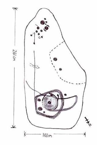
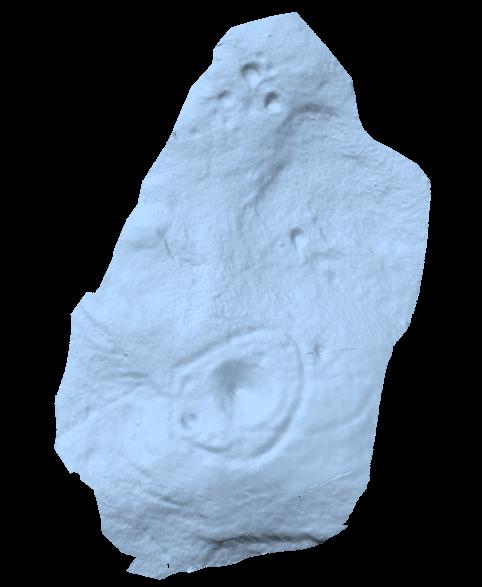
The prime feature in the carving is the very large oval-shaped ‘ring’ with huge carved bowl in the middle and several outlying cups-markings around it. Although it’s not plain to see in the photos, there’s a large tongue-shaped protuberance jutting out from one side of the main ringed feature. You can also see a small cluster of cup-marks on the top-right of the rock: from here — though it isn’t easy to see in the photo — a long straight line links up with the edge of the major central ring. Other lines run off on the top of the main feature and there are several other cup-markings on different parts of the stone. It’s obviously best to see the carving “in the flesh”, so to speak, to get a good impression of what it actually looks like. And, to those of you who might wanna venture up here, there are several others nearby.
A year or two after rediscovering the carving, rock art student Keith Boughey (2007) described the stone, saying:
“Measuring 2.61m from N-S and 1.88m from W-E at its greatest extent, the carved surface carries quite a complex design… At its N end is a large cup/basin with an approximate diameter of 25-30cm, surrounded by a ring that may or may not be complete: 2 cups have been incorporated into the ring on its N and W side. W of this ring a groove leads off S to a further possible cup. On the E side of the large central cup are 3 further cups of varying size. These motifs are all enclosed within a wide groove, which forms almost a dome pattern. Out of the ring, a further groove runs NW out of the design, bisecting the enclosing groove, curving round to form a handle shape before running back in towards the large central cup. The groove shows signs of continuing E towards the edge of the stone. Just outside the W edge of the enclosing dome is one well-defined cup. S of this, in a slight depression, are 2 further cups of differing size. A straight groove appears to run SW out of the enclosing dome shape on its E side towards further motifs on the stone’s S side. The groove may run into an area of cup marks, but there appears to be a break before it continues. When exposed, the carvings looked quite fresh and sharp, suggesting that they had remained covered for some considerable time – possible since antiquity or at least from a time in the prehistoric past when cup-and-ring-markings had begun to lose their significance and were no longer required to be visible in the landscape.”
To those of you who like the new computer images of cup-and-rings, the three below are samples from a number of such images done after the stone had been discovered. Intriguingly, the long line running between the cluster of cups to the large cup-and-ring doesn’t show up too well; but the barely perceptible line running out, zigzag-fashion, from the large central cup-and-ring, shows up much clearer than when looking with the naked eye.


")


")