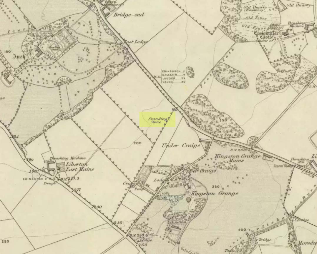
Take the A7 road south from Edinburgh central (off Princes Street) for several miles. It becomes known as the Old Dalkeith Road eventually, just as it passes the huge wooded ground of Craigmillar Castle on your left (east) and the Inch estate on your right. Walk along here, keeping your eyes peeled for the small path that takes you onto Ravenswood Avenue. Barely 30-40 yards from the main A7 road, the standing stone is there surrounded by railings.
Archaeology & History
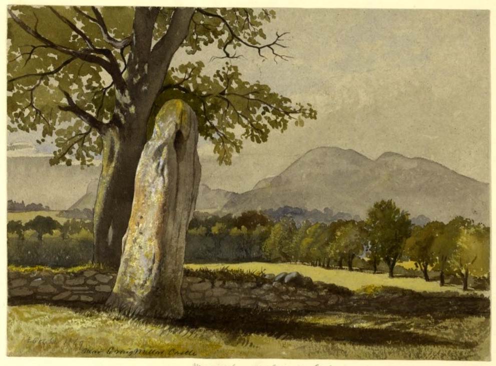
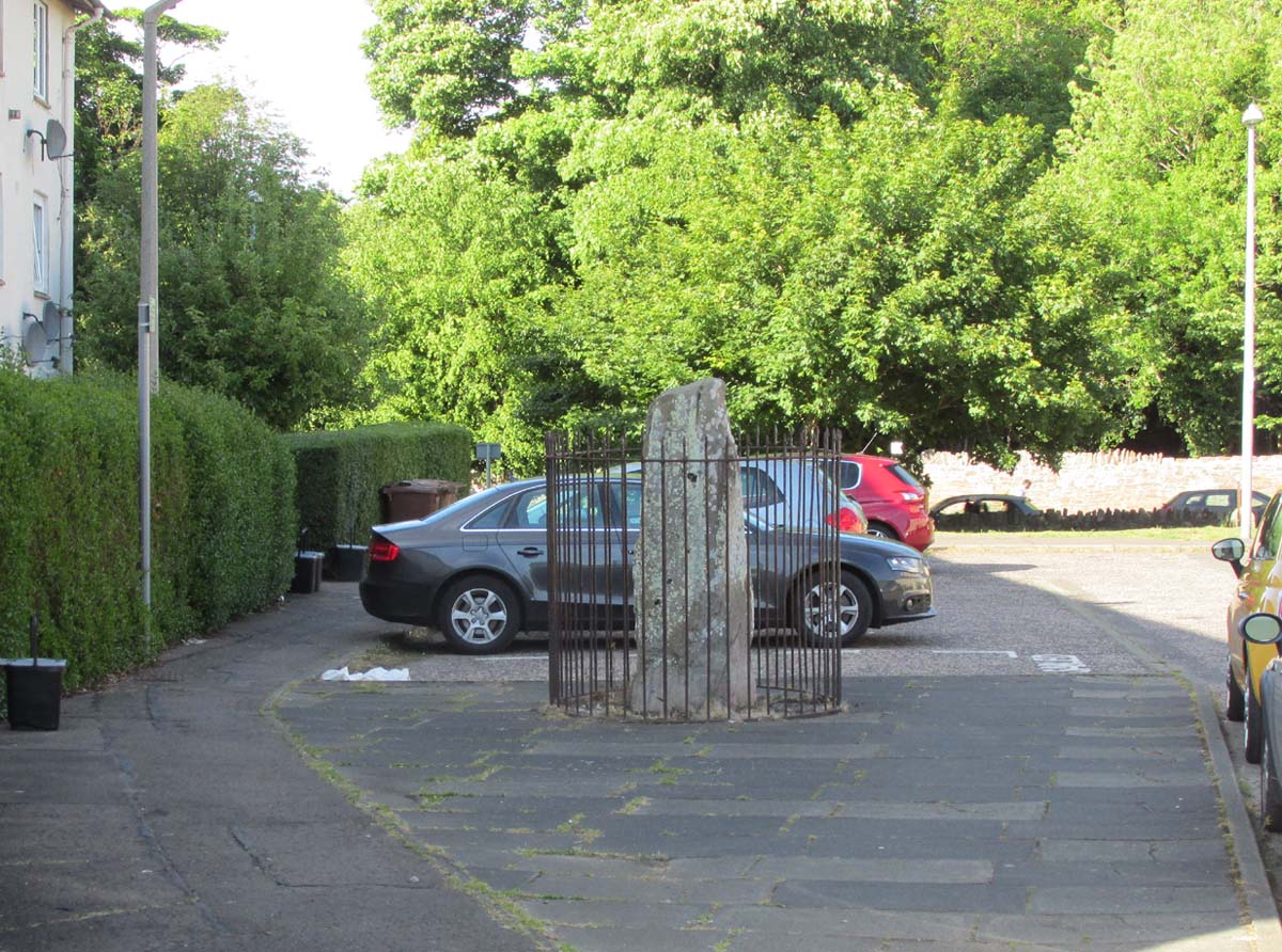
A curious place to find a standing stone – especially one that’s still alive! But that’s what we find on the Inch housing estate, thankfully. Highlighted on the 1855 Ordnance Survey map, it was one of a number of standing stones described in George Good’s (1893) fine survey on Liberton parish, which he thought commemorated ancient battles. When he wrote about it, the monolith was “built into the wall on the public road to Greenend”, just as shown on the OS-map. He told how the
“stone was taken down in the beginning of the present century (c.1801), when the road was widened, and it long lay in the field opposite, but was restored to its original place in 1891.”
When the Royal Commission (1929) lads came here many years later, they gave their own archaeocentric description, telling:
Site shown on 1855 mapThe old stone in its cage
“About 40 yards from the main road near Little France…is a standing stone, which is set up without packing, with its main axis almost due north and south, but with a slight inclination towards the east. It stands 6¾ feet above ground, and has a girth of 6 feet 5 inches at 3 feet from the base. It is of grey sandstone, badly weathered on two sides and without traces of any artificial markings or design.”
The monolith was included in Adam McLean’s (1977) megalithic survey of the area, where he rightly said how the iron fence that surrounds the stone destroys any atmosphere that might once be had here. Still, at least it’s still standing and is worth checking out if you’re in the area.
Folklore
The Ravenswood Stone
An old footpath that runs dead straight from Craigmillar Castle towards the stone was long ago said to be the pathway taken by the ghost of a white lady.
In days prior to the housing estate being built, local folk had annual bonfires here between Samhain (Halloween) and Guy Fawkes Night (Oct 31 – Nov 5).
References:
Good, George, Liberton in Ancient and Modern Times, Andrew Elliot: Edinburgh 1893.
McLean, Adam, The Standing Stones of the Lothians, Megalithic Research Publications: Edinburgh 1977.
Royal Commission on the Ancient & Historical Monuments of Scotland, Inventory of Monuments and Constructions in the Counties of Midlothianand West Lothian, HMSO: Edinburgh 1929.
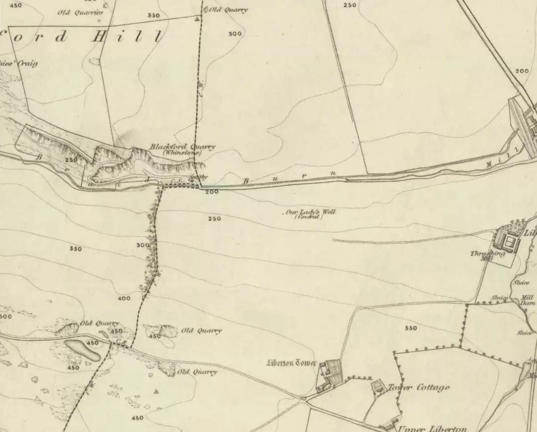
Holy Well (destroyed): OS Grid Reference – NT 2728 6669
Archaeology & History
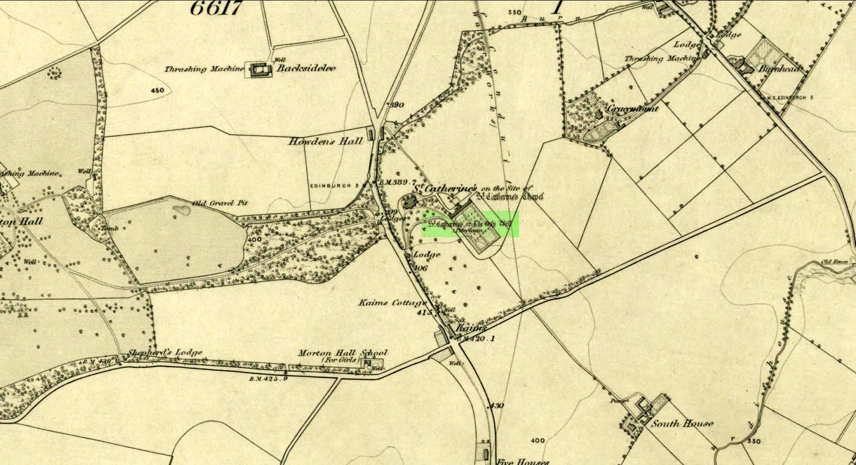
Our Ladys ‘Well’ on 1855 map
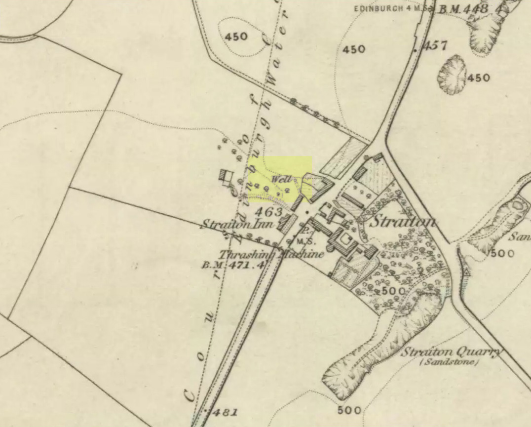
This is another all-but-forgotten holy well once dedicated to the Virgin Mary, close to the south-side of Edinburgh’s outer ring-road. It would seem to have been one in a cluster of sacred wells not far from each other (with the two Jacob’s Wells and St. Margaret’s Well at nearby Pentland), whose traditional stories have fallen prey to the incredulity of ‘progress’. I can find very little about the site, other than the note given it in George Good’s (1893) Liberton survey where, in stepping south towards the old hamlets of Broomhill and Straiton, he told:
“A little to the west of the hamlet, and near what was called Straiton Green, is an old draw-well dedicated to the Virgin, and known by the name of Our Lady’s Well. There may possibly have been a cell or chapel near this well, but no tradition or history regarding it is extant.”
We can only presume that the ‘Well’ which is highlighted on the first OS-map in 1855, maybe 20-30 yards west of the old road on what looks like a small park or ‘Green’, would be the ‘Lady Well’ in question. (another ‘Well’ is shown at Broomhill Cottage, which is unlikely to be the contender)
In Thomas Whyte’s (1792) lengthy survey of Liberton village, as it was in the 1790s, we come across what seems to be the earliest description of this long-lost sacrede site on the northwest side of the parish. In writing of the beauty of the countryside hereby in those times, he told how,
“on the north by the rivulet called Braid’s-burn, near which there is a well which has the appellation…of the Lady’s or Virgin Mary’s well, famous for its large current, and the salubrity and lightness of its waters.”
Site of Our Lady’s Well
Our Ladys Well on 1855 map
Mr Whyte believed that its dedication to Our Lady went way back, probably before Liberton parish was given to St. Cuthbert in the 11th or 12th century (whose own holy well could once be found several miles north, near Leith). Generally, wells that are dedicated to ‘Our Lady’, refer to the Virgin Mary; but prior to any christian affectation, the animistic genius loci of the waters would have been a local spirit.
It was visited and described by the Ordnance Survey lads in the Name Book of 1851, in which they said that Our Lady’s Well was,
“The site of a celebrated well situated in a hollow on the farm of Liberton Tower Mains, and dedicated to St. Mary, as it and the field is well known to be called to this day, “The lady’s Field” & Well”. This well however about 50 years ago underwent a drainage during some improvements that were making on the land. In its covered condition it takes a S.E. course till its Confluence with the Braid Burn where it is shown to this day as the water coming from the Lady’s Well, and from which a body of crystalized water flows copiously. It was supposed that a chapel was somewhere Convenient which gave rise to the name, but all traces have long since disappeared….”
“There is no tradition recorded among the County people as to whether this was a holy well, or resorted to for superstitious purposes. But it is well ascertained to have been once a remarkable well & an object well known and though now covered-in, the place is still well known, as is also the name.”
Although this holy well was shown on early and late 19th century OS-maps as ‘covered’, trying to find its exact position today has proven difficult. When Paul Hornby and I visited the site after some heavy rains in June, 2017, we found a large pool of water in the field exactly as shown on the old map. This was, however, misleading, as the owner of the land and the Blackford Glen Western Riding school—a Mr John Fyfe—told us that they had, for years, always wondered about its exact position, but been unable to ascertain it with any certainty. The pool in the field always appeared after the rains, he said. He did tell us however, that many years ago when he was digging in order that the Braid Burn stopped flooding his property, he came upon a length of ancient piping running in the direction of the burn, some 5 or 6 feet down, whose use he could not ascertain—but which might have once conducted the waters from the Lady Well away. No water was running through it though.
Near the middle of Liberton village a century or so ago, another holy well of the same name could once be seen less than a mile to the east.
Tumulus (destroyed): OS Grid Reference – NT 3076 7177
Archaeology & History
Long since gone, this little-known burial mound could once be seen not far from the old mansion of Niddrie House. The only reference I’ve found of it is in Thomas Whyte’s (1792) early essay on the parish of Liberton, where he told:
“East from the house and plantations, and on the north side of the public road, is a rising ground, or tumulus, called the Law Know, where, in more early times, judgment was dispensed, and where, probably, certain acknowledgments were made, by those who held of the baron or family. It is of a circular form. And this is the cafe with all places of the same kind. For they were considered as emblems of the sun, that great object of Druidical worship.”
The site appears to have been destroyed when the Industrialists blasted their quarry here and, as historians well know, quarrymen are dreadful when it comes to making notes of anything! Any additional info on this place would be good….
This is the first detailed guide ever written on the holy wells and healing springs in and around the ancient city of Edinburgh, Scotland. Written in a simple A-Z gazetteer style, nearly 70 individual sites are described, each with their grid-reference location, history, folklore and medicinal properties where known. Although a number them have long since fallen prey to the expanse of Industrialism, many sites can still be visited by the modern historian, pilgrim, christian, pagan or tourist.
The book opens with two introductory chapters: the first explores the origin and nature of holy wells and what they meant to local people in earlier centuries; and the next is a comparative overview of water cults worldwide. It is an invaluable guide for any student or tourist who wants to look beneath the modern history of the city and get a taste of the more archaic customs that once belonged here…
Take the A701 road from the east end of Princes Street south—down North Bridge, South Bridge, Nicolson Street, onto Liberton Road and then Liberton Gardens—towards Penicuik. 3¾ miles along, in the parish of Liberton itself, where the A701 is called Howden Hall Road, keep your eyes peeled for the turning into the Toby Carvery on your left. Park up and walk across the grass and look behind the trees ahead of you (if you can’t find it, ask the people in the pub). .
Archaeology & History
Located south of Liberton village—a few hundred yards west of the long-gone chapel erected by St. Margaret in honour of St. Catherine—this famous holy well is now in the grounds of a public house and is easily accessed. It has been described by many historians through the centuries, from Matthew Mackaile’s (1664) short work to more recent tourist guides. When the local historian George Good (1893) told about it, local lore still spoke of the old church. “These lands,” he wrote,
“belonged to a very ancient chapel dedicated to St. Catherine, which stood with its burying-ground near the modern mansion of St. Catherine’s. All trace of this chapel has disappeared, but at the end of last century its ruins were still extant. It was reputed to be the most ancient place of worship in the parish, and the ground around the chapel was consecrated for burials. Hither came annually in solemn procession the nuns from the Convent of Sciennes, a foundation due to the piety of one of the St. Clairs of Rosslyn, who may possibly have also been connected with the origin of the Chapel of St. Catherine.”
Its relationship with the world-famous Roslyn Chapel, less than 4 miles to the south, remains (to my knowledge) unproven, but it’s an association that would not be unlikely. This aside, St Catherine’s Well has a long history. Described in Hector Boece’s Latin text Scotorum Historia (1526), we have one John Bellenden to thanks for a wonderful translation into early english under the title of The History and Chronicles of Scotland in 1536. Herein one of the later editions we read, in that quaint old dyslexia:
“Nocht two miles fra Edinburgh is ane fontane dedicat to Sanct Katrine, quhair sternis of oulie springs ithandlie with sic abundance that howbeit the samin be gaderit away, it springis incontinent with gret abundance. This fontane rais throw ane drop of Sanct Katrine’s oulie, quhilk was brocht out of Monte Sinai, fra her sepulture, to Sanct Margaret, the blissit Quene of Scotland. Als sone as Sanct Margaret saw the oulie spring ithandlie, by divine miracle, in the said place, sche gart big ane chapell thair in the hounour of Sanct Katrine. This oulie has anr singulare virteu agains all maner of kankir and skawis.”
In the middle of the 17th century, its medicinal virtues were brought to the attention of the surgeon Matthew Mackaile who, in 1664, wrote:
“In the paroch of Libberton, the church whereof lyeth two miles southward from Edinburgh, there is a well at the Chapel of St. Catherine’s, which is distant from the church about a quarter of a mile, and is situate toward the south-west, whose profundity equaleth the length of a pike, and is always replete with water, and at the bottom of it there remaineth a great quantity of black oyl in some veins of the earth. His Majesty King James VI, the first monarch of Great Britain, of blessed memory, had such a great estimation of this rare well, that when he returned from England to visit his ancient kingdom of Scotland in anno 1617, he went in person to see it, and ordered that it should be built with stones from the bottom to the top, and that a door and a pair of stairs should be made for it, that men might have the more easy access into its bottom for getting of the oyl. This royal command being obeyed, the well was adorned and preserved until the year 1650, when that execrable regicide and usurper, Oliver Cromwell, with his rebellious and sacrilegious complices, did invade this kingdom, and not only defaced such rare and ancient monuments of Nature’s handiwork, but also the synagogues of the God of nature.”
St Catherine’s Well today
This historical appraisal has been echoed by other writers and is very probably accurate. Some years after Cromwell and his murderers had desecrated the land and people in this area, the well was again repaired to its former condition and slowly, quietly, people began traditionally using the site for ritual and healing once more. But over the next two hundred years, probably through religious persecution by the Church, the site was used less and less and, by the time Thomas Muir (1861) visited and wrote about it, the well-house had become “dilapidated”. A few years later when the holy wells writer J.R. Walker (1883) visited the place, he found that not only was it still,
“celebrated for the cure of cutaneous diseases, (but) it is still visited for its medicinal virtues”; and was “now carefully protected and looked after.”
In James Begg’s (1845) account of the well for the Statistical Account, he told:
“At St. Catherine’s is a well which contains a quantity of mineral oil or petroleum, obtained most probably from the spring flowing over some portion of the coal beds. This bitumous matter floats copiously on the surface of the water, and is also partially dissolved in it. The spring is reckoned medicinal by the country people, and may have some slight efficacy in cutaneous eruptions…
“At St Catherine’s, there is the famous well, before alluded to, anciently called the Balm Well. Black oily substances constantly float on the surface of the water. However many you remove they still appear to reside in this well, and it was much frequented by persons afflicted with cutaneous complaints. The nuns of the Sheens made an annual procession to it in honour of St Catharine. King James VI visited it in 1617, and ordered it to be properly enclosed and provided with a door and staircase, but it was destroyed and filled up by the soldiers of Cromwell in 1650. It has again been opened and repaired, and is now in a good state of preservation.”
The “nuns of the Sheens” who made the annual pilgrimage here were the nuns of St. Catherine’s of Sienna, in Italy! This crazy-sound journey is more than one thousand miles long and its nature and origin needs exploring in greater depth—although a “Nunnery of St. Catherine of Siena at Edinburgh” was founded in 1516 at Sciennes in Edinburgh, less than three miles away. Much easier! 🙂
It would have been more than just the healing properties of the oily waters that called the nuns across their incredible journey, but they would, no doubt, have been of considerable mythic importance. All of the early writers comment about it and seem confident in its abilities. As the Liberton historian George Good (1893) said,
“…there can be little doubt that its waters had a healing tendency. Oils when rubbed on the skin have often been found to produce most beneficial results in skin diseases. The tarry substance or petroleum mixture discovered in this spot was no doubt due to the presence of the coal or shale strata of the district. The existence of the oil-works at Straiton and elsewhere cannot fail to throw a light upon the history and peculiarities of the so-called Balm Well of St. Catherine’s, which even yet has an occasional visitor.”
This oily substance was examined for medical potential by Dr. George Wilson in the mid-19th century, who found:
“The water from St Katherine’s Well contains after filtration, in each imperial gallon, grs. 28.11 of solid matter, of which grs. 8.45 consist of soluble sulphates and chlorides of the earths and alkalies, and grs. 19.66 of insoluble calcareaous carbonates.”
I am not aware of any modern accounts of cures attached to St Catherine’s waters, but have little doubt that some people will have found it useful….
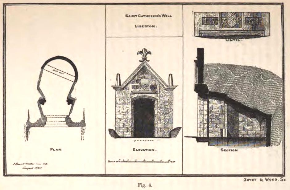
The architecture of the small well-house covering the waters would seem insubstantial, but the Royal Commission (1929) account told:
“The well is housed within a tiny vaulted structure. The Renaissance front is relatively modern, but it contains a door lintel, probably quite unconnected with the structure, on which is inscribed the date 1563 within recessed panels flanking a central panel, which contains a shield flanked by the initials A.P. The shield bears a saltire, in the sinister quarter of which is a Latin cross placed horizontally, i.e., with the shaft towards the fess point (? a merchant’s mark); the upper quarter contains a much worn object resembling a broad arrow, point uppermost.”
Plan of site in 1883
The iron-clad door is locked, as the visitor will see. Please enquire at the hotel regarding it being opened to look inside. Upon our visit here in June 2017, the waters, as in J.R. Walker’s (1883) day, were still bubbling up and were quite high, but it looked as if the inside needed cleaning. For a change, we didn’t drink the water…..
Folklore
Although various writers have posited that the oily waters are probably due related to the nearby coalfields, legend tells otherwise:
“It owes its origin, it is said, to a miracle in this manner: St. Katherine had a commission from St. Margaret, consort of Malcolm Canmore, to bring a quantity of oil from Mount Sinai. In this very place, she happened, by some accident or other, to lose a few drops of it, and, on her earnest supplication, the well appeared as just now described.” (Thomas Whyte 1792)
References:
Banks, M. MacLeod, British Calendar Customs: Scotland – volume 1, Folklore Society: London 1937.
Begg, James, “Parish of Liberton“, in New Statistical Account of Scotland – volume 1: Edinburgh, William Blackwood: Edinburgh 1845.
Muir, Thomas S., Characteristics of Old Church Architecture,in the Mainland and Western Isles of Scotland, Edmonston & Douglas: Edinburgh 1861.
Royal Commission on the Ancient & Historical Monuments of Scotland, Inventory of Monuments and Constructions in the Counties of Midlothianand West Lothian, HMSO: Edinburgh 1929.
Walker, J. Russel, “Holy Wells’ in Scotland,” in Proceedings of the Society of Antiquaries of Scotland, volume 17, 1883.
Watson, W.N.B., “The Balm-Well of St Catherine, Liberton,” in Book of the Old Edinburgh Club, volume 33, 1972.
Whyte, Thomas, “An Account of the Parish of Liberton in Midlothian, or County of Edinburgh,” in Archaeologica Scotica, volume 1, 1792.
Wilson, Daniel, Memorials of Edinburgh in the Olden Times – 2 volumes, Edinburgh 1891.
Acknowledgements:Huge thanks for use of the Ordnance Survey map in this site profile, reproduced with the kind permission of the National Library of Scotland.
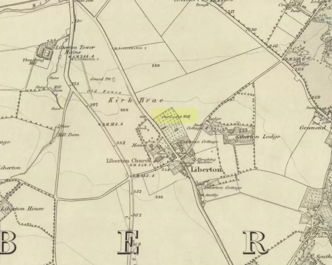
Mentioned in passing by John Geddie (1926)—who was skeptical of any ‘holy’ associations here—this was one of two holy wells in Liberton parish with the same name. Whilst one is on the northwest side of the parish, this was closer to the centre of the village on the piece of land known as the Kirk Brae. It was some 200 yards northeast of the old church at the crossroads, originally dedicated to St. Cuthbert, whose feast day was March 20 — or right next to the Spring Equinox, perhaps when the waters here had greatest virtues.
Highlighted on the earliest OS-map of the region, little is known of it via the written records. Our primary account comes from the Name Book of 1852, where they told:
“An ancient well, known by more ancient settlers as the Christening Well, from the circumstance of this being the only one, from which water was taken in Ancient times for Baptizing; the water being considered the purest; hence it was dedicated to the Virgin.”
Healing Well (destroyed): OS Grid Reference – NT 2511 7322
Archaeology & History
Like many others in the city centre, this old well has long since passed into history. Said by Stuart Harris (1996) to have been “about twenty-five yards east of the eastern corner of Lady Lawson Street”, the Victorian writer Alison Dunlop (1890) told it to be by “a narrow close and an outside stair gave (which) entrance to the Court-house.” It was the focus of much social activity in ages past; and although a number of public wells could be found in this part of the city, south of the Castle, the Westport Well was the most renowned. Miss Dunlop told that,
“…its waters (were) of excellent repute (and) had to satisfy the necessities of all the inhabitants of the district. The early morning never failed to see a long line of water-stoups stretching from it in either direction like the queue at a French theatre door. Not so quiet, however, for tongues, mostly feminine, wagged freely, and the ‘Waal’ news and gossip were then the equivalent for a racy morning newspaper.”
According to her account, the patience of the people collecting the water was exemplary:
“All crowding-in was fiercely resented; gentle and simple had to stand their turn; only the water-caddies had the abiding right of precedence, and satisfied their customers at the moderate rate of two stoupful for a penny. We have already mentioned these ancient aquarian vessels peculiar to Scotland. In the event of a marriage taking place—in which case the bride was responsible for an amount of house plenishing not considered incumbent or even fashionable now-a-days—the ‘stoups’ were invariably purchased by the intending husband. Indeed, the Weetin’ o’ the Stoups was the synonym for the last bachelor supper prior to matrimony. Such festivities are understood to be hilarious, happy, hopeful; and the weetin’ o’ the stoups in Old Portsburgh, as in Old Edinburgh, was sometimes very wet indeed.”
The stone marking the position of the well is situated on the north side of the road at the east end of Grange Loan, a few yards west of the junction with Findhorn Place, at Newington on the south side of Edinburgh. Unfortunately, all that now remains of the well is a red sandstone front with two pieces of metal on each side.
Archaeology & History
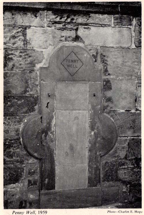
Set back a little into the wall alongside the road, we today see only the architectural memory of this once famous and much-reputed holy well, whose waters sadly no longer flow. Curiously omitted from the primary Scottish surveys on holy wells, it was long known as an important water source by the people of Edinburgh in ages past. The best article on the site was written by W.F. Gray (1962) some fifty years ago, in which he told:
“Built against a garden wall, the Penny Well looks rather forlorn. Now that a plentiful supply of water is in every dwelling, its public usefulness is definitely at an end, though it may slake the thirst of a passer-by. But however that may be, the Penny Well has a long if not distinguished history, though fact and fiction, it is to be feared, are inextricably linked.
“And first, as to its age. There is documentary evidence of the existence of the Penny Well as far back as 1716. In that year Sir William Johnston of Westerhall, Dumfriesshire, disposed to William Dick of Grange three acres of his lands of Sciennes, which are described as bounded on the west by the lands belonging to “said William Dick and the Penny Well.” The well really marked the south-east boundary of the lands of Grange.
“The actual age of the Penny Well is unknown. All that can be positively stated is that it has existed for at least two hundred years… How the Penny Well came by its name is another unsolved mystery. There is a story to the effect that in the earlier half of the nineteenth century an old woman who lived in the cottage opposite the well had charge of the spring and sold the water to wayfarers at a penny a glass. A very plausible story by which to account for the name! Unfortunately its credibility is shaken by the fact that…the spring was known as the Penny Well fully a century before…
“Sir Thomas Dick Lauder, when he took up residence at Grange House in 1832, was deeply interested in the well at the east end of his property. He had it restored and above it placed a tablet with the words, ‘Penny Well’ inscribed on it.
“About 1870, when feuing operations were in progress and there was much digging in the vicinity of the well, the water suddenly ceased to flow. After an interval, however, it again became copious, so much so that it formed a tiny pond in front of an adjoining house. In the hope of drawing off the water, a pit was dug. This led to an interesting discovery. Five feet below the surface, workmen came upon what there seems no reason for doubting was the original trough of the Penny Well. This “interesting and unexpected find” (to quote from The Scotsman) was covered by a large block of hard sandstone. The trough, which was circular, measured 32 inches across and had a depth of fully 1o inches in the centre.
“The Society of Antiquaries made investigations and the opinion was hazarded that “the basin into which the water ran was without doubt a baptismal font,” possibly the one which once stood beside St. Roque’s Chapel, situated at the southwest end of Grange Loan, but long since removed.
“In the (1890s) the Penny Well underwent a second restoration, the Town Council providing £30 for the purpose. By this time however, the spring was found to be impure, but the trouble was got over by substituting the town water.”
Folklore
Penny Well in 1959
Although there are no documents proving with certainty, local tradition reputed this to be one of Edinburgh’s numerous holy wells. It probably was. And whilst W. Forbes Gray seemed at a loss to explain the name of this old water source, it probably comes from the old practice of local people dropping pennies and other offerings into the well in the hope that the spirit of the waters would confer good health or other benefits upon the hopeful pilgrim. Such rites, of course, are very ancient indeed and relate specifically to the animistic spirit-nature of the site. In Mr Gray ‘s (1962) essay on the Penny Well he also had this to say:
“According to one statement, it was a holy well attached to the Convent of St. Catherine of Sienna (which stood at the foot of St. Catherine’s Place), a well whose waters were possessed of miraculous powers of healing those afflicted with blindness, in which case it would be in the same category as the well of St. Triduana at Restalrig, and the Balm Well at Liberton.”
Reputed in times gone by to be one of the never-failing springs, this clear and sparkling water supply would keep bubbling away long after all others in the area had dried-up during summer droughts.
“It is also said that the ubiquitous Mary Queen of Scots, when she visited the religious sisterhood at Sciennes, partook of the waters of the Penny Well. “
Cup-and-Ring Stone: OS Grid Reference – NT 251 696
Archaeology & History
Braid Hills carving
This is a fine-looking old cup-and-ring stone! Although no longer in situ (one of those really important golf courses needed to be built, so it had to go!), the 3 or 4 cup-and-rings seen here, carved at the end of what look like some sort of ‘stalks’, emerging from a distinctive radial under-curve, gave me a somewhat anthropomorphic impression of chaps in a boat — perhaps sailing into the Firth o’ Forth a short distance away! The Scottish Royal Commission (1929) report said the following of the stone:
“In 1897 a boulder of white sandstone with cup-and-ring markings on its surface was discovered on the Braid Hills golf course, and it was later presented to the National Museum of Antiquities. The stone measures almost 3 feet by 1 foot 9 inches, by 1 foot thick and is roughly oblong. The markings comprise seven cups in all, and at least three of these are completely surrounded by a ring and cut by a radial channel.”
Although nothing was said in the RCAHMS account, the stone gives one the impression it was associated with a tomb. And I know it aint the same, but when I first saw this carving, it reminded me of the Ri Cruin carving in Kilmartin, Argyll. It’s the potential “boat” feature that did it for me!
References:
Royal Commission on the Ancient & Historical Monuments of Scotland, Inventory of Monuments and Constructions in the Counties of Midlothianand West Lothian, HMSO: Edinburgh 1929.


 This is the first detailed guide ever written on the holy wells and healing springs in and around the ancient city of Edinburgh, Scotland. Written in a simple A-Z gazetteer style, nearly 70 individual sites are described, each with their grid-reference location, history, folklore and medicinal properties where known. Although a number them have long since fallen prey to the expanse of Industrialism, many sites can still be visited by the modern historian, pilgrim, christian, pagan or tourist.