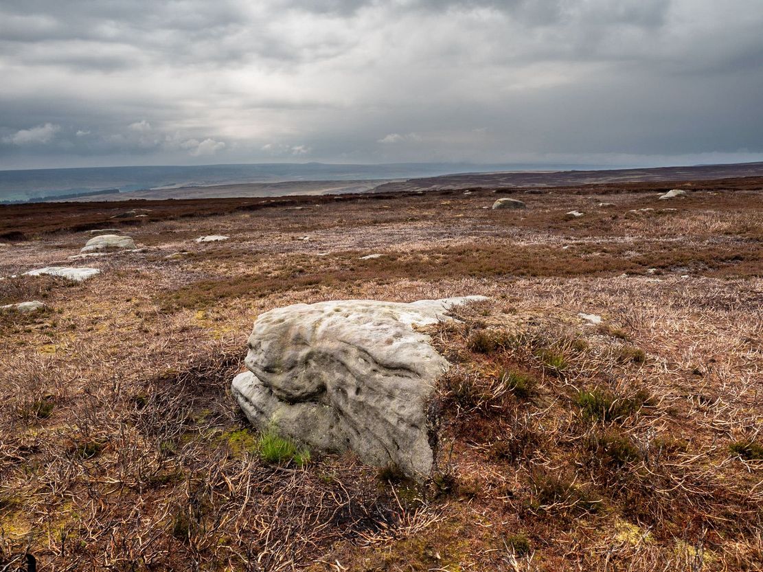
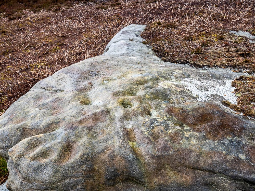
This one really takes some finding. Take the high moorland road running between Lofthouse and Healey villages, and at the very top by the cattle-grid, park up. Walk across the road and walk east. A mile or so on you’ll pass the Shooting Lodge house: keep walking for nearly another mile where another track goes left. Walk down here about ½-mile and you’ll see a crag down the the slope on your right. From here, walk uphill to your left; over the wall, and keep going about 500 yards until the moorland levels out. Hereby is a small outcrop of rocks. Look around!
Archaeology & History
Recently rediscovered by young antiquarian Mackenzie Erichs in May 2021, this flat rock—roughly 5 feet by 3 feet— is one of many amidst the heather which, when fully grown, is gonna be hard to see. This is one of the many petroglyphs possessed with both natural and artificial elements roughly of the same number here.
Upon the mainly southern-side of the stone is a cluster of cup-marks with several on the edges of the rock, most of which are probably natural, or naturally affected. The main cluster of cups—about eight in all—have differing levels of erosion, suggesting differing periods of execution. The most obvious cup is the deep one near the middle of the stone; a group of 3-4 very eroded ones are closer to the edge; and 2-3 three others of varying shallow depths can be seen. One of the cups at the edge of the rock may also have been partially worked.
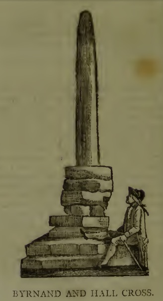
This long lost Cross could once be seen close to the Tudor era Byrnand Hall, which stood on the north side of the High Street. The Hall was demolished around 1780, and replaced by the present building, which is now a political club. The Cross was taken down around the same time, so we’re very fortunate to have a contemporary sketch.
Harry Speight (1906), the Great Yorkshire antiquarian, described the Cross when he was writing of the ‘big houses’ of Knaresborough, saying:
“Another notable old mansion was Byrnand Hall, which stood at the top of the High Street facing Gracious Street, and was rebuilt about a century ago. It was the property and seat for many generations of one of the leading families of Knaresborough, named Byrnand, one of its members being recorder of York in 1573. Opposite the house stood a very ancient stone cross, consisting of a plain upright column, without date or inscription, supported by several rudely-formed stones placed on three tiers or steps. It appears that one Richard Byrnand paid a fine and was permitted to enclose a cross standing on a piece of waste land then lately belonging to Robert Nessfield. The cross may be conjectured to have been either a memorial or boundary-stone. In those days ” it was not enough,” says the old antiquary, Hearne, ” to have the figure of the cross both on and in churches, chapels, and oratories, but it was put also in church-yards, and in every house, nay, many towns and villages were built in shape of it, and it was very common to fix it in the very streets and highways.
“This ancient relic, the site of which is now marked by a brass cross sunk in the causeway, was in after times called the Byrnand Hall Cross, from its proximity to the house of the same name. It stands on the road equidistant between York and Leeds, being eighteen miles from either place.”
At the end of the eighteenth century, E. Hargrove wrote:
“The (Byrnand) family mansion was situated at the end of the High-street, leading towards York. Near it formerly stood an ancient Cross, which being placed on the outside of the Rampart, and opposite to the entrance into the borough, seems to have been similar in situation, and probably may have been used for the same purpose, as that mentioned by Mr. Pennant, in his History of London, which stood without the city, opposite to Chester Inn; and here, according to the simplicity of the age, in the year 1294, and at other times, the magistrates sat to administer justice. Byrnand-Hall hath been lately rebuilt, by Mr. William Manby, who took down the remains of the old Cross, and left a cruciform stone in the pavement, which will mark the place to future times.”
Abbot J.I. Cummins, writing in the 1920s about the Catholic history of Knaresborough, told:
“Of the Byrnand Cross beyond the old town ditch the site is now marked in York Place by a brass cross let into the pavement for Christians to trample on.”
The Cross occupied an important position in the Knaresborough of old, at one of the highest points of the town by the junction of the modern High Street and Gracious Street, this latter being the road down the hill to the riverside and the troglodytic shrines of St Robert of Knaresborough and Our Lady.
Assuming the eighteenth century drawing is an accurate representation of the Cross, it does give the impression of considerable antiquity, and looks to have been 15-16 feet (4.75m.) high. From its appearance it looks like either a prehistoric monolith or an Anglo-Saxon ‘stapol‘ or column, and if it was the latter, it may have been erected to replace an earlier heathen wooden column or sacred tree following the replacement of the old beliefs by Christianity. If so, there may be no reason to deny Hargrove’s speculation that Byrnand Hall Cross once had a similar juridical function to the Chester Inn Cross in London.
References:
Bintley, Michael D.J., Trees in the Religions of Early Medieval England, Woodbridge, Suffolk, Boydell Press 2015.
Cummins, J.I., “Knaresborough,” in The Ampleforth Journal, Vol XXIV, No II, Spring 1929.
Hargrove, E., The History of the Castle, Town and Forest of Knaresborough, 5th Edition, Knaresborough 1790.
Speight, H., Nidderdale, from Nun Monkton to Whernside, London, Elliot Stock, 1906.
Follow the same directions as if you’re going to the excellent Morphing Stone cup-and-ring carving. From the carving, look up the field to the where the dirt-track is and, by the closest gate with a tree near it, walk straight towards it. Roughly halfway between the Morphing Stone and the gate you’ll find — eventually — the small stone in the photo with well-defined cups on it. You might need to wander back and forth until you find it, as there’s many rocks to check out here!
Archaeology & History
Possible cup-marked rock
This small cup-marked stone was rediscovered by Danny Tiernan in the late afternoon of Thursday, August 18, 2011, just as the heavens opened and the rains poured down! With at least one well-defined cup-mark and another two near the edge of the stone where the grasses had grown, this stone probably needs another look at it, as there may be more beneath the surface, much like when we first found at Morphing Stone.
Danny also found and photographed another larger boulder, a bit further up the field closer to the fence, where what may be a single cup-mark is clearly seen living on top of the rock. It’s one of those dodgy English Heritage ones though, so I’ll let those ‘qualified’ chaps check this one out and give it their expertise! It could well be another unrecorded cup-marked stone though…
Takes a bitta finding this one – especially a this time of year when the bracken’s high – but it’s worth the walk. You’re probably best finding your way to the open-air carving on the slopes above Westcliff Farm, the Guisecliff Wood 626 carving (it’s pretty easy to find). From here, walk eastwards across the top of the two fields until you hit the old gate that take you back into the woods. Now it gets difficult! Walk less than 100 yards in the same direction, if you’re lucky, along the small footpath that runs pretty level through the trees, keeping your eyes peeled for a large sloping rock above you. I’d say that it’s probably best to start checking the relevant rocks (large ones) after 50 yards in the trees, just to be on the safe side. If you aint been here before it’s probably best to check it out at the end of Winter or during Spring time. Good luck!
Archaeology & History
As noted by several people in our visit here the other day, some aspects of this carving are similar in design to the Tree of Life Stone on the eastern edge of Askwith Moor, 10 miles south of here. But the features on this large carved rock have intriguing elements of their own here: not least of which is the large square ‘box’ into which a cluster of otherwise normal cup-and-rings are enclosed. It’s a unique feature in prehistoric carvings in this part of the world — although such ‘box’ motifs can be seen further north at Dod Law in Northumberland.
The fainter cup-and-ringsBoughey & Vickerman’s 2003 drawing
There are two distinct sections of carvings on the stone, both of which have a similar tree-motif patterns, but the boxed one grabs your attention more once you’ve sat with the stone for a while. The other small cluster of cups are a little more difficult to notice, but once you see them they almost grow into life! You can just make out the surrounding rings and lines around some of these fainter cups, which I tried to capture in the photos (but without much success).
Our visit here didn’t pass without some voicing the thought that ‘box’ section could have been added at a much later date — perhaps a Victorian addition? But we could be way off the mark with that one!
There’s every likelihood of other carvings being found in and above the woodlands here, though any further exploratory excursions here can wait till winter time, as the Nature’s summer growth here is considerable and covers most of the rocks in green. The carving was first described in Boughey & Vickerman’s (2003) text as a
“Very large rock with extensive flat surface on which there seems to be two separate designs. Seven cups are joined in a branch-like pattern, the whole within a square groove from which the ‘stem’ of the branch just protrudes; away from this is an approximately linear feature with three cups enclosed by linked rings at one end and then six more cups with a partial ring.”
If you’re a rock art enthusiast, or a real healthy heathen, this site is well worth checking out!
References:
Boughey, Keith & Vickerman, E.A., Prehistoric Rock Art of the West Riding, WYAS 2003.
Take the same directions as if you’re visiting the Eastwoods Cross base and cup-marked stone, but at Eastwoods Farm itself, walk downhill following the field-wall, past the large house, then through the first gate you come to. (it’s got a ‘private’ sign on it and has some handy bulls in the field – but ask at the house and the folks there are friendly) Following the footpath along the top of the field, cross the small stream, then head across the next field to the gap in the wall. You’re here!
Archaeology & History
Boughey & Vickerman’s sketch
One of a cluster of cup-and-ring stones around the Bryan’s Wood and Eastwoods area, this carving is well worth a visit, but can be covered in shit and muck as the bulls pass through the gap here on their daily amble. If the daylight isn’t good here, it can be difficult to see the carving – and when we visited the place the other day, the cloud was low and the heavens were ready to open, so our luck was out for a change! There are a number of cup-and-rings plus a double-ring, fading their ways around the more defined cup-markings. The stone appears to have been found in the 1990s, but records of it are scant. Boughey & Vickerman (2003) fail to tell the origin of the name, nor when or who rediscovered the site. Their description of the carving tells simply:
“Large flat smooth rock sloping slightly to E. Thirteen possible cups, one with partial double ring and four with partial single-rings; three ringed cups have grooves leading from them.”
Several other excellent cup-and-ring carvings can be found around here. The hugely impressive Morphing Stone and a prehistoric lightning-carving can be found three fields away to the south, past the trees on the other side of the stream.
Folklore
Close-up of the stone
The title of ‘fertility stone’ seems a modern one, although word has it that it relates to Beltane fertility rites. However, I can find no documentary information relating to this, and the people at Eastwoods Farm and adjacent house know nothing to account for it.
References:
Boughey, Keith & Vickerman, E.A., Prehistoric Rock Art of the West Riding, WYAS 2003.
From Pateley Bridge take the B6265 road towards Grassington, turning left just a coupla hundred yards over the river bridge, towards Bewerley. Go through the hamlet and take the second on the right, up the steep zigzagging lane. A half-mile up the hill, watch out for the track onto Westcliff Farm. Go along here and onto the footpath, then as you walk through the field, look uphill where the long wall runs into the trees, and you’ll see a rock in the walling near the top. That’s it!
Archaeology & History
Just over the edge of the northern section of The Intakes at the western end of Guisecliff Wood, on a large rock in the walling near the very top of the field above Westcliff Farm, we find this little-known but very impressive cup-and-ring stone.
Close-up of some cupsBoughey & Vickerman’s sketch
Upon first sight the rock was aptly described by Danny Tierney as being like a Viking Hogback Stone with cup-markings along the sloping side of the long rock as it grew into the drystone walling. He had a point! It’s a curious carving (how many times do I say that!?), with the majority of the cup-marks and lines etched into the south-sloping face of the rock. Other cups found further down the stone stretch along the eastern side towards ground level; and we have a small line of cups etched onto the normal horizontal face halfway along the stone.
The carving was rediscovered by Stuart Feather in the ‘Sixties and was all-but-forgotten until Boughey & Vickerman (2003) rejuvenated it in their catalogue. They told it to be:
“Large rock of coarse grit lying with long uneven surface E to W, at ground level to S and E, but with high N and W faces. Up to eighty cups but some may be due to pebbles or other natural causes; one cup has two half-rings which, like some grooves visible, suggest a now incomplete design.”
The fascinating ‘boxed’ cup-and-ring stone of Guisecliff Woods 629 can be found less than 200 yards east of here, in the trees, and is certainly worth seeking out!
References:
Boughey, Keith & Vickerman, E.A., Prehistoric Rock Art of the West Riding, WYAS 2003.
Feather, Stuart & Hartley, C.E., “The Yorkshire Archaeological Register, 1964: Bewerley. W.R.”, in Yorkshire Archaeological Journal, volume 41, 1965.
From the road between Pateley Bridge and Summerbridge, the B6165, turn down to Glasshouses, following the road through the village and round past the reservoir; then as the road bends, keep to your left and go the steep zigzaggy hill, stopping where a gravel parking space is on the right-hand side of the road, by the bend. From here, cross the road and walk up the footpath to Yorke’s Folly. Go over the wall and along the footpath by the wall (the Nidderdale Way) for a coupla hundred yards. Then turn into the heather about 50 yards up from the walling. Look around!
Archaeology & History
Heyshaw Moor cairn no.1
There’s no previous reference to this site. It was found yesterday and is one of several such small heaps of stones (cairns) found along the flat ridge of moorland just south the hugely impressive of Guisecliff Crags on the northern edge of Heyshaw Moor. The one illustrated here is probably the best of the several we found and may be indicative of a previously undiscovered cairnfield. On a visit to the western side of the moors a few months ago we found another small cluster of similar cairns in very good condition, much like the one pictured here. It would appear to be prehistoric in nature — although the existence of an old track that ran nearly 20 yards to the west may indicate its previous use as a marker cairn. On the slopes below here (north) there are several examples of cup-and-ring stones, which tend to indicate the proximity of prehistoric graves. This cairn could well be such marker.
We also found evidence of other early human remains on this ridge and further up the moor (walling, rectangular building, possible cairn circle), but there appears to be no literary information explaining its nature. Further visits are needed here.
From the bottom of Pateley Bridge, just out of town take the left turn to Bewerley and go through the village; or from Glasshouses follow the road over the River Nidd and round. Both ways take you to meet the steep and winding Nought Bank Road, which you should follow all the way to the top of the moorland hill. You can just park up by the footpath taking you east. Then cross the road and walk west on the dirt-track to Rowan Tree Crags. 100 yards along, the gentle sloping moor on your left is the Old Wife’s Ridge.
Archaeology & History
The academic history of this moorland is poor, save occasional notes about lead mining and quarrying (Jennings 1967). Speight (1894) describes the finding of large pieces of lead-worked Roman inscriptions nearby that were found in January 1735 — one of which had the letters ‘BRIG’ cut into it, thought to be a referral to the land or deity, Brigantia. Examples of prehistoric rock art occur at nearby Guisecliff Woods, due east, but there are no specific notices about the archaeology of this hillside.
Long overgrown stone at Old Wife Ridge
When we visited the place yesterday, much of the heather had been burned (the previous year) and we found two stones which looked suspiciously as if they had stood upright in the past, and may have had played some part in the naming and myth of the Old Wife on this part of the moors. I can find no other records of any remains here.
Folklore
References to the Old Wife scatter our northern lands and invariably refer to an aspect of the heathen Earth Mother of our peasant ancestors, particularly in Her aspects of winter and early spring. In Scotland and Ireland She was commonly known as the cailleach. Sadly I can find no extant lore relating to Her mythic aspects in the landscape on these hills. A field-name to the south, Nanny Black Hill, may have related to the Old Wife.
References:
Jennings, Bernard (ed.), A History of Nidderdale, Advertiser Press: Huddersfield 1967.
o’ Crualaoich, Gearoid, The Book of the Cailleach, Cork University Press 2003.
Speight, Harry, Nidderdale, Elliot Stock: London 1894.
From the lovely village of Summerbridge (near Pateley Bridge), go up the steep Hartwith Bank road, going straight across at the crossroads for another few hundred yards, passing the old tombs of Graffa Plain on your right…and they’ll start appearing on your left-hand side (west). Do not go into the expensive National Trust car-park. Instead (if you’ve already gone too far), about 100 yards before the Car Park you’ll find a small dirt-track on your left a short distance away. But if you drive past the rip-off car park, another 100 yards on there’s another spot where you can easily park up on the right-hand side of the road. Then cross the road and follow y’ nose…
Archaeology & History
The OS grid reference given above is an approximation — for obvious reasons. This is a huge area that’s covered by Britain’s finest natural megalithic features, obviously sculptured by Nature Herself — though many are the historians who sought to give Druids the credit here. God knows how! The area over which these magnificent rock sentinels live covers some 60 acres and is some 1000 feet above sea level. The view from the hill around which the encircling parade of rocks guards is excellent, allowing our eyes to catch focus on the distant lands of Whernside, Simon’s Seat, York Minster, the Cleveland Hills and Kilburn’s white horse. It’s quite a view.
Easternmost Rocking StoneIdol Stone (Godfrey Higgins 1826)
But this tends to be overlooked when you first visit the place, as the rocks which surround and walk alongside you overwhelm with impressions not encountered before. To those with spirit, you’ll be bouncing and running all day here, clambering upon rocking stones, jumping between dodgy gorges that await falls, and just aching to climb pinnacles that deny you. But then, if you need the selfishness of silence, this arena will only grant such solace when the rains are about, or dense fog and low cloud keeps others from this haunting amphitheatre. And it’s not surprising… The mass of rocks contort into the most beautiful and curious simulacra, which would not have gone unnoticed, nor deemed unimportant in the sacred landscape of our ancestors…
Brimham Rocks have been written about since the 17th century, though they didn’t receive the serious attention of outsiders until the 19th, when numerous Victorian writers — from antiquarians and geologists, to archaeologists and Druids — got to hear about the place. And by the beginning of the 20th century, a veritable mass of articles had been written in journals and travelogues of all persuasions! These quiet Yorkshire Rocks had become truly famous!
Brimham Rocks (Walbran 1856)Old Woman and her consort
A lengthy essay was written in the distinguished archaeology journal of its time, Archaeologia, by northern historian Hayman Rooke (1787), who thought that some of the rocks here had been tampered with by the druids; with the legendary Cannon Rock in particular possessing oracular properties. The site as a whole was, he posited, a temple for Druids in ancient days. Certainly the place would have been deemed as sacred, whether by the druids or our more remote neolithic and Bronze Age ancestors.
Harry Speight & his mates, c.1890
In Harry Speight’s magnum opus, Nidderdale (1894), he described these rocky giants as best as he could, admitting as others before and since, that no mere words can convey the impression that only a personal encounter liberates, saying:
“The Brimham Rocks are among the greatest natural wonders of Yorkshire, and many have been the theories from time to time advanced as to the cause of their extraordinary aspects… The resemblances to natural and artificial objects are most striking. There we have the Elephant Rock, the Porpoise Head, the Dancing Bear (a very singular, naturally-shaped specimen), the Boat Rock, showing the bow and stern completely, etc. Then there is the great Idol Rock, a most mysterious-looking object, of almost incredible size and form. It is a perfectly detached block, fully twenty feet high, weathered along face joints into three roughly circular pieces, each from 40 to 50 feet in circumference, piled one above the other; the whole mass, weighing by estimation over 200 tons, being poised on a pyramid 3½ feet in diameter; the pivot itself supporting this immense column having a diameter of barely 12 inches.
“East of the guide’s house are the famous Rocking Stones, consisting of a group of four rocks, which were discovered to be movable in the year 1786. The two on the west side weighing approximately 50 and 25 tons, require but little force to vibrate, while those on the east side, though much smaller are not so well poised and do not move readily. Each of the larger stones has a basin-like cavity on the top, and a kind of knee-hole open to the north, said to be the work of Druids. Close to the Rocking Stones are the appropriately-named Oyster-shell Rock, and the Hippopotamus’ Head. Turning now some thirty yards north of the Idol Rock we ascend Mount Delectable, where is the agreeable Courting or Kissing Chair, happily at not too close quarters with the above Hippopotamus’ Head and Boar’s Snout. The Chair consists of a single seat, but why it should be so called, I had better leave the amorous lover to solve. West of these is the more sober Druid’s Reading Desk, with its church-like lectern on a stout stone base. The we come to the Lover’s Leap, a gigantic and abrupt face of beetling crag, weathered to the west, and rising to a height of 60 to 70 feet, with three immense fragments balanced in a very remarkable manner at the summit. The rock is in tow principal sections, and an iron hand-rail has been fixed across the chasm to enable visitors to look down from the top. Further south are the Frog and Tortoise Rocks, the latter presenting from one point of view a capital resemblance to a tortoise creeping up the face of the crag towards the imaged frog. A little below this is a good imitation of a cannon, projecting from the edge of the cliff. In addition to these singular resemblances there are many others which the guide points out, such as the Yoke of Oxen, Mushroom Rocks, Druid’s Oven, Dog’s Head, Telescope, and the curiously perforated Cannon Rock, etc.”
In a later work, Speight (1906) also mentioned the existence of a Druid’s Circle some 300 yards west of the main natural temples, but this site appears to have been destroyed. Thankfully the large standing stone on Hartwith Moor, a mile to the south, can still be found upright…
Folklore
Idol Stone (Hargrove 1809)
In folklore, there’s little surprise this place was held by just about every 18th and 19th century historian as a ‘druidic site.’ But more interesting – in the light of Paul Devereux’s (2001) work on acoustic archaeology – is what Edmund Bogg (c.1895) said of these huge contorted stones:
“In bygone days these immense stones were supposed to be the habitation of spirits. The echo given from the rocks was said to be the voice of the spirit who dwelt there, and which the people named the Son of the Rocks. From a conversation we had with the peasantry not far from here, it seems the ancient superstition had not yet fully disappeared.”
This is precisely the notion of spirit given to rocky places elsewhere in the world, where the very echo was perceived as the ‘voice of the rocks’. Meditate on it a bit, in situ. (a fine summary of this notion and its implications — which has crept into archaeology of late — can be found in Paul Devereux’s work, Stone Age Soundtracks)
One of Brimham’s southwestern rocks was known as the Noon Stone when Mr Rooke (1787) came here. There are many stones with this name scattering Yorkshire and other northern counties, each with the same mythic background: that the sun casts a shadow from it at midday to indicate the time of day. Of this Noon Stone Mr Hooke also told us that,
“On Midsummer Eve fires are lighted on the side. Its situation is apposite for this purpose, being on the edge of a hill, commanding an extensive view. This custom is of the most remote antiquity.”
On the very southern edge of Brimham’s Rocks (some might say beyond their real border) is the Beacon Rock — and it is aptly named: as in the year 1887 on the day of Queen Victoria’s Jubilee, a great beacon fire was lit here, signalling to others in the distance. Its title however, pre-dates Victoria’s Jubilee, though we don’t know how far back in time it goes…
…to be continued…
References:
Bogg, Edmund, From Eden Vale to the Plains of York, James Miles: Leeds c.1895.
Devereux, Paul, Stone Age Soundtracks: The Acoustic Archaeology of Ancient Sites, Vega: London 2001.
Grainge, William, The History and Topography of Harrogate and the Forest of Knaresborough, John Russell Smith: London 1871.
Harrison, William, A Descriptive Account of Brimham Rocks in the West Riding of Yorkshire, A. Johnson: Ripon 1846.
Michell, John, The Earth Spirit: Its Ways, Shrines and Mysteries, Thames & Hudson: London 1975.
Michell, John, Simulacra, Thames & Hudson: London 1979.
Rooke, Hayman, “Some Account of the Brimham Rocks in Yorkshire,” in Archaeologia journal, volume 8, 1787.
Speight, Harry, Nidderdale and the Garden of the Nidd, Elliot Stock: London 1894.
Speight, Harry, Upper Nidderdale, with the Forest of Knaresborough, Elliot Stock: London 1906.
Walbran, John Richard, A Guide to Ripon, Fountains Abbey, Harrogate, Bolton Abbey, etc, Johnson: Ripon 1856.
Take the road up to Brimham Rocks from Summerbridge; crossing the little crossroads, then keep your eyes peeled for the singular farmhouse on your right. Just beyond this, on your right, you’ll notice some small moorland opens up and reaches gently down the slope for some distance. Go along the footpath for 100 yards or so, then into the heather to your right, for 60 yards or so (as if you walking towards the farmhouse and small crags). This is where the following sites could be found. (when we visited Brimham recently, unfortunately sunfall stopped us having a proper wander here, so the status of the site/s remains unknown to us)
Archaeology & History
This little-known and possibly destroyed prehistoric site — less than a mile north of Standing Stone Hill and just a coupla hundred yards south of the legendary Brimham Rocks — has been described by several antiquarians from the early 19th century onwards. It’s an intriguing place, deserving of much greater antiquarian attention. Ely Hargrove (1809) appears to be the first who mentions prehistoric tombs here, though his sense of direction implies another site (unless he just got that part of it wrong?). Along with “several small tumuli or carns” near another section of Brimham Rocks themselves, he told there to be,
“Several large tumuli; one of which about 80 yards west of the great Cannon, measures 150 feet in circumference. It is worth remarking that the place where most of these tumuli are found is, at this day, called Graffa Plain, i.e., the Plain of Graves.”
These ‘tumuli’ were again mentioned briefly in passing by one ‘D.N.H.’ in the Gentleman’s Magazine of November 1823. The great Knaresborough historian William Grainge also described cairns here. They were then highlighted on the very first Ordnance Survey of the region in the 1850s and shown as “Supposed tumuli.” Eventually, at the turn of the 20th Century, they were explored at the behest of the local land-owner by Mr L.A. Armstrong. His description of what they found here is intriguing and well worth reproducing in full:
“By permission of the Right Hon. Lord Grantley, I was enabled to make a careful examination of two of the ancient burial mounds of ‘ Graff a Plain,’ Brimham Moor, on Tuesday, August 4th, 1908.
“Mound No. 1, of circular form, and about 12′ o” in diameter, is situated about 150 yards north-west of the first large group of rocks, upon the south-eastern boundary of the moor, and about 50 yards south-east of the trackway leading to ‘ Riva Hill Farm,’ and it occupies the summit of a slight hillock, upon a comparatively level portion of the heath, which rises rapidly to the south of it in a bold sweep, terminating in the outstanding rocks of Graffa Crags and Brimham Beacon.
“The entire absence of any heather upon the mound, and the profusion of bright green bilberry plants which covered it and at the same time rendered its outline more noticeable, told plainly of a different character of subsoil from that of the surrounding moor ; but prominent as the mound appeared, its actual elevation was deceptive, being barely two feet above the natural level, and the uneven character of the upper surface suggested previous disturbance to be more than probable. A few attempts to pierce the crown, however, proved it to be a cairn, constructed of large stones, and accounted for the prolific growth of the rock-loving bilberry which overspread it, as well as for the uneven character of the surface.
“The thick green covering was carefully stripped off in lengths and placed on one side, and the few inches of vegetable earth removed, revealing the cairn in an almost perfect state, formed of a series of large stones placed methodically in concentric rings, each stone slightly inclined towards the centre, and the whole mass interlocked together by their own weight. Large stones were placed around the outside forming the enclosing circle, which is almost invariably found in the case of earth-built tumuli, and a few of these had been visible before the covering was stripped.
“The construction of the cairn rendered it necessary to remove the stones from the outer ring first, and to work gradually towards the centre where the burial, if such existed, might be expected to lie. This proved no easy task, as the stones were so tightly wedged, and had each apparently been specially selected for the purpose. Almost without exception, they were about a foot in diameter, oblong or oval in form, and three to five inches in thickness, with flat surfaces and rounded edges. No marks of tools were visible on any, but all alike were either water-worn, or had been especially rubbed to their present form. The stone itself was the Millstone Grit of the surrounding moor, but fragments of stone of the form composing the cairn are not now to be found thereon readily, although a careful search might reveal such. Personally I am inclined to think that they have been transported from a considerable distance; that great care has been exercised in their selection is indisputable.
“When nearing the inner radius of the cairn, small fragments of charcoal were noticeable, but they were by no means in large quantities. There was also a layer of fine grey sand an inch or two in depth, which had apparently been spread over the natural surface of the ground, and the stones bedded therein. Sand of this kind is abundant in the vicinity of the rocks upon the moor.
“In the centre, large pieces of stone were piled around a rough circle of about 3′ 6” extreme diameter, and within these, large and small stones, all of the form previously noticed, were laid more or less upon their flat surfaces, and amongst them the grey sand and charcoal were very evident; pieces of the latter up to an inch square, being found.
“Upon the gradual removal of this central mass of stones, the presence of the unmistakable black ‘barrow earth’ became evident in a slight layer, perhaps an inch or an inch and a half in thickness, and spread over the whole area within the inner ring, the bottom of which had been paved with large flat stones. Amongst this earth very slight traces of a greyish white paste-like substance were”] visible, probably the decomposed remains of the bones after calcination. The deposit was carefully gathered together. Its removal bared the large stones forming the bottom of the grave, and these proved to be two in number, the largest being about 2′ o” across, and of a somewhat angular form ; strikingly different to those composing the cairn itself, for the edges were rough fractures, not rounded in any way. Apparently the surface soil had been removed from the ground upon which the cairn was built, for the upper face of the two stones forming the bottom was level with the natural ground surface adjoining, so far as could be ascertained, and these had apparently been laid down for the reception of the deposited remains.
“As there was every reason to believe that some portion of the ashes might have been placed in an urn, efforts were made to raise the stones above mentioned in hopes of a discovery. This was by no means easy, but by care and perseverance, it was at last accomplished, but only to meet with disappointment. Immediately beneath was a slight layer of ashes upon the natural ground surface, which latter showed very evident signs of fire, the bright yellow sand composing the substratum being calcined to a dark red colour for quite 2” in depth. This sand was very stiff and compact. The most diligent search failed to reveal any trace of a hole or other disturbance at any point, or of any implements which might have accompanied the body, either upon the surface or amidst the cairn.
“One stone found amidst those immediately covering the deposit, was remarkable because entirely different from all the remainder composing the cairn, and appeared to have been shaped with some definite object in view. It was a fragment of hard sandstone, in the form of a truncated pyramid, the sides and top being roughly fractured to shape, but the base was quite smooth, and bore marks of friction. The base measured 6″ x 5″, and the height about 4½”. This might have been used as a crushing and grinding stone for grain, or for rubbing purposes, but careful search failed to reveal its companion slab. With this exception, nothing was found that could be considered as having been fashioned for use, and there was nothing to throw any light upon the probable period of the cairn’s erection.
“The second tumulus examined is situated about 100 yards south-west of the first. It was of rather irregular shape, and appeared to have been somewhat disturbed, but the original diameter had probably been about 9′ o”. Upon examination, it also proved to be of the cairn type, and apparently similar to that previously opened, but it had been disturbed throughout at some distant period, and no trace of the deposit could be found, although the yellow sand forming the subtratum was noticeable, calcined over the whole area as before. There were also traces of charcoal. It is remarkable that amidst the smaller stones of this cairn another ‘ rubbing stone ‘ was found, almost identical with that in the former one, and similarly, this proved to be the only ‘ find ‘ of any description bearing certain traces of man’s handiwork.
“Although somewhat disappointing not to be able to assign the erection of these cairns to any definite period, yet their examination proves valuable for two reasons. First it places beyond any question the nature of the mounds scattered over this portion of Brimham Moor, which is known by the name of ‘ Graffa Plain,’ a name which the late Mr. William Grange translates as ‘ the place of graves ‘ — significant in itself, though he at the same time casts a doubt upon the formation of the mounds in question being anything other than natural. The identity of the grave mounds being established, they prove that a settlement of primitive man of no small magnitude must have been located somewhere in the vicinity.”
The word ‘graffa’ seems to be the plural for ‘graff’, which the english dialect magus, Joseph Wright (1900), convincingly assures us to derive from the old english, “græf, a grave, trench.” This seems confirmed by the common finding of ‘graff’ in regional dialects from Yorkshire, Lancashire and other northern counties, where it relates specifically to ‘graves.’ A variation on the word, as cited above, finds ‘graff’ occasionally relating to “a ditch or trench; a channel, cutting; a hole, pit or hollow.” The usually helpful A.H. Smith (1961-63) was curiously silent on this place-name; but local historians Grainge, Walbran and others tell us that Graffa Plain is simply “the plain of the graves.”
I know of no other accounts that have explored this site. Does anyone have any further information about this place?
References:
Armstrong, A. Leslie, “Two Ancient Burial Cairns on Brimham Moor, Yorkshire,” in The Naturalist, March 1909.
Hargrove, Ely, The History of the Castle, Town and Forest of Knaresborough, Hargrove & Sons: Knaresborough 1809.
Smith, William, “Yorkshire Place-Names,” in W. Smith’s Old Yorkshire – volume 1 (Longmans, Green & Co.: London 1881).
Wright, Joseph (ed.), English Dialect Dictionary – volume 2, Henry Frowde: London 1900.


")


")
