From Broadford town, head northwest outta town up the A87 for a mile, turning left and stopping by the electricity station just 100 yards along. Follow the line of cables down, SE, through the trees, dead straight for about 600 yards (crossing the large stream about halfway) till you notice an open gap through the trees on your right where, 40 yards in, there’s a large circular arena which has been kept aside amidst which a scattered mound is clearly visible. In this opening in the trees…this is where the tomb/s rest…
Archaeology & History
Sited a mile east on lowlands beneath the shadow of Beinn na Cailleach mountain, with its host of heathen legends and lore, is reputed to be the prehistoric remains of an important ancestral burial site, under dominion of the cailleach’s eye. In Audrey Henshall’s (1972-2) magnum opus she describes the remains of what may be two separate tombs here as “difficult to interpret”; even “questioning whether they do in fact represent the ruins of a chambered cairn” as has been ascribed. The site is still included in the Canmore survey, where they cite the same reference as I do here, but add no additional data to Henshall’s query. There is obviously something to be seen here, but until excavation of the site has been done, the exact nature of what lies here cannot be clarified. Miss Henshall wrote:
“There is a setting of stones forming about a third of the west side of a circle which would have a diameter of about 30ft if complete; its greatest N to S measurement is 23ft. The stones are thin slabs 4 to 5in thick, up to 3ft 6in long, set on their long sides and projecting up to 2ft above the turf. The stones have probably been reduced in size due to natural fracturing as the stone readily flakes away. Within this setting, which might be interpreted as the kerb of a cairn, there is a rise of about 1ft above ground level and the grass grows greener, but except for this and a number of boulders lying about the site, there is no sign of cairn material. This is curious as there is no obvious reason for removing it.
“Inside the ‘kerb’ there is a horse-shoe setting of five similar slabs, just visible except for two on the S side which project 1ft 2in due to some peat on their N side having been removed. The enclosed area is 7ft wide by 7ft 6in long, open on the E end. On this side, 14ft from the W end of the setting, is a larger stone, set on end, 2ft 8in high. This might be regarded as a portal stone except that it is set opposite the centre of the open end of the horse-shoe setting, and there is a low thin slab projecting westwards from the middle of its W face. E of this there lie a number of flat slabs and boulders, the larger (some measuring 3ft 8in by 3ft and 4 by 2ft) marked on the plan, but they do not suggest the form of the original structure.
“A stone is set radially to the kerb, 15ft 8in to the N. It is on its long edge, 4ft 11in long and 2ft 2in high. Twenty eight feet S of the kerb there is a circular setting of small boulders, 6ft 6in across inside, and part of another concentric setting can be traced 6ft outside these.”
References:
Henshall, Audrey, The Chambered Tombs of Scotland – volume 2, Edinburgh University Press 1972.
As you drive down the A87 road towards Broadford from the Kyle, just before Breakish there’s a small road on the left that runs down to Glen Arroch, where the forest lines the hill. A couple of miles beyond the end of the forest, watch out for the TV mast on the slopes on the right-hand side of the road. Stop here and go up the slopes on the left-side of the road (north), to the peak of Sgurr na Coinnich; and once here you’ll see the high rocky peak of Beinn na Cailleach a half-mile to your northeast.
Folklore
The legend of this sacred mountain was described at some length in Otta Swire’s (1961) excellent work on the Isle of Syke. She wrote:
“”As you drive down the road towards Broadford, three peaks can be seen to the north; the first two are Beinn na Greine (2,000 feet) and Scurr na Coinnich (2,401 feet); the third and most northerly is Beinn na Caillich (2, 396 feet). This last must not be confused with the Beinn na Caillich near Broadford, which is one of the Red Cuchullins although, just to make it more confusing, on the summit of our Beinn na Caillich, as on that of her larger sister, tradition has placed a woman’s grave. This time it is that of a giantess, one of the Fiennes: beneath her body is a large crock filled with gold and jewels, for she was a great lady, no less than Grainnhe herself, wife of Fionn, and at her burial every man of the Fiennes, for love of her and of their leader, cast their rarest jewels into the earthenware crock to do her honour. Her story, as is so usual in Celtic legend, is a sad one. Grainne is the daughter of the King of Morven and is reputed the fairest and truest princess in all Alban, so the Grey Magician, who hates all that is good, carries her off. One day, as Fionn and his men rest after hunting, an old, old woman, wrapped in the red mantle that denoted royal blood, comes to him, tells him of the theft of Grainnhe and begs him to rescue her. He agrees, whereupon she gives him a fir twig and three small pebbles, all highly magic; she then goes out of sight ‘on an eddy of the western wind, growing smaller as she went until she seemed no bigger than a butterfly, a honey bee, a red spider on a thin rope of its web, and a speck of dust in the sun’. Fionn sets out and after many adventures, during which he is assisted by several talking animals, he finds the Grey Magician’s palace and escapes with Grainnhe. Thanks to the old woman’s gifts, forests and mountains rise behind the fugitives, but before they can reach the Red river, to cross which is safety, the Magician overcomes the old woman’s charms. They reach the river bank only to find they cannot cross, and Fionn’s magic is exhausted. But Grainnhe has a jewel, a charm against death; as long as she wears it in her hair no evil can harm her; alternatively it will give her one wish and vanish. She takes it from her hair to wish for a boat and immediately sees, as in a vision, the fate to which she will condemn herself if she gives up her talisman. But Fionn is in peril through his efforts to save her, and already she loves him, so she lays the jewel on the water. A boat at once appears and takes them to safety.
Fionn and Grainnhe are married and live in great happiness until Grainnhe’s son is about to be born. Then come messengers to Fionn to tell him that sea-pirates are attacking his small dark-skinned allies, the Sons of Morna, who have sent to remind him of his pledge to assist them. Fionn longs to remain with Grainnhe but will not break his vow. He and his men spend three days defeating the sea-pirates and when he returns Grainnhe and her baby are gone, carried off by the Grey Magician. Fionn learns from his ‘tooth’ that she has been turned into a hind. He searches for her for many years, but she has been sent to run with the deer in lone Glen Affaric and he never finds her. Twelve years later, when the Fiennes are hunting, their hounds pick up a scent and follow it to a small copse; Bran, who is leading, is the first to enter it, whereupon, to the surprise of all, he turns at bay, teeth bared against the Fiennes and his fellow hounds of the pack and will allow no one but Fionn to pass him. Fionn finds him guarding a wild boy, with long hair and wild, beautiful, frightened eyes, who can make only such sounds as deer make. Fionn adopts him and teaches him human speech. Needless to say, he is Grainnhe’s son, but Grainnhe, the beautiful white hind of whom her son talks, is never found. After her death the Grey Magician permits her son to take her body, once more that of a woman, for burial, and the Fiennes make her grave on the summit of Beinn na Caillich, where she once ran as a hind.
It is recounted of this boy that he had in the centre of his forehead a tuft of deer’s fur where his mother’s tongue had licked him, and that it was from her that he got his gift of poetry. Once he was shipwrecked on Fladda and a party of hunters on the island offered him a share of their venison stew, to whom he made indignant reply: ‘When everyone picks his mother’s shank-bone, I will pick my mother’s slender shank-bone.’ The boy was Ossian.”
References:
Bernbaum, Edwin, Sacred Mountains of the World, Sierra Club: San Francisco 1990.
Swire, Otta F., Skye: The Island and its Legends, Blackie & Sons: Glasgow 1961.
Seems rather daft giving directions for a mountain, but… For incomers, cross the bridge onto the island and keep on the A87 road to Broadford. A couple of mile the other side of the village westwards, take the small left turn in the trees and go to the dead-end. The hill reaching up above you (west) is the legendary mountain to walk up!
Folklore
Beinn na Cailleach
This giant old mountain has been associated with the primal female creation figure, the cailleach, for many a moon. And strangely – for me anyway – I’ve not ventured to sleep with this old place in my passings here as I usually do wherever the cailleach resides.
It doubtless has many more tales than the one A.A. MacGregor (1937) mentions in his superb Peat-Fire Flame. Here he tells the story of,
“the cairn situated on the summit of Beinn na Cailleach, not far from Broadford… This cairn is believed to mark the site of burial of a Norse princess who died at Ord. On her deathbed this princess commanded her attendants to convey her, when dead to the top of Beinn na Cailleach, and to bury her there, in order that she might lie in the wake of the winds from Norway.”
MacGregor then follows the tale with a lovely note on some boring old dood he obviously had little respect for, saying:
“It is the traditions associated with this cairn that MacCulloch, the geologist, in his Description of the Western Isles of Scotland, asks to be excused from repeating, since he considers them, one and all, to be unworthy of regard. But, then, MacCulloch was a most tiresome fellow; and he seems to have imbued most of his writings with something of the same tiresomeness”!
On the lower northeastern slopes of this great mountain we find another of the old woman’s abodes, the ‘Lochain Beinn na Cailleach’, where this great hag would no doubt wash her linen, as many old myths tell she did at other pools of the same name.
A slightly different version of the folktale was told by Archibald Geikie in his Note-book of a Field Geologist from 1858:
“The top of Beinn na Cailleaich is flat and smooth, surmounted in the centre by a cairn. Tradition tells that beneath these stones there rest the bones of the nurse of a Norwegian princess. She had accompanied her mistress to “the misty hills of Skye,” and eventually died there. But the love of home continued strong with her to the end, for it was her last request that she might be buried on the top of Beinn na Cailleaich, that the clear northern breezes, coming fresh from the land of her childhood, might blow over her grave.”
An early essay in the Gentleman’s Magazine in 1841 tells the grave atop of the mountain to have been the resting place of the Norwegian King Haco’s wife or his nurse. Derek Cooper (1970) meanwhile told us that whilst the cairn was “erected as a memorial to a Skye chieftain,” the cailleach of the mountain, or “the old woman is reputedly Saucy Mary, who laid a chain between Kyle and Kyleakin to exact toll from passing ships.”
There are other mythic place-names scattered around the edges of this mountain with hints of ancient female deities, or pagan goddesses — whichever way one cares to see them.
References:
Cooper, Roy, Skye, Routledge: London 1970.
Geikie, Archibald, The Story of a Boulder, MacMillan: London 1858.
MacGregor, Alisdair Alpin, The Peat-Fire Flame: Folk-Tales and Traditions of the Highlands and Islands, Ettrick Press: Edinburgh 1937.
o’ Crualaoich, Gearoid, The Book of the Cailleach, Cork University Press 2003.
Swire, Otta F., Skye: The Island and its Legends, Blackie & Sons: London 1961.
It is difficult to assess the precise nature of this megalithic site, sadly destroyed some two hundred years ago. The Royal Commission thinks it may have been a rocking stone, but the legend said of it indicates it to have been associated with a giant prehistoric cairn, although nothing remains nowadays. The site was mentioned briefly in James Patterson’s (1863) huge work on the townships of Ayrshire, where he described the site as “standing upright” and “being in a field on Lodgehouse Farm,” near the village church.
“It stood on three stones, so high that a man could crawl under. It was blasted in 1819 to build houses. The farmer’s wife, it is said, took some antipathy to it, and would not give her husband rest until he consented to have it removed. A person of the name of Jamieson, and an assistant, were employed to blast it, which was accordingly done. When broken up, it filled twenty-four carts. Such was the feeling of sacrilege occasioned by the removal of the stone, that it was observed the farmer’s wife became blind, and continued so for eight years, when she died. Jamieson, who blasted it, never did well afterwards. He drank and went to ruin.”
Serves them right! Additional lore gained from a local lady in the 1870s has one of those all-too-familiar elements to it, speaking of something more substantive.
Folklore
When Archibald Adamson (1875) wrote his fine work on the history of Kilmarnock and district, folklore elements more typical of the Cailleach—whose legends abound in our more northern climes—seemed to have been attached to this missing site. It is worth telling in full:
“After partaking of refreshments in the village inn, and indulging in a chat with the landlord, I retraced my steps to the highway, and in doing so got into conversation with an old lady who was very loquacious and well versed in the lore of the district. Amongst other things, she informed me that once on a time the church of Craigie had a narrow escape of being destroyed by a witch who had taken umbrage at it. It seems that the hag selected a large stone, and having placed it in her apron, flew with it in the direction of the building with the intention of dropping it upon its roof. Her design, however, was frustrated by the breaking of her apron strings, for, upon nearing the object of her spleen, they gave way, and the stone fell with a crash that shook the earth. This accident seemingly so disheartened the carlin that she abandoned the destructive idea and allowed her burden to lie where it fell. The boulder lay in a field near the churchyard wall, and was known as “The White Stane.” It was long regarded with superstitious awe by many; but the farmer on whose ground it lay being of a practical turn of mind, looked upon it with an eye to utility, and had it blasted for building purposes. Strange to relate, when broken up the debris filled twenty-five carts–a circumstance that would lead one to suppose that the witch must have been very muscular, and must have worn a very large apron.”
It is most likely that the witch in this legend originally set off from the Witch’s Knowe, more than 500 yards to the west of the church (and still untouched, despite the mess of the quarrying immediately adjacent). Any further information on this missing site would be greatly appreciated.
References:
Adamson, Archibald S., Rambles round Kilmarnock, T. Stevenson: Kilmarnock 1875.
Paterson, James, History of the Counties of Ayr and Wigton – volume 1, James Stillie: Edinburgh 1863.
From The Square in Letham village, go north up Auldbar Road and out of the village for 0.6 miles (1km). Shortly before reaching the road junction at the top, on the left-side of the road is a recess with a stone and a small aging plaque telling you that you’ve reached the Girdle Stane.
Archaeology & History
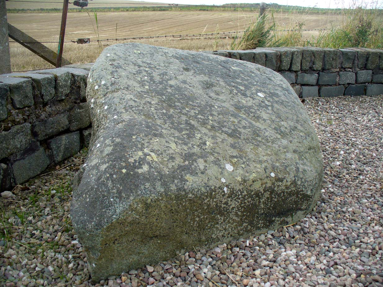
The Girdle Stane
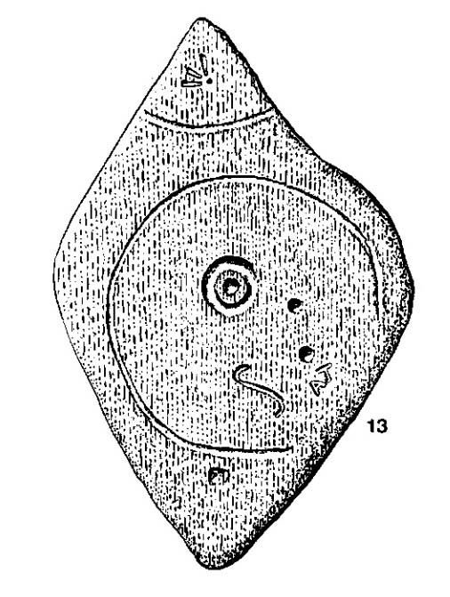
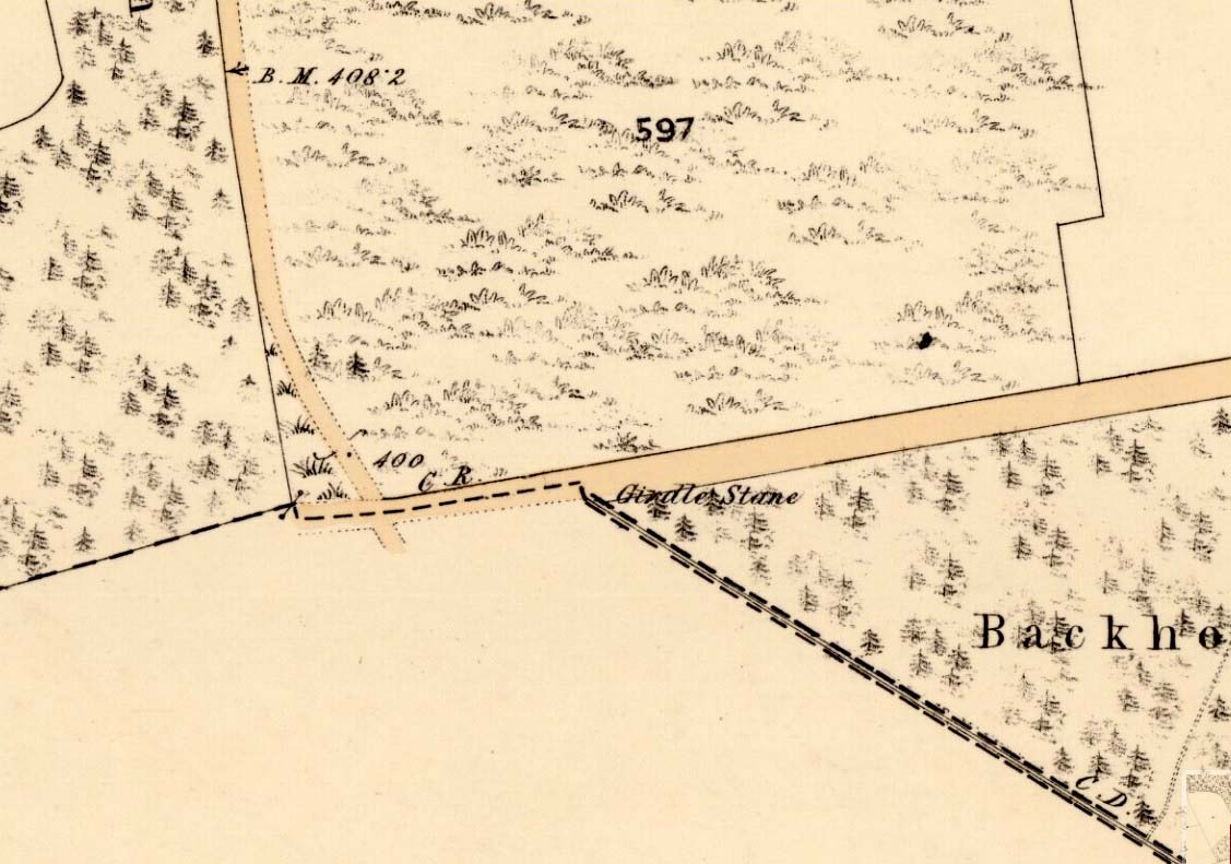
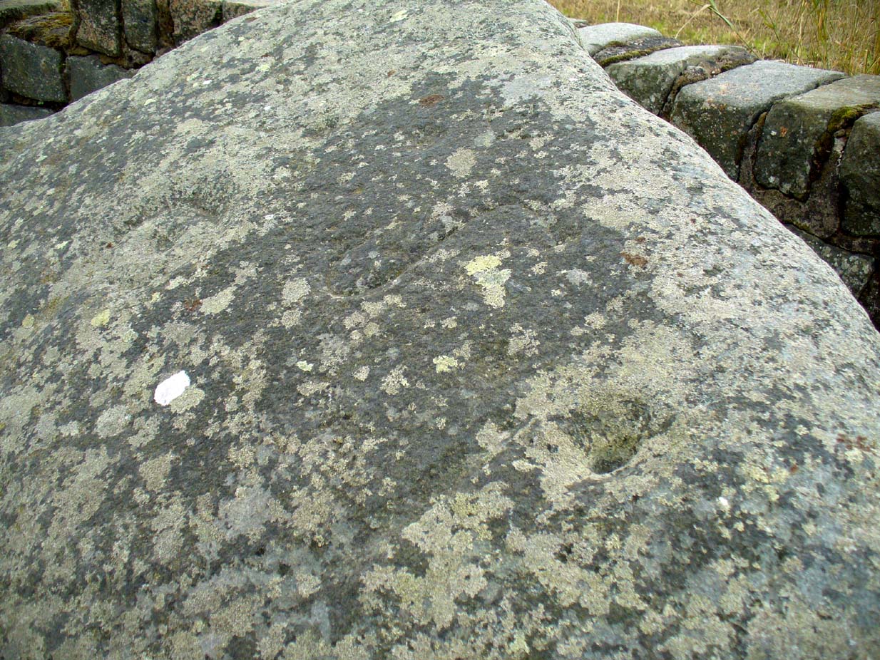
This cup-and-ring stone is not in its original position. Although we know from Ordnance Survey records in the 1860s that it was located about 130 yards north of here, close to the road junction, even that is unlikely to have been its original position—but we know not where that might have been! It is an undoubted multi-period carving, with the earliest section being our typical neolithic or Bronze Age cup-and-ring near the centre of the stone, with several outlying cup-marks toying with our intellect as per usual! The central cup-and-ring may have an incised line running down out of it, although this isn’t highlighted on John Sheriff’s (1995) drawing of the stone.
Girdle Stane on 1865 map
Surrounding the central archetype, by some distance, is a much wider carved ring that almost reaches to defines the edges of the stone itself. This large encircling motif and other features of the petroglyph—including a large elongated “S” and marks that were probably executed by the Ordnance Survey lads at the bottom corner—were ingredients which prompted Sir James Simpson (1867) to question the veracity of the Girdle Stane’s antiquity. He wrote:
“The so-called ‘Girdle-stone’ in the…parish of Rescobie, about four feet long and three broad, is cut on its surface with two circles, the largest of which is above two feet and a half broad, and hence does not, I believe, belong to the class which we are considering in this essay”—
More recent “S”-shaped motif
Close-up of cups, ring and lines
i.e., neolithic or Bronze Age petroglyphs. And you can see his point! My first impression when Prof Paul Hornby and I visited the site a few days ago, after the initial “that’s a cup-and-ring in the middle”, was to proclaim: “that bit’s much more recent, maybe Pictish?” But it probably isn’t even Pictish. This “more recent” carved element is a distinct large elongated “S”, which may have been marked onto it when the stone was used as a township boundary marker between the local parishes. The grand historical writer Alex Warden (1882) talks about this in his magnum opus, saying:
“At the junction of two roads, a little to the northeastward of Letham, there is a rough boulder, about five feet long by three in breadth, having on its face a circle of about thirty inches in diameter, and another smaller circle about six inches across. It is called the Girdle Stane of Dunnichen, from the larger circle resembling the utensil called the girdle, s.c. This stone marks the boundaries between the parishes of Dunnichen and Rescobie, also between the lands of Dunnichen and Ochterlony (Balmadies). It is probably the Grey Stone referred to in a note on the marches of Dunnichen, about 1280.”
Folklore
The folklore of the stone indicates how its origins are rooted in prehistory, despite the later additional symbols. Alex Warden (1882) tells the all-too-familiar creation myth, usually symptomatic of giant prehistoric cairns:
“Tradition says a witch was carrying this boulder from ‘the Crafts’ of Carmylie in her apron, when the strings broke, and the stone fell where it now lies.”
Carmyllie Hill is 5 miles (8km) to the south and is a place rich in fairy-lore and vandalized prehistoric sites.
References:
Coutts, Herbert, Ancient Monuments of Tayside, Dundee Museum 1970.
Kidd, Scott, The Churches of the Parish of Dunnichen, David Winter: Dundee 1995.
Simpson, James, Archaic Sculpturings of Cups, Circles, etc., Upon Stones and Rocks in Scotland, England and other Countries, Edmonston & Douglas: Edinburgh 1867.
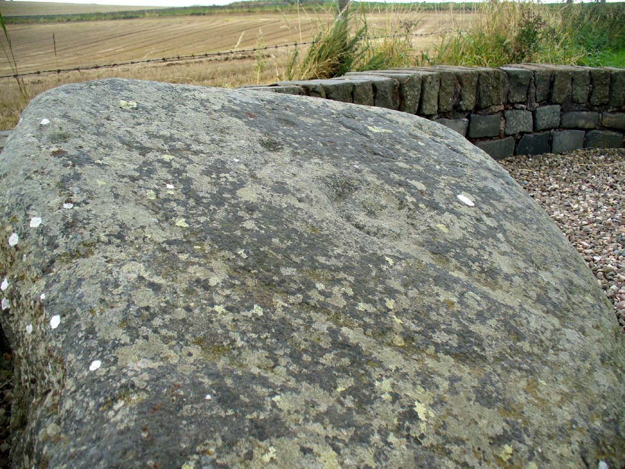
Standing Stone? (destroyed): OS Grid Reference – SE 2428 2329
Archaeology & History
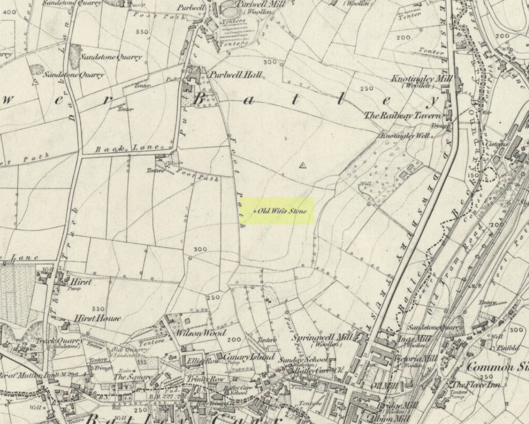
Old Wifes Stone on 1854 map
My first hint at the existence of this once valuable archaeological relic came as a result of me seeking out the history and folklore of some hitherto unknown, forgotten holy wells in the Batley and Dewsbury area. I located the material I was looking for on the old wells, but my fortuitous discovery of this site, the Old Wife’s Stone, blew me away!
It was the place-name of ‘Carlinghow’ about one mile northwest of the grid-reference above that initially caught my attention. From an antiquarian or occultist’s viewpoint, it’s intriguing on two counts: the first is the element ‘how‘ in Carlinghow, which can mean a variety of things, but across the Pennines tends to relate to either an ancient tribal or council meeting place, or a prehistoric burial cairn: an element that wasn’t lost in the giant archaeology survey of West Yorkshire by Faull & Moorhouse (1981). But the first part of this place-name, ‘carling‘, was the exciting element to me; for it means ‘old woman,’ ‘old hag,’ ‘witch’ or cailleach! The cailleach (to those who don’t know) was the prima mater: the Great Mother deity of our pre-christian British ancestors. Meaning that Carlinghow hill was a hugely important sacred site no less—right in the heart of industrial West Yorkshire! What is even more intriguing—or perhaps surprising—is that we have no record of such a powerful mythic creature anywhere in local folklore… Or so it first seemed…
Memory told me that no such prehistoric remains were recorded anywhere in that area—and certainly no prehistoric tombs. I scoured through my library just to triple-check, and found the archaeological records as silent as I first thought. Just to make sure I spent a day at the Central Library, where again I found nothing… So then I explored the region on the modern OS-maps, only to find that much of the area where the Carlinghow place-name existed was, surprisingly, still untouched by housing and similar modern pollutants. This was a great surprise to say the least. And so to check for any potential archaeological sites which might once have been in the Carlinghow area, I turned to the large-scale 1850 OS-maps (6-inch to the mile).
This is when I came across the Old Wife’s Stone, marked in the middle of fields on the outskirts of old Batley. There was no notice of it being a standing stone, or a simple boulder, or archaeological relic—nothing. But its place-name compatriot of ‘Carlinghow’ was the rising hill about a mile to the northwest. In days of olde, if Carlinghow was indeed the ‘burial tomb of the Old Woman’ or ‘meeting place of the cailleach’ (or whatever variants on the theme it may have been), it may have marked the setting sun on the longest day of the year if you had been standing at the Old Wife’s Stone – a midsummer sunset marker no less. (There are other ancient and legendary sites scattering northern England and beyond that are dedicated to the Cailleach, like the Old Woman Stone in Derbyshire, the Old Wife’s Neck in North Yorkshire, the Carlin Stone in Stirlingshire, the Old Woman Stone at Todmorden, Carlin Stone of Loch Elrig and many more.)
As if these curious ingredients weren’t enough to imply something existed in the heathen pantheon of Batley before the Industrialists swept away our indigenous history, we find echoes of the ‘Old Woman’ yet again, immediately east; this time where the animism of water and trees enfolded Her mythos in local rites and traditions, thankfully captured by the pens of several writers, and transmuted into another guise—but undeniably Her! But that, as they say, is for another day and another site profile…
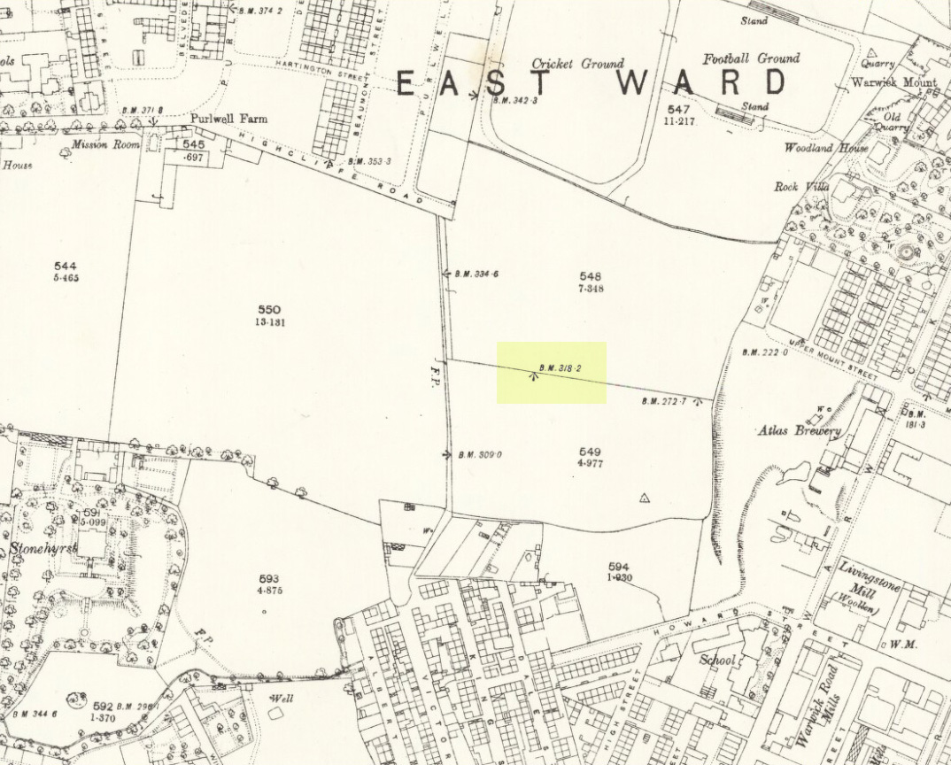
Position of stone in 1894
So is our Old Wife’s Stone (or for that matter, Carlinghow’s old tomb) still in evidence? A school has been built where it was highlighted on the 1854 OS-map and, from the accounts of local people, seems to have long since disappeared. The stone looks to have been incorporated into a length of walling, sometime between 1854 and 1888, and a bench-mark of “BM 318.2” carved onto it. But when the Ordnance Survey lads re-surveyed the area in 1905, this had gone. I have been unable to find any more information about this site and hope that, one day, a fellow antiquarian or occult historian might be able to unravel more of its forgotten mythic history.
References:
Faull, M.L. & Moorhouse, S.A. (eds), West Yorkshire: An Archaeological Survey to 1500 AD – volume 1, WYMCC: Wakefield 1981.
Goodall, Armitage, Place-Names of South-west Yorkshire, Cambridge University Press 1914.
Keighley, J.J., ‘The Prehistoric Period’, in Faull & Moorhouse, 1981.
o’ Crualaoich, Gearoid, The Book of the Cailleach, Cork University Press 2004.
Smith, A.H., English Place-Name Elements – volume 2, Cambridge University Press 1956.
Smith, A.H., The Place-Names of the West Riding of Yorkshire – volume 2, Cambridge University Press 1961.
Wright, Joseph, English Dialect Dictionary – volume 1, Henry Frowde: London 1898.
Acknowledgements: Many thanks for the assistance of Simon Roadnight and Julia King in the Batley History Group.
Sacred Well (destroyed): OS Grid Reference – NO 32898 50521
Also Known as:
Carling Well
Archaeology & History
Carlin Well on the 1865 OS-map
Also known as the Carling Well, this place was shown on the earliest Ordnance Survey maps near the middle of the field next to Carlinwell Farm. On that map (as we see here) the water source had a singular track leading straight from the road to the well and no further. But by 1900 both the track and the well had been covered over and seemingly destroyed. A great pity…for if the place-name and dialect analysis is correct, this was once another sincere site dedicated to the cailleach, or Old Woman, or witch of Gaelic legend: the prima Mater of indigenous Scottish, Irish and northern myth.
The dip in the field where Carlin Well once appeared
The word “carlin/g” is explored in some detail in William Grant’s (1941) magnum opus, giving all possible derivations as found in Scotland. Whilst one definition relates the word to being “the last sheaf of corn in the harvest field”, this element relates to the wider mythic virtues of the cailleach Herself. It’s general form relates specifically to a “woman, generally an old woman and often in a disparaging sense”; aswell as “properly an old crone, but now generally in sense of a big woman.” Again, these are attributes central to the cailleach Herself. The derivation of “a witch” is widely known, and is a term used across the northern lands in stories of pre-christian lore and Creation Myths, specific to the cailleach. One more derivation tells of the word relating to a corruption of Yule plays (possibly relating once again to Nature’s cyclical traditions as enacted by our peasant ancestors which would once more have been attributed to the cailleach) and another saying how the word was used as a derogatory term to insult men!
But unless good evidence to the contrary can be show, this covered site is, in all probability, another example of a place that was dedicated to the primary heathen female deity, or Earth goddess, as She was known throughout the northern lands of England and Scotland.
Carling Well field, looking north
The field in which the well once emerged has a distinct ‘bowl’ shape to it, exactly where the Carlin Well is shown on the map—and this large bowl can be seen clearly from the A926 road above, as shown in the photo here. When we visited the site a week ago, the field was still full of crops so we didn’t explore the site; and we could find no one at the adjacent farm of the same name, who we hoped might have been able to give us further information. If anyone has any further information about the place, please let us know!
References:
Grant, William (ed.), The Scottish National Dictionary – volume 2, SNDA: Edinburgh 1941.
One helluva climb to reach this little fella. I simply started at Dalgirdy cottage, some 5 miles along Glen Lochay, on the right-hand side of the road. Then, walk right up the burnside, all the way up until it begins to level out and the old shielings appear. When you’ve got to where they just about finish, about 50-70 yards on the east side of the burn, you’ll see the small stone standing upright, all alone. You can’t really miss it!
Archaeology & History
Allt Ghaordaidh, looking south-ish!
No previous written records exist that describe this small standing stone, whose nature and age may be akin to that at nearby Tirai, found amidst the derelict village a couple of miles east, lower down the slopes — i.e., it may have simply been part of some of the ancient village remains and shielings found close by, either side of the rushing burn. But whether it’s only medieval or much more ancient than that, its position in the landscape alone (much like Tirai’s uprights), deserves to be known about.
There are considerable amounts of ancient remains scattering the mountains slopes all round here: some have been catalogued, but a lot of it has not. This little standing stone is at last alive again! (take good food and kit when visiting here)
This fascinating looking carving (in my personal Top 10 of all-time favourites cup-and-rings in the UK!) was unfortunately destroyed sometime between 1918 and 1920. A huge pity, as the design on the rock is almost unique in its ‘linear’ system of cups running a considerable length across the surface of the stone (like the similar design found at Old Bewick in Northumberland).
Wilson’s 1851 drawing of the Witches’ StoneSimpson’s 1866 drawing of the Witches Stone
Shown first of all on Kirkwood’s Environs of Edinburgh map in 1817 (above), this legendary rock was found amidst a cluster of other cup-and-ring stones at Tormain (some are still there) and was initially said by Daniel Wilson (1851) to have been the giant capstone of a cromlech that once stood here, but whose structure had fallen away. This idea is implied in the earliest drawing we have of the stone in Wilson’s magnum opus (above); Sir J.Y. Simpson (1867) gave us a similar impression with his drawing a few years later. But upon visiting the Witches Stone just as his book was going to the press, Mr Wilson visited the site and proclaimed that he “altogether doubted if they are the remains of a cromlech”, and what rested here were more probably just fascinating geological remains, with even more fascinating carvings on top!
In the years that followed Wilson’s initial description, the Witches Stone was visited and described by a number of eager antiquarians. Simpson (1867) gave us a quite revealing account, telling:
“On the farm of Bonnington, about a mile beyond the village of Ratho…are the remains of ‘this partially ruined cromlech’…with the capstones partially displaced, as if it had slid backwards upon the oblique plane of the huge stones or stone which still supports it. Two or three large blocks lie in front of the present props. Its site occupies a most commanding view of the valley of the Almond, and of the country and hills beyond. The large capstone is a block of secondary basalt or whinstone, about twelve feet long, ten in breadth and two in thickness. Its upper surface has sculptured along its median line a long row of some twenty-two cup-cuttings; and two more cup-cuttings are placed laterally: one, half a foot to the left of the central row and at its base; the other, two feet to the right of the tenth central cup and near the edge of the block. The largest of the cups are about three inches in diameter and half an inch in depth; but most of them are smaller and shallower than this…”
A few years later another early petroglyph authority, J. Romilly Allen (1882), visited the Witches Stone and found “an Ordnance bench mark (had been) cut on the stone itself”! He then continued with his own description of this once-important megalithic site:
“The Witch’s Stone is a natural boulder of whinstone, rounded and smoothed by glacial action, whoso upper surface slopes at an angle of about 35° with the horizon. The length of the sloping face is 8 feet and at the top is a flat place 2 feet wide. The breadth of the stone is 11 feet 3 inches at the upper end, and 4 feet at the lower end. The thickness varies from 2 to 3 feet. The highest part of the stone is 6 feet 6 inches above the ground, and the lowest 1 foot 6 inches. It rests on what has originally been a portion of the same boulder, but is now a mass of whinstone broken up into several fragments, which serve as supports to prop up the stone above. Viewed from the north side the whole presents the appearance of a cromlech, the upper stone forming the cap, and the disintegrated portion below the supports. This notion, however, will be clearly seen to be erroneous on looking at it from the opposite side, as shown on the accompanying sketch…where the crack separating the two portions of the boulder is very apparent… The sculpturings consist of twenty-four cups varying in diameter from 1½ to 3 inches. Twenty-two of these cups are arranged in an approximately straight line along the sloping face of the stone, and divide it into two almost equal parts. The two remaining cups lie, one 7½ inches to the left of the lowest cup of the central row, and the other 2 feet 3 inches to the right of the ninth cup up the stone… The field in which the Witch’s Stone is situated is called “Knock-about.” The sloping face of the stone has been much polished by the practice of people climbing on to the top and sliding down. Some of the cups are almost obliterated in consequence. The stone forms a very prominent feature in the view, and must always have attracted attention from its peculiar shape.”
Some twenty years after Allen, the megalithomaniac Fred Coles (1903) came and checked the Witches Stone out for himself and, as happens, had a few additional things to say about the place:
“Although this huge boulder and its cup-marks have been more than once figured and described, I found, on a close examination of the broad surface of the Stone, that none of the illustrations showed the cup-marks in their exact relation to each other, nor in their true relation to the contour of the Stone. The drawing shown above…was made after a careful measurement by triangulation of the Stone; and it is claimed to be the first that shows that the cups, two and twenty in number, are not disposed in one continuous line, but that thirteen follow each other from the high south edge of the stone for a distance of exactly 6 feet, and nine others lie a few inches to the west, occupying a space 3 feet long of the overcurving edge of the north end. It is further shown that, at a point 2 feet 3 inches west of the ninth cup-mark, there is another one quite as large as the largest in the rows near the middle of the Stone. The south edge (A B) has slipped a little down from its original height, the boulder being frost-split horizontally; its height there above ground is 8 feet. The northern and narrower end is about 2 feet above ground, and does not touch the ground, as it rests upon its lower portion, beyond which it projects a few inches. The cup-marks run due north.”
Fred Coles 1903 drawing
If the Witches Stone was in fact a natural outcrop stone and not a cromlech, this very last point telling that “the cup-marks run due north” probably had much greater importance than a mere compass-bearing to the people who etched this carving. For in pre-christian religious structures across the northern hemisphere, north is commonly representative of death and the land of the gods. In magickal rites “it is the place of greatest symbolic darkness,” as neither sun nor moon ever rise or set there. Additionally, north is the place where, in shamanic traditions, the heavens are tied to the Earth: the cosmic axis itself that links heaven, Earth and underworld. In early neolithic traditions this mythic structure was probably endemic. Whether its magickal relevance was intended here, at this stone, we will probably never know…
Folklore
Folklore tells that the Witches Stone was one of the sites used in magickal rites by the Scottish occultist, Michael Scot. J.R. Allen’s (1882) description of “the sloping face of the stone has been much polished by the practice of people climbing on to the top and sliding down,” may relate to folk memory of fertility rites once practiced here, as found at similarly carved rocks in the UK and across the world.
McLean, Adam, The Standing Stones of the Lothians, Megalithic Research Publications: Edinburgh no date (c.1978).
Morris, Ronald W.B., The Prehistoric Rock Art of Southern Scotland, BAR: Oxford 1981.
Royal Commission on the Ancient & Historical Monuments of Scotland, Inventory of Monuments and Constructions in the Counties of Midlothian and West Lothian, HMSO: Edinburgh 1929.
Simpson, James, Archaic Sculpturings of Cups, Circles, etc., Upon Stones and Rocks in Scotland, England and other Countries, Edmonston & Douglas: Edinburgh 1867.
Carlie Craig is the tree- covered cliff, centre of photo
If you’re coming from Blairlogie, a half-mile west of the village, take the B998 road to the university, but turn right up the first road that runs uphill into the trees. But if you’re coming from Stirling or Bridge of Allan, keep your eyes peeled for the barely visible B998 at the crossroads and go up the hill, and along, for a good mile, below the Uni, past the factory, then up the small road on your left. Up this road go past the church another 100 yards and you’ll see the derelict ruins of Logie Kirk on your right. Right above the ruin you’ll see the tree-lined cliff immediately behind. This is the Carlie Craig!
Folklore
Carlie Craig on the 1862 map
The tree-covered Carlie Crags above the old ruined church and graveyard of Logie Kirk immediately below (thought to have been built in 1684) has long been associated with legends of old witches. Deriving its name from ‘carlin’, a witch or old woman (cailleach), the Crags were traditionally the place of heathen rites (authentic ones, not your plastic pagan types). In David Morris’ (1935) essay on the local township, he told the common story that “an elder in Logie Kirk was of the opinion that the Carla’ Craig…was haunted.” At the end of the 19th century, Morris remembered a local lady known as ‘Ailie’, who was said by many old folk to be the traditional “witch of Logie.”
“Sickly children were brought to her for her blessing. Occasionally people came from as far as Stirling on this errand. Her method of giving the blessing was to blow her breath on the child, and this was supposed to ward off evil. It was also said that anyone buried in Logie Kirkyard on the first day of May, Hallowe’en, or other days of that kind, without her blessing, would not rest in his grave…”
Another legend told that,
“around 1720 witches were believed to rendezvous with the Evil One (i.e. the devil) who would appear in the form of a large black dog.”
A lengthier account of the belief in witchcraft and animistic pre-christian rites above the crags was told by Charles Rogers (1853):
“About the second decade of last century, there lived in the parish of Logie several ill-favoured old women, to whom the reputation of witchcraft was confidently attached. They were believed to hold nocturnal dialogues and midnight revels with the Evil One, and Carlie Crag was regarded as one of their places of rendezvous. Satan, though he was believed to appear to them in various forms, was understood, in his interviews with the dreaded sisterhood, to appear most frequently in the aspect of a large shaggy dog, in which form it was alleged he had repeatedly been seen by the minister. An elder of the kirk had been returning of an evening from a shooting excursion among the hills, with a trusty musket, which he had picked up some years before on the field of Sheriffmuir, and discovering on the top of Carlie an animal realizing the description of the Satanic mastiff, resolved to try upon it the effects of a shot. He knelt down cautiously near the foot of the crag, and after ejaculating a short prayer, and slipping into his musket a silver coin, fired with trembling heart but steady aim. His victim, evidently shot dead, tumbled to the base, and the delighted and astonished elder lost no time in personally communicating to the minister the success of his wonderful adventure. Though not a little superstitious, the minister was somewhat sceptical as to the mysterious dog being really dead. He however agreed to accompany his elder next morning to the foot of the crag to inspect the carcase; but on reaching the spot, they found the remains of no shaggy dog or evil genius, but the lifeless form of the beautiful pet goat of a poor and aged woman, a much respected parishioner. The minister and elder both shed tears. The wicked dog still lived, the innocent goat had perished. The elder however took credit to himself for his good intentions and valorous intrepidity ; and the minister deemed it proper to improve the subject in his pulpit prelections on the following Sabbath. Discoursing on the subject of resistance to the Devil, he remarked, that the Evil One might assume numerous shapes and forms; that he went about as a roaring lion was declared in the Word, but he might take to himself various other aspects. He might even appear as a black colley dog.” But whatever form he may assume,” added the minister, ” he cannot be overcome or destroyed by powder and shot. There is a gun, however, that will shoot him, and it is this — it is the Bible. Shoot him then, every one of you, with this gun, and he shall be shot.”
Whether the vicar’s biblical superstitions were adopted by local people—who were so much more used to the living animism of landscape and natural cycles—is questionable. The crag is a fine site for ritual magick and its associative devil-lore probably derives from Pictish shamanistic practices, remains of which are evident across the Scottish hillls and northern England, where they survived for some considerable time…
References:
Morris, David, B., “Causewayhead a Hundred Years Ago”, in Transactions of the Stirling Natural History and Archaeological Society, 1935.
Roger, Charles, A Week at Bridge of Allan, Adam & Charles Black: Edinburgh 1853.
Watson, Angus, The Ochils – Placenames, History, Tradition, Perth & Kinross District Libraries 1995.

")


")
")
sm")
")

