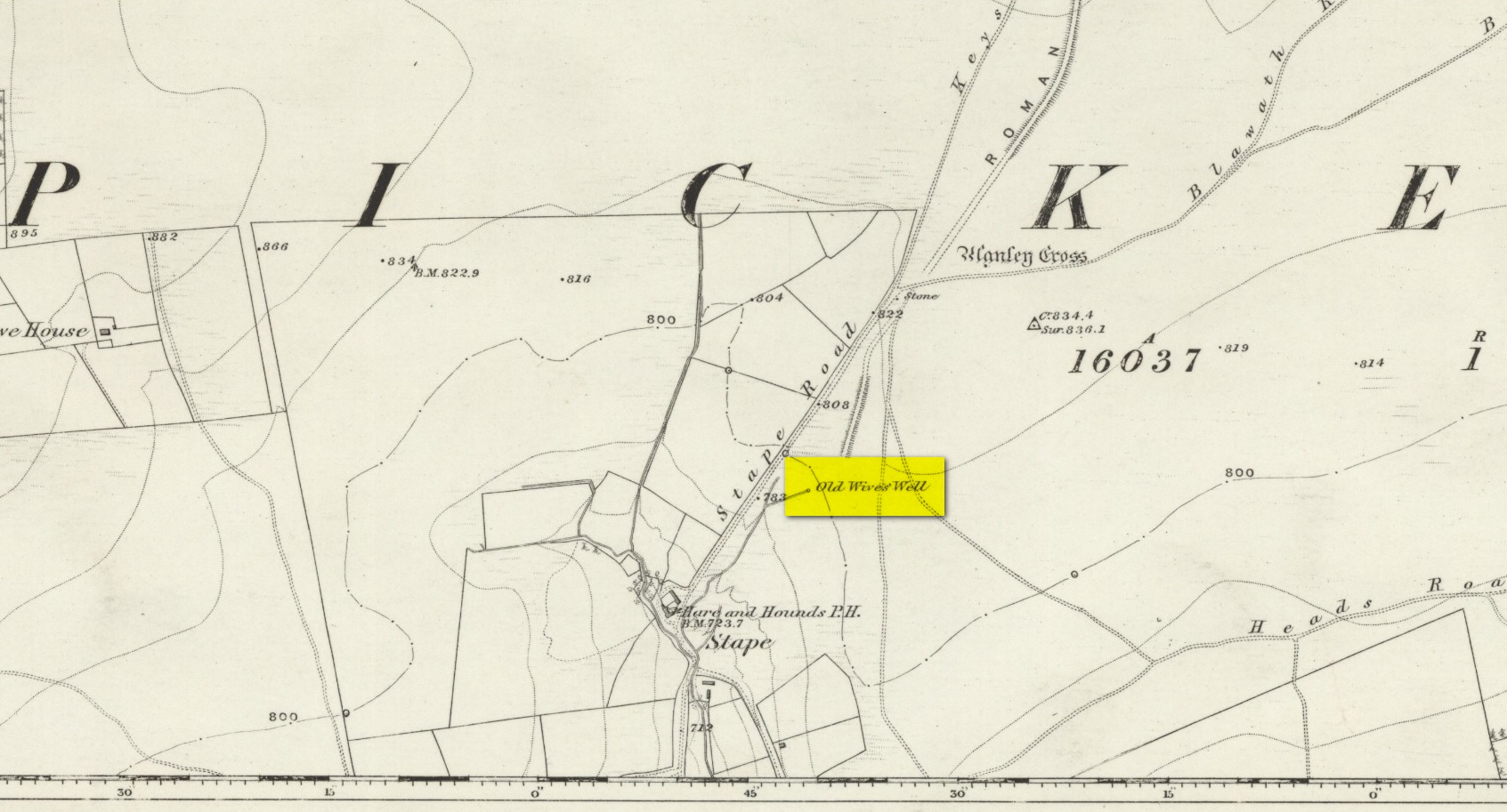
The history of the site is scanty to say the least. It first seems to have been recorded when the Ordnance Survey lads came here in the 1840s, although they left no record as to why the site was given such a dedication. It’s a decidedly pre-christian title as the name “old Wife” is usually indicative in northern counties as being related to the primal Earth deity of northern England and lowland Scotland (when we reach the Highlands and Ireland, She becomes known—amongst other names—as the cailleach). However, apart from its name we have no additional information. Neither the holy wells writer Edna Whelan (1989; 2001), nor hydrolatry researcher Graeme Chappell were been able to find anything about the place in their own researches. And so we must go on name alone…
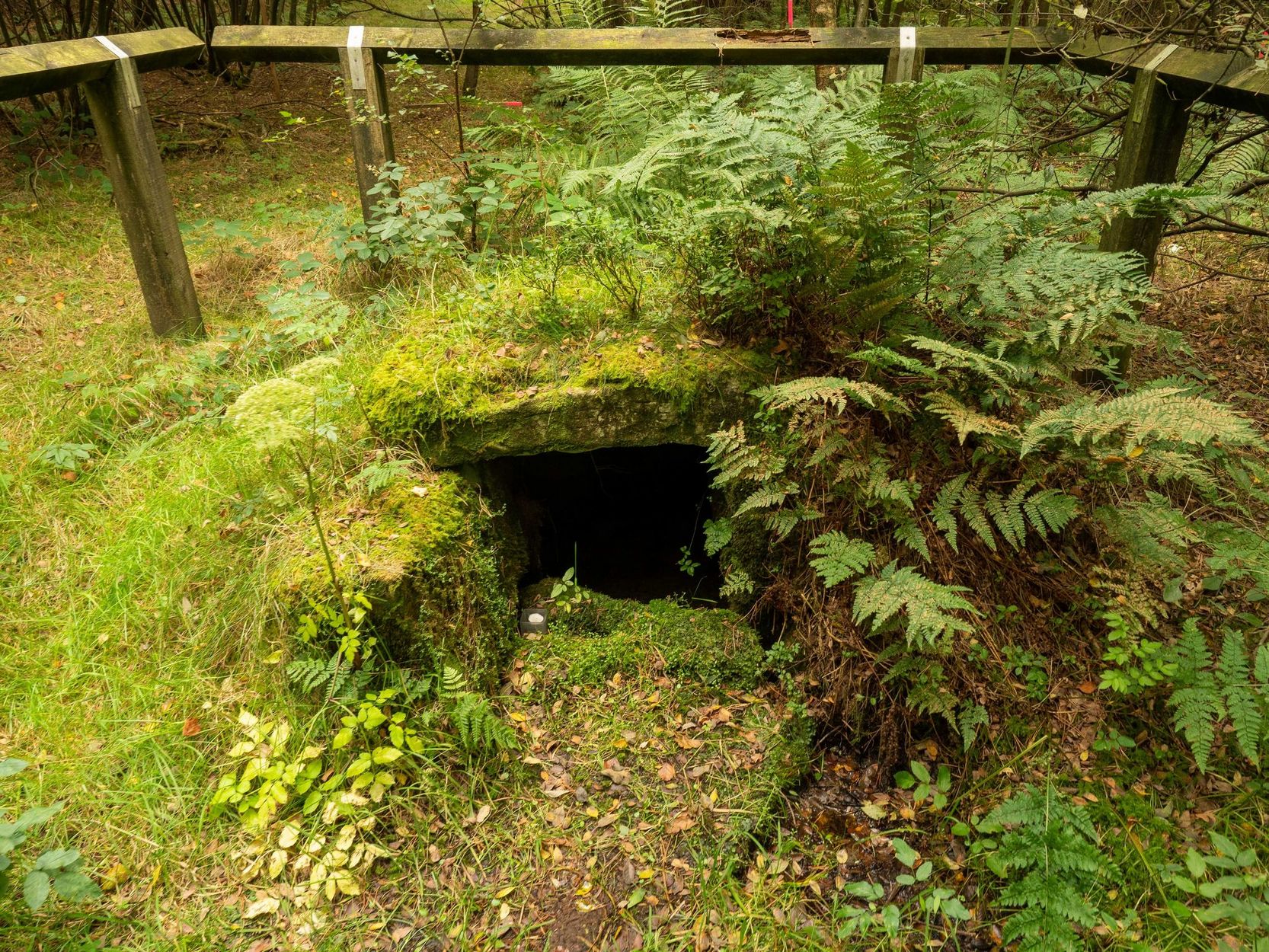
The waters bubble up into a small stone-lined chamber with the words Nattie Fontein carved into the lintel. This is something of a mystery in itself, for, as Edna Whelan (1989) told,
“it would be most unusual for the word fonten to be used for a spring in North Yorkshire: ‘keld’ is the local word. The rather roughly inscribed word may be a corruption of Fons Natalis, the name of a Celtic water nymph.”
Graeme Chappell (2000) meanwhile, noticed in a visit to the site in June 1999,
“that the N and A in “NATTIE” are carved in such a way that the word could be read as “MATTIE FONTEIN” perhaps meaning “Mother Fountain”. This might then be another reference to the Old Wife?”
He then goes on to note how,
“the latin word ‘natalis‘ meaning ‘birth’ and its link with the roman Festival ‘Dies Natalis Sol Invictus‘ (day of the birth of the unconquered sun) which took place on the 25th December. Natalis also gave rise to the welsh word ‘Nadolig‘ – meaning Christmas.”
This Yuletide element has an intriguing relationship with the name of the well; for to the west of Yorkshire’s borders into Cumbria there was annual gathering known as Old Wives’ Saturday that took place on the first Saturday after Christmas, or first Saturday of the New Year in a person’s house or inn, where a feast was had to bring in the New Year; but there is no known written lore of such a tradition here.
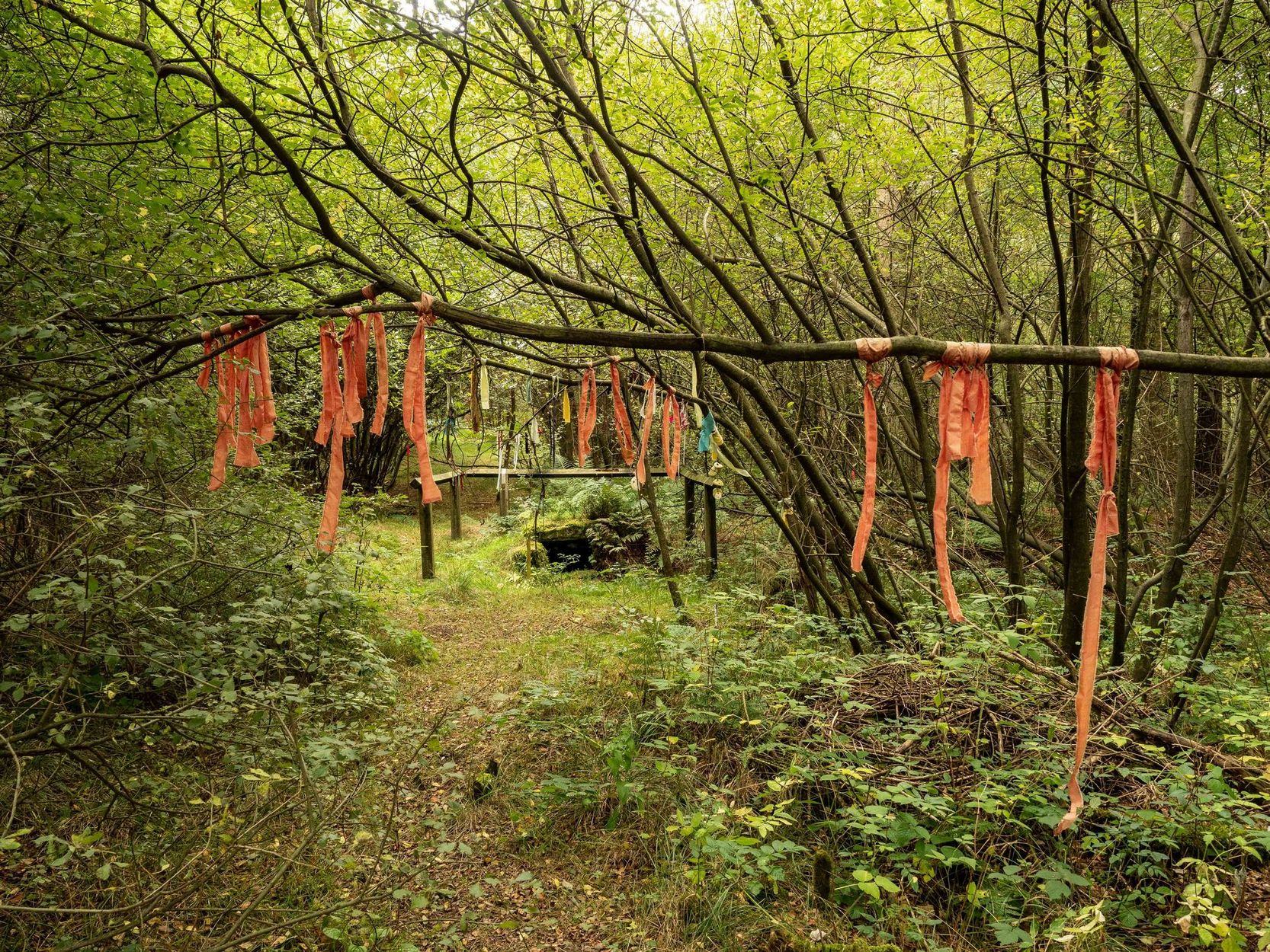
Nowadays the old tradition of hanging rags on the trees surrounding the well as offerings to the spirit of the place (known as memaws in parts of Yorkshire, and clooties in Scotland) has become a regular practice of those who hold such sites as sacred in their own way. Whelan mentioned seeing memaws here in the 1908s, but the Northern Antiquarian contributor Jon Barker told that, “The rags are a comparatively recent addition to the well, it is not a tradition there. When I used to go in the ’60s therewere no rags.”
On an even more curious note: very recently (from when this profile was written), the Northern Antiquarian contributor and photographer James Elkington visited Old Wives’ Well for the first time. It was a grey overcast day and when he arrived here, there was a woman ahead of him at the head of the well. I’ll let him tell the rest of it in his own words:
The Old Wives Well, Stape (James Elkington)Old Wives Well at Stape (James Elkington)
“In front of the well was a lady dressed in what looked like a white nighty, she had her back to me. There was a candle lit nearby, and her hands were in the water moving slowly about like she was washing something. She had long dark shoulder length hair. As I was about 25 feet away I was sure she wasn’t aware of me, and I thought it would make a good photograph. I quietly put my bag on the ground and got my camera out, and looked up and…she was gone! I couldn’t have taken my eye off her for more than 5 or 6 seconds. I looked all around and there was no sign of her. Even if she had legged it through the woods I would have seen her. I think it was then that I realized that I may have had ‘an encounter’. I quickly took three pics of the Well and got the hell out of there!”
He rang me once he had regained his senses in a somewhat emotional state and recounted over and over what had just happened. Whether this was a visual manifestation of the genius loci of the we can’t say. But such encounters are not unknown at numerous sacred water sites all over the world. We can only hazard a guess that this is what he was fortunate to encounter.
Just a few hundred yards north is the old Mauley or Malo Cross, which may or may not have had some mythic relationship with our Old Wives…
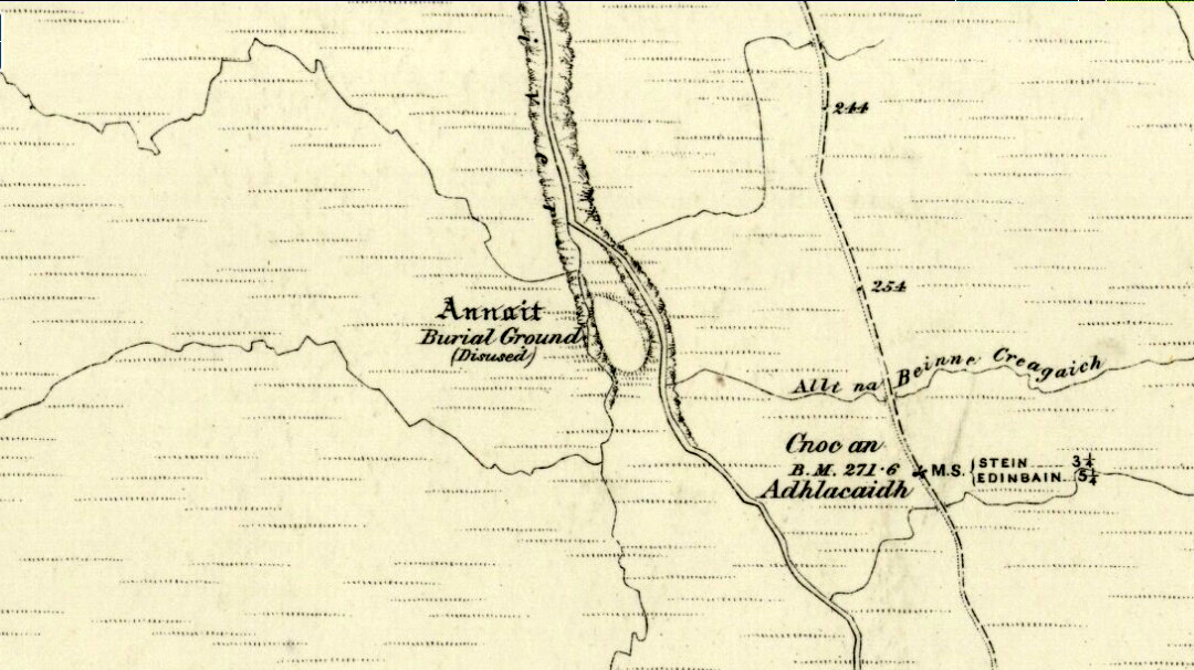
Otta Swire (1961) told how to find this place, thus: “The Waternish road turns off to the north at Fairy Bridge, whence it runs along the valley of the Bay river. On the left of the road, though at some little distance from it, where the river cleaves its way through a gorge to the sea, stands the mound which is now all that remains of the ‘Temple of Anaitis’ (so called).”
Archaeology & History
This is a curious place, full of archaeological potential if the folklore and history records are owt to go by, yet little of any substance remains to substantiate what may have been an important stone circle or other heathen site in earlier times. It seems to have been described first of all in the famous Hebridean journeys of Boswell and Johnson in the late 18th century. Amidst his insulting description of both the landscape and local people, on Friday 17th September 1773, James Boswell visited the site and told:
“The weather this day was rather better than any that we had since we came to Dunvegan. Mr M’Queen had often mentioned a curious piece of antiquity near this which he called a temple of the goddess Anaitis. Having often talked of going to see it, he and I set out after breakfast, attended by his servant, a fellow quite like a savage. I must observe here, that in Skye there seems to be much idleness; for men and boys follow you, as colts follow passengers upon a road. The usual figure of a Sky boy, is a lown with bare legs and feet, a dirty kilt, ragged coat and waistcoat, a bare head, and a stick in his hand, which, I suppose, is partly to help the lazy rogue to walk, partly to serve as a kind of a defensive weapon. We walked what is called two miles, but is probably four, from the castle, till we came to the sacred place. The country around is a black dreary moor on all sides, except to the sea-coast, towards which there is a view through a valley, and the farm of Bay shews some good land. The place itself is green ground, being well drained, by means of a deep glen on each side, in both of which there runs a rivulet with a good quantity of water, forming several cascades, which make a considerable appearance and sound. The first thing we came to was an earthen mound, or dyke, extending from the one precipice to the other. A little farther on, was a strong stone-wall, not high, but very thick, extending in the same manner. On the outside of it were the ruins of two houses, one on each side of the entry or gate to it. The wall is built all along of uncemented stones, but of so large a size as to make a very firm and durable rampart. It has been built all about the consecrated ground, except where the precipice is deep enough to form an enclosure of itself. The sacred spot contains more than two acres. There are within it the ruins of many houses, none of them large, a cairn, and many graves marked by clusters of stones. Mr M’Queen insisted that the ruin of a small building, standing east and west, was actually the temple of the goddess Anaitis, where her statue was kept, and from whence processions were made to wash it in one of the brooks. There is, it must be owned, a hollow road visible for a good way from the entrance; but Mr M’Queen, with the keen eye of an antiquary, traced it much farther than I could perceive it. There is not above a foot and a half in height of the walls now remaining; and the whole extent of the building was never, I imagine, greater than an ordinary Highland house. Mr M’Queen has collected a great deal of learning on the subject of the temple of Anaitis; and I had endeavoured, in my journal, to state such particulars as might give some idea of it, and of the surrounding scenery” —
But in all honesty it seems Mr Johnson was either too lazy to write about the place, or simply didn’t actually get there, in spite of what he alleged! But later that evening, Boswell dined with the same Mr MacQueen, who told him more of this site. In the typically pedantic tone of english supremacy (which still prevails in some idiots who visit these lands), he continued by saying:
“Mr Macqueen had laid stress on the name given to the place by the country people, Ainnit; and added, ” I knew not what to make of this piece of antiquity, till I met with the Anaitidis delubrum in Lydia, mentioned by Pausanias and the elder Pliny.” Dr. Johnson, with his usual acuteness, examined Mr Macqueen as to the meaning of the word Ainnit, in Erse, and it proved to be a water-place, or a place near water, “which,” said Mr. Macqueen, “agrees with all the descriptions of the temples of that goddess, which were situated near rivers, that there might be water to wash the statue.”
There ensued a discussion between Mr MacQueen and Samuel Johnson about the etymology of ‘Anaitis’, with one thinking it was of a goddess, and another that it represented an early christian site. To this day it is difficult to say what the word means with any certainty. In W.J. Watson’s (1993) fine work he tells us,
“Andoit, now annaid, has been already explained as a patron saint’s church, or a church that contains the relics of the founder. This is the meaning in Ireland and it is all we have to go upon. How far it is held with regard to Scotland is hard to say… They are often in places that are now, and must always have been, rather remote and out of the way. It is very rarely indeed that an Annat can be associated with any particular saint, nor have I met any traditions connected with them. But wherever there is an Annat there are traces of an ancient chapel or cemetery, or both; very often, too, the Annat adjoins a fine well or stream…”
The great Skye historian and folklorist Otta Swire (1961) also wrote about this mysterious site, mainly echoing what’s said above, but also adding:
“This name of Annait or Annat is found all over Scotland. It has been interpreted as meaning the ‘Water-place’ from Celtic ‘An’ = water, because many are near water. Others suggest ‘Ann’ = a circle (Celtic) and claim that most Annats are near standing stones. The most-favoured derivation seems to be from Ann, the Irish mother of the Gods, and those who hold this view claim that the Annats are always near a revered spot, where either a mother-church or the cell of a patron saint once stood. Probably Annat does, in fact, come from an older, pre-Celtic tongue, and belongs to an older people whose ancient worship it may well commemorate. The curious shape of the Waternish Temple of Anaitis and its survival make it seem likely that it was something of importance in its day, built with more than usual care and skill. Perhaps the Temple tradition is correct – but whose, if so, and to what gods? One cannot help wondering if cats played any part in its ritual, and if so, if any faint memory remains, for the nickname of the people of this wing was ‘Na Caits’ = The Cats, and not far off, by one of the tributary burns on the right of the roadway, there stands a small cairn, crowned by a long, sharp stone somewhat resembling a huge claw. This is the ‘Cats’ Cairn’.”
The Cats’ Cairn (NG271526) is said to mark the grave of a young boy from the 18th century, who was buried where he died and its story is told elsewhere on TNA. Another example of the Annait place-name can be found elsewhere on Skye at the megalithic site, Clach na h’annait.
References:
Boswell, James, The Journal of a Tour to the Hebrides with Samuel Johnson, National Illustrated Library: London 1899.
Swire, Otta F., Skye: The Island and its Legends, Blackie: Glasgow 1961.
Watson, W.J., The History of the Celtic Place-Names of Scotland, Birlinn: Edinburgh 1993.
From Broadford town, head northwest outta town up the A87 for a mile, turning left and stopping by the electricity station just 100 yards along. Follow the line of cables down, SE, through the trees, dead straight for about 600 yards (crossing the large stream about halfway) till you notice an open gap through the trees on your right where, 40 yards in, there’s a large circular arena which has been kept aside amidst which a scattered mound is clearly visible. In this opening in the trees…this is where the tomb/s rest…
Archaeology & History
Sited a mile east on lowlands beneath the shadow of Beinn na Cailleach mountain, with its host of heathen legends and lore, is reputed to be the prehistoric remains of an important ancestral burial site, under dominion of the cailleach’s eye. In Audrey Henshall’s (1972-2) magnum opus she describes the remains of what may be two separate tombs here as “difficult to interpret”; even “questioning whether they do in fact represent the ruins of a chambered cairn” as has been ascribed. The site is still included in the Canmore survey, where they cite the same reference as I do here, but add no additional data to Henshall’s query. There is obviously something to be seen here, but until excavation of the site has been done, the exact nature of what lies here cannot be clarified. Miss Henshall wrote:
“There is a setting of stones forming about a third of the west side of a circle which would have a diameter of about 30ft if complete; its greatest N to S measurement is 23ft. The stones are thin slabs 4 to 5in thick, up to 3ft 6in long, set on their long sides and projecting up to 2ft above the turf. The stones have probably been reduced in size due to natural fracturing as the stone readily flakes away. Within this setting, which might be interpreted as the kerb of a cairn, there is a rise of about 1ft above ground level and the grass grows greener, but except for this and a number of boulders lying about the site, there is no sign of cairn material. This is curious as there is no obvious reason for removing it.
“Inside the ‘kerb’ there is a horse-shoe setting of five similar slabs, just visible except for two on the S side which project 1ft 2in due to some peat on their N side having been removed. The enclosed area is 7ft wide by 7ft 6in long, open on the E end. On this side, 14ft from the W end of the setting, is a larger stone, set on end, 2ft 8in high. This might be regarded as a portal stone except that it is set opposite the centre of the open end of the horse-shoe setting, and there is a low thin slab projecting westwards from the middle of its W face. E of this there lie a number of flat slabs and boulders, the larger (some measuring 3ft 8in by 3ft and 4 by 2ft) marked on the plan, but they do not suggest the form of the original structure.
“A stone is set radially to the kerb, 15ft 8in to the N. It is on its long edge, 4ft 11in long and 2ft 2in high. Twenty eight feet S of the kerb there is a circular setting of small boulders, 6ft 6in across inside, and part of another concentric setting can be traced 6ft outside these.”
References:
Henshall, Audrey, The Chambered Tombs of Scotland – volume 2, Edinburgh University Press 1972.
As you drive down the A87 road towards Broadford from the Kyle, just before Breakish there’s a small road on the left that runs down to Glen Arroch, where the forest lines the hill. A couple of miles beyond the end of the forest, watch out for the TV mast on the slopes on the right-hand side of the road. Stop here and go up the slopes on the left-side of the road (north), to the peak of Sgurr na Coinnich; and once here you’ll see the high rocky peak of Beinn na Cailleach a half-mile to your northeast.
Folklore
The legend of this sacred mountain was described at some length in Otta Swire’s (1961) excellent work on the Isle of Syke. She wrote:
“”As you drive down the road towards Broadford, three peaks can be seen to the north; the first two are Beinn na Greine (2,000 feet) and Scurr na Coinnich (2,401 feet); the third and most northerly is Beinn na Caillich (2, 396 feet). This last must not be confused with the Beinn na Caillich near Broadford, which is one of the Red Cuchullins although, just to make it more confusing, on the summit of our Beinn na Caillich, as on that of her larger sister, tradition has placed a woman’s grave. This time it is that of a giantess, one of the Fiennes: beneath her body is a large crock filled with gold and jewels, for she was a great lady, no less than Grainnhe herself, wife of Fionn, and at her burial every man of the Fiennes, for love of her and of their leader, cast their rarest jewels into the earthenware crock to do her honour. Her story, as is so usual in Celtic legend, is a sad one. Grainne is the daughter of the King of Morven and is reputed the fairest and truest princess in all Alban, so the Grey Magician, who hates all that is good, carries her off. One day, as Fionn and his men rest after hunting, an old, old woman, wrapped in the red mantle that denoted royal blood, comes to him, tells him of the theft of Grainnhe and begs him to rescue her. He agrees, whereupon she gives him a fir twig and three small pebbles, all highly magic; she then goes out of sight ‘on an eddy of the western wind, growing smaller as she went until she seemed no bigger than a butterfly, a honey bee, a red spider on a thin rope of its web, and a speck of dust in the sun’. Fionn sets out and after many adventures, during which he is assisted by several talking animals, he finds the Grey Magician’s palace and escapes with Grainnhe. Thanks to the old woman’s gifts, forests and mountains rise behind the fugitives, but before they can reach the Red river, to cross which is safety, the Magician overcomes the old woman’s charms. They reach the river bank only to find they cannot cross, and Fionn’s magic is exhausted. But Grainnhe has a jewel, a charm against death; as long as she wears it in her hair no evil can harm her; alternatively it will give her one wish and vanish. She takes it from her hair to wish for a boat and immediately sees, as in a vision, the fate to which she will condemn herself if she gives up her talisman. But Fionn is in peril through his efforts to save her, and already she loves him, so she lays the jewel on the water. A boat at once appears and takes them to safety.
Fionn and Grainnhe are married and live in great happiness until Grainnhe’s son is about to be born. Then come messengers to Fionn to tell him that sea-pirates are attacking his small dark-skinned allies, the Sons of Morna, who have sent to remind him of his pledge to assist them. Fionn longs to remain with Grainnhe but will not break his vow. He and his men spend three days defeating the sea-pirates and when he returns Grainnhe and her baby are gone, carried off by the Grey Magician. Fionn learns from his ‘tooth’ that she has been turned into a hind. He searches for her for many years, but she has been sent to run with the deer in lone Glen Affaric and he never finds her. Twelve years later, when the Fiennes are hunting, their hounds pick up a scent and follow it to a small copse; Bran, who is leading, is the first to enter it, whereupon, to the surprise of all, he turns at bay, teeth bared against the Fiennes and his fellow hounds of the pack and will allow no one but Fionn to pass him. Fionn finds him guarding a wild boy, with long hair and wild, beautiful, frightened eyes, who can make only such sounds as deer make. Fionn adopts him and teaches him human speech. Needless to say, he is Grainnhe’s son, but Grainnhe, the beautiful white hind of whom her son talks, is never found. After her death the Grey Magician permits her son to take her body, once more that of a woman, for burial, and the Fiennes make her grave on the summit of Beinn na Caillich, where she once ran as a hind.
It is recounted of this boy that he had in the centre of his forehead a tuft of deer’s fur where his mother’s tongue had licked him, and that it was from her that he got his gift of poetry. Once he was shipwrecked on Fladda and a party of hunters on the island offered him a share of their venison stew, to whom he made indignant reply: ‘When everyone picks his mother’s shank-bone, I will pick my mother’s slender shank-bone.’ The boy was Ossian.”
References:
Bernbaum, Edwin, Sacred Mountains of the World, Sierra Club: San Francisco 1990.
Swire, Otta F., Skye: The Island and its Legends, Blackie & Sons: Glasgow 1961.
Follow the same directions to find the Blackheath Circle, but instead of turning onto the golf course, keep going up the steep road until you reach the T-junction at the top; then turn left and go along the road for about 200 yards, past the second track on the left, keeping your eyes peeled across the small moorland to your left where you can see the rocks rising up. Walk along the footpath towards them. You can’t really miss the place!
Archaeology & History
The Bride at sunset – the fallen Groom to her left
If you’re a heathen or geologist and you aint seen this place, check it out – you won’t be disappointed! First mentioned in 1491, this has always been a place of some repute. Its legendary companion, the ‘Groom’, lays resting on the Earth after being felled sometime in the 17th century.
F.A. Leyland’s 1860s drawing
A beautiful, remarkable and powerful site of obvious veneration. First described in local deeds as early as 1491, there are a great number of severely weathered boulders all round here, many like frozen rock giants haunting a magickal landscape. The modern lore ascribes the stones to be dedicated to Bride, goddess of the Brigantian people. And like Her legendary triple-aspect, we find here in the landscape a triple aspect to the outcrops themselves: to the west are the Bride Stones; to the east, the Little Bride Stones; with the Great Bride Stones as the central group, surveying everything around here.
At the main complex is what is singularly known as the Bride itself: a great smooth upright pillar of stone fourteen feet tall and nine feet wide at the top, yet only about two feet wide near its base, seemingly defying natural law. Watson (1775) described, next to the Bride herself, “stood another large stone, called the Groom…(which) has been thrown down by the country people” – probably under order of the Church. Crossland (1902) told how the Bride also acquired the title, “T’ Bottle Neck,” because of the stone’s simulacrum of an upturned bottle.
The Bride & her Groom (laid on the earth)The ‘head’ or top of the Bride Stone
Scattered across the tops of the many rocks hereby are many “druid basins” as Harland and Wilkinson (1882) described them. Many of these are simply basins eroded over the millenia by the natural elements of wind and rain. It is possible that some of these basins were carved out by human hands, but it’s nigh on impossible to say for sure those that were and those that were not. If we could find a ring around at least one of them, it would help — but in all our searches all round here, we’ve yet to locate one complete cup-and-ring. So we must remain sceptical.
On the mundane etymological side of things, the excellent tract by F.A. Leyland (c.1867) suggested the Bride Stones actually had nothing to do with any goddess or heathenism, but derived simply from,
“the Anglo-Saxon adjective Βñáð, signifying broad, large, vast — hence the name of the three groups known as the Bride Stones. The name of The Groom, conferred on the prostrate remains, appears to have been suggested by the fanciful definition of the Saxon Brád, as given by (Watson).”
However, the modern place-name authority A.H. Smith (1963:3:174) says very simply that the name derives from “bryd, a bride.”
A “rude stone” was described in one tract as being a short distance below this great rock outcrop; it was turned into a cross by the local christian fanatics and moved a few hundred yards west, to a site that is now shown on modern OS-maps as the Mount Cross.
Folklore
Although local history records are silent over the ritual nature of these outcrops, tradition and folklore cited by the antiquarian Reverend John Watson (1775) tell them as a place of pagan worship. People were said to have married here, although whether such lore evolved from a misrepresentation of the title, Bride, is unsure. In the present day though there have been a number of people who have married here in recent years.
If the Brigantian goddess was venerated here, the date of the most active festivities would have been February 1-2, or Old Wives Feast day as it was known in the north. The modern witches Janet and Stewart Farrar, who wrote extensively about this deity (1987), said of Bride: “one is really speaking of the primordial Celtic Great Mother Herself,” i.e., the Earth Mother.
Telling of further lore, Watson said that weddings performed here in ages past stuck to an age-old tradition:
“during the ceremony, the groom stood by one of these pillars, and the bride by the other, the priests having their stations by the adjoining stones, the largest perhaps being appropriated to the arch-druid.”
New Age author Monica Sjoo felt the place “to have a special and uncanny power.” This almost understates the place: it is truly primal and possesses the virtues of strength, energy, birth and solace.
References:
Bennett, Paul, The Old Stones of Elmet, Capall Bann: Milverton 2001.
Crossland, Charles, “Place-Names in the Parish of Halifax in Relation to Surrounding Natural Features,” in Halifax Naturalist, volume 7, 1902.
Farrar, Janet & Stewart, The Witches’ Goddess, Hale: London 1987.
Harland, John & Wilkinson, T.T., Lancashire Folklore, John Heywood: Manchester 1882.
Leyland, F.A., The History and Antiquities of the Parish of Halifax, by the Reverend John Watson, M.A., R.Leyland: Halifax n.d. (c.1867).
Smith, A.H., The Place-Names of the West Riding of Yorkshire – volume 3, Cambridge University Press 1963.
Watson, John, The History and Antiquities of the Parish of Halifax, T. Lowndes: London 1775.
Otta Swire (1961) told how to find this place, thus: “The Waternish road turns off to the north at Fairy Bridge, whence it runs along the valley of the Bay river. On the left of the road, though at some little distance from it, where the river cleaves its way through a gorge to the sea, stands the mound which is now all that remains of the ‘Temple of Anaitis’ (so called).”
Archaeology & History
This is a curious place, full of archaeological potential if the folklore and history records are owt to go by, yet little of any substance remains to substantiate what may have been an important stone circle or other heathen site in earlier times. It seems to have been described first of all in the famous Hebridean journeys of Boswell and Johnson in the late 18th century. Amidst his insulting description of both the landscape and local people, on Friday 17th September 1773, James Boswell visited the site and told:
“The weather this day was rather better than any that we had since we came to Dunvegan. Mr M’Queen had often mentioned a curious piece of antiquity near this which he called a temple of the goddess Anaitis. Having often talked of going to see it, he and I set out after breakfast, attended by his servant, a fellow quite like a savage. I must observe here, that in Skye there seems to be much idleness; for men and boys follow you, as colts follow passengers upon a road. The usual figure of a Sky boy, is a lown with bare legs and feet, a dirty kilt, ragged coat and waistcoat, a bare head, and a stick in his hand, which, I suppose, is partly to help the lazy rogue to walk, partly to serve as a kind of a defensive weapon. We walked what is called two miles, but is probably four, from the castle, till we came to the sacred place. The country around is a black dreary moor on all sides, except to the sea-coast, towards which there is a view through a valley, and the farm of Bay shews some good land. The place itself is green ground, being well drained, by means of a deep glen on each side, in both of which there runs a rivulet with a good quantity of water, forming several cascades, which make a considerable appearance and sound. The first thing we came to was an earthen mound, or dyke, extending from the one precipice to the other. A little farther on, was a strong stone-wall, not high, but very thick, extending in the same manner. On the outside of it were the ruins of two houses, one on each side of the entry or gate to it. The wall is built all along of uncemented stones, but of so large a size as to make a very firm and durable rampart. It has been built all about the consecrated ground, except where the precipice is deep enough to form an enclosure of itself. The sacred spot contains more than two acres. There are within it the ruins of many houses, none of them large, a cairn, and many graves marked by clusters of stones. Mr M’Queen insisted that the ruin of a small building, standing east and west, was actually the temple of the goddess Anaitis, where her statue was kept, and from whence processions were made to wash it in one of the brooks. There is, it must be owned, a hollow road visible for a good way from the entrance; but Mr M’Queen, with the keen eye of an antiquary, traced it much farther than I could perceive it. There is not above a foot and a half in height of the walls now remaining; and the whole extent of the building was never, I imagine, greater than an ordinary Highland house. Mr M’Queen has collected a great deal of learning on the subject of the temple of Anaitis; and I had endeavoured, in my journal, to state such particulars as might give some idea of it, and of the surrounding scenery” —
But in all honesty it seems Mr Johnson was either too lazy to write about the place, or simply didn’t actually get there, in spite of what he alleged! But later that evening, Boswell dined with the same Mr MacQueen, who told him more of this site. In the typically pedantic tone of english supremacy (which still prevails in some idiots who visit these lands), he continued by saying:
“Mr Macqueen had laid stress on the name given to the place by the country people, Ainnit; and added, ” I knew not what to make of this piece of antiquity, till I met with the Anaitidis delubrum in Lydia, mentioned by Pausanias and the elder Pliny.” Dr. Johnson, with his usual acuteness, examined Mr Macqueen as to the meaning of the word Ainnit, in Erse, and it proved to be a water-place, or a place near water, “which,” said Mr. Macqueen, “agrees with all the descriptions of the temples of that goddess, which were situated near rivers, that there might be water to wash the statue.”
There ensued a discussion between Mr MacQueen and Samuel Johnson about the etymology of Anaitis, with one thinking it was of a goddess, and another that it represented an early christian site. To this day it is difficult to say what the word means with any certainty. In W.J. Watson’s (1993) fine work he tells us,
“Andoit, now annaid, has been already explained as a patron saint’s church, or a church that contains the relics of the founder. This is the meaning in Ireland and it is all we have to go upon. How far it is held with regard to Scotland is hard to say… They are often in places that are now, and must always have been, rather remote and out of the way. It is very rarely indeed that an Annat can be associated with any particular saint, nor have I met any traditions connected with them. But wherever there is an Annat there are traces of an ancient chapel or cemetery, or both; very often, too, the Annat adjoins a fine well or stream…”
The great Skye historian and folklorist Otta Swire (1961) also wrote about this mysterious site, mainly echoing what’s said above, but also adding:
“This name of Annait or Annat is found all over Scotland. It has been interpreted as meaning the ‘Water-place’ from Celtic ‘An’ = water, because many are near water. Others suggest ‘Ann’ = a circle (Celtic) and claim that most Annats are near standing stones. The most-favoured derivation seems to be from Ann, the Irish mother of the Gods, and those who hold this view claim that the Annats are always near a revered spot, where either a mother-church or the cell of a patron saint once stood. Probably Annat does, in fact, come from an older, pre-Celtic tongue, and belongs to an older people whose ancient worship it may well commemorate. The curious shape of the Waternish Temple of Anaitis and its survival make it seem likely that it was something of importance in its day, built with more than usual care and skill. Perhaps the Temple tradition is correct – but whose, if so, and to what gods? One cannot help wondering if cats played any part in its ritual, and if so, if any faint memory remains, for the nickname of the people of this wing was ‘Na Caits’ = The Cats, and not far off, by one of the tributary burns on the right of the roadway, there stands a small cairn, crowned by a long, sharp stone somewhat resembling a huge claw. This is the ‘Cats’ Cairn’.”
The Cats’ Cairn (NG271526) is said to mark the grave of a young boy from the 18th century, who was buried where he died and its story is told elsewhere on TNA. Another example of the Annait place-name can be found elsewhere on Skye at the megalithic site, Clach na h’annait.
References:
Boswell, James, The Journal of a Tour to the Hebrides with Samuel Johnson, National Illustrated Library: London 1899.
Swire, Otta F., Skye: The Island and its Legends, Blackie: Glasgow 1961.
Watson, W.J., The History of the Celtic Place-Names of Scotland, Birlinn: Edinburgh 1993.
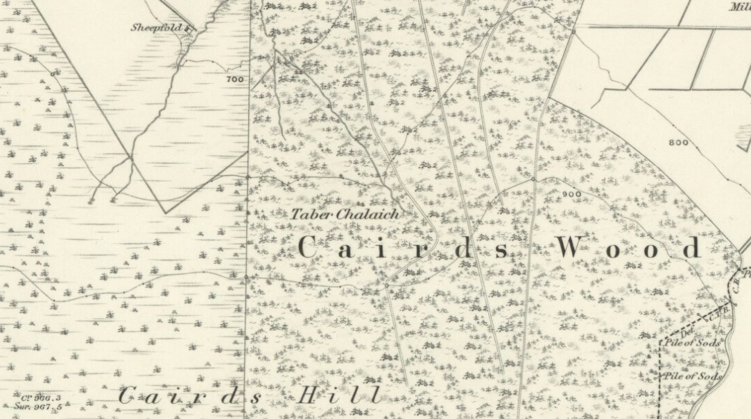
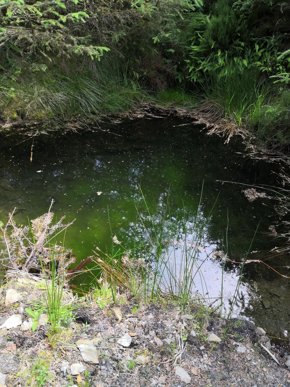
Described on the earliest OS-map of the region as Taber Chalaich, this great “well of the old woman, witch, or hag” is found on the northern slopes of Cairds Hill, amidst increasingly dense woodland up the top of the stream which ebbs and flows in strength (depending on the weather). A water source dedicated to the prima mater Herself — i.e., the heathen pre-Celtic female creation deity par excellence — it was once of considerable repute locally and was known to cure various ailments. It was described by Ruth and Frank Morris (1981) as being,
“the scene of a pagan ceremony in which the Earth Mother in her old woman phase bathed at the well and returned as a young maiden.”
Tobar na Cailleach (21st Century Pict)
This tells us that rites were enacted here around Imbolc (February 1-2). The well can still be found running. A visit to the site in July 2025 by Pol Anndrais found that “the East Side of the pool has been dug out and the rocks used to dam the outlet. The pool is roughly square, about 2 metres across. The inlet is over natural rock visible beneath the surface, the pool is about 1 metres deep and reasonably clear with pond skaters and diving bettles, (but) no visible offerings…”
On the hill at the top we find remains of old tombs (mistakenly ascribed by Mr & Mrs Morris as ‘stone circles’), some of which may have had some mythic relationship with this legendary water source. If anyone has any further information about the folklore or history of this site, we’d love to know about it.
Takes a bit of finding this – but if you like your rock art, it’s worth the search! You can follow directions for the getting to the Man Stone then, when you reach it, look to the near horizon to the east. Get to the bottom of the sloping hillside where a large rounded boulder sits and walk up the slope about 10 yards. Look around here cos you’re very close.
Woman Stone carvingCarving highlighted in chalk
Alternatively, from the Askwith Moor Road, follow the path to the triangulation pillar on Shooting House Hill. Keep going for another 100 yards and check a small path to your left (south). Follow this down until you get to the top of the slope. Go to the bottom of the slope and look around!
This carving is best checked out in winter and early spring: if you go here in summer & autumn there’s bracken covering the entire site & you’ll never find it!
Archaeology & History
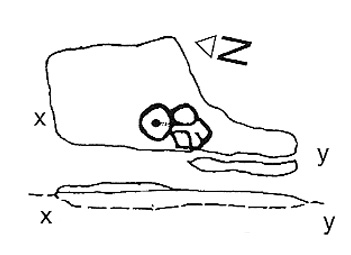
Drawing by Inmaculada Ibanez-Sanchez
This stone was first discovered by Graeme Chappell and I during one of our many ambling explorations here in the early 1990s and was first mentioned in my Old Stones of Elmet (pp.149-152). Marija Gimbutas would have loved this seemingly matriarchal-looking cup-and-ring carving, suggestive of many Mother Goddess images she found across Europe – hence its title!
Woman Stone design (after Boughey & Vickerman)
I don’t think that the old-school archaeological types would lower themselves to say such a thing, but as I aint one of them I’m quite confident in saying that this carving does seem to be a pictorial representation of a female figure: one of the earliest of its kind in the British Isles? (check its nearby male compatriot, the Man Stone – a distinctly human figure and one of the earliest of its kind in the British Isles) Very close by we are left with old place-name remnants pointing directly at the presence of pre-christian goddess remains in the mythic landscape – an issue I’ll expand on in the near future.
In the survey by more recent rock art students Boughey & Vickerman (2003), their illustration of the carving makes it look even more like an early female figure! (though I hear they don’t like people giving the carvings names – unless, of course, one of them lot names it…)
References:
Bennett, Paul, The Old Stones of Elmet, Capall Bann: Milverton 2001.
Boughey, Keith & Vickerman, E.A., Prehistoric Rock Art of the West Riding, WYAS: Wakefield 2003.
Gimbutas, Marija, The Language of the Goddess, Harper-Collins: San Francisco 1989.
Gimbutas, Marija, The Civilization of the Goddess: The World of Old Europe, Harper-Collins: San Franciscoo 1991.