St. Helen’s Well, Maybole, Ayrshire

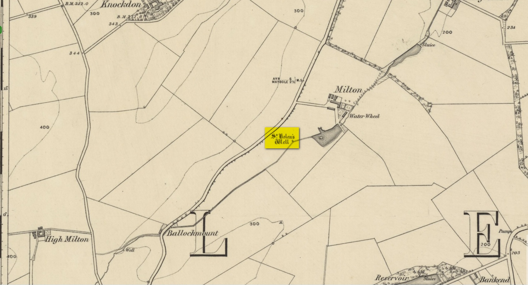
Holy Well (covered):  OS Grid Reference – NS 31322 13423

Archaeology & History

Site on the 1860 OS-map

In spite of this site being covered over some time in the 1950s, it is still retained on the modern Ordnance Survey maps.  It was shown on the first one in 1860, but its literary history goes back much further.  We find it described by the Minister for Maybole — one William Abercrummie — in his short 17th Century work named A Description of Carrict.  He noted several springs in Maybole township, with this one of possessing the usual hallmarks of both christian and peasant customs alike:

“Another spring there is called St. Helens well or by a curt pronuntiation St. Emus for St. Antonies well, it is about a myle and ane halfe from Mayboll on the road to Aire a litle north of Balachmont.  It is famous for the cure of unthriving children, to which at the change of the quarter especially at May-day there is a great resort of people from all quarters, and at a good distance.”

This piece was repeated in several 19th century works, including one by William Roberston (1891), who commented on the traditions themselves, saying:

“This can unquestionably be traced as a remnant of the ancient superstition that miracles were wrought at Holy Wells; which all the anathemas of the Reformed Kirk could not for a time obliterate from the minds of the common people.  The records of the Kirk-session bear witness to the prevalence of applying to Saints’ Wells for the cure of bodily infirmities on stated occasions; particularly, when the Saint or Angel was understood to ‘move the waters.’  Pins, pieces of the dress of the patient, or such small trifles, were left at the well – the remains, no doubt, of the offerings formerly made to the Clergy – and in token that the disease was transferred from the sufferer to the rags, thus offered to the Genius loci.  Numerous traces of this prevailing superstition could easily be cited.”

When the Ordnance Survey dudes wrote about the site in the Name Book in 1857, all they could tell us was that it was, “a beautiful spring of excellent water” but was said to have “no medicinal properties.”

Despite this sacred well now being covered over, there is surely a case to be made here for it to be restored back to its former glory, for all to visit and see.  Local historians, pagans and Christians alike — join forces and gerrit sorted!

References:

  1. MacKinlay, James M., Folklore of Scottish Lochs and Springs, William Hodge: Glasgow 1893.
  2. Mitchell, Arthur (ed.), Geographical Collections Relating to Scotland Made by Walter Macfarlane – volume 2, T. & A. Constable: Edinburgh 1906.
  3. Robertson, William, Historic Ayrshire; Being a Collection of Historical Works Treating of the County of Ayr, Thomson Brothers: Edinburgh 1891.
  4. Walker, J. Russel, “‘Holy Wells’ in Scotland,” in Proceedings of the Society of Antiquaries of Scotland, vol.17 (New Series, volume 5), 1883.

Acknowledgements:  The map accompanying this site profile is Reproduced with the kind permission of the National Library of Scotland

© Paul BennettThe Northern Antiquarian

Coilsfield, Tarbolton, Ayrshire

Cup-and-Ring Stone (lost):  OS Grid Reference – NS 4469 2624

Also Known as:

  1. Canmore ID 42713
  2. King Coil’s Grave Stone
  3. Old King Cole’s Stone (Morris 1981)

Archaeology & History

Daniel Wilson's 1851 sketch of the carving

Daniel Wilson’s 1851 sketch of the carving

This fascinating and very ornate prehistoric carving was found on the underside of a grave-slab beneath Old King Coil’s Grave, or an adjacent prehistoric burial feature (we don’t know for sure).  In Daniel Wilson’s (1851) superb early work on prehistoric Scotland is a detailed drawing of this ornate petroglyph—similar in design and form to those found across the waters in Ireland—copied “from a drawing presented to the Royal Society of Edinburgh by Colonel Hugh Montgomery of Shielmorly, in 1785.”  Mr Wilson informed us that,

“It formed the cover of a cist, discovered in digging a gravel-pit at Coilsfield, in Ayrshire, and underneath it was found an urn filled with incinerated bones. The dimensions of the stone were about five feet in length by two and a half feet in breadth”

James Simpson's 1866 sketch

James Simpson’s 1866 sketch

A few years later Sir James Simpson (1866; 1867) wrote and published the earliest (and still one of the finest) books on aboriginal rock carvings in the British Isles, and all but echoed what Wilson had described.  He added a further description of the designs that were carved onto the stone, telling us that,

“it had cut upon it a series of concentric circles, consisting of six rings placed around a central cup, the rings traversed by a straight radial groove.  On the drawing are marks of other cups and rings, or rather volutes, and a number of angular lines… This sculptured stone covered an urn…”

Following the descriptions of our early authors, many archaeologists and antiquarians explored the site but could find little else about the carving.  In Ron Morris’ (1981) most recent survey, he told us that it was,

“a gritstone slab, 1½m by ¾m (5ft x 2½ft), possibly broken after carving, had on one side (not now known if this was the inner of outer face); a cup-and-six-complete-rings with radial groove from the cup – diameter 50cm (20in) – 5 other cups-and-rings, mostly partly broken off or incomplete, an irregular ‘reversed-S-shaped’ single spiral with 3 convolutions at each end, other irregular grooved figures, 4 cups and about 7 ‘dots’ (6 of these are in the cup-and-six-rings).”

The Royal Commission at Canmore tell us that “the present location of the food vessel and cist cover is unknown”; yet the rock art researcher Ronald W.B. Morris (1981) reported the petroglyph was “said to have been given to the Society of Antiquaries of Scotland but (is) now missing”; whilst the local writer E.H. Letham (1900) told us “the urns were conveyed to Eglintoun Castle.”  This aint good.  Has anyone subsequently found out what became of it?

Folklore

The tumulus of King Coil’s Grave was the legendary resting place of the “Old King Cole” of popular rhymes.  There were two such northern kings in ancient times and, as William Robertson (1889) said, “the only difficulty is to say which of the King Coils he was, whether the Coilu who lived three hundred and thirty years before Christ; or Coel, King of the Roman districts, who must have lived in the third century.”

References:

  1. Letham, E.H., Burns and Tarbolton, D.Brown: Kilmarnock 1900.
  2. Morris, Ronald W.B., The Prehistoric Rock Art of Southern Scotland, BAR: Oxford 1981.
  3. Morris, Ronald W.B. & Bailey, Douglas C., “The Cup-and-Ring Marks and Similar Sculptures of Southwestern Scotland: A Survey,” in Proceedings of the Society of Antiquaries, Scotland, volume 98, 1966.
  4. Morrison, Alex, The Bronze Age in Ayrshire, Ayrshire Natural History & Archaeology Society 1978.
  5. Robertson, William, Historical Tales and Legends of Ayrshire, Thomas D. Morrison: Glasgow 1889.
  6. Paterson, James, History of the County of Ayr – volume 2, Thomas Stevenson: Edinburgh 1852.
  7. Simpson, J.Y., “On Ancient Sculpturings of Cups and Concentric Rings,” in Proceedings of the Society of Antiquaries, Scotland, volume 6, 1866.
  8. Simpson, James, Archaic Sculpturings of Cups, Circles, etc., Upon Stones and Rocks in Scotland, England and other Countries, Edmonston & Douglas: Edinburgh 1867.
  9. Smith, John, Prehistoric Man in Ayrshire, Elliot Stock: London 1895.
  10. Wilson, Daniel, The Archaeology and Prehistoric Annals of Scotland, Sutherland & Knox: Edinburgh 1851.
  11. Young, Alison, “Cup-and-Ring Markings on Creag Ruenshin, with Some Comparative Notes,” in Proceedings of the Society of Antiquaries, Scotland, volume 72, 1937.

© Paul BennettThe Northern Antiquarian 


Witch’s Stane, Craigie, Ayrshire

Legendary Rock (destroyed):  OS Grid Reference – NS 4268 3231

Also Known as:

  1. Canmore ID 42851
  2. White Stane
  3. Witches’ Stone

Archaeology & History

It is difficult to assess the precise nature of this megalithic site, sadly destroyed some two hundred years ago.  The Royal Commission thinks it may have been a rocking stone, but the legend said of it indicates it to have been associated with a giant prehistoric cairn, although nothing remains nowadays.  The site was mentioned briefly in James Patterson’s (1863) huge work on the townships of Ayrshire, where he described the site as “standing upright” and “being in a field on Lodgehouse Farm,” near the village church.

“It stood on three stones, so high that a man could crawl under. It was blasted in 1819 to build houses.  The farmer’s wife, it is said, took some antipathy to it, and would not give her husband rest until he consented to have it removed.  A person of the name of Jamieson, and an assistant, were employed to blast it, which was accordingly done.  When broken up, it filled twenty-four carts.  Such was the feeling of sacrilege occasioned by the removal of the stone, that it was observed the farmer’s wife became blind, and continued so for eight years, when she died. Jamieson, who blasted it, never did well afterwards.  He drank and went to ruin.”

Serves them right!  Additional lore gained from a local lady in the 1870s has one of those all-too-familiar elements to it, speaking of something more substantive.

Folklore

When Archibald Adamson (1875) wrote his fine work on the history of Kilmarnock and district, folklore elements more typical of the Cailleach—whose legends abound in our more northern climes—seemed to have been attached to this missing site.  It is worth telling in full:

“After partaking of refreshments in the village inn, and indulging in a chat with the landlord, I retraced my steps to the highway, and in doing so got into conversation with an old lady who was very loquacious and well versed in the lore of the district. Amongst other things, she informed me that once on a time the church of Craigie had a narrow escape of being destroyed by a witch who had taken umbrage at it. It seems that the hag selected a large stone, and having placed it in her apron, flew with it in the direction of the building with the intention of dropping it upon its roof.  Her design, however, was frustrated by the breaking of her apron strings, for, upon nearing the object of her spleen, they gave way, and the stone fell with a crash that shook the earth. This accident seemingly so disheartened the carlin that she abandoned the destructive idea and allowed her burden to lie where it fell. The boulder lay in a field near the churchyard wall, and was known as “The White Stane.” It was long regarded with superstitious awe by many; but the farmer on whose ground it lay being of a practical turn of mind, looked upon  it with an eye to utility, and had it blasted for building purposes. Strange to relate, when broken up the debris filled twenty-five carts–a circumstance that would lead one to suppose that the witch must have been very muscular, and must have worn a very large apron.”

It is most likely that the witch in this legend originally set off from the Witch’s Knowe, more than 500 yards to the west of the church (and still untouched, despite the mess of the quarrying immediately adjacent).  Any further information on this missing site would be greatly appreciated.

References:

  1.  Adamson, Archibald S., Rambles round Kilmarnock, T. Stevenson: Kilmarnock 1875.
  2. Paterson, James, History of the Counties of Ayr and Wigton – volume 1, James Stillie: Edinburgh 1863.

© Paul BennettThe Northern Antiquarian


Glenrickard, Brodick, Isle of Arran, Argyll

Chambered Cairn:  OS Grid Reference – NS 00499 34665

Also Known as:

  1. Canmore ID 40204

Getting Here

Upright stone at Glenrickard

From Brodick, walk up the Glencloy dirt-track towards the friendly Kilmichael Hotel but turn off on the left shortly before hand, up another footpath, crossing the stream until you eventually reach the derelict house which was built into the edges of this old tomb.  Upon the small rise above here, at the edge of the forestry commission trees, you’ll notice the overgrown ruins of the old tomb.

Archaeology & History

The remains here are somewhat overgrown and ramshackled, but I still like this place and in my younger days used to spend a lot of time here.  It can get quite eerie in some conditions and seems to validate some of the folklore said of it.  The site was described in Balfour’s (1910) magnum opus as:

“Situated in Glen Cloy, on the moor above Kilmichael House, close to a cottage called Glenrickard.  There are no traces of a cairn or of a frontal semicircle. The chamber is formed of rather light flags, with their upper edges nearly on the same level, so that the monument is more like a series of cists than a chamber.  The roof and end stone have gone; there are two portal stones, but the gap between them is only 7 inches.  The chamber is directed N and S, with the portal to the south.  There have been three compartments, but they are rather smaller than usual, the third from the portal being only 3 feet 10 inches long by 2 feet 2 inches broad.  Two feet 6 inches from this compartment is another cist, which is possibly a short cist representing a secondary interment, and 10 feet farther north is a second ruined cist placed at a different angle.  This last has the appearance of a short cist, but it is not carefully constructed and differs little from the component compartments of the chamber.   The structure is anomalous, and may perhaps be regarded as representing a phase of degeneration in the transitional period.”

Glenrickard ground-plan (after Henshall 1972)
Glenrickard on 1868 map

Audrey Henshall (1972) later descried the site in greater details in her own magnum opus and told that “two rude clay urns of the primitive flower-pot pattern (were) found in the chamber”, along with “calcined bones, said to have been in the two vessels.”

Folklore

Said by local people to be haunted, the spirit of the tomb was said to have been disturbed upon the building of the derelict house below it.  Ghosts of a middle-aged couple and young child have been seen in the house; whilst the spirit of the site can generate considerable fear to those who visit the place when it is ‘awake.’  To those who may visit this out-of-the-way tomb, treat the site with the utmost respect (and DON’T come here and hang a loada bloody crystals around the place in a screwy attempt to “clean” the psychic atmosphere of the place. If you’re that sort of person, don’t even go here! The spirit of the place certainly wouldn’t want you there).

References:

  1. Balfour, J.A., The Book of Arran: Archaeology, Arran Society: Glasgow 1910.
  2. Henshall, Audrey Shore, The Chambered Tombs of Scotland – volume 2, Edinburgh University Press 1972.

© Paul Bennett, The Northern Antiquarian